proceedings of asian conference on remote sensing acrs 2007 1 ...
proceedings of asian conference on remote sensing acrs 2007 1 ...
proceedings of asian conference on remote sensing acrs 2007 1 ...
Create successful ePaper yourself
Turn your PDF publications into a flip-book with our unique Google optimized e-Paper software.
PROCEEDINGS OF ASIAN CONFERENCE ON REMOTE SENSING ACRS <strong>2007</strong><br />
technology, users may be capable <str<strong>on</strong>g>of</str<strong>on</strong>g> a direct access to spatial informati<strong>on</strong> or informati<strong>on</strong> browse<br />
and links from Websites at their homes. Also, every<strong>on</strong>e may set up an <strong>on</strong>line browse or raising<br />
<strong>on</strong>line analysis questi<strong>on</strong>s and at free <str<strong>on</strong>g>of</str<strong>on</strong>g> charge <str<strong>on</strong>g>of</str<strong>on</strong>g> spatial subjects and without any investment for<br />
any GIS S<str<strong>on</strong>g>of</str<strong>on</strong>g>tware.<br />
In envir<strong>on</strong>mental sector, up<strong>on</strong> nearly 20 years (1980-1999), Envir<strong>on</strong>ment Protecti<strong>on</strong><br />
Angency <str<strong>on</strong>g>of</str<strong>on</strong>g> the United States <str<strong>on</strong>g>of</str<strong>on</strong>g> America developed the envir<strong>on</strong>mental informati<strong>on</strong> system<br />
ENVIROFACT that enabled the display <str<strong>on</strong>g>of</str<strong>on</strong>g> the envir<strong>on</strong>mental informati<strong>on</strong> in associated with map <str<strong>on</strong>g>of</str<strong>on</strong>g><br />
which the <strong>remote</strong> access permitted. The results deemed to be the motivati<strong>on</strong> for several studies<br />
deployed in many countries worldwide and am<strong>on</strong>gst are Vietnam.<br />
2 REVIEW OF PREVIOUS STUDIES<br />
For the past time, the studies <str<strong>on</strong>g>of</str<strong>on</strong>g> informati<strong>on</strong> technology applicati<strong>on</strong> in envir<strong>on</strong>mental<br />
management were deployed at some institutes, research centers and big universities in Vietnam.<br />
Although all in the initial phase, the results <str<strong>on</strong>g>of</str<strong>on</strong>g> the study were applied into envir<strong>on</strong>mental<br />
management assignment and c<strong>on</strong>tributing to increase the efficacy for state administrati<strong>on</strong><br />
assignment in respect <str<strong>on</strong>g>of</str<strong>on</strong>g> envir<strong>on</strong>ment. Am<strong>on</strong>gst there were informatics products CAP / [1]-[2],[5],<br />
www.envim.com.vn/ and ENVIM /[4]-[5]. Technology for carrying out such s<str<strong>on</strong>g>of</str<strong>on</strong>g>tware could be<br />
briefed as a integrati<strong>on</strong> <str<strong>on</strong>g>of</str<strong>on</strong>g> Geographic Informati<strong>on</strong> System (GIS), envir<strong>on</strong>mental database and<br />
mathematical models processing envir<strong>on</strong>mental data into a sole tool for user.<br />
In the work [3], an informati<strong>on</strong> model proposed, to be called INSEM (Informati<strong>on</strong> System<br />
for supporting Envir<strong>on</strong>mental Management), this is an integrated informati<strong>on</strong> system assisting<br />
envir<strong>on</strong>ment management assignment <str<strong>on</strong>g>of</str<strong>on</strong>g> which database management system is selected as MS<br />
SQL Server (managing m<strong>on</strong>itoring data <strong>on</strong> water envir<strong>on</strong>ment, air, meteorology, hydrology, and so<br />
<strong>on</strong>), GIS data inherited traditi<strong>on</strong>al s<str<strong>on</strong>g>of</str<strong>on</strong>g>tware such as mapinfo, arcview and transport models <str<strong>on</strong>g>of</str<strong>on</strong>g><br />
evaluating air and surface water polluti<strong>on</strong>. INSEM has targets facilitating the envir<strong>on</strong>mental<br />
informati<strong>on</strong> interpretati<strong>on</strong>; the assistance <strong>on</strong> the analysis <str<strong>on</strong>g>of</str<strong>on</strong>g> envir<strong>on</strong>ment informati<strong>on</strong>; the supply <str<strong>on</strong>g>of</str<strong>on</strong>g><br />
tools for analysis, and the assessment <str<strong>on</strong>g>of</str<strong>on</strong>g> various scenarios.<br />
In work [4] executed the upgrade <str<strong>on</strong>g>of</str<strong>on</strong>g> INSEM into a new versi<strong>on</strong> called ENVIM<br />
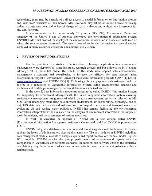
(Envir<strong>on</strong>mental Informati<strong>on</strong> Management s<str<strong>on</strong>g>of</str<strong>on</strong>g>tware). C<strong>on</strong>ceptual model <str<strong>on</strong>g>of</str<strong>on</strong>g> ENVIM is presented <strong>on</strong><br />
Fig. 1.<br />
ENVIM integrates databases <strong>on</strong> envir<strong>on</strong>mental m<strong>on</strong>itoring data with traditi<strong>on</strong>al GIS layers<br />
such as the layers <str<strong>on</strong>g>of</str<strong>on</strong>g> administrati<strong>on</strong>, rivers and streams, etc. The key modules <str<strong>on</strong>g>of</str<strong>on</strong>g> ENVIM including:<br />
data management module; module <str<strong>on</strong>g>of</str<strong>on</strong>g> analysis, query and report preparati<strong>on</strong>; module model (Fig. 2);<br />
WEB module, ENVIM enables the prompt performance <str<strong>on</strong>g>of</str<strong>on</strong>g> envir<strong>on</strong>mental reports with the<br />
comparis<strong>on</strong> to Vietnamese envir<strong>on</strong>ment standards. In additi<strong>on</strong>, the s<str<strong>on</strong>g>of</str<strong>on</strong>g>tware enables the emulative<br />
calculati<strong>on</strong> giving the influences <str<strong>on</strong>g>of</str<strong>on</strong>g> socio-ec<strong>on</strong>omic activities over envir<strong>on</strong>ment polluti<strong>on</strong> within a<br />
regi<strong>on</strong>al scale.<br />
2



![[8] 2002 e-business-strategies-for-virtual-organizations](https://img.yumpu.com/8167654/1/190x257/8-2002-e-business-strategies-for-virtual-organizations.jpg?quality=85)
