Myanmar Protected Areas: Context, Current Status ... - Istituto Oikos
Myanmar Protected Areas: Context, Current Status ... - Istituto Oikos
Myanmar Protected Areas: Context, Current Status ... - Istituto Oikos

You also want an ePaper? Increase the reach of your titles
YUMPU automatically turns print PDFs into web optimized ePapers that Google loves.
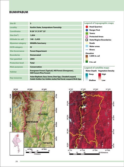
BUMHPABUM<br />
Site ID 3<br />
Locality Kachin State, Sumprabom Township<br />
Coordinates N 26° 31’, E 97° 23’<br />
Size (km²) 1,854<br />
Altitude (m. asl) 140 – 3,435<br />
<strong>Myanmar</strong> category Wildlife Sanctuary<br />
IUCN category IV<br />
Site Governance Forest Department<br />
Boundaries Demarcated<br />
Year gazetted 2004<br />
Protection level Total<br />
Main purposes Conservation<br />
Habitat<br />
Key resources<br />
Evergreen Forest (Typical), Hill Forest (Evergreen),<br />
Hill Forest (Pine Forest)<br />
Asian Elephant, Gaur, Serow, Deer Spp., Clouded Leopard,<br />
Asiatic Golden Cat, Golden Jackal, Red Goral, Leopard, Birds Spp.<br />
Legend of topographic maps<br />
Head Quarters<br />
Ranger Post<br />
Towns<br />
<strong>Protected</strong> <strong>Areas</strong><br />
State/Region Boundaries<br />
Roads<br />
Water areas<br />
Rivers<br />
Elevation<br />
5.800 m. asl<br />
0 m. asl<br />
Legend of satellite maps<br />
Water Depth Vegetation Density<br />
Deep<br />
Shallow<br />
High<br />
Low<br />
<strong>Myanmar</strong> <strong>Protected</strong> <strong>Areas</strong><br />
26 27