Tetlin National Wildlife Refuge - USFWS Alaska Region - U.S. Fish ...
Tetlin National Wildlife Refuge - USFWS Alaska Region - U.S. Fish ...
Tetlin National Wildlife Refuge - USFWS Alaska Region - U.S. Fish ...

You also want an ePaper? Increase the reach of your titles
YUMPU automatically turns print PDFs into web optimized ePapers that Google loves.
Formerly Used Defense Sites<br />
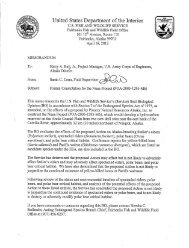
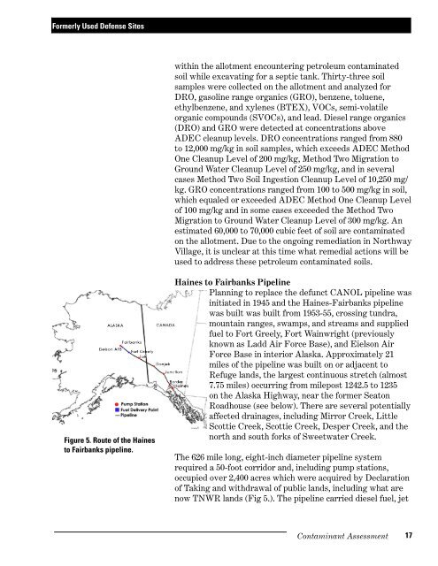
Figure 5. Route of the Haines<br />
to Fairbanks pipeline.<br />
within the allotment encountering petroleum contaminated<br />
soil while excavating for a septic tank. Thirty-three soil<br />
samples were collected on the allotment and analyzed for<br />
DRO, gasoline range organics (GRO), benzene, toluene,<br />
ethylbenzene, and xylenes (BTEX), VOCs, semi-volatile<br />
organic compounds (SVOCs), and lead. Diesel range organics<br />
(DRO) and GRO were detected at concentrations above<br />
ADEC cleanup levels. DRO concentrations ranged from 880<br />
to 12,000 mg/kg in soil samples, which exceeds ADEC Method<br />
One Cleanup Level of 200 mg/kg, Method Two Migration to<br />
Ground Water Cleanup Level of 250 mg/kg, and in several<br />
cases Method Two Soil Ingestion Cleanup Level of 10,250 mg/<br />
kg. GRO concentrations ranged from 100 to 500 mg/kg in soil,<br />
which equaled or exceeded ADEC Method One Cleanup Level<br />
of 100 mg/kg and in some cases exceeded the Method Two<br />
Migration to Ground Water Cleanup Level of 300 mg/kg. An<br />
estimated 60,000 to 70,000 cubic feet of soil are contaminated<br />
on the allotment. Due to the ongoing remediation in Northway<br />
Village, it is unclear at this time what remedial actions will be<br />
used to address these petroleum contaminated soils.<br />
Haines to Fairbanks Pipeline<br />
Planning to replace the defunct CANOL pipeline was<br />
initiated in 1945 and the Haines-Fairbanks pipeline<br />
was built was built from 1953-55, crossing tundra,<br />
mountain ranges, swamps, and streams and supplied<br />
fuel to Fort Greely, Fort Wainwright (previously<br />
known as Ladd Air Force Base), and Eielson Air<br />
Force Base in interior <strong>Alaska</strong>. Approximately 21<br />
miles of the pipeline was built on or adjacent to<br />
<strong>Refuge</strong> lands, the largest continuous stretch (almost<br />
7.75 miles) occurring from milepost 1242.5 to 1235<br />
on the <strong>Alaska</strong> Highway, near the former Seaton<br />
Roadhouse (see below). There are several potentially<br />
affected drainages, including Mirror Creek, Little<br />
Scottie Creek, Scottie Creek, Desper Creek, and the<br />
north and south forks of Sweetwater Creek.<br />
The 626 mile long, eight-inch diameter pipeline system<br />
required a 50-foot corridor and, including pump stations,<br />
occupied over 2,400 acres which were acquired by Declaration<br />
of Taking and withdrawal of public lands, including what are<br />
now TNWR lands (Fig 5.). The pipeline carried diesel fuel, jet<br />
Contaminant Assessment<br />
17