Species composition and community structure of forest stands in ...
Species composition and community structure of forest stands in ...
Species composition and community structure of forest stands in ...

Create successful ePaper yourself
Turn your PDF publications into a flip-book with our unique Google optimized e-Paper software.
170 FOREST STRUCTURE IN KUMAON HIMALAYA<br />
Density <strong>and</strong> diversity estimates<br />
Density <strong>of</strong> trees, shrubs <strong>and</strong> ground vegetation<br />
was calculated follow<strong>in</strong>g Greig - Smith (1983). The<br />
diversity values for each layer (tree, shrub <strong>and</strong><br />
ground vegetation) were calculated us<strong>in</strong>g Shannon<br />
- Wiener’s diversity <strong>in</strong>dex follow<strong>in</strong>g Magurran<br />
(1988). The species richness was calculated us<strong>in</strong>g<br />
Margelef’s species richness <strong>in</strong>dex (Magurran<br />
1988). One-way ANOVA (Zar 1984) was used to<br />
detect significant differences <strong>in</strong> density, diversity<br />
<strong>and</strong> richness for the vegetation layers <strong>in</strong> all the<br />
surveyed <strong>forest</strong> st<strong>and</strong>s.<br />
Classification <strong>and</strong> ord<strong>in</strong>ation <strong>of</strong> species <strong>and</strong><br />
sites<br />
The vegetation was classified on the basis <strong>of</strong><br />
tree species <strong>and</strong> dom<strong>in</strong>ant ground vegetation<br />
(shrub <strong>and</strong> herb species) us<strong>in</strong>g TWINSPAN (Twoway<br />
<strong>in</strong>dicator species analysis) computer program<br />
(Hill 1979 a). Same data matrix was used for<br />
ord<strong>in</strong>ation <strong>of</strong> tree species as well as sites (<strong>forest</strong><br />
st<strong>and</strong>s) through Detrended Correspondence<br />
Analysis (DCA) <strong>in</strong> computer program DECORANA<br />
(Hill 1979 b). The vegetation attributes (density,<br />
diversity <strong>and</strong> richness) <strong>of</strong> the 23 sites along with<br />
altitude, number <strong>of</strong> stumps, lopped trees <strong>and</strong> cattle<br />
dung were subjected to Pr<strong>in</strong>cipal Component<br />
Analysis (PCA).<br />
Stepwise multiple regression was used to<br />
obta<strong>in</strong> correlation between the DCA axes, <strong>and</strong><br />
measured environmental <strong>and</strong> vegetation<br />
attributes. All data matrices were st<strong>and</strong>ardized<br />
follow<strong>in</strong>g Zar (1984) to achieve normality <strong>and</strong><br />
reduce heteroscadesticity.<br />
Rarity <strong>in</strong>dex<br />
A rarity <strong>in</strong>dex was generated to identify rare<br />
tree species <strong>of</strong> Kumaon. For this purpose two<br />
parameters were taken <strong>in</strong>to account-<br />
a) Qualitative proportion <strong>of</strong> each tree species <strong>in</strong><br />
Kumaon (PQA)<br />
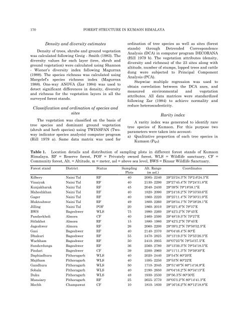
Table 1. Location details <strong>and</strong> distribution <strong>of</strong> sampl<strong>in</strong>g plots <strong>in</strong> different <strong>forest</strong> st<strong>and</strong>s <strong>of</strong> Kumaon<br />
Himalaya. RF = Reserve <strong>forest</strong>, POF = Privately owned <strong>forest</strong>, WLS = Wildlife sanctuary, CF =<br />
Community <strong>forest</strong>, Alt. = Altitude, m = meter, asl = above sea level, BWS = B<strong>in</strong>sar Wildlife Sanctuary.<br />
Forest st<strong>and</strong> District Status Sampl<strong>in</strong>g<br />
Plots<br />
Alt. Range<br />
(m asl.)<br />
Coord<strong>in</strong>ates<br />
Kilbery Na<strong>in</strong>i Tal RF 40 2085- 2240 29°25'24.3"N 79°2.6'24.3"E<br />
V<strong>in</strong>aiyak Na<strong>in</strong>i Tal RF 40 2130- 2290 29°27'45.4"N 79°24'31.8"E<br />
Kunjakharak Na<strong>in</strong>i Tal RF 45 2040- 2430 29°39'N 79°18'58.1"E<br />
Maheshkhan Na<strong>in</strong>i Tal RF 40 1820- 2090 29°24'16.2"N 79°33'50.6"E<br />
Gager Na<strong>in</strong>i Tal RF 40 1860- 2220 29°25'11.4"N 79°30'31.9"E<br />
Mukteshwer Na<strong>in</strong>i Tal RF 49 1800- 2260 29°28'34.1"N 79°38'28.1"E<br />
Jill<strong>in</strong>g Na<strong>in</strong>i Tal POF 20 1860- 2010 29°22'1.6"N 79°37'E<br />
BWS Bageshwer WLS 75 1990- 2260 29°42'3.2"N 79°45'E<br />
P<strong>and</strong>avkholi Almora CF 40 2460- 2590 29°48'19.5"N 79°27'E<br />
Sitlakhet Almora RF 15 1880- 1980 29°42'3.2"N 79°45'E<br />
Jageshwer Almora RF 26 2060- 2200 29°39'3.2"N 79°50'52.5"E<br />
Gasi Bageshwer RF 40 2140- 2370 30°04'48.4"N 80°E<br />
Dhakuri Bageshwer RF 55 2470- 2825 30°13'19.5"N 79°55'26.3"E<br />
Wachham Bageshwer RF 50 2410- 2935 30°07'25"N 79°54'37.5"E<br />
Sunderdunga Bageshwer RF 36 2560- 2780 30°13'30.3"N 79°54'18.5"E<br />
P<strong>in</strong>dari Bageshwer CF 39 2200- 2960 30°11'11.3"N 79°59'30"E<br />
Daphiadhura Pithoragarh WLS 40 2020- 2440 29°54'N 80°20'E<br />
Majtham Pithoragarh WLS 40 1595- 2250 29°53'N 80°22'E<br />
G<strong>and</strong>hura Pithoragarh WLS 50 1710- 2045 29°51'40"N 80°14'16.9"E<br />
Sobala Pithoragarh WLS 40 2190- 2650 30°04'16.2"N 80°34'15"E<br />
Duku Pithoragarh WLS 48 1930- 2530 29°56.3'N 80°30'E<br />
Munsiary Pithoragarh RF 25 2655- 2770 30°05'3.2"N 80°14'41.3"E<br />
Mechh Champawat CF 10 1810- 1830 29°16'16.2"N 80°12'18.8"E