Chapter 3 - SA Urban Forest Biodiversity Program
Chapter 3 - SA Urban Forest Biodiversity Program
Chapter 3 - SA Urban Forest Biodiversity Program

You also want an ePaper? Increase the reach of your titles
YUMPU automatically turns print PDFs into web optimized ePapers that Google loves.
Administrative Boundaries<br />
The Adelaide Metropolitan Area includes 20<br />
Local Government Areas (see Appendix 4). It<br />
completely encompasses 18 of these and<br />
includes the western third of the Adelaide Hills<br />
Council. The Adelaide Metropolitan Area also<br />
includes<br />
a small portion (166ha) of the District<br />
Council of Kapunda Light, north of the Gawler<br />
River and east of Main North Road.<br />
The Adelaide Metropolitan Area covers part of<br />
three Soil Conservation Board Districts and<br />
directly adjoins one other (see Appendix 4).<br />
Biological boundaries<br />
In the interests of planning for the National<br />
Reserves<br />
System, the Interim Biogeographic<br />
Regionalisation for Australia (IBRA) has<br />
recently divided Australia into 80 discrete<br />
biological regions (Thackway & Cresswell<br />
1995).<br />
Metropolitan Adelaide falls into parts of<br />
two IBRA regions, The Mount<br />
Lofty Block and<br />
the Eyre/Yorke Block (see Appendix 4). The<br />
Mount Lofty Block extends from the<br />
Quorn/Crystal Brook region in a narrow band<br />
along both sides of the ranges south to the tip of<br />
the Fleurieu Peninsula and includes Kangaroo<br />
Island. The Eyre/Yorke Block includes Eyre<br />
and Yorke Peninsula, but also extends down the<br />
northern Adelaide Plains in a south westerly<br />
direction from Gawler to the suburb of Cavan.<br />
All land south of this line is included in the<br />
Mount Lofty Block. The Eyre/Yorke Block<br />
should really extend further south on the<br />
Adelaide Plains to approximately Aldinga, as<br />
this region is biologically more like the<br />
Eyre/Yorke Block than the Mount Lofty Block.<br />
It is expected that this inaccuracy will be<br />
addressed following a comprehensive review of<br />
IBRA (Tim Bond pers. comm.).<br />
While it is preferred that biodiversity plans be<br />
prepared and implemented according to<br />
biogeographic regions, it is considered that the<br />
metropolitan area has unique issues that require<br />
addressing at this social/administrative level.<br />
3.4 Physical Description<br />
Climate<br />
Metropolitan Adelaide has a mediterranean<br />
climate, consisting of long hot summers<br />
and<br />
cool wet winters. Yet across the region,<br />
there is<br />
significant variation in both temperature and<br />
rainfall, with a general trend of increasing<br />
rainfall from west to east (see Appendix 4).<br />
This variation is largely a result of variation in<br />
topography. Areas adjacent to Mount Lofty<br />
receive the highest average annual rainfall, with<br />
Stirling receiving an average of 1189mm of rain<br />
per annum. Areas to the north and west receive<br />
the lowest average annual rainfall; Edinburgh on<br />
the northern Adelaide Plains receives, on<br />
average, 440mm of rain each year.<br />
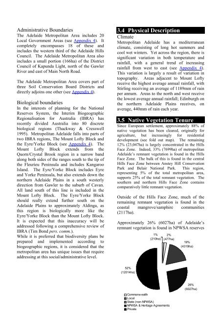
3.5 Native Vegetation Tenure<br />
Since European settlement, approximately 88% of<br />
native vegetation has been cleared, originally for<br />
agriculture,<br />
but increasingly for residential<br />
development (see fold out map). The remaining<br />
12% (23,047ha) is largely concentrated in the Hills<br />
Face Zone. Indeed, 33% (7699ha) of metropolitan<br />
Adelaide’s remnant vegetation is found in the Hills<br />
Face Zone. The bulk of this is found in the central<br />
Hills Face Zone between Anstey Hill Conservation<br />
Park and Belair National Park. This region,<br />
representing 5% of the total metropolitan area,<br />
supports 25% of the total remnant vegetation. The<br />
southern and northern Hills Face Zone contains<br />
comparatively little remnant vegetation.<br />
Outside of the Hills Face Zone, much of the<br />
remaining remnant vegetation is found in the<br />
coastal<br />
(2117ha).<br />
mangrove/samphire communities<br />
Approximately 26% (6027ha) of Adelaide’s<br />
remnant vegetation is found in NPW<strong>SA</strong> reserves<br />
52%<br />
(12014ha)<br />
1%<br />
(210ha)<br />
2%<br />
(477ha)<br />
Commonw ealth<br />
Local<br />
State (non-NPW<strong>SA</strong>)<br />
NPW<strong>SA</strong> & Heritage Agreements<br />
Private<br />
19%<br />
(4319ha)<br />
26%<br />
(6027ha)