tidal hardwood swamps - Maryland Department of Natural Resources
tidal hardwood swamps - Maryland Department of Natural Resources
tidal hardwood swamps - Maryland Department of Natural Resources

You also want an ePaper? Increase the reach of your titles
YUMPU automatically turns print PDFs into web optimized ePapers that Google loves.
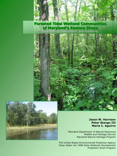
Forested Tidal Wetland Communities<br />
<strong>of</strong> <strong>Maryland</strong>’s Eastern Shore<br />
Identification, Assessment, and Monitoring<br />
Jason W. Harrison<br />
Peter Stango III<br />
Maria C. Aguirre<br />
<strong>Maryland</strong> <strong>Department</strong> <strong>of</strong> <strong>Natural</strong> <strong>Resources</strong><br />
Wildlife and Heritage Service<br />
<strong>Maryland</strong> <strong>Natural</strong> Heritage Program<br />
The United States Environmental Protection Agency<br />
Clean Water Act 1998 State Wetlands Development<br />
Protection Grant Program
FORESTED TIDAL WETLAND COMMUNITIES OF<br />
MARYLAND’S EASTERN SHORE:<br />
Identification, Assessment and Monitoring<br />
prepared by:<br />
Jason W. Harrison, Peter Stango III and Maria C. Aguirre<br />
<strong>Maryland</strong> <strong>Natural</strong> Heritage Program<br />
<strong>Maryland</strong> <strong>Department</strong> <strong>of</strong> <strong>Natural</strong> <strong>Resources</strong><br />
Annapolis, <strong>Maryland</strong><br />
March 2004<br />
prepared for:<br />
The United States Environmental Protection Agency Clean Water Act 1998<br />
State Wetlands Protection Development Grant Program<br />
[U.S. EPA Reference Wetland <strong>Natural</strong> Communities <strong>of</strong> <strong>Maryland</strong>’s Forested Tidal Wetlands Grant # CD-983592]
Citation:<br />
Harrison, J.W., P. Stango III, and M.C. Aguirre. 2004. Forested <strong>tidal</strong> wetland communities <strong>of</strong> <strong>Maryland</strong>’s Eastern<br />
Shore: identification, assessment, and monitoring. <strong>Maryland</strong> <strong>Department</strong> <strong>of</strong> <strong>Natural</strong> <strong>Resources</strong>, <strong>Natural</strong> Heritage<br />
Program, Annapolis, <strong>Maryland</strong>. Unpublished report submitted to the Environmental Protection Agency. 96 pp.
TABLE OF CONTENTS<br />
Acknowledgements ....................................................................................................................................... 2<br />
Introduction ................................................................................................................................................... 3<br />
Purpose......................................................................................................................................................... 5<br />
Methods......................................................................................................................................................... 5<br />
Landscape Analysis ......................................................................................................................... 5<br />
Spatial Distribution <strong>of</strong> Vegetation: Implications for Sampling Design .............................................. 6<br />
Field Surveys .................................................................................................................................. .6<br />
Data Compilation and Analysis ........................................................................................................ 9<br />
Results ........................................................................................................................................................ 11<br />
Discussion................................................................................................................................................... 12<br />
Tidal Hardwood Swamps – Community Descriptions……………………………………..………………..17<br />
Fraxinus pennsylvanica – Acer rubrum / Polygonum spp. Tidal Woodland (CEGL006165)………… …….19<br />
Fraxinus pr<strong>of</strong>unda – Nyssa biflora / Ilex verticillata / Polygonum arifolium Tidal Woodland (CEGL006287)<br />
.................................................................................................................................................................... 23<br />
Tidal Bald Cypress Forests/Woodlands – Community Descriptions…………………………… ………27<br />
Taxodium distichum – Nyssa biflora / Bignonia capreolata Tidal Forest (CEGL006850)…………………. 29<br />
Taxodium distichum / Carex hyalinolepis Tidal Woodland (CEGL006845)…………………………………. 33<br />
Tidal Loblolly Pine Woodlands – Community Descriptions…….…………………………………………37<br />
Pinus taeda – Morella cerifera / Spartina patens Tidal Woodland (CEGL006849) .................................... 39<br />
Reference Sites........................................................................................................................................... 43<br />
Upper Patuxent River.................................................................................................................................. 45<br />
Marshyhope Creek...................................................................................................................................... 49<br />
Pocomoke River.......................................................................................................................................... 53<br />
Hickory Point Cypress Swamp.................................................................................................................... 57<br />
Moneystump Swamp – Blackwater River ................................................................................................... 61<br />
Pictorial Overview…………………………………………………………………………………………….……..65<br />
Project Map…………………………………………………………………………………………………………..77<br />
Literature Cited………………………………………………………………………………………………………79<br />
Appendix 1: Sample Field Forms................................................................................................................ 85<br />
Appendix 2: Definitions <strong>of</strong> State and Federal Ranking ............................................................................... 89<br />
Appendix 3: List <strong>of</strong> Common and Scientific Names <strong>of</strong> Vascular Plants…….…………………………………93<br />
1
ACKNOWLEDGEMENTS<br />
We would like to express our appreciation to the following agencies, organizations, and people for their<br />
time and support: The United States Environmental Protection Agency for providing funding through the<br />
Clean Water Act’s 1998 State Wetlands Protection Development Grant Program; Gwen Brewer, Lynn<br />
Davidson, Rebecca Eanes, Chris Frye, Wesley Knapp, Holly Sepety, Scott Smith, and Glenn Therres, all<br />
with the <strong>Maryland</strong> <strong>Natural</strong> Heritage Program, Bill McAvoy and Pete Bowman with the Delaware <strong>Natural</strong><br />
Heritage Program, Gary Fleming and Phil Coulling with the Virginia <strong>Natural</strong> Heritage Program, Doug<br />
Samson with The Nature Conservancy for consultation, Rod Simmons with the <strong>Maryland</strong> Native Plant<br />
Society, Cel Petro with the Information Resource Center, and the many private landowners for permitting<br />
access to survey locations.<br />
The field work, data analyses, and report writing for this project was conducted by Peter Stango III, Maria<br />
Aguirre, and Jason W. Harrison. In addition, major portions <strong>of</strong> the Introduction and Methods sections <strong>of</strong><br />
the report have been modified and adapted from Harrison (2001) and Harrison and Stango (2003).<br />
2
INTRODUCTION<br />
In recent years, the practice <strong>of</strong> natural resource conservation through the protection <strong>of</strong> rare, threatened,<br />
and endangered species has come under fire by both the general public and the scientific community<br />
(Wilcove et al. 1996). These species have served as regulatory endpoint umbrellas, used to protect the<br />
larger systems that they inhabit. These procedures have led to the focus <strong>of</strong> conservation efforts onto<br />
majestic species like the Bald Eagle and charming species like the Spotted Owl (Harwell et al. 1990).<br />
These species have acted as representatives for their natural systems, but rare species usually do not<br />
play a major ecological role within these systems. Actually, the endpoints <strong>of</strong> conservation efforts should<br />
be the natural systems themselves (Harwell et al. 1990). Originally, these representatives served their<br />
systems well; it is difficult to induce the public to feel strongly about the conservation <strong>of</strong> ecologically<br />
important endpoints such as predatory mites (Pimentel and Edwards 1982) and other invertebrates<br />
(Wilson 1987), arbuscular mycorhizal fungi (Van der Heijden et al. 1998), or the nitrogen cycle (Barbour<br />
et al. 1987). But, land protection based on charismatic endangered animal species can create a great<br />
deal <strong>of</strong> public controversy (e.g. Spotted Owl conservation in the Pacific Northwest) and <strong>of</strong>ten leaves many<br />
questions unresolved (Williams 1996). What happens to land that is currently protected, because <strong>of</strong> the<br />
presence <strong>of</strong> a species, once that species recovers and is de-listed? What happens to the same type <strong>of</strong><br />
land if the species becomes extinct? Also, these conservation concepts can lead to the intentional<br />
degradation <strong>of</strong> private land in order to ensure that no endangered species move in and create a<br />
regulatory situation, such as in the case <strong>of</strong> the Red-cockaded Woodpecker in the Southeastern United<br />
States (Bean and Wilcove 1997, Bonnie 1997).<br />
The complications associated with species level conservation have given rise to a relatively new method<br />
in the protection <strong>of</strong> natural resources. Vegetation communities have been identified as generally<br />
appropriate units <strong>of</strong> biodiversity conservation, they are hierarchically above individual species but more<br />
manageable than larger landscape units such as watersheds or physiographic provinces (Thompson<br />
1996). The definition <strong>of</strong> vegetation communities used in this report closely follows that <strong>of</strong> Mueller-<br />
Dombois and Ellenberg (1974): communities are physiognomically uniform assemblages <strong>of</strong> plants which<br />
are ecologically related to each other and their physical environment, and predictably found under similar<br />
habitat conditions. The abiotic environment is not a component <strong>of</strong> the definition <strong>of</strong> vegetation<br />
communities; it is assumed that these conditions determine the combination <strong>of</strong> species within the concept<br />
(Thompson 1996). Often, the vegetation community descriptions are necessarily vague, recognizing that<br />
these associations intergrade at ecotones and that boundaries are artificial constructs necessary for<br />
conservation. Vegetation communities are merely empirical tools used for natural resource conservation,<br />
not an absolute representation <strong>of</strong> ecological truth (Thompson 1996).<br />
Historically, a debate has transpired as to whether vegetation actually consists <strong>of</strong> distinct communities or<br />
a continuum <strong>of</strong> overlapping species ranges (Grossman et al. 1994). Much <strong>of</strong> this discussion centered<br />
around the “supra-organism” view <strong>of</strong> F. E. Clements (1936) versus the “individualistic” view <strong>of</strong> H. Gleason<br />
(1926). A full treatise <strong>of</strong> this debate can be found in Whittaker (1962) and Mueller-Dombois and<br />
Ellenberg (1974). More recently, Austin and Smith (1989) have reevaluated this debate and emphasized<br />
that there is not actually a polar dichotomy between these two concepts, rather the frames <strong>of</strong> reference <strong>of</strong><br />
the observer are in conflict. Vegetation patterns are characterized by the link between individual species<br />
distribution patterns, their occurrence in landscape features, and the distribution <strong>of</strong> the landscape features<br />
(Grossman et al. 1994). Species can be individually distributed along gradients, uni-dimensional or<br />
complex, following any possible model (Austin 1987, Austin and Smith 1989). The pattern <strong>of</strong> distribution<br />
<strong>of</strong> the landscape features that control environmental factors constrains the pattern <strong>of</strong> species<br />
combinations, their distribution in the landscape, and their frequency (Grossman et al. 1994). Thus the<br />
views <strong>of</strong> community and continuum complement, rather than exclude each other (Westh<strong>of</strong>f and Van der<br />
Maarel 1978, Austin 1991).<br />
Vegetation communities are a tractable level <strong>of</strong> hierarchy for establishing preservation benchmarks<br />
because their conservation allows the protection <strong>of</strong> the overall trophic structure, which is essentially<br />
3
iodiversity (Harwell et al. 1990). Also, there are some legal provisions for protecting vegetation<br />
communities: Section 403 © <strong>of</strong> the Federal Water Pollution Control Act specifically calls for consideration<br />
<strong>of</strong> changes in species diversity (Harwell 1984b), and Section 301(h) <strong>of</strong> the Federal Water Pollution<br />
Control Act indirectly calls for maintenance <strong>of</strong> species diversity through its “balanced indigenous<br />
population” endpoint as interpreted by regulations and litigation (Harwell 1984a). Generally, high priority<br />
vegetation communities are habitat to high priority plant and animal species, protection <strong>of</strong> the community<br />
will protect these species (Keddy and Wisheu 1989; Noss 1987). Conservation using this “coarse-filter”<br />
approach has been documented for some taxa (Panzer and Schwartz 1998). Also, vegetation<br />
communities, with their associated biological, chemical, and physical processes, drive the biogeochemical<br />
processes <strong>of</strong> the earth (Naeem et al. 1994). Vegetation community based inventories give a better<br />
assessment <strong>of</strong> the status, distribution, and interrelatedness <strong>of</strong> vegetation types across the landscape as<br />
compared to the historically more prevalent methods <strong>of</strong> jurisdictionally based (ie. county or agency)<br />
inventory. Often, these types <strong>of</strong> inventory are limited to smaller geographic land units, lead to haphazard<br />
data collection, and conclude with improper understanding <strong>of</strong> community rarity.<br />
Unlike species, vegetation communities are not always self-evident on the landscape. A series <strong>of</strong> floristic<br />
data, collected across both geographic and temporal gradients, is <strong>of</strong>ten necessary for naming and<br />
understanding vegetation community types. This information must be expressed within the organizational<br />
framework <strong>of</strong> a community classification for the best utilization <strong>of</strong> the biological data. This classification is<br />
a way <strong>of</strong> collecting uniform hierarchical data that facilitates effective resource stewardship by ensuring<br />
compatibility and widespread use <strong>of</strong> the information by various individuals and agencies (Grossman et al.<br />
1994). The United States National Vegetation Classification System (USNVC; Grossman et al. 1998) is a<br />
current priority <strong>of</strong> NatureServe and the network <strong>of</strong> <strong>Natural</strong> Heritage Programs. This system is the product<br />
<strong>of</strong> a great body <strong>of</strong> earlier scientific work and over twenty years <strong>of</strong> data collection by these organizations.<br />
Classification is a critical ingredient in the recipe <strong>of</strong> conservation, it allows for the accurate identification<br />
and description <strong>of</strong> the full range <strong>of</strong> vegetation community types within the landscape. This along with<br />
information on rarity permits formation <strong>of</strong> proper protection priorities.<br />
Within the framework <strong>of</strong> the USNVC (Grossman et al. 1998) are hierarchically more finely divided<br />
classifications at the regional and state levels. This project contributes to the development <strong>of</strong> the<br />
<strong>Maryland</strong> natural community classification (Harrison 2004b) which is used for management within the<br />
state, comparison to other states, and fine tuning community alliances and associations <strong>of</strong> the USNVC<br />
(Grossman et al. 1998). In addition, development <strong>of</strong> the classification through a series <strong>of</strong> "special<br />
projects", intensely focusing on a small subset <strong>of</strong> community types, yields the required detailed<br />
description <strong>of</strong> community types as well as the identification and mapping <strong>of</strong> exemplary examples <strong>of</strong> these<br />
types as reference sites.<br />
With the exception to portions <strong>of</strong> Garrett and Worcester Counties, the entire land surface area <strong>of</strong><br />
<strong>Maryland</strong> lies within the Chesapeake Bay drainage basin. This is one <strong>of</strong> the largest and most productive<br />
estuaries in the United States (Lipson and Lipson 1997). All <strong>of</strong> the wetlands within the Chesapeake<br />
drainage are integral to the healthy function <strong>of</strong> the Bay. The phrase "Chesapeake Bay Drainage” is<br />
painted on the storm drains in Baltimore City and “The Bay Starts Here” stickers adorn the sinks <strong>of</strong> many<br />
public bathrooms. These statements are also true <strong>of</strong> the wetlands scattered throughout the state. In<br />
order to truly protect the Bay, the sources and buffers throughout its watershed must receive protection<br />
priority. In addition to their connection with the Chesapeake Bay, <strong>Maryland</strong>’s wetlands are critical habitat<br />
for numerous rare, threatened, and endangered plant and animal species and serve valuable ecosystem<br />
functions such as flood control, water filtration, and nutrient recycling (Tiner and Burke 1995).<br />
Fragmentation and development pressures are degrading <strong>Maryland</strong>’s wetland resources at an alarming<br />
rate. An estimated 1.2 million acres <strong>of</strong> wetlands occurred in <strong>Maryland</strong> before European settlement, but<br />
that number is now reduced to 600,000 acres (Tiner and Burke 1995). Of these 600,000 acres <strong>of</strong><br />
wetlands, approximately 57 percent are represented by palustrine wetlands and 42 percent are<br />
represented by estuarine wetlands (Tiner and Burke 1995). According to the Tiner and Finn (1986) study,<br />
4
a significant decline in palustrine (6%) and estuarine (8%) emergent wetland acreage occurred from 1955<br />
to 1978. Conversion <strong>of</strong> <strong>tidal</strong> wetlands to deepwater habitat, creation <strong>of</strong> saltwater and freshwater<br />
impoundments, ditching, and the overall lack <strong>of</strong> Federal and State wetland regulations during this period<br />
facilitated much <strong>of</strong> the acreage loss. This drastic loss has also accelerated the need for more qualitative<br />
information on the character and significance <strong>of</strong> these wetland resources. This information is necessary<br />
for setting protection priorities and initiating existing protection mechanisms. This study was restricted to<br />
all forested <strong>tidal</strong> wetlands on <strong>Maryland</strong>’s Eastern Shore, with the exception <strong>of</strong> <strong>tidal</strong> portions <strong>of</strong> the<br />
Potomac and Patuxent Rivers where exemplary stands where known to occur.<br />
One impediment to wetland protection and restoration efforts is the lack <strong>of</strong> adequate benchmarks against<br />
which to assess ecological integrity. The health <strong>of</strong> an ecosystem is difficult, if not impossible to assess<br />
without explicit knowledge <strong>of</strong> the target community. Objective measures <strong>of</strong> the impacts <strong>of</strong> anthropogenic<br />
disturbance on the complex and vast ecosystems <strong>of</strong> <strong>Maryland</strong>’s forested <strong>tidal</strong> wetlands present a<br />
daunting challenge. The measurement <strong>of</strong> these stresses, documentation <strong>of</strong> changes, and estimation <strong>of</strong><br />
geographic cover depends upon the identification <strong>of</strong> basic units <strong>of</strong> these wetlands, the component<br />
communities, which are some <strong>of</strong> the end products <strong>of</strong> this project.<br />
PURPOSE<br />
The purpose <strong>of</strong> this project was to classify and describe forested <strong>tidal</strong> wetlands on <strong>Maryland</strong>’s Eastern<br />
Shore in an effort to develop a more complete understanding <strong>of</strong> these communities. The classification<br />
generated by this study and presented in this report will be used to augment the ongoing <strong>Maryland</strong><br />
natural community classification (Harrison 2004b) and the USNVC (Grossman et al. 1998). With this<br />
classification, exemplary examples <strong>of</strong> each community type were identified and described as reference<br />
sites. The information gathered in this project will be used to complement other projects studying <strong>tidal</strong><br />
wetlands in the eastern United States.<br />
The information generated by this project will simplify the regulatory review <strong>of</strong> these <strong>tidal</strong> wetlands by<br />
providing the quantitative data necessary to objectively rank these communities as to their rarity and<br />
biological importance. The results <strong>of</strong> this study will be used to aid in the conservation <strong>of</strong> rare<br />
communities, to assist in current regulation, to support vegetation mapping projects and to interpret<br />
regional data at higher hierarchical levels. They will also be used by the US EPA cooperators to<br />
determine baseline levels <strong>of</strong> parameters within reference wetlands for long-term modeling and<br />
conservation.<br />
The end products <strong>of</strong> this project are: a detailed vegetation community classification and description and<br />
reference site descriptions for long term monitoring. These products will be utilized by the <strong>Maryland</strong><br />
<strong>Department</strong> <strong>of</strong> the Environment: Non-<strong>tidal</strong> Wetlands and Waterways Division, <strong>Maryland</strong> <strong>Department</strong> <strong>of</strong><br />
<strong>Natural</strong> <strong>Resources</strong>: Wildlife and Heritage Service, NatureServe, and traditional users <strong>of</strong> the <strong>Natural</strong><br />
Heritage’s Biological Conservation Database.<br />
METHODS<br />
Landscape Analysis<br />
In order to collect ecologically pertinent information, the intricate process <strong>of</strong> Landscape Analysis must<br />
supersede field surveys. The process starts with the development <strong>of</strong> a preliminary definition <strong>of</strong> the abiotic<br />
and biotic factors that contribute to the community structure <strong>of</strong> the system <strong>of</strong> study. Our definition <strong>of</strong><br />
forested <strong>tidal</strong> wetlands was primarily based on that defined within the literature. For the purposes <strong>of</strong> this<br />
study, forested <strong>tidal</strong> wetlands are broadly defined as diurnal to irregularly flooded palustrine or estuarine<br />
wetlands dominated by trees greater than 6m in height and greater than 5% in cover. Depending on<br />
canopy coverage different physiognomic classes are represented in this broad definition. Included are<br />
sparse woodland (5-25% cover), woodland (25-60% cover), and forested (60-100% cover) classes.<br />
5
Once a clear search image was established, the process <strong>of</strong> assembling a portfolio <strong>of</strong> potential sites<br />
occurred using the standard methodologies employed by The Nature Conservancy and the network <strong>of</strong><br />
state <strong>Natural</strong> Heritage Programs. The primary method <strong>of</strong> selecting sample sites was facilitated through<br />
the use <strong>of</strong> digital orthophotographic quadrangles coupled with National Wetland Inventory maps. At the<br />
completion <strong>of</strong> the Landscape Analysis phase <strong>of</strong> the project, 227 potential survey sites were identified. If<br />
required, owners <strong>of</strong> private land and managers <strong>of</strong> public land were contacted and site visits were<br />
approved. If required, proper plant collection permits for public and private land were obtained.<br />
Landscape analysis for this project occurred during the period from January 2003 to April 2003.<br />
Spatial Distribution <strong>of</strong> Vegetation: Implications for Sampling Design<br />
An effective and accurate vegetation classification requires sampling the full range <strong>of</strong> compositional<br />
heterogeneity, but the complex spatial nature <strong>of</strong> vegetation presents a number <strong>of</strong> problems when<br />
designing an optimal sampling scheme at the landscape scale (Grossman et al. 1994). Some<br />
characteristics <strong>of</strong> a good sampling approach are flexibility, replicability, and cost effectiveness; it attempts<br />
to characterize as many vegetation patterns possible with efficiency in mind (Grossman et al. 1994). Due<br />
to time, budgetary constraints, and large geographic area <strong>of</strong> <strong>Maryland</strong>'s Eastern Shore, it was implausible<br />
to use the methods <strong>of</strong> multiple random plot samples <strong>of</strong> a single vegetation type at one site or repeated<br />
sampling <strong>of</strong> single plots over time to capture the overall composition. Also, randomization procedures<br />
may actually be counterproductive to the intent <strong>of</strong> ecological surveys, especially where the occurrences <strong>of</strong><br />
natural patterns are known to be non-random (Gillison and Brewer 1985). In general, plant communities<br />
do not occur randomly on the landscape, they occur where the abiotic factors constrain the individual<br />
species that constitute the community. Although sampling theory emphasizes randomization in order to<br />
provide a probability structure for statistical analysis or to give credibility to statistical models, the recovery<br />
<strong>of</strong> vegetation patterns are not necessarily accomplished by standard statistical sampling procedures<br />
(Gillison and Brewer 1985).<br />
To compensate for these restrictions, an inherently subjective method <strong>of</strong> selecting sample locations was<br />
employed to capture the full floristic range, both among and within vegetation types. While the number <strong>of</strong><br />
samples within each vegetation type was proportional to its abundance across the entire landscape, types<br />
with greater within-type heterogeneity required more intensive sampling.<br />
Field Surveys<br />
Sampling was stratified such that vegetation types were sampled in approximate proportion to their<br />
representation on the landscape, and sampling occurred across the entire eastern shore region <strong>of</strong><br />
<strong>Maryland</strong>. Attempts were made to capture the full range <strong>of</strong> variation in local conditions, including<br />
hydrological regime, inundation frequency, salinity, soil drainage class, soil texture, and elevation. A<br />
random approach was used to the extent possible to aid in the selection <strong>of</strong> sites from the set <strong>of</strong> potential<br />
sites, but several factors contributed to the need for a primarily subjective and non-random approach to<br />
the actual location and configuration <strong>of</strong> sample plots. These include the need to place plots in<br />
homogeneous vegetation, the necessity to capture as much <strong>of</strong> the floral heterogeneity <strong>of</strong> a site as<br />
possible, the desire to ease future relocation, and the existence <strong>of</strong> restrictions on site access.<br />
The field work for this project occurred during the 2003 growing season and followed standard vegetation<br />
sampling protocols utilized by The Nature Conservancy and the network <strong>of</strong> state <strong>Natural</strong> Heritage<br />
Programs (Sneddon 1993). The sites identified in landscape analysis were visited and given an initial<br />
qualitative rank, which is a relative scale where “A” is excellent, “B” is good, “C” is marginal or fair, and “D”<br />
is poor. The ranking was based on four factors: Quality, Condition, Viability, and Defensibility. Only<br />
those sites receiving ranks A - C qualified for quantitative survey. Knowledge <strong>of</strong> the history <strong>of</strong> land<br />
management was also important for the initial ranking (Grossman et al. 1994). These surveys attempted<br />
to avoid ecotones and areas subjected to significant disturbance events.<br />
6
Site selection and plot layout placed plots in fairly homogeneous vegetation and avoided sites recently<br />
disturbed by human activities or natural events that may have resulted in atypical composition or<br />
structure. Plots were small enough to encompass homogeneous vegetation and uniform local conditions<br />
and large enough to capture the full range <strong>of</strong> within-community variation in species composition and<br />
vegetation structure.<br />
Vegetation Sampling<br />
At each survey site, project ecologists became familiar with the vegetation and potential vegetation<br />
communities. Then, one temporary survey plot was established in the most representative location for<br />
each potential community type at each site. The <strong>Natural</strong> Heritage Methodology utilizes 10 m X 10 m (100<br />
m 2 ) for herbaceous vegetation, 15 m X 15 m (225 m 2 ) for shrubland vegetation, and 20 m X 20 m (400<br />
m 2 ) for forest vegetation, as recommended by Mueller-Dombois and Ellenberg (1974). Botanical<br />
nomenclature follows that <strong>of</strong> Kartesz (1999).<br />
Each plot was surveyed for presence <strong>of</strong> all vascular plant species rooted in the plot and the percent<br />
ground cover was recorded for each species and then converted to the appropriate cover class (Table 1).<br />
Cover was estimated by a summation <strong>of</strong> vertical projections <strong>of</strong> the canopies <strong>of</strong> each individual <strong>of</strong> each<br />
species and recorded as a percentage, with a maximum value <strong>of</strong> 100. Any species not rooted within the<br />
survey plot, but included in the community were recorded and assigned a cover <strong>of</strong> zero. The total percent<br />
cover for each physiognomic strata was estimated and the dominants <strong>of</strong> each strata were recorded. Six<br />
classes were used to define the total vegetative cover for each stratum and are as follows: very sparse<br />
(0-5%), sparse (5-25%), very open (25-40%), open (40-60%), moderately dense (60-80%), and dense<br />
(80-100%).<br />
Table 1. Cover class scores used in field sampling and data analysis<br />
Estimated Percent Cover Cover Class Cover Class Midpoints (%)<br />
Trace 1 0.05<br />
< 1% 2 0.55<br />
1 – 2% 3 1.50<br />
2 – 5% 4 3.50<br />
5 – 10% 5 7.50<br />
10 – 25% 6 17.5<br />
25 – 50% 7 37.5<br />
50 – 75% 8 62.5<br />
75 – 100% 9 87.5<br />
Appendix 1 (<strong>Maryland</strong> NHP Community Survey, page 2) contains a sample field form used by the<br />
<strong>Maryland</strong> <strong>Natural</strong> Heritage Program to record vegetation sample plot data.<br />
Environmental Parameters<br />
At each vegetation sample plot, environmental data (Table 2) were recorded in the appropriate sections<br />
<strong>of</strong> the field forms (see Appendix 1). Topographic position was determined in the field using USGS 7.5<br />
minute quadrangle maps. Elevation measurements were obtained at the sample plot using the Magellan<br />
Meridian global positioning system (GPS) units and later verified utilizing Maptech® Terrain Navigator Pro<br />
(Version 6.02) mapping s<strong>of</strong>tware. Slope inclination and aspect were estimated visually in the field. Soil<br />
drainage class, soil moisture regime, slope, and slope shape were determined using scalar values.<br />
Assignment <strong>of</strong> hydrologic regime and determination <strong>of</strong> inundation frequency were based on site position<br />
relative to water sources, examination <strong>of</strong> soil surveys and National Wetlands Inventory maps, and on-site<br />
assessment. Salinity measurements were obtained from a BIO-MARINE® Aquafauna refractometer and<br />
averaged on-site after three readings. Finally, surface substrate cover was estimated visually such that<br />
all values sum to 100 %.<br />
7
Table 2. Environmental data reported for each vegetation sample plot.<br />
System Soil Moisture Regime Inundation Surface Substrate (% cover)<br />
A – terrestrial A – very xeric A – never Decaying wood<br />
B – palustrine B – xeric (moist for brief B – infrequently Bedrock<br />
C – estuarine time) C – regularly; for 24” diameter)<br />
D – marine C – somewhat xeric D – regularly; for >6 mos Stones (>10” round or >15” flattened)<br />
E – riverine (moist for short time) E – always submerged Cobbles (3-10”; rounded)<br />
D – submesic (moist by shallow water. Channery (thin;
Metadata<br />
The location <strong>of</strong> each community plot was measured in the field using Magellan Meridian global positioning<br />
system (GPS) units or subsequently determined from USGS 7.5 minute quadrangle maps and/or<br />
Maptech® Terrain Navigator Pro (Version 6.02) mapping s<strong>of</strong>tware. Each sample plot was assigned a<br />
alphanumeric identifier for database use. Dates <strong>of</strong> sampling, participants, county, physiographic region,<br />
and USGS 1:24,000 topographic map quadrangle were recorded. The size and configuration <strong>of</strong> each plot<br />
were noted and photo documentation typically consisted <strong>of</strong> at least digital photograph <strong>of</strong> the entire plot. A<br />
site sketch map and cross sectional map accompanied each field form (See Appendix 1; <strong>Maryland</strong> NHP<br />
Community Survey, page 1) indicating orientation <strong>of</strong> the plot, location <strong>of</strong> photo point(s), and distances and<br />
directions to any landmarks.<br />
Field surveys occurred in the time period from April 2003 to November 2003.<br />
Data Compilation and Analysis<br />
After the completion <strong>of</strong> field surveys, data were entered into a Micros<strong>of</strong>t Access database so subsequent<br />
operations could be organized and performed in an efficient manner. A table <strong>of</strong> environmental variables,<br />
plot codes, species, and cover values was exported from the database and transcribed to an Excel<br />
spreadsheet. To ensure consistency with the USNVC, botanical nomenclature follows that <strong>of</strong> Kartesz<br />
(1999). Cover class scores for each species was then entered for each vegetation sample plot. Error<br />
checking procedures included manual inspection for transcription errors, invalid formats, values, and<br />
species codes. After error checking was completed, archival data files and data forms were prepared.<br />
As necessary, environmental variables and site descriptors were calculated or derived and numerical<br />
indices derived from descriptive scalars (e.g. inundation). The Excel spreadsheet files were then<br />
converted to PC-ORD format (Version 4.25; McCune and Mefford 1999).<br />
Data analysis involved both classification and ordination techniques on the full data set. Then various<br />
further reductions were derived by separately removing weedy species, poor quality sites, and herbs.<br />
TWINSPAN (Hill 1979b) and Cluster Analysis within PC-ORD (Version 4.25; McCune and Mefford 1999)<br />
were used as tools for developing a classification <strong>of</strong> vegetation types. Both <strong>of</strong> these analyses were used<br />
because Two Way Indicator Species Analysis is a polythetic divisive classification model while Cluster<br />
Analysis is a polythetic agglomerative classification model. They determine classifications using different<br />
assumptions and mathematical algorithms (Gauch 1982, Jongman et al. 1995).<br />
Two-way indicator species analysis or TWINSPAN implemented in PC-ORD (Version 4.25; McCune and<br />
Mefford 1999) was performed on the entire untransformed data set. Default settings <strong>of</strong> minimum group<br />
size for division (5), maximum number <strong>of</strong> indicators for division (5), and maximum level <strong>of</strong> divisions (6)<br />
were selected. Pseudospecies cut levels selected were user defined and set to the nine cover class<br />
scores (Table 1) determined from cover estimations. Cluster analysis performed in PC-ORD (Version<br />
4.25; McCune and Mefford 1999) used the Lance-Williams Flexible-Beta linkage method (Lance and<br />
Williams 1967, 1968) with distance measure set to Sorensen (Bray-Curtis) (Bray and Curtis 1957) and<br />
beta (β) set to the default value <strong>of</strong> –0.25. Initial analyses involved clustering 76 vegetation sample plots<br />
using raw cover class scores. This procedure resulted in a dendrogram containing three primary clades<br />
that coarsely represented 1) <strong>tidal</strong> <strong>hardwood</strong> <strong>swamps</strong> dominated by Fraxinus spp. 2) <strong>tidal</strong><br />
forests/woodlands dominated by Taxodium distichum, and 3) <strong>tidal</strong> woodlands dominated by Pinus taeda.<br />
Plots representing each clade were then separated into data subsets and reclustered independently into<br />
compositionally similar vegetation types (associations).<br />
Vegetation types recognized using these classification statistics were refined through subsequent<br />
interpretation and comparison with other data. Compositional summary statistics (Table 3) for each type<br />
were then calculated using a customized Excel macro written in Visual Basic by Philip P. Coulling <strong>of</strong> the<br />
Virginia <strong>Natural</strong> Heritage Program. These statistics were used to guide the selection <strong>of</strong> diagnostic and<br />
nominal species for each type, with reference, where possible, to existing vegetation community types.<br />
This resulted in a meaningful classification <strong>of</strong> associations, which was cross-walked with existing<br />
9
vegetation community types in the USNVC using the Ecology Access Reporting Tool (Version 2.7;<br />
NatureServe 2002) and regional classifications from various states.<br />
Table 3. Compositional Summary Statistics (adapted from Fleming and Coulling 2001)<br />
Compositional Statistic Definition<br />
Frequency The number <strong>of</strong> samples in a group in which a species occurs<br />
Mean Cover Back-transformed cover class value corresponding to mean percent cover<br />
calculated from midpoint values <strong>of</strong> cover class ranges<br />
Relative Cover The arithmetic difference between mean cover (for a given group <strong>of</strong> samples) and<br />
total mean cover (for the entire dataset)(= Mean Cover – Total Mean Cover)<br />
Constancy The proportion <strong>of</strong> samples in a group in which a species occurs (= frequency /<br />
number <strong>of</strong> samples in a group x 100)<br />
Fidelity The degree to which a species is restricted to a group, expressed as the proportion<br />
<strong>of</strong> total frequency that frequency in a give group constitutes (= frequency / total<br />
frequency x 100)<br />
Indicator Value (IV) (= Constancy x Fidelity / 100)<br />
Indicator Value Adjusted by Cover, Scale (Adj IV [scaled]) (= Indicator Value x Mean Cover / 9)<br />
Indicator Value Adjusted by Cover, Unscaled (Adj IV [unscaled]) (= Indicator Value x 2 relative cover )<br />
Mean Species Richness The average number <strong>of</strong> species present per plot (S); only species rooted inside<br />
plot boundaries were included in this calculation<br />
Homoteneity The mean constancy <strong>of</strong> the S most constant species, expressed as a fraction;<br />
higher values for homoteneity indicate a greater uniformity in species composition<br />
among plots.<br />
Ordination techniques were used to identify the relationships <strong>of</strong> recognized vegetation types to one<br />
another and the environmental gradients along which they are distributed (Gauch 1982; Jongman et al.<br />
1995). These techniques were also used to validate the vegetation types determined with the<br />
classification models. Ordination was performed using the Detrended Correspondence Analysis (Hill<br />
1989a) and Non-metric Multidemsional Scaling (NMDS; Kruskal 1964) modules in PC-ORD (McCune and<br />
Mefford 1995).<br />
The objective algorithms <strong>of</strong> the analysis techniques within PC-ORD were the primary tool used to<br />
determine the vegetation classification (McCune and Mefford 1995). But, these analysis techniques <strong>of</strong>ten<br />
do not recognize compositional subtleties <strong>of</strong> similar communities. They <strong>of</strong>ten focus on presence or<br />
absence <strong>of</strong> certain species, which can be due to seasonal and conditional biases rather than true<br />
community shift. Therefore, a certain degree <strong>of</strong> subjective determination by highly trained project<br />
ecologists, with the consultation <strong>of</strong> regional ecologists, was utilized to fine-tune the classification.<br />
Detailed descriptions <strong>of</strong> each vegetation community type were prepared. They contain descriptions <strong>of</strong><br />
physiognomy and composition, the range <strong>of</strong> habitat conditions across which a type occurs, and spatial<br />
distribution. They also include the features that distinguish a type from similar types, nomenclatural<br />
synonymy, global and state conservation rank, lists <strong>of</strong> rare species, a discussion <strong>of</strong> characteristic species,<br />
and conservation and management concerns. Also, a list <strong>of</strong> high quality reference sites was created.<br />
These include detailed site descriptions and accurate digital maps created in Maptech® Terrain Navigator<br />
Pro (Version 6.02) and ArcView 3.2a.<br />
Data compilation and analysis occurred during the time period from December 2003 to March 2004.<br />
10
RESULTS<br />
Of the 227 sites initially identified as potential <strong>tidal</strong> forests to visit, 158 sites were visited and quantitative<br />
vegetation data was collected from 79 plots. Existing data from seven plots was combined with 79 plots<br />
for an analysis <strong>of</strong> 86 plots. The analysis <strong>of</strong> these data yielded five associations representing three<br />
forest/woodland alliances <strong>of</strong> the USNVC. Of the three alliances recognized, the Pinus taeda <strong>tidal</strong><br />
woodland alliance has been newly proposed to ensure proper placement within the hierarchy <strong>of</strong> the<br />
USNVC. Three <strong>of</strong> the five associations identified in <strong>Maryland</strong> are newly defined for the USNVC. These<br />
include the Taxodium distichum – Nyssa biflora / Bignonia capreolata Tidal Forest, Taxodium distichum /<br />
Carex hyalinolepis Tidal Woodland, and Pinus taeda / Morella cerifera / Spartina patens Tidal Woodland<br />
associations.<br />
Community Descriptions<br />
The interpretation <strong>of</strong> ecological statistics was used as a tool to clarify relationships <strong>of</strong> field observations.<br />
The classification <strong>of</strong> forested <strong>tidal</strong> wetland in <strong>Maryland</strong> ascertained five forest/woodland associations:<br />
Fraxinus pennsylvanica – Acer rubrum / Polygonum spp. Tidal Woodland (CEGL006165)<br />
Fraxinus pr<strong>of</strong>unda – Nyssa biflora / Ilex verticillata / Polygonum arifolium Tidal Woodland (CEGL006287)<br />
Taxodium distichum – Nyssa biflora / Bignonia capreolata Tidal Forest (CEGL006850)<br />
Taxodium distichum / Carex hyalinolepis Tidal Woodland (CEGL006845)<br />
Pinus taeda / Morella cerifera / Spartina patens Tidal Woodland (CEGL006849)<br />
The complete descriptions <strong>of</strong> these vegetation communities can be found in the Community Description<br />
section <strong>of</strong> this report.<br />
Reference Sites<br />
One site containing an exemplary example <strong>of</strong> each <strong>of</strong> the five vegetation types was identified, mapped,<br />
and described. The order <strong>of</strong> these sites in this report corresponds to the order in which its vegetation<br />
community is described. These sites are: Upper Patuxent River, Marshyhope Creek, Pocomoke River,<br />
Hickory Point Cypress Swamp, and Moneystump Swamp – Blackwater River. Although representative<br />
vegetation exists on <strong>Maryland</strong>’s eastern shore for the Fraxinus pennsylvanica – Acer rubrum / Polygonum<br />
spp. Tidal Woodland (CEGL006165) no eastern shore plots were selected as a reference site. Instead,<br />
the Upper Patuxent River on <strong>Maryland</strong>’s western shore was chosen as the best example <strong>of</strong> this<br />
vegetation. The full descriptions <strong>of</strong> these sites can be found in the Reference Site Description section <strong>of</strong><br />
this report.<br />
11
DISCUSSION<br />
Site Visits<br />
During the landscape analysis for this project, 227 potential sites were identified for assessment. The<br />
most productive method used to determine these sites was analyzing digital orthophotography in<br />
conjunction with National Wetlands Inventory maps. Several sites were also identified through<br />
consultation with regional ecologists and from de novo surveys. During the field surveys for this project,<br />
approximately 158 <strong>of</strong> the 227 potential sites were visited for assessment. Approximately 79 sites were<br />
not sampled due to heterogeneous vegetation, small size, degraded habitats, inaccurate NWI signatures,<br />
and time constraints. After a preliminary understanding <strong>of</strong> forested <strong>tidal</strong> community types on the Eastern<br />
Shore was established, the need to collect additional data in those types tapered. However, several<br />
weeks were spent collecting plot data from the Western Shore <strong>of</strong> <strong>Maryland</strong>. This proved to be extremely<br />
beneficial in understanding the statewide distribution <strong>of</strong> certain Fraxinus spp. dominated communities.<br />
After the preliminary classification was developed, sites were visited to check this classification and data<br />
was collected only in suspected new community types. As a rule <strong>of</strong> thumb, between five and ten<br />
vegetation sample plots for each community type are best for an accurate classification. Since this<br />
classification has five community types, the 86 plots are considered ample for their description.<br />
Classification<br />
This project yielded five forested associations found within <strong>tidal</strong> wetlands <strong>of</strong> <strong>Maryland</strong>’s Eastern Shore.<br />
This classification is a product <strong>of</strong> untangling statistical analyses and interpreting the landscape. These<br />
community types were determined by balancing the results <strong>of</strong> various classification and ordination<br />
techniques on several versions <strong>of</strong> collected data with the opinions <strong>of</strong> project ecologists, regional<br />
ecologists, and regional community classifications. One cannot solely utilize multivariate statistical<br />
methods and expect to determine an ecologically meaningful classification. These statistics are merely a<br />
tool, albeit an extremely powerful one, to assist in the understanding <strong>of</strong> ecological information. Often<br />
times, these tools cannot accurately examine subtle relationships between generally similar vegetation<br />
types and create groups based on the presence or absence <strong>of</strong> less ecologically meaningful species.<br />
Through subsequent analyses <strong>of</strong> these data, it was determined that all <strong>of</strong> the vegetation types are<br />
influenced by several abiotic factors. The dominant factors that determined the classification <strong>of</strong> these<br />
vegetation types are salinity, elevation, and frequency and duration <strong>of</strong> <strong>tidal</strong> flooding.<br />
Forested Wetland Conditions – Past and Present<br />
Many high quality examples <strong>of</strong> <strong>tidal</strong> forested wetlands were encountered on <strong>Maryland</strong>’s Eastern Shore.<br />
Despite these exceptional examples, several areas on the Eastern Shore suffer from significant abiotic<br />
and biotic threats. Many <strong>of</strong> these threats have led to qualitative changes in wetland function, structure,<br />
and composition. Agricultural run<strong>of</strong>f, coastal erosion, upland development, logging, and the spread <strong>of</strong><br />
invasive species such as Common reed (Phragmites australis) continue to place pressure on <strong>Maryland</strong>’s<br />
wetlands. Recently, there has been a sharp reduction in overall wetland acreage loss due to strong<br />
regulation <strong>of</strong> coastal wetland alterations through <strong>Maryland</strong>’s Tidal Wetlands Act and through Federal<br />
regulations (e.g., Section 404 program, Section 10 program) pursuant to the Federal Clean Water Act<br />
(Tiner and Burke 1995). Prior to these regulatory measures, most wetland loss was attributed to activities<br />
such as ditching, dredging, and impoundment construction. The effects <strong>of</strong> chronic, eustatic sea level rise<br />
in the Chesapeake Bay region has been well documented by many researchers. More recently, studies<br />
have centered around the estuarine marshes bordering Blackwater River in Dorchester County. Although<br />
chronic, eustatic sea level rise is thought to be the principal cause <strong>of</strong> wetland loss in certain areas,<br />
isostatic processes such as crustal plate elevation and local events such as subsidence resulting from<br />
groundwater withdrawal have also postulated to contribute to the phenomenon. Changes in vegetation<br />
structure and composition such as contemporary crown stress and tree mortality due to these suspected<br />
processes are apparent in this area and other parts <strong>of</strong> the Chesapeake Bay region. Such changes are<br />
believed to be an artifact <strong>of</strong> salinity gradients shifting upstream in estuarine <strong>tidal</strong> river systems. This<br />
phenomenon is visible along portions <strong>of</strong> the Blackwater River where fringing snags and stumps <strong>of</strong> Loblolly<br />
pine (Pinus taeda) border otherwise healthy forests. On the Potomac River, similar observations <strong>of</strong> this<br />
12
conversion to open woodlands and marsh in Ash (Fraxinus spp.) dominated <strong>tidal</strong> forests have also been<br />
noted (C. Lea, pers. comm.). Here, <strong>tidal</strong> forests dominated by Ash unusually contain a nearly<br />
monospecific herb dominance <strong>of</strong> Spatterdock or Broadleaf Pondlily (Nuphar lutea ssp. advena).<br />
Reduction in canopy cover will likely continue to accelerate the conversion <strong>of</strong> <strong>tidal</strong> forested habitats to<br />
open woodlands and marshes.<br />
By definition, forested <strong>tidal</strong> wetlands are defined as diurnal to irregularly flooded palustrine or estuarine<br />
wetlands dominated by trees greater than 6m in height. For purposes <strong>of</strong> this study we have concentrated<br />
on those wetlands containing 5% or greater canopy coverage representing three physiognomic classes;<br />
sparse woodland (5-25% cover), woodland (25-60% cover), and forest (60-100% cover). In <strong>Maryland</strong>,<br />
forested <strong>tidal</strong> wetlands have been estimated to occupy a total <strong>of</strong> 16,798 acres (McCormick 1982).<br />
McCormick (1982) further splits these communities into three main groups distinguished by the most<br />
dominant species; Bald cypress forests, Red maple/Ash forests, and Loblolly pine swamp forests.<br />
The first <strong>of</strong> these groups are Bald cypress forests, which cover approximately 4,000 acres in Worchester<br />
and Somerset Counties. This community is strongly associated with the Pocomoke River watershed,<br />
however small isolated occurrences are known from other locals throughout the coastal plain. Shreve<br />
(1910) mentions Bald cypress as common in the Pocomoke River, infrequent on the Wicomico River<br />
(Tonytank Creek), and known from portions <strong>of</strong> the western shore on Battle Creek (Calvert County) and<br />
near Marshall Hall (Charles County). The Pocomoke River supports the northern most significant extent<br />
<strong>of</strong> Bald cypress that undergoes lunar <strong>tidal</strong> inundation in the United States. During the early part <strong>of</strong> the<br />
eighteenth century, the cypress trees along the Pocomoke River supported a large and expanding shingle<br />
making industry. While this industry originally found its beginning in local housing construction, it quickly<br />
became a national supplier due to the high demand for this resilient wood, and by 1850 “hardly [any]<br />
decent-sized cypress [were] left standing in the whole swamp” (Dennis 1986). The devastation didn’t end<br />
there however because “shortly before the Civil War, the industry was revitalized” due to the discovery <strong>of</strong><br />
huge remnant cypress logs embedded within the peat a few feet from the surface (Dennis 1986). These<br />
logs were subsequently mined, scooped out and dragged to where they could be cut into manageable<br />
sections (Dennis 1986). Finally, by 1920 this industry became defunct due to the manufacturing <strong>of</strong><br />
cheaper redwood shingles from the west, however in 1930, a fire which “burned for eight months”<br />
destroyed any remaining fossilized cypress, “peat and embedded logs… leaving a watery waste <strong>of</strong><br />
blackened snags” (Dennis 1986). Since that time, this watershed is slowly returning to perhaps its<br />
original state. While still young, the Bald cypress is once again gracing the canopy with its magnificent<br />
arching limbs. Two distinct Bald cypress types were determined from this project and include the<br />
Taxodium distichum – Nyssa biflora / Bignonia capreolata Tidal Forest (CEGL006850) and the Taxodium<br />
distichum / Carex hyalinolepis Tidal Woodland (CEGL006845).<br />
The second <strong>of</strong> these community groups described by McCormick (1982) are <strong>tidal</strong> forests dominated by<br />
Red maple (Acer rubrum) and Ash (Fraxinus spp.). This group is considered the most extensive<br />
occupying approximately 11,391 acres <strong>of</strong> coastal plain wetlands. Data analyses from this project yielded<br />
two distinct types distinguished by either Green ash (Fraxinus pennsylvanica) or Pumpkin ash (Fraxinus<br />
pr<strong>of</strong>unda). Historically seen as a rarity perhaps due to difficulties in identification, Pumpkin ash was found<br />
to be dominant throughout the majority <strong>of</strong> coastal plain <strong>tidal</strong> forests. These wetlands typically contain<br />
species <strong>of</strong> more southern origin such as Sweetbay (Magnolia virginiana) and Swamp Blackgum (Nyssa<br />
biflora) and are at the northernmost limit <strong>of</strong> their distribution in <strong>Maryland</strong>. Interestingly, at first glance<br />
similarities in species composition and structure between the Pumpkin ash type and Bald cypress<br />
community is uncanny. Even others have commented that the only noticeable “aspect that differentiates<br />
a Bald Cypress floodplain wetland from a deciduous mixed <strong>hardwood</strong> floodplain wetland, is the presence<br />
<strong>of</strong> Bald Cypress itself” which simply assumes dominance in the canopy over the other associated tree<br />
species (McAvoy 1993). While the exact reasons for their remarkable similarity is uncertain, a couple <strong>of</strong><br />
possibilities could be; historically, Bald cypress was much more widespread and is now absent due to<br />
logging and lack <strong>of</strong> seed source, or that certain abiotic conditions have prevented Bald cypress from<br />
spreading into other river watersheds. Tidal forests dominated by Green ash and Red maple is<br />
13
considered a more northern type usually lacking the previously mentioned southern species. This type is<br />
at the southernmost limit <strong>of</strong> its distribution in <strong>Maryland</strong>. Aside from the dominant species, landscape<br />
position and soil composition <strong>of</strong> this type differed from the Pumpkin ash wetland type by apparent<br />
restriction to the uppermost portions <strong>of</strong> <strong>tidal</strong> rivers due to gradual elevation gradients and by soils<br />
containing considerable amounts <strong>of</strong> clay. The two types determined from the project are the Fraxinus<br />
pennsylvanica – Acer rubrum / Polygonum spp. Tidal Woodland (CEGL006165) and the Fraxinus<br />
pr<strong>of</strong>unda – Nyssa biflora / Ilex verticillata / Polygonum arifolium Tidal Woodland (CEGL006287).<br />
The third and final group is seen as resulting from “sea level [rise] and coastal subsidence on the<br />
Delmarva Peninsula” (Tiner 1995). The estuarine forested wetlands dominated by Loblolly pine covers<br />
1,253 acres, the majority <strong>of</strong> which (806 acres) are found in Dorchester County (McCormick 1982). This<br />
group is defined as being open and savanna like in composition and occurs where “low-lying pine<br />
flatwoods dominated by Loblolly pine are now subject to frequent <strong>tidal</strong> flooding with salt water” (Tiner<br />
1995). Eventually these hydrologic conditions encourage halophytes to move into the understory,<br />
advancing the salt marsh into the bordering Loblolly pine community. According to Tiner, this is “not a<br />
recent phenomena, since similar observations were reported in the early 1900s (Shreve 1910a)” (Tiner<br />
1995). Unfortunately, while Loblolly pine can withstand some flooding, long-term exposure during the<br />
growing season will eventually stress this species until its eventual demise. Tree mortality rates are<br />
extremely high within this community and dead trunks and stressed crowns are commonly seen within<br />
and in the surrounding areas. The Pinus taeda – Morella cerifera / Spartina patens Tidal Woodland<br />
(CEGL006849) is the single type described from this group.<br />
Conservation Implications<br />
Current conservation norms determine protection priorities based on species level information. Although<br />
the conservation <strong>of</strong> rare, threatened, and endangered species is a reasonable endpoint, <strong>of</strong>ten these<br />
species occur in highly fragmented and human dominated landscapes. These habitat conditions may not<br />
allow the persistence <strong>of</strong> these species. This type <strong>of</strong> conservation is substantively attempting to maintain<br />
biodiversity through protecting these occurrences as umbrella endpoints. However, the conservation <strong>of</strong><br />
biodiversity may be better served through the protection <strong>of</strong> rare and/or exemplary common examples <strong>of</strong><br />
vegetation communities. Vegetation communities can play a much broader role by linking habitat and<br />
process information to specific species requirements (WPC 1998). Potentially, the protection <strong>of</strong><br />
vegetation communities will protect the full range <strong>of</strong> heterogeneity on the landscape, and thus<br />
biodiversity. Communities can have longer term viability than rare, threatened, and endangered species.<br />
Generally, a large scale stochastic event must occur to alter the structure and composition <strong>of</strong> vegetation<br />
communities at a site, while smaller scale events could eliminate a species from that same site.<br />
Proper documentation and understanding <strong>of</strong> the biotic and abiotic factors that contribute to vegetation<br />
communities can lead to predictive ability <strong>of</strong> where these communities occur on the landscape, what<br />
species can be found within them, and what rarity and condition qualities exist. By creating a<br />
classification <strong>of</strong> <strong>Maryland</strong>’s forested <strong>tidal</strong> wetland communities, this project has assisted in these factors.<br />
The information obtained from this project will be used in planning and regulation by state agencies,<br />
federal agencies, municipalities, land trusts, and conservation groups concerned with protection <strong>of</strong><br />
ecological values in the following ways:<br />
1) Inventory information is used directly within the state’s regulatory framework. The Wildlife and<br />
Heritage Service, <strong>Maryland</strong> <strong>Department</strong> <strong>of</strong> <strong>Natural</strong> <strong>Resources</strong>, serves as a clearing house <strong>of</strong><br />
information on the status, location, and distribution <strong>of</strong> rare plant and animal species and<br />
exemplary natural communities in the state. The Wildlife and Heritage Service administers the<br />
state’s Threatened and Endangered Species Act, which requires the compliance <strong>of</strong> state<br />
agencies, private land developers in the protection <strong>of</strong> threatened and endangered species with<br />
the state via permitting for proposed activities affecting said species.<br />
14
The Wildlife and Heritage Service has long reviewed proposed activities <strong>of</strong> many state agencies,<br />
and is collaborating with the state’s Water <strong>Resources</strong> Administration to review wetland permit<br />
applications. Water <strong>Resources</strong>’ Water and Wetlands Program has adopted rules, which require<br />
that impacts on state-listed plant and animal species and exemplary natural communities tracked<br />
in the Biological Conservation Database (BCD) must be considered for all major and minor<br />
projects.<br />
2) Protection results through the dissemination <strong>of</strong> <strong>Natural</strong> Heritage information to traditional users<br />
<strong>of</strong> this data, including federal agencies, developers, consultants, private landowners,<br />
municipalities, and conservation groups. These groups request natural resource information in<br />
the early planning stages <strong>of</strong> local projects, and for longer term municipal zoning, development<br />
planning , and conservation priority setting.<br />
3) This inventory also complements Section 104(b)(3) projects undertaken by the Non<strong>tidal</strong><br />
Wetlands and Wetlands and Waterways Division in several ways. The Water <strong>Resources</strong> Division<br />
is currently developing a computerized database for accessing permitting information more<br />
efficiently. <strong>Natural</strong> Heritage information on unique wetland resources could be represented as a<br />
GIS data layer in this database. This would help create a better permit review context for<br />
applications received by the Service. Although this option is available, Wildlife and Heritage<br />
Service staff currently review wetlands permits and other applications and provide comments on<br />
the potential project impacts directly to the Non<strong>tidal</strong> Wetlands and Waterways Division. This data<br />
will also aid in the development <strong>of</strong> watershed management plans. Inventory must be completed<br />
as one <strong>of</strong> the first steps in plan development.<br />
4) The results from this project will be shared with the governments and conservation<br />
organizations <strong>of</strong> neighboring states with similar community types. This data will also be shared<br />
with NatureServe and The Nature Conservancy. The data will be compiled with the data from<br />
other states and analyzed with a regional perspective. This will increase the ability to recognize<br />
meaningful patterns and make classification decisions, which will in turn result in an improved<br />
context for making conservation and management decisions over a large and comprehensive<br />
landscape on the scale <strong>of</strong> natural community and species ranges (WPC 1998).<br />
5) The results <strong>of</strong> this project provide the necessary baseline data for long term monitoring for<br />
assessing the function <strong>of</strong> similar <strong>tidal</strong> wetlands by other wetland researchers. Reference<br />
wetlands are recommended as the best examples <strong>of</strong> each community type defined for continued<br />
research by EPA cooperators. This information will also be used to provide a critical reference by<br />
which to measure the success <strong>of</strong> mitigation efforts.<br />
15
TIDAL HARDWOOD SWAMPS<br />
Community Descriptions<br />
17
FRAXINUS PENNSYLVANICA – ACER RUBRUM / POLYGONUM SPP. TIDAL WOODLAND<br />
Green Ash – Red Maple / Smartweed Tidal Woodland<br />
GLOBAL ELEMENT CODE CEGL006165<br />
NATIONAL SYNONYM Equivalent to Acer rubrum - Fraxinus pennsylvanica / Polygonum spp.<br />
Woodland [CEGL006165] <strong>of</strong> the USNVC.<br />
Related in part to Fraxinus (pr<strong>of</strong>unda, pennsylvanica) – (Nyssa biflora) /<br />
Polygonum arifolium Woodland [CEGL006287] <strong>of</strong> the USNVC.<br />
TNC SYSTEM Terrestrial<br />
PHYSIOGNOMIC CLASS Woodland<br />
PHYSIOGNOMIC SUBCLASS Deciduous Woodland<br />
PHYSIOGNOMIC GROUP Cold-deciduous Woodland<br />
PHYSIOGNOMIC SUBGROUP <strong>Natural</strong>/Semi-natural<br />
FORMATION Tidal Cold-deciduous Woodland<br />
ALLIANCE Acer rubrum – Fraxinus pennsylvanica Tidal Woodland Alliance<br />
ECOLOGICAL SYSTEM Atlantic Coastal Plain Northern Tidal Wooded Swamp[CES203.282]<br />
ENVIRONMENTAL DESCRIPTION<br />
Tidal woodland <strong>of</strong> diurnally to irregularly flooded freshwater river systems on <strong>Maryland</strong>’s coastal<br />
plain. This community type is restricted to the uppermost portions <strong>of</strong> <strong>tidal</strong> rivers where <strong>tidal</strong><br />
influence is minimal due to gradual elevation gradients. Vegetation is best developed on larger<br />
river systems where tides occur over considerable distance. Salinity is typically less than 0.5 ppt<br />
due to the dilution <strong>of</strong> <strong>tidal</strong> inflow from sufficient upstream freshwater sources; however, spring<br />
high tides or low river discharge may result in pulses <strong>of</strong> higher salinity. Stands develop on low<br />
floodplains forming physiognomically distinct pockets, points and fringes varying in size from<br />
small patches to large (> 10 ha) stands. When compared to other forested <strong>tidal</strong> wetlands, this<br />
community type differs by occurring on slightly higher landscape positions containing firmer<br />
substrates. Hummock-and-hollow microtopographic features are still characteristic <strong>of</strong> these<br />
habitats although in some areas such features may be less pronounced. Soils are generally<br />
characterized as poorly drained slightly acidic <strong>tidal</strong> muck containing high amounts <strong>of</strong> silt and clay.<br />
VEGETATION DESCRIPTION<br />
Diverse and structurally complex <strong>tidal</strong> woodlands with open canopies dominated by Fraxinus<br />
pennsylvanica. Of the stands sampled, canopy (> 20 meters tall) coverage is generally less than<br />
20%, poorly developed, and may sometimes be entirely absent. A moderately diverse and dense<br />
subcanopy is dominated by Fraxinus pennsylvanica (25-75% cover) and to a lesser extent Acer<br />
rubrum (1-10% cover). Although inconsistent, species such as Ulmus americana, Carpinus<br />
caroliniana, and Salix nigra may also occur in the subcanopy. Depending on landscape position<br />
and proximity to habitats with different flooding regimes (i.e. Non-<strong>tidal</strong>), stands may occasionally<br />
contain a few individuals <strong>of</strong> Acer negundo and Platanus occidentalis. These woodlands typically<br />
have a relatively open shrub stratum that is variable in species richness. The most constant<br />
shrub species include Viburnum recognitum (2-5% cover), Rosa palustris (1-2% cover) and Ilex<br />
verticillata (1-2% cover). Other notable taxa include Lindera benzoin, Viburnum prunifolium,<br />
Cornus amomum,Alnus serrulata and saplings <strong>of</strong> Acer rubrum and Fraxinus pennsylvanica.<br />
Lianas and herbaceous vines are also common in multiple strata and can abound in light gaps<br />
and on stand edges. Vines common in these woodlands includes species such as<br />
Toxicodendron radicans, Smilax rotundifolia, Apios americana, Parthenocissus quinquefolia, and<br />
Mikania scandens. Species richness in the herbaceous layer is exceptionally high and can be<br />
attributed to microtopographic features (i.e. hummock-and-hollows), elevation and duration <strong>of</strong><br />
<strong>tidal</strong> flooding. Regularly flooded hollows primarily support flood-tolerant swamp species such as<br />
Polygonum sagittatum, Polygonum arifolium, Polygonum punctatum, Impatiens capensis, and<br />
Peltandra virginica. Species such as Viola cucullata, Cicuta maculata, Onoclea sensibilis, and<br />
Boehmeria cylindrica prefer establishment on slightly drier, elevated hummocks.<br />
19
SUMMARY STATISTICS<br />
Relative Basal Area: Fraxinus pennsylvanica (81.6% m 2 /ha), Acer rubrum (8.4% m 2 /ha)<br />
Range <strong>of</strong> species richness <strong>of</strong> 5 sample plots is 29-51 species • 400 m 2 .<br />
Mean species richness <strong>of</strong> 5 sample plots is 37 species • 400 m 2 .<br />
Homoteneity = 0.638<br />
DIAGNOSTIC SPECIES<br />
Fraxinus pennsylvanica<br />
MOST ABUNDANT SPECIES<br />
Stratum Species<br />
Tree Fraxinus pennsylvanica, Acer rubrum<br />
Shrub Viburnum recognitum, Ilex verticillata, Rosa palustris<br />
Vine Toxicodendron radicans, Smilax rotundifolia,<br />
Parthenocissus quinquefolia<br />
Herbaceous Polygonum arifolium, Polygonum sagittatum, Polygonum<br />
punctatum, Impatiens capensis, Peltandra virginica<br />
NOTEWORTHY SPECIES<br />
[none]<br />
DISTRIBUTION<br />
Fraxinus pennsylvanica – Acer rubrum / Polygonum spp. <strong>tidal</strong> woodlands<br />
are restricted to the upper portions <strong>of</strong> coastal plain rivers and tributaries.<br />
In <strong>Maryland</strong>, this community type is supported by data from five vegetation<br />
sample plots, which are located from the Gunpowder (Little Gunpowder<br />
Falls), Patuxent (Back Channel), and Choptank (Tuckahoe Creek) River<br />
drainages. The potential for additional occurrences in the Chesapeake<br />
Bay watershed is high.<br />
CONSERVATION RANK<br />
S2<br />
REFERENCE PLOTS (some plots may represent a single stand)<br />
GUNP001, Little Gunpowder Falls, Baltimore County (Zone 18 381334E, 4362059N)<br />
GUNP002, Little Gunpowder Falls, Baltimore County (Zone 18 381396E, 4362141N)<br />
PATU001, Patuxent River, Prince Georges County (Zone 18 351903E, 4298219N)<br />
TUCK001, Tuckahoe Creek, Talbot County (Zone 18 419685E, 4301228N)<br />
TUCK004, Tuckahoe Creek, Talbot County (Zone 18 419606E, 4301491N)<br />
COMMENTS<br />
Naming vegetation types in the U.S. National Vegetation Classification require we follow<br />
standardized guidelines adopted by NatureServe. Nominal species are chosen from the most<br />
characteristic, dominant, and diagnostic species within a group <strong>of</strong> vegetation sample plots. From<br />
this study, it was determined that <strong>tidal</strong> swamp dominated by Fraxinus pennsylvanica in <strong>Maryland</strong><br />
are conceptually equivalent to the Acer rubrum - Fraxinus pennsylvanica / Polygonum spp.<br />
woodland (CEGL006165) type in the USNVC. Although characteristic <strong>of</strong> this type, we determined<br />
Acer rubrum to be less important and Fraxinus pennsylvanica to be <strong>of</strong> higher diagnostic value.<br />
To emphasize the importance <strong>of</strong> Fraxinus pennsylvanica, we decided to place it first in the<br />
association name.<br />
According to the National Vegetation Classification System (NatureServe 2003), Acer rubrum -<br />
Fraxinus pennsylvanica / Polygonum spp. woodlands (CEGL006165) are confined to <strong>tidal</strong> rivers<br />
<strong>of</strong> Massachusetts, New York, and New Jersey. Results from this study in <strong>Maryland</strong> indicate that<br />
a range extension is warranted. In addition, this vegetation type is likely analogous to the more<br />
20
southern Fraxinus pr<strong>of</strong>unda – Nyssa biflora / Ilex verticillata / Polygonum arifolium <strong>tidal</strong> woodland<br />
vegetation (CEGL006287). This association is differentiated from Fraxinus pennsylvanica – Acer<br />
rubrum / Polygonum spp. <strong>tidal</strong> <strong>swamps</strong> by the presence <strong>of</strong> more southern species, such as<br />
Fraxinus pr<strong>of</strong>unda, Magnolia virginiana, Nyssa biflora, and occasionally Pinus taeda.<br />
REFERENCES<br />
Coulling, P. P. 2002. A preliminary classification <strong>of</strong> <strong>tidal</strong> marsh, shrub swamp, and <strong>hardwood</strong><br />
swamp vegetation and assorted non-<strong>tidal</strong>, chiefly non-maritime, herbaceous wetland communities<br />
<strong>of</strong> the Virginia coastal plain. <strong>Natural</strong> Heritage Tech. Rep. 02-18. Virginia Dept. <strong>of</strong> Conservation<br />
and Recreation, Division <strong>of</strong> <strong>Natural</strong> Heritage, Richmond, Virginia. Unpublished report. 30 pp.<br />
Grossman, D. H., D. Faber-Langendoen, A. S. Weakley, M. Anderson, P. Bourgeron, R.<br />
Crawford, K. Goodin, S. Landaal, K. Metzler, K. D. Patterson, M. Pyne, M. Reid, and L. Sneddon.<br />
1998. International classification <strong>of</strong> ecological communities: terrestrial vegetation <strong>of</strong> the United<br />
States. Volume I. The National Vegetation Classification System: development, status, and<br />
applications. The Nature Conservancy, Arlington, Virginia.<br />
Harrison, J. W., P. Stango III and M. Aguirre. 2003. Community field forms. Wildlife and Heritage<br />
Service, <strong>Maryland</strong> <strong>Department</strong> <strong>of</strong> <strong>Natural</strong> <strong>Resources</strong>, Annapolis, <strong>Maryland</strong>.<br />
<strong>Maryland</strong> <strong>Department</strong> <strong>of</strong> <strong>Natural</strong> <strong>Resources</strong>. 2003. Rare, Threatened, and Endangered Plants <strong>of</strong><br />
<strong>Maryland</strong>. Wildlife and Heritage Service, <strong>Maryland</strong> <strong>Department</strong> <strong>of</strong> <strong>Natural</strong> <strong>Resources</strong>, Annapolis,<br />
<strong>Maryland</strong>.<br />
NatureServe. 2002. International classification <strong>of</strong> ecological communities: terrestrial vegetation.<br />
<strong>Natural</strong> Heritage Central Databases. NatureServe, Arlington, Virginia.<br />
NatureServe. 2003. NatureServe Explorer: An online encyclopedia <strong>of</strong> life [web application].<br />
Version 1.8. NatureServe, Arlington, Virginia. Available http://www.natureserve.org/explorer.<br />
Tiner, R. W. and D. G. Burke. 1995. Wetlands <strong>of</strong> <strong>Maryland</strong>. U.S. Fish and Wildlife Service,<br />
Ecological Services, Region 5, Hadley, MA and <strong>Maryland</strong> <strong>Department</strong> <strong>of</strong> <strong>Natural</strong> <strong>Resources</strong>,<br />
Annapolis, MD. Cooperative publication.<br />
21
FRAXINUS PROFUNDA – NYSSA BIFLORA / ILEX VERTICILLATA / POLYGONUM ARIFOLIUM TIDAL WOODLAND<br />
Pumpkin Ash – Swamp Blackgum / Winterberry / Halberd-leaf Tearthumb Tidal Woodland<br />
GLOBAL ELEMENT CODE CEGL006287<br />
NATIONAL SYNONYM Equivalent to Fraxinus (pr<strong>of</strong>unda, pennsylvanica) – (Nyssa biflora) /<br />
Polygonum arifolium Woodland [CEGL006287] <strong>of</strong> the USNVC.<br />
Related in part to Acer rubrum - Fraxinus pennsylvanica /<br />
Polygonum spp. Woodland [CEGL006165] <strong>of</strong> the USNVC.<br />
TNC SYSTEM Terrestrial<br />
PHYSIOGNOMIC CLASS Woodland<br />
PHYSIOGNOMIC SUBCLASS Deciduous Woodland<br />
PHYSIOGNOMIC GROUP Cold-deciduous Woodland<br />
PHYSIOGNOMIC SUBGROUP <strong>Natural</strong>/Semi-natural<br />
FORMATION Tidal Cold-deciduous Woodland<br />
ALLIANCE Acer rubrum – Fraxinus pennsylvanica Tidal Woodland Alliance<br />
ECOLOGICAL SYSTEM Atlantic Coastal Plain Northern Tidal Wooded<br />
Swamp[CES203.282]<br />
ENVIRONMENTAL DESCRIPTION<br />
Tidal woodland characteristic <strong>of</strong> diurnally or irregularly flooded freshwater systems bordering the<br />
upper reaches <strong>of</strong> <strong>Maryland</strong>’s coastal plain rivers and tributaries. Salt concentrations <strong>of</strong> nearby<br />
waters are typically less than 0.5 ppt due to the dilution <strong>of</strong> <strong>tidal</strong> inflow from sufficient upstream<br />
freshwater sources; however, spring high tides or low river discharge may result in pulses <strong>of</strong><br />
higher salinity. Development and persistence <strong>of</strong> these habitats is apparently limited downstream<br />
by salinity gradients and upstream by the availability <strong>of</strong> sufficient sediment. Therefore, these<br />
habitats are primarily associated with the upper end <strong>of</strong> the freshwater portion <strong>of</strong> the salinity<br />
gradient. Typically, these woodlands form a physiognomically distinct zone on low floodplains<br />
between dry, gradually sloping uplands and <strong>tidal</strong> emergent vegetation. Stand size is variable<br />
ranging from small patches in to large (>40 hectares), linear stands. Pronounced hummock-andhollow<br />
microtopography is characteristic <strong>of</strong> this community type. Hollows are regularly inundated<br />
by <strong>tidal</strong> water, whereas hummocks are less frequently flooded thus supporting the establishment<br />
<strong>of</strong> trees and mesophytic herbs. Soils are poorly drained slightly acidic <strong>tidal</strong> muck consisting <strong>of</strong><br />
variable amounts <strong>of</strong> silt or fine sands mixed with partially decomposed organic matter.<br />
VEGETATION DESCRIPTION<br />
This vegetation type belongs to a group <strong>of</strong> structurally complex woodlands with open (25-50%<br />
cover) canopies and floristically diverse multiple lower strata. The canopy is dominated by<br />
Fraxinus pr<strong>of</strong>unda, (10-25% cover), Nyssa biflora (5-10% cover) and Acer rubrum (10-25%<br />
cover). Less frequent taxa may include Fraxinus pennsylvanica, Liquidambar styraciflua, Ulmus<br />
americana and Pinus taeda. Although not distinct, the subcanopy is <strong>of</strong>ten comprised <strong>of</strong> trees<br />
such as Fraxinus pr<strong>of</strong>unda, Acer rubrum, and tall shrubs <strong>of</strong> Magnolia virginiana. A dense and<br />
remarkably diverse shrub stratum just below the subcanopy consistently includes species such as<br />
Viburnum recognitum (5-10% cover) and Ilex verticillata (2-5% cover). Other notable taxa within<br />
this stratum include Lindera benzoin, Viburnum nudum, Cornus amomum, Rhododendron<br />
viscosum, Vaccinium corymbosum, Rosa palustris, Leucothoe racemosa, Clethra alnifolia and<br />
Amelanchier canadensis. Less frequent shrubs include Ilex opaca, Alnus serrulata, Viburnum<br />
prunifolium, Lyonia ligustrina, Morella cerifera (=Myrica cerifera), Photinia pyrifolia (=Aronia<br />
arbutifolia), Cephalanthus occidentalis, Carpinus caroliniana and Itea virginica. Lianas and<br />
herbaceous vines are common in multiple strata and include species such as Dioscorea villosa,<br />
Toxicodendron radicans, Smilax rotundifolia, and Parthenocissus quinquefolia. Other less<br />
abundant vines include Mikania scandens, Bignonia capreolata, Smilax laurifolia, Smilax walteri,<br />
Clematis virginiana, and Mitchella repens. In addition to these species, non-native species such<br />
as Clematis terniflora and Lonicera japonica can be locally abundant in light gaps and on stand<br />
edges bordering open marshes and rivers. High species richness in the herb layer can be<br />
23
contributed to flooding frequency and hummock-and-hollow microtopography. Regularly flooded<br />
hollows support many flood-tolerant swamp species such as Impatiens capensis, Peltandra<br />
virginica, Polygonum arifolium, Polygonum punctatum, Saururus cernuus, and sedges such as<br />
Carex crinita, Carex bromoides, and Carex stricta. In cases where <strong>tidal</strong> woodlands are<br />
transitional to open marshes, species such as Zizania aquatica, Leersia oryzoides, and Acorus<br />
calamus may intergrade. Elevated above normal high tides, hummocks provide habitat for Viola<br />
cucullata, Cinna arundinacea, Cicuta maculata, Pilea pumila, Boehmeria cylindrica, and ferns<br />
such as Osmunda regalis var. spectabilis, Osmunda cinnamomea, and Thelypteris palustris.<br />
SUMMARY STATISTICS<br />
Relative Basal Area: Fraxinus pr<strong>of</strong>unda (54.1% m 2 /ha), Nyssa biflora (23.2% m 2 /ha), Acer rubrum (15.5% m 2 /ha)<br />
Range <strong>of</strong> species richness <strong>of</strong> 23 sample plots is 34-54 species • 400 m 2 .<br />
Mean species richness <strong>of</strong> 23 sample plots is 43 species • 400 m 2 .<br />
Homoteneity = 0.733<br />
DIAGNOSTIC SPECIES<br />
[none]<br />
MOST ABUNDANT SPECIES<br />
Stratum Species<br />
Tree Fraxinus pr<strong>of</strong>unda, Nyssa biflora, Acer rubrum<br />
Shrub Viburnum recognitum, Ilex verticillata, Lindera benzoin,<br />
Rhododendron viscosum, Viburnum nudum<br />
Vine Toxicodendron radicans, Smilax rotundifolia, Dioscorea<br />
villosa<br />
Herbaceous Osmunda regalis var. spectabilis, Polygonum arifolium,<br />
Impatiens capensis, Peltandra virginica<br />
NOTEWORTHY SPECIES<br />
Rare or uncommon plant species that may or are known to occur within this community include<br />
Alnus maritima, Arundinaria gigantea, Carex lacustris, Carex hyalinolepis, Carex mitchelliana,<br />
Chamaecyparis thyoides, Fraxinus pr<strong>of</strong>unda, Lysimachia hybrida, Melanthium virginicum, Morella<br />
heterophylla (=Myrica heterophylla), Pilea fontana, Sphenopholis pensylvanica, and Smilax<br />
pseudochina.<br />
DISTRIBUTION<br />
Fraxinus pr<strong>of</strong>unda – Nyssa biflora / Ilex verticillata / Polygonum arifolium <strong>tidal</strong><br />
woodlands are distributed throughout the coastal plain <strong>of</strong> <strong>Maryland</strong>,<br />
Delaware and Virginia. In <strong>Maryland</strong>, this community is supported by data<br />
from 21 vegetation sample plots, which are located from the Nanticoke<br />
(Barren Creek, Chicone Creek, Marshyhope Creek), Pocomoke<br />
(Nassawango Creek), Chester, Choptank (Kings Creek, Tuckahoe Creek),<br />
and Wicomico River drainages. Two additional plots were sampled along<br />
the Nanticoke River (Broad Creek) in Delaware supporting this type. Smaller<br />
occurrences <strong>of</strong> this vegetation type were also documented from the Potomac<br />
(Mattawoman Creek, Piscataway Creek) and Patuxent River drainages on<br />
the western shore <strong>of</strong> the Chesapeake Bay (SEE COMMENTS).<br />
CONSERVATION RANK<br />
S4<br />
REFERENCE PLOTS (some plots may represent a single stand)<br />
• BARR001, Barren Creek, Wicomico County (Zone 18 432262E, 4256002N)<br />
• BARR002, Barren Creek, Wicomico County (Zone 18 431330E, 4256708N)<br />
• BARR005, Barren Creek, Wicomico County (Zone 18 431787E, 4256467N)<br />
24
• BARR006, Barren Creek, Wicomico County (Zone 18 431580E, 4256543N)<br />
• BARR007, Barren Creek, Wicomico County (Zone 18 432287E, 4255753N)<br />
• CC003, Chicone Creek, Dorchester County (Zone 18 428248E, 4263234N)<br />
• CC004, Chicone Creek, Dorchester County (Zone 18 428420E, 4262911N)<br />
• CHES001, Chester River, Kent County (Zone 18 424859E, 4345931N)<br />
• CHES002, Chester River, Kent County (Zone 18 424839E, 4345782N)<br />
• CHOP001, Choptank River, Caroline County (Zone 18 428137E, 4308613N)<br />
• CHOP002, Choptank River, Caroline County (Zone 18 428058E, 4810075N)<br />
• DORM001, Dorman Point, Sussex County, DE (Zone 18 440994E, 4269577N)<br />
• KC009, Kings Creek, Talbot County (Zone 18 414924E, 4294515N)<br />
• KC010, Kings Creek, Talbot County (Zone 18 415353E, 4294499N)<br />
• MARS001, Marshyhope Creek, Dorchester County (Zone 18 429235E, 4271981N)<br />
• MARS003, Marshyhope Creek, Dorchester County (Zone 18 429080E, 4272157N)<br />
• MARS004, Marshyhope Creek, Dorchester County (Zone 18 428705E, 4273345N)<br />
• MARS005, Marshyhope Creek, Dorchester County (Zone 18 429037E, 4276462N)<br />
• PHIL001, Phillips Landing, Sussex County, DE (Zone 18 442325E, 4269264N)<br />
• TUCK002, Tuckahoe Creek, Talbot County (Zone 18 417868E, 4304603N)<br />
• TUCK003, Tuckahoe Creek, Talbot County (Zone 18 418384E, 4303742N)<br />
• WICOM06, Wicomico River, Wicomico County (Zone 18 443071E, 4244020N)<br />
• WICOM07, Wicomico River, Wicomico County (Zone 18 444412E, 4244027N)<br />
COMMENTS<br />
Acer rubrum - Fraxinus pennsylvanica / Polygonum spp. Woodland (CEGL006165) is the<br />
northern analog <strong>of</strong> this association. This association is differentiated from <strong>tidal</strong> <strong>swamps</strong> to the<br />
north by the presence <strong>of</strong> species <strong>of</strong> southern affinity, including Magnolia virginiana, Nyssa biflora,<br />
and Pinus taeda. In addition, Fraxinus pennsylvanica was found to be an unimportant component<br />
<strong>of</strong> Fraxinus pr<strong>of</strong>unda – Nyssa biflora / Ilex verticillata / Polygonum arifolium <strong>tidal</strong> woodlands thus<br />
supporting the case that this association may be endemic to portions <strong>of</strong> the Chesapeake Bay<br />
Lowlands Ecoregion <strong>of</strong> <strong>Maryland</strong>, Virginia, and Delaware. Representative stands observed on<br />
the western shore <strong>of</strong> the Chesapeake Bay are generally smaller and not as extensive compared<br />
to those on the eastern shore indicating slight geomorphological differences. For example,<br />
stands bordering Piscataway Creek are protected by an extensive natural levee system creating<br />
backswamp conditions. Although these <strong>swamps</strong> are subject to diurnal flooding, the <strong>tidal</strong> range is<br />
likely constricted through openings in levees.<br />
REFERENCES<br />
Coulling, P. P. 2002. A preliminary classification <strong>of</strong> <strong>tidal</strong> marsh, shrub swamp, and <strong>hardwood</strong><br />
swamp vegetation and assorted non-<strong>tidal</strong>, chiefly non-maritime, herbaceous wetland communities<br />
<strong>of</strong> the Virginia coastal plain. <strong>Natural</strong> Heritage Tech. Rep. 02-18. Virginia Dept. <strong>of</strong> Conservation<br />
and Recreation, Division <strong>of</strong> <strong>Natural</strong> Heritage, Richmond, Virginia. Unpublished report. 30 pp.<br />
Grossman, D. H., D. Faber-Langendoen, A. S. Weakley, M. Anderson, P. Bourgeron, R.<br />
Crawford, K. Goodin, S. Landaal, K. Metzler, K. D. Patterson, M. Pyne, M. Reid, and L. Sneddon.<br />
1998. International classification <strong>of</strong> ecological communities: terrestrial vegetation <strong>of</strong> the United<br />
States. Volume I. The National Vegetation Classification System: development, status, and<br />
applications. The Nature Conservancy, Arlington, Virginia.<br />
Harrison, J. W., P. Stango III and M. Aguirre. 2003. Community field forms. Wildlife and Heritage<br />
Service, <strong>Maryland</strong> <strong>Department</strong> <strong>of</strong> <strong>Natural</strong> <strong>Resources</strong>, Annapolis, <strong>Maryland</strong>.<br />
<strong>Maryland</strong> <strong>Department</strong> <strong>of</strong> <strong>Natural</strong> <strong>Resources</strong>. 2003. Rare, Threatened, and Endangered Plants <strong>of</strong><br />
<strong>Maryland</strong>. Wildlife and Heritage Service, <strong>Maryland</strong> <strong>Department</strong> <strong>of</strong> <strong>Natural</strong> <strong>Resources</strong>, Annapolis,<br />
<strong>Maryland</strong>.<br />
25
NatureServe. 2003. NatureServe Explorer: An online encyclopedia <strong>of</strong> life [web application].<br />
Version 1.8. NatureServe, Arlington, Virginia. Available http://www.natureserve.org/explorer.<br />
Tiner, R. W. and D. G. Burke. 1995. Wetlands <strong>of</strong> <strong>Maryland</strong>. U.S. Fish and Wildlife Service,<br />
Ecological Services, Region 5, Hadley, MA and <strong>Maryland</strong> <strong>Department</strong> <strong>of</strong> <strong>Natural</strong> <strong>Resources</strong>,<br />
Annapolis, MD. Cooperative publication.<br />
26
TIDAL BALD CYPRESS FORESTS/WOODLANDS<br />
Community Descriptions<br />
27
TAXODIUM DISTICHUM – NYSSA BIFLORA / BIGNONIA CAPREOLATA TIDAL FOREST<br />
Bald Cypress – Swamp Blackgum / Cross-vine Tidal Forest<br />
GLOBAL ELEMENT CODE CEGL006850<br />
NATIONAL SYNONYM Related in part to Taxodium distichum - Nyssa biflora<br />
Chesapeake Bay Forest [CEGL006214] <strong>of</strong> the USNVC<br />
Related in part to Taxodium distichum Tidal Forest [Placeholder]<br />
[CEGL006059]<br />
Related in part to Pinus taeda - Nyssa biflora - Taxodium<br />
distichum / Morella cerifera / Osmunda regalis var. spectabilis<br />
Forest <strong>of</strong> the USNVC [CEGL004651]<br />
TNC SYSTEM Terrestrial<br />
PHYSIOGNOMIC CLASS Forest<br />
PHYSIOGNOMIC SUBCLASS Deciduous Forest<br />
PHYSIOGNOMIC GROUP Cold-deciduous Forest<br />
PHYSIOGNOMIC SUBGROUP <strong>Natural</strong>/Semi-natural<br />
FORMATION Tidal Cold-deciduous Forest<br />
ALLIANCE Taxodium distichum Tidal Forest Alliance<br />
ECOLOGICAL SYSTEM(S) Atlantic Coastal Plain Northern Tidal Wooded Swamp[CES203.282]<br />
Atlantic Coastal Plain Southern Tidal Wooded Swamp[CES203.240]<br />
ENVIRONMENTAL DESCRIPTION<br />
Tidal forests bordering mid to upper portions <strong>of</strong> the Pocomoke River and associated tributaries.<br />
Habitats are predominately freshwater (< 0.5 ppt) and subject to periodic inundation by diurnal or<br />
irregular lunar tides. Stands are best developed on low floodplains forming a corridor between<br />
open <strong>tidal</strong> marshes and non-<strong>tidal</strong> habitats further inland. On the Pocomoke River, this community<br />
type primarily forms a large (> 40 hectares) continuous fringing stand. Smaller stands typically<br />
form physiognomically distinct pockets and points along tributaries. Microtopographic features<br />
include pronounced hummock-and-hollows with numerous protruding cypress knees. Hollows<br />
are regularly inundated by <strong>tidal</strong> water, whereas hummocks are less frequently flooded thus<br />
supporting the establishment <strong>of</strong> trees and mesophytic herbs. Soils are poorly drained slightly<br />
acidic <strong>tidal</strong> muck consisting <strong>of</strong> variable amounts <strong>of</strong> silt, clay and fine sands mixed with root-rich<br />
peats.<br />
VEGETATION DESCRIPTION<br />
Structurally diverse <strong>tidal</strong> forests best characterized by moderately dense (60-80% cover) to dense<br />
(80-100% cover) overstory canopies comprised <strong>of</strong> Taxodium distichum and Nyssa biflora.<br />
Taxodium distichum is strongly diagnostic <strong>of</strong> this type frequently attaining high cover and<br />
constancy. The canopy may also include in variable proportions species such as Fraxinus<br />
pr<strong>of</strong>unda (10-25% cover), Acer rubrum (10-25% cover) and occasional individuals <strong>of</strong> Liquidambar<br />
styraciflua, Pinus taeda, and Chamaecyparis thyoides. Magnolia virginiana and Carpinus<br />
caroliniana are frequent in the understory as trees or tall shrubs. Shrub diversity is exceptionally<br />
high within this community and similar in composition and structure to Fraxinus spp. dominated<br />
<strong>tidal</strong> wetland types. The most constant species in the shrub stratum include Ilex verticillata, Ilex<br />
opaca, Clethra alnifolia, Rhododendron viscosum and Vaccinium corymbosum. Other notable<br />
taxa within this stratum include Viburnum recognitum, Rosa palustris, Leucothoe racemosa,<br />
Carpinus caroliniana, Lindera benzoin and Euonymus americana. Lianas and herbaceous vines<br />
are also common and can be locally abundant within multiple strata, especially along forested<br />
edges and in light gaps caused by windthrow or other disturbances. The most consistent taxa<br />
include Toxicodendron radicans, Smilax rotundifolia, Parthenocissus quinquefolia and Dioscorea<br />
villosa, while other less frequent taxa include Apios americana, Mikania scandens, Bignonia<br />
capreolata (SEE COMMENTS), Campsis radicans, Smilax laurifolia, Smilax walteri, Clematis<br />
virginiana and Vitis labrusca. Non-native vine species such as Lonicera japonica and Clematis<br />
terniflora were reported from many stands and tends to abound in light gaps and on stand edges<br />
29
ordering the water’s edge. An exceptionally diverse herb layer is characteristic <strong>of</strong> this type and<br />
can be contributed to several factors including; hummock-and-hollow microtopography, species<br />
recruitment from adjacent habitats, <strong>tidal</strong> frequency and duration. Regularly flooded hollows<br />
typically support flood-tolerant swamp species such as Impatiens capensis, Peltandra virginica,<br />
Polygonum arifolium, Iris versicolor and Saururus cernuus. Hummocks, which are slightly<br />
elevated above normal high tides, provide habitat for less flood tolerant species such as<br />
Arisaema triphyllum, Thalictrum polygamum, Viola cucullata, Cinna arundinacea, Cicuta<br />
maculata, Boehmeria cylindrica, Carex seorsa, Carex bromoides, Carex stricta and ferns such as<br />
Osmunda regalis var. spectabilis, Osmunda cinnamomea, Woodwardia areolata and Thelypteris<br />
palustris.<br />
SUMMARY STATISTICS<br />
Relative Basal Area: Nyssa biflora (37.7 m 2 /ha), Taxodium distichum (21.7% m 2 /ha), Fraxinus<br />
pr<strong>of</strong>unda (21.2% m 2 /ha), Acer rubrum (11.4% m 2 /ha)<br />
Range <strong>of</strong> species richness <strong>of</strong> 9 sample plots is 36-57 species • 400 m 2 .<br />
Mean species richness <strong>of</strong> 9 sample plots is 46 species • 400 m 2 .<br />
Homoteneity = 0.775<br />
DIAGNOSTIC SPECIES<br />
Taxodium distichum, Carpinus caroliniana, Carex seorsa, Bignonia capreolata<br />
MOST ABUNDANT SPECIES<br />
Stratum Species<br />
Tree Nyssa biflora, Taxodium distichum, Fraxinus pr<strong>of</strong>unda,<br />
Acer rubrum<br />
Shrub Ilex verticillata, Ilex opaca, Vaccinium corymbosum<br />
Vine Toxicodendron radicans, Smilax rotundifolia,<br />
Herbaceous Polygonum arifolium, Impatiens capensis, Thelypteris<br />
palustris<br />
NOTEWORTHY SPECIES<br />
State rare (S2 to S3.1) plant species that may or are known to occur within this community<br />
include Trillium pusillum (G2T3, S2), Fraxinus pr<strong>of</strong>unda, Smilax<br />
pseudochina, Chamaecyparis thyoides and Carex hyalinolepis.<br />
DISTRIBUTION<br />
In <strong>Maryland</strong>, Taxodium distichum – Nyssa biflora / Bignonia capreolata <strong>tidal</strong><br />
forests are supported by data from nine vegetation sample plots, which are<br />
located along the Pocomoke (Hickory Point, Dividing Creek and<br />
Nassawango Creek) River drainage. Although not sampled, similar<br />
vegetation may occur along Battle Creek, a tributary <strong>of</strong> the Patuxent River.<br />
CONSERVATION RANK<br />
S2<br />
30
REFERENCE PLOTS (Some plots may represent a single stand)<br />
• DIVI001, Dividing Creek, Worchester County (Zone 18 4525523E, 4215983N)<br />
• HICK001, Hickory Point, Worchester County (Zone 18 444816E, 4211895N)<br />
• HICK002, Hickory Point, Worchester County (Zone 18 444591E, 4211808N)<br />
• HICK003, Hickory Point, Worchester County (Zone 18 444306E, 4211469N)<br />
• NASS001, Nassawango Creek, Worchester County (Zone 18 460725E, 4225935N)<br />
• POCO001, Pocomoke River, Worchester County (Zone 18 462734E, 4223414N)<br />
• POCO002, Pocomoke River, Worchester County (Zone 18 456054E, 4218397N)<br />
• POCO003, Pocomoke River, Worchester County (Zone 18 457742E, 4219328N)<br />
• POCO004, Pocomoke River, Worchester County (Zone 18 460452E, 4221735N)<br />
COMMENTS<br />
Although low in cover and occurring in >50% <strong>of</strong> Taxodium distichum stands sampled, Bignonia<br />
capreolata was chosen as nominal based on high fidelity to this type. In <strong>Maryland</strong>, Bignonia<br />
capreolata has a limited distribution and is only known from the Pocomoke River drainage where<br />
it occurs in swamp habitats dominated by Taxodium distichum.<br />
The Pocomoke River and Battle Creek (Patuxent River) represent the natural northernmost limit<br />
<strong>of</strong> extensive bald cypress forests in <strong>Maryland</strong>. Reports <strong>of</strong> scattered bald cypress throughout<br />
<strong>Maryland</strong>’s coastal plain are frequent, thus supporting the case that this species was once more<br />
common in the Chesapeake Bay watershed. Present day bald cypress are believed to be<br />
descendants <strong>of</strong> trees that occupied the area following the retreat <strong>of</strong> Pleistocene glaciers<br />
approximately 5,000 to 15,000 years ago. Prehistoric fossilized records indicate that this species<br />
at one time found its way as far north as Maine and New Hampshire (Dennis 1986). In <strong>Maryland</strong>,<br />
bald cypress stumps have been recovered under the Patapsco River from Baltimore south along<br />
the western shore <strong>of</strong> the Chesapeake Bay (Dennis 1986). In 1905, Bibbins reported that the<br />
most extensive deposits appeared to be <strong>of</strong>fshore in the Chesapeake Bay near Bodkin Point and<br />
the mouth <strong>of</strong> the Patapsco River (Dennis 1986). Other areas that this species have been found<br />
include Washington D.C. and the Baltimore Harbor.<br />
The current distribution <strong>of</strong> bald cypress extends from the Chesapeake Bay Region southward<br />
through the coastal plain to southern Florida and west to south-central Texas; in the Mississippi<br />
Valley this species extends north from Louisiana to southeastern Missouri, southern Illinois, and<br />
southwest Indiana (Dennis 1986).<br />
REFERENCES<br />
Beaven, G. F., and H. J. Oosting. 1939. Pocomoke Swamp: A study <strong>of</strong> a cypress swamp on the<br />
eastern shore <strong>of</strong> <strong>Maryland</strong>. Bulletin <strong>of</strong> the Torrey Botanical Club 66:367-389.<br />
Dennis, J. V. 1986. The bald cypress in the Chesapeake Bay region. Atlantic <strong>Natural</strong>ist 36:5-9.<br />
Grossman, D. H., D. Faber-Langendoen, A. S. Weakley, M. Anderson, P. Bourgeron, R.<br />
Crawford, K. Goodin, S. Landaal, K. Metzler, K. D. Patterson, M. Pyne, M. Reid, and L. Sneddon.<br />
1998. International classification <strong>of</strong> ecological communities: terrestrial vegetation <strong>of</strong> the United<br />
States. Volume I. The National Vegetation Classification System: development, status, and<br />
applications. The Nature Conservancy, Arlington, Virginia.<br />
Harrison, J. W., P. Stango III and M. Aguirre. 2003. Community field forms. Wildlife and Heritage<br />
Service, <strong>Maryland</strong> <strong>Department</strong> <strong>of</strong> <strong>Natural</strong> <strong>Resources</strong>, Annapolis, <strong>Maryland</strong>.<br />
<strong>Maryland</strong> <strong>Department</strong> <strong>of</strong> <strong>Natural</strong> <strong>Resources</strong>. 2003. Rare, Threatened, and Endangered Plants <strong>of</strong><br />
<strong>Maryland</strong>. Wildlife and Heritage Service, <strong>Maryland</strong> <strong>Department</strong> <strong>of</strong> <strong>Natural</strong> <strong>Resources</strong>, Annapolis,<br />
<strong>Maryland</strong>.<br />
31
McAvoy, W., and K. Clancy. 1993. Characterization <strong>of</strong> Category I non-<strong>tidal</strong> wetland communities<br />
in Delaware: Bald cypress -Taxodium distichum (L.) Richard and Atlantic white cedar -<br />
Chamaecyparis thyoides (L.) BSP. Delaware <strong>Natural</strong> Heritage Inventory.<br />
NatureServe. 2002. International classification <strong>of</strong> ecological communities: terrestrial vegetation.<br />
<strong>Natural</strong> Heritage Central Databases. NatureServe, Arlington, Virginia.<br />
NatureServe. 2003. NatureServe Explorer: An online encyclopedia <strong>of</strong> life [web application].<br />
Version 1.8. NatureServe, Arlington, Virginia. Available http://www.natureserve.org/explorer.<br />
Tiner, R. W. and D. G. Burke. 1995. Wetlands <strong>of</strong> <strong>Maryland</strong>. U.S. Fish and Wildlife Service,<br />
Ecological Services, Region 5, Hadley, MA and <strong>Maryland</strong> <strong>Department</strong> <strong>of</strong> <strong>Natural</strong> <strong>Resources</strong>,<br />
Annapolis, MD. Cooperative publication.<br />
32
TAXODIUM DISTICHUM / CAREX HYALINOLEPIS TIDAL WOODLAND<br />
Bald cypress / Shoreline Sedge Tidal Woodland<br />
GLOBAL ELEMENT CODE CEGL006845<br />
NATIONAL SYNONYM Related in part to Taxodium distichum – Nyssa biflora / Bignonia<br />
capreolata Tidal Forest [CEGL006850]<br />
Related in part to Taxodium distichum / Typha angustifolia Woodland<br />
[CEGL004231] <strong>of</strong> the USNVC<br />
Related in part to Pinus taeda - Nyssa biflora - Taxodium distichum /<br />
Morella cerifera / Osmunda regalis var. spectabilis Forest [CEGL004651]<br />
<strong>of</strong> the USNVC<br />
TNC SYSTEM Terrestrial<br />
PHYSIOGNOMIC CLASS Woodland<br />
PHYSIOGNOMIC SUBCLASS Deciduous Woodland<br />
PHYSIOGNOMIC GROUP Cold-deciduous Woodland<br />
PHYSIOGNOMIC SUBGROUP <strong>Natural</strong>/Semi-natural<br />
FORMATION Tidal Cold-deciduous Woodland<br />
ALLIANCE Taxodium distichum Tidal Woodland Alliance<br />
ECOLOGICAL SYSTEM(S) Atlantic Coastal Plain Northern Tidal Wooded Swamp[CES203.282]<br />
Atlantic Coastal Plain Southern Tidal Wooded Swamp[CES203.240]<br />
ENVIRONMENTAL DESCRIPTION<br />
Small, discrete <strong>tidal</strong> woodlands bordering freshwater portions <strong>of</strong> the Pocomoke River near<br />
Hickory Point Cypress Swamp. Stands sampled are patchily distributed forming pockets and<br />
fringes along ecotones that are transitional to non-<strong>tidal</strong> habitats (i.e. Atlantic white cedar <strong>swamps</strong>)<br />
or uplands. Habitats are best developed on slightly elevated river floodplains frequent to diurnal<br />
or irregular lunar tides (SEE COMMENTS). Salinity <strong>of</strong> <strong>tidal</strong> waters is typically less than 0.5 ppt<br />
due to the dilution <strong>of</strong> <strong>tidal</strong> inflow from sufficient upstream freshwater sources; however, spring<br />
high tides or low river discharge may result in pulses <strong>of</strong> higher salinity. Substrates are firm,<br />
exhibiting moderate hummock-and-hollow microtopography with numerous cypress knees. Soils<br />
are characterized as poorly drained slightly acidic <strong>tidal</strong> muck containing sands and partially<br />
decomposed root-rich peats.<br />
VEGETATION DESCRIPTION<br />
Florisitically diverse <strong>tidal</strong> woodlands with open, mixed overstories dominated by Taxodium<br />
distichum (10-25% cover) and Nyssa biflora (5-10%). Canopy and subcanopy strata are not well<br />
developed attaining less than 20% and 50% cover respectively. Common associates include<br />
Acer rubrum (10-25% cover), Liquidambar styraciflua (5-10% cover), and Fraxinus pr<strong>of</strong>unda (2-<br />
5% cover). In addition, stands bordering extensive non-<strong>tidal</strong> <strong>swamps</strong> may include occasional<br />
individuals <strong>of</strong> Chamaecyparis thyoides. The shrub stratum is very diverse and variable in density.<br />
Shrubs <strong>of</strong> Morella cerifera (=Myrica cerifera 5-10% cover) and Clethra alnifolia (1-2% cover)<br />
represent the most constant species. Less frequent taxa include Ilex opaca, Ilex verticillata,<br />
Vaccinium corymbosum, Decodon verticillata, Viburnum nudum, Rhododendron viscosum, and<br />
tall shrubs <strong>of</strong> Magnolia virginiana (1-2% cover). Lianas and herbaceous vines are also common<br />
in multiple strata and include species such as Smilax rotundifolia, Smilax laurifolia,<br />
Toxicodendron radicans, Dioscorea villosa, Campsis radicans, Parthenocissus quinquefolia,<br />
Clematis virginiana, and Mikania scandens. The herbaceous layer is characterized by a nearly<br />
monospecific herb dominance <strong>of</strong> Carex hyalinolepis. In some stands, Carex hyalinolepis forms<br />
extensive dominance patches greater than 80% cover. Despite the high density <strong>of</strong> this<br />
rhizomatous sedge the herb layer is quite diverse. Low cover associates may include Carex<br />
bromoides, Carex stricta, Carex lupulina, Leersia oryzoides, Thelypteris palustris, Peltandra<br />
virginica, Polygonum arifolium, Woodwardia virginica, Boehmeria cylindrica and ferns <strong>of</strong><br />
Osmunda cinnamomea and Osmunda regalis. Non-native species such as Lonicera japonica<br />
and Microstegium vimineum were reported from some stands.<br />
33
SUMMARY STATISTICS<br />
Relative Basal Area: Nyssa biflora (51.3% m 2 /ha), Acer rubrum (17.0% m 2 /ha), Taxodium<br />
distichum (15.1% m 2 /ha), Liquidambar styraciflua (9.7% m 2 /ha), Fraxinus pr<strong>of</strong>unda (6.9% m 2 /ha)<br />
Range <strong>of</strong> species richness <strong>of</strong> 4 sample plots is 34-49 species • 400 m 2 .<br />
Mean species richness <strong>of</strong> 4 sample plots is 39 species • 400 m 2 .<br />
Homoteneity = 0.705<br />
DIAGNOSTIC SPECIES<br />
Taxodium distichum, Carex hyalinolepis<br />
MOST ABUNDANT SPECIES<br />
Stratum Species<br />
Tree Nyssa biflora, Acer rubrum, Liquidambar styraciflua,<br />
Taxodium distichum<br />
Shrub Morella cerifera (=Myrica cerifera), Clethra alnifolia<br />
Vine Toxicodendron radicans, Smilax rotundifolia<br />
Herbaceous Leersia oryzoides, Thelypteris palustris, Peltandra<br />
virginica, Polygonum arifolium, Osmunda cinnamomea<br />
NOTEWORTHY SPECIES<br />
Rare or uncommon plant species that may or are known to occur within this<br />
community include Alnus maritima, Carex hyalinolepis, Chamaecyparis<br />
thyoides, Fraxinus pr<strong>of</strong>unda, and Smilax pseudochina.<br />
DISTRIBUTION<br />
Taxodium distichum / Carex hyalinolepis <strong>tidal</strong> woodlands are distributed along<br />
the Pocomoke River near Hickory Point Cypress Swamp. This community type<br />
is supported by data from 4 vegetation sample plots. Similar woodlands have<br />
been reported from the James, North Landing, and Northwest Rivers in Virginia<br />
(SEE COMMENTS).<br />
CONSERVATION RANK<br />
S1<br />
REFERENCE PLOTS (Plots represent a single stand)<br />
• HICK009, Hickory Point, Worchester County (Zone 18 444176E, 4210987N)<br />
• HICK010, Hickory Point, Worchester County (Zone 18 444377E, 4210844N)<br />
• HICK017, Hickory Point, Worchester County (Zone 18 444069E, 4210892N)<br />
• HICK027, Hickory Point, Worchester County (Zone 18 443818E, 4210907N)<br />
COMMENTS<br />
Similar vegetation has been reported from the Northwest and North Landing Rivers in southeast<br />
Virginia and believed to occur in North Carolina (G. Fleming, pers. comm.). Although species<br />
composition is remarkably similar, these habitats are influenced by wind tides unlike stands in<br />
<strong>Maryland</strong>, which are strictly lunar <strong>tidal</strong>.<br />
REFERENCES<br />
Coulling, P. P. 2002. A preliminary classification <strong>of</strong> <strong>tidal</strong> marsh, shrub swamp, and <strong>hardwood</strong><br />
swamp vegetation and assorted non-<strong>tidal</strong>, chiefly non-maritime, herbaceous wetland communities<br />
<strong>of</strong> the Virginia coastal plain. <strong>Natural</strong> Heritage Tech. Rep. 02-18. Virginia Dept. <strong>of</strong> Conservation<br />
and Recreation, Division <strong>of</strong> <strong>Natural</strong> Heritage, Richmond, Virginia. Unpublished report. 30 pp.<br />
Grossman, D. H., D. Faber-Langendoen, A. S. Weakley, M. Anderson, P. Bourgeron, R.<br />
Crawford, K. Goodin, S. Landaal, K. Metzler, K. D. Patterson, M. Pyne, M. Reid, and L. Sneddon.<br />
34
1998. International classification <strong>of</strong> ecological communities: terrestrial vegetation <strong>of</strong> the United<br />
States. Volume I. The National Vegetation Classification System: development, status, and<br />
applications. The Nature Conservancy, Arlington, Virginia.<br />
Harrison, J. W., P. Stango III and M. Aguirre. 2003. Community field forms. Wildlife and Heritage<br />
Service, <strong>Maryland</strong> <strong>Department</strong> <strong>of</strong> <strong>Natural</strong> <strong>Resources</strong>, Annapolis, <strong>Maryland</strong>.<br />
<strong>Maryland</strong> <strong>Department</strong> <strong>of</strong> <strong>Natural</strong> <strong>Resources</strong>. 2003. Rare, Threatened, and Endangered Plants <strong>of</strong><br />
<strong>Maryland</strong>. Wildlife and Heritage Service, <strong>Maryland</strong> <strong>Department</strong> <strong>of</strong> <strong>Natural</strong> <strong>Resources</strong>, Annapolis,<br />
<strong>Maryland</strong>.<br />
McAvoy, W., B. Fahey, K. E. Clancy and E. F. Zuelke. 1993. Community field forms. <strong>Natural</strong><br />
Heritage Program, Delaware <strong>Department</strong> <strong>of</strong> <strong>Natural</strong> <strong>Resources</strong> and Environmental Control,<br />
Smyrna, Delaware.<br />
NatureServe. 2002. International classification <strong>of</strong> ecological communities: terrestrial vegetation.<br />
<strong>Natural</strong> Heritage Central Databases. NatureServe, Arlington, Virginia.<br />
NatureServe. 2003. NatureServe Explorer: An online encyclopedia <strong>of</strong> life [web application].<br />
Version 1.8. NatureServe, Arlington, Virginia. Available http://www.natureserve.org/explorer.<br />
Tiner, R. W. and D. G. Burke. 1995. Wetlands <strong>of</strong> <strong>Maryland</strong>. U.S. Fish and Wildlife Service,<br />
Ecological Services, Region 5, Hadley, MA and <strong>Maryland</strong> <strong>Department</strong> <strong>of</strong> <strong>Natural</strong> <strong>Resources</strong>,<br />
Annapolis, MD. Cooperative publication.<br />
35
TIDAL LOBLOLLY PINE WOODLANDS<br />
Community Descriptions<br />
37
PINUS TAEDA / MORELLA CERIFERA / SPARTINA PATENS TIDAL WOODLAND<br />
Loblolly Pine / Wax Myrtle / Saltmeadow Cordgrass Tidal Woodland<br />
GLOBAL ELEMENT CODE CEGL006849<br />
NATIONAL SYNONYM [none]<br />
TNC SYSTEM Terrestrial<br />
PHYSIOGNOMIC CLASS Woodland<br />
PHYSIOGNOMIC SUBCLASS Evergreen woodland<br />
PHYSIOGNOMIC GROUP Temperate or subpolar needle-leaved evergreen woodland<br />
PHYSIOGNOMIC SUBGROUP <strong>Natural</strong>/Semi-natural<br />
FORMATION Tidal temperate or subpolar needle-leaved evergreen woodland<br />
ALLIANCE Pinus taeda <strong>tidal</strong> woodland alliance [proposed]<br />
ECOLOGICAL SYSTEM(S) Atlantic Coastal Plain Northern Tidal Salt Marsh[CES203.519]<br />
ENVIRONMENTAL DESCRIPTION<br />
Small, fringing <strong>tidal</strong> woodlands characteristic <strong>of</strong> diurnal to irregularly flooded mesohaline (5.0-18.0<br />
ppt) systems. This community typically occurs along portions <strong>of</strong> <strong>tidal</strong> rivers and creeks, but may<br />
also occupy narrow ecotones between “high salt marshes” and adjacent uplands and islands in<br />
extensive non-riverine habitats. Frequency <strong>of</strong> <strong>tidal</strong> flooding is variable, <strong>of</strong>ten less than daily due<br />
to fluctuations in groundwater levels and landscape position. Substrates are firm relative to other<br />
<strong>tidal</strong> marsh communities and <strong>of</strong>ten lacking significant microtopographic features. Soils consist <strong>of</strong><br />
mixture <strong>of</strong> silt, fine sands and decomposed organic peat underlain by dark gray, black or<br />
greenish-gray silty clay to clayey fine sands, and carbonaceous clay.<br />
VEGETATION DESCRIPTION<br />
Species poor, structurally open <strong>tidal</strong> woodlands dominated by Pinus taeda (25-50% cover) <strong>of</strong>ten<br />
forming a monospecific overstory. The subcanopy is poorly developed and primarily dominated<br />
by Pinus taeda but may include occasional members <strong>of</strong> Juniperus virginiana, Acer rubrum,<br />
Diospyros virginiana, Quercus phellos, and Liquidambar styraciflua. These woodlands have a<br />
relatively open shrub stratum with Morella cerifera (5-10% cover) most frequent. Other<br />
characteristic species in the shrub stratum include Iva frutescens, Baccharis halimifolia, Ilex<br />
opaca, Prunus serotina, Acer rubrum, and Juniperus virginiana. Lianas and herbaceous vines<br />
are also common and can be locally abundant within multiple strata. Toxicodendron radicans (5-<br />
10% cover) is the predominant vine found within these woodlands and in some cases can form<br />
dense shrub-like thickets. Less frequent vines include Smilax rotundifolia, Smilax bona-nox,<br />
Mikania scandens, Campsis radicans and Parthenocissus quinquefolia. Indicative <strong>of</strong> brackish<br />
conditions, species diversity in the herbaceous layer is quite low and chiefly comprised <strong>of</strong><br />
halophytic vegetation. Most frequent and dominant <strong>of</strong> these include Spartina patens (25-50 %<br />
cover), Panicum virgatum (5-10%) and Distichlis spicata (5-10% cover). Other characteristic<br />
species include Solidago sempervirens, Chasmanthium laxum, Pluchea foetidus, Hydrocotyle<br />
verticillatus, Schoenoplectus americanus, Polygonum punctatum and Ptilimnium capillaceum.<br />
Non-native species such as Phragmites australis was reported to be abundant in some stands.<br />
SUMMARY STATISTICS<br />
Relative Basal Area: Pinus taeda (94.6% m 2 /ha)<br />
Range <strong>of</strong> species richness <strong>of</strong> 18 sample plots is 11-21 species • 400 m 2 .<br />
Mean species richness <strong>of</strong> 18 sample plots is 15 species • 400 m 2 .<br />
Homoteneity = 0.630<br />
39
DIAGNOSTIC SPECIES<br />
Pinus taeda, Panicum virgatum, Distichlis spicata, Spartina patens, Iva frutescens, Morella<br />
cerifera (=Myrica cerifera)<br />
MOST ABUNDANT SPECIES<br />
Stratum Species<br />
Tree Pinus taeda<br />
Shrub Morella cerifera (=Myrica cerifera), Iva frutescens<br />
Vine Toxicodendron radicans, Smilax rotundifolia<br />
Herbaceous Spartina patens, Distichlis spicata, Panicum virgatum<br />
NOTEWORTHY SPECIES<br />
Rare or uncommon plant species that may or are known to occur within this community include<br />
Smilax bona-nox and Eleocharis fallax.<br />
DISTRIBUTION<br />
Pinus taeda / Morella cerifera / Spartina patens <strong>tidal</strong> woodlands are<br />
common in mesohaline systems on <strong>Maryland</strong>’s coastal plain. This<br />
community type is supported by data from 18 vegetation sample<br />
plots, which are located on the Honga River, Blackwater River<br />
(Moneystump Swamp), Slaughter Creek (Taylor’s Island WMA),<br />
Broad Creek (Ellis Bay WMA) and lower Potomac River (Point<br />
Lookout State Park).<br />
CONSERVATION RANK<br />
S5<br />
REFERENCE PLOTS (some plots may represent a single stand)<br />
• ELLI001, Ellis Bay WMA, Wicomico Co. (Zone 18 423842E, 4238341N)<br />
• ELLI002, Ellis Bay WMA, Wicomico Co. (Zone 18 423875E, 4238410N)<br />
• HONGA03, Honga River, Dorchester Co. (Zone 18 400373E, 4239434N)<br />
• HONGA04, Honga River, Dorchester Co. (Zone 18 402591E, 4238706N)<br />
• LOOK001, Point Lookout State Park, St. Mary’s Co. (Zone 18 383577E, 4212778N)<br />
• LOOK002, Point Lookout State Park, St. Mary’s Co. (Zone 18 383530E, 4212717N)<br />
• MONI001, Monie Bay – Deal Island WMA, Somerset Co. (Zone 18 423624E, 4226549N)<br />
• MONI002, Monie Bay – Deal Island WMA, Somerset Co. (Zone 18 423694E, 4226648N)<br />
• STUM001, Moneystump Swamp – Blackwater NWR, Dorchester Co. (Zone 18 396323E, 4255718N)<br />
• STUM002, Moneystump Swamp – Blackwater NWR, Dorchester Co. (Zone 18 396543E, 4255775N)<br />
• STUM003, Moneystump Swamp – Blackwater NWR, Dorchester Co. (Zone 18 396723E, 4255903N)<br />
• STUM004, Moneystump Swamp – Blackwater NWR, Dorchester Co. (Zone 18 396900E, 4255446N)<br />
• STUM005, Moneystump Swamp – Blackwater NWR, Dorchester Co. (Zone 18 398902E, 4255865N)<br />
• TAYL001, Taylor’s Island WMA, Dorchester Co. (Zone 18 390672E, 4254552N)<br />
• TAYL002, Taylor’s Island WMA, Dorchester Co. (Zone 18 390561E, 4254255N)<br />
• TAYL003, Taylor’s Island WMA, Dorchester Co. (Zone 18 387963E, 4257130N)<br />
• TAYL004, Taylor’s Island WMA, Dorchester Co. (Zone 18 389966E, 4256391N)<br />
• TAYL005, Taylor’s Island WMA, Dorchester Co. (Zone 18 389391E, 4256565N)<br />
COMMENTS<br />
Although this community type is common in brackish marshes, some have postulated that they<br />
are generally short-lived. These communities are believed to be an artifact <strong>of</strong> sea level rise (3.9<br />
mm annually) and marsh subsidence or lack <strong>of</strong> critical vertical accretion, which subsequently<br />
allows for a higher frequency <strong>of</strong> <strong>tidal</strong> encroachment to the exposed, surrounding upland pine<br />
dominated communities. Due to the hydrologic shift within the subjugated landscape, the already<br />
established Pinus taeda stands are slowly being converted to regularly exposed marshland.<br />
Unfortunately, while the flood tolerance level <strong>of</strong> Pinus taeda is relatively high, signs <strong>of</strong> stress are<br />
becoming more apparent as frequency and length <strong>of</strong> <strong>tidal</strong> inundation increases in duration.<br />
Indicators <strong>of</strong> stress may include stunted growth, thinning crowns, and significant tree mortality.<br />
40
REFERENCES<br />
Flores, Conception. 2003. Evaluation <strong>of</strong> Vegetative Response to Fire Exclusion and Prescribed<br />
Fire Rotation on Blackwater National Wildlife Refuge and Fishing Bay Wildlife Management Area.<br />
Dissertation, University <strong>of</strong> <strong>Maryland</strong> Eastern Shore, <strong>Maryland</strong>.<br />
Grossman, D. H., D. Faber-Langendoen, A. S. Weakley, M. Anderson, P. Bourgeron, R.<br />
Crawford, K. Goodin, S. Landaal, K. Metzler, K. D. Patterson, M. Pyne, M. Reid, and L. Sneddon.<br />
1998. International classification <strong>of</strong> ecological communities: terrestrial vegetation <strong>of</strong> the United<br />
States. Volume I. The National Vegetation Classification System: development, status, and<br />
applications. The Nature Conservancy, Arlington, Virginia.<br />
Harrison, J. W., P. Stango III and M. Aguirre. 2003. Community field forms. Wildlife and Heritage<br />
Service, <strong>Maryland</strong> <strong>Department</strong> <strong>of</strong> <strong>Natural</strong> <strong>Resources</strong>, Annapolis, <strong>Maryland</strong>.<br />
<strong>Maryland</strong> <strong>Department</strong> <strong>of</strong> <strong>Natural</strong> <strong>Resources</strong>. 2003. Rare, Threatened, and Endangered Plants <strong>of</strong><br />
<strong>Maryland</strong>. Wildlife and Heritage Service, <strong>Maryland</strong> <strong>Department</strong> <strong>of</strong> <strong>Natural</strong> <strong>Resources</strong>, Annapolis,<br />
<strong>Maryland</strong>.<br />
NatureServe. 2002. International classification <strong>of</strong> ecological communities: terrestrial vegetation.<br />
<strong>Natural</strong> Heritage Central Databases. NatureServe, Arlington, Virginia.<br />
NatureServe. 2003. NatureServe Explorer: An online encyclopedia <strong>of</strong> life [web application].<br />
Version 1.8. NatureServe, Arlington, Virginia. Available http://www.natureserve.org/explorer.<br />
Tiner, R. W. and D. G. Burke. 1995. Wetlands <strong>of</strong> <strong>Maryland</strong>. U.S. Fish and Wildlife Service,<br />
Ecological Services, Region 5, Hadley, MA and <strong>Maryland</strong> <strong>Department</strong> <strong>of</strong> <strong>Natural</strong> <strong>Resources</strong>,<br />
Annapolis, MD. Cooperative publication.<br />
41
REFERENCE SITES<br />
43
Upper Patuxent River Prince Georges County, <strong>Maryland</strong><br />
USGS QUAD<br />
Bristol, MD<br />
PRIMARY REASON FOR SELECTION<br />
Upper Patuxent River contains a high quality occurrence and one <strong>of</strong> <strong>Maryland</strong>’s best examples <strong>of</strong><br />
the Fraxinus pennsylvanica - Acer rubrum / Polygonum spp. <strong>tidal</strong> woodland (CEGL006165).<br />
The term high quality occurrence is defined by four factors: 1) the site includes a very<br />
representative example <strong>of</strong> the vegetation type as defined in the <strong>Maryland</strong> Vegetation<br />
Classification, 2) the occurrence is in good to excellent condition -- the habitat supporting this<br />
community type is less degraded than other known occurrences --, 3) the occurrence has a good<br />
to excellent viability -- long term prospects for the continued existence <strong>of</strong> this occurrence are high<br />
-- and 4) the occurrence has good to excellent defensibility -- this occurrence can be protected<br />
from extrinsic human factors.<br />
SITE DESCRIPTION<br />
Upper Patuxent River contains a small (
anked S2, designating it as a rare community, with only 6 to 20 estimated occurrences in<br />
<strong>Maryland</strong>. This type may have few remaining acres in the state and is imperiled due to its rarity<br />
and vulnerability to become extirpated. This particular occurrence is part <strong>of</strong> a set <strong>of</strong> similar<br />
communities used to define and classify the community types for the <strong>Maryland</strong> Vegetation<br />
Classification, thus a type locality.<br />
This occurrence is very typical <strong>of</strong> that defined in the Vegetation Description for Fraxinus<br />
pennsylvanica – Acer rubrum / Polygonum ssp. <strong>tidal</strong> woodland (CEGL006165). See the<br />
Vegetation Description section <strong>of</strong> this report for a precise definition <strong>of</strong> this community.<br />
MANAGEMENT COMMENTS / MONITORING NEEDS<br />
Wetlands such as Fraxinus pennsylvanica – Acer rubrum / Polygonum ssp. <strong>tidal</strong> woodlands are<br />
susceptible to many direct and indirect threats. These threats account for significant qualitative<br />
and quantitative changes in wetland community structure, composition, and function. Tiner and<br />
Burke (1995) summarize the major causes <strong>of</strong> wetland loss and degradation in <strong>Maryland</strong> by the<br />
following: 1) Discharges <strong>of</strong> materials (e.g., pesticides, herbicides, other pollutants, nutrient<br />
loading from domestic sewage, urban run<strong>of</strong>f, agricultural run<strong>of</strong>f, and sediments from dredging and<br />
filling projects, agricultural lands, and other land development) into waters and wetlands, 2) Filling<br />
for dredged spoil and other spoil disposal, roads and highways, and commercial, residential, and<br />
industrial development, 3) Dredging and stream channelization for navigation channels, marinas,<br />
flood protection, coastal housing developments, and reservoir maintenance, 4) Construction <strong>of</strong><br />
dikes, dams, levees, and seawalls for flood control, shoreline protection, water supply, and<br />
irrigation, 5) Drainage for crop production, timber production, and mosquito control, 6) Alteration<br />
<strong>of</strong> wetland hydrology and disruption <strong>of</strong> natural river flows through diversion <strong>of</strong> fresh water for<br />
human uses (e.g., water supply, industry, and agriculture), 7) Flooding wetlands for creating<br />
ponds, waterfowl impoundments, reservoirs, and lakes, 8) Clearing <strong>of</strong> native vegetation and<br />
cultivation <strong>of</strong> agricultural crops, 9) Conversion <strong>of</strong> “natural” forested wetlands to pine silviculture<br />
plantations, 10) Sediment diversion by dams, deep channels, and other structures, and 11)<br />
Hydrologic alterations by canals, spoils banks, roads, and other structures. <strong>Natural</strong> threats such<br />
as droughts, subsidence/sea level rise, storm events, erosion, and mechanical damage by wildlife<br />
(e.g., Muskrats, Nutria) could also have severe impacts on forested wetlands systems.<br />
PROTECTION COMMENTS<br />
As part <strong>of</strong> the Patuxent River Park system, this reference site is managed by the <strong>Department</strong> <strong>of</strong><br />
Parks and Recreation. In addition, Fraxinus pennsylvanica – Acer rubrum / Polygonum ssp. <strong>tidal</strong><br />
woodlands found in the Upper portion <strong>of</strong> the Patuxent River occur entirely within the Chesapeake<br />
Bay Critical Area and are therefore subject to further protection regulations.<br />
OCCURRENCE RANK<br />
Supported by data from one vegetation sample plot (listed below), Fraxinus pennsylvanica – Acer<br />
rubrum / Polygonum ssp. <strong>tidal</strong> woodlands in the Upper portion <strong>of</strong> the Patuxent River rank as “A”<br />
or excellent, when compared to all other known <strong>Maryland</strong> examples <strong>of</strong> this community type. This<br />
community has also been located at three other sites in <strong>Maryland</strong>.<br />
MANAGED AREA NAME / TRACT OWNERSHIP<br />
Patuxent River Park, State <strong>of</strong> <strong>Maryland</strong>.<br />
BEST INFORMATION SOURCE<br />
<strong>Maryland</strong> <strong>Natural</strong> Heritage Program, <strong>Maryland</strong> <strong>Department</strong> <strong>of</strong> <strong>Natural</strong> <strong>Resources</strong><br />
UTM COORDINATES<br />
18 351904 E, 4298219 N (PATU001)<br />
Fraxinus pennsylvanica - Acer rubrum / Polygonum spp. <strong>tidal</strong> woodland community<br />
46
Upper Patuxent River<br />
Prince Georges County, <strong>Maryland</strong><br />
Bristol, MD USGS Quad<br />
PATU001 (18 351904 E, 4298219 N)- Precise coordinates for Fraxinus pennsylvanica - Acer rubrum /<br />
Polygonum spp. <strong>tidal</strong> woodland (CEGL006165) community at this site.<br />
47
Marshyhope Creek Dorchester County, <strong>Maryland</strong><br />
USGS QUAD<br />
Rhodesdale, MD<br />
PRIMARY REASON FOR SELECTION<br />
Marshyhope Creek contains high quality occurrences and one <strong>of</strong> <strong>Maryland</strong>’s best examples <strong>of</strong> the<br />
Fraxinus pr<strong>of</strong>unda - Nyssa biflora / Ilex verticillata / Polygonum arifolium Tidal Woodland<br />
(CEGL006287).<br />
The term high quality occurrence is defined by four factors: 1) the site includes a highly<br />
representative example <strong>of</strong> the vegetation type as defined in the <strong>Maryland</strong> Vegetation<br />
Classification, 2) the occurrence is in good to excellent condition -- the habitat supporting this<br />
community type is less degraded than other known occurrences --, 3) the occurrence has a good<br />
to excellent viability -- long term prospects for the continued existence <strong>of</strong> this occurrence are high<br />
-- and 4) the occurrence has good to excellent defensibility -- this occurrence can be protected<br />
from extrinsic human factors.<br />
SITE DESCRIPTION<br />
Marshyhope Creek contains a large occurrence (>40 hectares) <strong>of</strong> Fraxinus pr<strong>of</strong>unda - Nyssa<br />
biflora / Ilex verticillata / Polygonum arifolium <strong>tidal</strong> woodland community bordering the main<br />
channel <strong>of</strong> Marshyhope Creek. This site is located from just north <strong>of</strong> Harrison Ferry Bridge to just<br />
south <strong>of</strong> Mill Creek and includes the lower portion <strong>of</strong> Puckum Branch. Mean salinity at time <strong>of</strong><br />
study was 0.0 ppt. The Fraxinus pr<strong>of</strong>unda - Nyssa biflora / Ilex verticillata / Polygonum arifolium<br />
<strong>tidal</strong> woodland is expansive, <strong>of</strong>ten forming discontinuous linear tracts along the main channel <strong>of</strong><br />
Marshyhope Creek, from below the town <strong>of</strong> Federalsburg to the creek’s confluence with the<br />
Nanticoke River. This community type extends towards creek adjoining <strong>tidal</strong> herbaceous<br />
communities containing emergent species such as Pontederia cordata, Zizania aquatica,<br />
Impatiens capensis, and Nuphar lutea var. advena. Occasionally, <strong>tidal</strong> shrublands dominated by<br />
Alnus maritima occur along ecotones between <strong>tidal</strong> woodland and open marsh habitats. These<br />
shrublands are densely vegetated (<strong>of</strong>ten monotypic) and form a physiognomically distinct zone<br />
between woodland and marsh vegetation. At this site, the canopy structure is poorly developed<br />
contributing to a very diverse shrub and herbaceous layer. Hummock-and-hollow<br />
microtopography is also a contributing factor with species richness and is very pronounced at this<br />
site. Hollows consist <strong>of</strong> <strong>tidal</strong> muck and receive regular <strong>tidal</strong> inundation, while hummocks are<br />
elevated and may receive irregular flooding (less <strong>of</strong>ten than daily). Along Marshyhope Creek, this<br />
community type is bordered by and transitional to dry, sand ridges in the uplands that are<br />
comprised <strong>of</strong> oaks, pines, and hickories. Although natural sand ridge vegetation exists along<br />
Marshyhope Creek much <strong>of</strong> the surrounding land-use is agricultural or has been converted to<br />
pine plantations. Light residential development is sparse however, is more frequent along the<br />
creek near the city <strong>of</strong> Federalsburg.<br />
Within the Fraxinus pr<strong>of</strong>unda - Nyssa biflora / Ilex verticillata / Polygonum arifolium <strong>tidal</strong><br />
woodlands, invasive species such as Lonicera japonica and Clematis terniflora are minor<br />
components <strong>of</strong> the total vegetation composition.<br />
At least 12 plant species considered rare, threatened or endangered in <strong>Maryland</strong> are known to<br />
occur within the <strong>tidal</strong> regions <strong>of</strong> the Marshyhope Creek. Furthermore, this community occurrence<br />
falls entirely within the Chesapeake Bay Critical Area and is subject to additional protection<br />
regulations.<br />
49
COMMUNITY DESCRIPTION<br />
Marshyhope Creek was chosen as a reference site primarily because it is habitat to one <strong>of</strong> the<br />
best examples <strong>of</strong> Fraxinus pr<strong>of</strong>unda - Nyssa biflora / Ilex verticillata / Polygonum arifolium <strong>tidal</strong><br />
woodland (CEGL006287) community association known in <strong>Maryland</strong>. This wetland community<br />
type is ranked S4, designating it as a community apparently secure in <strong>Maryland</strong>. This<br />
designation indicates that more than 100 occurrences occur in the state; alternatively, fewer<br />
occurrences may occur but are <strong>of</strong> significant size. This community type is apparently secure<br />
under present conditions, although it may be restricted to only a portion <strong>of</strong> the state. This<br />
particular occurrence is part <strong>of</strong> a set <strong>of</strong> similar communities used to define and classify the<br />
community types for the <strong>Maryland</strong> Vegetation Classification, thus a type locality.<br />
This occurrence is very typical <strong>of</strong> that defined in the Vegetation Description for Fraxinus pr<strong>of</strong>unda<br />
- Nyssa biflora / Ilex verticillata / Polygonum arifolium <strong>tidal</strong> woodland (CEGL006287). See<br />
Vegetation Description section <strong>of</strong> this report for a precise definition <strong>of</strong> this community.<br />
MANAGEMENT COMMENTS / MONITORING NEEDS<br />
Wetlands such as Fraxinus pr<strong>of</strong>unda - Nyssa biflora / Ilex verticillata / Polygonum arifolium <strong>tidal</strong><br />
woodlands are susceptible to many direct and indirect threats. These threats account for<br />
significant qualitative and quantitative changes in wetland community structure, composition, and<br />
function. Tiner and Burke (1995) summarize the major causes <strong>of</strong> wetland loss and degradation in<br />
<strong>Maryland</strong> by the following: 1) Discharges <strong>of</strong> materials (e.g., pesticides, herbicides, other<br />
pollutants, nutrient loading from domestic sewage, urban run<strong>of</strong>f, agricultural run<strong>of</strong>f, and<br />
sediments from dredging and filling projects, agricultural lands, and other land development) into<br />
waters and wetlands, 2) Filling for dredged spoil and other spoil disposal, roads and highways,<br />
and commercial, residential, and industrial development, 3) Dredging and stream channelization<br />
for navigation channels, marinas, flood protection, coastal housing developments, and reservoir<br />
maintenance, 4) Construction <strong>of</strong> dikes, dams, levees, and seawalls for flood control, shoreline<br />
protection, water supply, and irrigation, 5) Drainage for crop production, timber production, and<br />
mosquito control, 6) Alteration <strong>of</strong> wetland hydrology and disruption <strong>of</strong> natural river flows through<br />
diversion <strong>of</strong> fresh water for human uses (e.g., water supply, industry, and agriculture), 7) Flooding<br />
wetlands for creating ponds, waterfowl impoundments, reservoirs, and lakes, 8) Clearing <strong>of</strong> native<br />
vegetation and cultivation <strong>of</strong> agricultural crops, 9) Conversion <strong>of</strong> “natural” forested wetlands to<br />
pine silviculture plantations, 10) Sediment diversion by dams, deep channels, and other<br />
structures, and 11) Hydrologic alterations by canals, spoils banks, roads, and other structures.<br />
<strong>Natural</strong> threats such as droughts, subsidence/sea level rise, storm events, erosion, and<br />
mechanical damage by wildlife (e.g., Muskrats, Nutria) could also have severe impacts on<br />
wetlands systems.<br />
Marshyhope Creek is a high quality system; however it is not immune to invasive species or other<br />
environmental disturbances. Exotic herbaceous vines such as Lonicera japonica and Clematis<br />
terniflora frequently occur in canopy gaps and along edges <strong>of</strong> <strong>tidal</strong> woodlands and may be locally<br />
abundant in areas. Additionally, along the lower portion <strong>of</strong> Marshyhope Creek, small dense<br />
colonies <strong>of</strong> Phragmites australis have established within the marsh. While Phragmites australis<br />
may be slightly less threatening to <strong>tidal</strong> woodlands than to the neighboring <strong>tidal</strong> shrublands and<br />
marshes, monitoring and control <strong>of</strong> this species and other exotics is highly recommended since<br />
they ultimately impact the quality <strong>of</strong> the system as a whole.<br />
PROTECTION COMMENTS<br />
Wetlands such as Fraxinus pr<strong>of</strong>unda - Nyssa biflora / Ilex verticillata / Polygonum arifolium <strong>tidal</strong><br />
woodlands bordering Marshyhope Creek occur entirely within the Chesapeake Bay Critical Area<br />
and therefore subject to particular protection regulations.<br />
50
OCCURRENCE RANK<br />
Supported by data from four vegetation sample plots (listed below), Fraxinus pr<strong>of</strong>unda - Nyssa<br />
biflora / Ilex verticillata / Polygonum arifolium <strong>tidal</strong> woodland community examples bordering the<br />
Marshyhope Creek rank as “A” or excellent, when compared to all other known <strong>Maryland</strong><br />
examples <strong>of</strong> this community type.<br />
MANAGED AREA NAME / TRACT OWNERSHIP<br />
The Nature Conservancy owns portions <strong>of</strong> this area.<br />
BEST INFORMATION SOURCE<br />
<strong>Maryland</strong> <strong>Natural</strong> Heritage Program, <strong>Maryland</strong> <strong>Department</strong> <strong>of</strong> <strong>Natural</strong> <strong>Resources</strong><br />
UTM COORDINATES<br />
18 429234 E, 4271980 N (MARS001)<br />
Fraxinus pr<strong>of</strong>unda - Nyssa biflora / Ilex verticillata / Polygonum arifolium <strong>tidal</strong> woodland<br />
community<br />
18 428923 E, 4272480 N (MARS003)<br />
Fraxinus pr<strong>of</strong>unda - Nyssa biflora / Ilex verticillata / Polygonum arifolium <strong>tidal</strong> woodland<br />
community<br />
18 428706 E, 4273345 N (MARS004)<br />
Fraxinus pr<strong>of</strong>unda - Nyssa biflora / Ilex verticillata / Polygonum arifolium <strong>tidal</strong> woodland<br />
community<br />
18 429037 E, 4276462 N (MARS005)<br />
Fraxinus pr<strong>of</strong>unda - Nyssa biflora / Ilex verticillata / Polygonum arifolium <strong>tidal</strong> woodland<br />
community<br />
51
Marshyhope Creek<br />
Dorchester County, <strong>Maryland</strong><br />
Rhodesdale, MD USGS Quad<br />
MARS003<br />
MARS005<br />
MARS004<br />
MARS001<br />
MARS001 (18 429234 E, 4271980 N UTM) - Precise coordinates for Fraxinus pr<strong>of</strong>unda - Nyssa biflora /<br />
Ilex verticillata - Viburnum recognitum / Polygonum arifolium <strong>tidal</strong> woodland (CEGL006287)<br />
community at this site.<br />
MARS003 (18 428923 E, 4272480 N UTM) - Precise coordinates for Fraxinus pr<strong>of</strong>unda - Nyssa biflora /<br />
Ilex verticillata - Viburnum recognitum / Polygonum arifolium <strong>tidal</strong> woodland (CEGL006287)<br />
community at this site.<br />
MARS004 (18 428706 E, 4273345 N UTM) - Precise coordinates for Fraxinus pr<strong>of</strong>unda - Nyssa biflora /<br />
Ilex verticillata - Viburnum recognitum / Polygonum arifolium <strong>tidal</strong> woodland (CEGL006287)<br />
community at this site.<br />
MARS005 (18 429037 E, 4276462 N UTM) - Precise coordinates for Fraxinus pr<strong>of</strong>unda - Nyssa biflora /<br />
Ilex verticillata - Viburnum recognitum / Polygonum arifolium <strong>tidal</strong> woodland (CEGL006287)<br />
community at this site.<br />
52
Pocomoke River Worcester and Somerset Counties, <strong>Maryland</strong><br />
USGS QUADS<br />
Snow Hill, MD<br />
Pocomoke City, MD<br />
PRIMARY REASON FOR SELECTION<br />
Pocomoke River contains high quality occurrences and one <strong>of</strong> <strong>Maryland</strong>’s best examples <strong>of</strong> the<br />
Taxodium distichum - Nyssa biflora / Bignonia capreolata <strong>tidal</strong> forest (CEGL006059).<br />
The term high quality occurrence is defined by four factors: 1) the site includes a very<br />
representative example <strong>of</strong> the vegetation type as defined in the <strong>Maryland</strong> Vegetation<br />
Classification, 2) the occurrence is in good to excellent condition -- the habitat supporting this<br />
community type is less degraded than other known occurrences, 3) the occurrence has a good to<br />
excellent viability -- long term prospects for the continued existence <strong>of</strong> this occurrence are high,<br />
and 4) the occurrence has good to excellent defensibility -- this occurrence can be protected from<br />
extrinsic human factors.<br />
SITE DESCRIPTION<br />
Pocomoke River contains an expansive occurrence (>40 hectares) <strong>of</strong> Taxodium distichum -<br />
Nyssa biflora / Bignonia capreolata <strong>tidal</strong> forest community along its main channel and tributaries.<br />
This site is located from the mouth <strong>of</strong> Nassawango Creek to just north <strong>of</strong> Milburn Landing. Mean<br />
salinity at time <strong>of</strong> study was 0.0 ppt. The Taxodium distichum - Nyssa biflora / Bignonia<br />
capreolata <strong>tidal</strong> forest community occurs along much <strong>of</strong> the Pocomoke River. The total length <strong>of</strong><br />
this occurrence spans from Porter’s Crossing Bridge southwest to Hickory Point Cypress Swamp,<br />
including tributaries for approximately 42 kilometers. This community type is bordered by a<br />
mixture <strong>of</strong> <strong>tidal</strong> and non-<strong>tidal</strong> communities that includes a variety <strong>of</strong> emergent vegetation types,<br />
<strong>tidal</strong> shrublands, <strong>tidal</strong> woodlands, Chamaecyparis thyoides <strong>swamps</strong>, and dry, upland sand ridges<br />
dominated by pines and oaks. The microtopography within this community is composed <strong>of</strong><br />
pronounced hummock-and-hollow formations with high concentrations <strong>of</strong> root material,<br />
woody/organic debris and cypress knees mixed throughout the mucky substrate. Canopy cover<br />
is closed due to the crown density <strong>of</strong> Taxodium distichum, however both shrub and herb layers<br />
are exceptionally diverse.<br />
Emergent vegetation throughout the freshwater portion <strong>of</strong> Pocomoke River includes narrow zones<br />
<strong>of</strong> Nuphar lutea ssp. advena and scattered patches <strong>of</strong> dense Zizania aquatica. Small, but dense<br />
<strong>tidal</strong> shrubland communities dominated by Alnus maritima are scattered throughout the lower<br />
portion <strong>of</strong> Nassawango Creek. While these shrublands are generally found along the <strong>tidal</strong><br />
forested community edge, Alnus maritima also has a tendency to form small dense island-like<br />
pockets surrounded by either open water or dense emergent vegetation such as Nuphar lutea<br />
ssp. advena.<br />
Dry, upland forests dominated by oaks and pine are found throughout the region and border most<br />
<strong>of</strong> the lowlands adjacent to Pocomoke River, including the <strong>tidal</strong> forests. The width <strong>of</strong> the<br />
transition zone between the pine forests and the <strong>tidal</strong> forests can vary from narrow to broad,<br />
depending on the rate <strong>of</strong> increase in elevation between the lowland and the upland. The<br />
transition zone may include tree species such as Chamaecyparis thyoides, Pinus taeda,<br />
Juniperus virginiana, Quercus spp., Liriodendron tulipifera and Betula nigra and typically includes<br />
a dense evergreen shrub layer composed <strong>of</strong> a few species that include Kalmia latifolia, Ilex glabra<br />
and Morella cerifera (=Myrica cerifera) (Beaven & Oosting 1939).<br />
Land-use in the surrounding uplands is primarily agricultural; the extensive <strong>tidal</strong> and upland<br />
forests serve as buffers between farmland and the Pocomoke River along most <strong>of</strong> its length.<br />
53
Clematis terniflora and Lonicera japonica are two invasive species common in the Pocomoke<br />
River watershed.<br />
At least seven species considered rare, threatened or endangered in <strong>Maryland</strong> are known to<br />
occur within the Taxodium distichum – Nyssa biflora / Bignonia capreolata <strong>tidal</strong> forest community<br />
at this site. As part <strong>of</strong> the Pocomoke State Forest system, this site is managed by the <strong>Maryland</strong><br />
<strong>Department</strong> <strong>of</strong> <strong>Natural</strong> <strong>Resources</strong>. In addition, the site falls within the Chesapeake Bay Critical<br />
Area and is therefore subject to additional protection regulations.<br />
COMMUNITY DESCRIPTION<br />
Pocomoke River was chosen as a reference site primarily because it is habitat to one <strong>of</strong> the best<br />
examples <strong>of</strong> the Taxodium distichum – Nyssa biflora / Bignonia capreolata <strong>tidal</strong> forest<br />
(CEGL006059) community association known in <strong>Maryland</strong>. This wetland community type is<br />
ranked S3, designating it as a rare to uncommon community, with the number <strong>of</strong> occurrences<br />
typically ranging from 21 to 100 in <strong>Maryland</strong> (alternatively, this community may have smaller<br />
occurrences <strong>of</strong> significant size) and may be susceptible to large-scale disturbances. This is a<br />
watch list community; however, the <strong>Natural</strong> Heritage Program is not actively tracking it. These<br />
particular occurrences are part <strong>of</strong> a set <strong>of</strong> similar communities used to define and classify the<br />
community types for the <strong>Maryland</strong> Vegetation Classification, thus type localities.<br />
This occurrence is very typical <strong>of</strong> that defined in the Vegetation Description for Taxodium<br />
distichum – Nyssa biflora / Bignonia capreolata <strong>tidal</strong> forest (CEGL006059). See the Vegetation<br />
Description section <strong>of</strong> this report for a precise definition <strong>of</strong> this community.<br />
MANAGEMENT COMMENTS / MONITORING NEEDS<br />
Wetlands such as Taxodium distichum – Nyssa biflora / Bignonia capreolata <strong>tidal</strong> forests are<br />
susceptible to many direct and indirect threats. These threats account for significant qualitative<br />
and quantitative changes in wetland community structure, composition, and function. Tiner and<br />
Burke (1995) summarize the major causes <strong>of</strong> wetland loss and degradation in <strong>Maryland</strong> by the<br />
following: 1) Discharges <strong>of</strong> materials (e.g., pesticides, herbicides, other pollutants, nutrient<br />
loading from domestic sewage, urban run<strong>of</strong>f, agricultural run<strong>of</strong>f, and sediments from dredging and<br />
filling projects, agricultural lands, and other land development) into waters and wetlands, 2) Filling<br />
for dredged spoil and other spoil disposal, roads and highways, and commercial, residential, and<br />
industrial development, 3)Dredging and stream channelization for navigation channels, marinas,<br />
flood protection, coastal housing developments, and reservoir maintenance, 4) Construction <strong>of</strong><br />
dikes, dams, levees, and seawalls for flood control, shoreline protection, water supply, and<br />
irrigation, 5) Drainage for crop production, timber production, and mosquito control, 6) Alteration<br />
<strong>of</strong> wetland hydrology and disruption <strong>of</strong> natural river flows through diversion <strong>of</strong> fresh water for<br />
human uses (e.g., water supply, industry, and agriculture), 7) Flooding wetlands for creating<br />
ponds, waterfowl impoundments, reservoirs, and lakes, 8) Clearing <strong>of</strong> native vegetation and<br />
cultivation <strong>of</strong> agricultural crops, 9) Conversion <strong>of</strong> “natural” forested wetlands to pine silviculture<br />
plantations, 10) Sediment diversion by dams, deep channels, and other structures, and 11)<br />
Hydrologic alterations by canals, spoils banks, roads, and other structures. <strong>Natural</strong> threats such<br />
as droughts, subsidence/sea level rise, storm events, erosion, and mechanical damage by wildlife<br />
(e.g., Muskrats, Nutria) could also have severe impacts on forested wetlands systems.<br />
Expansion <strong>of</strong> Clematis terniflora and Lonicera japonica may be <strong>of</strong> future concern to species<br />
diversity but is not presently an urgent threat. Continual monitoring <strong>of</strong> these species is<br />
recommended.<br />
PROTECTION COMMENTS<br />
As part <strong>of</strong> the Pocomoke State Forests, this site is managed by the <strong>Maryland</strong> <strong>Department</strong> <strong>of</strong><br />
<strong>Natural</strong> <strong>Resources</strong>. Taxodium distichum – Nyssa biflora / Bignonia capreolata <strong>tidal</strong> forests found<br />
54
in this portion <strong>of</strong> the Pocomoke River occur entirely within the Chesapeake Bay Critical Area and<br />
are therefore subject to additional protection regulations.<br />
OCCURRENCE RANK<br />
Supported by data from four vegetation sample plots (listed below), Taxodium distichum – Nyssa<br />
biflora / Bignonia capreolata <strong>tidal</strong> forest examples in this portion <strong>of</strong> the Pocomoke River rank as<br />
“A”, or excellent, when compared to all other known <strong>Maryland</strong> examples <strong>of</strong> this community type.<br />
MANAGED AREA NAME / TRACT OWNERSHIP<br />
Pocomoke State Forest, <strong>Maryland</strong> <strong>Department</strong> <strong>of</strong> <strong>Natural</strong> <strong>Resources</strong> / State <strong>of</strong> <strong>Maryland</strong><br />
BEST INFORMATION SOURCE<br />
<strong>Maryland</strong> <strong>Natural</strong> Heritage Program, <strong>Maryland</strong> <strong>Department</strong> <strong>of</strong> <strong>Natural</strong> <strong>Resources</strong><br />
UTM COORDINATES<br />
18 462734 E, 4223414 N (POCO001)<br />
Taxodium distichum - Nyssa biflora / Bignonia capreolata <strong>tidal</strong> forest community<br />
18 456540 E, 4218397 N (POCO002)<br />
Taxodium distichum - Nyssa biflora / Bignonia capreolata <strong>tidal</strong> forest community<br />
18 457742 E, 4219928 N (POCO003)<br />
Taxodium distichum - Nyssa biflora / Bignonia capreolata <strong>tidal</strong> forest community<br />
18 460452 E, 4221735 N (POCO004<br />
Taxodium distichum - Nyssa biflora / Bignonia capreolata <strong>tidal</strong> forest community<br />
55
Pocomoke River<br />
Worcester and Somerset Counties, <strong>Maryland</strong><br />
Snow Hill, MD USGS Quad<br />
Pocomoke City, MD USGS Quad<br />
POCO002<br />
POCO003<br />
POCO004<br />
POCO001<br />
POCO001 (18 462734 E, 4223414 N UTM) - Precise coordinates for Taxodium distichum - Nyssa biflora /<br />
Bignonia capreolata <strong>tidal</strong> forest (CEGL006059) community at this site.<br />
POCO002 (18 456540 E, 4218397 N UTM) - Precise coordinates for Taxodium distichum - Nyssa biflora /<br />
Bignonia capreolata <strong>tidal</strong> forest (CEGL006059) community at this site.<br />
POCO003 (18 457742 E, 4219928 N UTM) - Precise coordinates for Taxodium distichum - Nyssa biflora /<br />
Bignonia capreolata <strong>tidal</strong> forest (CEGL006059) community at this site.<br />
POCO004 (18 460452 E, 4221735 N UTM) - Precise coordinates for Taxodium distichum - Nyssa biflora /<br />
Bignonia capreolata <strong>tidal</strong> forest (CEGL006059) community at this site.<br />
56
Hickory Point Cypress Swamp Worcester County, <strong>Maryland</strong><br />
USGS QUAD<br />
Kingston, MD<br />
PRIMARY REASON FOR SELECTION<br />
Hickory Point Cypress Swamp contains high quality occurrences and some <strong>of</strong> <strong>Maryland</strong>’s best<br />
examples <strong>of</strong> the Taxodium distichum / Carex hyalinolepis Tidal Woodland (CEGL006845).<br />
The term high quality occurrence is defined by four factors: 1) the site includes a highly<br />
representative example <strong>of</strong> the vegetation types as defined in the <strong>Maryland</strong> Vegetation<br />
Classification, 2) the occurrences are in good to excellent condition -- the habitat supporting this<br />
community types is less degraded than other known occurrences --, 3) the occurrences have a<br />
good to excellent viability -- long term prospects for the continued existence <strong>of</strong> these occurrences<br />
are high -- and 4) the occurrences have good to excellent defensibility -- these occurrences can<br />
be protected from extrinsic human factors.<br />
SITE DESCRIPTION<br />
Bordering the Pocomoke River, the northern part <strong>of</strong> Hickory Point Cypress Swamp contain small<br />
(generally
COMMUNITY DESCRIPTION<br />
Hickory Point Cypress Swamp was chosen as a reference site primarily because it is habitat to<br />
one <strong>of</strong> the best examples <strong>of</strong> the Taxodium distichum / Carex hyalinolepis Tidal Woodland<br />
(CEGL006845) community association known in <strong>Maryland</strong>. This wetland community type is<br />
ranked S1, designating it as highly rare in <strong>Maryland</strong>. This community is critically imperiled<br />
because <strong>of</strong> extreme rarity (typically 5 or fewer estimated occurrences or very few acres in the<br />
state) or because some factor(s) make it especially vulnerable to extirpation. This particular<br />
occurrence is part <strong>of</strong> a set <strong>of</strong> similar communities used to define and classify the community types<br />
for the <strong>Maryland</strong> Vegetation Classification, thus type localities.<br />
This occurrence is very typical <strong>of</strong> that defined in the Vegetation Description for Taxodium<br />
distichum / Carex hyalinolepis Tidal Woodland (CEGL006845). See the Vegetation Description<br />
section <strong>of</strong> this report for a precise definition <strong>of</strong> this community.<br />
MANAGEMENT COMMENTS / MONITORING NEEDS<br />
Wetlands such as Taxodium distichum / Carex hyalinolepis <strong>tidal</strong> woodlands are susceptible to<br />
many direct and indirect threats. These threats account for significant qualitative and quantitative<br />
changes in wetland community structure, composition, and function. Tiner and Burke (1995)<br />
summarize the major causes <strong>of</strong> wetland loss and degradation in <strong>Maryland</strong> by the following: 1)<br />
Discharges <strong>of</strong> materials (e.g., pesticides, herbicides, other pollutants, nutrient loading from<br />
domestic sewage, urban run<strong>of</strong>f, agricultural run<strong>of</strong>f, and sediments from dredging and filling<br />
projects, agricultural lands, and other land development) into waters and wetlands, 2) Filling for<br />
dredged spoil and other spoil disposal, roads and highways, and commercial, residential, and<br />
industrial development, 3) Dredging and stream channelization for navigation channels, marinas,<br />
flood protection, coastal housing developments, and reservoir maintenance, 4) Construction <strong>of</strong><br />
dikes, dams, levees, and seawalls for flood control, shoreline protection, water supply, and<br />
irrigation, 5) Drainage for crop production, timber production, and mosquito control, 6) Alteration<br />
<strong>of</strong> wetland hydrology and disruption <strong>of</strong> natural river flows through diversion <strong>of</strong> fresh water for<br />
human uses (e.g., water supply, industry, and agriculture), 7) Flooding wetlands for creating<br />
ponds, waterfowl impoundments, reservoirs, and lakes, 8) Clearing <strong>of</strong> native vegetation and<br />
cultivation <strong>of</strong> agricultural crops, 9) Conversion <strong>of</strong> “natural” forested wetlands to pine silviculture<br />
plantations, 10) Sediment diversion by dams, deep channels, and other structures, and 11)<br />
Hydrologic alterations by canals, spoils banks, roads, and other structures. <strong>Natural</strong> threats such<br />
as droughts, subsidence/sea level rise, storm events, erosion, and mechanical damage by wildlife<br />
(e.g., Muskrats, Nutria) could also have severe impacts on forested wetland systems.<br />
Small patches <strong>of</strong> Phragmites australis have invaded lower portions <strong>of</strong> Hickory Point Cypress<br />
Swamp, typically adjacent to <strong>tidal</strong> herbaceous vegetation occurrences. Within the forested<br />
wetland communities, invasive species such as Lonicera japonica and Clematis terniflora are<br />
minor components <strong>of</strong> the total vegetation composition and occur more frequently along the edges<br />
<strong>of</strong> the forested communities and in canopy gaps.<br />
PROTECTION COMMENTS<br />
Wetlands such as Taxodium distichum / Carex hyalinolepis <strong>tidal</strong> woodlands found on Hickory<br />
Point Cypress Swamp occur entirely within the Chesapeake Bay Critical Area and therefore<br />
subject to particular protection regulations.<br />
OCCURRENCE RANK<br />
Supported by data from four vegetation sample plots (listed below), Taxodium distichum / Carex<br />
hyalinolepis <strong>tidal</strong> woodland community examples on Hickory Point Cypress Swamp rank as “A” or<br />
excellent, when compared to all other known <strong>Maryland</strong> examples <strong>of</strong> this community type.<br />
58
MANAGED AREA NAME / TRACT OWNERSHIP<br />
Hickory Point Cypress Swamp <strong>Natural</strong> Heritage Area, <strong>Maryland</strong> <strong>Department</strong> <strong>of</strong> <strong>Natural</strong><br />
<strong>Resources</strong> / State <strong>of</strong> <strong>Maryland</strong><br />
BEST INFORMATION SOURCE<br />
<strong>Maryland</strong> <strong>Natural</strong> Heritage Program, <strong>Maryland</strong> <strong>Department</strong> <strong>of</strong> <strong>Natural</strong> <strong>Resources</strong><br />
UTM COORDINATES<br />
18 444176 E, 4210987 N (HICK009)<br />
Taxodium distichum / Carex hyalinolepis <strong>tidal</strong> woodland community<br />
18 444377 E, 4210844 N (HICK010)<br />
Taxodium distichum / Carex hyalinolepis <strong>tidal</strong> woodland community<br />
18 444069 E, 4210892 N (HICK017)<br />
Taxodium distichum / Carex hyalinolepis <strong>tidal</strong> woodland community<br />
18 443818 E, 4210907 N (HICK027)<br />
Taxodium distichum / Carex hyalinolepis <strong>tidal</strong> woodland community<br />
59
Hickory Point Cypress Swamp<br />
Worcester County, <strong>Maryland</strong><br />
Kingston, MD USGS Quad<br />
HICK027<br />
HICK017<br />
HICK009<br />
HICK010<br />
HICK009 (18 444176 E, 4210987 N) - Approximate coordinates for Taxodium distichum / Carex<br />
hyalinolepis <strong>tidal</strong> woodland (CEGL006845) community at this site.<br />
HICK010 (18 444377 E, 4210844 N) - Approximate coordinates for Taxodium distichum / Carex<br />
hyalinolepis <strong>tidal</strong> woodland (CEGL006845) community at this site.<br />
HICK017 (18 444069 E, 4210892 N) - Approximate coordinates for Taxodium distichum / Carex<br />
hyalinolepis <strong>tidal</strong> woodland (CEGL006845) community at this site.<br />
HICK027 (18 444160 E, 4210245 N) - Exact coordinates for Taxodium distichum / Carex<br />
hyalinolepis <strong>tidal</strong> woodland (CEGL006845) community at this site.<br />
60
Moneystump Swamp – Blackwater River Dorchester County, <strong>Maryland</strong><br />
USGS QUAD<br />
Golden Hill, MD<br />
PRIMARY REASON FOR SELECTION<br />
Moneystump Swamp was chosen as a reference site because it contains high quality<br />
occurrences and one <strong>of</strong> <strong>Maryland</strong>’s best examples <strong>of</strong> the Pinus taeda / Morella cerifera / Spartina<br />
patens <strong>tidal</strong> woodlands (CEGL006849).<br />
The term high quality occurrence is defined by four factors: 1) the site includes a very<br />
representative example <strong>of</strong> the vegetation type as defined in the <strong>Maryland</strong> Vegetation<br />
Classification, 2) the occurrence is in good to excellent condition -- the habitat supporting this<br />
community type is less degraded than other known occurrences, 3) the occurrence has a good to<br />
excellent viability -- long term prospects for the continued existence <strong>of</strong> this occurrence are high,<br />
and 4) the occurrence has good to excellent defensibility -- this occurrence can be protected from<br />
extrinsic human factors.<br />
SITE DESCRIPTION<br />
Moneystump Swamp contains several stands <strong>of</strong> Pinus taeda / Morella cerifera / Spartina patens<br />
<strong>tidal</strong> woodland vegetation bordering brackish waters <strong>of</strong> the Blackwater River. These “fringing”<br />
stands are relatively small in size (generally
COMMUNITY DESCRIPTION<br />
Moneystump Swamp was chosen as a reference site primarily because it is habitat to one <strong>of</strong> the<br />
best examples <strong>of</strong> the Pinus taeda / Morella cerifera / Spartina patens <strong>tidal</strong> woodlands<br />
(CEGL006849) community association known in <strong>Maryland</strong>. This wetland community type is<br />
ranked S5, designating it as being demonstrably secure in <strong>Maryland</strong> under present conditions<br />
This occurrence is very typical <strong>of</strong> that defined in the Vegetation Description for Pinus taeda /<br />
Morella cerifera / Spartina patens <strong>tidal</strong> woodlands (CEGL006849). See the Vegetation<br />
Description section <strong>of</strong> this report for a precise definition <strong>of</strong> this community.<br />
MANAGEMENT COMMENTS / MONITORING NEEDS<br />
Wetlands such as Pinus taeda / Morella cerifera / Spartina patens <strong>tidal</strong> woodlands are susceptible<br />
to many direct and indirect threats. These threats account for significant qualitative and<br />
quantitative changes in wetland community structure, composition, and function. Tiner and Burke<br />
(1995) summarize the major causes <strong>of</strong> wetland loss and degradation in <strong>Maryland</strong> by the<br />
following: 1) Discharges <strong>of</strong> materials, 2) Filling for dredged spoil and other spoil disposal, roads<br />
and highways, and commercial, residential, and industrial development, 3)Dredging and stream<br />
channelization for navigation channels, marinas, flood protection, coastal housing developments,<br />
and reservoir maintenance, 4) Construction <strong>of</strong> dikes, dams, levees, and seawalls for flood control,<br />
shoreline protection, water supply, and irrigation, 5) Drainage for crop production, timber<br />
production, and mosquito control, 6) Alteration <strong>of</strong> wetland hydrology and disruption <strong>of</strong> natural river<br />
flows through diversion <strong>of</strong> fresh water for human uses, 7) Flooding wetlands for creating ponds,<br />
waterfowl impoundments, reservoirs, and lakes, 8) Clearing <strong>of</strong> native vegetation and cultivation <strong>of</strong><br />
agricultural crops, 9) Conversion <strong>of</strong> “natural” forested wetlands to pine silviculture plantations, 10)<br />
Sediment diversion by dams, deep channels, and other structures, and 11) Hydrologic alterations<br />
by canals, spoils banks, roads, and other structures. <strong>Natural</strong> threats such as droughts,<br />
subsidence/sea level rise, storm events, erosion, and mechanical damage by wildlife (e.g.,<br />
Muskrats, Nutria, Swans and geese) could also have severe impacts on wetlands systems.<br />
Marsh loses due to Nutria (Myocastor coypus) degradation pose a significant threat to the<br />
wetlands in this area, including the Pinus taeda / Morella cerifera / Spartina patens <strong>tidal</strong><br />
woodlands. As a response to this growing threat, the U.S. Fish and Wildlife Service have initiated<br />
a Nutria eradication program. Other disturbances such as marsh subsidence, chronic sea-level<br />
rise, sediment starvation, and saltwater intrusion are also threatening to the viability <strong>of</strong> this<br />
community and the surrounding landscape and therefore, further monitoring, research and<br />
implementation <strong>of</strong> corrective management is highly recommended. Invasion <strong>of</strong> Phragmites<br />
australis is a minor threat at this time; however monitoring and control <strong>of</strong> this species is highly<br />
recommended to prevent further spread. (SEE COMMENTS: Community Description)<br />
PROTECTION COMMENTS<br />
As part <strong>of</strong> Blackwater National Wildlife Refuge, Moneystump Swamp is under the jurisdiction <strong>of</strong><br />
the U.S. Fish and Wildlife Service. In addition, Pinus taeda / Morella cerifera / Spartina patens<br />
<strong>tidal</strong> woodlands found in Moneystump Swamp occur entirely within the Chesapeake Bay Critical<br />
Area and are subject to further protection regulations.<br />
OCCURRENCE RANK<br />
Represented by five vegetation sample plots (four are listed below), Pinus taeda / Morella cerifera<br />
/ Spartina patens <strong>tidal</strong> woodlands found in Moneystump Swamp rank as “A”, or excellent, when<br />
compared to all other known <strong>Maryland</strong> examples <strong>of</strong> these community types.<br />
MANAGED AREA NAME / TRACT OWNERSHIP<br />
Blackwater National Wildlife Refuge, United States Fish and Wildlife Service<br />
62
BEST INFORMATION SOURCE<br />
<strong>Maryland</strong> <strong>Natural</strong> Heritage Program, <strong>Maryland</strong> <strong>Department</strong> <strong>of</strong> <strong>Natural</strong> <strong>Resources</strong><br />
UTM Coordinates<br />
18 396324 E, 4255718 N (STUM001)<br />
Pinus taeda / Morella cerifera / Spartina patens <strong>tidal</strong> woodlands community<br />
18 396544 E, 4255775 N (STUM002)<br />
Pinus taeda / Morella cerifera / Spartina patens <strong>tidal</strong> woodlands community<br />
18 396723 E, 4255903 N (STUM003)<br />
Pinus taeda / Morella cerifera / Spartina patens <strong>tidal</strong> woodlands community<br />
18 396900 E, 4255446 N (STUM004)<br />
Pinus taeda / Morella cerifera / Spartina patens <strong>tidal</strong> woodlands community<br />
63
Blackwater River – Moneystump Swamp<br />
Dorchester County, <strong>Maryland</strong><br />
Golden Hill, MD USGS Quad<br />
STUM001 (18 396324 E, 4255718 N UTM)- Precise coordinates for Pinus taeda / Morella cerifera /<br />
Spartina patens <strong>tidal</strong> woodlands (CEGL006849) community at this site.<br />
STUM002 (18 396544 E, 4255775 N UTM)- Precise coordinates for Pinus taeda / Morella cerifera /<br />
Spartina patens <strong>tidal</strong> woodlands (CEGL006849) community at this site.<br />
STUM003 (18 396723 E, 4255903 N UTM)- Precise coordinates for Pinus taeda / Morella cerifera /<br />
Spartina patens <strong>tidal</strong> woodlands (CEGL006849) community at this site.<br />
STUM004 (18 396900 E, 4255446 N UTM)- Precise coordinates for Pinus taeda / Morella cerifera /<br />
Spartina patens <strong>tidal</strong> woodlands (CEGL006849) community at this site.<br />
64
PICTORIAL OVERVIEW<br />
65
Fraxinus pr<strong>of</strong>unda - Nyssa biflora / Ilex verticillata / Polygonum arifolium Tidal Woodland (CEGL006287)<br />
Marshyhope Creek, Dorchester County Photograph by: Peter Stango III<br />
Fraxinus pr<strong>of</strong>unda - Nyssa biflora / Ilex verticillata / Polygonum arifolium Tidal Woodland (CEGL006287)<br />
Marshyhope Creek, Dorchester County Photograph by: Peter Stango III<br />
66
Fraxinus pr<strong>of</strong>unda - Nyssa biflora / Ilex verticillata / Polygonum arifolium Tidal Woodland (CEGL006287)<br />
Barren Creek, Wicomico County Photograph by: Peter Stango III<br />
67
Fraxinus pr<strong>of</strong>unda - Nyssa biflora / Ilex verticillata / Polygonum arifolium Tidal Woodland (CEGL006287)<br />
Chicamacomico River, Dorchester County Photograph by: Peter Stango III<br />
68
Fraxinus pr<strong>of</strong>unda - Nyssa biflora / Ilex verticillata / Polygonum arifolium Tidal Woodland (CEGL006287)<br />
Choptank River, Caroline County Photograph by: Jason W. Harrison<br />
69
Fraxinus pr<strong>of</strong>unda - Nyssa biflora / Ilex verticillata / Polygonum arifolium Tidal Woodland (CEGL006287)<br />
Kings Creek, Talbot County Photograph by: Peter Stango III<br />
70
Fraxinus pennsylvanica - Acer rubrum / Polygonum spp. Tidal Woodland (CEGL006165)<br />
Tuckahoe Creek, Talbot County Photograph by: Peter Stango III<br />
Fraxinus pennsylvanica - Acer rubrum / Polygonum spp. Tidal Woodland (CEGL006165)<br />
Tuckahoe Creek, Talbot County Photograph by: Peter Stango III<br />
71
Taxodium distichum - Nyssa biflora / Bignonia capreolata Tidal Forest (CEGL006059)<br />
Pocomoke River, Worcester County Photograph by: Peter Stango III<br />
72
Taxodium distichum - Nyssa biflora / Bignonia capreolata Tidal Forest (CEGL006059)<br />
Pocomoke River, Worcester County Photograph by: Peter Stango III<br />
Taxodium distichum - Nyssa biflora / Bignonia capreolata Tidal Forest (CEGL006059)<br />
Pocomoke River, Worcester County Photograph by: Peter Stango III<br />
73
Taxodium distichum / Carex hyalinolepis Tidal Woodland (CEGL004845)<br />
Hickory Point, Worcester County Photograph by: Peter Stango III<br />
74
Taxodium distichum / Carex hyalinolepis Tidal Woodland (CEGL004845)<br />
Hickory Point, Worcester County Photograph by: Peter Stango III<br />
75
Pinus taeda / Morella cerifera / Spartina patens Tidal Woodland (CEGL006849)<br />
Moneystump Swamp, Dorchester County Photograph by: Peter Stango III<br />
Pinus taeda / Morella cerifera / Spartina patens Tidal Woodland (CEGL006849)<br />
Taylors Island, Dorchester County Photograph by: Peter Stango III<br />
76
Forested Tidal Wetlands <strong>of</strong> <strong>Maryland</strong>’s Coastal Plain<br />
2003 Plot Locations<br />
10 0 10 Kilometers<br />
5 0 5 10 miles<br />
# S # S<br />
S #S#S#<br />
DATA SOURCES:<br />
Base Map: USGS 7.5m NED, 1999, Rastor Digital Data<br />
Wetlands layer: National Wetlands Inventory (1979)<br />
Map produced by: <strong>Maryland</strong> <strong>Natural</strong><br />
Heritage Program, <strong>Maryland</strong><br />
<strong>Department</strong> <strong>of</strong> <strong>Natural</strong> <strong>Resources</strong><br />
# S<br />
#S#S<br />
#S#S<br />
#S #S<br />
# S<br />
#S<br />
#S#S#S#S#S<br />
#S#S<br />
#S<br />
#S#S#S#S<br />
# S # S<br />
# S # S # S # S<br />
# S # S<br />
S #<br />
# S # S<br />
#S#S<br />
#S #S<br />
#S # S<br />
#S#S #S<br />
#S<br />
#S#S#S#S#S#S#S<br />
#S<br />
#S<br />
#S#S<br />
#S#S<br />
#S#S#S#S#S<br />
#S #S#S<br />
#S#S<br />
#S#S#S#S#S#S#S<br />
#S<br />
#S#S<br />
#S #S<br />
#S<br />
Legend<br />
National Wetlands Inventory- <strong>tidal</strong> forested signatures<br />
Fraxinus pr<strong>of</strong>unda - Nyssa biflora / Ilex verticillata / Polygonum<br />
arifolium Tidal Woodland<br />
Fraxinus pennsylvanica - Acer rubrum / Polygonum spp. Tidal<br />
Woodland<br />
Taxodium distichum – Nyssa biflora / Bignonia capreolata Tidal<br />
Forest<br />
Taxodium distichum / Carex hyalinolepis Tidal Woodland<br />
Pinus taeda / Morella cerifera / Spartina patens Tidal Woodland<br />
#S#S
LITERATURE CITED<br />
Ahnert, Frank. 1960. Estuarine Meanders in the Chesapeake Bay Area. College Park, Md., Dept.<br />
<strong>of</strong> Geography, University <strong>of</strong> <strong>Maryland</strong>.<br />
Austin, M.P. 1987. Models for the analysis <strong>of</strong> species response to environmental gradients.<br />
Vegetation 69: 35-45.<br />
Austin, M.P. 1991. Vegetation Theory in Relation to Cost-efficient Surveys. pp. 17-22 In: C. R.<br />
Margules and M. P. Austin (editors). Nature conservation: Cost Effective Biological Surveys and<br />
Data Analysis. Commonwealth Scientific and Industrial Research Organization, Australia.<br />
Austin, M.P. And T. M. Smith. 1989. A Mew Model for the Continuum Concept. Vegetation 83:<br />
35-47.<br />
Barbour, M.G., J.H. Burk, and W.D. Pitts. 1987. Terrestrial Plant Ecology. The Benjamin /<br />
Cummings Publishing Company, Inc., Menlo Park, CA.<br />
Bean, M. J. and D. S. Wilcove. 1997. The Private - Land Problem. Conservation Biology 11 (1):<br />
1-2.<br />
Beaven, G.F., and H.J. Oosting. 1939. Pocomoke Swamp: A Study <strong>of</strong> a Cypress Swamp on the<br />
Eastern Shore <strong>of</strong> <strong>Maryland</strong>. Bulletin <strong>of</strong> the Torrey Botanical Club 66:367-389.<br />
Bonnie, R. 1997. Safe Harbor for the Red-Cockaded Woodpecker. Journal <strong>of</strong> Forestry April: 17-<br />
22.<br />
Bray, J.R. and J.T. Curtis. 1957. An Ordination <strong>of</strong> the Upland Forest Communities in Southern<br />
Wisconsin. Ecological Monographs 27: 325-349.<br />
Brown, Russell G. and M.L. Brown. 1972. Woody Plants <strong>of</strong> <strong>Maryland</strong>. Port City Press, Baltimore,<br />
MD. 347pp.<br />
Brown, Russell G. and M.L. Brown. 1984. Herbaceous Plants <strong>of</strong> <strong>Maryland</strong>. Port City Press,<br />
Baltimore, MD. 1127pp.<br />
Clements, F.E. 1936. Nature and structure <strong>of</strong> the climax. Journal <strong>of</strong> Ecology 24: 252-284.<br />
Coulling, P.P. 2002. A Preliminary Classification <strong>of</strong> Tidal Marsh, Shrub Swamp, and Hardwood<br />
Swamp Vegetation and Assorted Non-<strong>tidal</strong>, Chiefly Non-maritime, Herbaceous Wetland<br />
Communities <strong>of</strong> the Virginia Coastal Plain. <strong>Natural</strong> Heritage Tech. Rep. 02-18. Virginia Dept. <strong>of</strong><br />
Conservation and Recreation, Division <strong>of</strong> <strong>Natural</strong> Heritage, Richmond, VA. Unpublished report.<br />
30 pp.<br />
Cowardin L.M., V. Carter, F.C. Golet and E.T. LaRoe. 1979 Classification <strong>of</strong> Wetlands and<br />
Deepwater Habitats <strong>of</strong> the United States. U.S. Fish and Wildlife Service, Office <strong>of</strong> Biological<br />
Services. FWS/OBS-79/31. Washington DC.<br />
Dennis, J.V. 1986. The bald cypress in the Chesapeake Bay region. Atlantic <strong>Natural</strong>ist 36:5-9.<br />
Dill, N.H., A.O. Tucker, N.E. Seyfried and R.F.C. Naczi. 1987. Atlantic White Cedar on the<br />
Delmarva Peninsula. Pages 41-55 in: A. D. Laderman, editor. Atlantic White Cedar Wetlands.<br />
Westview Press, Boulder, CO. 401pp.<br />
79
Fernald, M.L. 1950. Gray’s Manual <strong>of</strong> Botany, A Handbook <strong>of</strong> the Flowering Plants and Ferns <strong>of</strong><br />
the Central and Northeastern United States and Adjacent Canada, Eighth Edition. American<br />
Book Company. 1632pp.<br />
Fleming, G.P. and P.P. Coulling. 2001. Ecological communities <strong>of</strong> George Washington and<br />
Jefferson National Forests, Virginia: preliminary classification and description <strong>of</strong> vegetation types.<br />
<strong>Natural</strong> Heritage Tech. Rep. 01-14. Virginia Dept. <strong>of</strong> Conservation and Recreation, Division <strong>of</strong><br />
<strong>Natural</strong> Heritage, Richmond. Unpublished report submitted to the USDA Forest Service. 372 pp.<br />
Flores, C. 2003. Evaluation <strong>of</strong> Vegetative Response to Fire Exclusion and Prescribed Fire<br />
Rotation on Blackwater National Wildlife Refuge and Fishing Bay Wildlife Management Area.<br />
Dissertation, University <strong>of</strong> <strong>Maryland</strong> Eastern Shore, <strong>Maryland</strong>.<br />
Frost C.C. 1987. Historical Overview <strong>of</strong> Atlantic White Cedar in the Carolinas. Pages 257-263 in:<br />
A.D. Laderman, editor. Atlantic White Cedar Wetlands. Westview Press, Boulder, CO. 401pp.<br />
Gauch, H.G., Jr. 1982. Multivariate Analysis in Community Ecology. Cambridge University<br />
Press, New York, NY.<br />
Gillison, A.N. and K.R. W. Brewer. 1985. The use <strong>of</strong> Gradient Directed Transects or Gradsects in<br />
<strong>Natural</strong> Resource Survey. Journal <strong>of</strong> Environmental Management 20:103-127.<br />
Gleason, H.A. 1926. The Individualistic Concept <strong>of</strong> the Plant Association. Bulletin <strong>of</strong> the Torrey<br />
Botanical Club 53: 1-20.<br />
Gleason, H.A. and A. Cronquist. 1991. Manual <strong>of</strong> Vascular Plants <strong>of</strong> Northeastern United States<br />
and Adjacent Canada, Second Edition. New York Botanical Garden, Bronx, NY.<br />
Grossman, D.H., D. Faber-Langendoen, A.S. Weakley, M. Anderson, P. Bourgeron, R. Crawford,<br />
K. Goodin, S. Landaal, K. Metzler, K.D. Patterson, M. Pyne, M. Reid, and L. Sneddon. 1998.<br />
International classification <strong>of</strong> ecological communities: terrestrial vegetation <strong>of</strong> the United States.<br />
Volume I. The National Vegetation Classification System: development, status, and applications.<br />
The Nature Conservancy, Arlington, Virginia.<br />
Grossman, D., K.L. Goodin, X. Li, D. Faber-Langendoen, M. Anderson, C. Swinehart, L.<br />
Sneddon, A. Weakley. 1994. Field Methods for Vegetation Mapping. Report To: United States<br />
<strong>Department</strong> <strong>of</strong> Interior, NBS / NPS Vegetation Mapping Program. The Nature Conservancy,<br />
Arlington, VA.<br />
Harrison, J.W. 2001. Herbaceous <strong>tidal</strong> wetland communities <strong>of</strong> <strong>Maryland</strong>’s Eastern Shore:<br />
identification, assessment and monitoring. Final Report. <strong>Maryland</strong> <strong>Department</strong> <strong>of</strong> <strong>Natural</strong><br />
<strong>Resources</strong>, Annapolis, <strong>Maryland</strong>. 114 pp.<br />
Harrison, J.W. and P. Stango III. 2003. Shrubland <strong>tidal</strong> wetland communities <strong>of</strong> <strong>Maryland</strong>’s<br />
Eastern Shore: identification, assessment, and monitoring. <strong>Maryland</strong> <strong>Department</strong> <strong>of</strong> <strong>Natural</strong><br />
<strong>Resources</strong>, <strong>Natural</strong> Heritage Program, Annapolis, MD. Unpublished report submitted to the<br />
Environmental Protection Agency. 118 pp.<br />
Harrison, J.W. 2004a. Classification <strong>of</strong> vegetation communities <strong>of</strong> <strong>Maryland</strong>: First iteration.<br />
NatureServe and <strong>Maryland</strong> <strong>Natural</strong> Heritage Program, Wildlife and Heritage Service, <strong>Maryland</strong><br />
<strong>Department</strong> <strong>of</strong> <strong>Natural</strong> <strong>Resources</strong>. Annapolis, MD.<br />
Harrison, J.W. 2004b. The <strong>Natural</strong> Communities <strong>of</strong> <strong>Maryland</strong>. Working Document. <strong>Maryland</strong><br />
<strong>Natural</strong> Heritage Program, Wildlife and Heritage Service, <strong>Maryland</strong> <strong>Department</strong> <strong>of</strong> <strong>Natural</strong><br />
<strong>Resources</strong>, Annapolis, MD.<br />
80
Harrison, J.W., P. Stango III and M.C. Aguirre. 2003. Community field forms. <strong>Maryland</strong> <strong>Natural</strong><br />
Heritage Program, Wildlife and Heritage Service, <strong>Maryland</strong> <strong>Department</strong> <strong>of</strong> <strong>Natural</strong> <strong>Resources</strong>,<br />
Annapolis, MD.<br />
Harwell, C.C. 1984a. Regulatory Framework <strong>of</strong> the Federal Water Pollution Control Act, Section<br />
301(h). ERC-29. Ecosystems Research Center, Cornell University, Ithaca, NY.<br />
Harwell, C.C. 1984b. Analysis <strong>of</strong> Federal Water Pollution Control Act, Section 403: Ocean<br />
Discharge Criteria. ERC-26. Ecosystems Research Center, Cornell University, Ithaca, NY.<br />
Harwell, M.A., C.C. Harwell, D.A. Weinstein, and J.R. Kelly. 1990. Characterizing Ecosystem<br />
Responses to Stress. pp. 91-115 In: Ecological Risks: Perspectives from Poland and the Unites<br />
States. National Academy Press.<br />
Hill, M.O. 1979a. DECORANA - A FORTRAN Program for Detrended Correspondence Analysis<br />
and Reciprocal Averaging. Ecology and Systematics, Cornell University, Ithaca, NY.<br />
Hill, M.O. 1979b. TWINSPAN- A FORTRAN Program for Arranging Multivariate Data in an<br />
Ordered Two-way Table by Classification <strong>of</strong> the Individuals and Attributes. Ecology and<br />
Systematics, Cornell University, Ithaca, NY.<br />
Jongman, R.H.G., C.J.F. ter Braak, and O. F. R. van Tongeren. 1995. Data Analysis in<br />
community and Landscape Ecology. Cambridge University Press, Cambridge UK.<br />
Kartesz, J.T. 1999. A Synonymized Checklist and Atlas with Biological Attributes for the Vascular<br />
Flora <strong>of</strong> the United States, Canada, and Greenland. First edition. in J. T. Kartesz and C. A.<br />
Meacham. Synthesis <strong>of</strong> the North American flora, Version 1.0. North Carolina Botanical Garden,<br />
University <strong>of</strong> North Carolina at Chapel Hill, North Carolina.<br />
Keddy, P.A. and I.C. Wisheu. 1989. Ecology, Biogeography, and Conservation <strong>of</strong> Coastal Plain<br />
Plants: Some General Principles from the Study <strong>of</strong> Nova Scotian Wetlands. Rhodora 91(865):<br />
72-94.<br />
Kent, M. and P. Coker. 1992. Vegetation Description and Analysis: A Practical Approach. John<br />
Wiley and Sons, Inc. New York, NY.<br />
Laderman, A.D. 1989. The Ecology <strong>of</strong> the Atlantic White Cedar Wetlands: A Community Pr<strong>of</strong>ile.<br />
USDI Fish and Wildlife Service. Biological Report 85(7.21). 114pp.<br />
Lance, G.N. and W.T. Williams. 1967. A General Theory <strong>of</strong> Classification Sorting Strategies. I.<br />
Hierarchical systems. Computer Journal 9: 373-380.<br />
Lance, G.N. and W.T. Williams. 1968. A General Theory <strong>of</strong> Classification Sorting Strategies. II.<br />
Hierarchical systems. Computer Journal 10: 271-277.<br />
<strong>Maryland</strong> <strong>Department</strong> <strong>of</strong> <strong>Natural</strong> <strong>Resources</strong>. 1996. Ecosystem - Based Management:<br />
Recommendations <strong>of</strong> the Ecosystem Council. <strong>Maryland</strong> <strong>Department</strong> <strong>of</strong> <strong>Natural</strong> <strong>Resources</strong>,<br />
Annapolis, MD.<br />
<strong>Maryland</strong> <strong>Department</strong> <strong>of</strong> <strong>Natural</strong> <strong>Resources</strong>. 2003. Rare, Threatened, and Endangered Plants <strong>of</strong><br />
<strong>Maryland</strong>. Wildlife and Heritage Service, <strong>Maryland</strong> <strong>Department</strong> <strong>of</strong> <strong>Natural</strong> <strong>Resources</strong>, Annapolis,<br />
MD.<br />
McAvoy, W., and K. Clancy. 1993. Characterization <strong>of</strong> Category I Non-<strong>tidal</strong> Wetland Communities<br />
in Delaware: Bald Cypress -Taxodium distichum (L.) Richard and Atlantic white cedar -<br />
Chamaecyparis thyoides (L.) BSP. Delaware <strong>Natural</strong> Heritage Program, Smyrna, DE.<br />
81
McCormick, J. and H.A. Somes, Jr. 1982. The Coastal Wetlands <strong>of</strong> <strong>Maryland</strong>. Prepared for<br />
<strong>Maryland</strong> <strong>Department</strong> <strong>of</strong> <strong>Natural</strong> <strong>Resources</strong>, Coastal Zone Management Program. Jack<br />
McCormick and Associates Inc., Chevy Chase, MD.<br />
McCune, B. and J.M. Grace. 2002. Analysis <strong>of</strong> Ecological Communities. MJM S<strong>of</strong>tware Design,<br />
Gleneden Beach, OR.<br />
McCune, B. and M.J. Mefford. 1999. Multivariate Analysis <strong>of</strong> Ecological Data. Version 4.25.<br />
MJM S<strong>of</strong>tware Design, Gleneden Beach, OR.<br />
Mueller-Bombois, D. and H. Ellenberg. 1974. Aims and Methods <strong>of</strong> Vegetation Ecology. John<br />
Wiley & Sons, New York, NY.<br />
Naeem, S., L.J. Thompson, S.P. Lawler, J.H. Lawton, and R.M. Woodfin. 1994. Declining<br />
Biodiversity Can Alter the Performance <strong>of</strong> Ecosystems. Nature 368: 734-737.<br />
NatureServe. 2002. International Classification <strong>of</strong> Ecological Communities: Terrestrial Vegetation.<br />
<strong>Natural</strong> Heritage Central Databases. NatureServe, Arlington, VA.<br />
NatureServe. 2003. NatureServe Explorer: An Online Encyclopedia <strong>of</strong> Life [web application].<br />
Version 1.8. NatureServe, Arlington, VA. Available http://www.natureserve.org/explorer.<br />
Noss, R.F. 1987. From Plant Communities to Landscapes in Conservation Inventories: A Look<br />
at The Nature Conservancy (USA). Biological Conservation 41: 11-37.<br />
Odum, William E., T.J. Smith III, J.K. Hoover and C.C. McIvor. 1984. The Ecology <strong>of</strong> Tidal<br />
Freshwater Marshes <strong>of</strong> the United States East Coast: A Community Pr<strong>of</strong>ile. U.S. Fish and Wildlife<br />
Service, Office <strong>of</strong> Biological Services. FWS/OBS-83/17. Washington DC.<br />
Panzer, R. And M.W. Schwartz. 1998. Effectiveness <strong>of</strong> a Vegetation - Based Approach to Insect<br />
Conservation. Conservation Biology 12 (3): 693-702.<br />
Pimentel, D., and C.A. Edwards. 1982. Pesticides and Ecosystems. BioScience 32 (7): 595-<br />
600.<br />
Radford, Albert E., H.E. Ahles and C.R. Bell. 1968 Manual <strong>of</strong> the Vascular Flora <strong>of</strong> the Carolinas.<br />
The University <strong>of</strong> North Carolina Press, Chapel Hill, NC. 1183pp.<br />
Reger, James P. and Emery T. Cleaves. 2003. Physiographic Map <strong>of</strong> <strong>Maryland</strong>. <strong>Maryland</strong><br />
Geological Survey and Towson University’s Center for Geographic Information Sciences,<br />
<strong>Department</strong> <strong>of</strong> <strong>Natural</strong> <strong>Resources</strong>, Annapolis, MD.<br />
Ricklefs, R.E. 1987. Community Diversity: Relative Roles <strong>of</strong> Local and Regional Processes.<br />
Science 235: 167-171.<br />
Schneider, Rebecca L. and R.R. Scharitz. 1988. Hydrochory and Regeneration in a Bald Cypress<br />
– Water Tupelo Swamp Forest. Ecology, 69(4): 1055-1063.<br />
Scott, J.M. and M. D. Jennings. 1998. Large - Area Mapping <strong>of</strong> Biodiversity. Annals <strong>of</strong> the<br />
Missouri Botanical Garden 85: 34-47.<br />
Shreve, F., M.A. Chrysler, F.H. Bodgett, and F.W. Besley. 1910. The Plant Life <strong>of</strong> <strong>Maryland</strong>. The<br />
Johns Hopkins Press, Baltimore, MD. Special Publications Vol. III. 533 pp.<br />
82
Simpson, Robert L., Ralph E. Good, Mary Allessio Leck and Dennis F. Whigham. 1983. The<br />
Ecology <strong>of</strong> Freshwater Tidal Wetlands. Bioscience 33:255-259.<br />
Sipple, William S. 1982. Tidal Wetlands <strong>of</strong> <strong>Maryland</strong>’s Eastern Shore and Coastal Bays. Severna<br />
Park, MD.<br />
Sneddon, L. (Editor) 1993. Field Form Instructions for the Description <strong>of</strong> Sites and Terrestrial,<br />
Palustrine, and Vegetated Estuarine Communities, Version 2. The Nature Conservancy Eastern<br />
Heritage Task Force, Boston, MA.<br />
Thompson, E. 1996. <strong>Natural</strong> Communities <strong>of</strong> Vermont Uplands and Wetlands. Vermont Nongame<br />
and <strong>Natural</strong> Heritage Program, Waterbury, VT.<br />
Tiner, R.W. and D.G. Burke. 1995. Wetlands <strong>of</strong> <strong>Maryland</strong>. U.S. Fish and Wildlife Service,<br />
Ecological Services, Region 5, Hadley, MA and <strong>Maryland</strong> <strong>Department</strong> <strong>of</strong> <strong>Natural</strong> <strong>Resources</strong>,<br />
Annapolis, MD. Cooperative publication.<br />
Van der Heijden, M.G.A., T. Foller, A. Wiemken, and I.R. Sanders. 1998. Different Arbuscular<br />
Mycorhizal Fungal Species are Potential Determinants <strong>of</strong> Plant Community Structure. Ecology 79<br />
(6): 2087-2091.<br />
Volkes, H.E. and J. Edwards, Jr. 1957 Geography and Geology <strong>of</strong> <strong>Maryland</strong>. <strong>Maryland</strong><br />
Geological Survey Bulletin 19, <strong>Maryland</strong> <strong>Department</strong> <strong>of</strong> <strong>Natural</strong> <strong>Resources</strong>, Annapolis, MD.<br />
Weakly, A.S., K.D. Patterson, S. Landaal, M. Pyne, “and others”. 1998. Terrestrial Vegetation <strong>of</strong><br />
the Southeastern United States (draft). The Nature Conservancy Southeast Regional Office,<br />
Chapel Hill, NC.<br />
Wells, O.O. 1986. Geographic Variation in Green Ash in the Southern Coastal Plain <strong>of</strong> the United<br />
States. Silvae Genetica 35(4): 165-169<br />
Westh<strong>of</strong>f, V. and E. Van der Maarel. 1978. The Braun-Blanquet approach. Chapter 20 In:<br />
Whittaker, R. H. (editor). Classification <strong>of</strong> Plant Communities. The Hague: Dr. W. Junk<br />
Publishers.<br />
Wharton, C.H., W.M. Kitchens, E.C. Pendleton, and T.W. Sipe. 1982 The Ecology <strong>of</strong> Bottomland<br />
Hardwood Swamps <strong>of</strong> the Southeast: A community Pr<strong>of</strong>ile. U.S. Fish and Wildlife Service, Office<br />
<strong>of</strong> Biological Services. FWS/OBS-81/37. Washington DC.<br />
Whittaker, R.H. 1962. Classification <strong>of</strong> <strong>Natural</strong> Communities. Botanical Review 28: 1-239.<br />
Whittaker, R.H. (editor). Classification <strong>of</strong> Plant Communities. The Hague: Dr. W. Junk<br />
Publishers.<br />
Wilcove, D.S., M.J. Bean, R. Bonnie, and M. McMillan. 1996. Rebuilding The Ark: Toward a<br />
More Effective Endangered Species Act for Private Land. Environmental Defense Fund,<br />
Washington, D.C.<br />
Williams, T. 1996. Finding Safe Harbor. Audubon January-February: 26-32.<br />
Wilson, E.O. 1987. The Little Things That Run the World (The Importance and Conservation <strong>of</strong><br />
Invertebrates). Conservation Biology 1 (4): 344-346.<br />
83
APPENDIX 1<br />
The following pages are sample field forms used by the <strong>Maryland</strong> <strong>Natural</strong> Heritage Program for<br />
collecting quantitative data on the survey <strong>of</strong> natural communities.<br />
85
Revision 6/2003<br />
MARYLAND NHP COMMUNITY SURVEY FORM<br />
Plot Code:<br />
I. Plot Location / Habitat<br />
Survey site Name:________________________________Site Name:_______________________________________Quad:_______________________<br />
Managed Area Name:_______________________________________________________________ State:________ County:_____________________<br />
Surveyor(s):_________________________________________________________________ Date:_______-______-______ Plot Size:________ sq. m<br />
Plot dimensions ____ by ____ m ; ____ m radius Land Owner:_____________________________________________ Phone #: (___)____-______<br />
General Site Information:<br />
Site Sketch Map Cross sectional sketch map<br />
(include plot numbers and boundaries <strong>of</strong> community occurrences if known)<br />
O bs. Pt.________ Latitude _______° ______’ ________” N Longitude ______° _______’ ________” W UTM: ___________ E | ___________N EOSize:_________________<br />
Community Name: (use as many descriptive words as possible. ie. acidic, barren, circumneutral, depression, glade…) -<br />
Description <strong>of</strong> Community:<br />
Disturbances/Threats: (Circle) Logging, clearing, erosion, livestock grazing, stream entrenchment, excessive deer browse, ditching, pine bark beetle, gypsy moth,<br />
exotic plants, nutria damage, fire<br />
Protection/Management Comments:____________________________________________________________________________________________________________<br />
Overall EO Rank: (A) (B) (C) (D) Comments:___________________________________________________________________________________________________<br />
System Soil Moisture Regime Avg. Organic Soil Text Unvegetated Surface Substrate (% cover) Soil Pr<strong>of</strong>ile Description<br />
A – terrestrial A- Extremely dry A- Muck Bedrock Horizon Depth(cm) Texture,Structure,Consistence<br />
B – palustrine B- Very dry B- Peat Large rocks (>10 cm)<br />
C – estuarine C- Dry Small rocks (.2-10 cm)<br />
D – marine D- Well drained Stoniness Sand (0.1-2 mm)<br />
E – riverine E- Somewhat moist A- Stonefree ( 1 cm)<br />
A – coastal plain (Upper) H- Wet D- Very stony (15-50%) Water<br />
B – coastal plain (Lower) I- Permanently inundated E- Exc. stony (50-90%) Other<br />
C – fall line J- Very wet F- Stone piles (>90%)<br />
D – piedmont K- Periodically inundated Min. Elevation _________ft. / _____ m<br />
E – blue ridge Max. Elevation _________ft. / _____ m<br />
F – ridge and valley Soil Drainage Class<br />
G – Appalachian plateau A- Rapidly drained Community Patch Size (circle one)<br />
B- Well drained Matrix Large Patch Small Patch Linear<br />
Topographic Position C- Mod. well drained Hydrological Regime Slope Environmental Comments: (homogeneity, etc.)<br />
A – Interfluve D- Somewhat poorly A- Semiperman. flooded A – 0-3% (level or nearly so)<br />
B – High Slope E- Poorly drained B- Seasonally flooded B – 3-8 (gentle/undulating)<br />
C – High Level F- Very poorly drained C- Saturated C – 8-16 (sloping/rolling)<br />
D – Midslope Avg. Mineral Soil Text D- Temporarily flooded D – 16-30 (moderately/hilly)<br />
E – Backslope A- Sand E- Intermittently flooded E – 30-65 (steep)<br />
F – Step in slope B- Loamy sand F- Permanently flooded F – 65-75 (very steep)<br />
G – Lowslope C- Loam G- Tidal Irreg. flooded G – 75-100 (extremely steep)<br />
H – Toeslope D- Sandy loam H- Tidal Reg. flooded H – hummock and hollow microtopography<br />
I – Low Level E- Silt loam I- Never inundated I – irregular craggy/bouldery microtopography<br />
J – Channel Wall F- Sandy clay loam<br />
K – Channel Bed G- Clay loam Salinity/Halinity Slope Aspect Slope Degrees<br />
L – Basin Floor H- Silty clay loam A – Saltwater F (flat) Var. _____________°<br />
M – Other I- Silt B – Brackish N NE<br />
J- Sandy clay C – Oligohaline E SE NWI signature<br />
K- Clay D – Freshwater S SW<br />
L- Silty clay _______ ppt
II. Vegetation Structure and Physiognomy<br />
Note: Circle the code <strong>of</strong> each stratum present in the plot. Record all herbaceous species and woody species less than 0.5m tall in the herb stratum. Record woody vines and<br />
epiphytic herbs in the appropriate tree or shrub stratum.<br />
Tree strata Shrub Herb Moss/<br />
Height (m) 0.5 – 6m aver. Height Lichen<br />
Cover 35 20 10 6 ____cm<br />
dense<br />
somewhat open<br />
open<br />
very open<br />
sparse<br />
very sparse<br />
Physiognomy<br />
100%<br />
80%<br />
60%<br />
40%<br />
25%<br />
5%<br />
0%<br />
35 – 80 20 – 80 10 – 80 6 – 80 S – 80 H – 80 M – 80<br />
35 – 60 20 – 60 10 – 60 6 – 60 S – 60 H – 60 M - 60<br />
35 – 40 20 – 40 10 – 40 6 – 40 S – 40 H – 40 M - 40<br />
35 – 25 20 – 25 10 – 25 S – 25 S – 25 H – 25 M – 25<br />
35 – 5 20 – 5 10 – 5 6 – 5 S – 5 H – 5 M – 5<br />
35 – 0 20 – 0 10 – 0 6 – 0 S – 0 H – 0 M – 0<br />
D DE<br />
ED E<br />
D DE<br />
ED E<br />
D DE<br />
ED E<br />
D DE<br />
ED E<br />
D DE<br />
ED E<br />
P F<br />
G ER<br />
M LIC<br />
LIV<br />
Visual<br />
Representation:<br />
35 – 60m<br />
Tree 20 – 35m<br />
10 –20m<br />
6 – 10m<br />
Shrub 0.5 – 6m<br />
Herb<br />
Moss<br />
(% cover)<br />
5 –25 25 – 40 40 – 60 60 – 80 80 – 100<br />
III. Species Composition and Cover Class by Stratum. Record species cover in the following cover classes: 1 = trace, 2 = a few (/= 2.5cm DBH in plot; record in 5cm classes in 40cm.<br />
Taxon C TC DBH Taxon C TC<br />
Species Richness N=
APPENDIX 2<br />
The following are definitions <strong>of</strong> the state and global rankings <strong>of</strong> rare species utilized in this report.<br />
Originally developed and instituted by The Nature Conservancy, an international conservation<br />
organization, the global and state ranking system is used by all 50 state <strong>Natural</strong> Heritage Programs and<br />
numerous Conservation Data Centers in other countries in this hemisphere. Because they are assigned<br />
based upon standard criteria, the ranks can be used to assess the range-wide status <strong>of</strong> a species as well<br />
as the status within portions <strong>of</strong> the species' range. The primary criterion used to define these ranks are<br />
the number <strong>of</strong> known distinct occurrences with consideration given to the total number <strong>of</strong> individuals at<br />
each locality. Additional factors considered include the current level <strong>of</strong> protection, the types and degree<br />
<strong>of</strong> threats, ecological vulnerability, and population trends. Global and state ranks are used in<br />
combination to set inventory, protection, and management priorities for species both at the state as well<br />
as regional level.<br />
GLOBAL RANK<br />
G1 Highly globally rare. Critically imperiled globally because <strong>of</strong> extreme rarity (typically 5 or fewer<br />
estimated occurrences or very few remaining individuals or acres) or because <strong>of</strong> some factor(s)<br />
making it especially vulnerable to extinction.<br />
G2 Globally rare. Imperiled globally because <strong>of</strong> rarity (typically 6 to 20 estimated occurrences or few<br />
remaining individuals or acres) or because <strong>of</strong> some factor(s) making it very vulnerable to<br />
extinction throughout its range.<br />
G3 Either very rare and local throughout its range or distributed locally (even abundantly at some <strong>of</strong><br />
its locations) in a restricted range (e.g., a single western state, a physiographic region in the<br />
East) or because <strong>of</strong> other factors making it vulnerable to extinction throughout its range; typically<br />
with 21 to 100 estimated occurrences.<br />
G4 Apparently secure globally, although it may be quite rare in parts <strong>of</strong> its range, especially at the<br />
periphery.<br />
G5 Demonstrably secure globally, although it may be quite rare in parts <strong>of</strong> its range, especially at<br />
the periphery.<br />
GH No known extant occurrences (i.e., formerly part <strong>of</strong> the established biota, with the expectation<br />
that it may be rediscovered).<br />
GU Possibly in peril range-wide, but its status is uncertain; more information is needed.<br />
GX Believed to be extinct throughout its range (e.g., passenger pigeon) with virtually no likelihood<br />
that it will be rediscovered.<br />
G? The species has not yet been ranked.<br />
_Q Species containing a "Q" in the rank indicates that the taxon is <strong>of</strong> questionable or uncertain<br />
taxonomic standing (i.e., some taxonomists regard it as a full species, while others treat it at an<br />
infraspecific level).<br />
_T Ranks containing a "T" indicate that the infraspecific taxon is being ranked differently than the<br />
full species.<br />
89
STATE RANK<br />
S1 Highly State rare. Critically imperiled in <strong>Maryland</strong> because <strong>of</strong> extreme rarity (typically 5 or fewer<br />
estimated occurrences or very few remaining individuals or acres in the State) or because <strong>of</strong><br />
some factor(s) making it especially vulnerable to extirpation. Species with this rank are actively<br />
tracked by the <strong>Natural</strong> Heritage Program.<br />
S2 State rare. Imperiled in <strong>Maryland</strong> because <strong>of</strong> rarity (typically 6 to 20 estimated occurrences or<br />
few remaining individuals or acres in the State) or because <strong>of</strong> some factor(s) making it<br />
vulnerable to becoming extirpated. Species with this rank are actively tracked by the <strong>Natural</strong><br />
Heritage Program.<br />
S3 Watch List. Rare to uncommon with the number <strong>of</strong> occurrences typically in the range <strong>of</strong> 21 to<br />
100 in <strong>Maryland</strong>. It may have fewer occurrences but with a large number <strong>of</strong> individuals in some<br />
populations, and it may be susceptible to large-scale disturbances. Species with this rank are<br />
not actively tracked by the <strong>Natural</strong> Heritage Program.<br />
S3.1 A "Watch List" species that is actively tracked by the <strong>Natural</strong> Heritage Program because <strong>of</strong> the<br />
global significance <strong>of</strong> <strong>Maryland</strong> occurrences. For instance, a G3 S3 species is globally rare to<br />
uncommon, and although it may not be currently threatened with extirpation in <strong>Maryland</strong>, its<br />
occurrences in <strong>Maryland</strong> may be critical to the long term security <strong>of</strong> the species. Therefore, its<br />
status in the State is being monitored.<br />
S4 Apparently secure in <strong>Maryland</strong> with typically more than 100 occurrences in the State or may<br />
have fewer occurrences if they contain large numbers <strong>of</strong> individuals. It is apparently secure<br />
under present conditions, although it may be restricted to only a portion <strong>of</strong> the State.<br />
S5 Demonstrably secure in <strong>Maryland</strong> under present conditions.<br />
SA Accidental or a vagrant in <strong>Maryland</strong>.<br />
SE Established, but not native to <strong>Maryland</strong>; it may be native elsewhere in North America.<br />
SH Historically known from <strong>Maryland</strong>, but not verified for an extended period (usually 20 or more<br />
years), with the expectation that it may be rediscovered.<br />
SP Potentially occurring in <strong>Maryland</strong> or likely to have occurred in <strong>Maryland</strong> (but without persuasive<br />
documentation).<br />
SR Reported from <strong>Maryland</strong>, but without persuasive documentation that would provide a basis for<br />
either accepting or rejecting the report (e.g., no voucher specimen exists).<br />
SRF Reported falsely (in error) from <strong>Maryland</strong>, and the error may persist in the literature.<br />
SU Possibly rare in <strong>Maryland</strong>, but <strong>of</strong> uncertain status for reasons including lack <strong>of</strong> historical records,<br />
low search effort, cryptic nature <strong>of</strong> the species, or concerns that the species may not be native to<br />
the State. Uncertainty spans a range <strong>of</strong> 4 or 5 ranks as defined above.<br />
SX Believed to be extirpated in <strong>Maryland</strong> with virtually no chance <strong>of</strong> rediscovery.<br />
S? The species has not yet been ranked.<br />
_B This species is a migrant and the rank refers only to the breeding status <strong>of</strong> the species. Such a<br />
migrant may have a different rarity rank for non-breeding populations.<br />
90
FEDERAL STATUS<br />
This is the status <strong>of</strong> a species as determined by the U.S. Fish and Wildlife Service's Office <strong>of</strong> Endangered<br />
Species, in accordance with the Endangered Species Act. Definitions for the following categories have<br />
been modified from 50 CRF 17.<br />
LE Taxa listed as endangered; in danger <strong>of</strong> extinction throughout all or a significant portion <strong>of</strong> their<br />
range.<br />
LT Taxa listed as threatened; likely to become endangered within the foreseeable future throughout<br />
all or a significant portion <strong>of</strong> their range.<br />
PE Taxa proposed to be listed as endangered.<br />
PT Taxa proposed to be listed as threatened.<br />
C Candidate taxa for listing for which the Service has on file enough substantial information on<br />
biological vulnerability and threat(s) to support proposals to list them as endangered or<br />
threatened.<br />
STATE STATUS<br />
This is the status <strong>of</strong> a species as determined by the <strong>Maryland</strong> <strong>Department</strong> <strong>of</strong> <strong>Natural</strong> <strong>Resources</strong>, in<br />
accordance with the Nongame and Endangered Species Conservation Act. Definitions for the following<br />
categories have been taken from Code <strong>of</strong> <strong>Maryland</strong> Regulations (COMAR) 08.03.08.<br />
E Endangered; a species whose continued existence as a viable component <strong>of</strong> the State's flora or<br />
fauna is determined to be in jeopardy.<br />
I In Need <strong>of</strong> Conservation; an animal species whose population is limited or declining in the State<br />
such that it may become threatened in the foreseeable future if current trends or conditions<br />
persist.<br />
T Threatened; a species <strong>of</strong> flora or fauna which appears likely, within the foreseeable future, to<br />
become endangered in the State.<br />
X Endangered Extirpated; a species that was once a viable component <strong>of</strong> the flora or fauna <strong>of</strong> the<br />
State, but for which no naturally occurring populations are known to exist in the State.<br />
* A qualifier denoting the species is listed in a limited geographic area only.<br />
91
APPENDIX 3<br />
The following is a list <strong>of</strong> all vascular plants referenced in forested <strong>tidal</strong> wetland communities in <strong>Maryland</strong>.<br />
Scientific and common names follow Kartesz (1999) with synonyms.<br />
Taxon Common Name Synonyms<br />
Acer negundo<br />
Acer rubrum<br />
Acorus calamus<br />
Alisma subcordatum<br />
Alisma triviale<br />
Alnus maritima<br />
Alnus serrulata<br />
Amaranthus cannabinus<br />
Amelanchier canadensis<br />
Apios americana<br />
Apocynum cannabinum<br />
Arisaema triphyllum<br />
Asimina triloba<br />
Asparagus <strong>of</strong>ficinalis<br />
Aster vimineus<br />
Atriplex prostrata<br />
Baccharis halimifolia<br />
Bidens aristosa<br />
Bidens coronata<br />
Bidens discoidea<br />
Bidens frondosa<br />
Bidens laevis<br />
Bignonia capreolata<br />
Boehmeria cylindrica<br />
Botrychium dissectum<br />
Calystegia sepium<br />
Campsis radicans<br />
Carex atlantica<br />
Carex bromoides<br />
Carex comosa<br />
Carex crinita<br />
Carex debilis<br />
Carex digitalis<br />
Carex folliculata<br />
Carex hormathodes<br />
Carex hyalinolepis<br />
Carex intumescens<br />
Carex longii<br />
Carex lupulina<br />
Carex lurida<br />
Carex seorsa<br />
Carex squarrosa<br />
Carex stipata<br />
Carex stricta<br />
Carex venusta<br />
Carpinus caroliniana<br />
Cephalanthus occidentalis<br />
Chamaecyparis thyoides<br />
Chasmanthium laxum<br />
Chelone glabra<br />
Chionanthus virginicus<br />
Cicuta maculata<br />
Cinna arundinacea<br />
Clematis terniflora<br />
Clematis virginiana<br />
Box-elder<br />
Red Maple<br />
Sweet Flag<br />
Common Water Plantain<br />
Northern Water Plantain<br />
Seaside Alder<br />
Smooth Alder<br />
Water-hemp<br />
Canada Serviceberry<br />
Groundnut<br />
Indian-hemp<br />
Jack-in-the-Pulpit<br />
Common Pawpaw<br />
Garden Asparagus<br />
Small White Aster<br />
Halberd-leaf Orach<br />
Groundsel-tree<br />
Tickseed-sunflower<br />
Tickseed<br />
Tickseed Sunflower<br />
Stick-tight<br />
Beggarticks<br />
Cross Vine<br />
False Nettle<br />
Cutleaf Grape-Fern<br />
Hedge Bindweed<br />
Trumpetvine<br />
Prickly Bog Sedge<br />
Brome-like Sedge<br />
Comosa Sedge<br />
Fringed Sedge<br />
White-edge Sedge<br />
Slender Wood Sedge<br />
Northern Long Sedge<br />
Necklace Sedge<br />
Shoreline Sedge<br />
Bladder Sedge<br />
Long's Sedge<br />
Hop Sedge<br />
Sallow Sedge<br />
Separated Sedge<br />
Spreading Sedge<br />
Crowded Sedge<br />
Tussock Sedge<br />
Pleasing Sedge<br />
Ironwood<br />
Buttonbush<br />
Atlantic White-cedar<br />
Slender Spikegrass<br />
White Turtlehead<br />
Fringe-tree<br />
Southern Poison-hemlock<br />
Stout Woodreed<br />
Sweet Autumn<br />
Virgin's-bower<br />
93<br />
Atriplex patula var. hastata<br />
Bidens polylepis<br />
Carex digitalis var. macropoda
Clethra alnifolia<br />
Commelina communis<br />
Commelina virginica<br />
Cornus amomum<br />
Cuscuta gronovii<br />
Cyperus odoratus<br />
Decodon verticillatus<br />
Dichanthelium acuminatum<br />
Dichanthelium acuminatum var. fasciculatum<br />
Dichanthelium clandestinum<br />
Dichanthelium dichotomum<br />
Dioscorea villosa<br />
Diospyros virginiana<br />
Distichlis spicata<br />
Dulichium arundinaceum<br />
Echinochloa walteri<br />
Eleocharis fallax<br />
Eleocharis palustris<br />
Elymus virginicus<br />
Erechtites hieracifolia<br />
Euonymus americanus<br />
Fraxinus pennsylvanica<br />
Fraxinus pr<strong>of</strong>unda<br />
Galium aparine<br />
Galium obtusum<br />
Galium tinctorium<br />
Galium trifidum<br />
Gaylussacia frondosa<br />
Glechoma hederacea<br />
Glyceria striata<br />
Hibiscus moscheutos<br />
Hydrocotyle verticillata<br />
Ilex glabra<br />
Ilex opaca<br />
Ilex verticillata<br />
Impatiens capensis<br />
Iris versicolor<br />
Itea virginica<br />
Iva frutescens<br />
Juncus coriaceus<br />
Juncus effusus<br />
Juncus roemerianus<br />
Juniperus virginiana<br />
Leersia oryzoides<br />
Lemna minor<br />
Leucothoe racemosa<br />
Ligustrum vulgare<br />
Lilium superbum<br />
Lindera benzoin<br />
Liquidambar styraciflua<br />
Liriodendron tulipifera<br />
Lobelia cardinalis<br />
Lonicera japonica<br />
Lycopus virginicus<br />
Lyonia ligustrina<br />
Lythrum lineare<br />
Magnolia virginiana<br />
Melanthium virginicum<br />
Microstegium vimineum<br />
Mikania scandens<br />
Mitchella repens<br />
Monotropa uniflora<br />
Coastal Sweet-pepperbush<br />
Swamp Dayflower<br />
Dayflower<br />
Silky Dogwood<br />
Dodder<br />
Fragrant Galingale<br />
Swamp-loosestrife<br />
Panicgrass<br />
Coastal Plain Witchgrass<br />
Deer-tongue Witchgrass<br />
Witchgrass<br />
Wild Yam<br />
Eastern Persimmon<br />
Saltgrass<br />
Threeway Sedge<br />
Stout Barnyard Grass<br />
Creeping Spikerush<br />
Marsh Spikerush<br />
Virginia Wild Rye<br />
Fireweed<br />
American Strawberry-bush<br />
Green Ash<br />
Pumpkin Ash<br />
Bedstraw<br />
Blunt-leaf Bedstraw<br />
Clayton's Bedstraw<br />
Small Bedstraw<br />
Dangleberry<br />
Ground Ivy<br />
Fowl Mannagrass<br />
Eastern Rose-mallow<br />
Whorled Pennywort<br />
Little Gallberry<br />
American Holly<br />
Winterberry<br />
Orange Jewelweed<br />
Blue Flag<br />
Virginia-willow<br />
Maritime Marsh-elder<br />
Tough Rush<br />
S<strong>of</strong>t Rush<br />
Black Needlerush<br />
Eastern Red-cedar<br />
Rice Cutgrass<br />
Lesser Duckweed<br />
Swamp Doghobble<br />
Privet<br />
Turk's Cap Lily<br />
Northern Spicebush<br />
Sweetgum<br />
Tuliptree<br />
Cardinal-flower<br />
Japanese Honeysuckle<br />
Virginia Water-horehound<br />
Fetterbush<br />
Saltmarsh Loosestrife<br />
Sweetbay<br />
Virginia bunchflower<br />
Japanese stilt grass<br />
Climbing Hempvine<br />
Partridgeberry<br />
Indian Pipe<br />
94<br />
Dichanthelium lanuginosum
Morella cerifera<br />
Nuphar lutea ssp. advena<br />
Nyssa biflora<br />
Onoclea sensibilis<br />
Osmunda cinnamomea<br />
Osmunda regalis var. spectabilis<br />
Oxypolis rigidior<br />
Packera aurea<br />
Panicum virgatum<br />
Parthenocissus quinquefolia<br />
Peltandra virginica<br />
Persea borbonia<br />
Phoradendron leucarpum<br />
Photinia pyrifolia<br />
Phragmites australis<br />
Physostegia virginiana<br />
Pilea pumila<br />
Pinus serotina<br />
Pinus taeda<br />
Platanthera clavellata<br />
Platanus occidentalis<br />
Pluchea foetida<br />
Pluchea odorata var. odorata<br />
Poa autumnalis<br />
Polygonum arifolium<br />
Polygonum hydropiperoides<br />
Polygonum punctatum<br />
Polygonum sagittatum<br />
Polygonum virginianum<br />
Pontederia cordata<br />
Prunus serotina<br />
Ptilimnium capillaceum<br />
Quercus alba<br />
Quercus falcata<br />
Quercus lyrata<br />
Quercus nigra<br />
Quercus palustris<br />
Quercus phellos<br />
Quercus rubra<br />
Ranunculus hispidus var. nitidus<br />
Rhododendron viscosum<br />
Rosa multiflora<br />
Rosa palustris<br />
Rubus argutus<br />
Rubus hispidus<br />
Rudbeckia laciniata<br />
Rumex verticillatus<br />
Sagittaria latifolia<br />
Salix nigra<br />
Sambucus nigra ssp. canadensis<br />
Samolus valerandi ssp. parviflorus<br />
Saururus cernuus<br />
Schoenoplectus americanus<br />
Schoenoplectus tabernaemontani<br />
Scirpus cyperinus<br />
Scutellaria lateriflora<br />
Setaria parviflora<br />
Sisyrinchium angustifolium<br />
Sium suave<br />
Smilax bona-nox<br />
Smilax glauca<br />
Smilax laurifolia<br />
Wax-myrtle<br />
Broadleaf Pondlily<br />
Swamp Blackgum<br />
Sensitive Fern<br />
Cinnamon Fern<br />
Royal Fern<br />
Common Water-dropwort<br />
Ragwort<br />
Switchgrass<br />
Virginia Creeper<br />
Green Arrow-arum<br />
Swampbay<br />
American Mistletoe<br />
Red Chokeberry<br />
Common Reed<br />
Obedient Plant<br />
Richweed<br />
Pond Pine<br />
Loblolly Pine<br />
Small Green Wood Orchid<br />
Sycamore<br />
Marsh-fleabane<br />
Salt-marsh Fleabane<br />
Bluegrass<br />
Halberd-leaf Tearthumb<br />
False Water-pepper<br />
Dotted Smartweed<br />
Arrow-leaved Tearthumb<br />
Virginia knotweed<br />
Pickerelweed<br />
Black Cherry<br />
Mock Bishopweed<br />
White Oak<br />
Southern Red Oak<br />
Overcup Oak<br />
Water Oak<br />
Pin Oak<br />
Willow Oak<br />
Northern Red Oak<br />
Bristly Buttercup<br />
Swamp Azalea<br />
Multiflora Rose<br />
Swamp Rose<br />
Southern Blackberry<br />
Bristly Dewberry<br />
Coneflower<br />
Swamp Dock<br />
Broadleaf Arrowhead<br />
Black Willow<br />
American Elder<br />
Water Pimpernel<br />
Lizard's-tail<br />
Chairmaker's Bulrush<br />
S<strong>of</strong>tstem Bulrush<br />
Woolgrass Bulrush<br />
Mad-dog Scullcap<br />
Yellow Foxtail Grass<br />
Pointed Blue-Eyed Grass<br />
Hemlock Water-Parsnip<br />
Fringed Greenbrier<br />
Whiteleaf Greenbrier<br />
Blaspheme-vine<br />
95<br />
Myrica cerifera<br />
Senecio aureus<br />
Phoradendron flavescens<br />
Pluchea purpurascens<br />
Tovara virginiana<br />
Ranunculus septentrionalis<br />
Sambucus canadensis<br />
Samolus parviflorus<br />
Setaria geniculata<br />
Sisyrinchium graminoides
Smilax pseudochina<br />
Smilax rotundifolia<br />
Smilax walteri<br />
Solidago rugosa<br />
Solidago sempervirens<br />
Sparganium eurycarpum<br />
Spartina alterniflora<br />
Spartina cynosuroides<br />
Spartina patens<br />
Sphenopholis pensylvanica<br />
Stellaria longifolia<br />
Symphyotrichum novi-belgii var. novi-belgii<br />
Symphyotrichum puniceum var. puniceum<br />
Symplocarpus foetidus<br />
Taxodium distichum<br />
Teucrium canadense<br />
Thalictrum pubescens<br />
Thelypteris palustris<br />
Toxicodendron radicans<br />
Triadenum virginicum<br />
Trillium pusillum var. virginianum<br />
Typha angustifolia<br />
Typha latifolia<br />
Ulmus americana<br />
Vaccinium corymbosum<br />
Veratrum viride<br />
Vernonia noveboracensis<br />
Veronica serpyllifolia<br />
Viburnum nudum<br />
Viburnum prunifolium<br />
Viburnum dentatum var. lucidum<br />
Viola cucullata<br />
Vitis aestivalis<br />
Vitis labrusca<br />
Woodwardia areolata<br />
Woodwardia virginica<br />
Zizania aquatica<br />
Long-Stalk Greenbrier<br />
Common Greenbrier<br />
Coral Greenbrier<br />
Wrinkleleaf Goldenrod<br />
Seaside Goldenrod<br />
Giant Bur-reed<br />
Saltmarsh Cordgrass<br />
Giant Cordgrass<br />
Saltmeadow Cordgrass<br />
Swamp oats<br />
Longleaf starwort<br />
New York Aster<br />
Purple-stem Aster<br />
Skunk Cabbage<br />
Bald-cypress<br />
Wild Germander<br />
Tall Meadow Rue<br />
Marsh Fern<br />
Poison-ivy<br />
Virginia Marsh St. John's-wort<br />
Small Marsh Trillium<br />
Narrowleaf Cattail<br />
Broadleaf Cattail<br />
American Elm<br />
Highbush Blueberry<br />
American False Hellebore<br />
New York Ironweed<br />
Water Speedwell<br />
Wild Raisin<br />
Smooth Black-haw<br />
Smooth Arrow-wood<br />
Marsh Blue Violet<br />
Summer Grape<br />
Wild Grape<br />
Netted Chainfern<br />
Virginia Chainfern<br />
Indian Wild Rice<br />
96<br />
Aster novi-belgii<br />
Aster puniceum<br />
Thalictrum polygamum<br />
Viburnum recognitum
State <strong>of</strong> <strong>Maryland</strong><br />
Robert L. Ehrlich, Jr., Governor<br />
Michael S. Steele, Lt. Governor<br />
<strong>Department</strong> <strong>of</strong> <strong>Natural</strong> <strong>Resources</strong><br />
C. Ronald Franks, Secretary<br />
W. P. Jensen, Deputy Secretary<br />
Paul Peditto, Director <strong>of</strong> the<br />
Wildlife & Heritage Service<br />
Wildlife & Heritage Service<br />
Tawes, State Office Building, E-1<br />
580 Taylor Avenue<br />
Annapolis, MD 21401<br />
410-260-8540<br />
FAX 410-260-8595<br />
TTY 410-260-8835<br />
http://www.dnr.state.md.us<br />
---is a publication<br />
<strong>of</strong> the <strong>Maryland</strong> Wildlife & Heritage Service.<br />
Compiled by Jason W. Harrison and Peter Stango III<br />
The facilities <strong>of</strong> the <strong>Department</strong> <strong>of</strong> <strong>Natural</strong> <strong>Resources</strong> are available to all without regards to race, color,<br />
religion, sex, sexual orientation, age, national origin, or physical or mental disability. This document is<br />
available in alternative format upon request from a qualified individual with a disability.