

A lithostratigraphical framework for the Carboniferous successions of
A lithostratigraphical framework for the Carboniferous successions of
A lithostratigraphical framework for the Carboniferous successions of

Create successful ePaper yourself
Turn your PDF publications into a flip-book with our unique Google optimized e-Paper software.
A <strong>lithostratigraphical</strong> <strong>framework</strong><br />
<strong>for</strong> <strong>the</strong> <strong>Carboniferous</strong> <strong>successions</strong><br />
<strong>of</strong> nor<strong>the</strong>rn Great Britain<br />
(onshore)<br />
Research Report RR/10/07
How To NAviGATe THis doCumeNT<br />
Bookmarks<br />
The main elements <strong>of</strong> <strong>the</strong> table<br />
<strong>of</strong> contents are bookmarked<br />
enabling direct links to be<br />
followed to <strong>the</strong> principal<br />
section headings and subheadings,<br />
figures, plates and<br />
tables irrespective <strong>of</strong> which<br />
part <strong>of</strong> <strong>the</strong> document <strong>the</strong> user<br />
is viewing.<br />
in addition, <strong>the</strong> report contains links:<br />
from <strong>the</strong> principal section and subsection headings<br />
back to <strong>the</strong> contents page,<br />
from each reference to a figure, plate or table directly<br />
to <strong>the</strong> corresponding figure, plate or table,<br />
from each figure, plate or table caption to <strong>the</strong> first<br />
place that figure, plate or table is mentioned in <strong>the</strong><br />
text and<br />
from each page number back to <strong>the</strong> contents page.<br />
ReTuRN To CoNTeNTs pAGe
The National Grid and o<strong>the</strong>r<br />
ordnance survey data are used<br />
with <strong>the</strong> permission <strong>of</strong> <strong>the</strong><br />
Controller <strong>of</strong> Her majesty’s<br />
stationery <strong>of</strong>fice.<br />
licence No: 100017897/2011.<br />
Keywords<br />
<strong>Carboniferous</strong>, nor<strong>the</strong>rn<br />
Britain, lithostratigraphy,<br />
chronostratigraphy, biostratigraphy.<br />
Front cover<br />
view <strong>of</strong> Kae Heughs, Garleton<br />
Hills, east lothian. showing<br />
Chadian to Arundian lavas and<br />
tuffs <strong>of</strong> <strong>the</strong> Garleton Hills volcanic<br />
Formation (strathclyde Group)<br />
exposed in a prominent scarp<br />
(p001032).<br />
Bibliographical reference<br />
Dean, M T, Browne, M a e,<br />
waTers, C n, and Powell, J H.<br />
2011. A <strong>lithostratigraphical</strong><br />
<strong>framework</strong> <strong>for</strong> <strong>the</strong> <strong>Carboniferous</strong><br />
<strong>successions</strong> <strong>of</strong> nor<strong>the</strong>rn Great<br />
Britain (onshore). British<br />
Geological Survey Research<br />
Report, RR/10/07. 174pp.<br />
isBN 978 0 85272 665 5<br />
Copyright in materials derived<br />
from <strong>the</strong> British Geological<br />
survey’s work is owned by <strong>the</strong><br />
Natural environment Research<br />
Council (NeRC) and/or <strong>the</strong><br />
authority that commissioned <strong>the</strong><br />
work. you may not copy or adapt<br />
this publication without first<br />
obtaining permission. Contact <strong>the</strong><br />
BGs intellectual property Rights<br />
section, British Geological survey,<br />
Keyworth, e-mail ipr@bgs.ac.uk.<br />
you may quote extracts <strong>of</strong> a<br />
reasonable length without prior<br />
permission, provided a full<br />
acknowledgement is given <strong>of</strong> <strong>the</strong><br />
source <strong>of</strong> <strong>the</strong> extract.<br />
your use <strong>of</strong> any in<strong>for</strong>mation<br />
provided by <strong>the</strong> British Geological<br />
survey (BGs) is at your own<br />
risk. Nei<strong>the</strong>r BGs nor <strong>the</strong> Natural<br />
environment Research Council<br />
gives any warranty, condition or<br />
representation as to <strong>the</strong> quality,<br />
accuracy or completeness <strong>of</strong> <strong>the</strong><br />
in<strong>for</strong>mation or its suitability <strong>for</strong><br />
any use or purpose. All implied<br />
conditions relating to <strong>the</strong> quality<br />
or suitability <strong>of</strong> <strong>the</strong> in<strong>for</strong>mation,<br />
and all liabilities arising from<br />
<strong>the</strong> supply <strong>of</strong> <strong>the</strong> in<strong>for</strong>mation<br />
(including any liability arising in<br />
negligence) are excluded to <strong>the</strong><br />
fullest extent permitted by law.<br />
BRiTisH GeoloGiCAl suRvey<br />
ReseARCH RepoRT RR/10/07<br />
A <strong>lithostratigraphical</strong> <strong>framework</strong><br />
<strong>for</strong> <strong>the</strong> <strong>Carboniferous</strong> <strong>successions</strong><br />
<strong>of</strong> nor<strong>the</strong>rn Great Britain<br />
(onshore)<br />
m T dean, m A e Browne, C N waters and J H powell<br />
Contributors: m C Akhurst, s d G Campbell, R A Hughes, e w Johnson,<br />
N s Jones, d J d lawrence, m mcCormac, A A mcmillan, d millward,<br />
R A smith, d stephenson and B young<br />
maps and diagrams in this book<br />
use topography based on ordnance<br />
survey mapping.<br />
© NERC 2011. All rights reserved Keyworth, Nottingham British Geological survey 2011
BRiTisH GeoloGiCAl suRvey<br />
The full range <strong>of</strong> our publications is available from BGs<br />
shops at Nottingham, edinburgh, london and Cardiff (welsh<br />
publications only) see contact details below or shop online at<br />
www.geologyshop.com<br />
The london in<strong>for</strong>mation <strong>of</strong>fice also maintains a reference<br />
collection <strong>of</strong> BGs publications, including maps, <strong>for</strong> consultation.<br />
we publish an annual catalogue <strong>of</strong> our maps and o<strong>the</strong>r<br />
publications; this catalogue is available online or from any <strong>of</strong> <strong>the</strong><br />
BGs shops.<br />
The British Geological survey carries out <strong>the</strong> geological survey<br />
<strong>of</strong> Great Britain and Nor<strong>the</strong>rn ireland (<strong>the</strong> latter as an agency<br />
service <strong>for</strong> <strong>the</strong> government <strong>of</strong> Nor<strong>the</strong>rn ireland), and <strong>of</strong> <strong>the</strong><br />
surrounding continental shelf, as well as basic research projects.<br />
it also undertakes programmes <strong>of</strong> technical aid in geology in<br />
developing countries.<br />
The British Geological survey is a component body <strong>of</strong> <strong>the</strong><br />
Natural environment Research Council.<br />
British Geological Survey <strong>of</strong>fices<br />
BGS Central Enquiries Desk<br />
Tel 0115 936 3143 Fax 0115 936 3276<br />
email enquires@bgs.ac.uk<br />
Kingsley Dunham Centre,<br />
Keyworth, Nottingham NG12 5GG<br />
Tel 0115 936 3241 Fax 0115 936 3488<br />
email sales@bgs.ac.uk<br />
Murchison House, West Mains Road,<br />
Edinburgh EH9 3LA<br />
Tel 0131 667 1000 Fax 0131 668 2683<br />
email scotsales@bgs.ac.uk<br />
Natural History Museum, Cromwell Road, London SW7 5BD<br />
Tel 0207 589 4090 Fax 0207 584 8270<br />
Tel 0207 942 5344/45 email bgslondon@bgs.ac.uk<br />
Columbus House, Greenmeadow Springs,<br />
Tongwynlais, Cardiff CF15 7NE<br />
Tel 029 2052 1962 Fax 029 2052 1963<br />
Maclean Building, Crowmarsh Gif<strong>for</strong>d,<br />
Walling<strong>for</strong>d OX10 8BB<br />
Tel 01491 838800 Fax 01491 692345<br />
Geological Survey <strong>of</strong> Nor<strong>the</strong>rn Ireland,<br />
Colby House, Stranmillis Court, Belfast BT9 5BF<br />
Tel 028 9038 8462 Fax 028 9038 8461<br />
www.bgs.ac.uk/gsni/<br />
Parent Body<br />
Natural Environment Research Council, Polaris House,<br />
North Star Avenue, Swindon SN2 1EU<br />
Tel 01793 411500 Fax 01793 411501<br />
www.nerc.ac.uk<br />
website www.bgs.ac.uk<br />
shop online at www.geologyshop.com
Foreword<br />
This report is <strong>the</strong> published product <strong>of</strong> a study by <strong>the</strong><br />
British Geological survey (BGs) stratigraphical Framework<br />
Committee (sFC) <strong>of</strong> <strong>the</strong> <strong>Carboniferous</strong> rocks <strong>of</strong> nor<strong>the</strong>rn<br />
Great Britain. The report provides a summary <strong>of</strong> a <strong>lithostratigraphical</strong><br />
scheme proposed by <strong>the</strong> sFC that aims to rationalise<br />
group and <strong>for</strong>mation nomenclature <strong>for</strong> <strong>the</strong> <strong>Carboniferous</strong><br />
rocks <strong>of</strong> <strong>the</strong> entire onshore area <strong>of</strong> nor<strong>the</strong>rn Great Britain.<br />
The study draws upon a published overview report <strong>for</strong> <strong>the</strong><br />
<strong>Carboniferous</strong> <strong>of</strong> Great Britain (waters, et al., 2007), which<br />
identifies a group <strong>framework</strong> based upon <strong>the</strong> identification<br />
<strong>of</strong> nine major lith<strong>of</strong>acies associations across Britain. This<br />
<strong>framework</strong> report provides fur<strong>the</strong>r, more-detailed descriptions<br />
<strong>of</strong> group and <strong>for</strong>mation nomenclature, specifically<br />
<strong>for</strong> <strong>the</strong> onshore area <strong>of</strong> nor<strong>the</strong>rn Great Britain (essentially<br />
north <strong>of</strong> <strong>the</strong> Craven Fault system) including <strong>the</strong> midland<br />
iii<br />
valley <strong>of</strong> scotland, sou<strong>the</strong>rn scotland, nor<strong>the</strong>rn england<br />
and <strong>the</strong> isle <strong>of</strong> man. it provides criteria <strong>for</strong> rationalisation<br />
<strong>of</strong> existing nomenclature where necessary. existing names<br />
are used wherever appropriate, although where <strong>for</strong>mation<br />
names have not previously existed <strong>the</strong> report proposes a<br />
new nomenclature and provides a full description. This<br />
<strong>framework</strong> report is produced in conjunction with a <strong>framework</strong><br />
report <strong>for</strong> onshore sou<strong>the</strong>rn Great Britain (see waters<br />
et al., 2009).<br />
BGs stratigraphical Framework reports are published<br />
in collaboration with <strong>the</strong> stratigraphy Commission <strong>of</strong> <strong>the</strong><br />
Geological society <strong>of</strong> london through <strong>the</strong> BGs internet<br />
website www.bgs.ac.uk where <strong>the</strong>y are available as free<br />
downloads. Reports are peer-reviewed via <strong>the</strong> Geological<br />
society <strong>of</strong> london’s stratigraphy Commission.<br />
British Geological Survey<br />
Research Report RR/10/07
Acknowledgments<br />
This report is <strong>the</strong> result <strong>of</strong> much discussion and lively<br />
debate within <strong>the</strong> BGs regarding <strong>the</strong> <strong>for</strong>mulation <strong>of</strong> a<br />
comprehensive hierarchical <strong>lithostratigraphical</strong> scheme<br />
<strong>for</strong> <strong>the</strong> onshore <strong>successions</strong> <strong>of</strong> Great Britain. in 1999 dr<br />
peter Allen (Assistant director, BGs) requested that <strong>the</strong><br />
chairmen <strong>of</strong> <strong>the</strong> established stratigraphical Framework<br />
Committee, mike Browne (midland valley <strong>of</strong> scotland),<br />
Nick Riley (Namurian <strong>of</strong> <strong>the</strong> pennines) and Brian young<br />
(<strong>Carboniferous</strong> <strong>of</strong> <strong>the</strong> scottish Borders and nor<strong>the</strong>rn<br />
england) investigate <strong>the</strong> possibility <strong>of</strong> producing a uK<br />
wide subdivision <strong>of</strong> dinantian and Namurian lithostratigraphy<br />
at group level. Following a meeting held on 11 June<br />
1999 a top-down approach, defining groups by broad<br />
lithological facies was proposed, and schematic correlation<br />
figures were generated to indicate <strong>the</strong> distribution<br />
<strong>of</strong> <strong>the</strong>se main lith<strong>of</strong>acies types. This proposal <strong>for</strong>ms<br />
<strong>the</strong> basis <strong>of</strong> <strong>the</strong> subsequent scheme published within an<br />
overview report <strong>for</strong> <strong>the</strong> entire uK onshore (waters et al.,<br />
British Geological Survey<br />
Research Report RR/10/07<br />
iv<br />
2007). The subsequent task, detailed in this report, was to<br />
complete a comprehensive <strong>lithostratigraphical</strong> description<br />
<strong>of</strong> nor<strong>the</strong>rn Great Britain. The authors <strong>of</strong> and contributors<br />
to this report include those who produced <strong>the</strong> lexicon<br />
entries <strong>for</strong> many <strong>of</strong> <strong>the</strong> units described. However, it is<br />
particularly important to acknowledge <strong>the</strong> contribution <strong>of</strong><br />
d stephenson in <strong>the</strong> compilation <strong>of</strong> section 4.3.3 on <strong>the</strong><br />
Clyde plateau volcanic Formation. The authors <strong>of</strong> <strong>the</strong><br />
report gratefully acknowledge <strong>the</strong> contribution <strong>of</strong> many<br />
o<strong>the</strong>rs in BGs who have <strong>of</strong>fered constructive advice,<br />
especially d J lowe in his role as lexicon manager. The<br />
comments <strong>of</strong> <strong>the</strong> BGs stratigraphy Committee (Chaired<br />
by J H powell) and <strong>the</strong> external reviewers, dr ian<br />
somerville (university College dublin) and dr Gilbert<br />
Kelling (university <strong>of</strong> Keele), are also acknowledged.<br />
Joanna Thomas is thanked <strong>for</strong> editing <strong>the</strong> report and<br />
louise wilson, stuart Horsburgh and paul lappage are<br />
thanked <strong>for</strong> <strong>the</strong> drafting <strong>of</strong> <strong>the</strong> figures.
Contents<br />
Foreword iii<br />
Acknowledgements iv<br />
Summary vii<br />
1 Introduction 1<br />
1.1 Tectonic setting 1<br />
1.2 palaeogeography 1<br />
2 Correlation and biostratigraphical <strong>framework</strong> 5<br />
2.1 Chronostratigraphy 5<br />
2.2 Biostratigraphy 5<br />
3 Lithostratigraphical <strong>framework</strong> 11<br />
3.1 Group <strong>framework</strong> 11<br />
3.2 Formation <strong>framework</strong> 13<br />
4 <strong>Carboniferous</strong> rocks <strong>of</strong> Scotland north <strong>of</strong> <strong>the</strong><br />
Sou<strong>the</strong>rn Upland Fault 14<br />
4.1 midland valley <strong>of</strong> scotland 14<br />
4.2 inverclyde Group 14<br />
isle <strong>of</strong> Arran 20<br />
isle <strong>of</strong> Bute 20<br />
Cumbrae isles 21<br />
south <strong>of</strong> <strong>the</strong> River Clyde 21<br />
North <strong>of</strong> <strong>the</strong> River Clyde 22<br />
4.3 strathclyde Group 22<br />
west central scotland 23<br />
Renfrewshire Hills 24<br />
Beith – Barrhead Hills 27<br />
dunlop – eaglesham Block 29<br />
Kilpatrick Hills 32<br />
Campsie Block 35<br />
Fintry–Touch Block 47<br />
Ayr 53<br />
Fife 55<br />
west lothian and edinburgh 57<br />
east lothian 60<br />
4.4 Bathgate Group 62<br />
4.5 Clackmannan Group 64<br />
4.6 scottish Coal measures Group 69<br />
5 <strong>Carboniferous</strong> rocks <strong>of</strong> <strong>the</strong> Sou<strong>the</strong>rn Uplands <strong>of</strong><br />
Scotland 72<br />
5.1 The sanquhar and Thornhill basins 72<br />
5.2 yoredale Group 72<br />
5.3 Clackmannan Group 72<br />
sanquhar Basin 72<br />
Thornhill Basin 73<br />
5.4 scottish Coal measures Group 74<br />
6 <strong>Carboniferous</strong> rocks <strong>of</strong> <strong>the</strong> Nor<strong>the</strong>rn England<br />
Province 77<br />
6.1 introduction 77<br />
6.2 ungrouped <strong>for</strong>mations <strong>of</strong> continental and peritidal<br />
facies in <strong>the</strong> Craven Basin 77<br />
6.3 inverclyde Group 78<br />
6.4 Ravenstonedale Group 83<br />
stainmore Trough 84<br />
Askrigg Block 89<br />
isle <strong>of</strong> man 89<br />
6.5 Border Group 90<br />
6.6 Great scar limestone Group 95<br />
Alston Block 96<br />
v<br />
stainmore Trough and Ravenstonedale 97<br />
Askrigg Block 101<br />
Askrigg Block–Craven Basin Transition Zone 103<br />
south Cumbria 106<br />
North and west Cumbria 109<br />
isle <strong>of</strong> man 110<br />
6.7 yoredale Group 113<br />
6.8 Craven Group 128<br />
6.9 millstone Grit Group 132<br />
6.10 pennine Coal measures Group 137<br />
6.11 warwickshire Group 141<br />
7 References 145<br />
Appendix 1 Alphabetical listing <strong>of</strong> <strong>lithostratigraphical</strong><br />
units 154<br />
Appendix 2 BGs lexicon <strong>of</strong> Named Rock units computer<br />
codes 159<br />
Appendix 3 Alphabetical listing <strong>of</strong> obsolete<br />
<strong>lithostratigraphical</strong> terms 161<br />
FIGURES<br />
1 principal structural features <strong>of</strong> <strong>the</strong> nor<strong>the</strong>rn British<br />
isles 3<br />
2 palaeogeographical reconstructions <strong>for</strong> <strong>the</strong><br />
<strong>Carboniferous</strong> <strong>of</strong> <strong>the</strong> British isles 4<br />
3 extent <strong>of</strong> <strong>Carboniferous</strong> rocks <strong>of</strong> onshore nor<strong>the</strong>rn<br />
Great Britain 7<br />
4 schematic graphic log summarising <strong>the</strong> nine main<br />
lith<strong>of</strong>acies 12<br />
5 <strong>lithostratigraphical</strong> nomenclature <strong>for</strong> <strong>the</strong> midland<br />
valley <strong>of</strong> scotland 15<br />
6 Generalised vertical sections and correlation <strong>for</strong><br />
<strong>Carboniferous</strong> strata in scotland 16<br />
7 <strong>lithostratigraphical</strong> nomenclature <strong>for</strong> <strong>the</strong> Nor<strong>the</strong>rn<br />
england region 79<br />
8 Generalised vertical sections and correlation <strong>for</strong><br />
<strong>Carboniferous</strong> strata in <strong>the</strong> isle <strong>of</strong> man, Canonbie and<br />
Northumberland 80<br />
9 Generalised vertical sections and correlation <strong>for</strong><br />
<strong>Carboniferous</strong> strata in Cumbria, Alston, stainmore,<br />
Askrigg and <strong>the</strong> ingleton Coalfield 85<br />
10 solway Basin. Representative sections <strong>for</strong><br />
<strong>Carboniferous</strong> strata at orroland and wall Hill,<br />
Kirkbean and langholm 87<br />
11 solway Basin. Representative sections <strong>for</strong><br />
<strong>Carboniferous</strong> strata at Brampton, Bewcastle and<br />
Brampton (North) and Bellingham 93<br />
12 Northumberland Trough. Generalised vertical sections<br />
<strong>for</strong> <strong>Carboniferous</strong> strata at Berwick-upon-Tweed, Ford,<br />
Holy island and Alnwick 118<br />
13 Northumberland Trough. Generalised vertical sections<br />
<strong>for</strong> <strong>Carboniferous</strong> strata at elsdon, Rothbury and<br />
morpeth 119<br />
14 Cumbria. Representative sections <strong>for</strong> <strong>Carboniferous</strong><br />
strata at west, North and east Cumbria 120<br />
15 Askrigg Block. Representative sections <strong>for</strong><br />
<strong>Carboniferous</strong> strata at various localities 122<br />
British Geological Survey<br />
Research Report RR/08/07
TABLES<br />
1 Chronostratigraphical <strong>framework</strong> <strong>for</strong> <strong>the</strong> <strong>Carboniferous</strong><br />
system <strong>of</strong> Great Britain 6<br />
2 Tournaisian and visean biostratigraphical zonations 8<br />
3 summary <strong>of</strong> <strong>the</strong> chronostratigraphical units <strong>of</strong><br />
<strong>the</strong> Namurian and <strong>the</strong> main biozones <strong>for</strong> <strong>the</strong> most<br />
important fossil groups 9<br />
4 westphalian chronostratigraphy and biostratigraphical<br />
zonations 10<br />
British Geological Survey<br />
Research Report RR/10/07<br />
vi
summary<br />
The stratigraphy Committee <strong>of</strong> <strong>the</strong> British Geological survey<br />
(BGs) is undertaking a review <strong>of</strong> stratigraphical classification<br />
<strong>for</strong> all parts <strong>of</strong> Great Britain. several stratigraphical<br />
Framework Committees (sFC) have been established<br />
to review problematical issues <strong>for</strong> various parts <strong>of</strong> <strong>the</strong><br />
stratigraphical column. each sFC has <strong>the</strong> following terms <strong>of</strong><br />
reference:<br />
• to review <strong>the</strong> <strong>lithostratigraphical</strong> nomenclature <strong>of</strong><br />
designated stratigraphical <strong>successions</strong> <strong>for</strong> a given<br />
region, identifying problems in classification and<br />
correlation<br />
• to propose a <strong>lithostratigraphical</strong> <strong>framework</strong> down to<br />
<strong>for</strong>mation level<br />
• to organise peer review <strong>of</strong> <strong>the</strong> scheme<br />
• to present <strong>the</strong> results in a document suitable <strong>for</strong><br />
publication<br />
• to ensure that full definitions <strong>of</strong> <strong>the</strong> <strong>lithostratigraphical</strong><br />
units are held in <strong>the</strong> web-accessible BGs lexicon<br />
<strong>of</strong> Named Rock units <strong>for</strong> <strong>the</strong> areas <strong>of</strong> responsibility<br />
covered by <strong>the</strong> sFC.<br />
The economic importance <strong>of</strong> strata <strong>of</strong> <strong>Carboniferous</strong> age<br />
has resulted in over 200 years <strong>of</strong> research attempting to<br />
classify <strong>the</strong>m. much <strong>of</strong> this work occurred long be<strong>for</strong>e guidance<br />
was available <strong>for</strong> best practice in naming <strong>lithostratigraphical</strong><br />
units. Consequently, a haphazard approach to <strong>the</strong><br />
establishment <strong>of</strong> <strong>the</strong> hierarchy <strong>of</strong> units has resulted. From<br />
an early, relatively simple <strong>framework</strong>, subsequent surveys<br />
and publications have greatly added to <strong>the</strong> complexity <strong>of</strong> <strong>the</strong><br />
nomenclature. <strong>of</strong>ten, this reflected <strong>the</strong> localised nature <strong>of</strong><br />
research with a tendency to identify numerous local names<br />
<strong>for</strong> essentially <strong>the</strong> same unit. Also, end <strong>Carboniferous</strong> and<br />
subsequent tectonic events have resulted in <strong>the</strong> isolation by<br />
faulting or erosion <strong>of</strong> laterally contiguous deposits <strong>of</strong>ten<br />
resulting in a plethora <strong>of</strong> local names. This complexity<br />
in nomenclature has, to an extent, hindered <strong>the</strong> regional<br />
understanding <strong>of</strong> <strong>the</strong> <strong>Carboniferous</strong> <strong>successions</strong> throughout<br />
Great Britain.<br />
Two committees have reported on <strong>the</strong> <strong>Carboniferous</strong><br />
succession <strong>of</strong> <strong>the</strong> midland valley <strong>of</strong> scotland (Browne et<br />
al., 1999) and <strong>the</strong> westphalian to early permian red-bed<br />
<strong>successions</strong> <strong>of</strong> <strong>the</strong> pennine Basin (powell et al., 2000)<br />
vii<br />
respectively. Fur<strong>the</strong>r committees were established to review<br />
<strong>the</strong> <strong>Carboniferous</strong> <strong>successions</strong> <strong>of</strong> <strong>the</strong> scottish Borders and<br />
<strong>the</strong> Namurian <strong>successions</strong> <strong>of</strong> <strong>the</strong> pennine Basin. in 2000,<br />
<strong>the</strong>se committees were subsumed into a single committee,<br />
which reviewed <strong>the</strong> entire <strong>Carboniferous</strong> <strong>successions</strong><br />
throughout Great Britain.<br />
This report summarises <strong>the</strong> sFC <strong>lithostratigraphical</strong><br />
scheme <strong>for</strong> onshore <strong>Carboniferous</strong> <strong>successions</strong> <strong>of</strong> nor<strong>the</strong>rn<br />
Great Britain. A fur<strong>the</strong>r report summarises <strong>the</strong> scheme<br />
employed in sou<strong>the</strong>rn Great Britain (see waters et al.,<br />
2009).<br />
The first part <strong>of</strong> this report summarises <strong>the</strong> structural<br />
and palaeogeographical setting <strong>of</strong> nor<strong>the</strong>rn Great Britain<br />
throughout <strong>the</strong> <strong>Carboniferous</strong> period.<br />
The second part describes <strong>the</strong> key techniques <strong>of</strong> correlation<br />
<strong>of</strong> <strong>successions</strong>, principally biostratigraphy.<br />
The third part indicates <strong>the</strong> principle <strong>for</strong> <strong>the</strong> development<br />
<strong>of</strong> <strong>the</strong> new <strong>lithostratigraphical</strong> scheme. This demonstrates<br />
how <strong>the</strong> group hierarchy has been linked to major<br />
lith<strong>of</strong>acies and <strong>the</strong> procedures <strong>for</strong> rationalising existing<br />
nomenclature.<br />
The fourth and largest part <strong>of</strong> <strong>the</strong> report provides a<br />
full description <strong>of</strong> <strong>the</strong> group and <strong>for</strong>mation <strong>framework</strong><br />
<strong>for</strong> each <strong>of</strong> three regions; scotland north <strong>of</strong> <strong>the</strong> sou<strong>the</strong>rn<br />
upland Fault, sou<strong>the</strong>rn scotland, and <strong>the</strong> Nor<strong>the</strong>rn england<br />
province (including <strong>the</strong> isle <strong>of</strong> man). each entry includes<br />
<strong>the</strong> rank <strong>of</strong> <strong>the</strong> nomenclature, and a description <strong>of</strong> its origin<br />
and history and key references, principal lithologies,<br />
environment <strong>of</strong> deposition, stratotypes, lower and upper<br />
boundaries, thickness, geographical extent, age range and<br />
any subdivisions to member level. The members <strong>the</strong>mselves<br />
are similarly fully described.<br />
An appendix (Appendix 1) provides an alphabetical<br />
listing <strong>of</strong> each supergroup, group, <strong>for</strong>mation and member<br />
respectively, and shows <strong>the</strong> heirarchical relationship<br />
between <strong>the</strong> <strong>lithostratigraphical</strong> units. it also provides computer<br />
codes from <strong>the</strong> BGs lexicon <strong>of</strong> Named Rock units<br />
where <strong>the</strong>se have been allocated. Appendix 2 gives <strong>the</strong><br />
BGs lexicon <strong>of</strong> Named Rock units computer codes <strong>for</strong> <strong>the</strong><br />
<strong>lithostratigraphical</strong> beds shown in Figures 6 and 8–15 and<br />
Appendix 3 lists all <strong>the</strong> obsolete <strong>lithostratigraphical</strong> terms<br />
mentioned in <strong>the</strong> text and provides <strong>the</strong> units <strong>the</strong>y are now<br />
equivalent to or included within.<br />
British Geological Survey<br />
Research Report RR/10/07
British Geological Survey<br />
Research Report RR/10/07<br />
viii
1 introduction<br />
The <strong>Carboniferous</strong> strata <strong>of</strong> Great Britain comprise a wide<br />
range <strong>of</strong> facies representing a large variety <strong>of</strong> depositional<br />
environments. This in part reflects a northward drift<br />
<strong>of</strong> Britain across <strong>the</strong> equator during <strong>the</strong> <strong>Carboniferous</strong><br />
(scotese and mcKerrow, 1990). Both <strong>the</strong> beginning and<br />
end <strong>of</strong> <strong>the</strong> <strong>Carboniferous</strong> period are marked by a climate<br />
that, at least seasonally, was in part arid. This led to <strong>the</strong><br />
widespread development <strong>of</strong> commonly red, continental,<br />
alluvial, clastic-dominated facies during Tournaisian and<br />
late westphalian to stephanian times. The intervening time<br />
was dominated by an equatorial climate.<br />
The diverse lith<strong>of</strong>acies that developed throughout <strong>the</strong><br />
<strong>Carboniferous</strong> were also <strong>the</strong> consequence <strong>of</strong> tectonic<br />
processes. A phase <strong>of</strong> late devonian to visean rifting<br />
produced a marked palaeorelief with numerous basins<br />
occupying subsiding grabens and half-grabens and emergent<br />
highs associated with horsts and tilt-block highs. Cessation<br />
<strong>of</strong> most rifting processes throughout large parts <strong>of</strong> Britain<br />
in <strong>the</strong> late visean was followed by a period <strong>of</strong> regional<br />
subsidence when <strong>the</strong> resulting basins were infilled by<br />
widespread deposits.<br />
1.1 TECTONIC SETTING<br />
The tectonic setting and palaeogeography <strong>of</strong> <strong>the</strong><br />
<strong>Carboniferous</strong> <strong>of</strong> Great Britain was summarised by waters<br />
et al. (2007) (see also Browne et al., 1999 and Browne et<br />
al., 2003 regarding <strong>the</strong> midland valley <strong>of</strong> scotland and<br />
waters et al., 2009 regarding onshore sou<strong>the</strong>rn Britain). For<br />
completeness, <strong>the</strong> sections in waters et al. (2007) that are<br />
relevant to onshore nor<strong>the</strong>rn Great Britain, are reproduced<br />
here virtually intact.<br />
in <strong>the</strong> late devonian a phase <strong>of</strong> north–south rifting<br />
started to affect all <strong>of</strong> central and nor<strong>the</strong>rn Britain, initiating<br />
<strong>the</strong> development <strong>of</strong> a series <strong>of</strong> grabens and half-grabens,<br />
separated by plat<strong>for</strong>ms and tilt-block highs (leeder,<br />
1982; 1988). From north to south <strong>the</strong>se <strong>Carboniferous</strong><br />
blocks and basins include <strong>the</strong> midland valley <strong>of</strong> scotland,<br />
Northumberland Trough, Alston Block, stainmore Trough,<br />
Askrigg Block and Craven Basin (Figure 1). The block<br />
and basin margins commonly reflected reactivation <strong>of</strong> preexisting<br />
basement lineaments.<br />
The midland valley <strong>of</strong> scotland is an east-nor<strong>the</strong>ast-trending<br />
complex graben, controlled by Caledonian<br />
basement structures. in <strong>the</strong> early devonian <strong>the</strong> graben was<br />
flanked to <strong>the</strong> north-west by <strong>the</strong> eroded remains <strong>of</strong> <strong>the</strong><br />
Caledonian mountains north <strong>of</strong> <strong>the</strong> Highland Boundary<br />
Fault and to <strong>the</strong> south-east by <strong>the</strong> sou<strong>the</strong>rn uplands sou<strong>the</strong>ast<br />
<strong>of</strong> <strong>the</strong> sou<strong>the</strong>rn upland Fault. The midland valley<br />
<strong>of</strong> scotland was an active tectonic feature controlling<br />
sedimentation <strong>for</strong> much <strong>of</strong> <strong>the</strong> <strong>Carboniferous</strong>. depocentres<br />
within <strong>the</strong> graben subsided at different rates, and <strong>the</strong>ir<br />
locations and trend also changed (Browne and monro,<br />
1989). superimposed upon this are marked thickness<br />
variations resulting from synsedimentary movement on<br />
north-east- and east-trending faults in a strike-slip regime<br />
throughout <strong>the</strong> <strong>Carboniferous</strong>. Associated with this were<br />
minor phases <strong>of</strong> compression, most notably during <strong>the</strong> mid<br />
<strong>Carboniferous</strong> (Read, 1988).<br />
1<br />
The sou<strong>the</strong>rn uplands separated <strong>the</strong> Northumberland<br />
Trough, including <strong>the</strong> Tweed and solway basins, from <strong>the</strong><br />
midland valley <strong>of</strong> scotland. However, this barrier was<br />
breached by narrow basins <strong>of</strong> north-north-west trend. The<br />
solway–Northumberland Trough was bounded to <strong>the</strong> north<br />
by <strong>the</strong> North solway, Gilnockie and Fea<strong>the</strong>rwood faults<br />
and to <strong>the</strong> south by <strong>the</strong> maryport–Gilcrux–stublick–Ninety<br />
Fathom fault system. Both bounding structures were active<br />
during deposition (Chadwick et al., 1995).<br />
The Alston Block lies to <strong>the</strong> south <strong>of</strong> <strong>the</strong> Northumberland<br />
Trough. This horst is bounded to <strong>the</strong> south by <strong>the</strong><br />
Closehouse–lunedale–swindale Beck faults, active during<br />
<strong>the</strong> Tournaisian–visean. The stainmore Trough, a halfgraben<br />
basin, lies immediately to <strong>the</strong> south, with <strong>the</strong><br />
sou<strong>the</strong>rn margin defined by <strong>the</strong> stockdale monocline<br />
(dunham and wilson, 1985). This structure also marks a<br />
transition in sedimentation between <strong>the</strong> basin and <strong>the</strong> tiltblock<br />
<strong>of</strong> <strong>the</strong> Askrigg Block to <strong>the</strong> south. The Craven Fault<br />
system defines <strong>the</strong> sou<strong>the</strong>rn margin <strong>of</strong> <strong>the</strong> Askrigg Block.<br />
The manx–lake district Block occurs to <strong>the</strong> west <strong>of</strong> <strong>the</strong><br />
Alston and Askrigg blocks and is separated from <strong>the</strong>m by<br />
<strong>the</strong> broadly north–south trending strike-slip pennine–dent<br />
Fault system.<br />
Transtensional rifting continued to be active in <strong>the</strong> graben<br />
<strong>of</strong> <strong>the</strong> midland valley <strong>of</strong> scotland during <strong>the</strong> Namurian to<br />
stephanian. despite possible linkages to nor<strong>the</strong>rn england<br />
across <strong>the</strong> sou<strong>the</strong>rn uplands, <strong>the</strong> midland valley continued<br />
to evolve as a basinal entity distinct from <strong>the</strong> area to <strong>the</strong><br />
south.<br />
Cessation <strong>of</strong> rifting during <strong>the</strong> late visean in <strong>the</strong> area<br />
between <strong>the</strong> sou<strong>the</strong>rn uplands and <strong>the</strong> wales–Brabant<br />
massif resulted in a phase dominated by <strong>the</strong>rmally induced<br />
subsidence during Namurian and westphalian times<br />
(leeder, 1982). The pennine Basin <strong>for</strong>med as part <strong>of</strong> this<br />
regional subsidence.<br />
1.2 PALAEOGEOGRAPHY<br />
The palaeogeographical reconstructions presented <strong>for</strong><br />
<strong>the</strong> <strong>Carboniferous</strong> <strong>of</strong> Great Britain (Figure 2) have been<br />
adapted from those illustrated by Cope et al. (1992) and,<br />
<strong>for</strong> <strong>the</strong> midland valley <strong>of</strong> scotland, by Browne and monro<br />
(1989) and Read et al. (2002).<br />
1.2.1 Tournaisian<br />
in <strong>the</strong> midland valley <strong>of</strong> scotland axial flow <strong>of</strong> sediments<br />
from <strong>the</strong> south-west was established during <strong>the</strong> late<br />
devonian and continued into <strong>the</strong> early <strong>Carboniferous</strong> (Read<br />
and Johnson, 1967). The basin fill was composed largely<br />
<strong>of</strong> fluvial siliciclastic sediments transported along <strong>the</strong><br />
axis <strong>of</strong> <strong>the</strong> graben, with significant contributions coming<br />
from <strong>the</strong> scottish Highlands to <strong>the</strong> north (Browne et al.,<br />
1999). input from <strong>the</strong> sou<strong>the</strong>rn uplands, to <strong>the</strong> south, was<br />
minor (Figure 2a). marine incursions were not common at<br />
this time. These strata were laid down whilst <strong>the</strong> climate<br />
was semi-arid and are characterised by <strong>the</strong> presence <strong>of</strong><br />
calcareous and dolomitic pedogenic horizons (cornstones)<br />
<strong>for</strong>med on stable alluvial plains. during <strong>the</strong> mid Tournaisian<br />
British Geological Survey<br />
Research Report RR/10/07
a mudstone-dominated succession characterised by minor<br />
interbeds <strong>of</strong> ferroan dolostone beds (cementstones) and<br />
evaporites (mainly gypsum preserved) was deposited on<br />
alluvial plains and marginal marine flats (sabkhas) subject<br />
to periodic desiccation and fluctuating salinity.<br />
in nor<strong>the</strong>rn england a series <strong>of</strong> gulf-like, tideless,<br />
hypersaline basins, including <strong>the</strong> Northumberland and<br />
stainmore troughs (leeder, 1992), developed between<br />
evolving horst and tilt-block highs (Figure 2a). The<br />
basins developed with variable influx from river systems,<br />
notably fluvial and deltaic input into <strong>the</strong> Northumberland<br />
Trough from <strong>the</strong> sou<strong>the</strong>rn uplands. The ‘cementstone’ and<br />
‘cornstone’ deposits recognised in <strong>the</strong> midland valley are<br />
also developed along <strong>the</strong> sou<strong>the</strong>rn margin <strong>of</strong> <strong>the</strong> sou<strong>the</strong>rn<br />
uplands massif, linking with <strong>the</strong> midland valley in <strong>the</strong> area<br />
<strong>of</strong> <strong>the</strong> Cheviot Block.<br />
1.2.2 Visean<br />
in <strong>the</strong> midland valley <strong>of</strong> scotland during <strong>the</strong> early visean<br />
<strong>the</strong>re was a major reversal <strong>of</strong> <strong>the</strong> axial palaeoslope and<br />
flow from <strong>the</strong> north-east became established (Greensmith,<br />
1965). volcanic rocks dominate in <strong>the</strong> western half <strong>of</strong> <strong>the</strong><br />
midland valley (Figure 2b). in <strong>the</strong> east, <strong>the</strong> succession is<br />
largely fluviodeltaic and lacustrine (Browne and monro,<br />
1989), with <strong>the</strong> development <strong>of</strong> oil shales and freshwater<br />
limestones as minor, but important, components. These<br />
reflect <strong>the</strong> development <strong>of</strong> lakes characterised by <strong>the</strong><br />
accumulation <strong>of</strong> abundant algal remains. during <strong>the</strong> late<br />
visean, <strong>the</strong> succession in <strong>the</strong> east <strong>of</strong> <strong>the</strong> midland valley<br />
was still dominated by fluviodeltaic and lacustrine<br />
deposits, but with intermittent marine incursions<br />
(Figure 2c) during <strong>the</strong> Asbian and <strong>the</strong> Brigantian.<br />
marine incursions, associated with <strong>the</strong> <strong>for</strong>mation <strong>of</strong> thin<br />
limestones, were at <strong>the</strong>ir most frequent during <strong>the</strong> late<br />
Brigantian, when shelf seas intermittently covered much<br />
<strong>of</strong> <strong>the</strong> midland valley.<br />
The early visean depositional environment <strong>of</strong> <strong>the</strong><br />
Northumberland Trough was dominated by lacustrine<br />
and fluviodeltaic clastic sedimentation. The main deltaic<br />
deposits were derived from <strong>the</strong> north-east and prograded<br />
gradually along <strong>the</strong> axis <strong>of</strong> <strong>the</strong> trough (Figure 2b).<br />
meanwhile, south <strong>of</strong> <strong>the</strong> Northumberland Trough, a period<br />
<strong>of</strong> marine transgression resulted in <strong>the</strong> establishment <strong>of</strong><br />
plat<strong>for</strong>m carbonates, which gradually onlapped raised<br />
horst and tilt-block highs. during late visean times a<br />
cyclic succession <strong>of</strong> fluviodeltaic clastic rocks, marinereworked<br />
sandstones and shallow shelf marine carbonate<br />
rocks (‘yoredale’ facies) built up across nor<strong>the</strong>rn england<br />
(Figure 2c), terminating deposition <strong>of</strong> <strong>the</strong> plat<strong>for</strong>m<br />
carbonates.<br />
1.2.3 Namurian<br />
The midland valley <strong>of</strong> scotland is characterised by a<br />
continuation <strong>of</strong> cyclic (‘yoredale’ facies) sequences with<br />
British Geological Survey<br />
Research Report RR/10/07<br />
2<br />
interbedded fluviodeltaic clastic strata, coals and marine<br />
shelf limestones, <strong>the</strong> last mentioned marking highstands<br />
<strong>of</strong> sea level. This succession exhibits a progressive<br />
diminution <strong>of</strong> marine influence with time. Fluvial sediment<br />
input continued from <strong>the</strong> north-east (Figure 2d). during<br />
pendleian times, coal-<strong>for</strong>ming environments with Lingula<br />
and nonmarine bivalves were common, but with intermittent<br />
marine incursions. The mid to late Namurian succession is<br />
characterised by alluvial deposits (Browne and monro,<br />
1989), with palaeosols. in parts <strong>of</strong> Northumberland, major<br />
sand bodies elongated parallel to <strong>the</strong> axis <strong>of</strong> <strong>the</strong> trough,<br />
occupy tectonically controlled erosive channels cut through<br />
<strong>the</strong> ‘yoredale’ facies succession (young and lawrence,<br />
2002).<br />
during pendleian times a fluviodeltaic system (‘millstone<br />
Grit’ facies) transported siliciclastic sediment into <strong>the</strong><br />
nor<strong>the</strong>rn margin <strong>of</strong> <strong>the</strong> Central pennine sub-basin, located<br />
to <strong>the</strong> south <strong>of</strong> <strong>the</strong> area covered by this report (see waters et<br />
al., 2009). equivalent, though more condensed, <strong>successions</strong><br />
are recorded on <strong>the</strong> Askrigg Block and in <strong>the</strong> stainmore<br />
Trough. Although <strong>the</strong> term ‘millstone Grit’ is widely<br />
used on old geological maps <strong>of</strong> <strong>the</strong> north pennines and<br />
Northumberland, and remains embedded in <strong>the</strong> associated<br />
literature, <strong>the</strong> facies is absent from <strong>the</strong>se areas. major<br />
distributary channels <strong>of</strong> pendleian and Arnsbergian age,<br />
present on <strong>the</strong> Alston Block (dunham, 1990), may represent<br />
<strong>the</strong> feeder channels <strong>for</strong> <strong>the</strong> fluviodeltaic <strong>successions</strong> found<br />
far<strong>the</strong>r to <strong>the</strong> south.<br />
1.2.4 Westphalian<br />
From early in <strong>the</strong> westphalian a coal-<strong>for</strong>ming delta-top<br />
environment became established across <strong>the</strong> midland valley<br />
<strong>of</strong> scotland and <strong>the</strong> pennine Basin. Although both ‘Coal<br />
measures’ cyclic <strong>successions</strong> are lithologically similar, <strong>the</strong><br />
basinal areas were, largely, isolated by <strong>the</strong> raised area <strong>of</strong><br />
<strong>the</strong> sou<strong>the</strong>rn uplands. marine incursions were relatively<br />
rare during deposition <strong>of</strong> <strong>the</strong>se <strong>successions</strong> (Figures 2e and<br />
2f), but those that did occur gave rise to widespread marine<br />
bands.<br />
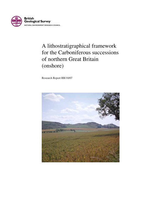
Figure 1 (opposite) principal structural features <strong>of</strong> <strong>the</strong><br />
nor<strong>the</strong>rn British isles, onshore and <strong>of</strong>fshore, that had<br />
significant influence on <strong>the</strong> deposition <strong>of</strong> <strong>Carboniferous</strong><br />
strata. The depositional basins and highs shown are those<br />
that developed during <strong>the</strong> mississippian. Note that some<br />
post-<strong>Carboniferous</strong> structures are shown within <strong>the</strong> North<br />
sea to aid location <strong>of</strong> descriptions in <strong>the</strong> text. North sea<br />
structure is taken from Cameron (1993a and b) and Bruce<br />
and stemmerik (2003). see Figure 2 <strong>for</strong><br />
palaeogeographical reconstructions through time.<br />
BH Bowland High; ClH Central lancashire High; dH<br />
derbyshire High; eG edale Gulf; HB Humber Basin;<br />
ldB lake district Block; mB manx Block; mvs midland<br />
valley <strong>of</strong> scotland.
58°N<br />
54°N<br />
Long<strong>for</strong>d<br />
Down<br />
High<br />
0<br />
IRISH<br />
SEA<br />
N<br />
Firth<br />
<strong>of</strong><br />
Clyde<br />
SOUTHERN UPLAND FAULT<br />
Peel Basin<br />
GREAT GLEN FAULT<br />
100 km<br />
MVS<br />
Sou<strong>the</strong>rn<br />
Uplands<br />
Inner<br />
Moray<br />
Firth<br />
Grampian<br />
Highlands<br />
HIGHLAND BOUNDARY FAULT<br />
Solway Basin<br />
MB<br />
LAMMERMUIR FAULT<br />
Craven<br />
Basin<br />
LDB<br />
PENNINE<br />
FAULTS<br />
3<br />
Forth<br />
Approaches<br />
Basin<br />
Tweed<br />
Basin<br />
Northumberland<br />
Trough<br />
BH<br />
CLH<br />
Holme High<br />
Alston<br />
Block<br />
STUBLICK FAULT<br />
DENT FAULT<br />
Stainmore<br />
Trough<br />
Gainsborough<br />
Trough<br />
DH EG<br />
Widmerpool Gulf<br />
Ha<strong>the</strong>rn Shelf<br />
Land Shelf<br />
Basin<br />
Askrigg<br />
Block<br />
Outer<br />
Moray<br />
Firth<br />
UK CENTRAL<br />
NORTH SEA<br />
Western<br />
High<br />
Mid North<br />
Sea High<br />
UK SOUTHERN<br />
NORTH SEA<br />
Market<br />
Weighton<br />
Block<br />
Cleveland<br />
Basin<br />
FLAMBOROUGH HEAD FAULT<br />
N. CRAVEN<br />
FAULT<br />
MORLEY–CAMPSALL FAULT<br />
East<br />
Midlands<br />
Shelf<br />
4°W Wales–Brabant Massif 0°<br />
HB<br />
Tournaisian–Visean<br />
syn-rift fault<br />
British Geological Survey<br />
Research Report RR/10/07
Uplands<br />
60°N<br />
5°W 0°<br />
5°W 0°<br />
5°W<br />
0°<br />
a) Mid Tournaisian<br />
60°N b) Early Visean<br />
60°N c) Late Visean<br />
(Arundian)<br />
(Brigantian)<br />
Emergent areas<br />
Alluvial<br />
Alluvial<br />
‘Barren Measures’ lith<strong>of</strong>acies<br />
‘Coal Measures’ lith<strong>of</strong>acies<br />
Periodic marine<br />
influence<br />
British Geological Survey<br />
Research Report RR/10/07<br />
V<br />
V<br />
MVS<br />
V<br />
V V<br />
MVS<br />
Alluvial<br />
‘Millstone Grit’ lith<strong>of</strong>acies<br />
SUM<br />
SUM<br />
V<br />
G-MH<br />
CB<br />
DB<br />
NT<br />
AIB<br />
AsB<br />
CB<br />
CLH<br />
V<br />
55°N<br />
NT<br />
CB<br />
55°N<br />
55°N<br />
V<br />
G-MH<br />
Alluvial<br />
AIB<br />
G-MH<br />
‘Yoredale’ and coastal lith<strong>of</strong>acies<br />
M-LD<br />
V<br />
AsB<br />
M-LD<br />
?<br />
V<br />
WT DH<br />
DB<br />
Alluvial<br />
plains<br />
CB<br />
?<br />
Hemipelagic lith<strong>of</strong>acies<br />
V<br />
V<br />
Wales–Brabant<br />
Massif<br />
SB<br />
V<br />
SB<br />
Plat<strong>for</strong>m and ramp carbonate lith<strong>of</strong>acies<br />
Wales–Brabant<br />
Massif<br />
Heterolithic clastic and<br />
nonmarine carbonate lith<strong>of</strong>acies<br />
V<br />
V<br />
V<br />
Continental and peritidal lith<strong>of</strong>acies<br />
50°N<br />
50°N<br />
50°N<br />
Principal direction <strong>of</strong> clastic input<br />
4<br />
0°<br />
60°N<br />
5°W<br />
f) Late Westphalian<br />
(Asturian)<br />
0°<br />
60°N<br />
5°W<br />
e) Early Westphalian<br />
(Langsettian)<br />
0°<br />
60°N<br />
5°W<br />
d) Early Namurian<br />
(Arnsbergian)<br />
Volcanicity<br />
V V V V V<br />
0 150 km<br />
Figure 2 palaeogeographic<br />
reconstructions <strong>for</strong> <strong>the</strong> <strong>Carboniferous</strong> <strong>of</strong><br />
<strong>the</strong> British isles. Adapted from Cope et<br />
al. (1992). AlB Alston Block; AsB<br />
Askrigg Block; CB Craven Basin; CB<br />
Cheviot Block; CuB Culm Basin; dB<br />
dublin Basin; dH derbyshire High;<br />
G–mH Galway–mayo High; lH<br />
leinster High; m–ld manx–lake<br />
district Block; mvs midland valley <strong>of</strong><br />
scotland; NT Northumberland Trough;<br />
sB shannon Basin; sT stainmore<br />
Trough; sum sou<strong>the</strong>rn uplands<br />
massif; wT widmerpool Trough.<br />
V<br />
V<br />
V<br />
V<br />
SUM<br />
55°N<br />
55°N<br />
55°N<br />
G-MH<br />
SUM<br />
Pennine<br />
Basin<br />
Pennine<br />
G-MH<br />
G-MH<br />
V<br />
Basin<br />
Wales–Brabant Massif<br />
Wales–Brabant Massif Wales–Brabant Massif<br />
LH<br />
V<br />
Pennant<br />
CuB<br />
50°N<br />
50°N<br />
50°N
2 Correlation and biostratigraphical <strong>framework</strong><br />
2.1 CHRONOSTRATIGRAPHY<br />
The <strong>Carboniferous</strong> system in western europe comprises<br />
two subsystems, an older dinantian and younger silesian,<br />
traditionally corresponding to lower <strong>Carboniferous</strong><br />
and upper <strong>Carboniferous</strong>, respectively (Table 1). The<br />
dinantian–silesian boundary was chosen to represent<br />
a regional facies transition in Britain from dominantly<br />
carbonate (<strong>Carboniferous</strong> limestone supergroup) to<br />
terrigenous clastic strata and does not reflect a global<br />
change in flora or fauna. The lower boundary <strong>of</strong> <strong>the</strong> silesian<br />
is defined as <strong>the</strong> base <strong>of</strong> <strong>the</strong> ammonoid Cravenoceras leion<br />
Zone.<br />
The terms ‘dinantian’ and ‘silesian’ are now redundant<br />
and <strong>the</strong> mississippian and pennsylvanian <strong>of</strong> <strong>the</strong> usA<br />
have become recognised internationally as <strong>the</strong> only<br />
accepted main divisions (subsystems) <strong>of</strong> <strong>the</strong> <strong>Carboniferous</strong>,<br />
strictly representing <strong>the</strong> lower and upper <strong>Carboniferous</strong>,<br />
respectively, in international usage. The mid <strong>Carboniferous</strong><br />
boundary separating <strong>the</strong> two subsystems occurs within<br />
<strong>the</strong> Chokierian stage <strong>of</strong> <strong>the</strong> Namurian series in western<br />
europe.<br />
difficulties in direct comparison between North<br />
America and western europe have resulted in Britain<br />
maintaining usage <strong>of</strong> <strong>the</strong> regional western european<br />
chronostratigraphical nomenclature. The new, <strong>of</strong>ficial<br />
subdivision <strong>of</strong> <strong>the</strong> <strong>Carboniferous</strong> system, as voted <strong>for</strong> by<br />
<strong>the</strong> subcommission on <strong>Carboniferous</strong> stratigraphy, and<br />
ratified by <strong>the</strong> international Commission on stratigraphy<br />
and <strong>the</strong> international union <strong>of</strong> Geological sciences during<br />
<strong>the</strong> period 1999–2004, has not been applied to this report.<br />
However, <strong>the</strong> reader is referred to davydov et al. (2004) and<br />
Heckel and Clayton (2006) <strong>for</strong> fur<strong>the</strong>r in<strong>for</strong>mation. whilst<br />
<strong>the</strong> authors are fully aware <strong>of</strong> <strong>the</strong> changes to <strong>Carboniferous</strong><br />
stratigraphical nomenclature, <strong>for</strong> sound practical reasons<br />
<strong>the</strong> old style has had to be maintained <strong>for</strong> <strong>the</strong> present.<br />
The dinantian is subdivided into <strong>the</strong> Tournaisian and<br />
visean series, whereas <strong>the</strong> silesian is subdivided into three<br />
series, <strong>the</strong> Namurian, westphalian and stephanian. These<br />
series do not represent global faunal or floral events, but<br />
were chosen to represent prominent facies variations in<br />
western europe. in nor<strong>the</strong>rn Britain, <strong>the</strong> Tournaisian is<br />
dominated by continental and peritidal lith<strong>of</strong>acies, whilst<br />
<strong>the</strong> visean is largely represented in <strong>the</strong> midland valley <strong>of</strong><br />
scotland by heterolithic clastic and nonmarine carbonate<br />
lith<strong>of</strong>acies, and in nor<strong>the</strong>rn england by a mixture <strong>of</strong> open<br />
marine, plat<strong>for</strong>m and ramp carbonates, ‘millstone Grit’ and<br />
‘yoredale’ lith<strong>of</strong>acies. in nor<strong>the</strong>rn Britain <strong>the</strong> Namurian is<br />
dominated by ‘yoredale’ and ‘millstone Grit’ lith<strong>of</strong>acies,<br />
and <strong>the</strong> westphalian is very largely represented by ‘Coal<br />
measures’ lith<strong>of</strong>acies. The base <strong>of</strong> <strong>the</strong> westphalian is taken<br />
at <strong>the</strong> base <strong>of</strong> <strong>the</strong> ammonoid Gastrioceras subcrenatum<br />
Zone, which broadly equates with <strong>the</strong> first incoming <strong>of</strong><br />
thick coal seams. However, G. subcrenatum has not been<br />
found in scotland so <strong>the</strong> base <strong>of</strong> <strong>the</strong> westphalian <strong>the</strong>re<br />
cannot be defined accurately. in scotland <strong>the</strong> base <strong>of</strong> <strong>the</strong><br />
Coal measures is taken at <strong>the</strong> base <strong>of</strong> <strong>the</strong> lowstone marine<br />
Band, its local correlative, or at a plane <strong>of</strong> discon<strong>for</strong>mity.<br />
The stephanian is restricted to strata <strong>of</strong> limited geographical<br />
extent in onshore nor<strong>the</strong>rn Britain.<br />
5<br />
internationally, <strong>the</strong> Tournaisian and visean are now<br />
<strong>for</strong>mally defined as stages, and work is in progress to<br />
define subsequent stages using nomenclatures defined<br />
in Russia. However, until this work is complete it is<br />
considered prudent to maintain usage <strong>of</strong> <strong>the</strong> well-established<br />
chronostratigraphical nomenclatures established in Britain<br />
and western europe.<br />
stage names <strong>for</strong> <strong>the</strong> visean, Namurian and westphalian<br />
are based on basal stratotypes defined by George et al.<br />
(1976) <strong>for</strong> <strong>the</strong> visean, Ramsbottom et al. (1978) <strong>for</strong> <strong>the</strong><br />
Namurian, and owens et al. (1985) <strong>for</strong> <strong>the</strong> westphalian,<br />
largely from localities in nor<strong>the</strong>rn england. The distribution<br />
at outcrop <strong>of</strong> <strong>the</strong> main chronostratigraphical units and <strong>the</strong><br />
location <strong>of</strong> <strong>the</strong> stage stratotypes is shown in Figure 3.<br />
The stephanian series was originally defined in <strong>the</strong><br />
massif Central <strong>of</strong> France with three stages, referred to<br />
as stephanian A, B and C. The stephanian A has been<br />
<strong>for</strong>mally renamed <strong>the</strong> Barruelian stage. The recognition <strong>of</strong><br />
a non-sequence in <strong>the</strong> massif Central and identification <strong>of</strong><br />
an additional stephanian succession in Cantabria, nor<strong>the</strong>rn<br />
spain, led to <strong>the</strong> recognition <strong>of</strong> a Cantabrian stage, which is<br />
older than <strong>the</strong> Barruelian. No strata <strong>of</strong> Cantabrian age have<br />
been recognised in nor<strong>the</strong>rn Britain.<br />
2.2 BIOSTRATIGRAPHY<br />
Ammonoids (goniatites) are crucial to <strong>Carboniferous</strong><br />
biostratigraphy, notably within <strong>the</strong> visean, Namurian and<br />
early westphalian series, where <strong>the</strong>y provide <strong>the</strong> greatest<br />
biostratigraphical resolution. The nektopelagic habit <strong>of</strong><br />
ammonoids allows biozones to be recognised across<br />
western europe and some are applicable globally. Thickshelled<br />
ammonoids occur within thin hemipelagic marine<br />
beds (known as ‘marine bands’), which developed during<br />
marine transgressions and typically comprise distinct<br />
ammonoid faunas. Ammonoid biozones are units defined<br />
by <strong>the</strong> successive first appearance <strong>of</strong> ammonoid taxa,<br />
with <strong>the</strong> base <strong>of</strong> <strong>the</strong> biozones coinciding with <strong>the</strong> bases<br />
<strong>of</strong> specific marine bands (Tables 2, 3 and 4). very little is<br />
known <strong>of</strong> <strong>the</strong> early Courceyan ammonoid faunas in Britain<br />
and ireland, and goniatite occurrences are rare in Britain<br />
in beds older than late visean. diagnostic goniatites are<br />
also uncommon in <strong>the</strong> Namurian <strong>of</strong> nor<strong>the</strong>rn Britain,<br />
though work initiated by Currie (1954) showed that <strong>the</strong><br />
classification <strong>of</strong> <strong>the</strong> pennines area could be applied to<br />
part, at least, <strong>of</strong> <strong>the</strong> scottish succession. Ramsbottom et<br />
al. (1978) applied a standard nomenclature based on <strong>the</strong><br />
names <strong>of</strong> <strong>the</strong> principal diagnostic goniatites <strong>for</strong> <strong>the</strong> six<br />
most important marine bands in <strong>the</strong> coalfields <strong>of</strong> <strong>the</strong> British<br />
isles. Apart from <strong>the</strong> Cambriense marine Band, <strong>the</strong>se<br />
bands can be traced throughout western europe, except in<br />
some marginal areas.<br />
Foraminifers are <strong>of</strong> biostratigraphical importance within<br />
Tournaisian and visean carbonates. They are particularly<br />
abundant in mid-ramp and plat<strong>for</strong>m settings, but also<br />
present within basinal deposits in limestone turbidites<br />
(Riley, 1993). The <strong>for</strong>mal <strong>for</strong>aminiferal zonation <strong>for</strong><br />
Belgium, established as <strong>the</strong> standard <strong>for</strong> north-west europe,<br />
has been applied to British and irish sequences by Conil et<br />
British Geological Survey<br />
Research Report RR/10/07
Table 1 Chronostratigraphical <strong>framework</strong> <strong>for</strong><br />
<strong>the</strong> <strong>Carboniferous</strong> system <strong>of</strong> Great Britain.<br />
Ages derived from menning et al. (2000),<br />
davydov et al. (2004) (<strong>the</strong> dates shown in<br />
brackets are international stage boundary<br />
determinations from Gradstein and ogg, 2004);<br />
<strong>Carboniferous</strong> chronostratigraphy from Heckel<br />
and Clayton (2006); seismic sequences from<br />
Fraser et al. (1990); meso<strong>the</strong>ms from<br />
Ramsbottom (1973, 1977a).<br />
British Geological Survey<br />
Research Report RR/10/07<br />
Age<br />
(Ma)<br />
299<br />
(299.0 ± 0.8)<br />
(303.9 ± 0.9)<br />
(306.5 ± 1.0)<br />
310<br />
(311.7 ± 1.1)<br />
(318.1 ± 1.3)<br />
320<br />
330<br />
340<br />
(345.3 ± 2.1)<br />
350<br />
359<br />
(359.2 ± 2.5)<br />
6<br />
International<br />
Series<br />
KASIM-<br />
OVIAN<br />
PENNSYLVANIAN<br />
MISSISSIPPIAN<br />
International<br />
Stages<br />
GZHELIAN<br />
MOSCOVIAN<br />
BASHKIRIAN<br />
SERPUKHOVIAN<br />
VISEAN<br />
TOURNAISIAN<br />
European<br />
Subperiods<br />
European Stages<br />
(<strong>for</strong>mer Series)<br />
Heerlen<br />
Classification<br />
SILESIAN (UPPER CARBONIFEROUS)<br />
DINANTIAN (LOWER CARBONIFEROUS)<br />
STEPHANIAN<br />
WESTPHALIAN<br />
NAMURIAN<br />
VISEAN<br />
TOURNAISIAN<br />
C<br />
B<br />
A<br />
D<br />
C<br />
BARRUELIAN<br />
CANTABRIAN<br />
ASTURIAN<br />
BOLSOVIAN<br />
B DUCKMANTIAN<br />
A LANGSETTIAN<br />
C YEADONIAN<br />
MARSDENIAN<br />
B<br />
KINDERSCOUTIAN<br />
ALPORTIAN<br />
CHOKIERIAN<br />
A<br />
ARNSBERGIAN<br />
PENDLEIAN<br />
V3c BRIGANTIAN<br />
V3b ASBIAN<br />
V3a<br />
V2b<br />
V2a<br />
V1b<br />
V1a<br />
European Substages<br />
(<strong>for</strong>mer Stages)<br />
HOLKERIAN<br />
ARUNDIAN<br />
CHADIAN<br />
IVORIAN<br />
HASTARIAN<br />
COURCEYAN<br />
Seismic<br />
Stratigraphy<br />
V1<br />
LC2<br />
LC1<br />
EC6<br />
EC5<br />
EC4<br />
EC3<br />
EC2<br />
EC1<br />
Meso<strong>the</strong>ms<br />
N11<br />
N9–10<br />
N6–8<br />
N5<br />
N4<br />
N3<br />
N2<br />
N1<br />
D6b<br />
D6a<br />
D5b<br />
D5a<br />
D4<br />
D3<br />
D2b<br />
D2a<br />
D1c<br />
D1b<br />
D1a
Ayrshire<br />
Mochrihanish<br />
Arran<br />
Sanquhar<br />
Basin<br />
54°N<br />
Thornhill<br />
Basin<br />
Isle <strong>of</strong> Man<br />
Solway<br />
Basin<br />
Volcanic rocks Warwickshire Group<br />
Coal Measures groups<br />
North Cumbria<br />
Central Coalfield Basin<br />
CHAPTER 4: MIDLAND VALLEY OF SCOTLAND<br />
CHAPTER 5:<br />
This report covers<br />
<strong>the</strong> area north <strong>of</strong><br />
this line<br />
SOUTHERN UPLANDS<br />
West<br />
Cumbria<br />
Craven<br />
Basin<br />
S. Cumbria<br />
Furness &<br />
Cartmel<br />
al. (1980) and Conil et al. (1991) and is summarised in<br />
Table 2.<br />
Conodonts are present within marine facies, notably<br />
carbonate turbidites and hemipelagic shales, and conodont<br />
zones are particularly important <strong>for</strong> Tournaisian and visean<br />
correlation. varker and sevastopulo (1985) included<br />
zonations <strong>for</strong> both ‘shelf margin and basin facies’ and<br />
‘shelf facies’. Conodonts are also important in recognising<br />
<strong>the</strong> mid <strong>Carboniferous</strong> boundary and <strong>the</strong> base <strong>of</strong> <strong>the</strong><br />
pennsylvanian subsystem.<br />
palynomorphs (miospores) are present in both marine<br />
and terrestrial environments and have been used <strong>for</strong><br />
biozonation up to and including <strong>the</strong> Asturian (westphalian<br />
d) (Tables 2, 3 and 4). They are particularly useful<br />
<strong>for</strong> facilitating correlation in nonmarine rocks lacking<br />
stratigraphically useful macr<strong>of</strong>ossils, and <strong>the</strong>y can be used to<br />
correlate between nonmarine and marine sequences. Recent<br />
Namurian strata<br />
7<br />
Fife-Lothian Basin<br />
Tweed Basin<br />
CHAPTER 6:<br />
NORTHERN<br />
ENGLAND<br />
Cheviot Block / North-east<br />
Northumberland<br />
Northumberland Trough<br />
Alston Block<br />
4°W 0°<br />
Stainmore Trough<br />
Askrigg Block<br />
Tournaisian and Visean strata<br />
Regions covered by named<br />
chapters<br />
Figure 3 extent <strong>of</strong> <strong>Carboniferous</strong> rocks <strong>of</strong> onshore nor<strong>the</strong>rn Great Britain. The approximate area covered by<br />
this report is indicated as is <strong>the</strong> location <strong>of</strong> regions discussed in <strong>the</strong> various chapters in <strong>the</strong> text.<br />
advances in macr<strong>of</strong>loral zonation show <strong>the</strong> importance <strong>of</strong><br />
plant fossil biostratigraphy, particularly <strong>for</strong> <strong>the</strong> Asturian<br />
(westphalian d) and Cantabrian (Cleal, 1991).<br />
Coral/brachiopod biozonation has been <strong>of</strong> historical<br />
importance in <strong>the</strong> classification <strong>of</strong> Tournaisian and visean<br />
plat<strong>for</strong>m carbonates, though <strong>the</strong>y are now considered strongly<br />
facies controlled. However, <strong>the</strong> zonation nomenclature <strong>of</strong><br />
vaughan (1905) <strong>for</strong> Bristol and south wales and Garwood<br />
(1913) is still widely used and was summarised by George<br />
et al. (1976) and Riley (1993). Riley (1993, fig. 1) showed<br />
<strong>the</strong> interrelationship between <strong>the</strong> coral/brachiopod zones<br />
<strong>of</strong> vaughan (1905) and <strong>the</strong> modified conodont zones <strong>of</strong><br />
varker and sevastopulo (1985) and <strong>the</strong> relationship <strong>of</strong> <strong>the</strong>se<br />
and o<strong>the</strong>r zones to <strong>the</strong> <strong>for</strong>mer stages (now partly redefined<br />
substages) <strong>of</strong> <strong>the</strong> Tournaisian and visean.<br />
in <strong>the</strong> visean to Namurian, marine bivalves present<br />
within hemipelagic shales and occurring in association<br />
0<br />
N<br />
100 km<br />
British Geological Survey<br />
Research Report RR/10/07
Table 2 Tournaisian and visean biostratigraphical zonations, derived from Riley (1993). Grey shading<br />
indicates interzones (conodonts and miospores) or non-sequences (brachiopods). anch. bis.<br />
Scaliognathus anchoralis — Polygnathus bisch<strong>of</strong>fi; Arnsb. Arnsbergites; B. Bollandoceras; bouc.<br />
Dollymae bouckaerti; bul. Eotaphrus bultyncki; bur. Eotaphrus burlingtonensis; C. Caninophyllum; coll.<br />
Gnathodus girtyi collinsoni; G. Goniatites; Gn. Gnathodus; has. Dollymae hassi; hom. Gnathodus<br />
homopunctatus; in. Polygnathus inornatus/Siphonodella; L. Lochriea; lat. Doliognathus latus; Lusit.<br />
Lusitanoceras; Lyrog. Lyrogoniatites; mono. mononodosa; Neoglyph. Neoglyphioceras; Parag.<br />
Paraglyphioceras; prae. Mestognathus praebeckmanni; Ps. Pseudopolygnathus; S. Siphonophyllia; Siph.<br />
Siphonodella; spic. Polygnathus spicatus; V. Vaughania; Z. Zaphrentis.<br />
Stages<br />
Visean<br />
Tournaisian (part)<br />
Substages<br />
Brigantian<br />
Asbian<br />
Holkerian<br />
Arundian<br />
Chadian<br />
late<br />
early<br />
Courceyan<br />
Gn.collinsoni Lyrog. georgiensis P2c<br />
L. mono<br />
Neoglyph. subcirculareP2b<br />
Lusit. granosus P2a<br />
Parag. koboldi<br />
Parag. elegans<br />
P1d<br />
P1c<br />
Gn.bilineatus Arnsb. falcatus P1b<br />
G. crenistria P1a<br />
G. globostriatus B2b<br />
G. hudsoni B2a<br />
L. commutata<br />
prae.<br />
anch.<br />
bis<br />
bur.<br />
lat.<br />
bul. bouc.<br />
Polygnathus mehli<br />
cf.<br />
has.<br />
bul.<br />
Ps.<br />
multistriatus<br />
Siph.<br />
Conodonts<br />
hom.<br />
spic. in.<br />
Beyrichoceras<br />
with ammonoids are <strong>of</strong> greatest stratigraphical importance<br />
(Riley, 1993). However, this lith<strong>of</strong>acies is unknown in <strong>the</strong><br />
midland valley <strong>of</strong> scotland and is very rare in nor<strong>the</strong>rn<br />
england. in <strong>the</strong> <strong>for</strong>mer region, <strong>the</strong> relatively diverse<br />
molluscan fauna is considered and treated as part <strong>of</strong> <strong>the</strong> total<br />
assemblage <strong>of</strong> macr<strong>of</strong>ossils in marine facies.<br />
Nonmarine bivalves are fundamentally important to <strong>the</strong><br />
British Geological Survey<br />
Research Report RR/10/07<br />
Ammonoids<br />
B1<br />
B. hodderense<br />
Bollandites-<br />
Bollandoceras<br />
BB<br />
Fascipericyclus-<br />
Ammonellipsites<br />
FA<br />
Pericyclus<br />
Gattendorfia<br />
Foraminifera<br />
Neoarchaediscus Cf6 (part)<br />
Koskinotextularia-<br />
Pojarkovella nibelis<br />
Cf5<br />
Eoparastaffella Cf4<br />
Tetrataxis-<br />
Eotextularia<br />
Cf3<br />
Paraendothyra<br />
Cf2<br />
Chernyshinella<br />
Cf1<br />
<br />
<br />
<br />
<br />
<br />
<br />
2<br />
Mitchell<br />
(1981, 1989)<br />
K<br />
J<br />
I<br />
H<br />
G<br />
F<br />
E<br />
D<br />
C<br />
B<br />
A<br />
S.<br />
cylindrica<br />
1<br />
C.<br />
patulum<br />
Coral / brachiopod<br />
Z. delanouei<br />
V. vetus<br />
Vaughan<br />
(1905)<br />
Horizon<br />
E<br />
D2<br />
D1<br />
S2 (part)<br />
8<br />
D<br />
D2<br />
D1<br />
S2<br />
S2 (part)<br />
S1 S1<br />
C2 (part)<br />
C2<br />
C2 (part)<br />
C1<br />
Z<br />
K<br />
M<br />
Garwood<br />
(1913)<br />
C2 (part)<br />
C1<br />
Z?<br />
Miospores<br />
NC<br />
(part)<br />
VF<br />
NM<br />
TC<br />
TS<br />
Pu<br />
CM<br />
PC<br />
BP<br />
HD<br />
VI<br />
Macr<strong>of</strong>lora<br />
Lyginopteris bermudensi<strong>for</strong>mis / Neuropteris antecedens<br />
Triphyllopteris<br />
'Adianites'<br />
zonation <strong>of</strong> late Namurian and westphalian sequences in<br />
<strong>the</strong> midland valley <strong>of</strong> scotland and <strong>the</strong> Northumberland<br />
Trough (Table 4). They tend to occur in association with<br />
fish material and ostracods.<br />
es<strong>the</strong>riids are small crustaceans that occupied brackish<br />
waters. They can occur in prominent marker ‘bands’ in <strong>the</strong><br />
westphalian.
Table 3 summary <strong>of</strong> <strong>the</strong> chronostratigraphical units <strong>of</strong> <strong>the</strong> Namurian and <strong>the</strong> main biozones <strong>for</strong> <strong>the</strong><br />
most important fossil groups.<br />
EUROPEAN<br />
REGIONAL<br />
SUBSTAGE<br />
yeadonian<br />
marsdenian<br />
Kinderscoutian<br />
Alportian<br />
Chokierian<br />
Arnsbergian<br />
pendleian<br />
ZONE<br />
WESTERN EUROPEAN<br />
MARINE BANDS<br />
Index Ammonoid Ammonoid Index (Index)<br />
G 1b<br />
G 1a<br />
R 2c<br />
R 2b<br />
Cancelloceras<br />
cumbriense<br />
Cancelloceras<br />
cancellatum<br />
Bilinguites<br />
superbilinguis<br />
Bilinguites bilinguis<br />
Ca. cumbriense G 1b 1<br />
Ca. cancellatum G 1a 1<br />
Verneulites sigma R2c2 B. superbilinguis R2c1 B. metabilinguis R2b5 B.eometabilinguis R2b4 B. bilinguis R2b3 B. bilinguis R2b2 B. bilinguis R2b1 R 2a Bilinguites gracilis B. gracilis R 2a 1<br />
R 1c<br />
R 1b<br />
R 1a<br />
Reticuloceras<br />
reticulatum<br />
Reticuloceras<br />
eoreticulatum<br />
Hodsonites<br />
magistrorum<br />
R. coreticulatum R1c4 R. reticulatum R1c3 R. reticulatum R1c2 R. reticulatum R 1c 1<br />
R. stubblefieldi R1b3 R. nodosum R1b2 R. eoreticulatum R1b1 R. dubium R1a5 R. todmordenense R1a4 R. subreticulatum R1a3 R. circumplicatile R1a2 Ho. magistrorum R 1a 1<br />
H2c Vallites eostriolatus<br />
Homoceratoides<br />
prereticulatus<br />
V. eostriolatus<br />
H2c2 H2c1 H2b Homoceras undulatum H. undulatum H2b1 H 2a Hudsonoceras proteum Hd. proteum H 2a 1<br />
H 1b<br />
H 1a<br />
e 2c<br />
e 2b<br />
e 2a<br />
e 1c<br />
Homoceras<br />
beyrichianum<br />
Isohomoceras<br />
subglobosum<br />
Nuculoceras stellarum<br />
Cravenocera–toides<br />
edalensis<br />
Cravenoceras<br />
cowlingense<br />
Cravenoceras<br />
malhamense<br />
I. sp. nov. H1b2 H. beyrichianum H1b1 I. subglobosum H1a3 I. subglobosum H1a2 I. subglobosum H1a1 N. nuculum e2c4 N. nuculum e2c3 N. nuculum e2c2 N. stellarum e2c1 Ct. nititoides e2b3 Ct. nitidus e2b2 Ct. edalensis e2b1 Eumorphoceras yatesae e2a3 C. gressinghamense e2a2a Eumorphoceras<br />
ferrimontanum<br />
e2a2 C. cowlingense e2a1 9<br />
MIOSPORES CONODONTS<br />
Raistrickia fulva –<br />
Reticulatisporites<br />
reticulatus<br />
(FR)<br />
Crassispora kosankei –<br />
Grumosisporites<br />
varioreticulatus<br />
(Kv)<br />
Lycospora subtriquetra<br />
– Kraeuselisporites<br />
ornatus<br />
(so)<br />
C. malhamense e 1c 1 Bellispores<br />
nitidus –<br />
e1b Cravenoceras brandoni Tumulites pseudobilinguis e1b2 C. brandoni e1b1 e1a Emstites (Cravenoceras)<br />
leion<br />
E. leion e1a1 Lycospora subtriquetra<br />
– Kraeuselisporites<br />
ornatus<br />
(so)<br />
Stenzonotriletes<br />
triangulus – Rotaspora<br />
knoxi<br />
(TK)<br />
Reticulatisporites<br />
carnosus<br />
(NC)<br />
pars.<br />
Idiognathoides<br />
sinuatus –<br />
Idiognathoides<br />
primulus<br />
Idiognathoides<br />
corrugatus –<br />
Idiognathoides<br />
sulcatus<br />
Declinognathus<br />
noduliferus<br />
Gnathodus bilineatus<br />
bollandensis<br />
Kladognathus<br />
– Gnathodus girtyi<br />
simplex<br />
British Geological Survey<br />
Research Report RR/10/07
Table 4 westphalian chronostratigraphy and biostratigraphical zonations.<br />
European<br />
Regional<br />
Substage<br />
Cantabrian<br />
British Geological Survey<br />
Research Report RR/10/07<br />
Ammonoids Conodonts<br />
Donetzoceras<br />
Asturian cambriense<br />
oT<br />
Bolsovian<br />
duckmantian<br />
langsettian<br />
Donetzoceras<br />
aegiranum<br />
Anthracoceratites<br />
vanderbeckei<br />
Gastrioceras<br />
listeri<br />
Gastrioceras<br />
subcrenatum<br />
Idiognathoides<br />
sulcatus parvus<br />
Idiognathoides<br />
sinuatus –<br />
Idiognathoides<br />
primulus (pars.)<br />
10<br />
Palynomorphs Non-marine bivalves<br />
Index Zone Zone Sub-zone<br />
sl<br />
NJ<br />
RA<br />
ss<br />
Thymospora<br />
obscura –<br />
T. thiessenii<br />
Torispora<br />
securis –<br />
T. laevignata<br />
Microreticulati-<br />
sporites nobilis –<br />
Florinites junior<br />
Radiizonates<br />
aligerens<br />
Triquitrites<br />
sinani-<br />
Cirratriradites<br />
saturni<br />
Anthraconauta<br />
tenuis<br />
Anthraconauta<br />
phillipsii<br />
‘Upper<br />
similis- pulchra’<br />
‘Lower<br />
similis-pulchra’<br />
Anthraconaia<br />
modiolaris<br />
Carbonicola<br />
communis<br />
Carbonicola<br />
lenisulcata<br />
adamsi-hindi<br />
atra<br />
caledonica<br />
phrygiana<br />
ovum<br />
regularis<br />
cristagalli<br />
pseudorobusta<br />
bipennis<br />
torus<br />
proxima<br />
extenuata<br />
fallax-protea
3 <strong>lithostratigraphical</strong> <strong>framework</strong><br />
The plethora <strong>of</strong> local group and <strong>for</strong>mation names and <strong>the</strong><br />
inconsistent application <strong>of</strong> <strong>lithostratigraphical</strong> hierarchies<br />
<strong>for</strong> <strong>the</strong> <strong>Carboniferous</strong> has, to an extent, hindered <strong>the</strong><br />
regional understanding <strong>of</strong> <strong>the</strong> <strong>Carboniferous</strong> <strong>successions</strong> <strong>of</strong><br />
Great Britain.<br />
From an early, relatively simple <strong>framework</strong>, subsequent<br />
surveys and publications have greatly added to <strong>the</strong> complexity<br />
<strong>of</strong> <strong>the</strong> nomenclature. much <strong>of</strong> this existing nomenclature has<br />
evolved from work carried out long be<strong>for</strong>e guidance was<br />
available <strong>for</strong> best practice in <strong>lithostratigraphical</strong> procedures<br />
(Rawson et al., 2002). Consequently, a haphazard approach<br />
to <strong>the</strong> establishment <strong>of</strong> <strong>the</strong> hierarchy <strong>of</strong> units has resulted.<br />
The local nomenclatures can be attributed to <strong>the</strong><br />
following:<br />
• restriction <strong>of</strong> deposits to individual basins<br />
• isolation by faulting or erosion <strong>of</strong> once laterally<br />
contiguous deposits following end <strong>Carboniferous</strong> and<br />
subsequent tectonic events<br />
• <strong>the</strong> <strong>for</strong>mer BGS methodology <strong>of</strong> mapping geological<br />
sheets in isolation<br />
• where a <strong>for</strong>mal <strong>lithostratigraphical</strong> nomenclature has<br />
not been defined on BGs maps, scientific publications<br />
have created <strong>the</strong>ir own, commonly conflicting,<br />
schemes.<br />
The Geological society special Reports <strong>for</strong> <strong>the</strong> dinantian<br />
and silesian (George et al., 1976; Ramsbottom et al.,<br />
1978) provided useful stratigraphical correlations between<br />
key sections across <strong>the</strong> British isles. However, <strong>the</strong> reports<br />
did not give a unified <strong>lithostratigraphical</strong> <strong>framework</strong>.<br />
Their preference was to promote a unified approach to<br />
lithostratigraphy, biostratigraphy and chronostratigraphy<br />
(Holland et al., 1978, p. 4).<br />
in order to review <strong>the</strong> existing nomenclature it was<br />
decided to follow <strong>the</strong> guidance <strong>of</strong> <strong>the</strong> North American<br />
stratigraphic Code (NAsC) (Anon., 1983) and more<br />
recently, Geological society <strong>of</strong> london guidance (Rawson<br />
et al., 2002), as <strong>the</strong>se are commonly accepted standards.<br />
The nomenclature chosen should aid communication <strong>of</strong><br />
British <strong>Carboniferous</strong> geology to o<strong>the</strong>rs. However, it is<br />
acknowledged that many names are so entrenched in <strong>the</strong><br />
literature that <strong>the</strong>ir replacement would result in confusion.<br />
As a consequence, this report uses existing nomenclature<br />
where suitable, whilst providing full definitions consistent<br />
with <strong>the</strong> guidance from <strong>the</strong> NAsC and <strong>the</strong> Geological<br />
society <strong>of</strong> london.<br />
An alphabetical listing <strong>of</strong> all <strong>the</strong> groups and <strong>for</strong>mations<br />
present within nor<strong>the</strong>rn Britain are provided in Appendix<br />
1. Redundant or obsolete names are listed in Appendix 3.<br />
3.1 GROUP FRAMEWORK<br />
in rationalising <strong>the</strong> stratigraphy it was decided to follow<br />
a ‘top-down’ approach by which <strong>the</strong> group nomenclature<br />
was based upon <strong>the</strong> recognition <strong>of</strong> major lith<strong>of</strong>acies.<br />
The committee considered <strong>the</strong> possibility <strong>of</strong> having a<br />
single group name <strong>for</strong> each lith<strong>of</strong>acies applicable to all<br />
Great Britain. However, <strong>the</strong> lith<strong>of</strong>acies were commonly<br />
11<br />
developed within distinct basinal areas and a single Britainwide<br />
group nomenclature would not aid <strong>the</strong> understanding<br />
<strong>of</strong> <strong>the</strong> evolution <strong>of</strong> <strong>the</strong> basins. Hence, it was agreed<br />
that separate group names should be employed <strong>for</strong> each<br />
distinct depositional area. where it was believed useful to<br />
provide a single term <strong>for</strong> a Britain-wide lith<strong>of</strong>acies, it was<br />
recommended it should be defined as a supergroup.<br />
Nine major lith<strong>of</strong>acies associations (Figure 4) have been<br />
identified <strong>for</strong> <strong>the</strong> <strong>Carboniferous</strong> <strong>of</strong> onshore Great Britain,<br />
all <strong>of</strong> which are recognised in <strong>the</strong> nor<strong>the</strong>rn provinces. The<br />
main lithologies, environments <strong>of</strong> deposition, distribution<br />
and age ranges were first described by waters et al. (2007;<br />
see also Figure 2).<br />
A continental and peritidal facies is widespread across<br />
nor<strong>the</strong>rn Britain including from <strong>the</strong> midland valley <strong>of</strong><br />
scotland to central england. it was deposited from late<br />
devonian to visean times. There are two subfacies, which are<br />
commonly found to interdigitate. A continental fluvioclastic<br />
(‘cornstone’) subfacies commonly <strong>for</strong>ms <strong>the</strong> first basin infill<br />
and extends onto horst and tilt-block highs. A peritidal marine<br />
and evaporite (‘cementstone’) subfacies is generally limited<br />
to troughs associated with grabens and half-grabens.<br />
A heterolithic clastic and nonmarine carbonate facies, <strong>of</strong><br />
visean age, is principally present in <strong>the</strong> eastern part <strong>of</strong> <strong>the</strong><br />
midland valley <strong>of</strong> scotland where it passes laterally westward<br />
into dominantly volcanic rocks. it is also present as<br />
early visean strata in parts <strong>of</strong> <strong>the</strong> Northumberland Trough.<br />
An open marine, plat<strong>for</strong>m and ramp carbonates facies<br />
accumulated during <strong>the</strong> visean on plat<strong>for</strong>ms and ramps that<br />
developed on horst blocks and half-graben tilt blocks over<br />
<strong>the</strong> Alston and Askrigg blocks, and fringing <strong>the</strong> manx–lake<br />
district Block.<br />
A hemipelagic facies was deposited in quiet and relatively<br />
deep basinal prodelta and carbonate slope environments<br />
that developed in <strong>the</strong> Furness and Cartmell area (south<br />
Cumbria) and <strong>the</strong> Askrigg Block–Craven Basin ‘Transition<br />
Zone’ during <strong>the</strong> early Namurian.<br />
A mixed shelf carbonate and deltaic (‘Yoredale’) facies<br />
is widespread across <strong>the</strong> midland valley <strong>of</strong> scotland and<br />
nor<strong>the</strong>rn england as far south as <strong>the</strong> Craven Fault system.<br />
it is found in strata <strong>of</strong> visean to Namurian age.<br />
A fluviodeltaic (‘Millstone Grit’) facies extends from<br />
<strong>the</strong> midland valley <strong>of</strong> scotland, across nor<strong>the</strong>rn and central<br />
england in strata <strong>of</strong> Namurian to early westphalian<br />
age. similar deposition may have occurred within <strong>the</strong><br />
Northumberland Trough during early visean times.<br />
A fluviodeltaic (‘Coal Measures’) facies extends from<br />
<strong>the</strong> midland valley <strong>of</strong> scotland across nor<strong>the</strong>rn england in<br />
strata <strong>of</strong> westphalian age.<br />
An alluvial (‘Barren Measures’) facies occurs as two<br />
subfacies in Britain (see waters et al., 2007). However, only<br />
<strong>the</strong> ‘red-bed’ subfacies occurs in nor<strong>the</strong>rn Britain in west<br />
Cumbria, <strong>the</strong> ingleton Coalfield and <strong>the</strong> solway Basin. it<br />
was deposited during <strong>the</strong> westphalian.<br />
A volcanic facies is most thickly present as <strong>the</strong> Clyde<br />
plateau volcanic Formation (Arundian to Asbian) and<br />
Bathgate Group (Asbian to Arnsbergian) <strong>of</strong> <strong>the</strong> midland<br />
valley <strong>of</strong> scotland, but it is also significantly developed<br />
in <strong>the</strong> Tournaisian and visean age rocks <strong>of</strong> <strong>the</strong> solway and<br />
Tweed basins (Cockermouth, Birrenswark and Kelso vol-<br />
British Geological Survey<br />
Research Report RR/10/07
Principal lith<strong>of</strong>acies<br />
Volcanic lith<strong>of</strong>acies<br />
Barren Measures<br />
lith<strong>of</strong>acies<br />
Coal Measures lith<strong>of</strong>acies<br />
Millstone Grit lith<strong>of</strong>acies<br />
Yoredale lith<strong>of</strong>acies<br />
Hemipelagic lith<strong>of</strong>acies<br />
Plat<strong>for</strong>m/ramp carbonate<br />
lith<strong>of</strong>acies<br />
Heterolithic clastic and<br />
nonmarine carbonate<br />
lith<strong>of</strong>acies<br />
Continental and peritidal<br />
lith<strong>of</strong>acies<br />
Mudstone/siltstone<br />
British Geological Survey<br />
Research Report RR/10/07<br />
Grain size<br />
C SI FS CS Gr Cg<br />
Sandstone Dolostone<br />
Coal<br />
y<br />
y<br />
y<br />
y<br />
/ \<br />
/ \<br />
Description <strong>of</strong> principal lithologies<br />
Lava, tuff, tuffite, volcaniclastic sedimentary rocks and boles (fossil<br />
soils)<br />
Red, brown or purple-grey mudstone, siltstone, sandstone,<br />
conglomerate and breccia; minor coal, ‘Spirorbis limestone’<br />
and calcrete. Also, grey sandstone to granulestone with subordinate<br />
grey mudstone and thin coal seams<br />
Black and grey mudstone, siltstone and sandstone, with common<br />
seatearth, thick coal seams and ironstone. Marine shale and o<strong>the</strong>r<br />
fossiliferous beds (’bands’), including those with nonmarine<br />
bivalves (’mussels’), Lingula and Planolites, may occur.<br />
Black and grey mudstone, siltstone and sandstone, with subordinate<br />
seatearth and thin coal seams, typically in upward-coarsening cycles<br />
Grey mudstone, siltstone, sandstone and marine limestone with<br />
subordinate seatearth and coal seams, typically in upward-coarsening<br />
cycles<br />
Dark grey to black mudstone with thin sandstone or marine limestone<br />
beds; subordinate breccia; sand- and carbonate-rich turbidite<br />
Blanket bioclastic carbonate, locally ooidal with common karstic<br />
bedding surfaces, or calcareous mudstone and bioclastic<br />
limestone, locally with mud mounds and patch reefs<br />
Grey sandstone, siltstone, mudstone and locally oil shale, with<br />
subordinate beds <strong>of</strong> lacustrine and some marine limestone and<br />
dolostone, coal, seatearth and ironstone<br />
Purple-red conglomerate, sandstone, siltstone and mudstone with<br />
nodules and thin beds <strong>of</strong> calcrete, or grey mudstone, siltstone and<br />
sandstone with dolostone, gypsum and anhydrite beds<br />
Lithology Sedimentary structures<br />
Limestone Cross-lamination<br />
Volcaniclastic<br />
12<br />
Planar lamination<br />
Rooted<br />
Mud mound<br />
Marine shale Lava Cross-bedding Calcrete<br />
y<br />
/ \<br />
/ \<br />
Mudstone intraclast<br />
Ooids<br />
Pebbles
canic <strong>for</strong>mations), in <strong>the</strong> Namurian <strong>of</strong> <strong>the</strong> western midland<br />
valley (Troon volcanic member) and in Namurian to<br />
westphalian rocks <strong>of</strong> <strong>the</strong> eastern midland valley.<br />
it will be noted in <strong>the</strong> report that some groups designated<br />
in nor<strong>the</strong>rn Britain may comprise two or more lith<strong>of</strong>acies<br />
associations (excluding volcanics). For example, in <strong>the</strong> case<br />
<strong>of</strong> <strong>the</strong> Clackmannan Group <strong>of</strong> scotland, this resulted from<br />
a desire not to have a large number <strong>of</strong> single-<strong>for</strong>mation<br />
groups where several main lith<strong>of</strong>acies are represented, and<br />
in <strong>the</strong> case <strong>of</strong> <strong>the</strong> yoredale Group <strong>of</strong> nor<strong>the</strong>rn england it<br />
dealt with local variances in <strong>the</strong> main lith<strong>of</strong>acies.<br />
3.2 FORMATION FRAMEWORK<br />
in most cases a nomenclature <strong>of</strong> <strong>for</strong>mations, and to a lesser<br />
extent members, has been established. Those <strong>for</strong>mations<br />
present within areas <strong>of</strong> recent geological resurvey already<br />
have a full <strong>for</strong>mal <strong>lithostratigraphical</strong> description, which<br />
is replicated in this report. in some circumstances, <strong>the</strong><br />
definition <strong>of</strong> existing <strong>for</strong>mations has been revised, with <strong>the</strong><br />
new definition reproduced in this report. some <strong>for</strong>mations<br />
have been redefined as a group or member. elsewhere, it<br />
was decided that <strong>the</strong>re was a requirement to rationalise<br />
several local <strong>for</strong>mation names into a single unit. in <strong>the</strong>se<br />
circumstances <strong>the</strong> new <strong>for</strong>mation names generally utilise an<br />
existing, widely used name, which con<strong>for</strong>ms to <strong>the</strong> NAsC<br />
criteria (Anon., 1983). in relatively few cases, <strong>for</strong>mation<br />
names did not exist and new terms have been introduced as<br />
part <strong>of</strong> this study.<br />
A <strong>for</strong>mation is a mappable unit that possesses internal<br />
lithological homogeneity or distinctive lithological features<br />
Figure 4 (Opposite) schematic graphic log summarising<br />
<strong>the</strong> nine main lith<strong>of</strong>acies. Although <strong>the</strong> lith<strong>of</strong>acies are shown<br />
broadly in <strong>the</strong>ir order <strong>of</strong> superposition, youngest at <strong>the</strong> top,<br />
<strong>the</strong>y may interdigitate. The bases <strong>of</strong> <strong>the</strong> beds as shown are<br />
also highly schematic. C claystone; sl siltstone;Fs finegrained<br />
sandstone; Cs coarse-grained sandstone; Gr<br />
granulestone; Cg conglomerate.<br />
13<br />
that distinguish it from adjacent <strong>for</strong>mations (see Rawson<br />
et al., 2002; Anon., 2005 <strong>for</strong> a full definition). individual<br />
coals, sandstones and limestones, whilst <strong>the</strong>y may be ‘mappable<br />
units’ are treated as beds <strong>of</strong> in<strong>for</strong>mal level and are<br />
not described in this report. some limestones within <strong>the</strong><br />
yoredale Group were considered to be amalgamated units<br />
<strong>of</strong> great lateral extent that warranted member status.<br />
The text in this report is largely based on entries in <strong>the</strong><br />
BGs lexicon <strong>of</strong> Named Rock units <strong>for</strong> which lithological<br />
in<strong>for</strong>mation has been compiled from many different sources<br />
using different classifications. where possible, limestone<br />
nomenclature uses <strong>the</strong> dunham (1962) scheme based on<br />
texture, modifying o<strong>the</strong>r terminologies where obvious.<br />
o<strong>the</strong>rwise <strong>the</strong> Folk (1959; 1962) scheme, based mainly on<br />
composition, has been used.<br />
where possible, <strong>the</strong> nomenclature used <strong>for</strong> all igneous<br />
and sedimentary rock names follows <strong>the</strong> recommendations<br />
<strong>of</strong> <strong>the</strong> BGs Rock Classification scheme (RCs). However,<br />
in some circumstances it has been necessary to use <strong>the</strong><br />
original descriptions and ‘legacy’ names.<br />
where relevant, <strong>the</strong> classification <strong>of</strong> basaltic rock in <strong>the</strong><br />
midland valley <strong>of</strong> scotland devised by macGregor (1928)<br />
is included to permit comparison with previous maps and<br />
literature. To avoid repetition <strong>the</strong> six classes are listed here<br />
with <strong>the</strong>ir RCs-compatible translations <strong>for</strong> reference:<br />
Markle: plagioclase-macrophyric basalt to trachybasalt<br />
(hawaiite)<br />
Dunsapie: olivine-clinopyroxene-plagioclase-macrophyric<br />
basalt<br />
Craiglockhart: olivine-clinopyroxene-macrophyric basalt<br />
to basanite (referred to <strong>for</strong>merly as ankaramite)<br />
Jedburgh: plagioclase-microphyric basalt to trachybasalt<br />
(hawaiite)<br />
Dalmeny: olivine-microphyric basalt<br />
Hillhouse: olivine-clinopyroxene-microphyric basalt to<br />
basanite.<br />
These translations are compatible with <strong>the</strong> approach to<br />
rock classification and nomenclature set out in <strong>the</strong> BGs<br />
Rock Classification scheme (volume 1 igneous rocks) by<br />
Gillespie and styles (1999).<br />
British Geological Survey<br />
Research Report RR/10/07
4 <strong>Carboniferous</strong> rocks <strong>of</strong> scotland north <strong>of</strong> <strong>the</strong> sou<strong>the</strong>rn<br />
upland Fault<br />
4.1 MIDLAND VALLEY OF SCOTLAND<br />
The group and <strong>for</strong>mation nomenclature <strong>for</strong> <strong>the</strong> midland<br />
valley <strong>of</strong> scotland proposed by Browne et al. (1999) has<br />
been retained. There are four main groups, in ascending<br />
order, <strong>the</strong> inverclyde (partly devonian in age), strathclyde,<br />
Clackmannan and scottish Coal measures groups (Figure 5;<br />
see also Figure 6). The boundaries between <strong>the</strong> youngest<br />
three groups are defined by marker horizons that are<br />
widespread within <strong>the</strong> midland valley. volcanic rocks are<br />
common, ranging from thin local beds to widespread thick<br />
accumulations. The major occurrences <strong>of</strong> <strong>Carboniferous</strong><br />
lavas are in <strong>the</strong> strathclyde and Bathgate groups. Those <strong>of</strong><br />
<strong>the</strong> inverclyde and strathclyde groups exhibit a full range<br />
<strong>of</strong> compositions from basaltic to rhyolitic, whereas later<br />
magmatism was entirely basaltic or basanitic.<br />
4.2 INVERCLYDE GROUP (INV)<br />
The inverclyde Group (paterson and Hall, 1986) (Figure 5;<br />
see also Browne et al., 1999, fig. 1), <strong>of</strong> continental<br />
and peritidal facies comprises, in ascending order, <strong>the</strong><br />
Kinnesswood, Ballagan and Clyde sandstone <strong>for</strong>mations.<br />
it is characterised by sandstones with pedogenic carbonate<br />
(<strong>the</strong> continental and peritidal facies ‘cornstone’ subfacies)<br />
and by silty mudstones containing thin beds <strong>of</strong> dolostone<br />
and limestone (<strong>the</strong> continental and peritidal facies<br />
‘cementstone’ subfacies). There may be some lateral<br />
passage <strong>of</strong> <strong>the</strong> two subfacies.<br />
The base <strong>of</strong> <strong>the</strong> group is taken at <strong>the</strong> base <strong>of</strong> <strong>the</strong><br />
Kinnesswood Formation where <strong>the</strong> dominantly sandstone<br />
lithologies <strong>of</strong> <strong>the</strong> underlying stra<strong>the</strong>den Group (late<br />
devonian: defined by paterson and Hall, 1986) are succeeded<br />
by pedogenic carbonate-bearing strata. Typically<br />
transitional, <strong>the</strong> base is locally defined by an uncon<strong>for</strong>mity<br />
in <strong>the</strong> west <strong>of</strong> <strong>the</strong> midland valley. The base <strong>of</strong> <strong>the</strong><br />
strathclyde Group (heterolithic clastic and nonmarine carbonate<br />
facies) defines <strong>the</strong> top <strong>of</strong> <strong>the</strong> inverclyde Group, and<br />
<strong>the</strong> youngest <strong>for</strong>mation, <strong>the</strong> Clyde sandstone Formation,<br />
that itself represents a return to fluviatile pedogenic facies<br />
similar to <strong>the</strong> basal Kinnesswood Formation.<br />
The type area <strong>of</strong> <strong>the</strong> inverclyde Group is Greenock,<br />
inverclyde district (see paterson and Hall, 1986). The<br />
group extends across <strong>the</strong> midland valley and occurs at<br />
machrihanish and on Arran, <strong>the</strong> Cumbrae isles and Bute<br />
and Cowal. it also extends across and along <strong>the</strong> sou<strong>the</strong>rn<br />
margin <strong>of</strong> <strong>the</strong> ‘sou<strong>the</strong>rn uplands Terrane’ from eyemouth<br />
to dalbeattie. Tournaisian (Famennian? to Chadian) in age,<br />
it is about 1500 m thick.<br />
4.2.1 Kinnesswood Formation (KNW)<br />
Name<br />
The name Kinnesswood Formation was introduced by<br />
Chisholm and dean (1974) and has since been extended<br />
throughout <strong>the</strong> midland valley <strong>of</strong> scotland and, by this<br />
report into <strong>the</strong> Nor<strong>the</strong>rn england province (see section<br />
6.3.1). it replaces <strong>the</strong> <strong>for</strong>mer term ‘Cornstone Beds’, a unit<br />
at <strong>the</strong> top <strong>of</strong> <strong>the</strong> ‘upper old Red sandstone’.<br />
British Geological Survey<br />
Research Report RR/10/07<br />
14<br />
Lithology<br />
in <strong>the</strong> midland valley <strong>of</strong> scotland <strong>the</strong> Kinnesswood<br />
Formation consists predominantly <strong>of</strong> purple-red, yellow,<br />
white and grey-purple, fine- to coarse-grained sandstones<br />
which are mostly cross-bedded and arranged in upwardfining<br />
units. Fine-grained, planar or poorly bedded<br />
sandstones, red mudstones and nodules and thin beds<br />
<strong>of</strong> concretionary carbonate (calcrete or ‘cornstone’) also<br />
occur. The cornstones range from immature, in which <strong>the</strong><br />
sandstones have a partly carbonate matrix with ill-defined<br />
concretions, to mature, in which well-defined nodules<br />
(glaebules) are elongated in a vertical sense and are overlain<br />
by laminar and pisolitic structures. The laminar structures,<br />
which develop parallel to <strong>the</strong> bedding, may be brecciated<br />
and <strong>the</strong> carbonate replaced by chert. in <strong>the</strong> Nor<strong>the</strong>rn<br />
england province <strong>the</strong> <strong>for</strong>mation comprises mainly red<br />
sandstones, siltstones and conglomerates.<br />
Genetic interpretation<br />
in <strong>the</strong> midland valley <strong>of</strong> scotland <strong>the</strong> Kinnesswood<br />
Formation was laid down in fluviatile environments. The<br />
cross-bedded sandstones were deposited in river channels<br />
and <strong>the</strong> fine-grained sandstones and mudstones represent<br />
overbank deposits <strong>for</strong>med on <strong>the</strong> associated floodplains.<br />
The cornstones, which characterise <strong>the</strong> <strong>for</strong>mation, were<br />
developed in soil pr<strong>of</strong>iles on <strong>the</strong> floodplains and channel<br />
margins under <strong>the</strong> influence <strong>of</strong> a fluctuating water table<br />
in a semi-arid climate. in <strong>the</strong> Nor<strong>the</strong>rn england province<br />
<strong>the</strong> original sediments were laid down in calcrete-rich<br />
(cornstone) alluvial fans that were deposited in a series <strong>of</strong><br />
small, linked basins with internal drainage that developed<br />
during early stages <strong>of</strong> crustal extension (Chadwick et al.,<br />
1995). The beds are dominantly fluvial with a palaeocurrent<br />
towards <strong>the</strong> north-east.<br />
Stratotype<br />
The type section is <strong>the</strong> hillside to <strong>the</strong> east <strong>of</strong> <strong>the</strong> village<br />
<strong>of</strong> Kinnesswood at Kinnesswood Row, base <strong>of</strong> unit at<br />
[No 1805 0363], top at [No 1814 0362] (see Browne et<br />
al., 1999, fig. 1, col. 11). intra-<strong>Carboniferous</strong> erosion has<br />
removed <strong>the</strong> top part <strong>of</strong> <strong>the</strong> <strong>for</strong>mation in <strong>the</strong> type area, but<br />
<strong>the</strong> BGs Glenro<strong>the</strong>s Borehole (BGs Registration Number<br />
No20se/385) [No 25617 03144] provides a complete<br />
reference section from 362.4 to 449.3 m depth (see Browne<br />
et al., 1999, fig. 1, col. 12).<br />
Lower and upper boundaries<br />
in <strong>the</strong> midland valley <strong>of</strong> scotland <strong>the</strong> transitional base<br />
<strong>of</strong> <strong>the</strong> Kinnesswood Formation is taken in <strong>the</strong> type area<br />
between strata with cornstones and <strong>the</strong> underlying aeolian<br />
sandstones without cornstones, <strong>the</strong> Knox pulpit Formation<br />
(stra<strong>the</strong>den Group). in most areas <strong>the</strong> top is con<strong>for</strong>mable<br />
beneath <strong>the</strong> grey mudstone and siltstone with ferroan<br />
dolostones <strong>of</strong> <strong>the</strong> Ballagan Formation (Figure 6, Columns<br />
1–3, 4B), but in <strong>the</strong> type area it is erosional beneath strata<br />
<strong>of</strong> <strong>the</strong> strathclyde Group (pathhead Formation).<br />
in <strong>the</strong> Nor<strong>the</strong>rn england province <strong>the</strong> base <strong>of</strong> <strong>the</strong> <strong>for</strong>mation<br />
is typically uncon<strong>for</strong>mable upon silurian strata <strong>of</strong><br />
<strong>the</strong> Riccarton Group. in <strong>the</strong> Berwick-upon-Tweed area<br />
and solway Basin, <strong>the</strong> Kelso volcanic and Birrenswark
Volcanic rock lith<strong>of</strong>acies<br />
Coal Measures lith<strong>of</strong>acies<br />
Millstone Grit lith<strong>of</strong>acies<br />
Yoredale lith<strong>of</strong>acies<br />
Heterolithic clastic and<br />
nonmarine carbonate lith<strong>of</strong>acies<br />
Continental and peritidal lith<strong>of</strong>acies<br />
Non-sequence<br />
CENTRAL<br />
COALFIELD BASIN<br />
volcanic <strong>for</strong>mations respectively, overlie it (Figure 8,<br />
Column 12; Figure 10, Columns 2, 3).<br />
Thickness<br />
About 640 m (maximum) in <strong>the</strong> edinburgh area (based on<br />
mitchell and mykura (1962, p. 31), and up to 200 m thick in<br />
<strong>the</strong> Nor<strong>the</strong>rn england province. Generally, 40 m on Arran<br />
Equivalent to <strong>the</strong> BATHGATE GROUP in Falkirk, Fife and Lanarkshire<br />
Groups and main lith<strong>of</strong>acies Groups and <strong>for</strong>mations<br />
SCOTTISH<br />
COAL<br />
MEASURES<br />
GROUP<br />
CLACKMANNAN<br />
GROUP<br />
CLACKMANNAN<br />
GROUP<br />
STRATHCLYDE<br />
GROUP<br />
INVERCLYDE<br />
GROUP<br />
FIFE-LOTHIAN<br />
BASIN<br />
SCOTTISH<br />
COAL<br />
MEASURES<br />
GROUP<br />
CLACKMANNAN<br />
GROUP<br />
CLACKMANNAN<br />
GROUP<br />
STRATHCLYDE<br />
GROUP<br />
INVERCLYDE<br />
GROUP<br />
15<br />
CENTRAL<br />
COALFIELD BASIN<br />
SCOTTISH COAL MEASURES Gp<br />
CLACKMANNAN GROUP<br />
STRATHCLYDE GROUP<br />
INVERCLYDE GROUP<br />
SCOTTISH<br />
UPPER<br />
COAL<br />
MEASURES<br />
FORMATION<br />
SCOTTISH<br />
MIDDLE<br />
COAL<br />
MEASURES<br />
FORMATION<br />
SCOTTISH<br />
LCM<br />
FORMATION<br />
PASSAGE<br />
FORMATION<br />
PASSAGE<br />
Fm<br />
UPPER<br />
LIMESTONE<br />
FORMATION<br />
LIMESTONE<br />
COAL<br />
FORMATION<br />
LOWER<br />
LIMESTONE<br />
FORMATION<br />
LAWMUIR<br />
Fm<br />
CLYDE<br />
PLATEAU<br />
VOLCANIC<br />
Fm<br />
CLYDE<br />
SANDSTONE<br />
FORMATION<br />
BALLAGAN<br />
FORMATION<br />
KINNESS-<br />
WOOD<br />
FORMATION<br />
KIRKWOOD Fm<br />
FIFE-LOTHIAN<br />
BASIN<br />
SCOTTISH COAL MEASURES Gp<br />
CLACKMANNAN GROUP<br />
STRATHCLYDE GROUP<br />
INVERCLYDE GROUP<br />
SCOTTISH<br />
UPPER<br />
COAL<br />
MEASURES<br />
FORMATION<br />
SCOTTISH<br />
MIDDLE<br />
COAL<br />
MEASURES<br />
FORMATION<br />
SCOTTISH<br />
LCM<br />
FORMATION<br />
PASSAGE<br />
FORMATION<br />
PASSAGE<br />
Chronostratigraphy<br />
(BGs, 1987a), 68 m at Bute and Cowal, and 250 m in <strong>the</strong><br />
Cumbrae isles (BGs, 2008).<br />
Distribution and regional correlation<br />
Throughout <strong>the</strong> midland valley, on Arran, at Bute and<br />
Cowal and in <strong>the</strong> Cumbrae isles. it is now extended across<br />
and south <strong>of</strong> <strong>the</strong> sou<strong>the</strong>rn uplands from eyemouth to<br />
Fm<br />
UPPER<br />
LIMESTONE<br />
FORMATION<br />
LIMESTONE<br />
COAL<br />
FORMATION<br />
LOWER<br />
LIMESTONE<br />
FORMATION<br />
WEST<br />
LOTHIAN<br />
OIL-<br />
SHALE<br />
FORMATION<br />
GULLANE<br />
FORMATION<br />
ARTHUR’S SEAT<br />
VOLCANIC FORMATION<br />
CLYDE<br />
SAND-<br />
STONE<br />
BALLAGAN<br />
FORMATION<br />
KINNESS-<br />
WOOD<br />
FORMATION<br />
Figure 5 <strong>lithostratigraphical</strong> nomenclature <strong>for</strong> <strong>the</strong> midland valley <strong>of</strong> scotland. see section 3 <strong>for</strong><br />
description <strong>of</strong> lith<strong>of</strong>acies, and Figures 6 and 10 <strong>for</strong> o<strong>the</strong>r localities discussed in text. This figure is not<br />
intended to name all <strong>the</strong> <strong>for</strong>mations in <strong>the</strong> region. Fm <strong>for</strong>mation; Gp group; lCm lower Coal measures.<br />
ASTURIAN<br />
BOLSOVIAN<br />
DUCKMANTIAN<br />
LANGSETTIAN<br />
YEADONIAN<br />
MARSDENIAN<br />
KINDERSCOU-<br />
TIAN<br />
ALPORTIAN<br />
CHOKIERIAN<br />
ARNSBERGIAN<br />
PENDLEIAN<br />
BRIGANTIAN<br />
ASBIAN<br />
HOLKERIAN -<br />
ARUNDIAN<br />
CHADIAN<br />
COURCEYAN<br />
FAMENNIAN<br />
WESTPHALIAN NAMURIAN VISEAN TOURNAISIAN<br />
British Geological Survey<br />
Research Report RR/10/07
4<br />
MIDLAND VALLEY<br />
OF SCOTLAND<br />
1 3<br />
2<br />
AGMB<br />
VDMB<br />
LOCALITIES<br />
A C<br />
N<br />
4 D E<br />
B SCOTTISH<br />
UPPER COAL<br />
5<br />
MEASURES<br />
FORMATION<br />
6<br />
M<br />
7<br />
SCOTTISH<br />
MIDDLE COAL<br />
MEASURES<br />
FORMATION<br />
M<br />
British Geological Survey<br />
Research Report RR/10/07<br />
7<br />
SOLWAY<br />
SCOTTISH<br />
LOWER COAL<br />
MEASURES FM<br />
M<br />
SCOTTISH COAL MEASURES GP<br />
5<br />
SANQUHAR<br />
LOMB<br />
SBMB<br />
(position <strong>of</strong>)<br />
PASSAGE<br />
FORMATION<br />
98001782<br />
CAS<br />
PENNINE<br />
UPPER COAL<br />
MEASURES<br />
FORMATION<br />
UPPER<br />
LIMESTONE<br />
FORMATION<br />
6<br />
THORNHILL<br />
ILS<br />
CAMB<br />
PENNINE COAL<br />
MEASURES GROUP<br />
LIMESTONE<br />
COAL FM<br />
BLACK METALS MEMBER<br />
CLACKMANNAN GROUP<br />
ARRAN<br />
1<br />
SCOTTISH<br />
UPPER COAL<br />
MEASURES<br />
FORMATION<br />
M<br />
PMCM<br />
M<br />
STAINMORE<br />
FORMATION<br />
SCOTTISH<br />
UPPER COAL<br />
MEASURES FM<br />
SCOTTISH<br />
MIDDLE COAL<br />
MEASURES FM<br />
GL<br />
L<br />
L<br />
M<br />
SCOTTISH<br />
MIDDLE COAL<br />
MEASURES FM<br />
L<br />
SCOTTISH COAL<br />
MEASURES GROUP<br />
SCOTTISH MIDDLE COAL<br />
MEASURES FORMATION<br />
SCOTTISH COAL MEASURES<br />
GROUP (UNDIFFERENTIATED)<br />
SCOTTISH LOWER COAL<br />
MEASURES FORMATION<br />
PASSAGE FORMATION<br />
SCOTTISH COAL<br />
MEASURES GP<br />
PLCM<br />
KILBIRNIE<br />
MUDSTONE<br />
MEMBER<br />
ALSTON<br />
FORMATION<br />
SCOTTISH<br />
LOWER COAL<br />
MEASURES<br />
FM<br />
UPPER LIMESTONE FORMATION<br />
CMSC<br />
TOHO<br />
LOWER<br />
LIMESTONE FM<br />
CALS<br />
BASE OF HUR<br />
LIMESTONE COAL FM AND UPPER<br />
LIMESTONE FM (UNDIFFERENTIATED)<br />
LOWER LIMESTONE FORMATION<br />
CLACKMANNAN<br />
GROUP<br />
PASSAGE<br />
FM<br />
M<br />
TMB<br />
CLACKMANNAN<br />
GROUP<br />
ABERLADY<br />
WEST<br />
LOTHIAN<br />
OIL-SHALE<br />
FORMATION<br />
(HOPETOUN<br />
MEMBER)<br />
v PATHHEAD<br />
FORMATION<br />
M<br />
LAWMUIR<br />
FM<br />
CLOSEBURN<br />
LIMESTONE<br />
FORMATION<br />
(YOREDALE<br />
GROUP)<br />
CRAIGMADDIE MUIR<br />
SANDSTONE MEMBER<br />
ENTERKIN<br />
MUDSTONE<br />
FORMATION<br />
CLACKMANNAN<br />
GROUP<br />
FORMATION<br />
WBMB<br />
TYNE<br />
LIMESTONE<br />
FORMATION<br />
GULLANE<br />
FORMATION<br />
STRATHCLYDE GROUP<br />
v<br />
SANDY<br />
v CRAIG<br />
FORMATION<br />
KINGHORN<br />
VOLCANIC<br />
FORMATION<br />
DOUGLAS MUIR QUARTZ-<br />
CONGLOMERATE MEMBER<br />
16<br />
ARTHUR’S SEAT<br />
VOLCANIC FM<br />
BULS<br />
KIRKWOOD<br />
FORMATION<br />
v v<br />
GV<br />
v<br />
v<br />
v<br />
WEST<br />
LOTHIAN<br />
OIL-SHALE<br />
FORMATION<br />
(CALDERS<br />
MEMBER)<br />
M<br />
SCMB<br />
PITTENWEEM<br />
FORMATION<br />
FELL<br />
SANDSTONE<br />
FORMATION<br />
SCALE<br />
STRATHCYLDE GROUP<br />
STRATHCLYDE GROUP<br />
400<br />
GARLETON HILLS<br />
E VOLCANIC<br />
East FORMATION<br />
Lothian<br />
v CLYDE v<br />
PLATEAU<br />
VOLCANIC<br />
FORMATION<br />
v v<br />
LYNE<br />
FORMATION<br />
BORDER GROUP YOREDALE GROUP<br />
LIMESTONE COAL<br />
FORMATION<br />
LAWMUIR<br />
FORMATION<br />
CLYDE PLATEAU<br />
VOLCANIC FORMATION<br />
LAGGAN COTTAGE<br />
MUDSTONE FORMATION<br />
v v<br />
STRATHCLYDE<br />
GROUP<br />
MILLSTONE POINT<br />
SANDSTONE MEMBER<br />
LAGGANTUIN CORNSTONE<br />
MEMBER<br />
BALLAGAN FORMATION<br />
CLYDE<br />
SANDSTONE<br />
FORMATION<br />
INVERCLYDE<br />
GROUP<br />
200<br />
metres<br />
Base <strong>of</strong><br />
Macgregor<br />
Marine Bands<br />
STRATHCLYDE GROUP<br />
GULLANE<br />
FORMATION<br />
M<br />
ANSTRUTHER<br />
FORMATION<br />
‘SDV’<br />
v<br />
ANSTRUTHER<br />
FORMATION<br />
v v<br />
FIFE NESS<br />
FORMATION<br />
v v<br />
CHARLES HILL<br />
VOLCANIC MEMBER<br />
v v<br />
v CLYDE<br />
PLATEAU v<br />
VOLCANIC FM<br />
BALLAGAN<br />
FORMATION<br />
INVERCLYDE GP<br />
0<br />
ARTHUR’S SEAT<br />
VOLCANIC<br />
FORMATION?<br />
Glasgow<br />
A<br />
3<br />
BUTE AND<br />
COWAL<br />
STRATHCLYDE GROUP<br />
v<br />
CLYDE PLATEAU<br />
VOLCANIC FM<br />
v<br />
BIRGIDALE FM<br />
CYD<br />
ASCOG MEMBER<br />
(BUTE ONLY)<br />
BALLAGAN FM<br />
KINNESSWOOD<br />
FORMATION<br />
2<br />
GREAT AND<br />
LITTLE CUMBRAE<br />
KINNESSWOOD<br />
FORMATION<br />
STRATHCLYDE<br />
GROUP<br />
ELN<br />
CLYDE<br />
SANDSTONE<br />
FORMATION<br />
v v<br />
BIRRENSWARK<br />
VOLCANIC<br />
FORMATION<br />
KINNESSWOOD<br />
FORMATION<br />
C<br />
Central<br />
Fife<br />
MLC<br />
WBC<br />
v v<br />
ARTHUR’S<br />
SEAT<br />
VOLCANIC<br />
FORMATION<br />
v v<br />
KKS<br />
BALLAGAN<br />
FORMATION<br />
LSBU<br />
DRWN<br />
BROADLEE GLEN<br />
SANDSTONE MEMBER<br />
GOUROCK SANDSTONE<br />
MEMBER<br />
INVERCLYDE<br />
GROUP<br />
BALLAGAN FM<br />
FMN<br />
CLYDE<br />
SANDSTONE<br />
FORMATION<br />
INVERCLYDE GROUP<br />
KINNESSWOOD<br />
FORMATION<br />
INVERCLYDE GP<br />
KINNESSWOOD<br />
FORMATION<br />
DOUGHEND<br />
SANDSTONE<br />
MEMBER<br />
Edinburgh<br />
D<br />
Greenock-Dailly<br />
B<br />
Figure 6 Generalised vertical sections and correlation <strong>for</strong> <strong>Carboniferous</strong> strata in scotland. Based on lumsden et al. (1967), BGs (1987a), Browne et al. (1999),<br />
mcmillan (2002) and BGs (2008). The pr<strong>of</strong>iled location <strong>of</strong> <strong>the</strong> numbered and lettered sections is given in <strong>the</strong> inset map. see Appendices 1 and 2 <strong>for</strong> <strong>the</strong> names <strong>of</strong><br />
<strong>the</strong> <strong>lithostratigraphical</strong> units shown by BGs lexicon <strong>of</strong> Named Rock units computer codes. m marine band; l Lingula band. v indicates named volcanic rock<br />
units; blue colour indicates named limestone beds; dashed lines indicate conjecture; wavy lines indicate uncon<strong>for</strong>mity surfaces.
dalbeattie, where it crops out narrowly along <strong>the</strong> nor<strong>the</strong>rn<br />
margin <strong>of</strong> <strong>the</strong> Northumberland Trough in <strong>the</strong> langholm<br />
area (lumsden et al., 1967) and west <strong>of</strong> <strong>the</strong> Cheviot Hills.<br />
Age and biostratigraphical characterisation<br />
in <strong>the</strong> midland valley <strong>of</strong> scotland <strong>the</strong> <strong>for</strong>mation is mostly<br />
early <strong>Carboniferous</strong> (Courceyan) in age, but <strong>the</strong> discovery<br />
<strong>of</strong> miospores <strong>of</strong> Tournaisian age (lN–pC biozones) from<br />
near <strong>the</strong> base <strong>of</strong> <strong>the</strong> <strong>for</strong>mation (smith, 1996) confirms that it<br />
may straddle <strong>the</strong> devonian–<strong>Carboniferous</strong> boundary. in <strong>the</strong><br />
Nor<strong>the</strong>rn england province it is considered to be late devonian<br />
(Famennian) to early Tournaisian (Courceyan) in age, lumsden<br />
et al. (1967) and George et al. (1976) having postulated an early<br />
<strong>Carboniferous</strong> age <strong>for</strong> <strong>the</strong> upper part <strong>of</strong> <strong>the</strong> <strong>for</strong>mation.<br />
Formal subdivisions<br />
see also Appendix 1. members <strong>of</strong> <strong>the</strong> Kinnesswood<br />
Formation, in ascending order, include:<br />
4.2.1.1 DougHenD sanDsTone MeMBer (DHs)<br />
Name<br />
previously named <strong>the</strong> dug Head sandstone member, which<br />
is considered to be a misspelling. see monro (1999); British<br />
Geological survey (2002a; 2002b; 2002c; 2005).<br />
Lithology<br />
mainly sandstone with a few cornstone concretions.<br />
Stratotype<br />
The type section comprises coastal exposures on <strong>the</strong> southwest<br />
side <strong>of</strong> Great Cumbrae island, North Ayrshire [Ns<br />
149 549 to 149 544]. There <strong>the</strong> boundaries with over and<br />
underlying strata are faulted, though <strong>the</strong>y have been mapped<br />
as strati<strong>for</strong>m elsewhere across <strong>the</strong> island (see monro, 1999).<br />
Lower and upper boundaries<br />
The lower boundary is inferred to discon<strong>for</strong>mably overlie redbrown<br />
sandstone <strong>of</strong> <strong>the</strong> late devonian Kelly Burn sandstone<br />
Formation, stra<strong>the</strong>den Group (Browne et al., 2001).<br />
The upper boundary is con<strong>for</strong>mably overlain by redbrown<br />
silty mudstone, with carbonate-cemented concretions,<br />
<strong>of</strong> <strong>the</strong> Foulport mudstone member <strong>of</strong> <strong>the</strong> Kinnesswood<br />
Formation (Figure 6, Column 2).<br />
Thickness<br />
About 30 m. BGs (2008) gave a generalised thickness <strong>of</strong> 36<br />
m <strong>for</strong> <strong>the</strong> member.<br />
Distribution and regional correlation<br />
The doughend sandstone member is known only on <strong>the</strong><br />
island <strong>of</strong> Great Cumbrae, where it is exposed on <strong>the</strong> southwest<br />
<strong>of</strong> <strong>the</strong> island in <strong>the</strong> vicinity <strong>of</strong> doughend Hole [Ns 149<br />
544]. The member is mapped at outcrop north-eastwards<br />
across <strong>the</strong> island. The outcrop is limited to <strong>the</strong> east by <strong>the</strong><br />
Kaimes Bay Fault where <strong>the</strong> member is part <strong>of</strong> <strong>the</strong> hangingwall<br />
sequence.<br />
Age<br />
late devonian?<br />
4.2.1.2 FoulPorT MuDsTone MeMBer (FMn)<br />
Name<br />
From Foul port, millport Bay, Great Cumbrae, strathclyde.<br />
Lithology<br />
Red-brown silty mudstone with a few sandstones and beds<br />
with nodules <strong>of</strong> pedogenic limestone. see paterson and Hall<br />
(1986); BGs (in press); BGs (in preparation).<br />
17<br />
Stratotype<br />
The type area is <strong>the</strong> coast section at Foul port [Ns 157 546],<br />
millport Bay, Great Cumbrae, strathclyde.<br />
Lower and upper boundaries<br />
The lower boundary is con<strong>for</strong>mable on <strong>the</strong> underlying<br />
doughend sandstone member. it is marked by a change<br />
from yellow sandstone with a few concretionary nodules to<br />
red-brown mudstone and siltstone <strong>of</strong> <strong>the</strong> Foulport mudstone<br />
member (monro, 1999; BGs in preparation).<br />
The upper boundary is con<strong>for</strong>mable and overlain by<br />
variegated sandstones with concretions <strong>of</strong> <strong>the</strong> west Bay<br />
Cornstone member (Figure 6, Column 2).<br />
Distribution and regional correlation<br />
Cumbrae isles, strathclyde<br />
Thickness<br />
About 200 m. BGs (2008) gave a generalised thickness <strong>of</strong><br />
198 m <strong>for</strong> <strong>the</strong> member.<br />
Age<br />
late devonian? to Courceyan<br />
4.2.1.3 wesT Bay CornsTone MeMBer (wBC)<br />
Name<br />
The west Bay Cornstone member is known from <strong>the</strong> south<br />
coast <strong>of</strong> <strong>the</strong> island <strong>of</strong> Great Cumbrae, adjacent to west Bay<br />
Road, millport. see monro (1999); BGs (2002a; 2002b;<br />
2002c; 2005).<br />
Lithology<br />
sandstone, yellow with red and green mottling, with<br />
carbonate-cemented (‘cornstone’) concretions.<br />
Stratotype<br />
The type section is coastal exposures on <strong>the</strong> sou<strong>the</strong>rn side<br />
<strong>of</strong> Great Cumbrae island, strathclyde region. The entire<br />
member, including <strong>the</strong> lower and upper boundaries, is<br />
exposed on <strong>the</strong> coast at <strong>the</strong> south-west end <strong>of</strong> <strong>the</strong> town <strong>of</strong><br />
millport [Ns 157 543 to 156 542] (see monro, 1999).<br />
Lower and upper boundaries<br />
The lower boundary con<strong>for</strong>mably overlies <strong>the</strong> red-brown<br />
silty mudstone, with carbonate-cemented concretions, <strong>of</strong><br />
<strong>the</strong> Foul port mudstone member, Kinnesswood Formation.<br />
The upper boundary is con<strong>for</strong>mably overlain by a grey<br />
mudstone sequence with ferroan dolostone beds <strong>of</strong> <strong>the</strong><br />
Ballagan Formation (Figure 6, Column 2).<br />
Thickness<br />
Approximately 16 m<br />
Distribution and regional correlation<br />
The west Bay Cornstone member is known only on <strong>the</strong> island<br />
<strong>of</strong> Great Cumbrae, where it is exposed on <strong>the</strong> south coast <strong>of</strong><br />
<strong>the</strong> island adjacent to west Bay Road, millport. The member<br />
is mapped at outcrop to underlie <strong>the</strong> town <strong>of</strong> millport. The<br />
outcrop is limited to <strong>the</strong> east by <strong>the</strong> Kaimes Bay Fault where<br />
<strong>the</strong> member is part <strong>of</strong> <strong>the</strong> hanging-wall sequence.<br />
Age<br />
Tournaisian<br />
4.2.2 Ballagan Formation (BGN)<br />
Name<br />
The name Ballagan Formation was first introduced by<br />
Browne (1980) to replace <strong>the</strong> traditional term Ballagan Beds<br />
British Geological Survey<br />
Research Report RR/10/07
(or series), which referred, in<strong>for</strong>mally, to <strong>the</strong> mudstonecementstone<br />
sequence at Ballagan Glen (young, 1867 a, b).<br />
The name now encompasses strata in <strong>the</strong> lothians that<br />
were earlier (Chisholm et al., 1989) called <strong>the</strong> Tyninghame<br />
Formation (and in so doing acknowledges <strong>the</strong> presence <strong>of</strong><br />
locally thick sandstones) and also part <strong>of</strong> <strong>the</strong> Cementstone<br />
Group <strong>of</strong> previous literature in Nor<strong>the</strong>rn england, <strong>the</strong><br />
Tweed Basin and <strong>the</strong> solway Basin (see peach and Horne,<br />
1903; Craig, 1956; Craig and Nairn, 1956; Nairn, 1956,<br />
1958) and part <strong>of</strong> <strong>the</strong> lower Border Group <strong>of</strong> lumsden et<br />
al. (1967).<br />
Lithology<br />
in <strong>the</strong> midland valley <strong>of</strong> scotland <strong>the</strong> Ballagan Formation<br />
is characterised by generally grey mudstones and siltstones,<br />
with nodules and beds (generally less than 0.3 m thick)<br />
<strong>of</strong> ferroan dolostone (‘cementstone’). Gypsum, and to a<br />
much lesser extent anhydrite, and pseudomorphs after<br />
halite occur. desiccation cracks are common and <strong>the</strong> rocks<br />
frequently show evidence <strong>of</strong> brecciation during diagenesis.<br />
Both <strong>the</strong>se features are associated with reddening <strong>of</strong> <strong>the</strong><br />
strata. Thin ripple-marked sandstones are present in many<br />
areas, and thick localised sandstones are also now included<br />
in <strong>the</strong> <strong>for</strong>mation. in <strong>the</strong> Nor<strong>the</strong>rn england province <strong>the</strong><br />
Ballagan Formation comprises interbedded sandstone,<br />
mudstone, limestone (‘cementstone’) and anhydrite, <strong>the</strong><br />
latter being present in <strong>the</strong> subsurface only. There are also<br />
pseudomorphs after evaporite minerals, some rootlet beds<br />
and thin coals.<br />
Genetic interpretation<br />
in <strong>the</strong> midland valley <strong>of</strong> scotland <strong>the</strong> Ballagan Formation<br />
<strong>for</strong>med in a peritidal environment associated with<br />
intermittent emergence. in <strong>the</strong> Nor<strong>the</strong>rn england province,<br />
deposition <strong>of</strong> <strong>the</strong> <strong>for</strong>mation was dominated by <strong>the</strong> influx<br />
<strong>of</strong> alluvial fans and fluvial and fluviodeltaic sediments<br />
from <strong>the</strong> sou<strong>the</strong>rn uplands, intercalated with lacustrine<br />
and arid coastal plain deposits (deegan, 1973; leeder,<br />
1974). Hypersaline lacustrine and floodplain facies include<br />
pseudomorphs after evaporite minerals, some rootlet beds<br />
and thin coals.<br />
Stratotype<br />
The partial type section, in <strong>the</strong> midland valley <strong>of</strong> scotland,<br />
is defined south <strong>of</strong> perth in <strong>the</strong> east dron Borehole (BGs<br />
Registration Number No11Nw/24) [No 1360 1572] from<br />
<strong>the</strong> bedrock surface at 15.26 to 224.80 m depth (see<br />
Browne et al., 1999, fig. 1, col. 7). The <strong>for</strong>mation is also<br />
well exposed in Ballagan Glen [Ns 5731 8022]. in <strong>the</strong><br />
Nor<strong>the</strong>rn england province (see section 6.3.6 <strong>for</strong> full<br />
locality and stratigraphical details) partial type sections<br />
include disused quarries on whita Hill, <strong>the</strong> River esk from<br />
longwood to Broomholm, <strong>the</strong> River Annan from Rochell to<br />
Hoddom Castle, <strong>the</strong> Tarras water, Kirkbean Glen and <strong>the</strong><br />
coastal section from port mary to Castle muir. A reference<br />
section occurs in <strong>the</strong> BGs Hoddom No.2 Borehole (BGs<br />
Registration Number Ny17se/3) [Ny1641 7285].<br />
Lower and upper boundaries<br />
in <strong>the</strong> midland valley <strong>of</strong> scotland <strong>the</strong> base <strong>of</strong> <strong>the</strong> <strong>for</strong>mation<br />
is taken at <strong>the</strong> lithological boundary between strata<br />
characterised by a mudstone–cementstone association<br />
and <strong>the</strong> underlying cornstone bearing sandstone <strong>of</strong> <strong>the</strong><br />
Kinnesswood Formation (Figure 6, Column 4B). The top<br />
is drawn at <strong>the</strong> highest unit <strong>of</strong> mudstone and cementstone<br />
in any particular area. The mainly white sandstones <strong>of</strong> <strong>the</strong><br />
Clyde sandstone Formation usually overlie <strong>the</strong> Ballagan<br />
Formation, except in parts <strong>of</strong> <strong>the</strong> lothians where <strong>the</strong><br />
British Geological Survey<br />
Research Report RR/10/07<br />
18<br />
mainly con<strong>for</strong>mable base <strong>of</strong> <strong>the</strong> sandstones, mudstones and<br />
siltstones <strong>of</strong> <strong>the</strong> Gullane Formation, or volcanic rocks <strong>of</strong> <strong>the</strong><br />
Arthur’s seat or Garleton Hills volcanic <strong>for</strong>mations, overlie<br />
<strong>the</strong> Ballagan Formation.<br />
in <strong>the</strong> Nor<strong>the</strong>rn england province <strong>the</strong> base <strong>of</strong> <strong>the</strong> <strong>for</strong>mation<br />
is faulted or irregularly con<strong>for</strong>mable upon <strong>the</strong><br />
Birrenswark volcanic Formation in <strong>the</strong> solway Basin (Figure<br />
10, Columns 2, 3), it is con<strong>for</strong>mable on <strong>the</strong> Kelso volcanic<br />
Formation in <strong>the</strong> Berwick area (Figure 8, Column 12), and<br />
elsewhere it is uncon<strong>for</strong>mable upon devonian and older strata.<br />
The top <strong>of</strong> <strong>the</strong> <strong>for</strong>mation is presumed to be con<strong>for</strong>mable<br />
beneath <strong>the</strong> lyne Formation <strong>of</strong> <strong>the</strong> Northumberland Trough<br />
and solway Basin (Figure 6, Column 7; Figure 10, Columns<br />
2, 3), but it is uncon<strong>for</strong>mable beneath <strong>the</strong> Fell sandstone<br />
Formation in <strong>the</strong> north-east part <strong>of</strong> <strong>the</strong> Northumberland<br />
Trough (Figure 8, Column 12; Figure 11, Column 1; Figure<br />
12, Columns 1, 2; Figure 13, Column 3).<br />
Thickness<br />
About 900 m (maximum) in <strong>the</strong> west lothian area (based<br />
on mitchell and mykura, 1962, p. 38), and up to 250 m<br />
thick in <strong>the</strong> Nor<strong>the</strong>rn england province. Generally, 20 m on<br />
Arran (BGs, 1987a), 23 m in <strong>the</strong> Cumbrae isles and 38 m at<br />
Bute and Cowal (BGs, 2008).<br />
Distribution and regional correlation<br />
The <strong>for</strong>mation occurs throughout <strong>the</strong> midland valley <strong>of</strong><br />
scotland, on Arran, in <strong>the</strong> Cumbrae isles and at Bute and<br />
Cowal. it also also crops out in <strong>the</strong> north-eastern margins <strong>of</strong><br />
<strong>the</strong> Northumberland Trough and at Kirkbean in <strong>the</strong> solway<br />
Firth area. in <strong>the</strong> central part <strong>of</strong> <strong>the</strong> Northumberland Trough<br />
a lateral facies change sees <strong>the</strong> Ballagan Formation pass<br />
into <strong>the</strong> lyne Formation <strong>of</strong> <strong>the</strong> Border Group.<br />
Age and biostratigraphical characterisation<br />
Tournaisian (Courceyan to Chadian). in <strong>the</strong> midland valley<br />
<strong>of</strong> scotland <strong>the</strong> Ballagan Formation typically contains<br />
miospores indicative <strong>of</strong> <strong>the</strong> Cm Biozone, although smith<br />
(1996) also recorded a sample from <strong>the</strong> pC Biozone. where<br />
present, <strong>the</strong> restricted fauna is characterised by <strong>the</strong> bivalve<br />
Modiolus latus, but ostracods are more abundant. in <strong>the</strong><br />
Nor<strong>the</strong>rn england province <strong>the</strong> fauna is also characterised<br />
by bivalves (including a modiolid fauna) and <strong>the</strong> annelid<br />
Serpula sp.<br />
Formal subdivisions<br />
see also Appendix 1. members <strong>of</strong> <strong>the</strong> Ballagan Formation<br />
in <strong>the</strong> midland valley <strong>of</strong> scotland, in ascending order,<br />
include:<br />
4.2.2.1 DruMwHirn MeMBer (Drwn)<br />
Name<br />
The member was previously referred to by eyles et al.<br />
(1949) as <strong>the</strong> ‘Basal sandstone’ <strong>of</strong> <strong>the</strong> Cementstone<br />
Group <strong>of</strong> <strong>the</strong> Calciferous sandstone measures. The present<br />
unit was named after drumwhirn Farm and defined by<br />
monaghan (2004).<br />
Lithology<br />
white-buff and yellow, medium- to fine-grained, thinly<br />
planar-bedded sandstone intercalated with finely laminated<br />
grey calcareous siltstone, calcareous mudstone, grey<br />
silty mudstone and rare, thin, nonmarine, muddy ferroan<br />
dolostone (‘cementstone’).<br />
Stratotype<br />
The type area is in <strong>the</strong> hills east and south <strong>of</strong> lindsayston<br />
Burn south-east <strong>of</strong> dailly between Craig and drumwhirn
farms and east <strong>of</strong> whitehill Farm [Ns 275 005 to 300 016]<br />
(see eyles et al., 1949; Floyd, 1999; monaghan, 2004).<br />
Lower and upper boundaries<br />
The basal contact is faulted in <strong>the</strong> type area (see above). The<br />
presence <strong>of</strong> grey silty mudstone and dolomitic limestone<br />
(‘cementstone’) interbedded with sandstone distinguishes<br />
this basal member <strong>of</strong> <strong>the</strong> Ballagan Formation from <strong>the</strong><br />
underlying sandstone-dominated Kinnesswood Formation<br />
(Figure 6, Column 4B).<br />
The upper boundary is mapped as a con<strong>for</strong>mable contact<br />
on 1:10 000 scale Geological sheet Ns20se in <strong>the</strong><br />
lindsayston Burn section at [Ns 2824 0080] but is not<br />
actually exposed. The boundary is defined as <strong>the</strong> lithological<br />
change from yellow sandstone with grey silty mudstone<br />
to red-purple sandstone with conglomerate and pedogenic<br />
carbonate typical <strong>of</strong> <strong>the</strong> lindsayston Burn member.<br />
Thickness<br />
The member is at least 275 m thick in <strong>the</strong> type area (see<br />
above), but <strong>the</strong> base is faulted. The unit is interpreted to be<br />
<strong>of</strong> laterally variable thickness.<br />
Distribution and regional correlation<br />
The member occurs on 1:50 000 scale Geological sheets<br />
scotland 14w (Ayr) and scotland 8w (Carrick), and<br />
1:10 000 scale Geological sheets Ns20se and Ns30sw<br />
(part <strong>of</strong>) near dailly, south Ayrshire. The lateral extent <strong>of</strong><br />
<strong>the</strong> unit is not yet finalised.<br />
Age<br />
Tournaisian (Courceyan)<br />
4.2.2.2 linDsaysTon Burn MeMBer (lsBu)<br />
Name<br />
After lindsayston Burn, south-east <strong>of</strong> dailly. The member<br />
was defined by monaghan (2004), having previously been<br />
referred to as ‘cornstone-bearing beds’ <strong>of</strong> <strong>the</strong> Cementstone<br />
Group <strong>of</strong> <strong>the</strong> Calciferous sandstone measures by eyles et<br />
al. (1949). see also Floyd (1999).<br />
Lithology<br />
Between [Ns 2821 0082 and 2272 0089], <strong>the</strong> strata are<br />
characterised by buff-white-grey, hard, flaggy sandstone,<br />
interbedded with s<strong>of</strong>t red-green sandstone with pedogenic<br />
carbonate nodules and pipes, and rarer red-green siltstone<br />
and mudstone with pedogenic carbonate nodules. Thick<br />
channelised sandstone and conglomerate, a few metres<br />
thick and tens <strong>of</strong> metres wide, is observed at several<br />
localities. in <strong>the</strong> north-western part <strong>of</strong> <strong>the</strong> lindsayston Burn<br />
section [Ns 2272 0089 to 2749 0097] <strong>the</strong> upper part <strong>of</strong> <strong>the</strong><br />
member records a gradational change. medium- to coarsegrained<br />
sandstone interbedded with red-grey siltstone with<br />
pedogenic carbonate is still common, but intercalations <strong>of</strong><br />
grey calcareous siltstone and mudstone and thinly bedded<br />
fine-grained sandstone in packages up to about 0.7 m thick<br />
are also observed.<br />
Stratotype<br />
The type section occurs along <strong>the</strong> lindsayston Burn [Ns<br />
2824 0080 to 2735 0112], south-east <strong>of</strong> dailly on 1:10 000<br />
scale Geological sheet Ns20se (see eyles et al., 1949;<br />
monaghan, 2004).<br />
Lower and upper boundaries<br />
The lower boundary is defined as <strong>the</strong> lithological<br />
change from <strong>the</strong> underlying drumwhirn member <strong>of</strong><br />
yellow sandstone with grey silty mudstone, to red-purple<br />
19<br />
sandstone with conglomerate and pedogenic carbonate<br />
(Figure 6, Column 4B). it is mapped as a con<strong>for</strong>mable<br />
contact on 1:10 000 scale Geological sheet Ns20se in <strong>the</strong><br />
type stream section at [Ns 2824 0080] but it is not actually<br />
exposed.<br />
The upper boundary is defined as <strong>the</strong> lithological change<br />
from red-purple sandstone with conglomerate and pedogenic<br />
carbonate, to <strong>the</strong> grey-green mudstone with thin nonmarine<br />
limestones and sandstone that is typical <strong>of</strong> <strong>the</strong> Ballagan<br />
Formation in <strong>the</strong> midland valley <strong>of</strong> scotland. it is mapped<br />
as a con<strong>for</strong>mable contact on 1:10 000 scale Geological<br />
sheet Ns20se in <strong>the</strong> type stream section at [Ns 2735 0112]<br />
but it is not actually exposed.<br />
Thickness<br />
About 200 m at <strong>the</strong> type section (see above) with 134 m<br />
proved by logging where exposed. interpreted to be laterally<br />
variable and up to 285 m thick in o<strong>the</strong>r parts <strong>of</strong> 1:10 000<br />
scale Geological sheet Ns20se.<br />
Distribution and regional correlation<br />
The member occurs on 1:10 000 scale Geological sheets<br />
Ns20se, Ns20sw, and Ns30sw near dailly, south<br />
Ayrshire. The lateral extent <strong>of</strong> <strong>the</strong> unit is not yet known.<br />
Age<br />
Tournaisian (Courceyan)<br />
4.2.3 Clyde Sandstone Formation (CYD)<br />
Name<br />
From <strong>the</strong> River Clyde. The name Clyde sandstone<br />
Formation was introduced by paterson and Hall (1986) <strong>for</strong><br />
sandstone-dominated strata, with ‘cornstones’, overlying<br />
<strong>the</strong> Ballagan Formation in <strong>the</strong> west <strong>of</strong> <strong>the</strong> midland valley.<br />
Lithology<br />
The Clyde sandstone Formation consists predominantly <strong>of</strong><br />
white, fine- to coarse-grained sandstone, commonly pebbly,<br />
with beds <strong>of</strong> red-brown or grey mudstone. pedogenic limestone,<br />
as nodules or beds, and calcite cemented concretionary<br />
sandstones are also present in some areas. in more nor<strong>the</strong>rly<br />
areas some <strong>of</strong> <strong>the</strong> sandstones are conglomeratic, with pebbles<br />
<strong>of</strong> quartz and ‘Highland’ rock types (Browne et al., 1999).<br />
elsewhere <strong>the</strong> clasts are largely <strong>of</strong> intrabasinal limestone or<br />
mudstone.<br />
Genetic interpretation<br />
The strata were laid down in a wide range <strong>of</strong> fluviatile<br />
environments ranging from braided stream to floodplain<br />
with well developed overbank deposits.<br />
Stratotype<br />
The partial type sections (composite stratotype) <strong>of</strong> <strong>the</strong><br />
Clyde sandstone Formation are in <strong>the</strong> Barnhill Borehole<br />
(BGs Registration Number Ns47Nw/2) [Ns 4269 7571],<br />
just east <strong>of</strong> dumbarton where <strong>the</strong> base and top <strong>of</strong> <strong>the</strong><br />
<strong>for</strong>mation occur at 161.5 and 104.9 m depth respectively,<br />
and in <strong>the</strong> Knocknairshill Borehole (BGs Registration<br />
Number Ns37sw/10) [Ns 3056 7438], east <strong>of</strong> Greenock,<br />
where <strong>the</strong> base and top <strong>of</strong> <strong>the</strong> <strong>for</strong>mation occur at 222.9 and<br />
50.7 m depth respectively.<br />
Lower and upper boundaries<br />
The transitional base <strong>of</strong> <strong>the</strong> <strong>for</strong>mation is taken at <strong>the</strong><br />
lithological boundary between strata consisting<br />
predominantly <strong>of</strong> white sandstone with pedogenic<br />
limestone and <strong>the</strong> underlying mudstone and cementstone<br />
British Geological Survey<br />
Research Report RR/10/07
association <strong>of</strong> <strong>the</strong> Ballagan Formation (Figure 6, Columns<br />
1–3, 4B). The top is overlain variously by sedimentary or<br />
volcanic <strong>for</strong>mations <strong>of</strong> <strong>the</strong> strathclyde Group.<br />
Thickness<br />
The maximum thickness is greater than 300 m in <strong>the</strong><br />
Glasgow area (paterson and Hall, 1986, p. 11). 250 m on<br />
Arran (BGs, 1987a), 75 m at Bute and Cowal and 148 m in<br />
<strong>the</strong> Cumbrae isles (BGs, 2008).<br />
Distribution and regional correlation<br />
The Clyde sandstone Formation now extends throughout<br />
<strong>the</strong> midland valley and occurs on Arran, at Bute and Cowal<br />
and in <strong>the</strong> Cumbrae isles. it replaces <strong>the</strong> term Balcomie<br />
Formation (Browne, 1986) in Fife. The ‘upper sandstone’<br />
<strong>of</strong> <strong>the</strong> pentland Hills (mitchell and mykura, 1962, p. 38)<br />
may also belong to it.<br />
Age<br />
late Tournaisian<br />
Formal subdivisions<br />
see also Appendix 1. members <strong>of</strong> <strong>the</strong> Clyde sandstone<br />
Formation in ascending stratigraphical order within <strong>the</strong><br />
following geographical areas include:<br />
ISLE OF ARRAN<br />
4.2.3.1 lagganTuin CornsTone MeMBer (lgT)<br />
Name<br />
The member is named after laggantuin on <strong>the</strong> north-east<br />
side <strong>of</strong> <strong>the</strong> isle <strong>of</strong> Arran. see paterson and Hall (1986);<br />
GsGB (1924); Tyrell (1928).<br />
Lithology<br />
interbedded white sandstone and red claystone (shale)<br />
in fining-upwards cycles, with many small lenticular<br />
calcareous nodules (‘cornstone’) in <strong>the</strong> claystone. The upper<br />
beds recorded on <strong>the</strong> shore at laggantuin have fairly good<br />
continuous pedogenic nodular limestones about 0.3–0.6 m<br />
thick. The overlying upper part <strong>of</strong> <strong>the</strong> member, comprising<br />
thick-bedded white sandstone and pebbly sandstone, is<br />
exposed north <strong>of</strong> laggantuin.<br />
Stratotype<br />
The type section occurs in coastal exposures near laggantuin<br />
on <strong>the</strong> north-east side <strong>of</strong> <strong>the</strong> isle <strong>of</strong> Arran, strathclyde<br />
[Ns 0015 4855 to NR 9959 4914] (see paterson and Hall,<br />
1986).<br />
Lower and upper boundaries<br />
The lower boundary is mapped at <strong>the</strong> base <strong>of</strong> a white<br />
nodular limestone bed (‘cornstone’) that is approximately<br />
0.6 m thick, overlying <strong>the</strong> alternating sequence <strong>of</strong> grey<br />
mudstone (shale), nodular limestone (‘cornstone’) and<br />
thin grey sandstone that comprises <strong>the</strong> Ballagan Formation<br />
(Figure 6, Column 1).<br />
The upper boundary is con<strong>for</strong>mably overlain by <strong>the</strong> pebbly<br />
coarse-grained white sandstone (grit) <strong>of</strong> <strong>the</strong> millstone<br />
point sandstone member. An occurrence <strong>of</strong> pebbly sandstone<br />
recorded as ‘millstone point Grits’ is exposed toward<br />
<strong>the</strong> nor<strong>the</strong>rn part <strong>of</strong> <strong>the</strong> mapped extent <strong>of</strong> <strong>the</strong> laggantuin<br />
Cornstone member.<br />
Thickness<br />
Approximately 30 m. However, BGs (1987a) gave a<br />
generalised thickness <strong>of</strong> 50 m.<br />
British Geological Survey<br />
Research Report RR/10/07<br />
20<br />
Distribution and regional correlation<br />
The vicinity <strong>of</strong> laggantuin, north-east coast <strong>of</strong> <strong>the</strong> isle <strong>of</strong><br />
Arran, strathclyde.<br />
Age<br />
Tournaisian<br />
4.2.3.2 MillsTone PoinT sanDsTone MeMBer (MPs)<br />
Name<br />
From millstone point, north-east Arran. see paterson and<br />
Hall (1986).<br />
Lithology<br />
mainly white, cross-bedded sandstone with thin beds <strong>of</strong><br />
red-brown or grey mudstone (BGs, 1987a).<br />
Stratotype<br />
The type section is <strong>the</strong> laggan shoreline on <strong>the</strong> north-east<br />
coast <strong>of</strong> <strong>the</strong> isle <strong>of</strong> Arran [NR 9995 4875 to 9887 5013].<br />
Lower and upper boundaries<br />
The member con<strong>for</strong>mably overlies <strong>the</strong> laggantuin<br />
Cornstone member (Figure 6, Column 1), which comprises<br />
sandstone and red-brown silty mudstone in fining-upward<br />
cycles with nodules and beds <strong>of</strong> concretionary limestone.<br />
The base is seen at [NR 9995 4875].<br />
The stratigraphical top <strong>of</strong> <strong>the</strong> millstone point sandstone<br />
member is not seen. it is ei<strong>the</strong>r faulted or uncon<strong>for</strong>mably<br />
overlain by grey mudstones with plant remains <strong>of</strong> <strong>the</strong><br />
laggan Cottage mudstone Formation <strong>of</strong> <strong>the</strong> strathclyde<br />
Group.<br />
Thickness<br />
About 150–200 m. BGs (1987a) gave a generalised<br />
thickness <strong>of</strong> 200 m.<br />
Distribution and regional correlation<br />
laggan shoreline on <strong>the</strong> north-east coast <strong>of</strong> <strong>the</strong> isle <strong>of</strong><br />
Arran.<br />
Age<br />
Tournaisian<br />
ISLE OF BUTE<br />
4.2.3.3 asCog MeMBer (aso)<br />
Name<br />
From Ascog, isle <strong>of</strong> Bute. The member was defined by<br />
paterson and Hall (1986).<br />
Lithology<br />
Red-brown siltstone and sandstone with pedogenic<br />
limestone.<br />
Stratotype<br />
The type section occurs in <strong>the</strong> BGs Ascog Borehole (BGs<br />
Registration Number Ns06se/8) [Ns 0986 6302] from<br />
133.6 to 219.8 m depth.<br />
Lower and upper boundaries<br />
At <strong>the</strong> lower boundary, sandstone <strong>of</strong> <strong>the</strong> Ascog member is<br />
interbedded with grey mudstone and dolomitic limestone<br />
(‘cementstone’) <strong>of</strong> <strong>the</strong> Ballagan Formation. The boundary is<br />
picked where beds <strong>of</strong> dolomitic limestone (‘cementstone’)<br />
are absent and sandstone becomes <strong>the</strong> predominant lithology.<br />
At <strong>the</strong> upper boundary <strong>the</strong>re is a sharp change at <strong>the</strong> probably<br />
erosional base <strong>of</strong> <strong>the</strong> overlying Birgidale Formation,<br />
which comprises mudstone, sandstone, seatrock and coal.
Thickness<br />
some 86 m. However, BGs (2008) gave a generalised<br />
thickness <strong>of</strong> 75 m <strong>for</strong> <strong>the</strong> member on <strong>the</strong> isle <strong>of</strong> Bute.<br />
Distribution and regional correlation<br />
isle <strong>of</strong> Bute, strathclyde.<br />
Age<br />
Tournaisian<br />
CUMBRAE ISLES<br />
4.2.3.4 MillPorT CornsTones MeMBer (MlC)<br />
Name<br />
From millport, Great Cumbrae, strathclyde.<br />
Lithology<br />
Grey sandstone and red-brown silty mudstone with<br />
pedogenic limestone. see paterson and Hall (1986); monro<br />
(1999); BGs (in press); BGs (in preparation).<br />
Stratotype<br />
The type area is millport Bay [Ns 157 545], Great Cumbrae,<br />
strathclyde.<br />
Lower and upper boundaries<br />
The lower boundary is con<strong>for</strong>mable (monro, 1999) and is<br />
described as ‘transitional’ (likely to be interbedded) with<br />
grey mudstone and dolomitic limestone <strong>of</strong> <strong>the</strong> Ballagan<br />
Formation (paterson and Hall, 1986) (Figure 6, Column 2).<br />
it crops out in millport Bay at [Ns 1561 5416].<br />
The top <strong>of</strong> <strong>the</strong> member is not seen, but is presumed to<br />
be transitionally overlain by <strong>the</strong> eileans sandstone member<br />
that crops out on <strong>the</strong> eileans in millport Bay (paterson and<br />
Hall, 1986; monro, 1999).<br />
Thickness<br />
About 70 m. However, BGs (2008) gave a generalised<br />
thickness <strong>of</strong> 20 m <strong>for</strong> <strong>the</strong> <strong>for</strong>mation.<br />
Distribution and regional correlation<br />
Cumbrae isles, strathclyde.<br />
Age<br />
Tournaisian<br />
4.2.3.5 eileans sanDsTone MeMBer (eln)<br />
Name<br />
Named after <strong>the</strong> eileans, millport Bay, Great Cumbrae,<br />
strathclyde.<br />
Lithology<br />
mainly white, cross-bedded sandstone (see paterson and<br />
Hall, 1986; BGs, in preparation).<br />
Stratotype<br />
The type area is <strong>the</strong> eileans [Ns 164 546], millport Bay,<br />
Great Cumbrae, strathclyde.<br />
Lower and upper boundaries<br />
Base not seen, but presumed transitional on <strong>the</strong> millport<br />
Cornstones member (Figure 6, Column 2).<br />
Top not seen, but presumed overlain by extrusive igneous<br />
rocks <strong>of</strong> <strong>the</strong> Clyde plateau volcanic Formation.<br />
Thickness<br />
About 150 m. However, BGs (2008) gave a generalised<br />
thickness <strong>of</strong> 128 m <strong>for</strong> <strong>the</strong> <strong>for</strong>mation.<br />
21<br />
Distribution and regional correlation<br />
Cumbrae isles, strathclyde<br />
Age<br />
Tournaisian<br />
SOUTH OF THE RIVER CLYDE<br />
4.2.3.6 KnoCKnairsHill MeMBer (KKs)<br />
Name<br />
From Knocknairshill, port <strong>of</strong> Glasgow, strathclyde.<br />
Lithology<br />
mainly white or pale red cross-bedded sandstone with<br />
beds <strong>of</strong> red-brown silty mudstone; nodules and beds<br />
<strong>of</strong> pedogenic limestone (paterson and Hall, 1986). The<br />
member comprises well-developed upward-fining fluvial<br />
cycles including pedogenic carbonate (‘cornstone’) within<br />
<strong>the</strong> mudstone deposits in most cycles (paterson and Hall,<br />
1986; paterson et al., 1990; see also iGs, 1978).<br />
Stratotype<br />
A type section is exposed on <strong>the</strong> coast between Gourock<br />
and Clough, strathclyde [Ns 2340 7726 to 2082 7617].<br />
An additional section occurs in <strong>the</strong> Knocknairshill BGs<br />
Borehole No. 4 (BGs Registration Number Ns37sw/10)<br />
[Ns 3056 7438] from 92.3 to 222.9 m depth (see paterson<br />
et al., 1990).<br />
Lower and upper boundaries<br />
The member at its lower boundary is interbedded with grey<br />
mudstone and dolomitic limestone (‘cementstone’) <strong>of</strong> <strong>the</strong><br />
underlying Ballagan Formation (Figure 6, Column 4B).<br />
The base is picked where dolomitic limestone and grey<br />
mudstone beds are absent, and at <strong>the</strong> base <strong>of</strong> <strong>the</strong> first thick<br />
interval <strong>of</strong> sandstone containing medium, fining-upward<br />
beds <strong>of</strong> brownish grey, fine-grained sandstone and reddish<br />
brown, silty mudstone.<br />
The upper boundary <strong>of</strong> <strong>the</strong> member with <strong>the</strong> white crossbedded<br />
sandstones <strong>of</strong> <strong>the</strong> overlying Gourock sandstone<br />
member is mapped in <strong>the</strong> vicinity <strong>of</strong> Gourock Golf Course<br />
[Ns 2230 7630] but it is not exposed. in <strong>the</strong> Knocknairshill<br />
BGs Borehole No. 4 (see above) <strong>the</strong> member is uncon<strong>for</strong>mably<br />
overlain by volcaniclastic strata <strong>of</strong> <strong>the</strong> Clyde plateau<br />
volcanic Formation.<br />
Thickness<br />
The member is 130.58 m thick in <strong>the</strong> Knocknairshill BGs<br />
Borehole No. 4 (see above).<br />
Distribution and regional correlation<br />
The Greenock district south <strong>of</strong> <strong>the</strong> River Clyde to east and<br />
west <strong>of</strong> <strong>the</strong> largs Fault Zone, strathclyde.<br />
Age<br />
Tournaisian<br />
4.2.3.7 gouroCK sanDsTone MeMBer (gKa)<br />
Name<br />
From <strong>the</strong> town <strong>of</strong> Gourock on <strong>the</strong> south side <strong>of</strong> <strong>the</strong> Clyde<br />
estuary. previously known as <strong>the</strong> Gourock Formation.<br />
Lithology<br />
The Gourock sandstone member comprises white, crossbedded<br />
sandstone with thin beds <strong>of</strong> red-brown, silty<br />
mudstone, and nodules and beds <strong>of</strong> pedogenic limestone.<br />
it is distinguished from o<strong>the</strong>r units <strong>of</strong> <strong>the</strong> Clyde sandstone<br />
British Geological Survey<br />
Research Report RR/10/07
Formation by <strong>the</strong> presence <strong>of</strong> thicker beds <strong>of</strong> sandstone, a<br />
lesser proportion <strong>of</strong> mudstone and less abundant calcareous<br />
nodules (paterson and Hall, 1986; BGs, 1990). paterson<br />
et al. (1990) described <strong>the</strong> member as comprising thick<br />
multistorey bodies <strong>of</strong> white pebbly sandstone.<br />
Stratotype<br />
The type area is at [Ns 205 761] on 1:50 000 scale Geological<br />
sheet scotland 29e.<br />
Lower and upper boundaries<br />
The lower boundary <strong>of</strong> <strong>the</strong> member with <strong>the</strong> underlying<br />
Knocknairshill member (Figure 6, Column 4B) is mapped<br />
in <strong>the</strong> vicinity <strong>of</strong> Gourock Golf Course [Ns 2230 7630]. it<br />
is recognised by <strong>the</strong> presence <strong>of</strong> thick beds <strong>of</strong> white pebbly<br />
sandstone in <strong>the</strong> overlying Gourock sandstone member, but<br />
<strong>the</strong> boundary itself is not exposed.<br />
The upper boundary is not seen but it is presumed to be<br />
overlain by sandstone and mudstone strata <strong>of</strong> <strong>the</strong> Broadlee<br />
Glen sandstone member (paterson and Hall, 1986), which<br />
distinctively include plant debris and beds <strong>of</strong> grey mudstone<br />
(BGs, 1990).<br />
Thickness<br />
About 300 m.<br />
Distribution and regional correlation<br />
The Greenock district south <strong>of</strong> <strong>the</strong> River Clyde, and also<br />
west <strong>of</strong> <strong>the</strong> largs Fault Zone, strathclyde.<br />
Age<br />
Tournaisian<br />
4.2.3.8 BroaDlee glen sanDsTone MeMBer (Brlg)<br />
Name<br />
The member was previously known as <strong>the</strong> Broadlee Glen<br />
sandstones Formation. see paterson and Hall (1986);<br />
paterson et al. (1990); BGs (1990).<br />
Lithology<br />
Grey and white, cross-bedded sandstones with thin, lenticular<br />
beds <strong>of</strong> grey mudstone and carbonised plant debris (paterson<br />
and Hall, 1986; BGs, 1990). in <strong>the</strong> nor<strong>the</strong>rn part <strong>of</strong><br />
leapmoor plantation [Ns 221 715] <strong>the</strong> member consists <strong>of</strong><br />
white and cream-coloured, trough cross-stratified sandstone<br />
with lenticular beds <strong>of</strong> grey siltstone and abundant coalified<br />
wood fragments (paterson et al., 1990).<br />
Stratotype<br />
The type area is Broadlee Glen near Greenock, strathclyde<br />
[Ns 2210 7150 to 2260 7140].<br />
Lower and upper boundaries<br />
Base not seen. The member was mapped in Broadlee Glen<br />
[Ns 2258 7134] and distinguished from underlying strata <strong>of</strong><br />
<strong>the</strong> undivided Clyde sandstone Formation by <strong>the</strong> presence<br />
<strong>of</strong> plant debris and beds <strong>of</strong> grey mudstone (BGs, 1990).<br />
paterson and Hall (1986) presumed that <strong>the</strong> unseen base<br />
<strong>of</strong> <strong>the</strong> Broadlee Glen sandstone member is transitional on<br />
white sandstones and red-brown mudstones <strong>of</strong> <strong>the</strong> Gourock<br />
sandstone member.<br />
Top not seen, but <strong>the</strong> Broadlee Glen sandstone member<br />
was presumed to be overlain by strata <strong>of</strong> <strong>the</strong> Clyde plateau<br />
volcanic Formation by paterson and Hall (1986) (Figure 6,<br />
Column 4B).<br />
Thickness<br />
Greater than 100 m.<br />
British Geological Survey<br />
Research Report RR/10/07<br />
22<br />
Distribution and regional correlation<br />
south <strong>of</strong> <strong>the</strong> River Clyde and also west <strong>of</strong> <strong>the</strong> largs Fault<br />
Zone in strathclyde.<br />
Age<br />
Tournaisian.<br />
NORTH OF THE RIVER CLYDE<br />
4.2.3.9 overToun sanDsTone MeMBer (ovs)<br />
Name<br />
derived from overtoun, <strong>the</strong> member was previously<br />
known as <strong>the</strong> overtoun sandstone Formation (iGs, 1978).<br />
The present definition was published by paterson et al.<br />
(1990).<br />
Lithology<br />
The lower part <strong>of</strong> <strong>the</strong> overtoun sandstone member,<br />
approximately 36 m thick, is dominated by grey, finegrained,<br />
thin-bedded or partly concretionary sandstone.<br />
There are also intervals <strong>of</strong> mudstone, up to 3.3 m thick,<br />
commonly with calcareous concretions and uncommon<br />
beds <strong>of</strong> concretionary limestone or dolomitic limestone<br />
(‘cementstone’). The upper part, approximately 20 m thick,<br />
largely comprises pale grey, mostly fine-grained sandstone<br />
with clasts <strong>of</strong> carbonate. unlike <strong>the</strong> lower part <strong>of</strong> <strong>the</strong><br />
member, sandstones with concretions and mudstones are<br />
uncommon.<br />
Stratotype<br />
The type section is <strong>the</strong> BGs Barnhill Borehole, near<br />
overtoun (BGs Registration Number Ns47Nw/2) [Ns<br />
4269 7571] from 104.89 to 161.48 m depth.<br />
Lower and upper boundaries<br />
The lower boundary <strong>of</strong> <strong>the</strong> member is con<strong>for</strong>mable<br />
and overlies strata <strong>of</strong> <strong>the</strong> Ballagan Formation that are<br />
characterised by grey mudstone and dolomitic limestone<br />
(‘cementstone’). in <strong>the</strong> Barnhill Borehole (see above)<br />
<strong>the</strong> base is picked, at 161.48 m depth, at <strong>the</strong> top <strong>of</strong> a unit<br />
dominated by grey mudstone with gypsum veins, overlain<br />
by a sequence dominated by thick packages <strong>of</strong> sandstone.<br />
in <strong>the</strong> same borehole at 104.89 m depth, <strong>the</strong> upper<br />
boundary <strong>of</strong> <strong>the</strong> overtoun sandstone member is sharp and<br />
picked at a marked change from grey sandstone and mudstone<br />
to grey tuff, with volcanic lapillae, <strong>of</strong> <strong>the</strong> overlying<br />
Clyde plateau volcanic Formation. Correlation within <strong>the</strong><br />
Greenock district demonstrates that <strong>the</strong> base <strong>of</strong> <strong>the</strong> Clyde<br />
plateau volcanic Formation is uncon<strong>for</strong>mable.<br />
Thickness<br />
some 56.6 m in <strong>the</strong> type section (see above).<br />
Distribution and regional correlation<br />
Area around overtoun House, north <strong>of</strong> <strong>the</strong> River Clyde near<br />
dumbarton, strathclyde.<br />
Age<br />
early visean.<br />
4.3 STRATHCLYDE GROUP (SYG)<br />
The ascending sequence <strong>of</strong> <strong>the</strong> strathclyde Group (paterson<br />
and Hall, 1986) (Figures 5, 6); see also Browne et al., 1999,<br />
fig. 2) includes:<br />
in <strong>the</strong> western Midland Valley <strong>of</strong> Scotland, <strong>the</strong> Birgidale,<br />
laggan Cottage mudstone, Clyde plateau volcanic,<br />
Kirkwood, and lawmuir <strong>for</strong>mations;
in Fife, <strong>the</strong> Fife Ness, Anstru<strong>the</strong>r, pittenweem, sandy<br />
Craig, and pathhead <strong>for</strong>mations;<br />
in West Lothian, <strong>the</strong> Arthur’s seat volcanic, Gullane,<br />
and west lothian oil-shale <strong>for</strong>mations.<br />
in East Lothian, <strong>the</strong> Garleton Hills volcanic, Gullane,<br />
and Aberlady <strong>for</strong>mations.<br />
The group comprises mainly heterolithic clastic and<br />
nonmarine carbonate facies strata deposited in fluviatile,<br />
deltaic and lacustrine or lagoonal environments.<br />
lithologies are laterally variable. The sedimentary rocks<br />
consist <strong>of</strong> interbedded sandstone, siltstone and mudstone<br />
(including oil shales) with common seatearth, coal and<br />
sideritic ironstone. The volcanic <strong>successions</strong> comprise<br />
typically transitional to mildly alkaline lavas, pyroclastic<br />
rocks and volcaniclastic sedimentary rocks. Thin bioclastic<br />
limestone occurs within <strong>the</strong> uppermost part <strong>of</strong> <strong>the</strong><br />
group that is characterised by <strong>the</strong> incoming <strong>of</strong> ‘yoredale’type<br />
cyclo<strong>the</strong>ms representing increasing marine conditions<br />
(Francis, 1991).<br />
The base <strong>of</strong> <strong>the</strong> group is taken, in Fife, at <strong>the</strong> con<strong>for</strong>mable<br />
base <strong>of</strong> <strong>the</strong> Fife Ness Formation; in <strong>the</strong> lothians, at<br />
<strong>the</strong> mainly con<strong>for</strong>mable base <strong>of</strong> <strong>the</strong> Gullane Formation<br />
or Arthur’s seat volcanic Formation; and in Central and<br />
western parts <strong>of</strong> <strong>the</strong> midland valley, at <strong>the</strong> sharp, irregular,<br />
uncon<strong>for</strong>mable base <strong>of</strong> <strong>the</strong> Clyde plateau volcanic<br />
Formation. The group represents a lithological change<br />
from <strong>the</strong> ‘cornstone’- and ‘cementstone’-bearing strata <strong>of</strong><br />
<strong>the</strong> inverclyde Group to a seatrock and/or coal-bearing<br />
sequence in which volcanic rocks may be common. The<br />
base <strong>of</strong> <strong>the</strong> Clackmannan Group (mixed shelf carbonate and<br />
deltaic (‘Yoredale’) facies <strong>of</strong> a variable succession) defines<br />
<strong>the</strong> top <strong>of</strong> <strong>the</strong> strathclyde Group.<br />
The type area <strong>of</strong> <strong>the</strong> strathclyde Group is <strong>the</strong> Glasgow<br />
area <strong>of</strong> <strong>the</strong> strathclyde Region (see paterson and Hall,<br />
1986). Reference sections include coastal sections in east<br />
Fife, and <strong>the</strong> group extends across <strong>the</strong> midland valley<br />
<strong>of</strong> scotland to include machrihanish, <strong>the</strong> isle <strong>of</strong> Arran,<br />
<strong>the</strong> Cumbrae isles and Bute and Cowal. it also includes<br />
whitecleuch (leadhills, sou<strong>the</strong>rn uplands).<br />
visean (Chadian to Brigantian) in age, <strong>the</strong> strathclyde<br />
Group exceeds 1250 m in thickness. paterson and Hall<br />
(1986) suggested it is about 1500 m thick in <strong>the</strong> type area.<br />
it may locally exceed 2000 m.<br />
WEST CENTRAL SCOTLAND (Arran, Bute and<br />
Cowal, and Glasgow) (Figure 6, Columns 1, 3 and<br />
4A)<br />
4.3.1 Birgidale Formation (BID)<br />
Name<br />
From Birgidale Knock Farm, south Bute, strathclyde<br />
Region (paterson and Hall, 1986).<br />
Lithology<br />
The Birgidale Formation consists <strong>of</strong> cyclically deposited<br />
grey mudstone, quartz pebble-bearing sandstone and<br />
seatearth with coal seams.<br />
Genetic interpretation<br />
The depositional environment was fluviodeltaic, mainly<br />
river channel and floodplains.<br />
Stratotype<br />
The type section is from 32.8 to 54.1 m depth in <strong>the</strong><br />
Birgidale Knock Borehole (BGs Registration Number<br />
Ns05Ne/2) [Ns 0725 5990], <strong>the</strong> type area being around<br />
Birgidale Knock about [Ns 074 599] in south Bute.<br />
23<br />
Lower and upper boundaries<br />
The base <strong>of</strong> <strong>the</strong> <strong>for</strong>mation is sharp, probably erosional,<br />
on <strong>the</strong> Ascog member <strong>of</strong> <strong>the</strong> Clyde sandstone Formation<br />
(Figure 6, Column 3).<br />
The top is overlain by lava, tuff and volcaniclastic sedimentary<br />
rocks <strong>of</strong> <strong>the</strong> Clyde plateau volcanic Formation.<br />
Thickness<br />
About 16 m (paterson and Hall, 1986, p. 13). However,<br />
BGs (2008) gave a generalised thickness <strong>of</strong> 25 m <strong>for</strong> <strong>the</strong><br />
<strong>for</strong>mation.<br />
Distribution and regional correlation<br />
isle <strong>of</strong> Bute<br />
Age<br />
visean<br />
4.3.2 Laggan Cottage Mudstone Formation (LNT)<br />
Name<br />
Taken from laggan Cottage, north-east Arran (paterson and<br />
Hall, 1986, p.14).<br />
Lithology<br />
The laggan Cottage mudstone Formation consists <strong>of</strong> grey<br />
carbonaceous mudstone with subordinate sandstones. plant<br />
remains occur but no coal seams are developed.<br />
Genetic interpretation<br />
The depositional environment was fluviodeltaic, mainly<br />
floodplain or lacustrine.<br />
Stratotype<br />
The type area is in <strong>the</strong> neighbourhood <strong>of</strong> laggan Cottage,<br />
north-east Arran [NR 986 501] where <strong>the</strong> entire thickness<br />
<strong>of</strong> <strong>the</strong> <strong>for</strong>mation is present.<br />
Lower and upper boundaries<br />
The base <strong>of</strong> <strong>the</strong> <strong>for</strong>mation is taken at <strong>the</strong> faulted or<br />
uncon<strong>for</strong>mable top <strong>of</strong> <strong>the</strong> white sandstone <strong>for</strong>ming <strong>the</strong><br />
millstone point sandstone member <strong>of</strong> <strong>the</strong> Clyde sandstone<br />
Formation at [NR 9887 5013] (Figure 6, Column 1).<br />
The <strong>for</strong>mation is overlain by lava and tuff <strong>of</strong> <strong>the</strong> Clyde<br />
plateau volcanic Formation at [NR 9855 5035].<br />
Thickness<br />
About 7 m (paterson and Hall, 1986, p.14). However, BGs<br />
(1987a) gave a generalised thickness <strong>of</strong> 10–20 m.<br />
Distribution and regional correlation<br />
North-east Arran<br />
Age<br />
visean<br />
4.3.3 Clyde Plateau Volcanic Formation (CPV)<br />
Name<br />
Taken from <strong>the</strong> River Clyde. The name was introduced by<br />
monro (1982) to replace earlier terms such as <strong>the</strong> Clyde<br />
plateau lavas.<br />
Lithology<br />
The Clyde plateau volcanic Formation consists <strong>of</strong><br />
lavas, pyroclastic rocks and volcaniclastic sedimentary<br />
rocks. The lavas are transitional to mildly alkaline and<br />
show a wide range in composition. The ‘basic’ rocks<br />
British Geological Survey<br />
Research Report RR/10/07
are mostly hypers<strong>the</strong>ne-normative with a few being<br />
silica-undersaturated nepheline-normative. The morefractionated<br />
rocks are almost all quartz-normative in<br />
composition, although rare nepheline-normative trachytic<br />
lavas have been identified and phonolitic rocks <strong>for</strong>m some<br />
intrusions. The range in rock type is olivine+pyroxenephyric<br />
basalt and basanite–olivine+clinopyroxene+pl<br />
agioclase-phyric basalt–plagioclase-phyric hawaiite–<br />
mugearite–benmoreite–trachyte–rhyolite. Benmoreite is<br />
rare and <strong>the</strong> end members <strong>of</strong> <strong>the</strong> range are uncommon.<br />
in <strong>the</strong> north-west part <strong>of</strong> <strong>the</strong> midland valley, in <strong>the</strong><br />
Kilpatrick–Campsie–Gargunnock blocks, <strong>the</strong> sequence is<br />
dominated by plagioclase-phyric hawaiites. plagioclasephyric<br />
basalts are less abundant and clinopyroxene-phyric<br />
types are uncommon. in <strong>the</strong> south-western part <strong>of</strong> <strong>the</strong><br />
midland valley, Renfrewshire Hills and lanark blocks, a<br />
full range <strong>of</strong> compositions and petrographical variations<br />
are present.<br />
Genetic interpretation<br />
The <strong>for</strong>mation was produced by one major episode <strong>of</strong> subaerial<br />
volcanic activity.<br />
Stratotype<br />
The type area is Campsie Glen [Ns 6098 8001] where<br />
<strong>the</strong> local base is in exceptionally sharp contact with <strong>the</strong><br />
underlying Ballagan Formation (ra<strong>the</strong>r than <strong>the</strong> Clyde<br />
sandstone Formation). The lawmuir 1A Borehole (BGs<br />
Registration Number Ns57sw/162) [Ns 5182 7309], west<br />
<strong>of</strong> Bearsden in Glasgow, provides a partial type section<br />
where <strong>the</strong> top <strong>of</strong> <strong>the</strong> <strong>for</strong>mation occurs at 281.12 m, shortly<br />
above <strong>the</strong> bottom <strong>of</strong> <strong>the</strong> hole at 286.5 m depth.<br />
Lower and upper boundaries<br />
The base <strong>of</strong> <strong>the</strong> <strong>for</strong>mation is taken at <strong>the</strong> lithological<br />
change from <strong>the</strong> underlying clastic sedimentary rocks<br />
into lava, tuff or volcaniclastic sedimentary rocks. This<br />
contact, where seen, is normally sharp, representing a<br />
gentle but irregular uncon<strong>for</strong>mity. locally, <strong>the</strong> <strong>for</strong>mation<br />
is underlain by <strong>the</strong> Birgidale Formation on Bute, and by<br />
<strong>the</strong> laggan Cottage mudstone Formation on Arran (Figure<br />
6, Columns 3, 1).<br />
The top is marked by a change to <strong>the</strong> volcaniclastic<br />
sedimentary rocks <strong>of</strong> <strong>the</strong> Kirkwood Formation (Figure 6,<br />
Column 4A).<br />
Thickness<br />
The maximum thickness exceeds 420 m in <strong>the</strong> Campsie<br />
Fells (Forsyth et al., 1996, p. 9). paterson and Hall<br />
(1986, p.13) suggest up to 800 m. it may be more than<br />
900 m thick in <strong>the</strong> Renfrewshire Hills (paterson et al.,<br />
1990). more than 40 m thick in <strong>the</strong> main coalfield area at<br />
machrihanish (BGs, 1996). Generally 70–80 m thick on<br />
<strong>the</strong> isle <strong>of</strong> Arran (BGs, 1987a). 150 m and 175 m thick<br />
at Bute and Cowal and in <strong>the</strong> Cumbrae isles respectively<br />
(BGs, 2008).<br />
Distribution and regional correlation<br />
western midland valley <strong>of</strong> scotland, on Arran, at Bute and<br />
Cowal, in <strong>the</strong> Cumbrae isles and at machrihanish.<br />
Age<br />
mid visean (Arundian to Asbian).<br />
Formal subdivisions<br />
see also Appendix 1. members <strong>of</strong> <strong>the</strong> Clyde plateau<br />
volcanic Formation in approximate stratigraphical order<br />
within <strong>the</strong> following geographical areas include:<br />
British Geological Survey<br />
Research Report RR/10/07<br />
24<br />
RENFREWSHIRE HILLS (including <strong>the</strong> Kilburnie Hills)<br />
4.3.3.1 noDDsDale volCaniClasTiC MeMBer<br />
Name<br />
previously named <strong>the</strong> Noddsdale volcaniclastic Beds<br />
(paterson et al., 1990, monro, 1999). part <strong>of</strong> <strong>the</strong> ‘lower<br />
Group’ <strong>of</strong> Richey (1928) and ‘unit 1’ <strong>of</strong> Johnstone (1965).<br />
Lithology<br />
purple basaltic tuff, agglomerate and pyroclastic-breccia with<br />
some bedded volcaniclastic sandstone. A complete section<br />
through <strong>the</strong> unit is recorded in <strong>the</strong> largs Borehole (BGs<br />
Registration Number Ns25Nw/5) [Ns 2158 5936] with<br />
about 44 m <strong>of</strong> volcanic detritus, fine- to coarse-grained with<br />
basaltic lava blocks up to 0.2 m long, bedded in places. Finegrained<br />
with accretionary lapilli in basal 3 m. The volcanic<br />
detritus is underlain by 11 m <strong>of</strong> silty mudstone and <strong>the</strong>n 7 m<br />
<strong>of</strong> tuffaceous sandstone containing clasts <strong>of</strong> lava and quartz.<br />
Clasts <strong>of</strong> lava in sandstones and agglomerates are locally<br />
derived. Fine-grained tuffs are commonly well bedded and<br />
grade into water-laid volcaniclastic and quartzose sandstones<br />
containing some carbonised plant debris.<br />
Stratotype<br />
The type section comprises a complete sequence, about<br />
62.1 m thick, through <strong>the</strong> Noddsdale volcaniclastic member<br />
in <strong>the</strong> largs Borehole (see above) from about 107.4 to 169.5<br />
m depth. see description above and paterson et al. (1990).<br />
Lower and upper boundaries<br />
in <strong>the</strong> area between loch Thom [Ns 26 72] and largs<br />
[Ns 20 59] east <strong>of</strong> <strong>the</strong> largs Fault-zone, <strong>the</strong> basal tuffs,<br />
agglomerates and breccias <strong>of</strong> <strong>the</strong> Noddsdale volcaniclastic<br />
member rest upon ‘cornstone’-bearing sandstones <strong>of</strong> <strong>the</strong><br />
Kinnesswood Formation. Far<strong>the</strong>r north and to <strong>the</strong> west <strong>of</strong><br />
<strong>the</strong> largs Fault-zone between outerwards Reservoir [Ns<br />
232 654] and Rottenburn Bridge [Ns 25 69], <strong>the</strong> Noddsdale<br />
volcaniclastic member overlies strata from <strong>the</strong> Clyde<br />
sandstone Formation <strong>of</strong> late devonian to Tournaisian to<br />
early visean age. This basal contact represents a regional<br />
erosional uncon<strong>for</strong>mity prior to <strong>the</strong> onset <strong>of</strong> <strong>the</strong> mid visean<br />
volcanism in <strong>the</strong> Renfrewshire Hills.<br />
The tuffs, agglomerates and pyroclastic breccias <strong>of</strong> <strong>the</strong><br />
Noddsdale volcaniclastic member are overlain by <strong>the</strong> olivine-microphyric<br />
basalt (‘dalmeny’) lavas <strong>of</strong> <strong>the</strong> largs lava<br />
member. in <strong>the</strong> largs Borehole (see above) about 107 m <strong>of</strong><br />
grey feldspar-phyric lava <strong>of</strong> <strong>the</strong> largs lava member overlie<br />
<strong>the</strong> volcaniclastic sedimentary rocks <strong>of</strong> <strong>the</strong> Noddsdale<br />
volcaniclastic member.<br />
Thickness<br />
Between 0 and 200 m.<br />
Distribution and regional correlation<br />
Renfrewshire and Kilbirnie hills. The member <strong>for</strong>ms <strong>the</strong> base<br />
<strong>of</strong> <strong>the</strong> Clyde plateau volcanic Formation in <strong>the</strong> area between<br />
loch Thom [Ns 26 72] and largs [Ns 20 59]. it does not<br />
crop out south <strong>of</strong> largs but is inferred to occur beneath <strong>the</strong><br />
largs lava member as far as <strong>the</strong> A760 road [Ns 21 57].<br />
Age<br />
mid visean (Arundian to Asbian).<br />
4.3.3.2 largs lava MeMBer<br />
Name<br />
previously named <strong>the</strong> largs lavas (paterson et al. 1990,<br />
monro 1999), part <strong>of</strong> <strong>the</strong> ‘lower Group’ <strong>of</strong> Richey (1928),<br />
and part <strong>of</strong> ‘unit 2’ <strong>of</strong> Johnstone (1965).
Lithology<br />
olivine-microphyric basalt lavas (‘dalmeny’ type)<br />
with a few flows <strong>of</strong> clinopyroxene-olivine-microphyric<br />
basalt (‘Hillhouse’ type). some clinopyroxene-olivinemacrophyric<br />
basalts or basanites are intercalated in <strong>the</strong><br />
upper part <strong>of</strong> sequence.<br />
Stratotype<br />
The type area <strong>of</strong> <strong>the</strong> member occurs as a major scarp on<br />
<strong>the</strong> east side <strong>of</strong> Noddsdale, to <strong>the</strong> south <strong>of</strong> <strong>the</strong> muirshiel<br />
Fault, which can be traced northwards along <strong>the</strong> east side <strong>of</strong><br />
Noddsdale water to <strong>the</strong> Rotten Burn [Ns 252 682].<br />
Lower and upper boundaries<br />
The largs lava member overlies <strong>the</strong> Noddsdale<br />
volcaniclastic member. in <strong>the</strong> largs Borehole (BGs<br />
Registration Number Ns25Nw/5) [Ns 2158 5936] from<br />
about 8.2 to 107.4 m depth, <strong>the</strong> lavas <strong>of</strong> <strong>the</strong> largs lava<br />
member overlie <strong>the</strong> volcanic detritus, silty mudstone<br />
and tuffaceous sandstone <strong>of</strong> <strong>the</strong> Noddsdale volcaniclastic<br />
member. south <strong>of</strong> largs [Ns 20 59] <strong>the</strong> largs lava<br />
member is not exposed, but is inferred to occur beneath <strong>the</strong><br />
Greeto lava member (monro, 1999).<br />
lavas <strong>of</strong> <strong>the</strong> largs lava member are more mafic<br />
than those <strong>of</strong> <strong>the</strong> overlying Greeto lava member with<br />
<strong>the</strong> boundary defined by <strong>the</strong> petrographical change from<br />
olivine-microphyric basalts (‘dalmeny’ type) <strong>of</strong> <strong>the</strong> largs<br />
lava member, to <strong>the</strong> plagioclase-phyric basalts and hawaiites<br />
(‘Jedburgh’ and ‘markle’ types) <strong>of</strong> <strong>the</strong> Greeto lava<br />
member.<br />
Thickness<br />
up to 130 m<br />
Distribution and regional correlation<br />
Renfrewshire and Kilbirnie hills: <strong>the</strong> member occurs as a<br />
scarp slope east <strong>of</strong> Noddsdale water from largs [Ns 21<br />
58] to <strong>the</strong> murishiel Fault [Ns 23 65], on <strong>the</strong> eastern side<br />
<strong>of</strong> Knockencorsan Hill [Ns 24 67], and south <strong>of</strong> largs on<br />
<strong>the</strong> lower slopes <strong>of</strong> douglas park as far as <strong>the</strong> A760 road<br />
[Ns 21 57].<br />
Age<br />
mid visean (Arundian to Asbian).<br />
4.3.3.3 greeTo lava MeMBer<br />
Name<br />
The name is derived from exposures in <strong>the</strong> valley <strong>of</strong> <strong>the</strong><br />
Greeto water. previously named <strong>the</strong> Greeto lavas (paterson<br />
et al. 1990, monro 1999). part <strong>of</strong> <strong>the</strong> ‘lower Group’ <strong>of</strong><br />
Richey (1928) and part <strong>of</strong> ‘unit 2’ <strong>of</strong> Johnstone (1965).<br />
Lithology<br />
plagioclase-microphyric basaltic to hawaiite lava (‘Jedburgh’<br />
type) with a few flows <strong>of</strong> plagioclase-macrophyric basaltic<br />
to hawaiite lava (‘markle’ type). At <strong>the</strong> base <strong>of</strong> <strong>the</strong> member<br />
in <strong>the</strong> Kilbirnie Hills thin beds <strong>of</strong> purple nodular tuff with<br />
intercalated fine-grained red ‘marls’ are developed locally,<br />
<strong>for</strong> example east and south-east <strong>of</strong> Bradshaw [Ns 240 530].<br />
A single flow <strong>of</strong> more-mafic olivine-pyroxene-macrophyric<br />
basalt or basanite occurs within <strong>the</strong> member on <strong>the</strong> north<br />
slope <strong>of</strong> Castle Hill at largs [Ns 220 589]<br />
Stratotype<br />
A reference section is well exposed in <strong>the</strong> valleys <strong>of</strong> <strong>the</strong><br />
Greeto and Gogo waters, close to <strong>the</strong>ir confluence [Ns 230<br />
593].<br />
25<br />
Lower and upper boundaries<br />
The member is underlain by <strong>the</strong> more-mafic olivinemicrophyric<br />
basalts (‘dalmeny’ type) <strong>of</strong> <strong>the</strong> largs lava<br />
member.<br />
it is overlain by <strong>the</strong> aphyric mugearites and olivine-free<br />
plagioclase-macrophyric hawaiites (‘markle’ type) <strong>of</strong> <strong>the</strong><br />
strathgryfe lava member.<br />
Thickness<br />
up to 110 m in <strong>the</strong> largs area<br />
Distribution and regional correlation<br />
Renfrewshire and Kilbirnie hills: crops out extensively<br />
along <strong>the</strong> top <strong>of</strong> <strong>the</strong> scarp slope east <strong>of</strong> Noddsdale water<br />
from largs [Ns 210 590] north to <strong>the</strong> muirshiel Fault.<br />
exposed in <strong>the</strong> valley <strong>of</strong> <strong>the</strong> Greeto water [Ns 230 600]. To<br />
<strong>the</strong> south <strong>of</strong> largs <strong>the</strong> Greeto lava member <strong>for</strong>ms a scarp<br />
feature at <strong>the</strong> top <strong>of</strong> <strong>the</strong> hills behind largs and Fairlie [Ns<br />
230 550]. The scarp extends south-south-east on <strong>the</strong> east<br />
side <strong>of</strong> <strong>the</strong> Caaf water valley [Ns 230 530]. The member<br />
is about 100 m thick in <strong>the</strong> largs area but thins southwards<br />
and lenses out at wardlaw [Ns 250 510]. An outlier caps<br />
Kaim Hill [Ns 220 530] to <strong>the</strong> west <strong>of</strong> <strong>the</strong> Caaf water<br />
valley.<br />
Age<br />
mid visean (Arundian to Asbian)<br />
4.3.3.4 MisTy law TraCHyTiC MeMBer<br />
Name<br />
previously named <strong>the</strong> misty law Trachytic Centre (paterson<br />
et al., 1990). part <strong>of</strong> <strong>the</strong> ‘lower Group’ <strong>of</strong> Richey (1928)<br />
and part <strong>of</strong> ‘unit 3’ <strong>of</strong> Johnstone (1965).<br />
Lithology<br />
The member comprises trachyte and rhyolite lavas with<br />
associated volcaniclastic rocks, including pyroclastic<br />
breccia and tuff, minor amounts <strong>of</strong> trachyandesite and<br />
trachybasalt (capping Totterie law [Ns 293 621]) and one<br />
major basaltic intercalation.<br />
Stratotype<br />
Reference sections or type areas are described <strong>for</strong> six main<br />
phases <strong>of</strong> <strong>the</strong> extrusive activity:<br />
1 Trachyte lavas exposed in streams south-east <strong>of</strong><br />
waterhead moor [Ns 263 621] and around <strong>the</strong><br />
headwaters <strong>of</strong> <strong>the</strong> River Calder;<br />
2 pyroclastic rocks in <strong>the</strong> scarp to <strong>the</strong> east <strong>of</strong> waterhead<br />
moor [Ns 269 624], also in Gogo Burn, Routdane<br />
Burn, murchan Burn [Ns 290 609] (including lenses<br />
<strong>of</strong> carbonaceous mudstone and plant fragments) and<br />
surge Burn;<br />
3 Trachytic lavas and welded tuffs <strong>for</strong>ming high land<br />
that extends north and north-east from <strong>the</strong> Gogo water<br />
headwaters [about Ns 264 596];<br />
4 Basaltic and intermediate lavas <strong>for</strong>ming outliers in<br />
The Tongue [Ns 280 610] and more continuous<br />
outcrops around east Girt Hill [Ns 279 627], Burnt<br />
Hill [Ns 270 634] and Queenside loch [Ns 292<br />
642];<br />
5 massive flows <strong>of</strong> trachyte and rhyolite overlying <strong>the</strong><br />
basic lavas on and west <strong>of</strong> Queenside Hill [Ns 293<br />
638], on Hill <strong>of</strong> stake [Ns 274 630] and south-east<br />
from east Girt Hill [Ns 279 627] to little misty law<br />
[Ns 299 621];<br />
6 Trachyandesite and trachybasalt capping Totterie law<br />
[Ns 293 621] and misty law [Ns 295 620].<br />
British Geological Survey<br />
Research Report RR/10/07
Lower and upper boundaries<br />
Along <strong>the</strong> western margin <strong>of</strong> <strong>the</strong> ‘centre’, <strong>the</strong> contact <strong>of</strong><br />
<strong>the</strong> misty law Trachytic member with <strong>the</strong> underlying<br />
strathgryfe lava member is not exposed but appears to be<br />
con<strong>for</strong>mable and to dip gently to <strong>the</strong> south-east.<br />
The more steeply dipping upper boundary <strong>of</strong> <strong>the</strong> misty<br />
law Trachytic member is believed to be overstepped by <strong>the</strong><br />
overlying lavas <strong>of</strong> <strong>the</strong> strathgryfe lava member but, where<br />
exposed, <strong>the</strong> contacts are generally faulted. unfaulted junctions<br />
are seen only in <strong>the</strong> River Garnock [Ns 293 593] and<br />
in <strong>the</strong> Rough Burn [Ns 315 617].<br />
The distal parts <strong>of</strong> <strong>the</strong> cone, where it interdigitates with<br />
more mafic rocks, are mainly obscured by faulting but may<br />
be represented by thin developments <strong>of</strong> trachyte and trachytic<br />
tuff at south Burnt Hill [Ns 255 651], Feuside Hill [Ns<br />
252 597] and at lang Hill [Ns 250 612].<br />
Thickness<br />
up to 300 m.<br />
Distribution and regional correlation<br />
in <strong>the</strong> Renfrewshire Hills, <strong>the</strong> member’s outcrop is 8 km<br />
wide in <strong>the</strong> area around misty law [Ns 295 620], extending<br />
from <strong>the</strong> headwaters <strong>of</strong> <strong>the</strong> River Calder [Ns 258 646] in<br />
<strong>the</strong> north-west, to muirshiel Country park [Ns 315 630] in<br />
<strong>the</strong> south-east, to <strong>the</strong> Knockside Hills [Ns 256 582] in <strong>the</strong><br />
south.<br />
Age<br />
mid visean (Arundian to Asbian).<br />
4.3.3.5 sTraTHgryFe lava MeMBer<br />
Name<br />
The member is named after <strong>the</strong> valley <strong>of</strong> <strong>the</strong> Gryfe water.<br />
it was previously referred to as <strong>the</strong> strathgryfe lavas (with<br />
in<strong>for</strong>mal lower and upper parts) by paterson et al. (1990).<br />
part <strong>of</strong> <strong>the</strong> ‘lower Group’ <strong>of</strong> Richey (1928) and ‘unit 3’<br />
<strong>of</strong> Johnston (1965). see also monro (1999); stephenson in<br />
stephenson et al. (2003).<br />
Lithology<br />
Aphyric lava (mugearites) and olivine-free plagioclasemacrophyric<br />
hawaiite lava (‘markle’ type), in roughly<br />
equal proportions and commonly in composite flows.<br />
Thin olivine-pyroxene-macrophyric basalt lava and olivinebearing<br />
plagioclase-macrophyric basalt (‘markle’ type)<br />
occur in <strong>the</strong> upper part <strong>of</strong> <strong>the</strong> member. Boreholes near<br />
Clovenstone [Ns 33 16] show individual flows between<br />
3 and 20 m thick, with an average <strong>of</strong> about 10 m. in <strong>the</strong><br />
boreholes, <strong>the</strong> flows are almost invariably separated by<br />
boles (dark red wea<strong>the</strong>red horizons, fossil soil), up to 1 m<br />
thick, which are rarely seen at outcrop. most flows contain<br />
layers <strong>of</strong> fresh, massive lava, amygdaloidal lava and<br />
hydro<strong>the</strong>rmally altered, autobrecciated, ‘slaggy’ material.<br />
The altered and slaggy material is commonly s<strong>of</strong>t, friable<br />
and in some cases makes up 90 per cent <strong>of</strong> <strong>the</strong> flow.<br />
Stratotype<br />
The type area includes a large number <strong>of</strong> site investigation<br />
boreholes that were drilled around <strong>the</strong> River Calder [Ns<br />
3244 6165]. These boreholes penetrated <strong>the</strong> ‘markle’ type<br />
basalt and mugearite <strong>of</strong> <strong>the</strong> strathgryfe lava member down<br />
to 60 m. Geological logs <strong>of</strong> <strong>the</strong> boreholes are available<br />
toge<strong>the</strong>r with a site investigation report. A reference section<br />
is at <strong>the</strong> dunrod Hill sssi and GCR site, inverclyde [Ns<br />
23 72] with excellent exposures <strong>of</strong> feldspar-phyric hawaiite<br />
lavas and aphyric mugearite lavas, <strong>of</strong>ten as composite<br />
flows. Aphyric basal parts <strong>of</strong> individual flows grade<br />
British Geological Survey<br />
Research Report RR/10/07<br />
26<br />
sharply but uninterrupted into feldspar-phyric upper parts<br />
suggesting that <strong>the</strong>y were emplaced in rapid succession as<br />
pulses <strong>of</strong> <strong>the</strong> same eruption (see stephenson in stephenson<br />
et al., 2003).<br />
Lower and upper boundaries<br />
From Cloch point [Ns 20 75] and dunrod Hill [Ns 24<br />
72] to port Glasgow [Ns 32 74] <strong>the</strong> strathgryfe lava<br />
member rests discon<strong>for</strong>mably upon sedimentary rock<br />
<strong>of</strong> <strong>the</strong> underlying Clyde sandstone Formation. To <strong>the</strong><br />
south and south-east <strong>of</strong> <strong>the</strong>re, from loch Thom [Ns 25<br />
71] to largs [Ns 20 59], <strong>the</strong> strathgryfe lava member<br />
is con<strong>for</strong>mably underlain by earlier lavas and tuffs <strong>of</strong><br />
<strong>the</strong> Clyde plateau volcanic Formation. in that area <strong>the</strong><br />
underlying Greeto lava member consists dominantly<br />
<strong>of</strong> flows <strong>of</strong> plagioclase-microphyric basalt (‘Jedburgh’<br />
type). To <strong>the</strong> south, in <strong>the</strong> Kilbirnie Hills, <strong>the</strong> strathgryfe<br />
lava member extends southwards beyond <strong>the</strong> limit <strong>of</strong><br />
<strong>the</strong> Greeto lavas and rests uncon<strong>for</strong>mably on <strong>the</strong> late<br />
devonian Kelly Burn sandstone Formation, stra<strong>the</strong>den<br />
Group (Browne et al., 2001).<br />
in <strong>the</strong> Renfrewshire Hills, <strong>the</strong> dominantly olivine-free<br />
lavas (mugearite and hawaiite) <strong>of</strong> <strong>the</strong> upper part <strong>of</strong> <strong>the</strong><br />
strathgryfe lava member are overlain by <strong>the</strong> more-mafic<br />
olivine-bearing basalts (‘dunsapie’ and ‘Craiglockhart’<br />
types) <strong>of</strong> <strong>the</strong> marshall moor lava member. The change is<br />
abrupt and could imply a significant time interval between<br />
<strong>the</strong> two volcanic episodes. To <strong>the</strong> south, on <strong>the</strong> sou<strong>the</strong>astern<br />
edge <strong>of</strong> <strong>the</strong> Kilbirnie Hills, <strong>the</strong> thinning strathgryfe<br />
lava member is overlain directly by <strong>the</strong> volcaniclastic<br />
Kirkwood Formation and <strong>the</strong> lower limestone Formation.<br />
To <strong>the</strong> south <strong>of</strong> <strong>the</strong> muirshiel Fault, upper and lower parts<br />
to <strong>the</strong> strathgryfe lava member have been in<strong>for</strong>mally identified<br />
(paterson et al., 1990). in this area <strong>the</strong> strathgryfe<br />
lava member is separated by <strong>the</strong> lavas and volcaniclastic<br />
deposits <strong>of</strong> <strong>the</strong> misty law Trachytic member (paterson et<br />
al., 1990).<br />
Thickness<br />
The member is estimated to be up to 750 m thick in <strong>the</strong><br />
nor<strong>the</strong>rn and central part <strong>of</strong> <strong>of</strong> <strong>the</strong> Renfrewshire Hills<br />
(paterson et al., 1990, table 6) and up to 250 m thick in <strong>the</strong><br />
Kilbirnie Hills (monro, 1999, p. 32).<br />
Distribution and regional correlation<br />
The member occurs in <strong>the</strong> nor<strong>the</strong>rn and central parts <strong>of</strong><br />
<strong>the</strong> Renfrewshire Hills from Greenock [Ns 28 76] to <strong>the</strong><br />
muirshiel Fault [Ns 23 65] to east Queenside muir [Ns 31<br />
65] and underlies <strong>the</strong> length <strong>of</strong> <strong>the</strong> valley <strong>of</strong> <strong>the</strong> Gryfe water.<br />
south <strong>of</strong> <strong>the</strong> muirshiel Fault, <strong>the</strong> strathgryfe lava member<br />
underlies <strong>the</strong> River Calder valley [Ns 31 64 to 35 60] and<br />
ladyland moor [Ns 30 59]. in this region <strong>the</strong> member has<br />
been in<strong>for</strong>mally split into upper and lower parts (paterson<br />
et al.,1990) separated by <strong>the</strong> misty law Trachytic member.<br />
The unit extends south into <strong>the</strong> Kilbirnie Hills but thins<br />
markedly south and into <strong>the</strong> area <strong>of</strong> <strong>the</strong> Busbie muir [Ns 24<br />
46] and munnoch [Ns 25 47] reservoirs. it is represented by<br />
only a few flows where it is cut out by <strong>the</strong> extension <strong>of</strong> <strong>the</strong><br />
paisley Ruck fault system [around Ns 25 44].<br />
Age<br />
mid visean (Arundian to Asbian).<br />
4.3.3.6 MarsHall Moor lava MeMBer<br />
Name<br />
previously named <strong>the</strong> marshall moor lavas (paterson et<br />
al., 1990). part <strong>of</strong> <strong>the</strong> ‘lower Group’ <strong>of</strong> Richey (1928) and<br />
‘unit 4’ <strong>of</strong> Johnstone (1965). see also monro (1999).
Lithology<br />
macroporphyritic mafic basalts; olivine-clinopyroxeneplagioclase-macrophyric<br />
basalt (‘dunsapie’ type) and<br />
olivine-bearing plagioclase-macrophyric basalt (‘markle’<br />
type) with some olivine-pyroxene macrophyric basalt<br />
(‘Craiglockhart’ type or ‘ankaramite’).<br />
Stratotype<br />
The type area includes <strong>the</strong> thickest part <strong>of</strong> <strong>the</strong> unit between<br />
peockstone [Ns 357 610] and Bridge <strong>of</strong> weir [Ns 388 655]<br />
(see paterson et al., 1990).<br />
Lower and upper boundaries<br />
lavas <strong>of</strong> <strong>the</strong> marshall moor lava member are considerably<br />
more mafic than those <strong>of</strong> <strong>the</strong> underlying strathgryfe lava<br />
member. The abrupt change may imply a significant time<br />
interval between <strong>the</strong> two petrologically distinct volcanic<br />
episodes.<br />
A marked petrographical change distinguishes <strong>the</strong> macroporphyric<br />
mafic basalts (‘dunsapie’ and ‘Craiglockhart’<br />
types) <strong>of</strong> <strong>the</strong> marshall moor lava member from <strong>the</strong> overlying<br />
microporphyric mafic basalts (mainly ‘dalmeny’ type)<br />
<strong>of</strong> <strong>the</strong> Kilbarchan lava member.<br />
Thickness<br />
up to 75 m<br />
Distribution and regional correlation<br />
in <strong>the</strong> south-eastern Renfrewshire Hills: <strong>the</strong> thickest<br />
development <strong>of</strong> <strong>the</strong> member occurs in <strong>the</strong> area between<br />
peockstone [Ns 357 610] and Bridge <strong>of</strong> weir [Ns 388 655]<br />
and it is well exposed around marshall moor [Ns 375 625].<br />
To <strong>the</strong> north it becomes discontinuous in faulted outcrops<br />
between yonderton [Ns 390 667] and Barochan [Ns 420<br />
693]. To <strong>the</strong> south, outliers occur around lochwinnoch golf<br />
course [Ns 344 597] and a single flow occurs beneath <strong>the</strong><br />
Kilbarchan lava member between Glenlora and <strong>the</strong> maich<br />
water [Ns 324 587]. The most sou<strong>the</strong>rly outcrops are on<br />
<strong>the</strong> east side <strong>of</strong> <strong>the</strong> maich water around ladyland [Ns 325<br />
578].<br />
Age<br />
mid visean (Arundian to Asbian)<br />
4.3.3.7 KilBarCHan lava MeMBer<br />
Name<br />
previously named <strong>the</strong> Kilbarchan lavas (paterson et al.,<br />
1990). part <strong>of</strong> <strong>the</strong> ‘lower Group’ <strong>of</strong> Richey (1928) and<br />
‘unit 5’ <strong>of</strong> Johnstone (1965).<br />
Lithology<br />
microporphyritic mafic basalts; olivine-microphyric basalt<br />
(‘dalmeny’ type) with rare flows <strong>of</strong> clinopyroxene-olivinemicrophyric<br />
basalt (‘Hillhouse’ type). Around Castle<br />
semple and at Gladstone (see below) a few isolated flows<br />
<strong>of</strong> olivine-pyroxene-macrophyric basalt (‘ankaramite’ or<br />
‘Craiglockhart’ type) occur.<br />
Stratotype<br />
The unit crops out over a wide type area between Castle<br />
semple loch [Ns 360 595] and Ranfurly [Ns 395 650] (see<br />
paterson et al., 1990).<br />
Lower and upper boundaries<br />
At <strong>the</strong> lower boundary, a marked petrographical change<br />
occurs from macroporphyric mafic basalts (‘dunsapie’<br />
and ‘Craiglockhart’ types) <strong>of</strong> <strong>the</strong> underlying marshall<br />
moor lava member to <strong>the</strong> microporphyric mafic basalts<br />
27<br />
(mainly ‘dalmeny’ type) <strong>of</strong> <strong>the</strong> overlying Kilbarchan lava<br />
member.<br />
The Kilbarchan lava member is overlain across an erosional<br />
boundary by volcaniclastic sedimentary rocks <strong>of</strong> <strong>the</strong><br />
Kirkwood Formation, which contain detrital material from<br />
<strong>the</strong> underlying lavas.<br />
Thickness<br />
up to 75 m<br />
Distribution and regional correlation<br />
The member crops out over a wide area in <strong>the</strong> Renfrewshire<br />
and Beith–Barrhead hills, between Castle semple loch [Ns<br />
36 59] and Ranfurly [Ns 39 65] and extends east to <strong>the</strong><br />
town <strong>of</strong> Kilbarchan [Ns 40 63]. it continues northwards,<br />
somewhat thinned, to Barochan [Ns 410 690] where <strong>the</strong><br />
outcrop is terminated by a system <strong>of</strong> major east-north-east-<br />
and west-north-west-trending faults. in <strong>the</strong> south, outcrops<br />
<strong>of</strong> <strong>the</strong> Kilbarchan lava member are terminated by a major<br />
east–west fault system at lochwinnoch [Ns 36 59], but<br />
thin outliers occur at <strong>the</strong> top <strong>of</strong> <strong>the</strong> lava succession between<br />
Glenlora [Ns 324 587] and south <strong>of</strong> ladyland [Ns 325<br />
575].<br />
Age<br />
mid visean (Arundian to Asbian)<br />
BEITH–BARRHEAD HILLS<br />
4.3.3.8 glenBurn volCaniClasTiC MeMBer (gBv)<br />
Name<br />
Named from Glen park, paisley. The Glenburn<br />
volcaniclastic member, which appears on current printed<br />
BGs publications, including <strong>the</strong> Glasgow district memoir<br />
and bedrock geology map, was defined and recorded as<br />
<strong>the</strong> now obsolete Glenburn volcanic detrital member by<br />
iGs (1981). it also replaces <strong>the</strong> now obsolete Glen park<br />
volcanic detrital member. see Hall et al. (1998).<br />
Lithology<br />
The Glenburn volcaniclastic member comprises<br />
interbedded purplish red medium-grained sandstone, with<br />
subordinate reddish purple silty mudstone and reddish<br />
purple muddy siltstone. some <strong>of</strong> <strong>the</strong> sandstone grains<br />
are described as volcaniclastic. in <strong>the</strong> Glenburn Borehole<br />
(BGs Registration Number Ns46se/164) [Ns 4783 6065]<br />
volcaniclastic sedimentary rocks and agglomerates are<br />
interbedded with several (thin) lava flows.<br />
Stratotype<br />
The type section is <strong>the</strong> Glenburn Borehole (see above) from<br />
17.35 to 43.54 m depth, where volcaniclastic sedimentary<br />
rocks and agglomerates are interbedded with several (thin)<br />
lava flows. A partial type section occurs in <strong>the</strong> bed <strong>of</strong> <strong>the</strong><br />
Craigie linn [Ns 4743 6047 to 4744 6053] within Glen<br />
park, paisley.<br />
Lower and upper boundaries<br />
The lower boundary <strong>of</strong> <strong>the</strong> member is seen in <strong>the</strong> Glenburn<br />
Borehole (see above) at 43.54 m depth (iGs, 1981). it is<br />
sharp, faulted and marked by a lithological change from <strong>the</strong><br />
red-brown sedimentary rocks <strong>of</strong> <strong>the</strong> Kinneswood Formation<br />
(inverclyde Group) to basalt lavas (‘markle’ and mugearite<br />
types).<br />
The upper boundary is exposed and clearly seen at<br />
Craigie linn waterfall [Ns 475 605] in Glen park, paisley.<br />
The top <strong>of</strong> <strong>the</strong> member is sharp and marked by a lithological<br />
change from well-bedded purple tuffs and volcaniclas-<br />
British Geological Survey<br />
Research Report RR/10/07
tic sedimentary rocks to grey plagioclase-microphyric<br />
basalt lava (‘Jedburgh’ type) <strong>of</strong> <strong>the</strong> overlying Gleniffer<br />
lava member (Clyde plateau volcanic Formation).<br />
elsewhere <strong>the</strong> unit is overlain by <strong>the</strong> distinctive olivinebearing<br />
plagioclase-macrophyric basalts (‘markle’ type)<br />
that are most characteristic <strong>of</strong> this overlying member. The<br />
top <strong>of</strong> <strong>the</strong> member is also seen in <strong>the</strong> Glenburn Borehole<br />
(see above) at 17.59 m depth (iGs, 1981) where white<br />
to grey sandstone with slump structures is overlain by<br />
agglomerate <strong>of</strong> <strong>the</strong> Gleniffer lava member (Clyde plateau<br />
volcanic Formation) that comprises subangular clasts <strong>of</strong><br />
yellowish sandstone and basalt in a fine-grained purplish<br />
grey matrix.<br />
Thickness<br />
The thickness is variable from over 26 m in <strong>the</strong> Glenburn<br />
Borehole, to more than 30 m at outcrop in Glen park (see<br />
above).<br />
Distribution and regional correlation<br />
The Glenburn volcaniclastic member is exposed at intervals<br />
along <strong>the</strong> base <strong>of</strong> <strong>the</strong> lava scarp from Craigie linn [Ns 475<br />
605] to Harelaw Burn [Ns 49 60] including <strong>the</strong> Glen park,<br />
paisley.<br />
Age<br />
mid visean (Arundian to Asbian).<br />
4.3.3.9 gleniFFer lava MeMBer<br />
Name<br />
previously known as <strong>the</strong> ‘Gleniffer lavas’ (Hall et al.,<br />
1998, monro, 1999; paterson et al., 1990), ‘lower Group<br />
(a)’ (Richey et al., 1930).<br />
Lithology<br />
The member comprises distinctive olivine-bearing<br />
plagioclase-macrophyric basalts (‘markle’ type).<br />
Characterised by lavas with abundant, platy phenocrysts <strong>of</strong><br />
plagioclase up to 25 mm long and microphenocrysts <strong>of</strong> redbrown<br />
olivine. A massive flow <strong>of</strong> plagioclase-microphyric<br />
basalt (‘Jedburgh’ type) <strong>for</strong>ms <strong>the</strong> base <strong>of</strong> <strong>the</strong> member at<br />
linn well [Ns 475 605]. The lavas are interbedded with<br />
volcaniclastic sedimentary rocks at <strong>the</strong> base.<br />
Stratotype<br />
The Gleniffer lava member crops out in a prominent scarp<br />
in its type area along <strong>the</strong> north side <strong>of</strong> Gleniffer Braes to<br />
Brownside Braes [Ns 450 607 to 485 605] (see Hall et al.,<br />
1998).<br />
Lower and upper boundaries<br />
The Gleniffer lava member is underlain by <strong>the</strong> sedimentary<br />
rocks <strong>of</strong> <strong>the</strong> Glenburn volcaniclastic member to <strong>the</strong> north<br />
and east <strong>of</strong> Brownside Braes [Ns 485 605].<br />
The member is overlain and may be cut out or overlapped,<br />
by <strong>the</strong> mafic basalts <strong>of</strong> <strong>the</strong> sergeantlaw lava<br />
member around sergeantlaw [Ns 455 597] and to <strong>the</strong> east<br />
<strong>of</strong> middleton [Ns 445 579], and to <strong>the</strong> west <strong>of</strong> Barcraigs<br />
Reservoir [Ns 39 57] and walls Hill [Ns 41 59].<br />
Thickness<br />
The thickness is not stated.<br />
Distribution and regional correlation<br />
The Gleniffer lava member crops out in <strong>the</strong> Beith–Barrhead<br />
Hills to <strong>the</strong> east <strong>of</strong> Barcraigs Reservoir [Ns 39 57] and is<br />
British Geological Survey<br />
Research Report RR/10/07<br />
28<br />
faulted against <strong>the</strong> Kirkwood Formation and lawmuir<br />
Formation in <strong>the</strong> north, to <strong>the</strong> north <strong>of</strong> High Burnside [Ns<br />
42 60]. it extends eastwards through Gleniffer Braes [Ns<br />
450 607] to Brownside Braes [Ns 485 605]. To <strong>the</strong> south<br />
<strong>the</strong> unit is faulted against <strong>the</strong> upper limestone Formation<br />
in loch libo [Ns 435 556], and <strong>the</strong> limestone Coal<br />
Formation by <strong>the</strong> dusk water Fault.<br />
Age<br />
mid visean (Arundian to Asbian).<br />
4.3.3.10 sergeanTlaw lava MeMBer<br />
Name<br />
previously known as <strong>the</strong> ‘sergeantlaw lavas’ (Hall et al.,<br />
1998; monro, 1999; paterson et al., 1990), ‘lower Group<br />
(b)’ (Richey et al., 1930).<br />
Lithology<br />
olivine-microphyric basalt (‘dalmeny’ type) and olivineclinopyroxene-plagioclase-macrophyric<br />
basalt (‘dunsapie’<br />
type). in <strong>the</strong> closure <strong>of</strong> <strong>the</strong> Beith Anticline <strong>the</strong> basal flow<br />
<strong>of</strong> <strong>the</strong> member is a distinctive clinopyroxene-olivinemacrophyric<br />
basalt (‘ankaramite’ or ‘Craiglockhart’ type).<br />
in Boylestone Quarry [Ns 495 597] hydro<strong>the</strong>rmal veins and<br />
cavities contain a wide variety <strong>of</strong> minerals including calcite,<br />
analcime, prehnite, heulandite, bowlingite, thomsonite and<br />
natrolite. Native copper, cuprite and malachite are also<br />
found.<br />
Stratotype<br />
The sergeantlaw lava member is well seen in its type area<br />
between sergeantlaw [Ns 455 596] and Greenfieldmuir<br />
[Ns 456 583] (Hall et al., 1998). Also between Townhead<br />
<strong>of</strong> Threepwood [Ns 39 55] and Gillies Hill [Ns 38 54] (see<br />
monro, 1999).<br />
Lower and upper boundaries<br />
The sergeantlaw lava member overlies <strong>the</strong> plagioclasemacrophyric<br />
basalts (‘markle’ type) <strong>of</strong> <strong>the</strong> Gleniffer lava<br />
member. south <strong>of</strong> wester Gavin [Ns 380 589] <strong>the</strong> mafic<br />
basalts <strong>of</strong> <strong>the</strong> sergeantlaw lava member appears to rest<br />
upon volcaniclastic sedimentary rocks and it is possible that<br />
in this area <strong>the</strong> underlying Gleniffer lava member has been<br />
overlapped. To <strong>the</strong> north <strong>of</strong> Harelaw Reservoir [Ns 485<br />
590] <strong>the</strong> sergeantlaw lava member appears to cut out or<br />
overlap most <strong>of</strong> <strong>the</strong> Gleniffer lava member.<br />
Resting upon <strong>the</strong> sergeantlaw lava member and<br />
<strong>for</strong>ming a broad dip slope outcrop south <strong>of</strong> muirdykes<br />
[Ns 395 591] are <strong>the</strong> plagioclase-macrophyric basalts<br />
(‘markle’ type) and olivine-clinopyroxene-plagioclase<br />
macrophyric basalts (‘dunsapie’ type) <strong>of</strong> <strong>the</strong> Fereneze<br />
lava member.<br />
Thickness<br />
Not stated.<br />
Distribution and regional correlation<br />
The Renfrewshire and Beith–Barrhead hills: <strong>the</strong> sergeantlaw<br />
lava member crops out to <strong>the</strong> north and south <strong>of</strong> Barcraigs<br />
Reservoir [Ns 39 57]. it is well seen between Townhead<br />
<strong>of</strong> Threepwood [Ns 39 55] and Gillies Hill [Ns 38 54] and<br />
<strong>for</strong>ms scarp features around walls Hill [Ns 412 589]. it is<br />
also present in <strong>the</strong> area between sergeant law [Ns 455 596]<br />
and Greenfieldmuir [Ns 456 583] and in <strong>the</strong> lochliboside<br />
Hills [Ns 450 575].<br />
Age<br />
mid visean (Arundian to Asbian).
4.3.3.11 Ferenze lava MeMBer<br />
Name<br />
previously known as <strong>the</strong> ‘Fereneze lavas’ (Hall et al.,<br />
1998; monro, 1999; paterson et al., 1990) and equated with<br />
‘lower Group (c)’ (Richey et al., 1930).<br />
Lithology<br />
mainly plagioclase-macrophyric basalt (‘markle’ type)<br />
and olivine-clinopyroxene-plagioclase macrophyric basalts<br />
(‘dunsapie’ type). several flows <strong>of</strong> mugearite are present,<br />
two were encountered in a borehole at Crummock park<br />
[Ns 350 540], Beith and three in loanhead Quarry [Ns 365<br />
555] where a discontinuous bed <strong>of</strong> tuff is also seen. These<br />
flows are 15 m, 8 m and over 10 m thick and are separated<br />
by boles up to 0.5 m thick. The basalts are amygdaloidal<br />
with much hydro<strong>the</strong>rmal alteration giving a range <strong>of</strong><br />
secondary minerals such as calcite, prehnite, analcime,<br />
thomsonite, natrolite, bowlingite and heulandite. The quarry<br />
is well known <strong>for</strong> copper mineralisation with native copper,<br />
malachite and cuprite recorded.<br />
Stratotype<br />
The best exposure <strong>of</strong> <strong>the</strong> Fereneze lava member is in its<br />
type area on <strong>the</strong> north-west limb <strong>of</strong> <strong>the</strong> Beith Anticline,<br />
to <strong>the</strong> west <strong>of</strong> Barcraigs Reservoir [Ns 38 57]. Here flows<br />
<strong>of</strong> mainly olivine-basalts <strong>for</strong>m good scarp and dip slope<br />
topography (‘trap features’). A reference section is <strong>the</strong><br />
Crummock park Borehole [Ns 350 540] which penetrated<br />
120 m <strong>of</strong> <strong>the</strong> Fereneze lava member, but no detailed<br />
geological log is available (see monro, 1999).<br />
Lower and upper boundaries<br />
The ‘markle’ and ‘dunsapie’ basalts <strong>of</strong> <strong>the</strong> Fereneze lava<br />
member appear to cut or overlap most <strong>of</strong> <strong>the</strong> underlying<br />
‘dalmeny’ and ‘dunsapie’ basalts <strong>of</strong> <strong>the</strong> sergeantlaw lava<br />
member in <strong>the</strong> area <strong>of</strong> <strong>the</strong> Fereneze Hills.<br />
in <strong>the</strong> west <strong>of</strong> <strong>the</strong> Beith–Barrhead Hills, Bog Hall [Ns<br />
362 540] to Newton <strong>of</strong> Belltrees [Ns 372 582], <strong>the</strong> Fereneze<br />
lava member is overlain by <strong>the</strong> olivine-microphyric basalts<br />
(‘dalmeny’ type) <strong>of</strong> <strong>the</strong> Beith lava member. The upper boundary<br />
<strong>of</strong> <strong>the</strong> unit is not seen in <strong>the</strong> eastern Beith–Barrhead Hills.<br />
Thickness<br />
The maximum thickness is greater than 120 m.<br />
Distribution and regional correlation<br />
North-west limb <strong>of</strong> <strong>the</strong> Beith Anticline, to <strong>the</strong> west <strong>of</strong><br />
Barcraigs Reservoir [Ns 384 570] where <strong>the</strong> member<br />
<strong>for</strong>ms good scarp and dip slope topography. it is faulted<br />
out in <strong>the</strong> south against <strong>the</strong> Blackhall limestone and lower<br />
limestone Formation (Clackmannan Group) by <strong>the</strong> dusk<br />
water Fault to <strong>the</strong> south <strong>of</strong> Blaelochhead [Ns 395 532]. in<br />
<strong>the</strong> east (south-east limb <strong>of</strong> <strong>the</strong> Beith anticline), <strong>the</strong> member<br />
underlies <strong>the</strong> Fereneze Hills between Capellie Farm [Ns<br />
465 583] and <strong>the</strong> top <strong>of</strong> Boylestone Quarry [Ns 495 597].<br />
Age<br />
mid visean (Arundian to Asbian)<br />
4.3.3.12 BeiTH lava MeMBer<br />
Name<br />
The Beith lava member was previously known as <strong>the</strong><br />
‘Beith lavas’ (paterson et al. 1990; monro 1999), and <strong>the</strong><br />
‘upper Group’ (Richey et al. 1930).<br />
Lithology<br />
The <strong>for</strong>mation comprises olivine-microphyric basalt<br />
(‘dalmeny’ type). Red boles are common between<br />
29<br />
flows and interbedded chocolate-coloured ‘marls’ are<br />
present. evidence from outcrop and <strong>the</strong> Crummock park<br />
borehole [Ns 3503 5392] suggests large parts <strong>of</strong> <strong>the</strong><br />
flows are extensively altered and decomposed. south<br />
<strong>of</strong> Roebank Glen [Ns 353 554] a flow <strong>of</strong> plagioclasemacrophyric<br />
basalt (‘markle’ type) crops out within <strong>the</strong><br />
member.<br />
Stratotype<br />
The Beith lava member crops out in its type area on lower<br />
slopes at <strong>the</strong> south-west limit <strong>of</strong> <strong>the</strong> Beith–Barrhead Hills<br />
between [Ns 35 54] and [Ns 36 57] (see monro, 1999).<br />
A reference section is <strong>the</strong> Crummock park Borehole (see<br />
above) which penetrates <strong>the</strong> lowest 50 m <strong>of</strong> <strong>the</strong> Beith lava<br />
member, but no detailed geological log is available (see<br />
monro, 1999).<br />
Lower and upper boundaries<br />
The member is underlain by <strong>the</strong> ‘markle’ and ‘dunsapie’<br />
-type basalts <strong>of</strong> <strong>the</strong> Fereneze lava member.<br />
The member is overlain by volcaniclastic sedimentary<br />
rocks <strong>of</strong> <strong>the</strong> Kirkwood Formation (strathclyde Group)<br />
wherever <strong>the</strong> top <strong>of</strong> <strong>the</strong> member crops out.<br />
Thickness<br />
About 90 m<br />
Distribution and regional correlation<br />
The member occurs to <strong>the</strong> west and south-west <strong>of</strong> <strong>the</strong><br />
Beith–Barrhead Hills, on <strong>the</strong> north-west limb <strong>of</strong> <strong>the</strong> Beith<br />
Anticline, but is faulted out on <strong>the</strong> south-eastern limb. The<br />
unit underlies <strong>the</strong> town <strong>of</strong> Beith [Ns 35 54] and extends<br />
north-east until it is faulted out against <strong>the</strong> paisley Ruck<br />
Fault just north <strong>of</strong> east Gavin [Ns 389 599].<br />
Age<br />
mid visean (Arundian to Asbian)<br />
DUNLOP–EAGLESHAM BLOCK<br />
4.3.3.13 lower Flow Moss lava MeMBer<br />
Name<br />
previously known as <strong>the</strong> Flow moss lavas (lower). see<br />
macpherson and phillips (1997); phillips and macpherson<br />
(1996); macpherson et al. (2000).<br />
Lithology<br />
The lower Flow moss lava member consists <strong>of</strong> alkali<br />
basalt and subordinate basanite.<br />
Stratotype<br />
The type area is <strong>the</strong> dunlop–eaglesham moors between<br />
Glasgow, Kilmarnock and Hamilton, limited to <strong>the</strong><br />
sou<strong>the</strong>rn part <strong>of</strong> <strong>the</strong> area between stewarton [Ns 4200<br />
4500] in <strong>the</strong> west and Craufurdland water [Ns 510 448]<br />
in <strong>the</strong> east.<br />
Lower and upper boundaries<br />
The nature <strong>of</strong> <strong>the</strong> base is unknown but may be uncon<strong>for</strong>mable<br />
on <strong>the</strong> inverclyde Group or older strata.<br />
The member is overlain by and interbedded with <strong>the</strong><br />
moyne moor lava member in <strong>the</strong> western part <strong>of</strong> <strong>the</strong><br />
area <strong>of</strong> occurrence. elsewhere, where locally known, a<br />
thick bole is developed on <strong>the</strong> uppermost flow at [Ns<br />
510 448] and <strong>the</strong> upper Flow moss lava member rests<br />
on this.<br />
Thickness<br />
Not stated<br />
British Geological Survey<br />
Research Report RR/10/07
Distribution and regional correlation<br />
dunlop–eaglesham moors between Glasgow, Kilmarnock<br />
and Hamilton, limited to <strong>the</strong> south <strong>of</strong> <strong>the</strong> area between<br />
stewarton [Ns 4200 4500] in <strong>the</strong> west and Craufurdland<br />
water [Ns 510 448] in <strong>the</strong> east.<br />
Age<br />
mid visean (Arundian to Asbian).<br />
4.3.3.14 Moyne Moor lava MeMBer<br />
Name<br />
previously named <strong>the</strong> moyne moor lavas. see macpherson<br />
and phillips (1997); phillips and macpherson (1996);<br />
macpherson et al. (2000).<br />
Lithology<br />
The moyne moor lava member consists <strong>of</strong> plagioclasephyric<br />
trachybasalt (hawaiite) with discrete subordinate<br />
alkali basalt and rare basaltic-trachyandesite (mugearite)<br />
near <strong>the</strong> top <strong>of</strong> <strong>the</strong> member. These may represent <strong>the</strong><br />
initiation <strong>of</strong> <strong>the</strong> more evolved trachytic volcanism <strong>of</strong> <strong>the</strong><br />
overlying Harelaw lava member.<br />
Stratotype<br />
The type area is <strong>the</strong> dunlop–eaglesham moors between<br />
Glasgow, Kilmarnock and Hamilton, irregularly shaped,<br />
but in continuous outcrop from Balgray Reservoir [Ns 5100<br />
5700] to over Auchentibber Farm [Ns 4560 4980].<br />
Lower and upper boundaries<br />
The member rests upon and is interbedded with <strong>the</strong> lower<br />
Flow moss lava member in <strong>the</strong> south but elsewhere its<br />
base is possibly uncon<strong>for</strong>mable on <strong>the</strong> sedimentary strata <strong>of</strong><br />
<strong>the</strong> Ballagan Formation (inverclyde Group) but <strong>the</strong> contact<br />
is not seen due to faulting.<br />
The member is overlain by <strong>the</strong> geographically separate<br />
(and laterally equivalent) alkali basalts <strong>of</strong> <strong>the</strong> eaglesham<br />
and Neilston lava members and <strong>the</strong> trachytic Harelaw lava<br />
member. The contacts are considered con<strong>for</strong>mable, but may<br />
also be locally uncon<strong>for</strong>mable.<br />
Thickness<br />
more than 100 m<br />
Distribution and regional correlation<br />
dunlop–eaglesham moors between Glasgow, Kilmarnock<br />
and Hamilton, irregularly shaped, but continuous<br />
outcrop from Balgray Reservoir [Ns 5100 5700] to over<br />
Auchentibber Farm [Ns 4560 4980].<br />
Age<br />
mid visean (Arundian to Asbian)<br />
4.3.3.15 neilsTone lava MeMBer (nnla)<br />
Name<br />
previously named <strong>the</strong> Neilston lavas. see macpherson<br />
and phillips (1997); phillips and macpherson (1996);<br />
macpherson et al. (2000).<br />
Lithology<br />
The Neilston lava member consists <strong>of</strong> alkali basalts with<br />
minor basanite in <strong>the</strong> lower part and trachybasalt in <strong>the</strong><br />
upper.<br />
Stratotype<br />
The type area is <strong>the</strong> dunlop–eaglesham moors between<br />
Glasgow, Kilmarnock and Hamilton, in <strong>the</strong> western part <strong>of</strong><br />
British Geological Survey<br />
Research Report RR/10/07<br />
30<br />
<strong>the</strong> area between Neilston [Ns 4800 5700] and stewarton<br />
[Ns 4300 4800].<br />
Lower and upper boundaries<br />
The base is apparently con<strong>for</strong>mable (though it may locally<br />
be uncon<strong>for</strong>mable) on <strong>the</strong> moyne moor lava member,<br />
which consists predominantly <strong>of</strong> trachybasalt.<br />
The member is overlain by <strong>the</strong> trachytic Harelaw lava<br />
member. The contact is uncon<strong>for</strong>mable.<br />
Thickness<br />
more than 100 m.<br />
Distribution and regional correlation<br />
dunlop–eaglesham moors between Glasgow, Kilmarnock<br />
and Hamilton, in <strong>the</strong> western part <strong>of</strong> <strong>the</strong> area between<br />
Neilston [Ns 4800 5700] and stewarton [Ns 4300 4800].<br />
Age<br />
mid visean (Arundian to Asbian).<br />
4.3.3.16 Darvel lava MeMBer<br />
Name<br />
previously named <strong>the</strong> darvel lavas. see macpherson<br />
and phillips (1997); phillips and macpherson (1996);<br />
macpherson et al. (2000).<br />
Lithology<br />
The darvel lava member consists <strong>of</strong> alkali basalts and<br />
basanites. Near <strong>the</strong> unit top, trachybasalt also occurs.<br />
Stratotype<br />
The type area is <strong>the</strong> dunlop–eaglesham moors between<br />
Glasgow, Kilmarnock and Hamilton, limited to around<br />
darvel [Ns 6000 4000] and Newmilns [Ns 5000 3700] just<br />
north <strong>of</strong> <strong>the</strong> inchgottrick Fault.<br />
Lower and upper boundaries<br />
The darvel lava member is uncon<strong>for</strong>mable on <strong>the</strong> mainly<br />
lithic arenite succession <strong>of</strong> <strong>the</strong> lower devonian swanshaw<br />
sandstone Formation (see Browne et al., 2002).<br />
The member is mainly overlain by <strong>the</strong> Kirkwood<br />
Formation <strong>of</strong> <strong>the</strong> strathclyde Group. The contact is considered<br />
uncon<strong>for</strong>mable with <strong>the</strong> volcaniclastic sedimentary<br />
rocks draping an eroded land surface <strong>for</strong>med from <strong>the</strong> member.<br />
locally, <strong>the</strong> member is interbedded with, or overlain<br />
by, <strong>the</strong> Gowk stane volcaniclastic member.<br />
Thickness<br />
Not known<br />
Distribution and regional correlation<br />
dunlop–eaglesham moors between Glasgow, Kilmarnock and<br />
Hamilton, limited in area around darvel [Ns 6000 4000] and<br />
Newmilns [Ns 5000 3700] just north <strong>of</strong> <strong>the</strong> inchgottrick Fault.<br />
Age<br />
mid visean (Arundian to Asbian)<br />
4.3.3.17 DuMDruFF Hill lava MeMBer (DHla)<br />
Name<br />
previously named <strong>the</strong> dumdruff Hill lavas. see macpherson<br />
and phillips (1997); phillips and macpherson (1996);<br />
macpherson et al. (2000).<br />
Lithology<br />
The dumdruff Hill lava member consists <strong>of</strong> trachyandesite<br />
and trachytic lava.
Stratotype<br />
The type area is <strong>the</strong> dunlop–eaglesham moors between<br />
Glasgow, Kilmarnock and Hamilton, around Ballageich<br />
[Ns 5200 5200] and Braidley moss [Ns 6100 4100] south<br />
<strong>of</strong> dumdruff Hill.<br />
Lower and upper boundaries<br />
The base is uncon<strong>for</strong>mable on <strong>the</strong> eaglesham lava member<br />
that consists <strong>of</strong> basaltic lavas.<br />
The member is overlain in part by <strong>the</strong> Gowk stane<br />
volcaniclastic member and <strong>the</strong> Harelaw lava member,<br />
with which it is partly interbedded. The upper Flow moss<br />
lava member also rests on this member locally.<br />
Thickness<br />
Between 45 and 70 m<br />
Distribution and regional correlation<br />
dunlop–eaglesham moors between Glasgow, Kilmarnock<br />
and Hamilton around Ballageich [Ns 5200 5200] and<br />
Braidley moss [Ns 6100 4100] south <strong>of</strong> dumdruff Hill.<br />
Age<br />
mid visean (Arundian to Asbian)<br />
4.3.3.18 Harelaw lava MeMBer<br />
Name<br />
previously named <strong>the</strong> Harelaw lavas. see macpherson<br />
and phillips (1997); phillips and macpherson (1996);<br />
macpherson et al. (2000).<br />
Lithology<br />
The Harelaw lava member consists <strong>of</strong> trachyte,<br />
trachyandesite and trachybasalt lava.<br />
Stratotype<br />
The type area is <strong>the</strong> dunlop–eaglesham moors between<br />
Glasgow, Kilmarnock and Hamilton, discontinous across<br />
an area around Halker [Ns 4100 5000], Neilston [Ns 5200<br />
5800], Glenou<strong>the</strong>r Rig [Ns 4800 4800] and Blackwood Hill<br />
[Ns 5500 4700].<br />
Lower and upper boundaries<br />
The base is uncon<strong>for</strong>mable on <strong>the</strong> moyne moor and<br />
Neilston lava members that consist <strong>of</strong> basaltic lavas.<br />
The member is overlain by <strong>the</strong> upper Flow moss lava<br />
member. The contact is considered uncon<strong>for</strong>mable and<br />
locally intrusive. The trachytic lava flows are thought to<br />
have had significant dome-like topographical expression<br />
immediately after eruption.<br />
Thickness<br />
more than 70 m<br />
Distribution and regional correlation<br />
dunlop–eaglesham moors between Glasgow, Kilmarnock<br />
and Hamilton, discontinous across an area around Halker<br />
[Ns 4100 5000], Neilston [Ns 5200 5800], Glenou<strong>the</strong>r Rig<br />
[Ns 4800 4800] and Blackwood Hill [Ns 5500 4700].<br />
Age<br />
mid visean (Arundian to Asbian)<br />
4.3.3.19 eaglesHaM lava MeMBer<br />
Name<br />
previously named <strong>the</strong> eaglesham lavas. see macpherson<br />
and phillips (1997); phillips and macpherson (1996);<br />
macpherson et al. (2000).<br />
31<br />
Lithology<br />
The eaglesham lava member is dominated by alkali basalt,<br />
but also includes basanite and feldspar-phyric trachybasalt.<br />
one trachytic flow is known.<br />
Stratotype<br />
The type area is <strong>the</strong> dunlop–eaglesham moors between<br />
Glasgow, Kilmarnock and Hamilton, in <strong>the</strong> eastern part<br />
<strong>of</strong> <strong>the</strong> area between Newton mearns [Ns 5750 5180] and<br />
eaglesham [Ns 5360 5570].<br />
Lower and upper boundaries<br />
The base is apparently con<strong>for</strong>mable on <strong>the</strong> moyne moor<br />
lava member that consists predominantly <strong>of</strong> trachybasalt<br />
but may locally be uncon<strong>for</strong>mable.<br />
The member is overlain by <strong>the</strong> dumdruff Hill lava<br />
member. The contact is considered con<strong>for</strong>mable.<br />
Thickness<br />
up to 250 m<br />
Distribution and regional correlation<br />
dunlop–eaglesham moors between Glasgow, Kilmarnock<br />
and Hamilton, in <strong>the</strong> eastern part <strong>of</strong> <strong>the</strong> area between<br />
Newton mearns [Ns 5750 5180] and eaglesham [Ns 5360<br />
5570].<br />
Age<br />
mid visean (Arundian to Asbian)<br />
4.3.3.20 gowK sTane volCaniClasTiC MeMBer (gowK)<br />
Name<br />
The definition was published by macpherson and phillips<br />
(1997) and macpherson et al. (2000). see also macpherson<br />
and phillips (1998).<br />
Lithology<br />
mixed sequence <strong>of</strong> pyroclastic rocks and volcaniclastic<br />
sedimentary rocks, which are locally derived and mainly<br />
trachytic in composition (macpherson and phillips, 1997).<br />
There is a marked lateral variation in deposits within <strong>the</strong><br />
Gowk stane volcaniclastic member. in <strong>the</strong> nor<strong>the</strong>rn part<br />
<strong>of</strong> <strong>the</strong> outcrop, south <strong>of</strong> eaglesham [Ns 570 520] to <strong>the</strong><br />
vicinity <strong>of</strong> Carrot Farm [Ns 575 481], and north-east <strong>of</strong><br />
darvel <strong>the</strong> member consists <strong>of</strong> primary pyroclastic rocks<br />
with limited reworking. These include rocks <strong>of</strong> trachytic<br />
and basaltic composition. The pyroclastic rocks are poorly<br />
sorted, grey to grey-green, lapilli-tuff and/or agglomerate.<br />
Beds are generally less than 0.5 m thick and exhibit<br />
normal grading, ei<strong>the</strong>r within <strong>the</strong> lapilli-tuff matrix or in<br />
<strong>the</strong> distribution <strong>of</strong> blocks in typically matrix-supported<br />
agglomerate. in <strong>the</strong> sou<strong>the</strong>rn part <strong>of</strong> <strong>the</strong> outcrop, such as<br />
that exposed in Glen water [Ns 587 432 to 579 413],<br />
<strong>the</strong> Gowk stane volcaniclastic member is dominated by<br />
volcaniclastic sedimentary rocks (macpherson and phillips,<br />
1997). This thickly bedded sedimentary sequence consists<br />
<strong>of</strong> interbedded mudstone, siltstone and tuffaceous sandstone<br />
with sporadic conglomerate units. The mudstones and<br />
siltstones are pinkish brown, <strong>the</strong> sandstones are greenish<br />
grey to buff coloured and poorly to locally well sorted with<br />
fragments <strong>of</strong> volcanic rock.<br />
Genetic interpretation<br />
in <strong>the</strong> nor<strong>the</strong>rn part <strong>of</strong> <strong>the</strong> outcrop (see above) and north-east<br />
<strong>of</strong> darvel, <strong>the</strong> member is dominated by primary pyroclastic<br />
deposition, but in <strong>the</strong> south (see above), fluviatile processes<br />
dominated. Here <strong>the</strong> volcaniclastic sedimentary rocks,<br />
locally derived by penecontemporaneous wea<strong>the</strong>ring and<br />
British Geological Survey<br />
Research Report RR/10/07
erosion <strong>of</strong> <strong>the</strong> pyroclastic deposits and lavas, include<br />
channel and chaotic mass movement (lahar-type) deposits<br />
(see macpherson and phillips, 1997).<br />
Stratotype<br />
The type section comprises exposures at [Ns 5692 5092] <strong>of</strong><br />
pyroclastic strata on an approximately 20 m high, partially<br />
grassed, north-facing slope, and in a small, disused quarry<br />
at <strong>the</strong> crest <strong>of</strong> <strong>the</strong> slope 600 m north <strong>of</strong> east Revoch Farm<br />
[Ns 569 508], 1.2 km south-south-west <strong>of</strong> eaglesham,<br />
east Renfrewshire (macpherson and phillips, 1998). A<br />
partial type section includes exposures <strong>of</strong> volcaniclastic<br />
strata in <strong>the</strong> Glen water river valley, near laigh overmuir<br />
Farm, 6 km north-north-east <strong>of</strong> darvel, strathclyde [Ns<br />
5790 4140 to 5860 4320] (macpherson and phillips, 1997;<br />
macpherson et al., 2000).<br />
Lower and upper boundaries<br />
The pyroclastic and volcaniclastic strata <strong>of</strong> <strong>the</strong> Gowk<br />
stane volcaniclastic member are inferred to overlie and be<br />
penecontemporaneous with <strong>the</strong> eaglesham and dumdruff<br />
Hill lava members within <strong>the</strong> Clyde plateau volcanic<br />
Formation (macpherson and phillips, 1997; macpherson<br />
et al., 2000). volcaniclastic sedimentary breccia and<br />
pyroclastic breccia <strong>of</strong> <strong>the</strong> Gowk stane volcaniclastic<br />
member appear directly to overlie trachyandesite <strong>of</strong> <strong>the</strong><br />
dumdruff Hill lava member at east Revoch Farm [Ns 569<br />
508] although <strong>the</strong> contact is not exposed (macpherson and<br />
phillips, 1998).<br />
The upper boundary <strong>of</strong> <strong>the</strong> Gowk stane volcaniclastic<br />
member is not seen, but is inferred to be overlain by<br />
<strong>the</strong> upper Flow moss lava member, within <strong>the</strong> Clyde<br />
plateau volcanic Formation (macpherson and phillips,<br />
1997; macpherson et al., 2000).<br />
Thickness<br />
Based on <strong>the</strong> vertical section on 1:10 000 scale Geological<br />
sheet Ns54se (whitelee Forest), <strong>the</strong> minimum thickness<br />
is 60 m.<br />
Distribution and regional correlation<br />
The type area is in <strong>the</strong> dunlop–eaglesham moors between<br />
Glasgow, Kilmarnock and Hamilton, specifically between<br />
eaglesham [Ns 570 520] and darvel [Ns 565 375].<br />
Age<br />
mid visean (Arundian to Asbian).<br />
4.3.3.21 uPPer Flow Moss lava MeMBer<br />
Name<br />
previously known as <strong>the</strong> Flow moss lavas (upper). see<br />
macpherson and phillips (1997); phillips and macpherson<br />
(1996); macpherson et al. (2000).<br />
Lithology<br />
The upper Flow moss lava member consists <strong>of</strong> alkali<br />
basalts and subordinate basanites and ‘ankaramites’.<br />
Stratotype<br />
The type area is <strong>the</strong> dunlop–eaglesham moors between<br />
Glasgow, Kilmarnock and Hamilton, limited to <strong>the</strong> sou<strong>the</strong>rn<br />
part <strong>of</strong> <strong>the</strong> area between Craufurdland water [Ns 510 448] in<br />
<strong>the</strong> north-west and darvel [Ns 6100 3900] in <strong>the</strong> south-east.<br />
Lower and upper boundaries<br />
The base is apparently uncon<strong>for</strong>mable on <strong>the</strong> Harelaw<br />
lava member that consists <strong>of</strong> trachytic lavas and <strong>the</strong><br />
volcaniclastic rocks <strong>of</strong> <strong>the</strong> Gowk stane volcaniclastic<br />
British Geological Survey<br />
Research Report RR/10/07<br />
32<br />
member. A thick bole <strong>for</strong>med on <strong>the</strong> top flow <strong>of</strong> <strong>the</strong> lower<br />
Flow moss lava member at [Ns 510 448] marks <strong>the</strong><br />
contact with this underlying member.<br />
The member is overlain uncon<strong>for</strong>mably by <strong>the</strong> Kirkwood<br />
Formation (strathclyde Group).<br />
Thickness<br />
Not stated<br />
Distribution and regional correlation<br />
dunlop–eaglesham moors between Glasgow, Kilmarnock<br />
and Hamilton, limited to <strong>the</strong> sou<strong>the</strong>rn part <strong>of</strong> <strong>the</strong> area<br />
between Craufurdland water [Ns 510 448] in <strong>the</strong> northwest<br />
and darvel [Ns 6100 3900] in <strong>the</strong> south-east.<br />
Age<br />
mid visean (Arundian to Asbian)<br />
KILPATRICK HILLS<br />
4.3.3.22 BurnCrooKs volCaniClasTiC MeMBer<br />
Name<br />
previously known as <strong>the</strong> Burncrooks pyroclastic member<br />
(Hall et al., 1998).<br />
Lithology<br />
volcaniclastic sedimentary rocks, some lacustrine, tuff<br />
and agglomerate. pyroclastic rocks include cones which<br />
in some places coalesce. lacustrine sedimentary rocks in<br />
<strong>the</strong> <strong>for</strong>m <strong>of</strong> mudstone containing fish scales, overlying a<br />
discontinuous coal seam, are exposed south <strong>of</strong> Rigangower<br />
[Ns 438 757].<br />
Stratotype<br />
The member crops out around Fyn loch [Ns 460 772]<br />
and lily loch [Ns 473 780] where it is 10–20 m thick<br />
and consists mainly <strong>of</strong> tuff and volcaniclastic sedimentary<br />
rocks. A reference section is <strong>the</strong> loch Humphrey Borehole<br />
(BGs Registration Number Ns47Ne/1) [Ns 4582 7555]<br />
that penetrates <strong>the</strong> entire 70 m thickness <strong>of</strong> <strong>the</strong> Burncrooks<br />
volcaniclastic member, which is overlain by <strong>the</strong> Auchineden<br />
lava member and underlain by sedimentary rocks <strong>of</strong> <strong>the</strong><br />
Clyde sandstone Formation. in <strong>the</strong> borehole, <strong>the</strong> member<br />
mainly consists <strong>of</strong> tuff and lapilli-tuff, with a few thin lavas<br />
and sandstone beds. A full geological description <strong>of</strong> <strong>the</strong><br />
core is available.<br />
Lower and upper boundaries<br />
The Burncrooks volcaniclastic member is underlain by<br />
<strong>the</strong> sedimentary rocks <strong>of</strong> <strong>the</strong> Clyde sandstone Formation<br />
(inverclyde Group).<br />
The member is overlain by <strong>the</strong> lavas <strong>of</strong> <strong>the</strong> Auchineden<br />
lava member and saughen Braes lava member.<br />
Thickness<br />
Between 0 and 80 m, very variable, thins to <strong>the</strong> north-east<br />
and south.<br />
Distribution and regional correlation<br />
The Burncrooks volcaniclastic member crops out along <strong>the</strong><br />
north-western and western margins <strong>of</strong> <strong>the</strong> Kilpatrick Hills<br />
lava block. it stretches from north-east <strong>of</strong> Bowling [Ns<br />
455 739] to Burncrooks Reservoir [Ns 482 796] with more<br />
isolated patches along <strong>the</strong> nor<strong>the</strong>rn margin <strong>of</strong> <strong>the</strong> faulted<br />
block as far east as [Ns 5500 8000].<br />
Age<br />
mid visean (Arundian to Asbian).
4.3.3.23 saugHen Braes lava MeMBer<br />
Name<br />
previously named <strong>the</strong> saughen Braes lavas (Hall et al.,<br />
1998).<br />
Lithology<br />
plagioclase-macrophyric basalts (‘markle’ type).<br />
Stratotype<br />
The unit crops out in its type area on saughen Braes [Ns<br />
462 783], where it consists <strong>of</strong> about five flows.<br />
Lower and upper boundaries<br />
The saughen Braes lava member interdigitates with <strong>the</strong><br />
Auchineden lava member and in places underlies it, <strong>for</strong><br />
example around Black linn Reservoir [Ns 443 772]. To<br />
<strong>the</strong> west <strong>of</strong> lang Craigs [Ns 430 760] <strong>the</strong> sequence is only<br />
represented by <strong>the</strong> Auchineden lava member. where <strong>the</strong><br />
saughen Braes lava member is fully developed to <strong>the</strong><br />
north-east <strong>of</strong> <strong>the</strong> area, it is underlain by <strong>the</strong> Burncrooks<br />
volcaniclastic member. The saughen Braes lava member<br />
interdigitates with and is overlain by <strong>the</strong> Auchineden lava<br />
member.<br />
Thickness<br />
Between 0 and 40 m<br />
Distribution and regional correlation<br />
Kilpatrick Hills: <strong>the</strong> unit occurs on saughen Braes [Ns 462<br />
783], thinning out to <strong>the</strong> south near Fynloch [Ns 458 770].<br />
Age<br />
mid visean (Arundian to Asbian)<br />
4.3.3.24 auCHineDen lava MeMBer<br />
Name<br />
previously known as <strong>the</strong> Auchineden lavas (Hall et al.,<br />
1998).<br />
Lithology<br />
The member comprises plagioclase-microphyric basalts<br />
(‘Jedburgh’ type), with some mugearites and interbedded<br />
cone-facies tuffs. on <strong>the</strong> langs Craigs [Ns 430 760]<br />
<strong>the</strong>re is an olivine-clinopyroxene-macrophyric basanite lava<br />
(‘Craiglockhart’ type).<br />
Stratotype<br />
The member is well exposed in its type area on <strong>the</strong> west<br />
flank <strong>of</strong> Auchineden Hill [Ns 493 805]. A reference section<br />
was encountered in <strong>the</strong> loch Humphrey Borehole (BGs<br />
Registration Number Ns47Ne/1) [Ns 4582 7555]. Here it<br />
is 45 m thick and lies below <strong>the</strong> Carbeth lava member and<br />
above <strong>the</strong> Burncrooks volcaniclastic member. it consists<br />
<strong>of</strong> mainly aphyric and microporphyritic lavas <strong>of</strong> ‘Jedburgh’<br />
type with a flow <strong>of</strong> ‘markle’ type. A geological description<br />
<strong>of</strong> <strong>the</strong> core is available.<br />
Lower and upper boundaries<br />
in <strong>the</strong> area around saughen Braes [Ns 462 783] <strong>the</strong><br />
Auchineden lava member is underlain by, and interdigitates<br />
with, <strong>the</strong> saughen Braes lava member. in <strong>the</strong> north and<br />
west <strong>of</strong> <strong>the</strong> Kilpatrick Hills <strong>the</strong> Auchineden lava member<br />
is directly underlain by <strong>the</strong> Burncrooks volcaniclastic<br />
member. The Auchineden lava member is overlain by <strong>the</strong><br />
plagioclase-macrophyric lavas <strong>of</strong> <strong>the</strong> Carbeth lava member.<br />
Thickness<br />
Between 0 and 100 m, very variable.<br />
33<br />
Distribution and regional correlation<br />
Kilpatrick Hills: well exposed on <strong>the</strong> west flank <strong>of</strong><br />
Auchineden Hill [Ns 493 805]. The Auchineden lava<br />
member thins out towards <strong>the</strong> north-east and is absent at<br />
Arlehaven [Ns 535 802]. west <strong>of</strong> Burncrooks [Ns 468 785]<br />
<strong>the</strong> member interdigitates with and overlies <strong>the</strong> saughen<br />
Braes lava member and becomes <strong>the</strong> only member present<br />
far<strong>the</strong>r west on langs Craigs [Ns 430 760].<br />
Age<br />
mid visean (Arundian to Asbian)<br />
4.3.3.25 CarBeTH lava MeMBer<br />
Name<br />
previously named <strong>the</strong> Carbeth lavas (Hall et al., 1998).<br />
Lithology<br />
mainly plagioclase-macrophyric basalt (‘markle’ type).<br />
There are also some plagioclase-microphyric basalts<br />
(‘Jedburgh’ type) and olivine-clinopyroxene-plagioclasemacrophyric<br />
basalts (‘dunsapie’ type), as well as some<br />
mugearites near <strong>the</strong> base.<br />
Stratotype<br />
The lavas are well exposed in <strong>the</strong> type area around Carbeth<br />
[Ns 527 796] and in <strong>the</strong> scarps around <strong>the</strong> Birny Hills<br />
[Ns 495 770] (see Hall et al., 1998). A reference section<br />
was encountered in <strong>the</strong> loch Humphrey Borehole (BGs<br />
Registration Number Ns47Ne/1) [Ns 4582 7555] beneath<br />
<strong>the</strong> Greenside volcaniclastic member and above <strong>the</strong><br />
Auchineden lava member. in <strong>the</strong> borehole, it is 20 m thick<br />
and consists <strong>of</strong> ‘markle’ type lavas with some ‘Jedburgh’<br />
type and some thin beds <strong>of</strong> tuff. A geological log is available.<br />
Lower and upper boundaries<br />
The Carbeth lava member overlies <strong>the</strong> plagioclasemicrophyric<br />
basalts (‘Jedburgh’ type) <strong>of</strong> <strong>the</strong> Auchineden<br />
lava member.<br />
The member is uncon<strong>for</strong>mably overlain by <strong>the</strong> Greenside<br />
volcaniclastic member. west <strong>of</strong> loch Humphrey [Ns 455<br />
760] <strong>the</strong> member is reduced to one lava flow, which is<br />
preserved only in isolated patches below <strong>the</strong> volcaniclastic<br />
sedimentary rocks <strong>of</strong> <strong>the</strong> Greenside volcaniclastic member.<br />
Thickness<br />
Between 0 and 150 m. From <strong>the</strong> central part <strong>of</strong> <strong>the</strong> Kilpatrick<br />
Hills <strong>the</strong> member thins out towards <strong>the</strong> sw, partly due to<br />
erosion. it is some 80 m thick in <strong>the</strong> north-east <strong>of</strong> <strong>the</strong> region<br />
(Hall et al., 1998, table 5).<br />
Distribution and regional correlation<br />
The Carbeth lava member is geographically widespread in<br />
<strong>the</strong> Kilpatrick Hills, stretching from strath Blane [Ns 560<br />
790] in <strong>the</strong> north-east to Brown Hill [Ns 445 764] in <strong>the</strong><br />
south-west. The member is well exposed around Carbeth<br />
and in <strong>the</strong> Birny Hills (see above).<br />
Age<br />
mid visean (Arundian to Asbian)<br />
4.3.3.26 greensiDe volCaniClasTiC MeMBer<br />
Name<br />
The unit is known from outcrops in <strong>the</strong> area around<br />
Greenside Reservoir (see Hall et al., 1998).<br />
Lithology<br />
volcaniclastic sedimentary rocks, tuff and agglomerate,<br />
organic and clastic sedimentary rocks. west <strong>of</strong> Greenside,<br />
British Geological Survey<br />
Research Report RR/10/07
lacustrine mudstones containing fossil fish and wellpreserved<br />
plant remains and thin coal seams occur near <strong>the</strong><br />
top <strong>of</strong> <strong>the</strong> member.<br />
Stratotype<br />
The unit is known from outcrops in its type area around<br />
Greenside Reservoir [Ns 475 755] (see Hall et al.,<br />
1998). A reference section <strong>of</strong> <strong>the</strong> lower 21.35 m <strong>of</strong> <strong>the</strong><br />
Greenside volcaniclastic member was penetrated by <strong>the</strong><br />
loch Humphrey Borehole (BGs Registration Number<br />
Ns47Ne/1) [Ns 4582 7555] (from 0–21.35 m depth). in <strong>the</strong><br />
borehole it consists mainly <strong>of</strong> tuff.<br />
Lower and upper boundaries<br />
The loch Humphrey Borehole (see above) penetrated <strong>the</strong><br />
lowest 21.35 m <strong>of</strong> <strong>the</strong> Greenside volcaniclastic member,<br />
which overlies <strong>the</strong> lavas and pyroclastic rock <strong>of</strong> <strong>the</strong> Carbeth<br />
lava member. There is an uncon<strong>for</strong>mity between <strong>the</strong> two<br />
units and elsewhere <strong>the</strong> Greenside volcaniclastic member<br />
rests directly upon <strong>the</strong> Auchineden lava member.<br />
The Greenside volcaniclastic member is overlain by <strong>the</strong><br />
lavas <strong>of</strong> <strong>the</strong> Cochno lava member.<br />
Thickness<br />
Between 0.5 and 55 m, but usually 5–10 m. Cones <strong>of</strong> pyroclastic<br />
rock at Clachan <strong>of</strong> Campsie [Ns 610 797] and Craigton [Ns<br />
525 770] cause <strong>the</strong> member to thicken to over 50 m.<br />
Distribution and regional correlation<br />
The Greenside volcaniclastic member (usually 5–10 m<br />
thick) <strong>for</strong>ms a thin outcrop in <strong>the</strong> Kilpatrick Hills that runs<br />
north-east from Bowling [NN 454 370], through Greenside<br />
Reservoir [Ns 474 755] and High Craigton [Ns 525 766] to<br />
Blanefield [Ns 555 795]. The unit also crops out at <strong>the</strong> west<br />
end <strong>of</strong> loch Humphrey [Ns 451 762].<br />
Age<br />
mid visean (Arundian to Asbian).<br />
4.3.3.27 CoCHno lava MeMBer<br />
Name<br />
previously named <strong>the</strong> Cochno lavas (Hall et al., 1998).<br />
Lithology<br />
The Cochno lava member includes a wide range <strong>of</strong> lava<br />
types but is characterised by mafic varieties, particularly<br />
near <strong>the</strong> base. These include olivine-microphyric basalts<br />
(‘dalmeny’ type), olivine-clinopyroxene-macrophyric<br />
basalts (‘Craiglockhart’ type) and olivine-clinopyroxeneplagioclase-macrophyric<br />
basalts (‘dunsapie’ type).<br />
localised plagioclase-macrophyric basalts (‘markle’ type)<br />
and plagioclase-microphyric basalts (‘Jedburgh’ type) occur<br />
around Bowling [Ns 445 738].<br />
Stratotype<br />
The Cochno lava member crops out in its type area between<br />
Cochno loch [Ns 500 760] and Craigton [Ns 520 770].<br />
Lower and upper boundaries<br />
The Cochno lava member overlies <strong>the</strong> Greenside<br />
volcaniclastic member and represents <strong>the</strong> recommencement<br />
<strong>of</strong> lava extrusion after a major break in activity. it is overlain<br />
by <strong>the</strong> mugdock lava member.<br />
Thickness<br />
Between 100 and 250 m thick in <strong>the</strong> Kilpatrick Hills region.<br />
The member thins towards <strong>the</strong> north-east <strong>of</strong> <strong>the</strong> region, but<br />
British Geological Survey<br />
Research Report RR/10/07<br />
34<br />
is thicker adjacent to <strong>the</strong> Campsie Fault (Hall et al., 1998,<br />
table 5).<br />
Distribution and regional correlation<br />
The Cochno lava member stretches north-east from<br />
Bowling [Ns 450 738] in <strong>the</strong> south-west <strong>of</strong> <strong>the</strong> Kilpatrick<br />
Hills to <strong>the</strong> south <strong>of</strong> Clachan <strong>of</strong> Campsie [NN 610 790]<br />
where <strong>the</strong> lavas are correlated with <strong>the</strong> Knowehead lava<br />
member <strong>of</strong> <strong>the</strong> western Campsie Fells area. Associated<br />
vents are located at Burnside [Ns 474 741], Black loch<br />
[Ns 500 765], and Craigton [Ns 525 770].<br />
Age<br />
mid visean (Arundian to Asbian).<br />
4.3.3.28 MugDoCK lava MeMBer<br />
Name<br />
previously named <strong>the</strong> mugdock lavas (Hall et al., 1998).<br />
Lithology<br />
predominantly plagioclase-macrophyric basalts<br />
(‘markle’ type). Near devil’s Craig dam [Ns 560 782]<br />
a few lavas have abundant feldspar phenocrysts <strong>of</strong> about<br />
5 mm and some up to 2 cm in length. Near Craigend<br />
Castle [Ns 548 777] a thin olivine-clinopyroxenemacrophyric<br />
basalt (‘Craiglockhart’ type) occurs and in<br />
<strong>the</strong> western part <strong>of</strong> <strong>the</strong> Kilpatrick Hills, mugearite lavas<br />
are present.<br />
Stratotype<br />
The mugdock lava member is well exposed in its type area<br />
between mugdock loch [Ns 554 773] and devil’s Craig<br />
dam [Ns 560 782].<br />
Lower and upper boundaries<br />
The mugdock lava member overlies <strong>the</strong> more-mafic<br />
olivine-microphyric basalts (‘dalmeny’ type), olivineclinopyroxene-plagioclase-macrophyric<br />
basalts (‘dunsapie’<br />
type) and olivine-clinopyroxene-macrophyric basalts<br />
(‘Craiglockhart’ type) <strong>of</strong> <strong>the</strong> underlying Cochno lava<br />
member.<br />
The mugdock lava member is overlain by <strong>the</strong> olivinemicrophyric<br />
basalts (‘dalmeny’ type) <strong>of</strong> <strong>the</strong> Tambowie<br />
lava member in <strong>the</strong> south <strong>of</strong> <strong>the</strong> Kilpatrick Hills. To<br />
<strong>the</strong> north, <strong>the</strong> Tambowie lava member is absent and <strong>the</strong><br />
mugdock lava member is directly overlain by <strong>the</strong> sedimentary<br />
rocks <strong>of</strong> <strong>the</strong> lawmuir Formation (strathclyde Group).<br />
Thickness<br />
About 200 m thick in <strong>the</strong> north-east Kilpatrick Hills,<br />
thinning to about 100 m in <strong>the</strong> south-west <strong>of</strong> that area.<br />
Distribution and regional correlation<br />
Kilpatrick Hills. The mugdock lava member is present in<br />
<strong>the</strong> south <strong>of</strong> <strong>the</strong> area, between old Kilpatrick [Ns 465 730],<br />
where it is continuous with <strong>the</strong> upper part <strong>of</strong> <strong>the</strong> strathgryfe<br />
lava member <strong>of</strong> <strong>the</strong> Renfrewshire Hills lava block south<br />
<strong>of</strong> <strong>the</strong> River Clyde, and <strong>the</strong> area around mugdock [Ns 56<br />
77]. The lavas might have been derived from <strong>the</strong> waterhead<br />
volcano-complex in <strong>the</strong> Campsie Fells lava block.<br />
Age<br />
mid visean (Arundian to Asbian).<br />
4.3.3.29 TaMBowie lava MeMBer<br />
Name<br />
previously named <strong>the</strong> Tambowie lavas (Hall et al.,<br />
1998).
Lithology<br />
mainly olivine-microphyric basalt (‘dalmeny’ type)<br />
interbedded with mugearite. distal facies characteristics<br />
such as lava toes and thin reddened lavas with interbedded<br />
boles are well developed near edinbarnet [Ns 503 745].<br />
The highest flow seen in <strong>the</strong> douglas muir area [Ns 525<br />
751] is an olivine-clinopyroxene-plagioclase-macrophyric<br />
basalt (‘dunsapie’ type) with an unusual cumulate texture.<br />
Stratotype<br />
The type area is <strong>the</strong> Kilpatrick Hills in limited extent<br />
between Tambowie [Ns 525 755] and muirhouses [Ns 506<br />
754].<br />
Lower and upper boundaries<br />
The Tambowie lava member is underlain by <strong>the</strong><br />
predominantly plagioclase-macrophyric basalts (‘markle’<br />
type) <strong>of</strong> <strong>the</strong> mugdock lava member.<br />
The Tambowie lava member is <strong>the</strong> youngest unit in <strong>the</strong><br />
Clyde plateau volcanic Formation <strong>of</strong> <strong>the</strong> Kilpatrick Hills.<br />
it is overlain by <strong>the</strong> sedimentary rocks <strong>of</strong> <strong>the</strong> lawmuir and<br />
Kirkwood <strong>for</strong>mations (strathclyde Group).<br />
Thickness<br />
maximum 30 m<br />
Distribution and regional correlation<br />
only present in <strong>the</strong> sou<strong>the</strong>rn part <strong>of</strong> <strong>the</strong> Kilpatrick Hills area,<br />
from east <strong>of</strong> Tambowie [Ns 525 755] west to muirhouses<br />
[Ns 506 754], and north <strong>of</strong> Cochno [Ns 497 745]. Absent<br />
from <strong>the</strong> north-east end <strong>of</strong> <strong>the</strong> Kilpatrick Hills around<br />
mugdock [Ns 56 77], and not present in <strong>the</strong> south-west<br />
<strong>of</strong> <strong>the</strong> Kilpatrick Hills area where it may be cut out by<br />
faulting. The lavas were possibly derived from <strong>the</strong> south or<br />
south-east.<br />
Age<br />
mid visean (Arundian to Asbian)<br />
CAMPSIE BLOCK (Campsie Fells, Kilsyth Hills, Denny<br />
Muir)<br />
Note that <strong>the</strong>re are local variations in <strong>the</strong> general<br />
stratigraphy as presented. This is related to <strong>the</strong> occurrence<br />
<strong>of</strong> interdigitation, <strong>the</strong> presence <strong>of</strong> uncon<strong>for</strong>mities, and <strong>the</strong><br />
restricted distribution and multiple sources <strong>of</strong> some <strong>of</strong> <strong>the</strong><br />
members.<br />
4.3.3.30 norTH CaMPsie PyroClasTiC MeMBer<br />
Name<br />
previously referred to in<strong>for</strong>mally as <strong>the</strong> North Campsie<br />
tephra deposits (BGs, 1993) and associated with <strong>the</strong> North<br />
Campsie linear vent system.<br />
Lithology<br />
The member consists <strong>of</strong> pyroclastic material deposited<br />
largely in tephra cones, as ashfall tuffs and lapilli tuffs and<br />
reworked volcaniclastic sedimentary rocks derived from<br />
<strong>the</strong> erosion <strong>of</strong> coallescing tephra cones. Typically, finely<br />
stratified tuffs pass upwards into coarse, unstratified spatter<br />
deposits and agglomerates. The lower agglomerates are<br />
composed largely <strong>of</strong> accidental and accessory material,<br />
including large blocks (up to 2 m) <strong>of</strong> basalt, variously<br />
wea<strong>the</strong>red and textured smaller lava fragments and rare<br />
sandstone boulders. Higher agglomerates tend to be<br />
composed <strong>of</strong> essential tephra and scoria bombs in an upward<br />
progression that is typical <strong>of</strong> tephra cones. impersistent<br />
tongues and lenses <strong>of</strong> highly vesicular basaltic lava occur<br />
35<br />
locally. since fragmental rocks that <strong>for</strong>m subaerial tephra<br />
cones are indistinguishable from those occupying necks,<br />
it is possible that some <strong>of</strong> <strong>the</strong> tephra is actually neck<br />
agglomerate (Craig, 1980).<br />
Stratotype<br />
Corrie <strong>of</strong> Balglass on <strong>the</strong> north side <strong>of</strong> <strong>the</strong> Campsie Fells<br />
[Ns 586 849 to Ns 595 854]. 2.5 km <strong>of</strong> cliffs, reaching a<br />
height <strong>of</strong> up to 200 m reveal an upward succession from<br />
tuffs and lapilli-tuffs with accidental and accessory clasts<br />
into agglomerates with an increasing proportion <strong>of</strong> essential<br />
scoria. large blocks (over 1 m) <strong>of</strong> dolerite are derived from<br />
<strong>the</strong> explosive brecciation <strong>of</strong> early-<strong>for</strong>med intrusions within<br />
<strong>the</strong> conduit system. impersistent tongues <strong>of</strong> scoriaceous<br />
lava increase in abundance upwards until <strong>the</strong> succession is<br />
composed largely <strong>of</strong> microporphyritic lavas but still with<br />
significant beds <strong>of</strong> pyroclastic rock (Craig, 1980).<br />
Lower and upper boundaries<br />
Rests uncon<strong>for</strong>mably on inverclyde Group strata <strong>of</strong> <strong>the</strong><br />
Clyde sandstone Formation and overlain con<strong>for</strong>mably or<br />
locally discon<strong>for</strong>mably by <strong>the</strong> Campsie lava member <strong>of</strong> <strong>the</strong><br />
Clyde plateau volcanic Formation.<br />
Thickness<br />
unspecified and probably highly variable.<br />
Distribution and regional correlation<br />
Continuous along lower parts <strong>of</strong> <strong>the</strong> nor<strong>the</strong>rn escarpment <strong>of</strong><br />
<strong>the</strong> Campsie Fells, from Canny Tops [Ns 551 833] in <strong>the</strong><br />
west to Gonachan Cottage [Ns 629 860], on <strong>the</strong> south side<br />
<strong>of</strong> <strong>the</strong> endrick valley, in <strong>the</strong> east. Best exposures are in <strong>the</strong><br />
type area around <strong>the</strong> Corrie <strong>of</strong> Balglass [Ns 586 849 to Ns<br />
595 854] and in precipitous cliffs on ei<strong>the</strong>r side <strong>of</strong> <strong>the</strong> Black<br />
spout [Ns 610 863] and extending north-west towards<br />
dunmore [Ns 606 865].<br />
Age<br />
mid visean (Arundian to Asbian)<br />
4.3.3.31 DruMnessie lava MeMBer<br />
Name<br />
previously named <strong>the</strong> drumnessie lavas (see Forsyth et<br />
al., 1996).<br />
Lithology<br />
The drumnessie lava member consists <strong>of</strong> several lavas with<br />
intercalations, which make up to half <strong>the</strong> total thickness <strong>of</strong><br />
<strong>the</strong> member, <strong>of</strong> agglomerate (including breadcrust bombs)<br />
and variably stratified lapilli-tuff. The lavas are mostly<br />
plagioclase-, plagioclase-olivine- and olivine-microphyric<br />
basalts (<strong>of</strong> ‘Jedburgh’ transitional to ‘dalmeny’ types), but<br />
<strong>the</strong>re is also one clinopyroxene-olivine-macrophyric basalt<br />
(‘ankaramite’ <strong>of</strong> ‘Craiglockhart’ type). The latter <strong>for</strong>ms<br />
<strong>the</strong> second lava in <strong>the</strong> Garrel Burn section [Ns 701 805],<br />
where <strong>the</strong> tuff and several lavas are well exposed. The<br />
lavas exhibit proximal characteristics. several nearby necks<br />
<strong>of</strong> <strong>the</strong> south Campsie linear vent-swarm are plugged by<br />
basalt <strong>of</strong> similar type (e.g. near st mirren’s well [Ns 721<br />
795]), and are probable sources <strong>of</strong> <strong>the</strong> lavas.<br />
Stratotype<br />
The type area is <strong>the</strong> south-central Kilsyth Hills, north-east<br />
<strong>of</strong> Glasgow [Ns 6954 7900 to 7414 8092] (Forsyth et<br />
al., 1996). A reference section is <strong>the</strong> BGs Tak-ma-doon<br />
Borehole (BGs Registration Number Ns78sw/5) [Ns<br />
7291 8053] in <strong>the</strong> south-central Kilsyth Hills, where a 43 m<br />
British Geological Survey<br />
Research Report RR/10/07
section penetrated <strong>the</strong> middle and basal lavas <strong>of</strong> <strong>the</strong> member<br />
(Craig, 1980). These notably included (in <strong>the</strong> upper part <strong>of</strong><br />
<strong>the</strong> core) a 12.45 m-thick, vescicular, aphyric to plagioclasemicrophyric<br />
basalt, and a 6.47 m-thick, aphyric to olivinemicrophyric<br />
basalt, separated by more than 6 m <strong>of</strong> lapillituff.<br />
in <strong>the</strong> Banton Burn, <strong>the</strong> lower part <strong>of</strong> <strong>the</strong> member<br />
is exposed, upstream from <strong>the</strong> waterfall [Ns 731 804].<br />
Three intensely jointed and locally scoriaceous plagioclasemicrophyric<br />
basalt lavas pass upwards into lapilli-tuff,<br />
be<strong>for</strong>e <strong>the</strong> sequence is truncated by <strong>the</strong> drumnessie Fault<br />
(Craig, 1980). To <strong>the</strong> north-east <strong>of</strong> <strong>the</strong> fault, <strong>the</strong>re is a<br />
more-felsic flow, which <strong>for</strong>ms a prominent feature below<br />
<strong>the</strong> topmost lapilli-tuff unit <strong>of</strong> <strong>the</strong> member, which is poorly<br />
exposed.<br />
Lower and upper boundaries<br />
The base is uncon<strong>for</strong>mable. in <strong>the</strong> BGs Tak-ma-doon<br />
borehole (see above) <strong>the</strong> basal lava <strong>of</strong> <strong>the</strong> drumnessie<br />
lava member was seen to overlie <strong>the</strong> Ballagan Formation,<br />
comprising 20 m <strong>of</strong> dominantly grey mudstone and siltstone,<br />
interbedded with many dolomitic cementstones, generally<br />
10–15 cm thick but ranging up to 0.5 m. However, 2 km to<br />
<strong>the</strong> west, in <strong>the</strong> Bachille Burn [Ns 707 793], <strong>the</strong> Ballagan<br />
Formation is absent, and <strong>the</strong> drumnessie lava member rests<br />
directly on <strong>the</strong> Kinnesswood Formation, which comprises<br />
sandstone and nodular limestone (cementstone).<br />
The drumnessie lava member is overlain con<strong>for</strong>mably<br />
or discon<strong>for</strong>mably by <strong>the</strong> laird’s loup lava member. The<br />
lithological change is to plagioclase-macrophyric basalt<br />
lava (‘markle’ type).<br />
Thickness<br />
up to 60 m.<br />
Distribution and regional correlation<br />
The member is restricted to <strong>the</strong> sou<strong>the</strong>rn part <strong>of</strong> <strong>the</strong> Campsie<br />
Block (Forsyth et al., 1996) and specifically to <strong>the</strong> sou<strong>the</strong>rn<br />
side <strong>of</strong> <strong>the</strong> central Kilsyth Hills, north-east <strong>of</strong> Glasgow.<br />
These rocks crop out to <strong>the</strong> north <strong>of</strong> <strong>the</strong> Campsie Fault, in<br />
faulted ground below <strong>the</strong> escarpment on <strong>the</strong> sou<strong>the</strong>rn side<br />
<strong>of</strong> <strong>the</strong> Kilsyth Hills, north <strong>of</strong> Kilsyth, from east <strong>of</strong> Corrie<br />
[Ns 6954 7900], eastwards to beyond drumnessie [Ns<br />
7414 8092].<br />
Age<br />
mid visean (Arundian to Asbian).<br />
4.3.3.32 BurnHouse lava MeMBer<br />
Name<br />
previously named <strong>the</strong> Burnhouse lavas (see Forsyth et al.,<br />
1996).<br />
Lithology<br />
The Burnhouse lava member consists mainly <strong>of</strong> thin<br />
(2–3 m-thick), ‘carbonated’ and relatively decomposed,<br />
heavily oxidised with much red veining, locally autobrecciated,<br />
plagioclase-macrophyric trachybasalt (hawaiite <strong>of</strong> ‘markle’<br />
type) and a few thin intercalated plagioclase-microphyric<br />
trachybasalt lavas (hawaiite <strong>of</strong> ‘Jedburgh’ type) and<br />
intercalated tuff. The lavas have proximal facies characteristics,<br />
are irregular in <strong>for</strong>m, and commonly amygdaloidal. To <strong>the</strong><br />
north-east, along <strong>the</strong> sou<strong>the</strong>rn shores <strong>of</strong> <strong>the</strong> Carron valley<br />
Reservoir [Ns 705 830], <strong>the</strong> plagioclase-macrophyric lavas<br />
are more massive and <strong>the</strong> plagioclase phenocrysts vary in<br />
size and concentration. The microporphyritic trachybasalt<br />
lavas are exposed on <strong>the</strong> sou<strong>the</strong>rn slopes <strong>of</strong> Haugh Hill<br />
[Ns 680 832], in <strong>the</strong> Burnhouse area [Ns 688 823], and<br />
in <strong>the</strong> march Burn [Ns 709 830]. The associated tuffs are<br />
British Geological Survey<br />
Research Report RR/10/07<br />
36<br />
also well exposed in <strong>the</strong> Burnhouse area and in <strong>the</strong> march<br />
Burn section where <strong>the</strong>y comprise a series <strong>of</strong> well-stratified,<br />
red-wea<strong>the</strong>red lapilli-tuffs and tuff-breccias with blocks and<br />
bombs, commonly up to 0.5 m in diameter and composed <strong>of</strong><br />
various macroporphyritic and microporphyritic lava types.<br />
scoria and cementstone blocks are also incorporated within<br />
<strong>the</strong> tuffs, which are typically cut by numerous small faults<br />
and intruded by dykes. Two possible source necks have been<br />
identified at [Ns 682 825] and [Ns 708 824] on <strong>the</strong> basis <strong>of</strong><br />
<strong>the</strong> coarseness <strong>of</strong> <strong>the</strong> tuffs (Craig, 1980).<br />
Stratotype<br />
The type area is <strong>the</strong> central Kilsyth Hills, north-east <strong>of</strong><br />
Glasgow [Ns 6852 8196 to 7084 8316] (Forsyth et al.,<br />
1996). A reference section is <strong>the</strong> Burnhouse Burn, central<br />
Kilsyth Hills, north-east <strong>of</strong> Glasgow [Ns 6897 8251 to 6850<br />
8199] (Craig, 1980). Here at [Ns 687 822] <strong>the</strong> tuffs are so<br />
coarse as to suggest <strong>the</strong> proximity <strong>of</strong> a source vent. The<br />
lavas are also well exposed at this locality, although <strong>the</strong>y<br />
are subordinate to <strong>the</strong> tuffs.<br />
Lower and upper boundaries<br />
The basal plagioclase-macrophyric trachybasalt <strong>of</strong> <strong>the</strong><br />
Burnhouse lava member is uncon<strong>for</strong>mable on sandstone<br />
<strong>of</strong> <strong>the</strong> underlying Clyde sandstone Formation (inverclyde<br />
Group).<br />
The Burnhouse lava member is overlain con<strong>for</strong>mably,<br />
or discon<strong>for</strong>mably, by <strong>the</strong> Campsie lava member. The<br />
change in lithology is to mainly plagioclase-microphyric<br />
basalt lavas (‘Jedburgh’ type).<br />
Thickness<br />
some 20 m.<br />
Distribution and regional correlation<br />
The member is restricted to <strong>the</strong> central part <strong>of</strong> <strong>the</strong> Campsie<br />
Block (Forsyth et al., 1996) and specifically to <strong>the</strong> central<br />
Kilsyth Hills, north-east <strong>of</strong> Glasgow. The largest area <strong>of</strong><br />
outcrop is to <strong>the</strong> south-west <strong>of</strong> <strong>the</strong> Carron valley Reservoir,<br />
from Burnhouse Burn area [Ns 6852 8196] north towards<br />
Haugh Hill [Ns 6800 8357] and east to beyond <strong>the</strong> march<br />
Burn [Ns 7120 8304]. The o<strong>the</strong>r area <strong>of</strong> outcrop lies to <strong>the</strong><br />
north <strong>of</strong> Garrel Hill [Ns 7036 8228 to 7122 8204].<br />
Age<br />
mid visean (Arundian to Asbian).<br />
4.3.3.33 lairD’s louP lava MeMBer<br />
Name<br />
previously named <strong>the</strong> laird’s loup lavas (Forsyth et al.,<br />
1996).<br />
Lithology<br />
The laird’s loup lava member consists <strong>of</strong> plagioclasemacrophyric<br />
trachybasalt lavas <strong>of</strong> ‘markle’ type). individual<br />
lavas range in thickness from 6–15 m. The lavas are massive,<br />
and <strong>the</strong>re is a lack <strong>of</strong> significant tuff between <strong>the</strong> lavas,<br />
suggesting that <strong>the</strong> flows are relatively distal. The lavas are<br />
variably altered and some are characterised by an ophitic<br />
texture. No specific source vent has been identified <strong>for</strong> <strong>the</strong><br />
lavas, although <strong>the</strong> vent at Craigdouffie is a possible source<br />
(Craig, 1980), since <strong>the</strong> neck <strong>of</strong> <strong>the</strong> vent is infilled with<br />
breccia <strong>of</strong> similar material and exposures <strong>of</strong> <strong>the</strong> member<br />
near to <strong>the</strong> vent show proximal-facies characteristics.<br />
Stratotype<br />
The type area is <strong>the</strong> south-central Kilsyth Hills, north-east<br />
<strong>of</strong> Glasgow [Ns 6920 7974 to 7224 8068] (Forsyth et al.,
1996). A reference section, 50 m thick, occurs in <strong>the</strong> laird’s<br />
loup area <strong>of</strong> <strong>the</strong> Garrel Burn, south-central Kilsyth Hills<br />
[Ns 7032 8025 to 6992 8059] (Craig, 1980). Here, at least<br />
six lava flows are well exposed, and whilst <strong>the</strong> base <strong>of</strong> <strong>the</strong><br />
member is not exposed, <strong>the</strong> topmost lava is.<br />
Lower and upper boundaries<br />
The basal trachybasalt <strong>of</strong> <strong>the</strong> laird’s loup lava member<br />
appears to be ei<strong>the</strong>r con<strong>for</strong>mable or discon<strong>for</strong>mable on <strong>the</strong><br />
underlying microporphyritic basalt lava <strong>of</strong> <strong>the</strong> drumnessie<br />
lava member.<br />
At <strong>the</strong> western end <strong>of</strong> its outcrop, <strong>the</strong> laird’s loup lava<br />
member is overlain by <strong>the</strong> Campsie lava member. The<br />
lithological change is to mostly plagioclase-microphyric<br />
basalt to trachybasalt (basalt to hawaiite <strong>of</strong> ‘Jedburgh’<br />
type). At <strong>the</strong> eastern end <strong>of</strong> its outcrop, <strong>the</strong> member is overlain<br />
by <strong>the</strong> Tappetknowe lava member, <strong>the</strong> lithological<br />
change being to microporphyritic basaltic-trachyandesite<br />
(mugearite) and trachybasalt and rare plagioclase-macrophyric<br />
trachybasalt (‘markle’ type).<br />
Thickness<br />
some 65 m<br />
Distribution and regional correlation<br />
The member is restricted to <strong>the</strong> sou<strong>the</strong>rn part <strong>of</strong> <strong>the</strong> Campsie<br />
Block (Forsyth et al., 1996) and specifically to <strong>the</strong> sou<strong>the</strong>rn<br />
side <strong>of</strong> <strong>the</strong> central Kilsyth Hills, north-east <strong>of</strong> Glasgow.<br />
These rocks crop out along <strong>the</strong> escarpment on <strong>the</strong> sou<strong>the</strong>rn<br />
side <strong>of</strong> <strong>the</strong> Kilsyth Hills, north <strong>of</strong> Kilsyth, from <strong>the</strong> sou<strong>the</strong>rn<br />
flank <strong>of</strong> laird’s Hill [Ns 6920 7974], eastwards to Green<br />
Bank [Ns 7224 8068]. A fur<strong>the</strong>r small area <strong>of</strong> outcrop in<br />
<strong>the</strong> Craigdouffie Burn [Ns 7424 8088 to 7437 8073] is<br />
tentatively correlated with <strong>the</strong> member.<br />
Age<br />
mid visean (Arundian to Asbian)<br />
4.3.3.34 Carron BriDge lava MeMBer<br />
Name<br />
previously named <strong>the</strong> Carron Bridge lavas (see Forsyth et<br />
al., 1996).<br />
Lithology<br />
The Carron Bridge lava member consists predominantly<br />
<strong>of</strong> plagioclase-macrophyric trachybasalt lava (transitional<br />
from basalt to hawaiite <strong>of</strong> ‘markle’ type). The principal<br />
exposure <strong>of</strong> <strong>the</strong> member is in <strong>the</strong> River Carron, above and<br />
below <strong>the</strong> bridge [Ns 734 837 to 748 838], in <strong>the</strong> Faughlin<br />
area to <strong>the</strong> south [Ns 735 827], and near langhill [Ns<br />
775 844]. The lavas are relatively thick, some flows being<br />
in excess <strong>of</strong> 15 m, although in <strong>the</strong> langhill area, <strong>the</strong>y are<br />
comparatively thinner, with about five lavas being present<br />
in <strong>the</strong> approximately 40 m-thick succession. All <strong>of</strong> <strong>the</strong> lavas<br />
are massive, moderately altered, and in <strong>the</strong> Carron Bridge<br />
and Faughlin areas, have particularly high concentrations<br />
<strong>of</strong> plagioclase phenocrysts, which tend to be elongate, up<br />
to 6 mm in length, and aligned in <strong>the</strong> presumed direction<br />
<strong>of</strong> flow. Fairly large pseudomorphed olivine phenocrysts<br />
are also present, but are less common than <strong>the</strong> plagioclase<br />
phenocrysts. Craig (1980) regarded <strong>the</strong>se lavas as having<br />
distal-facies characterisitics. There is no indication <strong>of</strong> <strong>the</strong><br />
source <strong>of</strong> <strong>the</strong> lavas.<br />
Stratotype<br />
The type area is in <strong>the</strong> eastern Kilsyth Hills, north-east <strong>of</strong><br />
Glasgow [Ns 7346 8254 to 7484 8384] (Forsyth et al.,<br />
1996). A reference section is <strong>the</strong> River Carron, above and<br />
37<br />
below <strong>the</strong> bridge, north-west Kilsyth Hills, north-east <strong>of</strong><br />
Glasgow [Ns 7348 8375 to 7480 8380] (Craig, 1980).<br />
Lower and upper boundaries<br />
The base has not been seen but is likely to be uncon<strong>for</strong>mable<br />
on sedimentary rocks <strong>of</strong> <strong>the</strong> inverclyde Group.<br />
in <strong>the</strong> section <strong>of</strong> <strong>the</strong> River Carron, below <strong>the</strong> bridge [Ns<br />
748 838], and in <strong>the</strong> Faughlin area to <strong>the</strong> south [Ns 735<br />
827], <strong>the</strong> Carron Bridge lava member is overlain, apparently<br />
con<strong>for</strong>mably, or discon<strong>for</strong>mably, by <strong>the</strong> Faughlin lava<br />
member. The lithological change is to tuff and agglomerate<br />
and basaltic-trachyandesite (mugearite). However, in <strong>the</strong><br />
Carron River section above <strong>the</strong> bridge, and on its sou<strong>the</strong>rn<br />
bank, <strong>the</strong> Faughlin lava member is absent, and <strong>the</strong> Carron<br />
Bridge lava member is overlain, discon<strong>for</strong>mably or uncon<strong>for</strong>mably,<br />
by <strong>the</strong> Campsie lava member.<br />
Thickness<br />
more than 50 m, base not seen<br />
Distribution and regional correlation<br />
The member is restricted to <strong>the</strong> eastern part <strong>of</strong> <strong>the</strong> Campsie<br />
Block (Forsyth et al., 1996), specifically to <strong>the</strong> eastern<br />
Kilsyth Hills, north-east <strong>of</strong> Glasgow. These rocks crop out<br />
in inliers: in, and around, <strong>the</strong> Faughlin Burn [Ns 734 825]<br />
to [Ns 737 828]; in <strong>the</strong> River Carron [Ns 7348 8375 to<br />
748 838], and along <strong>the</strong> Faughlin Burn south to Faughlin<br />
Reservoir [Ns 7411 8295] and south-east to a locality at<br />
[Ns 7446 8248]; and east <strong>of</strong> langhill [Ns 7705 8300] to <strong>the</strong><br />
River Carron [Ns 778 841], where <strong>the</strong> outcrop is truncated<br />
by <strong>the</strong> Carron Glen Fault (Craig, 1980).<br />
Age<br />
mid visean (Arundian to Asbian)<br />
4.3.3.35 FaugHlin lava MeMBer<br />
Name<br />
previously named <strong>the</strong> Faughlin lavas (Forsyth et al., 1996).<br />
Lithology<br />
The Faughlin lava member, which is poorly exposed,<br />
consists predominantly <strong>of</strong> microphyric trachybasalt and<br />
basaltic-trachyandesite lava (hawaiite to mugearite). A<br />
single plagioclase-macrophyric trachybasalt (hawaiite <strong>of</strong><br />
‘markle’ type) is also present and tuff and agglomerate are<br />
present at <strong>the</strong> base <strong>of</strong> <strong>the</strong> member in <strong>the</strong> small stream due<br />
south <strong>of</strong> <strong>the</strong> bridge over <strong>the</strong> River Carron [Ns 748 838].<br />
Stratotype<br />
The type area is in <strong>the</strong> north-eastern Kilsyth Hills, north-east<br />
<strong>of</strong> Glasgow [Ns 7334 8238 to 7783 8401] (Forsyth et al.,<br />
1996). A reference section is an unnamed tributary <strong>of</strong> <strong>the</strong><br />
River Carron, north-east Kilsyth Hills [Ns 7479 8376 to 7486<br />
8365] (Craig, 1980). This shows <strong>the</strong> base <strong>of</strong> <strong>the</strong> member.<br />
Lower and upper boundaries<br />
The lower boundary <strong>of</strong> <strong>the</strong> Faughlin lava member is<br />
con<strong>for</strong>mable or discon<strong>for</strong>mable on <strong>the</strong> underlying Carron<br />
Bridge lava member, and is marked by a tuff overlying<br />
trachybasalt in <strong>the</strong> small stream due south <strong>of</strong> <strong>the</strong> bridge over<br />
<strong>the</strong> River Carron [Ns 748 838].<br />
The Faughlin lava member is overlain by <strong>the</strong> Campsie<br />
lava member. The lithological change is to mostly plagioclase-microphyric<br />
basalt and trachybasalt (‘Jedburgh’<br />
type).<br />
Thickness<br />
some 35 m<br />
British Geological Survey<br />
Research Report RR/10/07
Distribution and regional correlation<br />
The member is restricted to <strong>the</strong> eastern part <strong>of</strong> <strong>the</strong> Campsie<br />
Block (Forsyth et al., 1996), specifically to two small areas<br />
<strong>of</strong> <strong>the</strong> north-eastern Kilsyth Hills, north-east <strong>of</strong> Glasgow.<br />
The rocks crop out in a small area south and east <strong>of</strong> <strong>the</strong><br />
Faughlin Reservoir, from Faughlin Burn [Ns 7336 8242] to<br />
<strong>the</strong> east <strong>of</strong> Carron Bridge [Ns 7484 8378], and in a separate<br />
area between langhill [Ns 7698 8426 ] and <strong>the</strong> west bank<br />
<strong>of</strong> <strong>the</strong> River Carron [Ns 7783 8401]. The source <strong>of</strong> this<br />
member is probably local.<br />
Age<br />
mid visean (Arundian to Asbian).<br />
4.3.3.36 TaPPeTKnowe lava MeMBer<br />
Name<br />
previously named <strong>the</strong> Tappetknowe lavas (Forsyth et al.,<br />
1996).<br />
Lithology<br />
The Tappetknowe lava member consists <strong>of</strong> several lavas<br />
with a total thickness <strong>of</strong> approximately 40 m. These<br />
include, near Tappetknowe [Ns 750 815], microporphyritic<br />
basaltic-trachyandesite (mugearite) and trachybasalt and<br />
rare plagioclase-macrophyric trachybasalt (‘markle’ type).<br />
The rocks are intensely faulted and jointed and deeply<br />
wea<strong>the</strong>red, and <strong>the</strong>re are no good sections, exposure being<br />
limited to small crags.<br />
Stratotype<br />
The type area is <strong>the</strong> central Kilsyth Hills, north <strong>of</strong> Glasgow<br />
[Ns 7176 8064 to 7622 8197] (Forsyth et al., 1996).<br />
Lower and upper boundaries<br />
The lower boundary is con<strong>for</strong>mable or locally<br />
discon<strong>for</strong>mable on <strong>the</strong> underlying laird’s loup lava<br />
member, which comprises plagioclase-macrophyric<br />
trachybasalt, and is taken as <strong>the</strong> incoming <strong>of</strong><br />
microporphyritic lavas (basaltic-trachyandesite to<br />
trachybasalt). The Tappetknowe lava member is overlain<br />
to <strong>the</strong> north-east <strong>of</strong> <strong>the</strong> Tak-ma-doon Fault (Craig, 1980)<br />
by <strong>the</strong> denny muir lava member. The lithological<br />
change here is to massive, well-featured plagioclasemacrophyric<br />
basalt (<strong>of</strong> ‘markle’ type), trachybasalt and<br />
rare basaltic-trachyandesite (mugearite).<br />
To <strong>the</strong> south-west <strong>of</strong> <strong>the</strong> Tak-ma-doon Fault, <strong>the</strong><br />
Tappetknowe lava member is overlain by <strong>the</strong> Kilsyth Hills<br />
lava member, and <strong>the</strong> lithological change is mainly to<br />
plagioclase-macrophyric basalts and trachybasalts (hawaiites<br />
<strong>of</strong> ‘markle’ type).<br />
Thickness<br />
some 40 m.<br />
Distribution and regional correlation<br />
The member is restricted to <strong>the</strong> sou<strong>the</strong>rn part <strong>of</strong> <strong>the</strong> Campsie<br />
Block (Forsyth et al., 1996) and specifically to <strong>the</strong> sou<strong>the</strong>rn<br />
side <strong>of</strong> <strong>the</strong> central Kilsyth Hills, north-east <strong>of</strong> Glasgow.<br />
These rocks crop out in <strong>the</strong> escarpment on <strong>the</strong> sou<strong>the</strong>rn<br />
side <strong>of</strong> <strong>the</strong> Kilsyth Hills, north-east <strong>of</strong> Kilsyth, from south<br />
<strong>of</strong> Tomtain [Ns 7179 8062], eastward to <strong>the</strong> Tak-ma-doon<br />
Fault (Craig, 1980), <strong>the</strong>nce to <strong>the</strong> north and south <strong>of</strong> doups<br />
[Ns 7494 8138] and as far east as Tappetknowe [Ns 7620<br />
8196]. Craig (1980) inferred that <strong>the</strong> source <strong>of</strong> <strong>the</strong> lavas was<br />
near to <strong>the</strong> present outcrop.<br />
Age<br />
mid visean (Arundian to Asbian).<br />
British Geological Survey<br />
Research Report RR/10/07<br />
38<br />
4.3.3.37 CaMPsie lava MeMBer<br />
Name<br />
previously referred to as four separate <strong>successions</strong> named<br />
<strong>the</strong> lower south Campsie lavas, lower North Campsie<br />
lavas, upper south Campsie lavas and upper North<br />
Campsie lavas (Craig, 1980; Forsyth et al., 1996; Hall et<br />
al., 1998).<br />
Lithology<br />
The Campsie lava member has been divided stratigraphically<br />
into lower and upper sequences and geographically into<br />
nor<strong>the</strong>rn and sou<strong>the</strong>rn sequences that reflect petrographically<br />
<strong>the</strong>ir source vent systems. Although <strong>the</strong> various sequences<br />
are distinctive in some areas, enabling <strong>the</strong>ir boundaries<br />
to be identified, elsewhere <strong>the</strong>y interdigitate laterally and<br />
have no distinctive stratigraphical markers to separate<br />
<strong>the</strong>m vertically. Hence it is not possible to draw continuous<br />
boundaries between <strong>the</strong>m on a map and <strong>the</strong>re<strong>for</strong>e <strong>the</strong>y have<br />
all been assigned to a single <strong>for</strong>mal member. The four<br />
sequences have been given in<strong>for</strong>mal names that have been<br />
widely used on maps and in literature (Craig, 1980; Forsyth<br />
et al., 1996; Hall et al., 1998). The in<strong>for</strong>mal sequences are<br />
<strong>the</strong> lower south Campsie lavas, <strong>the</strong> lower north Campsie<br />
lavas, <strong>the</strong> upper south Campsie lavas and <strong>the</strong> upper north<br />
Campsie lavas.<br />
The distinctive characteristic <strong>of</strong> <strong>the</strong> whole member is that<br />
it is composed almost entirely <strong>of</strong> plagioclase-microphyric<br />
basalt and trachybasalt (basaltic hawaiite and hawaiite)<br />
lavas (i.e. <strong>of</strong> ‘Jedburgh’ type). within this restricted range<br />
<strong>the</strong>re is considerable petrographical variation and <strong>the</strong>re are<br />
systematic variations between <strong>the</strong> south and north Campsie<br />
lavas. The south Campsie lavas contain significant amounts<br />
<strong>of</strong> clinopyroxene, whereas in <strong>the</strong> north Campsie lavas it<br />
is present only as small granules in <strong>the</strong> groundmass. The<br />
plagioclase microphenocrysts also differ, being labradorite<br />
to calcic andesine in <strong>the</strong> south but sodic andesine in <strong>the</strong><br />
north. These variations reflect <strong>the</strong> whole-rock compositions,<br />
which are dominantly basalt to basaltic hawaiite<br />
in <strong>the</strong> south and hawaiite to mugearite in <strong>the</strong> north. The<br />
lower and upper Campsie lava sequences can be identified<br />
where <strong>the</strong>y are separated locally by one <strong>of</strong> several o<strong>the</strong>r<br />
lava members <strong>of</strong> distinctly different petrography. These are<br />
<strong>the</strong> Craigentimpin lava member, <strong>the</strong> loup <strong>of</strong> Fintry lava<br />
member, <strong>the</strong> laird’s Hill lava member and <strong>the</strong> overton<br />
lava member. since it is not certain if those four members<br />
are contemporaneous, <strong>the</strong> boundaries between <strong>the</strong> lower<br />
and upper Campsie lavas, where drawn, do not necessarily<br />
involve lavas <strong>of</strong> exactly <strong>the</strong> same age everywhere.<br />
The lower south Campsie lavas are microporphyritic<br />
trachybasalts (basaltic hawaiite and hawaiite <strong>of</strong> ‘Jedburgh<br />
type’) with microphenocrysts <strong>of</strong> sodic labradorite and a<br />
generally quite high content <strong>of</strong> mafic minerals which have<br />
been extensively replaced, especially in <strong>the</strong> case <strong>of</strong> olivine<br />
and augite, by carbonate, as has some plagioclase. Basalt<br />
lavas also occur. in <strong>the</strong> western Campsie Fells, in <strong>the</strong><br />
Forking Burn [Ns 653 790], <strong>the</strong>re are ten proximal-facies<br />
lavas, totalling 80 m in thickness, showing toe structures<br />
and o<strong>the</strong>r features typical <strong>of</strong> pahoehoe lavas. These are separated<br />
by ‘slaggy’ agglomerates which make up about 25<br />
per cent <strong>of</strong> <strong>the</strong> total thickness <strong>of</strong> <strong>the</strong> section. The individual<br />
lavas are generally thin (3 to 8 m) and highly amygdaloidal.<br />
viriditic material is prominent in <strong>the</strong> groundmass. in <strong>the</strong><br />
Garrel Burn [Ns 697 807], <strong>the</strong> lavas are thicker, more massive,<br />
less amygdaloidal, and more distal in character, and<br />
<strong>the</strong> total thickness is reduced to approximately 50 m.<br />
The lower north Campsie lavas consist mainly <strong>of</strong> olivinemicrophyric<br />
basalt and trachybasalt (basaltic hawaiite and<br />
hawaiite <strong>of</strong> ‘Jedburgh’ type). There is considerable modal
variation but clinopyroxene is generally lacking except as<br />
very small grains in <strong>the</strong> groundmass. plagioclase microphenocrysts<br />
tend to be in <strong>the</strong> sodic andesine range. The best<br />
section is in <strong>the</strong> western escarpment overlooking <strong>the</strong> Blane<br />
water valley at Black Craig [Ns 558 812] where nine lavas<br />
are present, although <strong>the</strong> lowest <strong>of</strong> <strong>the</strong>se is interpreted as<br />
part <strong>of</strong> <strong>the</strong> lower south Campsie lavas (Craig, 1980; Hall<br />
et al., 1998). These <strong>for</strong>m a near-vertical face with welldeveloped<br />
tuff and scoria, up to 2 m thick, at <strong>the</strong> top <strong>of</strong><br />
each lava. The lowest three lavas are each approximately<br />
15 m thick, while <strong>the</strong> remainder are noteably thinner, averaging<br />
about 10 m each. Crude columnar jointing is evident<br />
in most <strong>of</strong> <strong>the</strong> lavas, except <strong>the</strong> second which locally has<br />
irregular subvertical platy jointing and comprises several<br />
‘flow units separated by ra<strong>the</strong>r impersistent slaggy layers’<br />
(Craig, 1980). despite petrographical differences between<br />
<strong>the</strong> north and south Campsie lavas, it is not readily possible<br />
to distinguish between <strong>the</strong> two in all areas, and <strong>the</strong> two<br />
sequences are interpreted as interdigitating in many sections<br />
between <strong>the</strong> nor<strong>the</strong>rn and sou<strong>the</strong>rn Campsie Fells and<br />
Kilsyth Hills (Craig, 1980).<br />
The upper south Campsie lavas consist <strong>of</strong> microporphyritic<br />
trachybasalt (hawaiites <strong>of</strong> ‘Jedburgh’ type), transitional<br />
to basaltic-trachyandesite (mugearite) with a very<br />
low content <strong>of</strong> augite. These lavas are well exposed in <strong>the</strong><br />
Goat Burn [Ns 637 793], above <strong>the</strong> sou<strong>the</strong>rn escarpment<br />
in <strong>the</strong> eastern Campsie Fells, where a sequence <strong>of</strong> lavas,<br />
40 m thick, is developed. The sequence comprises four<br />
lavas, <strong>the</strong> lower three averaging 12 m in thickness, and <strong>the</strong><br />
fourth 5 m. The third lava is compound, as may also be <strong>the</strong><br />
lowest, which is poorly exposed. The uppermost lava, and<br />
one <strong>of</strong> <strong>the</strong> flow units <strong>of</strong> <strong>the</strong> compound third lava, die out<br />
eastwards, as does <strong>the</strong> sequence as a whole.<br />
The upper north Campsie lavas consists <strong>of</strong> plagioclasemicrophyric<br />
trachybasalt and some basalt (basalt to hawaiite<br />
<strong>of</strong> ‘Jedburgh’ type) with scoriaceous agglomerates and<br />
tuffs. Basaltic trachyandesite (mugearite) also occurs. The<br />
lavas are generally poorly exposed and <strong>the</strong>re are few sections<br />
through <strong>the</strong>m. in <strong>the</strong> muir Toll Burn [Ns 628 828] <strong>the</strong><br />
total thickness is about 40 m, part <strong>of</strong> which is repeated by<br />
<strong>the</strong> south Campsie muir Fault. Far<strong>the</strong>r east, on Cairnoch<br />
Hill [Ns 690 852], Haugh Hill [Ns 682 842] and little Bin<br />
[Ns 674 830], thick distal facies sequences occur, but are<br />
poorly exposed. in <strong>the</strong> Gonachan [Ns 602 838] and Clachie<br />
[Ns 612 840] burns, faulted sections, partly obscured<br />
by superficial deposits, occur. These are <strong>of</strong> proximalfacies<br />
lavas which are thin and carbonated, with considerable<br />
scoriaceous agglomerates and tuffs between <strong>the</strong> lavas.<br />
interdigitation with lavas derived from <strong>the</strong> south, which<br />
are more mafic and more basaltic than those <strong>of</strong> <strong>the</strong> upper<br />
north Campsie lavas, is characteristic. This appears likely<br />
to be <strong>the</strong> case in <strong>the</strong> central and western Campsie Fells,<br />
including Ballagan Burn Glen [north <strong>of</strong> Ns 5726 8043],<br />
Finglen [north <strong>of</strong> Ns 5956 8043] and Campsie Glen [north<br />
<strong>of</strong> Ns 6239 8080]. similar interdigitation is seen in <strong>the</strong><br />
River Carron [between Ns 766 848 and Ns 771 846] in <strong>the</strong><br />
easternmost Kilsyth Hills, where a sequence, dipping to <strong>the</strong><br />
east, <strong>of</strong> five or six relatively thin trachybasalts, transitional<br />
to basaltic trachyandesite, is exposed.<br />
Stratotype<br />
The Campsie Fells and Kilsyth Hills, between strathblane<br />
[Ns 555 797] and <strong>the</strong> Carron valley, east to [Ns 785 833],<br />
north and north-east <strong>of</strong> Glasgow.<br />
Lower and upper boundaries<br />
in <strong>the</strong> nor<strong>the</strong>rn Campsie Fells, <strong>the</strong> lower boundary <strong>of</strong> <strong>the</strong><br />
Campsie lava member is taken as <strong>the</strong> first appearance<br />
39<br />
<strong>of</strong> basalt or trachybasalt lava on <strong>the</strong> underlying North<br />
Campsie pyroclastic member <strong>of</strong> <strong>the</strong> Clyde plateau volcanic<br />
Formation, and <strong>the</strong> contact appears to be con<strong>for</strong>mable or<br />
discon<strong>for</strong>mable. However, in <strong>the</strong> western and south-western<br />
Campsie Fells, <strong>the</strong> North Campsie pyroclastic member is<br />
absent and <strong>the</strong> Campsie lava member overlies <strong>the</strong> Clyde<br />
sandstone Formation <strong>of</strong> <strong>the</strong> inverclyde Group. Far<strong>the</strong>r<br />
east in <strong>the</strong> sou<strong>the</strong>rn Campsie Fells, at three localities<br />
between <strong>the</strong> Finglen Burn [Ns 599 800] and <strong>the</strong> Forking<br />
Burn [Ns 653 790], it rests directly, and uncon<strong>for</strong>mably,<br />
on argillaceous rock, dolostone and sandstone <strong>of</strong> <strong>the</strong> older<br />
Ballagan Formation <strong>of</strong> <strong>the</strong> inverclyde Group, suggesting<br />
that <strong>the</strong> lower boundary is an uncon<strong>for</strong>mity, both <strong>the</strong>re<br />
and maybe also in <strong>the</strong> nor<strong>the</strong>rn Campsie Fells. To <strong>the</strong> east<br />
<strong>of</strong> <strong>the</strong> east Bachille Fault [Ns 6915 7974] and west <strong>of</strong><br />
<strong>the</strong> Chapmen’s Graves Fault [Ns 7063 8046], <strong>the</strong> lower<br />
boundary is taken as <strong>the</strong> first appearance <strong>of</strong> basalt or<br />
trachybasalt on <strong>the</strong> plagioclase-macrophyric trachybasalt<br />
(hawaiite) lavas <strong>of</strong> <strong>the</strong> laird’s loup lava member.<br />
in <strong>the</strong> central and western Campsie Fells, <strong>the</strong> Campsie<br />
lava member is overlain with apparent uncon<strong>for</strong>mity by<br />
<strong>the</strong> Fin Glen lava member. The lithological change is to<br />
trachyte, with basaltic trachyandesite (mugearite), trachybasalt<br />
(hawaiite) and basalt. in <strong>the</strong> eastern Campsie Fells<br />
and western Kilsyth Hills, <strong>the</strong> member is overlain variably<br />
discon<strong>for</strong>mably to uncon<strong>for</strong>mably by <strong>the</strong> lower lecket<br />
lava member, and in some places <strong>the</strong> member was probably<br />
entirely removed by erosion prior to emplacement <strong>of</strong><br />
<strong>the</strong> lower lecket lava member; <strong>for</strong> example south-east<br />
<strong>of</strong> Cort-ma law [Ns 6515 7995], south and east <strong>of</strong> Brown<br />
Hill [Ns 6645 7897] and around laird’s Hill [Ns 6957<br />
8018]. in <strong>the</strong> north-eastern Kilsyth Hills, <strong>the</strong> Campsie lava<br />
member is overlain, probably uncon<strong>for</strong>mably by <strong>the</strong> lavas<br />
<strong>of</strong> <strong>the</strong> Gargunnock Hills lava member, or in <strong>the</strong> south-east<br />
Kilsyth Hills, by <strong>the</strong> Kilsyth lava member.<br />
Thickness<br />
Between 80 and 265 m<br />
Distribution and regional correlation<br />
The Campsie lava member accounts <strong>for</strong> over 30 per cent<br />
<strong>of</strong> <strong>the</strong> outcrop <strong>of</strong> volcanic rocks in <strong>the</strong> structural Campsie<br />
Block, which comprises <strong>the</strong> Campsie Fells and Kilsyth<br />
Hills, north and east <strong>of</strong> Glasgow. it is present throughout<br />
<strong>the</strong> block with <strong>the</strong> exception <strong>of</strong> <strong>the</strong> sou<strong>the</strong>rn escarpment<br />
between Garrel Hill [Ns 704 805] and Tappetknowe [Ns<br />
761 819].<br />
The lower south Campsie lavas are generally restricted to<br />
<strong>the</strong> sou<strong>the</strong>rn part <strong>of</strong> <strong>the</strong> block and are developed along most<br />
<strong>of</strong> <strong>the</strong> length <strong>of</strong> <strong>the</strong> sou<strong>the</strong>rn Campsie Fells and sou<strong>the</strong>rn<br />
Kilsyth Hills. They also crop out from <strong>the</strong> western Campsie<br />
Fells [Ns 5540 7977] eastwards, immediately to <strong>the</strong> north<br />
<strong>of</strong> <strong>the</strong> Campsie Fault, to <strong>the</strong> south sides <strong>of</strong> lairs [Ns 640<br />
791] and Brown Hill [Ns 665 785], to <strong>the</strong> south side <strong>of</strong><br />
Garrel Hill [Ns 7068 8053]. They are also interdigitated<br />
with and undivided from, <strong>the</strong> lower north Campsie lavas,<br />
eastwards across <strong>the</strong> Kilsyth Hills, from <strong>the</strong> north-east <strong>of</strong><br />
little Bin [Ns 6726 8339], to <strong>the</strong> south <strong>of</strong> <strong>the</strong> Carron valley<br />
Reservoir [Ns 700 825] to <strong>the</strong> lower western, sou<strong>the</strong>rn and<br />
eastern flanks <strong>of</strong> dundaff Hill [Ns 7273 8486] to [Ns 7467<br />
8470], north <strong>of</strong> denny muir [Ns 7505 8254] and along<br />
<strong>the</strong> River Carron, north <strong>of</strong> Tarduff Hill [Ns 7486 8387] to<br />
[Ns 7580 8463], and to <strong>the</strong> west and east <strong>of</strong> Northshields<br />
[Ns 762 838] to [Ns 7783 8396]. The extent to which <strong>the</strong>y<br />
extend far<strong>the</strong>r northwards across <strong>the</strong> Campsie Fells and<br />
Kilsyth Hills is uncertain, but <strong>the</strong>y are likely to be interdigitated<br />
with <strong>the</strong> lower north Campsie lavas across most<br />
<strong>of</strong> that area.<br />
British Geological Survey<br />
Research Report RR/10/07
The lower north Campsie lavas are generally restricted<br />
to <strong>the</strong> nor<strong>the</strong>rn part <strong>of</strong> <strong>the</strong> Campsie Block and are developed<br />
along most <strong>of</strong> <strong>the</strong> length <strong>of</strong> <strong>the</strong> nor<strong>the</strong>rn Campsie<br />
Fells and nor<strong>the</strong>rn Kilsyth Hills. They crop out from <strong>the</strong><br />
western Campsie Fells [Ns 5520 8180] eastwards, across<br />
Craigbarnet muir [Ns 575 835] to <strong>the</strong> endrick water [Ns<br />
6617 8619]. They are also interdigitated with and undivided<br />
from, <strong>the</strong> lower south Campsie lavas southwards across <strong>the</strong><br />
Campsie Fells and Kilsyth Hills as detailed above.<br />
The upper south Campsie lavas are restricted to <strong>the</strong><br />
sou<strong>the</strong>rn part <strong>of</strong> <strong>the</strong> Campsie Block and are developed<br />
along most <strong>of</strong> <strong>the</strong> length <strong>of</strong> <strong>the</strong> sou<strong>the</strong>rn Campsie Fells and<br />
sou<strong>the</strong>rn Kilsyth Hills. They crop out in <strong>the</strong> escarpment<br />
north <strong>of</strong> <strong>the</strong> Campsie Fault, and extend westwards across<br />
<strong>the</strong> sou<strong>the</strong>rn Campsie Fells to <strong>the</strong> Ballagan Burn [Ns 5726<br />
8043]. They also extend eastwards across <strong>the</strong> Kilsyth Hills<br />
to <strong>the</strong> River Carron [Ns 766 848] and [Ns 771 846], where<br />
<strong>the</strong>y are interdigitated with <strong>the</strong> upper north Campsie lavas.<br />
The extent to which <strong>the</strong>y extend northwards across <strong>the</strong><br />
Campsie Fells and Kilsyth Hills is uncertain, but <strong>the</strong>y might<br />
be interdigitated with <strong>the</strong> upper north Campsie lavas across<br />
most <strong>of</strong> <strong>the</strong> area.<br />
The upper north Campsie lavas are generally restricted<br />
to <strong>the</strong> nor<strong>the</strong>rn part <strong>of</strong> <strong>the</strong> Campsie Block and are developed<br />
along most <strong>of</strong> <strong>the</strong> length <strong>of</strong> <strong>the</strong> nor<strong>the</strong>rn Campsie<br />
Fells and nor<strong>the</strong>rn Kilsyth Hills. These rocks crop out from<br />
<strong>the</strong> western Campsie Fells [Ns 562 820] eastwards, across<br />
Craigbarnet muir [Ns 575 830] to <strong>the</strong> Gonachan [Ns 602<br />
830] and Clachie [Ns 612 840] burns. They also extend<br />
eastwards across <strong>the</strong> Kilsyth Hills, where <strong>the</strong>y are interdigitated<br />
with <strong>the</strong> upper south Campsie lavas as detailed<br />
above.<br />
Age<br />
mid visean (Arundian to Asbian).<br />
4.3.3.38 CraigenTiMPin lava MeMBer<br />
Name<br />
previously named <strong>the</strong> Craigentimpin lavas (see Forsyth<br />
et al., 1996; also Hall et al., 1998; whyte and macdonald,<br />
1975).<br />
Lithology<br />
The Craigentimpin lava member consists <strong>of</strong> plagioclasemacrophyric<br />
basalt to trachybasalt (‘markle’ type)<br />
characterised by large phenocrysts <strong>of</strong> calcic labradorite.<br />
Two lava flows are present in <strong>the</strong> sloughmuclock area [Ns<br />
627 795]. elsewhere, it generally consits <strong>of</strong> only one lava.<br />
Stratotype<br />
The type area is <strong>the</strong> central Campsie Fells, north <strong>of</strong> Glasgow<br />
[Ns 6316 8244 to 6224 8399] (Forsyth et al., 1996). A<br />
reference section is <strong>the</strong> Alvain Burn [Ns 6180 8053 to 6179<br />
8060] (Craig, 1980). The member is also well exposed in<br />
Craigentimpin Quarry [Ns 616 802].<br />
Lower and upper boundaries<br />
The base is con<strong>for</strong>mable or discon<strong>for</strong>mable on <strong>the</strong> underlying<br />
plagioclase-microphyric trachybasalt (hawaiite) lava <strong>of</strong> <strong>the</strong><br />
lower north Campsie lavas (Campsie lava member) in<br />
<strong>the</strong> north <strong>of</strong> its outcrop, and by plagioclase-microphyric<br />
trachybasalt (hawaiite) lavas <strong>of</strong> <strong>the</strong> lower north Campsie<br />
and lower south Campsie lavas (Campsie lava member) in<br />
<strong>the</strong> south <strong>of</strong> its outcrop.<br />
The Craigentimpin lava member is overlain with<br />
apparent con<strong>for</strong>mity by <strong>the</strong> upper north Campsie lavas<br />
(Campsie lava member) in <strong>the</strong> north <strong>of</strong> its outcrop and<br />
by <strong>the</strong> upper north Campsie and upper south Campsie<br />
British Geological Survey<br />
Research Report RR/10/07<br />
40<br />
lavas (Campsie lava member) in <strong>the</strong> south <strong>of</strong> its outcrop.<br />
The lithological change is to mostly plagioclase-microphyric<br />
basalt to trachybasalt (hawaiite) lavas (‘Jedburgh’<br />
type).<br />
Thickness<br />
Between 0 and about 30 m. The maximum thickness <strong>of</strong> <strong>the</strong><br />
member is developed in <strong>the</strong> sloughmuclock area [Ns 627<br />
795], but it thins out completely to <strong>the</strong> west.<br />
Distribution and regional correlation<br />
The member is restricted to <strong>the</strong> Campsie Block (Forsyth<br />
et al., 1996) and specifically to <strong>the</strong> central and eastern<br />
Campsie Fells, north <strong>of</strong> Glasgow. These rocks crop out<br />
north <strong>of</strong> <strong>the</strong> Campsie Fault in two areas. The sou<strong>the</strong>rnmost<br />
<strong>of</strong> <strong>the</strong> two areas extends along <strong>the</strong> lower part <strong>of</strong> <strong>the</strong><br />
escarpment north <strong>of</strong> <strong>the</strong> Campsie Fault, to <strong>the</strong> south-west<br />
<strong>of</strong> lairs [Ns 6424 7994], from west <strong>of</strong> sloughneagh [Ns<br />
6532 7909] westwards to Craigentimpin Quarry [Ns 616<br />
802] and west to near Allanhead [Ns 6070 8036]. The<br />
nor<strong>the</strong>rnmost <strong>of</strong> <strong>the</strong> two areas <strong>of</strong> outcrop is faulted and<br />
extends northwards, discontinuously, from <strong>the</strong> south side <strong>of</strong><br />
Campsie muir [Ns 6316 8244], <strong>the</strong>nce to its east and north,<br />
and to <strong>the</strong> eastern flanks <strong>of</strong> dunbrach [Ns 6224 8399].<br />
According to whyte and macdonald (1974) <strong>the</strong> orientation<br />
<strong>of</strong> <strong>the</strong> feldspar phenocrysts suggest that <strong>the</strong> source <strong>of</strong><br />
<strong>the</strong> lava was <strong>the</strong> waterhead Centre (‘waterhead Central<br />
volcanic-Complex’).<br />
Age<br />
mid visean (Arundian to Asbian).<br />
4.3.3.39 louP oF FinTry lava MeMBer<br />
Name<br />
previously named <strong>the</strong> loup <strong>of</strong> Fintry lavas (Forsyth et al.,<br />
1996).<br />
Lithology<br />
The loup <strong>of</strong> Fintry lava member consists <strong>of</strong> two lavas,<br />
separated by a thin bed <strong>of</strong> basaltic lapilli-tuff. The lower<br />
lava is a plagioclase-macrophyric trachybasalt (‘markle’<br />
type). The upper lava is a composite flow <strong>of</strong> similar overall<br />
composition, with intermingling <strong>of</strong> aphyric and feldsparphyric<br />
components [Ns 656 858]. o<strong>the</strong>r exposures <strong>of</strong> <strong>the</strong><br />
member include plagioclase-macrophyric lava at <strong>the</strong> northwest<br />
end <strong>of</strong> loch Carron [Ns 673 856] and near <strong>the</strong> spout<br />
<strong>of</strong> dalbowie [Ns 641 869].<br />
Stratotype<br />
The type area is <strong>the</strong> north-eastern Campsie Fells, north-east<br />
<strong>of</strong> Glasgow [Ns 641 869 to 673 856] (Forsyth et al., 1996).<br />
A reference section is <strong>the</strong> loup <strong>of</strong> Fintry (waterfall), in <strong>the</strong><br />
endrick water, north-eastern Campsie Fells, north-east <strong>of</strong><br />
Glasgow from [Ns 6618 8617 to 6645 8612] (Craig, 1980).<br />
Here <strong>the</strong> full thickness <strong>of</strong> <strong>the</strong> member is evident.<br />
Lower and upper boundaries<br />
The lower (basal) plagioclase-macrophyric trachybasalt<br />
lava is con<strong>for</strong>mable or discon<strong>for</strong>mable on <strong>the</strong> underlying<br />
plagioclase-microphyric trachybasalt <strong>of</strong> <strong>the</strong> lower north<br />
Campsie lavas (Campsie lava member).<br />
The upper composite lava <strong>of</strong> <strong>the</strong> loup <strong>of</strong> Fintry lava<br />
member is overlain apparently con<strong>for</strong>mably, or discon<strong>for</strong>mably,<br />
by <strong>the</strong> upper north Campsie lavas (Campsie lava<br />
member). The lithological change is mostly to plagioclasemicrophyric<br />
basalt (‘Jedburgh’ type), trachybasalt and<br />
basaltic-trachyandesite (mugearite).
Thickness<br />
Nearly 30 m in <strong>the</strong> vicinity <strong>of</strong> <strong>the</strong> loup <strong>of</strong> Fintry [Ns 662<br />
862].<br />
Distribution and regional correlation<br />
The member is restricted to <strong>the</strong> Campsie Block (Forsyth<br />
et al., 1996) and specifically to <strong>the</strong> north-eastern Campsie<br />
Fells, north-east <strong>of</strong> Glasgow. These rocks crop out in small<br />
isolated areas, in <strong>the</strong> vicinity <strong>of</strong> <strong>the</strong> loup <strong>of</strong> Fintry [Ns 662<br />
862], at <strong>the</strong> north-west end <strong>of</strong> loch Carron [Ns 673 856],<br />
and near <strong>the</strong> spout <strong>of</strong> dalbowie [Ns 641 869].<br />
Age<br />
mid visean (Arundian to Asbian).<br />
4.3.3.40 lairD’s Hill lava MeMBer<br />
Name<br />
previously named <strong>the</strong> laird’s Hill lavas (Forsyth et al.,<br />
1996).<br />
Lithology<br />
The laird’s Hill lava member consists <strong>of</strong> only one or two<br />
lavas. in <strong>the</strong> stream sections to <strong>the</strong> north and west <strong>of</strong> Corrie<br />
Reservoir [Ns 674 791] it is represented by a single flow<br />
<strong>of</strong> plagioclase-macrophyric basalt (‘markle’ type), which<br />
is not shown on 1:50 000 scale sheet 31w (BGs, 1992).<br />
Far<strong>the</strong>r north-east it consists <strong>of</strong> a similar flow, underlain by<br />
a basaltic-trachyandesite (mugearite) lava, both <strong>of</strong> which<br />
crop out near <strong>the</strong> summit <strong>of</strong> laird’s Hill [Ns 696 801] (<strong>the</strong><br />
boundaries <strong>of</strong> <strong>the</strong> member here are difficult to delineate<br />
on both 1:50 000 and 1:10 000 scale maps). The two<br />
flows are also seen in various stream headwaters draining<br />
northwards to loch Carron, although relationships here are<br />
less clear due to poor exposure, and it is possible that <strong>the</strong>re<br />
is interdigitation with o<strong>the</strong>r members. The source <strong>of</strong> <strong>the</strong><br />
lavas is uncertain.<br />
Stratotype<br />
The type area is <strong>the</strong> central Kilsyth Hills, north-east <strong>of</strong><br />
Glasgow [Ns 6670 7913 to 7042 8158] (Forsyth et al.,<br />
1996). A reference section is <strong>the</strong> Birken Burn, central<br />
Kilsyth Hills [Ns 6900 8046 to 6867 8051] (Craig, 1980).<br />
Here, good exposures <strong>of</strong> <strong>the</strong> lavas are found in <strong>the</strong> stream<br />
section.<br />
Lower and upper boundaries<br />
The basal plagioclase-macrophyric basalt, or locally<br />
basaltic-trachyandesite (mugearite), <strong>of</strong> <strong>the</strong> member<br />
is con<strong>for</strong>mable or discon<strong>for</strong>mable in <strong>the</strong> south on <strong>the</strong><br />
underlying microporhyritic trachybasalt lava <strong>of</strong> <strong>the</strong> lower<br />
south Campsie lavas (Campsie lava member), and in <strong>the</strong><br />
north, on <strong>the</strong> undivided microporphyritic trachybasalt lavas<br />
<strong>of</strong> <strong>the</strong> lower north Campsie and lower south Campsie lavas<br />
(Campsie lava member).<br />
The laird’s Hill lava member is overlain in <strong>the</strong> north<br />
by <strong>the</strong> undivided upper north Campsie and upper south<br />
Campsie lavas (Campsie lava member) and <strong>the</strong> lithological<br />
change is to microporphyritic trachybasalt. However, in <strong>the</strong><br />
south, <strong>the</strong> Campsie lava member is absent due to erosion<br />
prior to deposition <strong>of</strong> <strong>the</strong> lower lecket Hill lava member,<br />
and <strong>the</strong> laird’s Hill lava member is overlain uncon<strong>for</strong>mably<br />
by basaltic-trachyandesite <strong>of</strong> <strong>the</strong> lower lecket Hill<br />
lava member. locally also, in <strong>the</strong> south, <strong>the</strong> laird’s Hill<br />
lava member is absent, presumably due to erosion prior to<br />
deposition <strong>of</strong> <strong>the</strong> lower lecket Hill lava member.<br />
Thickness<br />
some 20 m<br />
41<br />
Distribution and regional correlation<br />
The member is restricted to <strong>the</strong> Campsie Block (Forsyth et<br />
al., 1996) and specifically to <strong>the</strong> central part <strong>of</strong> <strong>the</strong> Kilsyth<br />
Hills, north-east <strong>of</strong> Glasgow. These rocks crop out in two<br />
main areas. one, on <strong>the</strong> nor<strong>the</strong>rn side <strong>of</strong> <strong>the</strong> Campsie Fault<br />
extends eastwards from <strong>the</strong> east flank <strong>of</strong> Brown Hill [Ns<br />
6670 7913]. it is locally absent on <strong>the</strong> south-west flank<br />
<strong>of</strong> laird’s Hill from [Ns 6844 7964 to 6938 7996], but<br />
reappears on <strong>the</strong> south-east, east and north flanks <strong>of</strong> laird’s<br />
Hill [Ns 6957 8018]. The member is absent on plea muir<br />
[Ns 6934 8076]. The second area <strong>of</strong> outcrop extends from<br />
<strong>the</strong> north flank <strong>of</strong> Barrel Hill [Ns 7042 8158] westwards as<br />
far as <strong>the</strong> Burnhouse Burn on <strong>the</strong> south-east side <strong>of</strong> meikle<br />
Bin [Ns 6746 8194].<br />
Age<br />
mid visean (Arundian to Asbian)<br />
4.3.3.41 overTon lava MeMBer<br />
Name<br />
previously named <strong>the</strong> overton lavas (Forsyth et al., 1996).<br />
Lithology<br />
The overton lava member consists <strong>of</strong> at least one<br />
plagioclase-macrophyric basalt lava (‘markle’ type)<br />
overlying a basaltic-trachyandesite lava (mugearite).<br />
several lava flows, including trachybasalt, may be present.<br />
No source <strong>for</strong> <strong>the</strong> lavas has been identified.<br />
Stratotype<br />
The type area is <strong>the</strong> eastern Kilsyth Hills, north-east <strong>of</strong><br />
Glasgow [Ns 7532 8120 to 7706 8434] (Forsyth et al., 1996).<br />
Best exposures are in <strong>the</strong> faulted River Carron section, to <strong>the</strong><br />
north-west <strong>of</strong> Nicholswalls [Ns 764 843] and in <strong>the</strong> reference<br />
section in <strong>the</strong> overton Burn [Ns 7745 8353 to 7673 8344],<br />
east <strong>of</strong> overton, eastern Kilsyth Hills (Craig, 1980).<br />
Lower and upper boundaries<br />
The basal basaltic-trachyandesite (mugearite) lava <strong>of</strong> <strong>the</strong><br />
member is con<strong>for</strong>mable or discon<strong>for</strong>mable in <strong>the</strong> north on<br />
<strong>the</strong> trachybasalt lavas <strong>of</strong> <strong>the</strong> undivided lower north Campsie<br />
and lower south Campsie lavas (Campsie lava member).<br />
elsewhere <strong>the</strong> base is not seen.<br />
The overton lava member in <strong>the</strong> east is overlain con<strong>for</strong>mably<br />
or discon<strong>for</strong>mably by <strong>the</strong> undivided upper north<br />
Campsie and upper south Campsie lavas (Campsie lava<br />
member), and in <strong>the</strong> north <strong>the</strong> member is overlain specifically<br />
by <strong>the</strong> upper north Campsie lavas (Campsie lava<br />
member). The transition is from plagioclase-macrophyric<br />
basalt lava to plagioclase-microphyric trachybasalt and<br />
some basalt lava (basalt to hawaiite <strong>of</strong> ‘Jedburgh’ type) with<br />
scoriaceous agglomerate and tuff.<br />
Thickness<br />
some 35 m<br />
Distribution and regional correlation<br />
The member is restricted to <strong>the</strong> Campsie Block (Forsyth et<br />
al., 1996) and specifically to <strong>the</strong> eastern part <strong>of</strong> <strong>the</strong> Kilsyth<br />
Hills, north-east <strong>of</strong> Glasgow. These rocks crop out in two<br />
main areas. The first and principal area is in faulted ground<br />
to <strong>the</strong> south, east and north <strong>of</strong> darrach Hill [Ns 7537<br />
8276], from <strong>the</strong> east <strong>of</strong> doups [Ns 7533 8122], east to near<br />
meadowgreens [Ns 7765 8297], north to langhill [Ns<br />
7706 8432] and a stream east <strong>of</strong> Glenhead [Ns 759 852],<br />
with a small outlier west <strong>of</strong> <strong>the</strong> River Carron [Ns 7529<br />
8460]. The second area is a small outlier in <strong>the</strong> earl’s Burn<br />
[Ns 7175 8597 to 7129 8650].<br />
British Geological Survey<br />
Research Report RR/10/07
Age<br />
mid visean (Arundian to Asbian).<br />
4.3.3.42 langHill lava MeMBer<br />
Name<br />
previously named <strong>the</strong> langhill lavas (Forsyth et al., 1996).<br />
Lithology<br />
The langhill lava member consists <strong>of</strong> four flows <strong>of</strong><br />
typically fine-grained, platy-jointed basaltic-trachyandesite<br />
(mugearite). The only exposures are in <strong>the</strong> River Carron<br />
[Ns 773 845] 500 m north-east <strong>of</strong> langhill. The lowest lava<br />
has a relatively coarse grain size and is about 15 m thick,<br />
with well-developed columnar jointing. The o<strong>the</strong>r lavas<br />
are very fine grained and intensely jointed. At least one <strong>of</strong><br />
<strong>the</strong>se has an autobrecciated base, consisting <strong>of</strong> buckled and<br />
disrupted tabular blocks <strong>of</strong> <strong>the</strong> lava.<br />
Stratotype<br />
The type area is <strong>the</strong> eastern part <strong>of</strong> <strong>the</strong> Kilsyth Hills [Ns<br />
7750 8442 to 7616 8539] (Forsyth et al., 1996). A reference<br />
section is <strong>the</strong> River Carron, eastern Kilsyth Hills, north-east<br />
<strong>of</strong> Glasgow [Ns 7726 8454 to 7749 8439] (Craig, 1980).<br />
Lower and upper boundaries<br />
The member overlies plagioclase-microphyric trachybasalt<br />
<strong>of</strong> <strong>the</strong> Campsie lava member, but <strong>the</strong> nature <strong>of</strong> <strong>the</strong> contact<br />
is unknown.<br />
The langhill lava member is overlain by <strong>the</strong> Gargunnock<br />
Hills lava member, but <strong>the</strong> nature <strong>of</strong> <strong>the</strong> contact is<br />
unknown. The lithological change is to mostly plagioclasemacrophyric<br />
basalt to hawaiite (‘markle’ type) with some<br />
plagioclase- and olivine-microphyric basalts (‘Jedburgh’<br />
and ‘dalmeny’ types).<br />
Thickness<br />
some 35 m.<br />
Distribution and regional correlation<br />
The member is restricted to <strong>the</strong> eastern part <strong>of</strong> <strong>the</strong> Kilsyth<br />
Hills (Forsyth et al., 1996). The rocks mostly crop out on<br />
<strong>the</strong> nor<strong>the</strong>rn side <strong>of</strong> <strong>the</strong> Carron Glen [Ns 7750 8442 to<br />
7616 8539] with <strong>the</strong> outcrop extending locally to <strong>the</strong> base<br />
<strong>of</strong> <strong>the</strong> valley [Ns 7739 8450] and on to <strong>the</strong> sou<strong>the</strong>rn side<br />
[Ns 7709 6446].<br />
Age<br />
mid visean (Arundian to Asbian).<br />
4.3.3.43 lower leCKeT Hill lava MeMBer<br />
Name<br />
previously named <strong>the</strong> lower lecket Hiil lavas (Forsyth et<br />
al., 1996).<br />
Lithology<br />
The lower lecket Hill lava member consists <strong>of</strong> lavas<br />
<strong>of</strong> plagioclase-microphyric trachybasalt (hawaiite) (<strong>of</strong><br />
‘Jedburgh’ type) to basaltic-trachyandesite (mugearite)<br />
and trachyandesite (benmoreite). Basaltic tuff-breccia and<br />
lapilli-tuff are present between <strong>the</strong> lavas. Along <strong>the</strong> sou<strong>the</strong>rn<br />
escarpment <strong>of</strong> <strong>the</strong> Campsie Fells, <strong>the</strong> pyroclastic rocks are<br />
up to 4 m thick, and incorporate large scoria bombs. Craig<br />
(1980) interpreted <strong>the</strong>se deposits as indicating derivation<br />
<strong>of</strong> at least some <strong>of</strong> <strong>the</strong> lower lecket Hill lava member<br />
from eruptive sources associated with <strong>the</strong> south Campsie<br />
linear vent system. in addition, in <strong>the</strong> vicinity <strong>of</strong> meikle<br />
Bin [Ns 6672 8217] and nearby to <strong>the</strong> south, <strong>the</strong> member is<br />
apparently interdigitated with tuff, interpreted as a tuff cone<br />
British Geological Survey<br />
Research Report RR/10/07<br />
42<br />
deposit (Craig, 1980). in <strong>the</strong> Alnwick Burn [Ns 628 807<br />
to 636 803] <strong>the</strong>re are at least seven successive lava flows.<br />
These are transitional between trachybasalt (hawaiite) and<br />
basaltic-trachyandesite (mugearite) and platy-jointing is<br />
common. only three lavas are present in <strong>the</strong> Goat Burn [Ns<br />
637 793] on <strong>the</strong> sou<strong>the</strong>rn escarpment north <strong>of</strong> <strong>the</strong> Campsie<br />
Fault. The lowest <strong>of</strong> <strong>the</strong>se is a trachyandesite (benmoreite)<br />
lava (Craig, 1980), 12 m thick, with well-developed platy<br />
jointing near its base and a crude columnar structure<br />
throughout <strong>the</strong> remainder <strong>of</strong> <strong>the</strong> unit. This is separated from<br />
a second lava, which is 5 m thick, by 2 m <strong>of</strong> ‘coarse and<br />
scoriaceous’ tuff (Craig, 1980). The third lava is <strong>of</strong> basaltictrachyandesite<br />
(mugearite), and is approximately 10 m<br />
thick. To <strong>the</strong> north <strong>of</strong> little Bin [Ns 673 831], <strong>the</strong> member<br />
is represented by a single lava <strong>of</strong> basaltic-trachyandesite<br />
(mugearite).<br />
Stratotype<br />
The type area is <strong>the</strong> easternmost Campsie Fells, and western<br />
Kilsyth Hills, north <strong>of</strong> Glasgow [Ns 6178 8000 to 6764<br />
8240] (Forsyth et al., 1996). A reference section is <strong>the</strong><br />
Alnwick Burn, western Kilsyth Hills from [Ns 6284 8071<br />
to 6365 8057] where at least seven successive lavas have<br />
been identified (Craig, 1980).<br />
Lower and upper boundaries<br />
Across <strong>the</strong> nor<strong>the</strong>rn and north-western parts <strong>of</strong> its outcrop,<br />
<strong>the</strong> base <strong>of</strong> <strong>the</strong> lower lecket Hill lava member appears<br />
to be con<strong>for</strong>mable or discon<strong>for</strong>mable on <strong>the</strong> underlying<br />
Campsie lava member. However, in <strong>the</strong> sou<strong>the</strong>rn and<br />
south-eastern parts <strong>of</strong> its outcrop [Ns 6489 7904 to 7034<br />
8060] <strong>the</strong> base is uncon<strong>for</strong>mable on older members; on <strong>the</strong><br />
sou<strong>the</strong>rn flanks <strong>of</strong> Cort-ma law, <strong>the</strong> lower lecket Hill<br />
lava member rests uncon<strong>for</strong>mably on progressively older<br />
members from west to east, including <strong>the</strong> loup <strong>of</strong> Fintry<br />
lava member, and eventually [Ns 6548 7914] <strong>the</strong> Campsie<br />
lava member; and between <strong>the</strong> east flank <strong>of</strong> Brown Hill<br />
[Ns 6598 7890] and <strong>the</strong> south-west flank <strong>of</strong> Garrel Hill<br />
[Ns 7030 8065] <strong>the</strong> member rests uncon<strong>for</strong>mably ei<strong>the</strong>r<br />
on <strong>the</strong> laird’s Hill lava member, or on <strong>the</strong> Campsie lava<br />
member. The uncon<strong>for</strong>mity may extend to <strong>the</strong> western<br />
limit <strong>of</strong> outcrop [Ns 6178 8000] where <strong>the</strong>re appears to be<br />
thinning <strong>of</strong> <strong>the</strong> underlying Campsie lava member.<br />
The lower lecket Hill lava member is generally<br />
overlain with apparent con<strong>for</strong>mity or discon<strong>for</strong>mity by <strong>the</strong><br />
Boyd’s Burn lava member, whose geographical extent is<br />
similar to that <strong>of</strong> <strong>the</strong> lower lecket Hill lava member. The<br />
lithological change is mostly to plagioclase-macrophyric<br />
hawaiite lavas (‘markle’ type). However, in <strong>the</strong> meikle Bin<br />
area [Ns 667 822], lavas <strong>of</strong> <strong>the</strong> lower lecket Hill lava<br />
member pass directly upwards into <strong>the</strong> remnant <strong>of</strong> <strong>the</strong><br />
tephra cone associated with <strong>the</strong> meikle Bin Trachytic vent<br />
(waterhead Centre).<br />
Thickness<br />
some 50 m at Alnwick Burn [Ns 628 807 to 636 803]; 29 m<br />
thick at Goat Burn [Ns 637 793] (Craig, 1980).<br />
Distribution and regional correlation<br />
The member is restricted to <strong>the</strong> Campsie Block (Forsyth<br />
et al., 1996) and has a limited geographical extent in <strong>the</strong><br />
easternmost Campsie Fells and western Kilsyth Hills, north<br />
<strong>of</strong> Glasgow. These rocks mostly crop out in <strong>the</strong> escarpment<br />
north <strong>of</strong> <strong>the</strong> Campsie Fault, to <strong>the</strong> south-west <strong>of</strong> lairs [Ns<br />
6424 7994], and on <strong>the</strong> sou<strong>the</strong>rn flanks <strong>of</strong> Cort-ma law<br />
[Ns 6515 7995]. They also crop out: on <strong>the</strong> upper flanks <strong>of</strong><br />
Brown Hill [Ns 6645 7897], but not on <strong>the</strong> summit; on <strong>the</strong><br />
upper flanks <strong>of</strong> laird’s Hill [Ns 6957 8018]; on plea muir
[Ns 691 808] east to <strong>the</strong> south flank <strong>of</strong> Garrel Hill [Ns 7044<br />
8104]; on <strong>the</strong> lower eastern, nor<strong>the</strong>rn and western flanks <strong>of</strong><br />
lecket Hill [Ns 6445 8121], including <strong>the</strong> Alnwick Burn<br />
valley [Ns 632 805] ; and on <strong>the</strong> lower slopes <strong>of</strong> meikle<br />
Bin [Ns 6672 8217].<br />
Age<br />
mid visean (Arundian to Asbian)<br />
4.3.3.44 BoyD’s Burn lava MeMBer<br />
Name<br />
previously named <strong>the</strong> Boyd’s Burn lavas (see Forsyth et<br />
al., 1996).<br />
Lithology<br />
The Boyd’s Burn lava member consists <strong>of</strong> plagioclasemacrophyric<br />
trachybasalt (hawaiite <strong>of</strong> ‘markle’ type) lavas.<br />
These show a marked variation in <strong>the</strong> concentration and<br />
size <strong>of</strong> <strong>the</strong> plagioclase phenocrysts both between and within<br />
flows. There are basaltic lapilli-tuffs between <strong>the</strong> lavas. in<br />
<strong>the</strong> Boyd’s Burn area [Ns 650 814], at least four lavas with<br />
proximal-facies characteristics occur and tuffs between <strong>the</strong><br />
lavas are well developed. These lavas have a ra<strong>the</strong>r ‘slaggy’<br />
and decomposed nature, and are thought to be derived<br />
from <strong>the</strong> waterhead Centre (‘waterhead Central volcanic<br />
Complex’) (see Craig, 1980). in <strong>the</strong> Goat Burn section [Ns<br />
637 793] a lava, 12 m thick, <strong>of</strong> plagioclase-macrophyric<br />
trachybasalt (hawaiite) is overlain by a compound flow<br />
with three ‘flow units’ (Craig, 1980) totalling almost 15 m<br />
in thickness. These lavas are texturally quite variable with<br />
ra<strong>the</strong>r sparsely distributed plagioclase phenocrysts in a<br />
pale groundmass. Far<strong>the</strong>r to <strong>the</strong> east, a similar sequence is<br />
exposed in <strong>the</strong> Burniebraes Burn [Ns 662 794], although<br />
faulting and <strong>the</strong> coincidence <strong>of</strong> stratigraphical dip and<br />
topographical slope partly obscure <strong>the</strong> relationships. Here,<br />
however, a third lava with numerous large plagioclase<br />
phenocrysts overlies <strong>the</strong> two lavas seen in <strong>the</strong> Goat’s Burn<br />
section.<br />
Stratotype<br />
The type area is <strong>the</strong> eastern Campsie Fells, and westernmost<br />
Kilsyth Hills, north <strong>of</strong> Glasgow [Ns 6186 8004 to 6750<br />
8294] (Forsyth et al., 1996). A reference section is Boyd’s<br />
Burn, westernmost Kilsyth Hills [Ns 6527 8167 to 6487<br />
8126] (Craig, 1980). The member is also quite well exposed<br />
in cliff sections along <strong>the</strong> sou<strong>the</strong>rn escarpment <strong>of</strong> <strong>the</strong><br />
Campsie Fells, north <strong>of</strong> <strong>the</strong> Campsie Fault.<br />
Lower and upper boundaries<br />
The basal plagioclase-macrophyric hawaiite lava <strong>of</strong> <strong>the</strong><br />
member is con<strong>for</strong>mable or discon<strong>for</strong>mable on <strong>the</strong> underlying<br />
basaltic-trachyandesite (mugearite) <strong>of</strong> <strong>the</strong> lower lecket<br />
Hill lava member.<br />
The Boyd’s Burn lava member is overlain con<strong>for</strong>mably<br />
or discon<strong>for</strong>mably by <strong>the</strong> upper lecket Hill lava member.<br />
The lithological change is to mostly more-felsic lavas,<br />
including two basal basaltic-trachyandesite (mugearite)<br />
lavas, trachybasalt, and trachyte, but also including plagioclase-microphyric<br />
basalt to trachybasalt (‘Jedburgh’ type).<br />
Thickness<br />
Between 37 and 50 m. The maxium thickness is developed<br />
in <strong>the</strong> Boyd’s Burn area [Ns 650 814].<br />
Distribution and regional correlation<br />
The member is restricted to <strong>the</strong> Campsie Block (Forsyth<br />
et al., 1996) and has a limited geographical extent,<br />
43<br />
(reflecting <strong>the</strong> proximal character <strong>of</strong> <strong>the</strong> lavas) in <strong>the</strong><br />
eastern Campsie Fells and westernmost Kilsyth Hills,<br />
north <strong>of</strong> Glasgow. These rocks mostly crop out in <strong>the</strong><br />
escarpment north <strong>of</strong> <strong>the</strong> Campsie Fault, to <strong>the</strong> south-west<br />
<strong>of</strong> lairs [Ns 6424 7994], and on <strong>the</strong> sou<strong>the</strong>rn flanks <strong>of</strong><br />
Cort-ma law [Ns 6515 7995]. They also crop out: in<br />
a small outlier on Brown Hill [Ns 6645 7897]; to <strong>the</strong><br />
south, east and north-east <strong>of</strong> Box law [Ns 6669 7973];<br />
on <strong>the</strong> eastern, nor<strong>the</strong>rn and western flanks <strong>of</strong> lecket<br />
Hill [Ns 6445 8121]; and in an outlier at little Bin [Ns<br />
6725 8285].<br />
Age<br />
mid visean (Arundian to Asbian)<br />
4.3.3.45 Fin glen lava MeMBer<br />
Name<br />
previously named <strong>the</strong> Fin Glen lavas (Forsyth et al., 1996;<br />
see also Craig, 1980; Hall et al., 1998).<br />
Lithology<br />
The Fin Glen lava member consists <strong>of</strong> trachyte and<br />
feldspar-microphyric varying to aphyric basaltictrachyandesite<br />
(mugearite) transitional to trachybasalt<br />
(hawaiite) to basalt (<strong>of</strong> ‘Jedburgh’ type). Basaltic<br />
pyroclastic rock is present between many <strong>of</strong> <strong>the</strong> lavas.<br />
in all but <strong>the</strong> south-west and south-east, <strong>the</strong> base <strong>of</strong> <strong>the</strong><br />
member is a phonolitic trachyte lava, characterised by<br />
well-developed planar jointing. This may be derived<br />
from a phonolite intrusion in <strong>the</strong> ‘North Campsie linear<br />
vent system’ near Fintry [Ns 614 863], to <strong>the</strong> north<br />
(Craig, 1980), which is one <strong>of</strong> very few phonolitic<br />
lavas in <strong>the</strong> <strong>Carboniferous</strong> and permian <strong>successions</strong><br />
<strong>of</strong> nor<strong>the</strong>rn Britain. in <strong>the</strong> sou<strong>the</strong>rn part <strong>of</strong> its outcrop,<br />
ano<strong>the</strong>r trachyte lava occurs near <strong>the</strong> top <strong>of</strong> <strong>the</strong> member.<br />
The wide variation in characteristics <strong>of</strong> <strong>the</strong> lavas and<br />
high degree <strong>of</strong> <strong>the</strong>ir interdigitation suggests individual<br />
lavas may have been erupted from different sources,<br />
some local and o<strong>the</strong>rs more distant (Craig, 1980).<br />
Between <strong>the</strong> Fin Glen and <strong>the</strong> tributary <strong>of</strong> <strong>the</strong> Almeel<br />
Burn, and near <strong>the</strong> summit <strong>of</strong> owsen Hill [Ns 571 823]<br />
and dumbreck [Ns 574 815], to <strong>the</strong> east <strong>of</strong> Fin Glen,<br />
<strong>the</strong> lavas are highly scoriaceous and rubbly breccias<br />
are present. These resemble autobrecciated aa lavas,<br />
and have been interpreted (Craig, 1980) as distal lavas.<br />
in <strong>the</strong> Aldessan Burn [Ns 608 807] at least five lavas<br />
are exposed. The basal trachyte is pink wea<strong>the</strong>ring and<br />
intensely platy-jointed, with extensive brecciation, some<br />
<strong>of</strong> which appears to be autobrecciation. The remainder <strong>of</strong><br />
<strong>the</strong> lavas are thinner and <strong>of</strong>ten sparsely feldspar-phyric.<br />
significant thicknesses <strong>of</strong> basaltic scoriaceous tuffbreccia<br />
and lapilli-tuff occur between most <strong>of</strong> <strong>the</strong> lavas.<br />
Stratotype<br />
The type area is western and central Campsie Fells, north<br />
<strong>of</strong> Glasgow [Ns 5760 8058 to 6210 8405] (Forsyth et<br />
al., 1996). A reference section is Aldessan Burn, central<br />
Campsie Fells, north <strong>of</strong> Glasgow [Ns 6079 8066 to 6072<br />
8091] (Craig, 1980).<br />
Lower and upper boundaries<br />
The basal phonolitic trachyte lava is con<strong>for</strong>mable or<br />
discon<strong>for</strong>mable on plagioclase-microphyric trachybasalt<br />
(hawaiite) lava <strong>of</strong> <strong>the</strong> Campsie lava member.<br />
The Fin Glen lava member is overlain by <strong>the</strong><br />
Holehead lava member. The lithological change is<br />
mostly to plagioclase-macrophyric olivine basalts and<br />
trachybasalts (basalts to hawaiites <strong>of</strong> ‘markle’ type),<br />
British Geological Survey<br />
Research Report RR/10/07
characterised by <strong>the</strong> presence <strong>of</strong> variable amounts <strong>of</strong><br />
generally small plagioclase macrophenocrysts.<br />
Thickness<br />
Between 60 and 110 m. The thickest development is on <strong>the</strong><br />
east side <strong>of</strong> Fin Glen Burn [Ns 581 816], but this area is<br />
faulted, and exposure is only sporadic.<br />
Distribution and regional correlation<br />
The member is restricted to <strong>the</strong> Campsie Block (Forsyth<br />
et al., 1996) and specifically to <strong>the</strong> western and central<br />
Campsie Fells, north <strong>of</strong> Glasgow. These rocks crop out in<br />
high ground north <strong>of</strong> <strong>the</strong> Campsie Fault, on <strong>the</strong> summits<br />
<strong>of</strong>: dumbreck [Ns 5736 8149], and including <strong>the</strong> ridge to<br />
its south [Ns 5835 8066]; owsen Hill [Ns 5714 8233];<br />
Hog Hill [Ns 592 822], including <strong>the</strong> area to <strong>the</strong> north and<br />
<strong>the</strong> lower flanks to <strong>the</strong> south-west and south; and Hart Hill<br />
[Ns 6043 8266], including <strong>the</strong> flanks to <strong>the</strong> north and east.<br />
The rocks also crop out around Fassis [Ns 604 806] and<br />
extending both to its north-west [Ns 5970 8165] and east<br />
[Ns 6226 8101]; on <strong>the</strong> lower flanks to <strong>the</strong> south-east, east<br />
and north-east <strong>of</strong> Holehead [Ns 6176 8262]; and in crags<br />
to <strong>the</strong> north-east, and on <strong>the</strong> eastern, nor<strong>the</strong>rn and western<br />
flanks, <strong>of</strong> dunbrach [Ns 6147 8375].<br />
Age<br />
mid visean (Arundian to Asbian).<br />
4.3.3.46 uPPer leCKeT Hill lava MeMBer<br />
Name<br />
previously named <strong>the</strong> upper lecket Hiil lavas (Forsyth et<br />
al., 1996).<br />
Lithology<br />
The upper lecket Hill lava member consists generally <strong>of</strong><br />
relatively felsic lavas, including trachybasalt (hawaiite),<br />
basaltic trachyandesite (mugearite), trachyte and rare<br />
plagioclase-microphyric basalt transitional to trachybasalt<br />
(<strong>of</strong> ‘Jedburgh’ type). The member is generally poorly<br />
exposed, but a reasonable section is present in <strong>the</strong> Back<br />
Burn [Ns 640 803], where at least seven platy-jointed and<br />
ra<strong>the</strong>r ‘slaggy’ lavas are present. in Goat Burn [Ns 637<br />
794] two lavas (or ‘flow units’ <strong>of</strong> Craig, 1980) <strong>of</strong> basaltictrachyandesite<br />
(mugearite) are overlain by a lava, 6 m thick,<br />
<strong>of</strong> trachybasalt (hawaiite), above which is a compound<br />
15 m-thick lava <strong>of</strong> very fine-grained ‘slaggy’ trachybasalt<br />
(hawaiite) or basaltic-trachyandesite (mugearite) with<br />
scattered small feldspar phenocrysts, and a pale-wea<strong>the</strong>red,<br />
platy-jointed basaltic-trachyandesite (mugearite), 5 m thick.<br />
The top <strong>of</strong> <strong>the</strong> section is obscured by peat. North-east <strong>of</strong><br />
<strong>the</strong> summit <strong>of</strong> lecket Hill [Ns 6445 8121], lapilli-tuffs and<br />
agglomerates locally predominate over lavas, which include<br />
trachyte.<br />
Stratotype<br />
The type area is <strong>the</strong> eastern Campsie Fells, and westernmost<br />
Kilsyth Hills, north <strong>of</strong> Glasgow [Ns 6192 8005 to 6696<br />
8094] (Forsyth et al., 1996). A reference section through <strong>the</strong><br />
member is seen at Back Burn [Ns 6371 8021 to 6489 8033]<br />
(Craig, 1980), and an incomplete section is present along<br />
<strong>the</strong> sou<strong>the</strong>rn escarpment <strong>of</strong> <strong>the</strong> Campsie Fells, north <strong>of</strong> <strong>the</strong><br />
Campsie Fault at Goat Burn [Ns 637 794].<br />
Lower and upper boundaries<br />
The basal basaltic-trachyandesite (mugearite) lava <strong>of</strong><br />
<strong>the</strong> member is con<strong>for</strong>mable or discon<strong>for</strong>mable on <strong>the</strong><br />
underlying plagioclase-macrophyric trachybasalt (hawaiite)<br />
lava <strong>of</strong> <strong>the</strong> Boyd’s Burn lava member.<br />
British Geological Survey<br />
Research Report RR/10/07<br />
44<br />
The upper lecket Hill lava member is overlain apparently<br />
con<strong>for</strong>mably or discon<strong>for</strong>mably by <strong>the</strong> Kilsyth Hills<br />
lava member, which has a similar geographical distribution.<br />
The lithological change is to plagioclase-macrophyric<br />
transitional to plagioclase-microphyric basalt and trachybasalt<br />
(hawaiite) lavas (<strong>of</strong> ‘markle’ type transitional to<br />
‘Jedburgh’ type).<br />
Thickness<br />
some 65 m<br />
Distribution and regional correlation<br />
The member is restricted to <strong>the</strong> Campsie Block (Forsyth et<br />
al., 1996) and has a limited geographical extent, (reflecting<br />
<strong>the</strong> proximal character <strong>of</strong> <strong>the</strong> lava flows) in <strong>the</strong> eastern<br />
Campsie Fells and westernmost Kilsyth Hills, north <strong>of</strong><br />
Glasgow. These rocks mostly crop out immediately above<br />
<strong>the</strong> escarpment north <strong>of</strong> <strong>the</strong> Campsie Fault, to <strong>the</strong> south-west<br />
<strong>of</strong> lairs [Ns 6424 7994], and on <strong>the</strong> sou<strong>the</strong>rn, eastern and<br />
nor<strong>the</strong>rn flanks <strong>of</strong> Cort-ma law [Ns 6515 7995], and on <strong>the</strong><br />
upper flanks, but not <strong>the</strong> summit area, <strong>of</strong> lecket Hill [Ns<br />
6445 8121]. They also crop out in a very small outlier on <strong>the</strong><br />
summit <strong>of</strong> little Bin [Ns 6725 8285]. Craig (1980) inferred<br />
that <strong>the</strong> source <strong>of</strong> <strong>the</strong> member was <strong>the</strong> nearby waterhead<br />
Centre (‘waterhead Central volcanic Complex’).<br />
Age<br />
mid visean (Arundian to Asbian)<br />
4.3.3.47 HoleHeaD lava MeMBer<br />
Name<br />
previously named <strong>the</strong> Holehead lavas (Forsyth et al., 1996;<br />
see also Craig, 1980; Hall et al., 1998).<br />
Lithology<br />
The Holehead lava member consists mainly <strong>of</strong> plagioclasemacrophyric<br />
olivine basalts and trachybasalts (basalts to<br />
hawaiites <strong>of</strong> ‘markle’ type), characterised by <strong>the</strong> presence <strong>of</strong><br />
variable amounts <strong>of</strong> relatively small plagioclase phenocrysts.<br />
in addition, one lava <strong>of</strong> transitional trachybasalt to mugearite<br />
composition is exposed in <strong>the</strong> middle <strong>of</strong> a lava sequence in<br />
<strong>the</strong> Alvain Burn [Ns 614 815]. in <strong>the</strong> Aldessan Burn [Ns<br />
607 809 to Ns 605 816], <strong>the</strong>re is a sequence <strong>of</strong> seven lavas.<br />
The flows tend to be relatively thin with ‘slaggy’ tops and<br />
locally rubbly bases.<br />
Stratotype<br />
The type area is central Campsie Fells, north <strong>of</strong> Glasgow<br />
[Ns 5894 8166 to 6200 8341] (Forsyth et al., 1996). A<br />
reference section is Aldessan Burn, central Campsie Fells,<br />
north <strong>of</strong> Glasgow [Ns 6072 8092 to 6039 8224] where<br />
seven lavas are seen (Craig, 1980).<br />
Lower and upper boundaries<br />
The basal plagioclase-macrophyric basalt, and/or<br />
trachybasalt, is con<strong>for</strong>mable or discon<strong>for</strong>mable on basaltictrachyandesite<br />
(mugearite) <strong>of</strong> <strong>the</strong> Fin Glen lava member.<br />
The Holehead lava member occupies summit areas<br />
across its outcrop and <strong>the</strong> top <strong>of</strong> <strong>the</strong> member has been<br />
eroded.<br />
Thickness<br />
more than 100 m, top eroded.<br />
Distribution and regional correlation<br />
The member is restricted to <strong>the</strong> Campsie Block (Forsyth<br />
et al., 1996) and has a limited geographical extent in <strong>the</strong><br />
Central Campsie Fells, north <strong>of</strong> Glasgow. These rocks
mostly crop out: in an outlier on <strong>the</strong> upper, sou<strong>the</strong>rn flanks<br />
<strong>of</strong> Hog Hill [Ns 592 822]; around inner Black Hill [Ns<br />
6101 8164]; and around <strong>the</strong> summit <strong>of</strong> Holehead [Ns 6176<br />
8262]. The lavas were thought by Craig (1980) to have been<br />
derived from <strong>the</strong> waterhead Centre (‘waterhead Central<br />
volcanic Complex’).<br />
Age<br />
mid visean (Arundian to Asbian)<br />
4.3.3.48 KilsyTH Hills lava MeMBer<br />
Name<br />
previously named <strong>the</strong> Kilsyth Hills lavas (Forsyth et al.,<br />
1996).<br />
Lithology<br />
The Kilsyth Hills lava member consists predominantly<br />
<strong>of</strong> plagioclase-macrophyric basalts and trachybasalts<br />
(hawaiites <strong>of</strong> ‘markle’ type). The lower <strong>of</strong> <strong>the</strong>se lavas<br />
tend to have sparse and small plagioclase phenocrysts and<br />
are transitional to plagioclase-microphyric basalts and<br />
trachybasalts (hawaiites <strong>of</strong> ‘Jedburgh’ type). some higher<br />
lavas in <strong>the</strong> sequence are olivine-augite-macrophyric<br />
basalts (<strong>of</strong> ‘dunsapie’ type) although <strong>the</strong>se are always<br />
subordinate to <strong>the</strong> plagioclase-phyric lavas. Also, <strong>the</strong>re<br />
is a local intercalation <strong>of</strong> variably olivine- and olivineaugite-microphyric<br />
basalt lava (‘Jedburgh’ to ‘dalmeny’<br />
type).<br />
Stratotype<br />
The type area is in <strong>the</strong> central Kilsyth Hills, north-east <strong>of</strong><br />
Glasgow [Ns 6220 7992 to 7396 8109] (Forsyth et al.,<br />
1996). A reference section is <strong>the</strong> crags on <strong>the</strong> sou<strong>the</strong>rn<br />
flanks <strong>of</strong> Tomtain Hill, central Kilsyth Hills [Ns 7231 8072<br />
to 7212 8140] (Craig, 1980).<br />
Lower and upper boundaries<br />
over most <strong>of</strong> its outcrop, <strong>the</strong> base is con<strong>for</strong>mable or<br />
discon<strong>for</strong>mable on basaltic-trachyandesite (mugearite) and/<br />
or trachybasalt (hawaiite) <strong>of</strong> <strong>the</strong> upper lecket Hill lava<br />
member. However, towards <strong>the</strong> south-east, <strong>the</strong> member<br />
rests uncon<strong>for</strong>mably on progressively older members<br />
until, in <strong>the</strong> Garrel Hill area [Ns 698 810], it rests on<br />
basaltic-trachyandesite (mugearite) <strong>of</strong> <strong>the</strong> lower lecket<br />
Hill lava member. south <strong>of</strong> Garrel Hill [Ns 750 806] it is<br />
directly underlain by plagioclase-microphyric trachybasalt<br />
(hawaiite) lava <strong>of</strong> <strong>the</strong> Campsie lava member, and to <strong>the</strong><br />
south <strong>of</strong> Tomtain [Ns 7179 8062] and as far east as <strong>the</strong> Takma-doon<br />
Fault [Ns 7396 8106] it is underlain by basaltictrachyandesite<br />
(mugearite) and/or trachybasalt (hawaiite) <strong>of</strong><br />
<strong>the</strong> Tappetknowe lava member.<br />
The Kilsyth Hills lava member occupies summit areas<br />
across its outcrop and <strong>the</strong> top <strong>of</strong> <strong>the</strong> member has been<br />
eroded.<br />
Thickness<br />
The member is most thickly developed on Tomtain [Ns 721<br />
814], where its apparent thickness is 160 m. Top eroded.<br />
Distribution and regional correlation<br />
The member is restricted to <strong>the</strong> Campsie Block (Forsyth<br />
et al., 1996) and specifically to <strong>the</strong> central Kilsyth Hills,<br />
north-east <strong>of</strong> Glasgow. The rocks crop out in <strong>the</strong> highest<br />
ground above <strong>the</strong> escarpment north <strong>of</strong> <strong>the</strong> Campsie Fault,<br />
to <strong>the</strong> west and around <strong>the</strong> summits <strong>of</strong> lairs [Ns 6424<br />
7994], Cort-ma law [Ns 6515 7995] and lecket Hill [Ns<br />
6445 8121]. The member also crops out in a separate area<br />
extending from <strong>the</strong> west <strong>of</strong> Garrel Hill [Ns 7044 8105],<br />
45<br />
around its north and south flanks, and around those <strong>of</strong><br />
Tomtain Hill [Ns 721 814], as far east as <strong>the</strong> Tak-ma-doon<br />
Fault [Ns 7396 8109 to 7300 8196]. it is exposed in crags<br />
on high ground from Crighton’s Cairn [Ns 625 799] and<br />
lecket Hill [Ns 645 812] eastwards to <strong>the</strong> Tak-ma-doon<br />
Fault [Ns 7396 8109 to 7300 8196] (Craig, 1980). The<br />
member is equivalent laterally to <strong>the</strong> denny muir lava<br />
member which is recognised to <strong>the</strong> east <strong>of</strong> <strong>the</strong> Tak-ma-doon<br />
Fault. The lavas were thought by Craig (1980) to have been<br />
derived from <strong>the</strong> waterhead Centre (‘waterhead Central<br />
volcanic Complex’).<br />
Age<br />
mid visean (Arundian to Asbian)<br />
4.3.3.49 Denny Muir lava MeMBer<br />
Name<br />
previously named <strong>the</strong> denny muir lavas (see Forsyth et<br />
al., 1996).<br />
Lithology<br />
The denny muir lava member consists mostly <strong>of</strong> massive,<br />
well-featured plagioclase-macrophyric basalt or trachybasalt<br />
(‘markle’ type), trachybasalt lavas and rare basaltic<br />
trachyandesite (mugearite) lavas. The basal lava east <strong>of</strong><br />
darrach Hill [Ns 754 827] is composite, with intermingled<br />
components <strong>of</strong> plagioclase-macrophyric and plagioclasemicrophyric<br />
basalt or trachybasalt (‘markle’ and ‘Jedburgh’<br />
types respectively). The remainder <strong>of</strong> <strong>the</strong> lavas are massive<br />
and well featured, <strong>for</strong> example west <strong>of</strong> Birns [Ns 761 823].<br />
An intensely jointed and ‘slaggy’ basaltic-trachyandesite<br />
(mugearite) lava occurs in faulted ground in <strong>the</strong> headwaters<br />
<strong>of</strong> <strong>the</strong> Garvald Burn [Ns 758 825].<br />
Stratotype<br />
The type area is <strong>the</strong> eastern Kilsyth Hills, north-east <strong>of</strong><br />
Glasgow [Ns 7406 8099 to 7584 8392] (Forsyth et al.,<br />
1996). A reference section is <strong>the</strong> crags west <strong>of</strong> Birns,<br />
eastern Kilsyth Hills [Ns 7555 8228 to 7559 8228] (Craig,<br />
1980).<br />
Lower and upper boundaries<br />
To <strong>the</strong> north and east, <strong>the</strong> base, locally a composite<br />
lava, is con<strong>for</strong>mable or discon<strong>for</strong>mable on underlying<br />
plagioclase-microphyric trachybasalt lavas <strong>of</strong> <strong>the</strong> Campsie<br />
lava member, but towards <strong>the</strong> south-west, where <strong>the</strong>se<br />
lavas are absent, <strong>the</strong> member rests directly on plagioclasemicrophyric<br />
basaltic-trachyandesite and/or trachybasalt,<br />
<strong>of</strong> <strong>the</strong> Tappetknowe lava member, suggesting that <strong>the</strong><br />
boundary is an uncon<strong>for</strong>mity.<br />
The denny muir lava member occupies summit areas<br />
across its outcrop and <strong>the</strong> top <strong>of</strong> <strong>the</strong> member has been<br />
eroded.<br />
Thickness<br />
up to 85 m<br />
Distribution and regional correlation<br />
The member is restricted to <strong>the</strong> Campsie Block (Forsyth<br />
et al., 1996) and specifically to <strong>the</strong> eastern Kilsyth Fells,<br />
north-east <strong>of</strong> Glasgow. These rocks crop out in high ground<br />
north <strong>of</strong> <strong>the</strong> Campsie Fault, and to <strong>the</strong> east <strong>of</strong> <strong>the</strong> Tak-madoon<br />
Fault [Ns 7396 8109 to 7300 8196], across denny<br />
muir [Ns 750 830], and around darrach Hill [Ns 7538<br />
8275]. in addition, <strong>the</strong>re is a small outlier around <strong>the</strong> top<br />
<strong>of</strong> Tarduff Hill [Ns 756 836]. The lavas are essentially<br />
continuous with those <strong>of</strong> <strong>the</strong> Kilsyth Hills lava member<br />
which lie to <strong>the</strong> west <strong>of</strong> <strong>the</strong> Tak-ma-doon Fault (Craig,<br />
British Geological Survey<br />
Research Report RR/10/07
1980). The lavas were thought by Craig (1980) to have been<br />
derived from <strong>the</strong> waterhead Centre (‘waterhead Central<br />
volcanic Complex’).<br />
Age<br />
mid visean (Arundian to Asbian).<br />
4.3.3.50 KnoweHeaD lava MeMBer<br />
Name<br />
previously named <strong>the</strong> Knowehead lavas (Forsyth et al.,<br />
1996; see also Craig, 1980; Hall et al., 1998).<br />
Lithology<br />
The Knowehead lava member consists <strong>of</strong> a broad<br />
range <strong>of</strong> petrographical types, including plagioclasemacrophyric<br />
trachybasalt lavas (hawaiites <strong>of</strong> ‘markle’<br />
type), olivine- augite-plagioclase-macrophyric basalt<br />
(‘dunsapie’ type), plagioclase-microphyric trachybasalt<br />
(hawaiite), basaltic-trachyandesite (mugearite), and a<br />
rhyolite lava <strong>of</strong> restricted extent <strong>of</strong> exposure. The<br />
rhyolite has fine platy joints ‘with streaky flow-banding<br />
picked out in pale and red wea<strong>the</strong>ring colours’ (Craig,<br />
1980). The outcrop is extensively faulted and it has not<br />
been possible to erect an internal stratigraphy <strong>for</strong> <strong>the</strong><br />
member. The numerous intercalations <strong>of</strong> coarse tuff and<br />
<strong>the</strong> ‘slaggy’ tongue-like character <strong>of</strong> some <strong>of</strong> <strong>the</strong> lavas,<br />
led Craig (1980) to suggest that at least some <strong>of</strong> <strong>the</strong> lavas<br />
are close to <strong>the</strong>ir eruptive source, although no vents have<br />
been identified.<br />
Stratotype<br />
The type area is <strong>the</strong> south side <strong>of</strong> <strong>the</strong> central Campsie Fells,<br />
north <strong>of</strong> Glasgow [Ns5660 7965 to 6238 7940] (Forsyth<br />
et al., 1996). The member is best exposed in <strong>the</strong> Fin Glen<br />
Burn [Ns 604 794]. Craig (1980) made no attempt to erect a<br />
lava flow stratgraphy within <strong>the</strong> member due to <strong>the</strong> heavily<br />
faulted nature <strong>of</strong> <strong>the</strong> exposed section.<br />
Lower and upper boundaries<br />
The Knowehead lava member is fault bounded and <strong>the</strong><br />
lower and upper boundaries are not seen.<br />
Thickness<br />
Greater than 50 m.<br />
Distribution and regional correlation<br />
The member is restricted to <strong>the</strong> sou<strong>the</strong>rn part <strong>of</strong> <strong>the</strong> Campsie<br />
Block (Forsyth et al., 1996) and specifically to <strong>the</strong> sou<strong>the</strong>rn<br />
side <strong>of</strong> <strong>the</strong> Campsie Fells, north <strong>of</strong> Glasgow. These rocks<br />
crop out on <strong>the</strong> south side <strong>of</strong> <strong>the</strong> Campsie Fault, in lower<br />
ground below <strong>the</strong> escarpment, bounded by <strong>the</strong> Campsie<br />
Fault to <strong>the</strong> north, and ano<strong>the</strong>r west-north-west-trending<br />
fault to <strong>the</strong> south. The crop extends from east <strong>of</strong> Clachan <strong>of</strong><br />
Campsie [Ns 6238 7940], to <strong>the</strong> north-east <strong>of</strong> lennoxtown,<br />
westwards to <strong>the</strong> Fin Glen Burn [Ns 604 794] and beyond<br />
to strathblane [Ns 5660 7965]. The outcrop was thought by<br />
Craig to extend far<strong>the</strong>r west (Craig, 1980), but correlation<br />
in that area with <strong>the</strong> similar Cochno lava member <strong>of</strong> <strong>the</strong><br />
Kilpatrick Hills succession (Hall et al., 1998), and far<strong>the</strong>r<br />
to <strong>the</strong> south, is uncertain.<br />
Age<br />
mid visean (Arundian to Asbian)<br />
4.3.3.51 CraigDouFFie lava MeMBer<br />
Name<br />
previously named <strong>the</strong> Craigdouffie lavas (see Forsyth et<br />
al., 1996).<br />
British Geological Survey<br />
Research Report RR/10/07<br />
46<br />
Lithology<br />
The Craigdouffie lava member consists <strong>of</strong> a sequence<br />
<strong>of</strong> at least four lavas, comprising alternating plagioclasemacrophyric<br />
basalt or trachybasalt (basalt to hawaiite<br />
<strong>of</strong> ‘markle’ type) and aphyric basaltic-trachyandesite<br />
(mugearite), all with proximal-facies characteristics (Craig,<br />
1980).<br />
Stratotype<br />
The type area is <strong>the</strong> south-eastern Kilsyth Hills, north-east<br />
<strong>of</strong> Glasgow [Ns 7442 8070 to 7479 8078] (Forsyth et al.,<br />
1996). The only reference section is Craigdouffie Burn,<br />
south-eastern Kilsyth Hills [Ns 7484 8074 to 7438 8072]<br />
where at least four lavas, at least 15 m thick in total, are<br />
seen at <strong>the</strong> top <strong>of</strong> <strong>the</strong> member (Craig, 1980; Forsyth et al.,<br />
1996).<br />
Lower and upper boundaries<br />
The base <strong>of</strong> <strong>the</strong> Craigdouffie lava member is faulted and<br />
unseen. it is overlain by poorly exposed volcaniclastic<br />
sedimentary rocks <strong>of</strong> <strong>the</strong> Kirkwood Formation <strong>of</strong> <strong>the</strong><br />
strathclyde Group. The lithological change is from basalt or<br />
trachybasalt to tuffaceous mudstone and tuff, but <strong>the</strong> nature<br />
<strong>of</strong> <strong>the</strong> contact is not known.<br />
Thickness<br />
more than 15 m, base not seen.<br />
Distribution and regional correlation<br />
The member is restricted to a small area adjacent to <strong>the</strong><br />
south side <strong>of</strong> <strong>the</strong> Campsie Fault and adjacent to <strong>the</strong> nor<strong>the</strong>ast<br />
side <strong>of</strong> <strong>the</strong> Tak-ma-doon Fault (Craig, 1980), in <strong>the</strong><br />
south-eastern Kilsyth Hills, north-east <strong>of</strong> Glasgow. These<br />
rocks crop out east-north-east <strong>of</strong> drumnessie, mainly<br />
in <strong>the</strong> Craigdouffie Burn [Ns 7448 8072 to 7484 8074]<br />
and on its nor<strong>the</strong>rn side to [Ns 7479 8078]. The source<br />
is probably an undetected vent in <strong>the</strong> immediate vicinity<br />
(Craig, 1980).<br />
Age<br />
mid visean (Arundian to Asbian).<br />
4.3.3.52 Corrie lava MeMBer<br />
Name<br />
previously named <strong>the</strong> Corrie lavas (see Forsyth et al.,<br />
1996).<br />
Lithology<br />
The Corrie lava member consists <strong>of</strong> plagioclasemacrophyric<br />
basalt and trachybasalt lavas (‘markle’ type),<br />
aphyric basaltic-trachyandesite (mugearite) lava, and lapillituff<br />
and tuff-breccia beds.<br />
Stratotype<br />
The type area is in <strong>the</strong> south-western Kilsyth Hills, north<br />
<strong>of</strong> Glasgow [Ns 6820 7909 to 6947 7957] (Forsyth et al.,<br />
1996). A reference section is an unnamed burn crossing <strong>the</strong><br />
escarpment north <strong>of</strong> Corrie, south-western Kilsyth Hills<br />
[Ns 6904 7939 to 6892 7966] (Craig, 1980), but nei<strong>the</strong>r <strong>the</strong><br />
lower nor upper boundary is seen.<br />
Lower and upper boundaries<br />
The Corrie lava member is fault-bounded and nei<strong>the</strong>r <strong>the</strong><br />
lower or upper boundary is seen.<br />
Thickness<br />
more than 30 m (Forsyth et al., 1996, table 3). Nei<strong>the</strong>r top<br />
nor base is seen.
Distribution and regional correlation<br />
The member is restricted to <strong>the</strong> sou<strong>the</strong>rn part <strong>of</strong> <strong>the</strong> Campsie<br />
Block (Forsyth et al., 1996) and specifically to <strong>the</strong> sou<strong>the</strong>rn<br />
side <strong>of</strong> <strong>the</strong> south-western Kilsyth Hills, north <strong>of</strong> Glasgow.<br />
The outcrop is bounded to <strong>the</strong> south by <strong>the</strong> Campsie Fault,<br />
to <strong>the</strong> north by <strong>the</strong> Bachille Fault and to <strong>the</strong> north-east by<br />
<strong>the</strong> east Bachille Fault (Craig, 1980). These rocks crop out<br />
in faulted ground below <strong>the</strong> escarpment on <strong>the</strong> sou<strong>the</strong>rn<br />
side <strong>of</strong> <strong>the</strong> Kilsyth Hills, north-west <strong>of</strong> Kilsyth, from <strong>the</strong><br />
west <strong>of</strong> Corrie plantation [Ns 6820 7909], eastwards to <strong>the</strong><br />
north-east <strong>of</strong> Corrie [Ns 6952 7957]. derivation is thought<br />
to have been from local vents (Craig, 1980).<br />
Age<br />
mid visean (Arundian to Asbian)<br />
4.3.3.53 garvalD lava MeMBer<br />
Name<br />
previously named <strong>the</strong> Garvald lavas (Forsyth et al., 1996).<br />
Lithology<br />
The Garvald lava member is well exposed in sections<br />
in <strong>the</strong> River Carron [Ns 781 838] and <strong>the</strong> overton<br />
Burn [Ns 7789 8350], where <strong>the</strong> member consists, in<br />
downward succession, <strong>of</strong> plagioclase-microphyric basalts<br />
or trachybasalts (basalts or hawaiites <strong>of</strong> ‘Jedburgh’ type),<br />
an olivine-augite-plagioclase-macrophyric trachybasalt<br />
(hawaiite <strong>of</strong> ‘dunsapie’ type), a prominently exposed<br />
microporphyritic basaltic-trachyandesite (mugearite), two<br />
plagioclase-macrophyric trachybasalts (hawaiite <strong>of</strong> ‘markle’<br />
type), and a plagioclase-microphyric trachybasalt (hawaiite<br />
<strong>of</strong> ‘Jedburgh’ type) with pillow structures, indicating<br />
subaqueous emplacement (Craig, 1980).<br />
Stratotype<br />
The type area is <strong>the</strong> easternmost Kilsyth Hills, north-east<br />
<strong>of</strong> Glasgow [Ns 7720 8210 to 7744 8530] (Forsyth et al.,<br />
1996). A reference section is <strong>the</strong> overton Burn, eastern<br />
Kilsyth Hills [Ns 7854 8324 to 7750 8355] though, as<br />
elsewhere, <strong>the</strong> base is not seen (Craig, 1980).<br />
Lower and upper boundaries<br />
The base is not seen, due to faulting. The Garvald lava<br />
member is overlain with angular uncon<strong>for</strong>mity by <strong>the</strong><br />
Kirkwood Formation <strong>of</strong> <strong>the</strong> strathclyde Group. in <strong>the</strong><br />
Garvald Burn section [Ns 781 838] <strong>the</strong> lithological change<br />
is from plagioclase-microphyric basalt or trachybasalt to<br />
volcaniclastic conglomerates and sandstones, which rest<br />
on progressively older lavas <strong>of</strong> <strong>the</strong> Garvald lava member<br />
towards <strong>the</strong> south.<br />
Thickness<br />
more than 50 m<br />
Distribution and regional correlation<br />
The member is restricted to <strong>the</strong> Campsie Block (Forsyth et<br />
al., 1996) and specifically to <strong>the</strong> easternmost Kilsyth Fells,<br />
north-east <strong>of</strong> Glasgow. These rocks crop out in faulted<br />
ground north <strong>of</strong> <strong>the</strong> Campsie Fault, from west <strong>of</strong> myot Hill<br />
[Ns 7720 8210], north-eastwards to Garvald [Ns 7849<br />
8335], north-north-west along <strong>the</strong> Carron Glen and <strong>the</strong>n<br />
towards Buckleside [Ns 7744 8530]. The source is thought<br />
to be local, ei<strong>the</strong>r a neck exposed in <strong>the</strong> River Carron, nor<strong>the</strong>ast<br />
<strong>of</strong> Northshields [Ns 779 840] or some o<strong>the</strong>r obscured<br />
source (Craig, 1980).<br />
Age<br />
mid visean (Arundian to Asbian)<br />
47<br />
FINTRY – TOUCH BLOCK (Fintry Hills, Gargunnock<br />
Hills, Touch Hills)<br />
Note that <strong>the</strong>re are local variations in <strong>the</strong> general<br />
stratigraphy as presented. This is related to interdigitation<br />
and uncon<strong>for</strong>mities, and <strong>the</strong> restricted distribution and<br />
multiple sources <strong>of</strong> some <strong>of</strong> <strong>the</strong> members.<br />
4.3.3.54 slaCKDown lava MeMBer<br />
Name<br />
previously known as <strong>the</strong> Basal Group (Francis et al., 1970).<br />
Lithology<br />
The slackdown lava member consists <strong>of</strong> a varied<br />
assemblage <strong>of</strong> dominant trachybasalt lavas, with<br />
plagioclase-macrophyric basalt lavas (‘markle’ type) and<br />
plagioclase-microphyric basalt lavas (‘Jedburgh’ type). in<br />
crags north <strong>of</strong> scout Head (see Stratotype below) a basaltictrachyandesite<br />
(mugearite), or albitised trachybasalt lava,<br />
which is variably massive to platy-jointed, is overlain<br />
in succession by a thin and impersistent plagioclasemacrophyric<br />
basalt lava, a plagioclase-microphyric basalt<br />
lava, and a generally massive trachybasalt, transitional to<br />
plagioclase-microphyric basalt lava.<br />
Stratotype<br />
The type area is in <strong>the</strong> nor<strong>the</strong>rn Touch Hills, and <strong>the</strong><br />
nor<strong>the</strong>rn and north-eastern Gargunnock Hills, north-east<br />
<strong>of</strong> Glasgow [Ns 6576 9125 to 7410 9372] (Francis et<br />
al., 1970). A reference section is provided by <strong>the</strong> crags<br />
north <strong>of</strong> scout Head, nor<strong>the</strong>rn Touch Hills [Ns 7311<br />
9352 to 7315 9340]. largely obscured by drift, it is 31 m<br />
thick. The lavas <strong>for</strong>m a series <strong>of</strong> cliffs at <strong>the</strong> foot <strong>of</strong> <strong>the</strong><br />
escarpment and <strong>the</strong> basal mugearite <strong>for</strong>ms a particularly<br />
prominent and laterally extensive crag (Francis et al.,<br />
1970).<br />
Lower and upper boundaries<br />
The basal basaltic-trachyandesite (mugearite) <strong>of</strong> <strong>the</strong> member<br />
uncon<strong>for</strong>mably overlies sedimentary rocks, including<br />
sandstone, siltstone and mudstone <strong>of</strong> <strong>the</strong> Clyde sandstone<br />
Formation, <strong>of</strong> <strong>the</strong> inverclyde Group.<br />
The slackdown lava member is overlain, con<strong>for</strong>mably<br />
or discon<strong>for</strong>mably, by <strong>the</strong> Baston Burn lava member. The<br />
lithological change is from trachybasalt to plagioclase-macrophyric<br />
basalt (‘markle’ type), except in <strong>the</strong> north-western<br />
Gargunnock Hills, where <strong>the</strong> uppermost slackdown lava<br />
member is represented by plagioclase-microphyric basalt<br />
(‘Jedburgh’ type).<br />
Thickness<br />
Between 30 and 79 m<br />
Distribution and regional correlation<br />
The member is restricted to <strong>the</strong> Fintry–Touch Block<br />
(Francis et al., 1970) and specifically to <strong>the</strong> nor<strong>the</strong>rn Touch<br />
Hills and <strong>the</strong> north-eastern Gargunnock Hills. These rocks<br />
crop out east-north-eastwards, from <strong>the</strong> north <strong>of</strong> lees Hill<br />
[Ns 6576 9125] to <strong>the</strong> north-north-east, to <strong>the</strong> Baston Burn<br />
[Ns 7410 9372].<br />
Age<br />
mid visean (Arundian to Asbian)<br />
4.3.3.55 sKiDDaw lava MeMBer<br />
Name<br />
previously named <strong>the</strong> skiddaw Group (Francis et al.,<br />
1970).<br />
British Geological Survey<br />
Research Report RR/10/07
Lithology<br />
The skiddaw lava member consists predominantly<br />
<strong>of</strong> plagioclase-macrophyric basalt (‘markle’ type) and<br />
composite lavas with some plagioclase-microphyric basalt<br />
(‘Jedburgh’ type). in <strong>the</strong> east <strong>of</strong> <strong>the</strong> outcrop [Ns 6572 9122]<br />
<strong>the</strong> member comprises coarse olivine basalt at <strong>the</strong> base, above<br />
which <strong>the</strong> sequence comprises: a plagioclase-macrophyric<br />
basalt lava, a composite lava composed <strong>of</strong> massive, rounded<br />
bodies mostly <strong>of</strong> plagioclase-macrophyric basalt, but also<br />
including near <strong>the</strong> centre <strong>of</strong> <strong>the</strong> lava some transitional<br />
plagioclase-microphyric to olivine-microphyric basalts,<br />
in a matrix <strong>of</strong> ‘slaggy’, highly vesicular microporphyritic<br />
basalt; and a massive, transitional plagioclase-microphyric<br />
to plagioclase-macrophyric basalt with traces <strong>of</strong> columnar<br />
jointing.<br />
Stratotype<br />
The type area is in <strong>the</strong> nor<strong>the</strong>rn and western Fintry Hills,<br />
and <strong>the</strong> north-western Gargunnock Hills, north-east <strong>of</strong><br />
Glasgow [Ns 6304 8712 to 6577 9122] (Francis et al.,<br />
1970). A reference section is at slackgun, north-western<br />
Gargunnock Hills [Ns 6572 9122] where a section 34 m<br />
thick (apparently <strong>the</strong> full thickness at this locality) was<br />
given by Francis et al. (1970).<br />
Lower and upper boundaries<br />
The basal basalt lava <strong>of</strong> <strong>the</strong> member uncon<strong>for</strong>mably<br />
overlies sedimentary rocks, including sandstone, siltstone<br />
and mudstone <strong>of</strong> <strong>the</strong> Clyde sandstone Formation, <strong>of</strong> <strong>the</strong><br />
inverclyde Group.<br />
The skiddaw lava member is overlain uncon<strong>for</strong>mably<br />
by <strong>the</strong> slackgun volcaniclastic member. The lithological<br />
change is from transitional plagioclase-macrophyric to plagioclase-microphyric<br />
basalt lava or composite basalt lava to<br />
a dull red bole reflecting prolonged wea<strong>the</strong>ring <strong>of</strong> <strong>the</strong> lavas.<br />
Thickness<br />
Between 0 and 37 m.<br />
Distribution and regional correlation<br />
The member is restricted to <strong>the</strong> nor<strong>the</strong>rn Fintry–Touch Block<br />
(Francis et al., 1970) and specifically to <strong>the</strong> nor<strong>the</strong>rn and<br />
western Fintry Hills and to <strong>the</strong> north-western Gargunnock<br />
Hills, north-east <strong>of</strong> Glasgow. These rocks crop out from<br />
below double Craigs [Ns 6304 8712] north-north-west<br />
towards skiddaw [Ns 622 891] and <strong>the</strong>n north-east, to <strong>the</strong><br />
north-west side <strong>of</strong> lees Hill [Ns 6577 9122].<br />
Age<br />
mid visean (Arundian to Asbian)<br />
4.3.3.56 BasTon Burn lava MeMBer<br />
Name<br />
previously named <strong>the</strong> Baston Burn Group (see Francis et<br />
al., 1970).<br />
Lithology<br />
The Baston Burn lava member consists predominantly <strong>of</strong><br />
plagioclase-macrophyric basalt lavas (‘markle’ type) with<br />
a few plagioclase-microphyric lavas, or microporphyritic<br />
components <strong>of</strong> composite lavas (‘Jedburgh’ type). The<br />
member has eroded to <strong>for</strong>m a prominent and wide step in<br />
<strong>the</strong> cliffs above <strong>the</strong> slackdown lava member in <strong>the</strong> nor<strong>the</strong>rn<br />
Touch and Gargunnock hills. in <strong>the</strong> extreme east [Ns 7315<br />
9339 to 7318 9331], <strong>the</strong> member comprises three plagioclasemacrophyric<br />
basalt lavas, but far<strong>the</strong>r west [Ns 7232 9320<br />
to 7234 9297] comprises four such lavas, <strong>the</strong> lower and<br />
upper two being separated by a thin lava composed <strong>of</strong><br />
British Geological Survey<br />
Research Report RR/10/07<br />
48<br />
microporphyritic basalt (‘Jedburgh’ type) (although this may<br />
be a component <strong>of</strong> a composite lava). in <strong>the</strong> Gargunnock<br />
Burn [Ns 7073 9292 to 7060 9267], <strong>the</strong> member lies in a<br />
shallow synclinal structure and comprises more than ten<br />
lavas. All are <strong>of</strong> plagioclase-macrophyric basalt except<br />
<strong>for</strong> <strong>the</strong> highest and lowest, which are transitional between<br />
macroporphyritic and microporphyritic basalt. The lowest<br />
lava is composite elsewhere [Ns 7154 9305].<br />
Stratotype<br />
The type area is in <strong>the</strong> nor<strong>the</strong>rn Touch Hills and Gargunnock<br />
Hills, north-east <strong>of</strong> Glasgow [Ns 6580 9120 to 7351<br />
9352] (Francis et al., 1970). A reference section is in<br />
<strong>the</strong> Gargunnock Burn, central nor<strong>the</strong>rn Gargunnock Hills<br />
[Ns 7073 9292 to 7060 9267], comprising a 67 m-thick<br />
succession with ten lavas (Francis et al., 1970).<br />
Lower and upper boundaries<br />
in <strong>the</strong> nor<strong>the</strong>rn Touch Hills, and north-eastern Gargunnock<br />
Hills, <strong>the</strong> basal macroporphyritic lava <strong>of</strong> <strong>the</strong> member is<br />
con<strong>for</strong>mable or discon<strong>for</strong>mable on a trachybasalt lava <strong>of</strong><br />
<strong>the</strong> slackdown lava member. Far<strong>the</strong>r west, where <strong>the</strong><br />
trachybasalt is absent, <strong>the</strong> basal lava <strong>of</strong> <strong>the</strong> Baston Burn<br />
lava member is a transitional plagioclase-macrophyric<br />
to plagioclase-microphyric basalt, which overlies<br />
con<strong>for</strong>mably or discon<strong>for</strong>mably a microporphyritic basalt<br />
<strong>of</strong> <strong>the</strong> slackdown lava member.<br />
in <strong>the</strong> nor<strong>the</strong>rn Touch Hills and north-eastern Gargunnock<br />
Hills, <strong>the</strong> Baston Burn lava member is overlain uncon<strong>for</strong>mably<br />
by <strong>the</strong> spout <strong>of</strong> Ballochleam lava member, and<br />
<strong>the</strong> Baston Burn lava member is progressively truncated<br />
towards <strong>the</strong> west. The lithological change is to microporphyritic<br />
basalt (‘Jedburgh’ type). in <strong>the</strong> north-western<br />
Gargunnock Hills, <strong>the</strong> Baston Burn lava member is<br />
overlain uncon<strong>for</strong>mably by <strong>the</strong> slackgun volcaniclastic<br />
member, and <strong>the</strong> lithological transition is to wea<strong>the</strong>red<br />
basalt (bole) and well-bedded tuff.<br />
Thickness<br />
Between 9 and 67 m. in <strong>the</strong> extreme east [Ns 7315 9339 to<br />
7234 9297] <strong>the</strong> member is 15 m thick. it is thickest in <strong>the</strong><br />
Gargunnock Burn [Ns 7073 9292 to 7060 9267].<br />
Distribution and regional correlation<br />
The member is restricted to <strong>the</strong> nor<strong>the</strong>rn part <strong>of</strong> <strong>the</strong> Fintry–<br />
Touch Block (Francis et al., 1970) and specifically to <strong>the</strong><br />
nor<strong>the</strong>rn Fintry Hills and <strong>the</strong> north-eastern Gargunnock<br />
Hills. These rocks crop out on a wide step in <strong>the</strong><br />
escarpment above <strong>the</strong> cliffs <strong>for</strong>med by <strong>the</strong> slackdown<br />
lava member, extending north-east from <strong>the</strong> north side<br />
<strong>of</strong> lees Hill [Ns 6580 9120] to standmilane Craig [Ns<br />
670 918] and Black Craig [Ns 685 924] and east to <strong>the</strong><br />
Gargunnock Burn [Ns 7073 9292 to 7060 9267] and<br />
Baston Burn [Ns 7351 9352].<br />
Age<br />
mid visean (Arundian to Asbian).<br />
4.3.3.57 slaCKgun volCaniClasTiC MeMBer<br />
Name<br />
previously named <strong>the</strong> slackgun interbasaltic Beds (see<br />
Francis et al., 1970).<br />
Lithology<br />
The slackgun volcaniclastic member consists predominantly<br />
<strong>of</strong> bedded tuff and/or volcaniclastic sedimentary rock, with<br />
wea<strong>the</strong>red basalt lava (including bole) and a local olivinemicrophyric<br />
basalt lava.
Stratotype<br />
The type area is in <strong>the</strong> nor<strong>the</strong>rn, western and south-western<br />
Fintry Hills, and <strong>the</strong> north-western Gargunnock Hills, nor<strong>the</strong>ast<br />
<strong>of</strong> Glasgow [Ns 6224 8636 to 6878 9241] (Francis et<br />
al., 1970). A reference section is <strong>the</strong> corrie-like scar <strong>of</strong><br />
slackgun, immediately north-west <strong>of</strong> lees Hill, nor<strong>the</strong>rn<br />
Fintry Hills [Ns 6576 9118 to 6577 9112] where Francis et<br />
al. (1970) recorded a partially obscured, 34 m-thick, section<br />
up <strong>the</strong> scarp.<br />
Lower and upper boundaries<br />
The slackgun volcaniclastic member uncon<strong>for</strong>mably<br />
overlies <strong>the</strong> skiddaw lava member. The lithological<br />
change is from transitional plagioclase-macrophyric to<br />
plagioclase-microphyric basalt lava or composite basalt<br />
lava to a dull red bole reflecting prolonged wea<strong>the</strong>ring <strong>of</strong><br />
<strong>the</strong> underlying lavas.<br />
The slackgun volcaniclastic member is overlain, con<strong>for</strong>mably<br />
or discon<strong>for</strong>mably, by <strong>the</strong> spout <strong>of</strong> Ballochleam<br />
lava member. The lithological change is from tuff or<br />
volcaniclastic sedimentary rock to plagioclase-microphyric<br />
basalt lava (‘Jedburgh’ type).<br />
Thickness<br />
Between 0 and 80 m<br />
Distribution and regional correlation<br />
The member is restricted to <strong>the</strong> nor<strong>the</strong>rn Fintry–Touch<br />
Block (Francis et al., 1970) and specifically to <strong>the</strong> Fintry<br />
Hills and <strong>the</strong> north-western Gargunnock Hills, north-east <strong>of</strong><br />
Glasgow. These rocks crop out from north-east <strong>of</strong> spittalhill<br />
[Ns 6521 8669] to <strong>the</strong> west-north-west to below double<br />
Craigs [Ns 631 875], north-north-west to below stronend<br />
[Ns 626 895], and east-north-east to Black Craig [Ns 6878<br />
9241].<br />
Age<br />
mid visean (Arundian to Asbian)<br />
4.3.3.58 sPouT oF BalloCHleaM lava MeMBer<br />
Name<br />
previously named <strong>the</strong> spout <strong>of</strong> Ballochleam Group (see<br />
Francis et al., 1970).<br />
Lithology<br />
The spout <strong>of</strong> Ballochleam lava member consists<br />
predominantly <strong>of</strong> plagioclase-microphyric basalt lavas<br />
(‘Jedburgh’ type) and <strong>for</strong>ms prominent crags. The lavas are<br />
comparatively impersistent and hard to correlate between<br />
adjacent sections, and some are divided into ‘flow-units’<br />
(Francis et al., 1970). many <strong>of</strong> <strong>the</strong> basalt lavas have a<br />
relatively coarse grain size and are massive. The lavas are<br />
also variably slaggy, vesicular with sporadic amygdales,<br />
platy, and sporadically columnar jointed, and spheroidally<br />
wea<strong>the</strong>red. Boles, some with nodules <strong>of</strong> decomposed lava,<br />
are developed on <strong>the</strong> tops <strong>of</strong> some lavas. The member also<br />
includes, near <strong>the</strong> base, rare olivine-microphyric basalt<br />
lavas (‘dalmeny’ type) [Ns 7061 9266], and higher within<br />
<strong>the</strong> member isolated plagioclase-macrophyric basalt lavas<br />
(‘markle’ type). North <strong>of</strong> scout Head [Ns 735 634] in <strong>the</strong><br />
Touch Hills, <strong>the</strong> member comprises only three or four lavas,<br />
but far<strong>the</strong>r west [Ns 7233 9297 to 7240 9276] it includes<br />
five or more lavas. At <strong>the</strong> Gargunnock Burn [Ns 7061 9266<br />
to 7064 9250] <strong>the</strong>re are seven lavas.<br />
Stratotype<br />
The type area is in <strong>the</strong> nor<strong>the</strong>rn and western Fintry Hills,<br />
and <strong>the</strong> nor<strong>the</strong>rn Gargunnock and Touch hills, north-east<br />
49<br />
<strong>of</strong> Glasgow [Ns 6365 8701 to 7437 9374] (Francis et al.,<br />
1970). A reference section is a gully in steep cliffs, east end<br />
<strong>of</strong> standmilane Craig, north-east Gargunnock Hills [Ns 6757<br />
9210 to 6762 9200] (Francis et al., 1970). Here <strong>the</strong> member is<br />
82 m thick, but contacts between units are generally obscured.<br />
Lower and upper boundaries<br />
in <strong>the</strong> nor<strong>the</strong>rn Touch Hills and <strong>the</strong> north-eastern Gargunnock<br />
Hills, <strong>the</strong> basal plagioclase- or olivine-microphyric basalt<br />
lava <strong>of</strong> <strong>the</strong> member lies uncon<strong>for</strong>mably on <strong>the</strong> eroded<br />
plagioclase-macrophyric lavas <strong>of</strong> <strong>the</strong> Baston Burn lava<br />
member, progressively overstepping <strong>the</strong>m to <strong>the</strong> west. in<br />
<strong>the</strong> north-western Gargunnock Hills and in <strong>the</strong> Fintry Hills,<br />
<strong>the</strong> member overlies, con<strong>for</strong>mably or discon<strong>for</strong>mably, tuffs<br />
<strong>of</strong> <strong>the</strong> slackgun volcaniclastic member.<br />
in <strong>the</strong> north and west Fintry Hills, <strong>the</strong> member is overlain,<br />
apparently con<strong>for</strong>mably or discon<strong>for</strong>mably, by <strong>the</strong> shelloch<br />
Burn lava member and <strong>the</strong> lithological change is to trachybasalt<br />
lava. in <strong>the</strong> nor<strong>the</strong>rn Gargunnock Hills and north-western<br />
Touch Hills, however, <strong>the</strong> member is overlain, possibly discon<strong>for</strong>mably,<br />
by trachybasalt lava <strong>of</strong> <strong>the</strong> lees Hill lava member<br />
and in <strong>the</strong> north-eastern Touch Hills, possibly discon<strong>for</strong>mably,<br />
by <strong>the</strong> Gargunnock Hills lava member. in <strong>the</strong> latter case, <strong>the</strong><br />
lithogical change is to plagioclase-macrophyric basalt lava.<br />
Thickness<br />
Between 24 and 91m. The member is <strong>of</strong> varible thickness,<br />
but generally thickens to <strong>the</strong> west. North <strong>of</strong> scout Head<br />
[Ns 735 634], in <strong>the</strong> Touch Hills, it is less than 30 m thick,<br />
but far<strong>the</strong>r west [Ns 7233 9297 to 7240 9276] it is more<br />
than 50 m thick. in <strong>the</strong> Gargunnock Burn [Ns 7061 9266 to<br />
7064 9250] <strong>the</strong> member is about 45 m thick. The member is<br />
thickest, at more than 80 m, in <strong>the</strong> headwaters <strong>of</strong> <strong>the</strong> easter<br />
Blackspout [Ns 6912 9252 to 6911 9242].<br />
Distribution and regional correlation<br />
The member is restricted to <strong>the</strong> Fintry–Touch Block (Francis<br />
et al., 1970) and specifically to <strong>the</strong> western and nor<strong>the</strong>rn parts<br />
<strong>of</strong> <strong>the</strong> Fintry Hills, and <strong>the</strong> nor<strong>the</strong>rn parts <strong>of</strong> <strong>the</strong> Gargunnock<br />
and Touch hills. These rocks crop out from <strong>the</strong> crest <strong>of</strong><br />
<strong>the</strong> crags at double Craig [Ns 6365 8701], westwards<br />
to Ballmenoch Burn [Ns 6485 8692 to 6464 8752], and<br />
northwards to <strong>the</strong> prominent crags below stronend [Ns 6266<br />
8950] which extend eastwards to <strong>the</strong> spout <strong>of</strong> Ballochleam<br />
[Ns 6526 8998] and on to <strong>the</strong> north-north-east, below lees<br />
Hill [Ns 6587 9106] and east-north-east to standmilane<br />
Craig [Ns 6704 9176] and Black Craig [Ns 6841 9228].<br />
From <strong>the</strong>re, <strong>the</strong> outcrop continues to <strong>the</strong> east, passing through<br />
more crags and <strong>the</strong>n to Baston Burn [Ns 7437 9374].<br />
Age<br />
mid visean (Arundian to Asbian)<br />
4.3.3.59 sTronenD volCaniClasTiC MeMBer<br />
Name<br />
previously known as <strong>the</strong> stronend interbasaltic Beds (see<br />
Francis et al., 1970).<br />
Lithology<br />
The stronend volcaniclastic member consists predominantly<br />
<strong>of</strong> volcaniclastic sedimentary rocks and possible tuff, with<br />
wea<strong>the</strong>red basalt lava (including bole). it wea<strong>the</strong>rs back to<br />
<strong>for</strong>m a prominent shelf in <strong>the</strong> escarpment on <strong>the</strong> western<br />
side <strong>of</strong> <strong>the</strong> Fintry Hills.<br />
Stratotype<br />
The type area is in <strong>the</strong> western Fintry Hills, north-east <strong>of</strong><br />
Glasgow [Ns 6322 8808 to 6274 8953] (Francis et al.,<br />
British Geological Survey<br />
Research Report RR/10/07
1970). A reference section is 0.5 km south <strong>of</strong> stronend<br />
summit, western Fintry Hills [Ns 6288 8885] (Francis et al.,<br />
1970). Here more than 1.5 m <strong>of</strong> bole lying near <strong>the</strong> base <strong>of</strong><br />
<strong>the</strong> member is exposed.<br />
Lower and upper boundaries<br />
wea<strong>the</strong>red basalt (bole) at <strong>the</strong> base <strong>of</strong> <strong>the</strong> member is<br />
con<strong>for</strong>mable or discon<strong>for</strong>mable on plagioclase-microphyric<br />
basalt lava <strong>of</strong> <strong>the</strong> spout <strong>of</strong> Ballochleam lava member within<br />
which <strong>the</strong> stronend volcaniclastic member is interdigitated.<br />
volcaniclastic rocks <strong>of</strong> <strong>the</strong> stronend volcaniclastic<br />
member are overlain by plagioclase-microphyric basalt<br />
lava <strong>of</strong> <strong>the</strong> spout <strong>of</strong> Ballochleam lava member, within<br />
which <strong>the</strong> stronend volcaniclastic member is interdigitated.<br />
Thickness<br />
uncertain. Francis et al. (1970) stated that <strong>the</strong> member<br />
seems to be relatively thin and local. At stronend summit<br />
[Ns 6288 8885] more than 1.5 m <strong>of</strong> bole is exposed, lying<br />
near <strong>the</strong> base <strong>of</strong> <strong>the</strong> member. in a tributary <strong>of</strong> Cammal<br />
Burn [Ns 6399 8764] more than 2.7 m <strong>of</strong> bole crops out,<br />
probably at <strong>the</strong> top <strong>of</strong> <strong>the</strong> member.<br />
Distribution and regional correlation<br />
The member is restricted to <strong>the</strong> Fintry–Touch Block<br />
(Francis et al., 1970) and specifically to <strong>the</strong> western Fintry<br />
Hills, north-east <strong>of</strong> Glasgow. These rocks crop out out in a<br />
restricted area from <strong>the</strong> western side <strong>of</strong> stronend [Ns 6274<br />
8953] to <strong>the</strong> south-south-east, to north <strong>of</strong> double Craig [Ns<br />
6322 8808].<br />
Age<br />
mid visean (Arundian to Asbian).<br />
4.3.3.60 lees Hill lava MeMBer<br />
Name<br />
previously named <strong>the</strong> lees Hill Group (Francis et al., 1970).<br />
Lithology<br />
The lees Hill lava member consists predominantly <strong>of</strong><br />
trachybasalt but also includes a plagioclase-macrophyric<br />
basalt lava (‘markle’ type), and <strong>the</strong> rocks generally <strong>for</strong>m<br />
<strong>the</strong> crest <strong>of</strong> <strong>the</strong> escarpment at <strong>the</strong> top <strong>of</strong> <strong>the</strong> cliffs <strong>for</strong>med by<br />
<strong>the</strong> spout <strong>of</strong> Ballochleam lava member. The trachybasalt is<br />
typically fine grained, massive, locally ‘slaggy’ and highly<br />
vesicular, and with local platy jointing. A single trachybasalt<br />
lava is present in <strong>the</strong> east [Ns 7184 9247], which occurs as<br />
an intercalation within <strong>the</strong> macroporphyritic basalt lavas<br />
<strong>of</strong> <strong>the</strong> Gargunnock Hills lava member, near to its base. in<br />
<strong>the</strong> Gargunnock Burn [Ns 7065 9249 to 7059 9222] two<br />
trachybasalt lavas are present, separated by a plagioclasemacrophyric<br />
basalt lava that is absent far<strong>the</strong>r west, where<br />
<strong>the</strong> member consists entirely <strong>of</strong> trachybasalt lavas.<br />
Stratotype<br />
The type area is in <strong>the</strong> nor<strong>the</strong>rn Gargunnock Hills and<br />
nor<strong>the</strong>rn Touch Hills, north-east <strong>of</strong> Glasgow [Ns 6616 8971<br />
to 7184 9247] (Francis et al., 1970). A reference section is<br />
Gargunnock Burn, central nor<strong>the</strong>rn Gargunnock Hills [Ns<br />
7065 9249 to 7059 9222] (Francis et al., 1970). Here <strong>the</strong><br />
entire thickness (about 40 m) <strong>of</strong> <strong>the</strong> member exists and is<br />
largely exposed, though parts, including <strong>the</strong> top 1.5 m and<br />
basal 0.6 m, are obscured.<br />
Lower and upper boundaries<br />
The basal trachybasalt <strong>of</strong> <strong>the</strong> member lies possibly<br />
discon<strong>for</strong>mably on plagioclase-microphyric basalt<br />
(‘Jedburgh’ type) <strong>of</strong> <strong>the</strong> spout <strong>of</strong> Ballochleam lava member.<br />
British Geological Survey<br />
Research Report RR/10/07<br />
50<br />
in <strong>the</strong> east <strong>of</strong> its outcrop, <strong>the</strong> member is represented by a single<br />
trachybasalt lava that overlies, apparently con<strong>for</strong>mably or<br />
discon<strong>for</strong>mably, a plagioclase-macrophyric basalt (‘markle’<br />
type) <strong>of</strong> <strong>the</strong> Gargunnock Hills lava member.<br />
The lees Hill lava member is overlain, apparently<br />
con<strong>for</strong>mably or discon<strong>for</strong>mably, by <strong>the</strong> Gargunnock Hills<br />
lava member, and in <strong>the</strong> east <strong>of</strong> its outcrop, <strong>the</strong> lees Hill<br />
lava member is represented by a single trachybasalt lava,<br />
which is intercalated with lavas <strong>of</strong> <strong>the</strong> Gargunnock Hills<br />
lava member. The lithological change is to plagioclasemacrophyric<br />
basalt lava (‘markle’ type).<br />
Thickness<br />
Between 0 and about 40 m<br />
Distribution and regional correlation<br />
The member is restricted to <strong>the</strong> nor<strong>the</strong>rn part <strong>of</strong> <strong>the</strong> Fintry–<br />
Touch Block (Francis et al., 1970) and specifically to <strong>the</strong><br />
nor<strong>the</strong>rn Gargunnock Hills and nor<strong>the</strong>rn Touch Hills, nor<strong>the</strong>ast<br />
<strong>of</strong> Glasgow. These rocks generally <strong>for</strong>m <strong>the</strong> crest <strong>of</strong> <strong>the</strong><br />
escarpment at <strong>the</strong> top <strong>of</strong> <strong>the</strong> cliffs <strong>for</strong>med by <strong>the</strong> spout <strong>of</strong><br />
Ballochleam lava member and crop out northwards from<br />
Gourlay’s Burn [Ns 6628 8974 to 6625 9003] to lees Hill<br />
[Ns 660 910], east-north-east to standmilane Craig [Ns<br />
6722 9180] and Black Craig [Ns 6829 9219], and <strong>the</strong>n<br />
eastwards through crags to <strong>the</strong> east <strong>of</strong> Gargunnock Burn<br />
[Ns 7195 9244].<br />
Age<br />
mid visean (Arundian to Asbian).<br />
4.3.3.61 sHelloCH Burn lava MeMBer<br />
Name<br />
previously named <strong>the</strong> shelloch Burn Group (Francis et al.,<br />
1970).<br />
Lithology<br />
The shelloch Burn lava member consists <strong>of</strong> a varied<br />
assemblage <strong>of</strong> lavas including: trachybasalt that is variably<br />
massive to locally platy-jointed, slaggy and vesicular; basaltictrachyandesite<br />
(mugearite); plagioclase-microphyric<br />
basalt (‘Jedburgh’ type); plagioclase-macrophyric basalt<br />
(‘markle’ type); and transitional plagioclase-microphyric<br />
to plagioclase-macrophyric basalts. The member is best<br />
developed in <strong>the</strong> nor<strong>the</strong>rn Fintry Hills and its upper<br />
part is well exposed in shelloch Burn [Ns 6509 8913<br />
to 6523 8924] where <strong>the</strong> sequence comprises a basaltictrachyandesite,<br />
a plagioclase-macrophyric basalt that is<br />
deeply wea<strong>the</strong>red to a dull red bole basalt, and a basaltictrachyandesite<br />
(mugearite) that is deeply wea<strong>the</strong>red to a<br />
dull red bole. The lower part <strong>of</strong> <strong>the</strong> member is best exposed<br />
in Boquhan Burn [Ns 6468 8967 to 6490 8963] where <strong>the</strong><br />
sequence comprises a trachybasalt lava, which is deeply<br />
wea<strong>the</strong>red to a dull red bole and a basaltic-trachandesite<br />
(mugearite). west <strong>of</strong> <strong>the</strong> Balmenoch Fault (Francis et al.,<br />
1970) <strong>the</strong> member <strong>for</strong>ms <strong>the</strong> highest part <strong>of</strong> <strong>the</strong> Fintry Hills<br />
but is not well exposed. However, a good section through<br />
all but <strong>the</strong> highest lavas in <strong>the</strong> member is seen in <strong>the</strong><br />
highest <strong>of</strong> <strong>the</strong> crags that <strong>for</strong>m <strong>the</strong> western edge <strong>of</strong> <strong>the</strong> Fintry<br />
Hills [Ns 6281 8910 to 6304 8870] where <strong>the</strong> sequence<br />
comprises a trachybasalt, two transitional plagioclasemacrophyric<br />
to plagioclase-microphyric basalts, ano<strong>the</strong>r<br />
trachybasalt, two basaltic-trachyandesites (mugearites) and<br />
a fur<strong>the</strong>r trachybasalt.<br />
Stratotype<br />
The type area is in <strong>the</strong> Fintry Hills, north-east <strong>of</strong> Glasgow<br />
[Ns 6361 8794 to 6489 8991] (Francis et al., 1970). A
eference section is in crags <strong>for</strong>ming <strong>the</strong> western edge <strong>of</strong><br />
<strong>the</strong> Fintry Hills [Ns 6281 8910 to 6304 8870] that shows<br />
all but <strong>the</strong> highest lavas in a section 60 m thick (Francis et<br />
al., 1970). The member is well exposed in shelloch Burn<br />
[Ns 6509 8913 to 6523 8924] where a section 21 m thick<br />
includes <strong>the</strong> top <strong>of</strong> <strong>the</strong> member. The lower part <strong>of</strong> <strong>the</strong><br />
member, including its base, is best exposed in Boquhan<br />
Burn [Ns 6468 8967 to 6490 8963]. Here <strong>the</strong> section is<br />
18 m thick (Francis et al., 1970).<br />
Lower and upper boundaries<br />
The basal trachybasalt lava <strong>of</strong> <strong>the</strong> member is con<strong>for</strong>mable or<br />
discon<strong>for</strong>mable on <strong>the</strong> underlying plagioclase-microphyric<br />
basalts <strong>of</strong> <strong>the</strong> spout <strong>of</strong> Ballochleam lava member.<br />
The member is overlain uncon<strong>for</strong>mably by <strong>the</strong> Fintry<br />
Hills lava member. The lithological change is from basaltic-trachyandesite<br />
(mugearite) or trachybasalt to plagioclase-microphyric<br />
basalt.<br />
Thickness<br />
Between 40 and 61m<br />
Distribution and regional correlation<br />
The member is restricted to <strong>the</strong> Fintry–Touch Block (Francis<br />
et al., 1970), specifically to <strong>the</strong> Fintry Hills, north-east <strong>of</strong><br />
Glasgow. These rocks crop out from around stronend [Ns<br />
6290 8946] in <strong>the</strong> north-west <strong>of</strong> <strong>the</strong> Fintry Hills towards<br />
<strong>the</strong> east, in <strong>the</strong> Boquhan Burn and its headwaters [Ns 6388<br />
8988 to 6490 8965] and <strong>the</strong> shalloch Burn [Ns 6513 8920<br />
to 6541 8939], and south-east to <strong>the</strong> Balmenoch Burn [Ns<br />
6465 8771 to 6464 8753] and beyond, although <strong>the</strong> limits <strong>of</strong><br />
<strong>the</strong> member to <strong>the</strong> south-east are uncertain.<br />
Age<br />
mid visean (Arundian to Asbian)<br />
4.3.3.62 FinTry Hills lava MeMBer<br />
Name<br />
previously named <strong>the</strong> Fintry Hills Group (see Francis et<br />
al., 1970).<br />
Lithology<br />
The Fintry Hills lava member consists predominantly <strong>of</strong><br />
plagioclase-macrophyric basalt lavas (‘markle’ type) with a<br />
fairly high proportion <strong>of</strong> microporphyritic basalts and rare<br />
basaltic-trachyandesite (mugearite). Tuff occurs locally at<br />
[Ns 6409 8794].<br />
Stratotype<br />
The type area is in <strong>the</strong> highest parts <strong>of</strong> <strong>the</strong> Fintry Hills,<br />
north-east <strong>of</strong> Glasgow [Ns 6369 8867 to 6321 8911]<br />
(Francis et al., 1970).<br />
Lower and upper boundaries<br />
The basal basalt <strong>of</strong> <strong>the</strong> member lies apparently con<strong>for</strong>mably<br />
or discon<strong>for</strong>mably on trachybasalt <strong>of</strong> <strong>the</strong> shelloch Burn<br />
lava member. The upper boundary is eroded but not<br />
exposed.<br />
Thickness<br />
more than 122 m. The top <strong>of</strong> <strong>the</strong> member is eroded.<br />
Distribution and regional correlation<br />
The member is restricted to <strong>the</strong> Fintry–Touch Block<br />
(Francis et al., 1970) and specifically to <strong>the</strong> Fintry Hills,<br />
north-east <strong>of</strong> Glasgow. These rocks crop out across <strong>the</strong><br />
hilltops <strong>of</strong> <strong>the</strong> central part <strong>of</strong> <strong>the</strong> Fintry Hills [Ns 6369 8867<br />
to 6321 8911].<br />
51<br />
Age<br />
mid visean (Arundian to Asbian)<br />
4.3.3.63 CringaTe volCaniClasTiC MeMBer<br />
Name<br />
previously named <strong>the</strong> Cringate interbasaltic Beds (Francis<br />
et al., 1970).<br />
Lithology<br />
The Cringate volcaniclastic member consists <strong>of</strong> variably<br />
stratified volcaniclastic sedimentary rocks and/or tuffs.<br />
An exposure in <strong>the</strong> north-east bank <strong>of</strong> <strong>the</strong> endrick water<br />
at [Ns 6800 8750] shows poorly stratified dull red tuff<br />
or volcaniclastic sedimentary rock with persistent beds <strong>of</strong><br />
red mudstone, interspersed with lenticular masses, up to<br />
1.5 m thick, <strong>of</strong> unsorted lava fragments set in a matrix <strong>of</strong><br />
greenish clay. The fragments include decomposed basalt<br />
up to 20 cm across, commonly rounded but with irregular<br />
margins that seem to interlock. some are scoriaceous with<br />
small irregular amygdales filled with chlorite or carbonate<br />
minerals. The matrix includes carbonate minerals but also<br />
contains some grains <strong>of</strong> quartz and feldspar.<br />
Stratotype<br />
The type section is in <strong>the</strong> endrick water, between <strong>the</strong> Fintry<br />
Hills and <strong>the</strong> south-western Gargunnock Hills, north-east <strong>of</strong><br />
Glasgow [Ns 678 879 to 682 873] (Francis et al., 1970). A<br />
reference section is in a left-bank tributary <strong>of</strong> <strong>the</strong> endrick<br />
water near Cringate [Ns 683 874 to 6858 8756].<br />
Lower and upper boundaries<br />
in <strong>the</strong> endrick water at [Ns 6807 8742], <strong>the</strong> Cringate<br />
volcaniclastic member overlies highly decomposed<br />
microporphyritic basalt, thought to be roughly equivalent<br />
to middle parts <strong>of</strong> <strong>the</strong> spout <strong>of</strong> Ballochleam lava member<br />
(Francis et al., 1970). in a left-bank tributary <strong>of</strong> <strong>the</strong><br />
endrick water at [Ns 6858 8756], about 40 m <strong>of</strong> tuff<br />
or volcaniclastic sedimentary rock is overlain by 6m <strong>of</strong><br />
microporphyritic basalt that <strong>for</strong>ms a waterfall (Francis et al.,<br />
1970). The basalt is probably one <strong>of</strong> <strong>the</strong> highest lavas <strong>of</strong> <strong>the</strong><br />
spout <strong>of</strong> Ballochleam lava member.<br />
Thickness<br />
At least 45 m<br />
Distribution and regional correlation<br />
The member is restricted to <strong>the</strong> Fintry-Touch Block (Francis<br />
et al., 1970) and specifically to <strong>the</strong> valley <strong>of</strong> <strong>the</strong> endrick<br />
water around Cringate [Ns 685 873], between <strong>the</strong> Fintry<br />
Hills and <strong>the</strong> south-western Gargunnock Hills, north-east<br />
<strong>of</strong> Glasgow.<br />
Age<br />
mid visean (Arundian to Asbian)<br />
4.3.3.64 gargunnoCK Hills lava MeMBer<br />
Name<br />
previously named <strong>the</strong> Gargunnock Hills Group (Francis et<br />
al., 1970).<br />
Lithology<br />
The Gargunnock Hills lava member consists predominantly<br />
<strong>of</strong> plagioclase-macrophyric basalt (‘markle’ type) and<br />
composite lavas, with subordinate plagioclase-microphyric<br />
basalt (‘Jedburgh’ type) and rare basaltic-trachyandesite<br />
(mugearite) lavas. The topmost part <strong>of</strong> <strong>the</strong> member is well<br />
exposed in <strong>the</strong> gorge <strong>of</strong> <strong>the</strong> Touch Burn, downstream from<br />
<strong>the</strong> waterfall <strong>of</strong> Gilmour’s linn [Ns 7395 9252] where<br />
British Geological Survey<br />
Research Report RR/10/07
<strong>the</strong>re are three massive to variably ‘slaggy’, plagioclasemacrophyric<br />
basalt lavas, with wea<strong>the</strong>red tops (dark red boles<br />
with nodules <strong>of</strong> decomposed, ‘slaggy’ basalt). The remainder<br />
<strong>of</strong> <strong>the</strong> member is reasonably well exposed on <strong>the</strong> nor<strong>the</strong>rn and<br />
eastern slopes <strong>of</strong> scout Head [Ns 7354 9337 to 7350 9313]<br />
where plagioclase-microphyric basalt lava flows (several <strong>of</strong><br />
which are transitional to plagioclase-macrophyric basalt), and<br />
plagioclase-macrophyric basalt basalt lava flows are present.<br />
Stratotype<br />
The type area is in <strong>the</strong> Gargunnock and Touch hills, and <strong>the</strong><br />
nor<strong>the</strong>rn Kilsyth Hills, north-east <strong>of</strong> Glasgow [Ns 6970 8456<br />
to 7515 9360] (Francis et al., 1970). partial type sections occur<br />
in <strong>the</strong> Touch Burn [Ns 7395 9252] and on <strong>the</strong> nor<strong>the</strong>rn and<br />
eastern slopes <strong>of</strong> scout Head, nor<strong>the</strong>rn Touch Hills, north-east<br />
<strong>of</strong> Glasgow [Ns 7354 9337 to 7386 9301] (Francis et al., 1970).<br />
it is 75 m thick in all but <strong>the</strong> topmost flows <strong>of</strong> <strong>the</strong> member.<br />
Lower and upper boundaries<br />
in <strong>the</strong> nor<strong>the</strong>rn Gargunnock Hills, <strong>the</strong> basal plagioclasemacrophyric<br />
basalt flow <strong>of</strong> <strong>the</strong> member lies, apparently<br />
discon<strong>for</strong>mably, on trachybasalts <strong>of</strong> <strong>the</strong> lees Hill lava<br />
member. in <strong>the</strong> nor<strong>the</strong>rn Touch Hills, <strong>the</strong> Gargunnock<br />
Hills lava member interdigitates with <strong>the</strong> lees Hill<br />
lava member and lies, probably discon<strong>for</strong>mably, on<br />
microporphyritic basalts (‘Jedburgh’ type) <strong>of</strong> <strong>the</strong> spout<br />
<strong>of</strong> Ballochleam lava member. in <strong>the</strong> eastern part <strong>of</strong> <strong>the</strong><br />
Kilsyth Hills, Campsie Block, <strong>the</strong> Gargunnock Hills lava<br />
member overlies <strong>the</strong> langhill lava member, but <strong>the</strong> nature<br />
<strong>of</strong> <strong>the</strong> contact is unknown. in <strong>the</strong> north-eastern Kilsyth Hills<br />
<strong>the</strong> member overlies, probably uncon<strong>for</strong>mably, <strong>the</strong> Campsie<br />
lava member.<br />
in <strong>the</strong> Gargunnock Hills and north-western Touch Hills,<br />
<strong>the</strong> member occupies <strong>the</strong> highest ground and its top is eroded.<br />
However, in <strong>the</strong> north-eastern and eastern Touch Hills,<br />
<strong>the</strong> member is overlain by <strong>the</strong> Black mount lava member.<br />
The change in lithology is from plagioclase-macrophyric<br />
basalt to plagioclase-microphyric basalts and subordinate<br />
basaltic trachyandesite (mugearite).<br />
Thickness<br />
From 91 m in <strong>the</strong> east, to more than 150 m in <strong>the</strong> west,<br />
where <strong>the</strong> top <strong>of</strong> <strong>the</strong> member is eroded.<br />
Distribution and regional correlation<br />
The member is restricted to <strong>the</strong> Fintry–Touch Block (Francis<br />
et al., 1970) and <strong>the</strong> north-eastern part <strong>of</strong> <strong>the</strong> Campsie Block<br />
(Forsyth et al., 1996) and specifically to <strong>the</strong> north-eastern<br />
Kilsyth Hills, and <strong>the</strong> Gargunnock and Touch hills, nor<strong>the</strong>ast<br />
<strong>of</strong> Glasgow. These rocks crop out in <strong>the</strong> north-eastern<br />
Kilsyth Hills on <strong>the</strong> upper parts <strong>of</strong> Cairnoch Hill [Ns 697 857],<br />
Craigannet Hill [Ns 712 848] and dundaff Hill [Ns 735 844]<br />
and over much <strong>of</strong> <strong>the</strong> area to <strong>the</strong> north <strong>of</strong> shielwalls Fault<br />
(Craig, 1980), including Craigengelt Hill [Ns 7240 6852],<br />
earl’s Hill [Ns 7175 8842] and Cringate law [Ns 6834 8830],<br />
and <strong>the</strong> area to <strong>the</strong> north, south and west <strong>of</strong> loch Coulter [Ns<br />
764 860]. The rocks also crop out extensively across <strong>the</strong> upper<br />
parts <strong>of</strong> <strong>the</strong> Gargunnock Hills, from Burnfoot [Ns 675 883] in<br />
<strong>the</strong> south-east, north-north-east to Carlea<strong>the</strong>ran [Ns 6877 9186]<br />
and east, across <strong>the</strong> Touch Hills to Craigniven [Ns 7515 9360].<br />
Age<br />
mid visean (Arundian to Asbian).<br />
4.3.3.65 BlaCK MounT lava MeMBer<br />
Name<br />
previously named <strong>the</strong> Black mount Group (see Francis et<br />
al., 1970).<br />
British Geological Survey<br />
Research Report RR/10/07<br />
52<br />
Lithology<br />
The Black mount lava member consists predominantly <strong>of</strong><br />
plagioclase-microphyric basalt lavas (‘Jedburgh’ type) with<br />
subordinate basaltic-trachyandesite (mugearite) lavas. The<br />
microporphyritic basalt lavas are variably albitised, slaggy,<br />
vesicular, and platy-jointed and are locally transitional to a<br />
partly plagioclase-macrophyric lithology.<br />
Stratotype<br />
The type area is in <strong>the</strong> eastern Touch Hills, north-east <strong>of</strong><br />
Glasgow [Ns 7391 9175 to 7600 9327] (Francis et al.,<br />
1970). The member is best exposed in <strong>the</strong> steep cliff that<br />
fringes <strong>the</strong> nor<strong>the</strong>rn edge <strong>of</strong> Black mount [Ns 7436 9226]<br />
and <strong>for</strong>ms <strong>the</strong> south side <strong>of</strong> <strong>the</strong> Touch Burn gorge [Ns<br />
7438 9244] where, in a reference section, it includes at least<br />
three microporphyritic basalt flows and a very fine-grained,<br />
platy-jointed, slaggy, basaltic-trachyandesite (mugearite).<br />
The section is 27 m thick and includes <strong>the</strong> base <strong>of</strong> <strong>the</strong><br />
member (Francis et al., 1970).<br />
Lower and upper boundaries<br />
The basal plagioclase-microphyric basalt <strong>of</strong> <strong>the</strong> Black mount<br />
lava member is apparently con<strong>for</strong>mable or discon<strong>for</strong>mable<br />
on plagioclase-macrophyric basalt lava <strong>of</strong> <strong>the</strong> Gargunnock<br />
Hills lava member.<br />
The Black mount lava member is overlain by plagioclasemacrophyric<br />
basalt lava (‘markle’ type) <strong>of</strong> <strong>the</strong> Touch House<br />
lava member. The lithological transition is from plagioclasemicrophyric<br />
basalt to plagioclase-macrophyric basalt.<br />
Thickness<br />
more than 24 m<br />
Distribution and regional correlation<br />
The member is restricted to <strong>the</strong> north-eastern part <strong>of</strong> <strong>the</strong><br />
Fintry–Touch Block (Francis et al., 1970) and specifically<br />
to <strong>the</strong> eastern Touch Hills, north-east <strong>of</strong> Glasgow. These<br />
rocks crop out from <strong>the</strong> west side <strong>of</strong> Black mount [Ns 7391<br />
9175] to near seton in <strong>the</strong> north-east [Ns 7600 9327] and<br />
Garter wood in <strong>the</strong> east [Ns 7652 9189].<br />
Age<br />
mid visean (Arundian to Asbian).<br />
4.3.3.66 TouCH House lava MeMBer<br />
Name<br />
previously named <strong>the</strong> Touch House Group (see Francis et<br />
al., 1970).<br />
Lithology<br />
The Touch House lava member consists only <strong>of</strong> plagioclasemacrophyric<br />
basalt or trachybasalt lavas (basalt to hawaiite<br />
<strong>of</strong> ‘markle’ type) and only <strong>the</strong> lowest part <strong>of</strong> <strong>the</strong> member<br />
is well exposed, near <strong>the</strong> edge <strong>of</strong> <strong>the</strong> low-lying fertile land<br />
between Touch Home Farm [Ns 7518 9331] and Touch<br />
House [Ns 7535 9276].<br />
Stratotype<br />
The type area is in <strong>the</strong> eastern Touch Hills, north-east <strong>of</strong><br />
Glasgow [Ns 7520 9277 to 7524 9340] (Francis et al.,<br />
1970). A reference section in <strong>the</strong> lowest part <strong>of</strong> <strong>the</strong> member<br />
is provided by exposures between Touch saw mill and<br />
Touch House, eastern Touch Hills, north-east <strong>of</strong> Glasgow<br />
[Ns 7518 9331 to 7535 9276].<br />
Lower and upper boundaries<br />
The basal plagioclase-macrophyric basalt lava <strong>of</strong> <strong>the</strong><br />
member is apparently con<strong>for</strong>mable, or discon<strong>for</strong>mable,
on <strong>the</strong> underlying plagioclase-microphyric basalt <strong>of</strong> <strong>the</strong><br />
Black mount lava member. The top <strong>of</strong> <strong>the</strong> member is not<br />
exposed.<br />
Thickness<br />
uncertain. The thickness <strong>of</strong> <strong>the</strong> member is difficult to<br />
estimate because <strong>of</strong> drift cover, and <strong>the</strong> lack <strong>of</strong> knowledge<br />
about its upper part (Francis et al., 1970).<br />
Distribution and regional correlation<br />
The member is restricted to <strong>the</strong> north-eastern part <strong>of</strong> <strong>the</strong><br />
Fintry–Touch Block (Francis et al., 1970) and specifically<br />
to a small area in <strong>the</strong> eastern Touch Hills, north-east <strong>of</strong><br />
Glasgow. These rocks crop out in an outlier that extends<br />
northward from Touch House [Ns 7535 9276] to near<br />
Touch Home Farm [Ns 7524 9340] and westwards to north<br />
<strong>of</strong> mill linn [Ns 9495 9302].<br />
Age<br />
mid visean (Arundian to Asbian)<br />
AYR<br />
4.3.3.67 greenan CasTle PyroClasTiC MeMBer (gCP)<br />
Name<br />
The Greenan Castle pyroclastic member was previously<br />
known as ‘bedded agglomerate <strong>of</strong> Greenan Castle’ by eyles<br />
et al. (1949), and Greenan Castle Ash by whyte (1964). The<br />
present member was defined by williamson and monaghan<br />
in stephenson et al. (2002). see also sowerbutts (1999);<br />
whyte (1992).<br />
Lithology<br />
The member comprises bedded volcaniclastic coarse<br />
sandstone, with subsidiary lithic lapilli-tuffs and tuffs.<br />
Stratotype<br />
The type section is on <strong>the</strong> shore and in <strong>the</strong> cliff at Greenan<br />
Castle, south <strong>of</strong> Ayr [Ns 2311 6195 to 2313 6195], where<br />
<strong>the</strong> full thickness <strong>of</strong> <strong>the</strong> member is seen (see eyles et al.,<br />
1949; whyte, 1964; 1992).<br />
Lower and upper boundaries<br />
where seen on <strong>the</strong> shore at Greenan Castle <strong>the</strong> lower<br />
boundary is possibly discon<strong>for</strong>mable on sandstones,<br />
mudstones and ‘cementstones’ <strong>of</strong> <strong>the</strong> underlying Ballagan<br />
Formation (inverclyde Group).<br />
The upper boundary at <strong>the</strong> same locality is seen to pass<br />
upwards uncon<strong>for</strong>mably into mudstones and sandstones <strong>of</strong><br />
<strong>the</strong> lawmuir Formation.<br />
Thickness<br />
some 23 m at Greenan Castle in <strong>the</strong> Ayr district, dying out<br />
laterally.<br />
Distribution and regional correlation<br />
A local unit on <strong>the</strong> shore and around Greenan Castle south <strong>of</strong><br />
Ayr, which dies out about 1 km inland. it has been correlated<br />
on lithological grounds with <strong>the</strong> nearby Heads <strong>of</strong> Ayr vent.<br />
Age<br />
Chadian to Asbian<br />
4.3.4 Kirkwood Formation (KRW)<br />
Name<br />
Taken from Kirkwood Farm, strathclyde Region. The name<br />
was introduced by monro (1982).<br />
53<br />
Lithology<br />
The Kirkwood Formation consists <strong>of</strong> tuffaceous mudstones<br />
and tuffs, locally intercalated with non-tuffaceous<br />
sedimentary rocks, with some marine horizons developed.<br />
The tuffaceous mudstones and tuffs vary in colour from<br />
dark reddish brown to greenish grey. Non-tuffaceous<br />
sedimentary rocks, sandstones, siltstones and limestones,<br />
generally grey in colour, also occur within a restricted area<br />
intercalated with volcaniclastic rocks.<br />
Genetic interpretation<br />
The strata were largely <strong>for</strong>med by <strong>the</strong> reworking <strong>of</strong> materials<br />
derived from <strong>the</strong> underlying volcanic rocks but some primary<br />
ash-fall tuffs may be present. The <strong>for</strong>mation shows extensive<br />
lateritisation, <strong>the</strong> product <strong>of</strong> a period <strong>of</strong> intense subaerial<br />
tropical wea<strong>the</strong>ring. There are some marine incursions.<br />
Stratotype<br />
The type section <strong>of</strong> <strong>the</strong> Kirkwood Formation occurs<br />
between 38.9 and 75.45 m depth in <strong>the</strong> Kirkwood Borehole<br />
(BGs Registration Number Ns34Ne/11) [Ns 3885 4716],<br />
near Kilmarnock (monro, 1999). This is <strong>the</strong> complete<br />
thickness <strong>of</strong> <strong>the</strong> <strong>for</strong>mation at this locality.<br />
Lower and upper boundaries<br />
The base <strong>of</strong> <strong>the</strong> <strong>for</strong>mation is taken at <strong>the</strong> lithological change<br />
from <strong>the</strong> underlying lavas <strong>of</strong> <strong>the</strong> Clyde plateau volcanic<br />
Formation into volcaniclastic sedimentary rocks (Figure 6,<br />
Column 4A).<br />
The top is generally taken at <strong>the</strong> base <strong>of</strong> <strong>the</strong> overlying<br />
mudstones, siltstones and sandstones <strong>of</strong> <strong>the</strong> lawmuir<br />
Formation or <strong>the</strong> cyclical limestones and clastic lithologies<br />
<strong>of</strong> <strong>the</strong> lower limestone Formation (Clackmannan Group).<br />
This boundary is commonly irregular and transitional with<br />
an interdigitation <strong>of</strong> lithologies.<br />
Thickness<br />
The Kirkwood Formation varies in thickness, from about<br />
6 to more than 41 m (monro, 1999, fig. 9) with thinning<br />
generally taking place towards <strong>the</strong> areas where <strong>the</strong> Clyde<br />
plateau volcanic Formation is thick. in <strong>the</strong> irvine district,<br />
monro (1999, p. 35, fig. 11) recorded a thickness <strong>of</strong><br />
41.39 m encountered in <strong>the</strong> Coalhill No. 2 Borehole (BGs<br />
Registration Number Ns24Nw/20) [Ns 2432 4653] (a<br />
minimum thickness since <strong>the</strong> borehole did not reach <strong>the</strong><br />
Clyde plateau volcanic Formation), and referred to localised<br />
thinning in boreholes close to <strong>the</strong> dusk water Fault. in <strong>the</strong><br />
Kilmarnock district macpherson et al. (2000, p. 9) stated<br />
that <strong>the</strong> thickness <strong>of</strong> <strong>the</strong> <strong>for</strong>mation averages around 15 m.<br />
BGs (1996) gave a generalised thickness <strong>of</strong> 18.75 m <strong>for</strong> <strong>the</strong><br />
<strong>for</strong>mation in <strong>the</strong> main coalfield area at machrihanish.<br />
Distribution and regional correlation<br />
western midland valley and machrihanish<br />
Age<br />
visean (Asbian to early Brigantian) (monro, 1999; Browne<br />
et al., 1999)<br />
4.3.5 Lawmuir Formation (LWM)<br />
Name<br />
Taken from lawmuir, strathclyde Region. The name was<br />
introduced by paterson and Hall (1986).<br />
Lithology<br />
The lawmuir Formation consists <strong>of</strong> a sequence <strong>of</strong><br />
mudstones, siltstones and sandstones with seatrocks, coals<br />
British Geological Survey<br />
Research Report RR/10/07
and limestones. To <strong>the</strong> north <strong>of</strong> Glasgow around milngavie,<br />
<strong>the</strong> lower part is dominated by fluvial sandstones with a<br />
local development <strong>of</strong> quartz conglomerate. in <strong>the</strong> south <strong>of</strong><br />
Glasgow around paisley, fluvial sandstones are interbedded<br />
with thick, poorly bedded siltstones and mudstones with<br />
a few thin coals. in one small area <strong>the</strong>se coals coalesce<br />
to <strong>for</strong>m a single seam 20 m thick. The upper part <strong>of</strong> <strong>the</strong><br />
<strong>for</strong>mation is partly arranged in cyclo<strong>the</strong>ms, with several<br />
marine incursions represented by marine limestones over<br />
a large area. A non-marine limestone (<strong>the</strong> Baldernock<br />
limestone) also occurs near <strong>the</strong> top <strong>of</strong> <strong>the</strong> sequence.<br />
Genetic interpretation<br />
Fluvial lower part becoming partly cyclo<strong>the</strong>mic upwards<br />
with several marine incursions.<br />
Stratotype<br />
The type section <strong>of</strong> <strong>the</strong> lawmuir Formation (complete<br />
thickness) is between 11.75 and 266.2 m depth in <strong>the</strong> lawmuir<br />
Borehole (BGs Registration Number Ns57sw/162) [Ns<br />
5183 7310] west <strong>of</strong> Bearsden near Glasgow.<br />
Lower and upper boundaries<br />
The base <strong>of</strong> <strong>the</strong> <strong>for</strong>mation is taken at <strong>the</strong> lithological<br />
change from <strong>the</strong> underlying volcaniclastic strata <strong>of</strong> <strong>the</strong><br />
Kirkwood Formation into clastic sedimentary rocks. The<br />
boundary is commonly transitional, with interdigitation<br />
between sedimentary and volcaniclastic rocks. it can also<br />
rest directly on <strong>the</strong> lavas <strong>of</strong> <strong>the</strong> Clyde plateau volcanic<br />
Formation in <strong>the</strong> west <strong>of</strong> <strong>the</strong> midland valley <strong>of</strong> scotland<br />
(see paterson and Hall, 1986) (Figure 6, Columns 1, 4A)<br />
and on <strong>the</strong> apparently con<strong>for</strong>mable but probably erosive<br />
surface <strong>of</strong> <strong>the</strong> characteristic mudstone, siltstone and ferroan<br />
dolostone lithologies <strong>of</strong> <strong>the</strong> Ballagan Formation (inverclyde<br />
Group) in Ayrshire (see monro, 1999, p. 39).<br />
The top <strong>of</strong> <strong>the</strong> lawmuir Formation is drawn at <strong>the</strong> base<br />
<strong>of</strong> <strong>the</strong> Hurlet limestone <strong>of</strong> <strong>the</strong> lower limestone Formation<br />
(Clackmannan Group).<br />
Thickness<br />
The maximum thickness <strong>of</strong> <strong>the</strong> <strong>for</strong>mation is about 300 m<br />
in <strong>the</strong> Glasgow area. BGs (1987a) gave a generalised<br />
thickness <strong>of</strong> 185 m <strong>for</strong> <strong>the</strong> <strong>for</strong>mation on <strong>the</strong> isle <strong>of</strong> Arran.<br />
Distribution and regional correlation<br />
western midland valley and <strong>the</strong> isle <strong>of</strong> Arran. The precise<br />
relationship between <strong>the</strong> lawmuir Formation and <strong>the</strong><br />
pathhead Formation in Fife is not known because <strong>of</strong> a major<br />
geographical gap in in<strong>for</strong>mation between <strong>the</strong> two areas. it<br />
is possible that <strong>the</strong> marine bands in <strong>the</strong> upper part <strong>of</strong> <strong>the</strong><br />
lawmuir Formation are equivalent to all <strong>the</strong> marine bands<br />
in <strong>the</strong> pathhead Formation, in which case <strong>the</strong> nonmarine<br />
lower part <strong>of</strong> <strong>the</strong> lawmuir Formation would be equivalent<br />
to <strong>the</strong> sandy Craig Formation in Fife.<br />
Age<br />
visean (monro, 1999; Browne, 1999).<br />
Formal subdivisions<br />
see also Appendix 1. members <strong>of</strong> <strong>the</strong> lawmuir Formation<br />
in ascending stratigraphical order include:<br />
4.3.5.1 Douglas Muir QuarTz-CongloMeraTe MeMBer<br />
(DMQ)<br />
Name<br />
From douglas muir, strathclyde. see paterson and Hall<br />
(1986); Hall et al. (1998).<br />
British Geological Survey<br />
Research Report RR/10/07<br />
54<br />
Lithology<br />
The douglas muir Quartz-Conglomerate member<br />
consists mainly <strong>of</strong> hard, white conglomerates with<br />
subordinate pebbly sandstones and a few lenses <strong>of</strong><br />
purplish grey mudstone up to 30 cm thick. Trough<br />
cross-bedding is common in sets from 0.2–1.0 m thick.<br />
many <strong>of</strong> <strong>the</strong> units are upward-fining in grain size. The<br />
clasts and pebbles are almost exclusively <strong>of</strong> vein quartz<br />
and well rounded, averaging 2 cm, but up to 10 cm in<br />
diameter, with some blocks <strong>of</strong> sandstone up to 15 cm<br />
across also present.<br />
Genetic interpretation<br />
palaeocurrent directions indicate transport <strong>of</strong> <strong>the</strong> original<br />
sediment towards <strong>the</strong> south-south-west.<br />
Stratotype<br />
The type section is at <strong>the</strong> douglas muir Quarry in <strong>the</strong><br />
type area at douglas muir [Ns 525 746], near milngavie,<br />
strathclyde where 20 m, being part <strong>of</strong> <strong>the</strong> member, are<br />
exposed.<br />
Lower and upper boundaries<br />
The base <strong>of</strong> <strong>the</strong> member is drawn at <strong>the</strong> base <strong>of</strong> <strong>the</strong><br />
conglomerate <strong>of</strong> <strong>the</strong> douglas muir Quartz-Conglomerate<br />
where it rests apparently uncon<strong>for</strong>mably on volcaniclastic<br />
sediments <strong>of</strong> <strong>the</strong> Kirkwood Formation (Figure 6, Column<br />
4A), as seen at a natural exposure at [Ns 5307 7752].<br />
The top <strong>of</strong> <strong>the</strong> member is transitional by upward passage<br />
by interbedding from conglomerate <strong>of</strong> <strong>the</strong> douglas muir<br />
Quartz-Conglomerate member to white and pale grey sandstone<br />
<strong>of</strong> <strong>the</strong> Craigmaddie muir sandstone member, as seen<br />
at a natural exposure at [Ns 5730 7774].<br />
Thickness<br />
incomplete thickness <strong>of</strong> 20 m at <strong>the</strong> type locality at douglas<br />
muir Quarry and up to 70 m maximum elsewhere.<br />
Distribution and regional correlation<br />
strathclyde. North <strong>of</strong> <strong>the</strong> River Clyde and eastwards from<br />
<strong>the</strong> <strong>the</strong> type area at douglas muir [Ns 525 746] to <strong>the</strong> site<br />
<strong>of</strong> <strong>the</strong> strathblane–Balmore Tunnel No. 8 Borehole (BGs<br />
Registration Number Ns57Ne/28) [Ns 5712 7731], but<br />
not in <strong>the</strong> adjacent parts <strong>of</strong> 1:50 000 scale Geological sheet<br />
31w (Airdrie).<br />
Age<br />
late visean (Asbian?)<br />
4.3.5.2 CraigMaDDie Muir sanDsTone MeMBer (CrMs)<br />
Name<br />
The member was previously named <strong>the</strong> Craigmaddie<br />
sandstone Formation by Tait (1973), and <strong>the</strong> Craigmaddie<br />
sandstones (<strong>of</strong> <strong>the</strong> upper sedimentary Group, Calciferous<br />
sandstone series) by Clough et al. (1925).<br />
Lithology<br />
sandstone, white, cross bedded, with pebbly ‘bands’ (beds)<br />
in places. locally, interbedded with mudstone and rare<br />
intercalations <strong>of</strong> volcanic detritus. strata within <strong>the</strong> member<br />
were described by Tait (1973) as fine-grained, buffwea<strong>the</strong>ring<br />
quartz arenite with conglomerate lenses that<br />
consist mainly <strong>of</strong> mudstone intraclasts.<br />
Genetic interpretation<br />
Tait (1973) interpreted <strong>the</strong> sandstone member as <strong>the</strong><br />
deposits <strong>of</strong> a meandering river system.
Stratotype<br />
partial type sections were described by Hall et al. (1998),<br />
who referred to <strong>the</strong> prominent outcrops <strong>of</strong> bedrock on<br />
Craigmaddie muir exposing strata from <strong>the</strong> base and <strong>the</strong><br />
middle parts <strong>of</strong> <strong>the</strong> member [Ns 580 766 to 588 764]. The<br />
type section <strong>of</strong> <strong>the</strong> upper part <strong>of</strong> <strong>the</strong> member (about 68<br />
m thick), to its upper boundary placed at <strong>the</strong> base <strong>of</strong> <strong>the</strong><br />
Balmore marine Band, is recorded from exposures in <strong>the</strong><br />
subsurface beneath Craigmaddie muir in <strong>the</strong> strathblane–<br />
Balmore tunnel (BGs Registration Number Ns57Ne/30)<br />
[Ns 5895 7521].<br />
Lower and upper boundaries<br />
The lower boundary <strong>of</strong> <strong>the</strong> Craigmaddie muir sandstone<br />
member is mapped on Craigmaddie muir [Ns 5820 7652]<br />
and muirhouse muir [Ns 5723 7785] and placed where<br />
sandstones without interbeds <strong>of</strong> conglomerate are observed<br />
at outcrop (BGs, 1987b; see also BGs, 1987c). The<br />
underlying douglas muir Quartz-Conglomerate member<br />
is typically conglomerate with sandstone interbeds and,<br />
toward <strong>the</strong> top <strong>of</strong> <strong>the</strong> member, sandstone with pebbles<br />
or conglomerate beds (Figure 6, Column 4A). The lower<br />
boundary <strong>of</strong> <strong>the</strong> Craigmaddie muir sandstone member had<br />
previously been mapped slightly lower in <strong>the</strong> sequence by<br />
Tait (1973) who noted it to be gradational containing ‘lenses<br />
<strong>of</strong> conglomerate <strong>of</strong> similar composition’ to <strong>the</strong> underlying<br />
douglas muir Quartz-Conglomerate member near <strong>the</strong> base.<br />
The upper boundary <strong>of</strong> <strong>the</strong> Craigmaddie muir sandstone<br />
is placed at <strong>the</strong> base <strong>of</strong> <strong>the</strong> Balmore marine Band (Hall<br />
et al., 1998, fig. 9). This is at a higher position than that<br />
<strong>of</strong> Clough et al. (1925, fig. 2) who placed it at <strong>the</strong> top <strong>of</strong><br />
<strong>the</strong> main sequence <strong>of</strong> sandstones about 45 m below <strong>the</strong><br />
Craigenglen Beds, but at a lower position than Tait (1973)<br />
who placed <strong>the</strong> boundary beneath <strong>the</strong> Balgrochan Beds.<br />
Tait’s (1973) in<strong>for</strong>mal division ‘lower Craigmaddie muir<br />
sandstone member’ equates with <strong>the</strong> Craigmaddie muir<br />
sandstone member as presented here.<br />
Thickness<br />
Between 170 and 180 m<br />
Distribution and regional correlation<br />
The member is confined to <strong>the</strong> fault-bounded block south <strong>of</strong><br />
<strong>the</strong> Craigend and Campsie faults and north <strong>of</strong> <strong>the</strong> Bankend<br />
and Glorat faults, extending from muirhouse muir [Ns 576<br />
777] eastwards to Craigmaddie muir [Ns 590 765], Craigend<br />
muir [Ns 585 776], and <strong>the</strong> vicinity <strong>of</strong> lennoxtown [Ns 626<br />
780], north-east <strong>of</strong> milngavie, strathclyde.<br />
Age and biostratigraphical characterisation<br />
visean (?Asbian–Brigantian). The Balmore marine Band<br />
immediately above <strong>the</strong> Cragmaddie muir sandstone<br />
member has a relatively sparse fauna including brachiopods.<br />
Correlatives <strong>of</strong> this bed contain <strong>the</strong> bivalve Posidonia becheri,<br />
which is thought to be <strong>of</strong> p 1b or p 1c age (Hall et al., 1998).<br />
FIFE (Figure 6, Column 4C)<br />
4.3.6 Fife Ness Formation (FNB)<br />
Name<br />
From Fife Ness, east Fife. The unit was originally described<br />
by Forsyth and Chisholm (1977) and first given <strong>for</strong>mation<br />
status by Browne (1986).<br />
Lithology<br />
The Fife Ness Formation consists dominantly <strong>of</strong> <strong>of</strong>f-white<br />
and reddish brown or purplish grey sandstone arranged in<br />
55<br />
upward-fining cycles. Argillaceous beds are commonly<br />
poorly bedded and seatearths are present, but <strong>the</strong>re are no<br />
coal seams. Bedded dolostone is rare and <strong>the</strong> associated<br />
nonmarine faunas comprise ostracods, spirorbids and algal<br />
nodules. marine strata are absent.<br />
Genetic interpretation<br />
The <strong>for</strong>mation is essentially fluvial and lacustrine in origin.<br />
Stratotype<br />
The type sections are those on <strong>the</strong> Fife coast at Fluke dub [No<br />
6228 1061 to 6205 1071] and at Fife Ness [No 6328 1014 to<br />
636 054]. The Fluke dub section includes some 60–90 m <strong>of</strong><br />
alternating sandstone and grey mudstone with a few thin beds<br />
<strong>of</strong> bedded carbonate (one containing ostracods) from <strong>the</strong> base<br />
<strong>of</strong> <strong>the</strong> <strong>for</strong>mation to <strong>the</strong> wormistone Fault. The Fife Ness section<br />
(which does not appear to overlap with that at Fluke dub) runs<br />
from <strong>the</strong> eastern margin [No 6328 1014] <strong>of</strong> a cryptovolcanic<br />
disturbance near Constantine’s Cave, round Fife Ness to <strong>the</strong><br />
dane’s dike Fault. it includes about 180 m <strong>of</strong> mainly thick<br />
white sandstones with grey and red mudstones and some<br />
siltstones. Four beds <strong>of</strong> dolomite occur with faunas <strong>of</strong> Spirorbis<br />
sp., ostracods and fish remains. Algal material is present in one<br />
bed at [No 6358 1015] (Forsyth and Chisholm, 1977).<br />
Lower and upper boundaries<br />
in east Fife, <strong>the</strong> con<strong>for</strong>mable base <strong>of</strong> <strong>the</strong> Fife Ness<br />
Formation lies in a lithological transition and is taken above<br />
<strong>the</strong> highest bed <strong>of</strong> carbonate conglomerate in <strong>the</strong> Clyde<br />
sandstone Formation <strong>of</strong> <strong>the</strong> Fluke dub section. The top is<br />
faulted against <strong>the</strong> Anstru<strong>the</strong>r Formation in <strong>the</strong> Fife Ness<br />
type section (see Browne et al., 1999, fig. 2.19).<br />
Thickness<br />
The maximum thickness <strong>of</strong> <strong>the</strong> <strong>for</strong>mation exceeds 230 m in<br />
east Fife (Forsyth and Chisholm, 1977, table 1).<br />
Distribution and regional correlation<br />
Fife<br />
Age<br />
early visean<br />
4.3.7 Anstru<strong>the</strong>r Formation (ARBS)<br />
Name<br />
From Anstru<strong>the</strong>r, east Fife. The unit was originally described<br />
by Forsyth and Chisholm (1977) and first given <strong>for</strong>mation<br />
status by Browne (1986).<br />
Lithology<br />
The Anstru<strong>the</strong>r Formation consists dominantly <strong>of</strong><br />
mudstone, siltstone and sandstone in thin upwardcoarsening<br />
cycles. Nonmarine limestone and dolostone<br />
are also developed, usually as thin beds, some <strong>of</strong> which<br />
contain oncolites and stromatolites. minor components<br />
include marine mudstone and siltstone and a few algalrich<br />
oil-shale beds. sandstone, generally <strong>of</strong>f-white<br />
and fine- to medium-grained, is subordinate to <strong>the</strong><br />
argillaceous rocks, but thick, upward-fining, multistorey<br />
sandstones are locally developed. Thin beds <strong>of</strong> coal and<br />
ironstone are present. The <strong>for</strong>mation is distinguished<br />
from <strong>the</strong> Fife Ness Formation, below, by <strong>the</strong> lower<br />
proportion <strong>of</strong> sandstone in it, and from <strong>the</strong> overlying<br />
pittenweem Formation by <strong>the</strong> relative paucity <strong>of</strong> its<br />
marine faunas. locally, basalt lavas and lapilli-tuff <strong>of</strong> <strong>the</strong><br />
Charles Hill volcanic member are present at <strong>the</strong> base <strong>of</strong><br />
<strong>the</strong> <strong>for</strong>mation.<br />
British Geological Survey<br />
Research Report RR/10/07
Genetic interpretation<br />
The pattern <strong>of</strong> sedimentation is <strong>of</strong> upward-coarsening<br />
lake-delta cycles, with thinner upward-fining fluvial units<br />
erosively capping <strong>the</strong>m, and minor marine incursions.<br />
Stratotype<br />
partial type sections in <strong>the</strong> Anstru<strong>the</strong>r Formation occur on<br />
<strong>the</strong> Fife coast at Anstru<strong>the</strong>r wester [No 5670 0310 to 5635<br />
0300], at Billow Ness [No 5590 0269] and at Cuniger Rock<br />
[No 5598 0265 to 5566 0271]. A representative section<br />
was cored in <strong>the</strong> Anstru<strong>the</strong>r Borehole (BGs Registration<br />
Number No50se/5) [No 5653 0350].<br />
Lower and upper boundaries<br />
The base <strong>of</strong> <strong>the</strong> <strong>for</strong>mation is not known at outcrop in east<br />
Fife but would be taken at <strong>the</strong> lithological change from<br />
sandstone-dominated sequences <strong>of</strong> <strong>the</strong> underlying Fife Ness<br />
Formation into mudstone-rich cyclical deposits. The top is<br />
drawn at <strong>the</strong> base <strong>of</strong> <strong>the</strong> Cuniger Rock marine Band at <strong>the</strong><br />
base <strong>of</strong> <strong>the</strong> pittenweem Formation (see Browne et al., 1999,<br />
fig. 2.19).<br />
Thickness<br />
The maximum thickness <strong>of</strong> <strong>the</strong> <strong>for</strong>mation exceeds 810 m<br />
(Forsyth and Chisholm, 1977, table 1).<br />
Distribution and regional correlation<br />
Fife<br />
Age and biostratigraphical characterisation<br />
visean. The marine faunas are usually restricted. The<br />
abundant but restricted nonmarine faunas are dominated by<br />
Naiadites obesus, with Paracarbonicola in <strong>the</strong> lower part<br />
<strong>of</strong> <strong>the</strong> <strong>for</strong>mation.<br />
Formal subdivisions<br />
see also Appendix 1. member <strong>of</strong> <strong>the</strong> Anstru<strong>the</strong>r Formation:<br />
4.3.7.1 CHarles Hill volCaniC MeMBer (CHvo)<br />
Name<br />
From Charles Hill, Fife. previously known as <strong>the</strong> Charles<br />
Hill volcanic Beds. see Browne et al. (1987); Browne et<br />
al. (1999).<br />
Lithology<br />
The Charles Hill volcanic member consists <strong>of</strong> pale greenish<br />
grey to grey, amygdaloidal, earthy, wea<strong>the</strong>red to hard<br />
olivine-microphyric basalt (‘dalmeny’ type) lavas and beds<br />
<strong>of</strong> grey and pink ash-fall and/or waterlain lapilli-tuff. Beds<br />
<strong>of</strong> limestone and mudstone are known very locally (as on<br />
<strong>the</strong> island <strong>of</strong> meadulse).<br />
Stratotype<br />
The type area is on Charles Hill at Barnhill Bay [NT 1860<br />
8380 to 1850 8365] near Aberdour in Fife where more<br />
than 30 m <strong>of</strong> beds <strong>of</strong> lava and volcaniclastic rocks are<br />
seen (see Browne et al., 1987, fig. 15; Browne et al., 1999,<br />
fig. 2:18). Reference sections are also seen in <strong>the</strong> Firth<br />
<strong>of</strong> Forth on <strong>the</strong> islands <strong>of</strong> Craigdimas [NT 1920 8400],<br />
meadulse [NT 1895 8305], Car Craig [NT 1985 8305]<br />
and on <strong>the</strong> western shore and in skerries <strong>of</strong>f inchcolm [NT<br />
185 824].<br />
Lower and upper boundaries<br />
The lower boundary is defined at <strong>the</strong> base <strong>of</strong> <strong>the</strong> lowest lava<br />
or bed <strong>of</strong> volcaniclastic rock resting on noncyclic fluvial<br />
and lacustrine sedimentary rocks <strong>of</strong> <strong>the</strong> underlying Fife<br />
Ness Formation that consists <strong>of</strong> sandstones and mudstones<br />
British Geological Survey<br />
Research Report RR/10/07<br />
56<br />
with beds <strong>of</strong> carbonate rock (limestone and dolostone)<br />
(Figure 6, Column 4C). This contact is nowhere seen and<br />
<strong>the</strong>re<strong>for</strong>e may be transitional, sharp or uncon<strong>for</strong>mable.<br />
The top <strong>of</strong> <strong>the</strong> member is defined by <strong>the</strong> highest tuff bed<br />
that is overlain by <strong>the</strong> noncyclic sedimentary rocks <strong>of</strong> <strong>the</strong><br />
overlying Anstru<strong>the</strong>r Formation consisting <strong>of</strong> dark grey to<br />
black lacustrine mudstones with thin beds <strong>of</strong> argillaceous<br />
ostracod-bearing limestone and dolostone and pale grey<br />
sandstone.<br />
Thickness<br />
Tens <strong>of</strong> metres but very uncertain. Assessed as more than<br />
30 m thick at Charles Hill.<br />
Distribution and regional correlation<br />
Known at Aberdour on <strong>the</strong> Fife coast, and on various<br />
islands in <strong>the</strong> Firth <strong>of</strong> Forth. volcanic rocks, now no longer<br />
exposed at silverknowes [NT 205 776] on <strong>the</strong> shore at<br />
Granton–Cramond, edinburgh have also been assigned to<br />
<strong>the</strong> Charles Hill volcanic member, here interbedded with<br />
<strong>the</strong> Gullane Formation. This outcrop <strong>of</strong> basaltic lavas and<br />
tuffs, once quarried on <strong>the</strong> coastline, extends <strong>the</strong> supposed<br />
occurrence <strong>of</strong> <strong>the</strong> member across <strong>the</strong> inchkeith Fault and<br />
intercalating it with <strong>the</strong> ‘Abbeyhill shales Beds’ (Gullane<br />
Formation).<br />
Age<br />
Asbian.<br />
4.3.8 Pittenweem Formation (PMB)<br />
Name<br />
From pittenweem, east Fife. The unit was originally<br />
described by Forsyth and Chisholm (1977) and given<br />
<strong>for</strong>mation status by Browne (1986).<br />
Lithology<br />
The pittenweem Formation consists dominantly <strong>of</strong><br />
mudstone and siltstone. Beds <strong>of</strong> nonmarine limestone<br />
and dolostone are less common than in <strong>the</strong> Anstru<strong>the</strong>r<br />
Formation. marine mudstone (including ‘marine bands’),<br />
siltstone and limestone occur as minor, but important,<br />
components. A few algal-rich oil-shale beds are also<br />
present. Generally fine- to medium-grained sandstone is<br />
subordinate to <strong>the</strong> argillaceous rocks, but locally thick,<br />
upward-fining, multistorey sandstones occur as well as thin<br />
beds <strong>of</strong> coal and ironstone. The <strong>for</strong>mation is distinguished<br />
from those adjacent to it by <strong>the</strong> comparative diversity <strong>of</strong> <strong>the</strong><br />
marine faunas, which probably all belong to <strong>the</strong> macgregor<br />
marine Bands (see Browne et al. 1999, p.10, table 3).<br />
Genetic interpretation<br />
The pattern <strong>of</strong> sedimentation is <strong>of</strong> upward-coarsening<br />
deltaic cycles, with thinner upward-fining fluvial units<br />
erosively capping <strong>the</strong>m, and minor marine incursions.<br />
Stratotype<br />
Type sections in <strong>the</strong> pittenweem Formation occur on <strong>the</strong><br />
shore near pittenweem at Cuniger Rock (basal contact) [No<br />
5566 0271 to 5510 0249] and from 700 m (top contact)<br />
to 830 m depth in <strong>the</strong> Kilconquhar Bore No. 79/1 (BGs<br />
Registration Number No40se/26) [No 4845 0305] near<br />
elie. A good section <strong>of</strong> <strong>the</strong> full succession is also exposed<br />
on <strong>the</strong> shore at st Andrews [No 506 173 to 513 169].<br />
Lower and upper boundaries<br />
The con<strong>for</strong>mable base <strong>of</strong> <strong>the</strong> pittenweem Formation lies<br />
in a transitional sequence, and is drawn at <strong>the</strong> base <strong>of</strong> <strong>the</strong>
Cuniger Rock marine Band above <strong>the</strong> mudstone, siltstone<br />
and sandstone <strong>of</strong> <strong>the</strong> Anstru<strong>the</strong>r Formation (Figure 6,<br />
Column 4C).<br />
The top <strong>of</strong> <strong>the</strong> <strong>for</strong>mation is at <strong>the</strong> top <strong>of</strong> <strong>the</strong> st Andrews<br />
Castle marine Band (sCmB), which is overlain by mudstone<br />
and siltstone <strong>of</strong> <strong>the</strong> sandy Craig Formation.<br />
Thickness<br />
The maximum thickness <strong>of</strong> <strong>the</strong> <strong>for</strong>mation is now known to<br />
be more than 260 m in east Fife based on its development<br />
in <strong>the</strong> partial type sections (see above). Forsyth and<br />
Chisholm (1977, table 1) state that <strong>the</strong> <strong>for</strong>mation is over<br />
220 m thick.<br />
Distribution and regional correlation<br />
Fife<br />
Age and biostratigraphical characterisation<br />
visean (Asbian). The marine faunas, which occur in<br />
thin ‘marine bands’, are usually diverse and sometimes<br />
abundant. The abundant but restricted nonmarine faunas are<br />
dominated by <strong>the</strong> bivalve Naiadites obesus.<br />
4.3.9 Sandy Craig Formation (SCB)<br />
Name<br />
From sandy Craig, east Fife. The unit was originally<br />
described by Forsyth and Chisholm (1977) and given<br />
<strong>for</strong>mation status by Browne (1986).<br />
Lithology<br />
The sandy Craig Formation is characterised by mudstone<br />
and siltstone with a minor percentage <strong>of</strong> algal rich oil<br />
shale. Thin beds <strong>of</strong> non-marine limestone and dolostone<br />
are also developed, some <strong>of</strong> which contain oncolites and<br />
stromatolites. The Burdiehouse limestone <strong>of</strong> <strong>the</strong> lothians<br />
is represented in central Fife by at least three beds <strong>of</strong><br />
limestone (Geikie, 1900, p. 46). multicoloured, mainly<br />
fine- to medium-grained sandstone is subordinate to <strong>the</strong><br />
argillaceous rocks, but thick, upward-fining, multi-storey<br />
sandstones are locally developed. Greenish grey clayrock<br />
and calcareous mudstone occur, as do thin beds <strong>of</strong> coal<br />
and ironstone. Nodular beds <strong>of</strong> pedogenic limestone and<br />
dolomite (‘cornstone’) are also present. The <strong>for</strong>mation is<br />
distinguished from its neighbours by <strong>the</strong> relative rarity <strong>of</strong><br />
marine beds, and by <strong>the</strong> local presence <strong>of</strong> cornstones.<br />
Genetic interpretation<br />
The pattern <strong>of</strong> sedimentation within <strong>the</strong> <strong>for</strong>mation is <strong>of</strong> upwardcoarsening<br />
deltaic cycles, with thinner upward-fining fluvial<br />
units erosively capping <strong>the</strong>m, and rare marine incursions.<br />
Stratotype<br />
partial type sections in <strong>the</strong> sandy Craig Formation occur at<br />
pittenweem Harbour [No 5518 0236 to 5452 0238], nearby<br />
at sandy Craig [No 5453 0215 to 5419 0226] and from 203 to<br />
700 m depth in <strong>the</strong> Kilconquhar Bore 79/1 (BGs Registration<br />
Number No40se/26) [No 4845 0305] near elie.<br />
Lower and upper boundaries<br />
The con<strong>for</strong>mable base <strong>of</strong> <strong>the</strong> sandy Craig Formation<br />
lies in a transitional sequence and is taken at <strong>the</strong> top<br />
<strong>of</strong> <strong>the</strong> st Andrews Castle marine Band (sCmB) above<br />
<strong>the</strong> mudstone and siltstone <strong>of</strong> <strong>the</strong> pittenweem Formation<br />
(Figure 6, Column 4C).<br />
The top <strong>of</strong> <strong>the</strong> <strong>for</strong>mation is now drawn at <strong>the</strong> base <strong>of</strong> <strong>the</strong><br />
west Braes marine Band (wBmB) (Browne, 1986, fig. 2),<br />
marking <strong>the</strong> base <strong>of</strong> <strong>the</strong> pathhead Formation.<br />
57<br />
Thickness<br />
The maximum thickness <strong>of</strong> <strong>the</strong> <strong>for</strong>mation as now defined is<br />
about 670 m in east Fife (Browne, 1986, fig. 2).<br />
Distribution and regional correlation<br />
Fife<br />
Age and biostratigraphical characterisation<br />
visean (Asbian). marine faunas are very rare, and are<br />
usually restricted, consisting in some cases only <strong>of</strong> <strong>the</strong><br />
brachiopod Lingula. The bivalve Curvirimula dominates<br />
<strong>the</strong> abundant, but restricted, nonmarine faunas.<br />
4.3.10 Pathhead Formation (PDB)<br />
Name<br />
From pathhead, east Fife. The unit was originally described<br />
by Forsyth and Chisholm (1977) and given <strong>for</strong>mation status<br />
by Browne (1986).<br />
Lithology<br />
The pathhead Formation consists predominantly <strong>of</strong> mudstone<br />
and siltstone with beds <strong>of</strong> limestone and dolostone. pale<br />
coloured, fine- to medium-grained sandstone is subordinate<br />
to <strong>the</strong> argillaceous rocks. Thin beds <strong>of</strong> coal and ironstone<br />
also occur.<br />
Genetic interpretation<br />
The overall pattern <strong>of</strong> sedimentation within <strong>the</strong> <strong>for</strong>mation is<br />
<strong>of</strong> upward-coarsening deltaic cycles, with thinner upwardfining<br />
fluvial units erosively capping <strong>the</strong>m, and relatively<br />
common marine incursions.<br />
Stratotype<br />
The type section is on <strong>the</strong> coast at pathhead [No 5419 0226<br />
to 5381 0212] between st monans and pittenweem.<br />
Lower and upper boundaries<br />
The con<strong>for</strong>mable base <strong>of</strong> <strong>the</strong> <strong>for</strong>mation lies in a transitional<br />
sequence, <strong>the</strong> boundary being drawn at <strong>the</strong> base <strong>of</strong> <strong>the</strong><br />
west Braes marine Band (wBmB) above <strong>the</strong> sandy Craig<br />
Formation (Figure 6, Column 4C), stratigraphically a little<br />
higher (Browne, 1986, fig. 2) than that originally described<br />
by Forsyth and Chisholm (1977).<br />
The top <strong>of</strong> <strong>the</strong> <strong>for</strong>mation is at <strong>the</strong> base <strong>of</strong> <strong>the</strong> Hurlet<br />
limestone, present at <strong>the</strong> base <strong>of</strong> <strong>the</strong> lower limestone<br />
Formation (Clackmannan Group).<br />
Thickness<br />
The maximum thickness <strong>of</strong> <strong>the</strong> <strong>for</strong>mation is about 220 m<br />
(Browne, 1986, fig. 2).<br />
Distribution and regional correlation<br />
Fife<br />
Age and biostratigraphical characterisation<br />
visean (Brigantian). marine bands are more common than in<br />
<strong>the</strong> underlying <strong>for</strong>mations and <strong>the</strong>ir faunas are usually diverse<br />
and abundant. Curvirimula dominates <strong>the</strong> nonmarine faunas.<br />
WEST LOTHIAN AND EDINBURGH (Figure 6,<br />
Column 4D):<br />
4.3.11 Arthur’s Seat Volcanic Formation (ASV)<br />
Name<br />
From Arthur’s seat, edinburgh. The <strong>for</strong>mation name was<br />
established by Chisholm et al. (1989).<br />
British Geological Survey<br />
Research Report RR/10/07
Lithology<br />
The Arthur’s seat volcanic Formation consists <strong>of</strong> lavas,<br />
tuffs and volcaniclastic sedimentary rocks. The lavas are<br />
mildly alkaline and show a limited range <strong>of</strong> composition.<br />
The basic rocks are silica-undersaturated. They are<br />
macroporphyritic in <strong>the</strong> range olivine-pyroxene-phyric<br />
basalt and basanite–olivine-clinopyroxene-plagioclasephyric<br />
basalt–plagioclase-phyric hawaiite–mugearite.<br />
Genetic interpretation<br />
The <strong>for</strong>mation was produced by one short-lived episode<br />
<strong>of</strong> volcanic activity. The depositional environment was<br />
terrestrial, probably on a coastal plain.<br />
Stratotype<br />
The type area is in Holyrood park, edinburgh [NT 28 73],<br />
but <strong>the</strong> natural sections here are incomplete.<br />
Lower and upper boundaries<br />
The base <strong>of</strong> <strong>the</strong> <strong>for</strong>mation, though nowhere exposed or<br />
seen in boreholes, is considered to occur at a lithological<br />
change from underlying clastic sedimentary rocks <strong>of</strong> <strong>the</strong><br />
Ballagan Formation (inverclyde Group) to lavas, tuffs<br />
or volcaniclastic sedimentary rocks <strong>of</strong> <strong>the</strong> Arthur’s seat<br />
volcanic Formation.<br />
The top <strong>of</strong> <strong>the</strong> <strong>for</strong>mation, a presumed transition to <strong>the</strong><br />
sedimentary lithologies <strong>of</strong> <strong>the</strong> Gullane Formation, is likewise<br />
concealed (Figure 6, Column 4d).<br />
Thickness<br />
The maximum thickness may be in excess <strong>of</strong> 300 m<br />
(mitchell and mykura, 1962, p. 43).<br />
Distribution and regional correlation<br />
lothians. The main outcrop is in Holyrood park, edinburgh<br />
with a faulted block on Calton Hill. The Craiglockhart Hills<br />
in edinburgh may be a faulted outlier <strong>of</strong> <strong>the</strong> same rocks.<br />
volcanic rocks at Corston Hill, Torweaving Hill, Black<br />
Hill, Harperrig, Buteland Hill and Cock Burn may belong<br />
to <strong>the</strong> same eruptive episode. o<strong>the</strong>r smaller separated<br />
outcrops are correlated with <strong>the</strong> Arthur’s seat volcanic<br />
Formation (see Browne et al., 1999). A confidential<br />
borehole at d’Arcy in <strong>the</strong> midlothian Coalfield may have<br />
proved an eastward extension <strong>of</strong> <strong>the</strong> <strong>for</strong>mation, though this<br />
<strong>lithostratigraphical</strong> unit should now be referred to as <strong>the</strong><br />
Garleton Hills volcanic Formation (m A e Browne, verbal<br />
communication, 01 march 2007).<br />
Age<br />
Chadian to Arundian.<br />
4.3.12 Gullane Formation (GUL)<br />
Name<br />
From Gullane, east lothian. The <strong>for</strong>mation name was<br />
established by Chisholm et al. (1989).<br />
Lithology<br />
The Gullane Formation consists <strong>of</strong> a cyclical sequence<br />
predominantly <strong>of</strong> pale, fine- to coarse-grained sandstone<br />
interbedded with grey mudstone and siltstone. subordinate<br />
lithologies are coal, seatrock, ostracod-rich limestone/<br />
dolostone, sideritic ironstone and rarely, marine beds with<br />
restricted faunas.<br />
Genetic interpretation<br />
The depositional environment was predominantly fluviodeltaic,<br />
into lakes that only occasionally became marine.<br />
British Geological Survey<br />
Research Report RR/10/07<br />
58<br />
Stratotype<br />
The type section is from 155.44 to 287.27 m depth in<br />
<strong>the</strong> spilmers<strong>for</strong>d Borehole (BGs Registration Number<br />
NT46Ne/73) [NT 4570 6902]. The <strong>for</strong>mation is also<br />
notably recorded from 47.93 to 197.94 m depth in<br />
<strong>the</strong> Birnieknowes Borehole (BGs Registration Number<br />
NT77se/9) [NT 7580 7317] and on <strong>the</strong> coast at Cove (see<br />
Browne et al., 1999, fig. 2, col. 12) near Cockburnspath<br />
[NT 79 71] in <strong>the</strong> oldhamstocks Basin (lagios, 1983;<br />
Andrews and Nabi, 1994; see also Browne et al., 1999,<br />
p. 12).<br />
Lower and upper boundaries<br />
The base <strong>of</strong> <strong>the</strong> <strong>for</strong>mation is taken at <strong>the</strong> top <strong>of</strong> <strong>the</strong> Garleton<br />
Hills or Arthur’s seat volcanic <strong>for</strong>mations, where present<br />
(Figure 6, Columns 4d, e). where volcanic rocks are<br />
absent, it is taken at <strong>the</strong> lowest coal, or carbonaceous, or<br />
rooty beds above strata consisting predominantly <strong>of</strong> white<br />
sandstone with pedogenic limestone <strong>of</strong> <strong>the</strong> Clyde sandstone<br />
Formation (inverclyde Group).<br />
The top <strong>of</strong> <strong>the</strong> <strong>for</strong>mation is drawn at <strong>the</strong> base <strong>of</strong> <strong>the</strong><br />
macgregor marine Bands (wilson, 1989), located at <strong>the</strong><br />
base <strong>of</strong> <strong>the</strong> west lothian oil-shale and Aberlady <strong>for</strong>mations.<br />
Thickness<br />
The estimated maximum thickness <strong>of</strong> <strong>the</strong> <strong>for</strong>mation is about<br />
560 m in west lothian (see Browne et al. 1999, fig. 2,<br />
col. 8; mitchell and mykura, 1962, fig. 9).<br />
Distribution and regional correlation<br />
lothians.<br />
Age and biostratigraphical characterisation<br />
visean, mainly TC miospore Zone <strong>of</strong> Neves et al. (1973;<br />
see also Chisholm et al., 1989; Chisholm and Brand,<br />
1994).<br />
4.3.13 West Lothian Oil-Shale Formation (WLO)<br />
Name<br />
The <strong>for</strong>mation name was established by Chisholm et al. (1989).<br />
Lithology<br />
The west lothian oil-shale Formation is characterised by<br />
seams <strong>of</strong> oil shale in a cyclical sequence predominantly <strong>of</strong><br />
pale coloured sandstones interbedded with grey siltstones<br />
and mudstones. subordinate lithologies are coal, ostracodrich<br />
limestone/dolostone, sideritic ironstone and marine<br />
beds, including bioclastic limestones with rich and<br />
relatively diverse faunas. Thick pale green-grey or grey<br />
argillaceous beds supposedly containing derived volcanicdetrital<br />
calcareous mudstone are present.<br />
Genetic interpretation<br />
The environment <strong>of</strong> deposition was similar to that <strong>of</strong> <strong>the</strong><br />
Aberlady Formation, but with oil shales <strong>for</strong>med in large<br />
freshwater lakes, rich in algae and o<strong>the</strong>r organic matter.<br />
Stratotype<br />
The type area is west lothian, where a composite section<br />
<strong>of</strong> <strong>the</strong> <strong>for</strong>mation has been built up from numerous boreholes<br />
drilled to prove <strong>the</strong> oil-shale seams. The base is well exposed<br />
in <strong>the</strong> water <strong>of</strong> leith near Redhall in edinburgh (see<br />
Chisholm and Brand, 1994, p. 100, localities 1–4; Browne<br />
et al., 1999, fig. 2, col. 9). most parts <strong>of</strong> <strong>the</strong> <strong>for</strong>mation are<br />
partly exposed on <strong>the</strong> coast from south Queensferry to<br />
Blackness [NT 13 78 to 05 80].
Lower and upper boundaries<br />
The base <strong>of</strong> <strong>the</strong> <strong>for</strong>mation is taken at <strong>the</strong> base <strong>of</strong> <strong>the</strong><br />
Humbie marine Band, <strong>the</strong> local equivalent <strong>of</strong> <strong>the</strong><br />
lowest macgregor marine Band and is underlain by <strong>the</strong><br />
predominantly sandstone, mudstone and siltstone <strong>of</strong> <strong>the</strong><br />
Gullane Formation (Figure 6, Column 4d). The <strong>for</strong>mation<br />
is laterally equivalent to <strong>the</strong> Aberlady Formation to <strong>the</strong><br />
east, and to <strong>the</strong> Kinghorn volcanic Formation to <strong>the</strong> north.<br />
it is also laterally equivalent to part <strong>of</strong> <strong>the</strong> Bathgate Hills<br />
volcanic Formation to <strong>the</strong> west.<br />
The top <strong>of</strong> <strong>the</strong> <strong>for</strong>mation is drawn at <strong>the</strong> base <strong>of</strong><br />
<strong>the</strong> Hurlet limestone, located at <strong>the</strong> base <strong>of</strong> <strong>the</strong> lower<br />
limestone Formation (Clackmannan Group).<br />
Thickness<br />
The maximum thickness <strong>of</strong> <strong>the</strong> <strong>for</strong>mation is in excess <strong>of</strong><br />
1120 m in west lothian (see Browne et al., 1999; Chisholm<br />
et al., 1989, section 4.5).<br />
Distribution and regional correlation<br />
lothians<br />
Age and biostratigraphical characterisation<br />
visean (Asbian to Brigantian). miospores <strong>of</strong> <strong>the</strong> TC, Nm<br />
and vF zones <strong>of</strong> Neves et al. (1973) are represented. The<br />
macgregor marine bands at <strong>the</strong> base <strong>of</strong> <strong>the</strong> <strong>for</strong>mation<br />
have rich and distinctive faunas including Punctospirifer<br />
scabricosta, Pteronites angustatus and Streblopteria<br />
redesdalensis. wilson (1952) described <strong>the</strong> B Zone<br />
ammonoid Beyrichoceratoides redesdalensis from <strong>the</strong> Cove<br />
lower marine Band, but this bed cannot be correlated with<br />
certainty with <strong>the</strong> Humbie marine Band at <strong>the</strong> base <strong>of</strong> <strong>the</strong><br />
Gullane Formation. The Granton ‘shrimp-bed’ within <strong>the</strong><br />
<strong>for</strong>mation on <strong>the</strong> shore north <strong>of</strong> edinburgh is <strong>the</strong> locality<br />
where <strong>the</strong> s<strong>of</strong>t structures <strong>of</strong> a conodont animal were first<br />
described (Briggs et al., 1983).<br />
Formal subdivisions<br />
see also Appendix 1. members <strong>of</strong> <strong>the</strong> west lothian oilshale<br />
Formation in stratigraphical order include:<br />
4.3.13.1 CalDers MeMBer (CDe)<br />
Name<br />
The name was proposed by Chisholm et al. (1989), <strong>the</strong> main<br />
outcrop area and <strong>the</strong> thickest development <strong>of</strong> <strong>the</strong> member<br />
being around west Calder, midcalder and east Calder.<br />
Lithology<br />
The Calders member comprises a succession <strong>of</strong> black to<br />
grey mudstones, grey siltstones and white, grey and pink<br />
sandstones with thin beds <strong>of</strong> grey argillaceous, limestone<br />
and dolostone (‘cementstone’), and algal-rich black to grey<br />
oil shales with some lapilli-tuff beds. The strata are not<br />
disposed in readily recognisable sedimentary cycles. The<br />
member includes <strong>the</strong> dalmahoy oil-shale, Hailes sandstone<br />
(which was much worked in <strong>the</strong> past <strong>for</strong> dimension stone),<br />
pumpherston shell Bed (a bed <strong>of</strong> fossiliferous mudstone with<br />
a marine fauna), and <strong>the</strong> overlying pumpherston oil-shale. A<br />
regionally persistent but thin (less than 1 m) algal dolostone<br />
has been recognised at Hopetoun and Queensferry.<br />
Genetic interpretation<br />
The strata are almost all <strong>of</strong> lacustrine and fluvial origins,<br />
with sporadic marine incursions.<br />
Stratotype<br />
The type section is <strong>the</strong> shore at Queensferry between<br />
longcraig pier [NT 144 786] and just east <strong>of</strong> <strong>the</strong> Forth<br />
59<br />
Railway Bridge [NT 138 784] (Carru<strong>the</strong>rs et al., 1927<br />
p. 80; mcAdam and Clarkson, 1986, map 24). Reference<br />
sections include <strong>the</strong> shore and coastal section at Hopetoun<br />
[NT 088 793 to 094 791] (Carru<strong>the</strong>rs et al., 1927), and<br />
<strong>the</strong> river section in <strong>the</strong> water <strong>of</strong> leith near Redhall in<br />
edinburgh [NT 217 702 to 214 697] (Chisholm and Brand,<br />
1994, p. 100), which exposes <strong>the</strong> Redhall marine Band and<br />
overlying mudstones with oil-shales, up to <strong>the</strong> base <strong>of</strong> <strong>the</strong><br />
Hailes sandstone.<br />
Lower and upper boundaries<br />
The lower boundary is defined by <strong>the</strong> Redhall (Humbie)<br />
marine Band. This is <strong>the</strong> lowest <strong>of</strong> <strong>the</strong> macgregor marine<br />
Bands in <strong>the</strong> area, up to 0.3 m thick, and in edinburgh<br />
is contained within at least 13.8 m <strong>of</strong> generally tough,<br />
black and dark grey mudstones. The lowest 9 m <strong>of</strong> <strong>the</strong>se<br />
mudstones <strong>for</strong>m <strong>the</strong> top <strong>of</strong> <strong>the</strong> underlying Gullane Formation<br />
(Chisholm and Brand, 1994, p. 100) which are assigned to<br />
<strong>the</strong> currently undefined wardie shales member.<br />
The top <strong>of</strong> <strong>the</strong> Calders member is defined at <strong>the</strong> base <strong>of</strong><br />
<strong>the</strong> Burdiehouse limestone (Buls) (mitchell and mykura,<br />
1962, p. 67) (Figure 6, Column 4d).<br />
Thickness<br />
The member is on average about 290 m thick (Cameron<br />
and mcAdam, 1978, fig. 2) but estimated at 350 m in west<br />
edinburgh. The Hailes sandstone has a maximum thickness<br />
<strong>of</strong> about 57 m.<br />
Distribution and regional correlation<br />
west lothian and part <strong>of</strong> midlothian. The unit is no longer<br />
mapped as Calders member in Fife, where it is now mapped<br />
as <strong>the</strong> sandy Craig Formation (Figure 6, Column 4C).<br />
Age and biostratigraphical characterisation<br />
Asbian. Currie (1954) listed ammonoids from <strong>the</strong><br />
pumpherston shell Bed including Beyrichoceratoides aff.<br />
fournieri, B. cf. fournieri or B. cf. redesdalensis, B.<br />
cf. truncatus and ?Dimorphoceras sp. on <strong>the</strong> evidence<br />
available Currie (1954) and George et al. (1976) assigned<br />
<strong>the</strong> pumpherston shell Bed to <strong>the</strong> middle visean (Asbian).<br />
4.3.13.2 HoPeToun MeMBer (Hon)<br />
Name<br />
The name was proposed by Chisholm et al. (1989) to replace<br />
<strong>the</strong> upper oil shale Group <strong>of</strong> Carru<strong>the</strong>rs et al. (1927) and<br />
mitchell and mykura (1962). it originates from <strong>the</strong> best<br />
natural sections, which are on <strong>the</strong> coast near Hopetoun House.<br />
Lithology<br />
The Hopetoun member consists <strong>of</strong> a sequence <strong>of</strong> black<br />
to grey mudstone, grey siltstone, white, grey and pink<br />
sandstone and white to pale greenish grey calcareous<br />
mudstone with thin beds <strong>of</strong> black to grey oil shale,<br />
coals (Hurlet, Two Foot and Houston seams); toge<strong>the</strong>r<br />
with grey to white, pure to argillaceous limestone and<br />
dolostone that comprise <strong>the</strong> upper part <strong>of</strong> <strong>the</strong> west<br />
lothian oil-shale Formation. some lapilli-tuff beds are<br />
present and thin coal seams. The strata are not generally<br />
disposed in readily recognisable sedimentary cycles. The<br />
member includes <strong>the</strong> Camps, under dunnet, dunnet,<br />
Broxburn, Fells, Grey, mungle, Raeburn and Fraser<br />
shales (oil shales), and <strong>the</strong> dunnet and Binny sandstones<br />
that were worked in <strong>the</strong> past <strong>for</strong> dimension stone. The<br />
limited number <strong>of</strong> thin marine beds include <strong>the</strong> dunnet,<br />
Raeburn and Fraser shell beds (fossiliferous mudstone<br />
beds with a marine fauna) and <strong>the</strong> under or Gilmerton<br />
Bone Bed limestone. lacustrine limestones are present<br />
British Geological Survey<br />
Research Report RR/10/07
such as <strong>the</strong> Barracks limestone with <strong>the</strong> regionally<br />
important and thick Burdiehouse limestone at <strong>the</strong> base<br />
<strong>of</strong> <strong>the</strong> member. The Bathgate Hills volcanic Formation<br />
(Bathgate Group) basaltic lavas and tuffs are interbedded<br />
near <strong>the</strong> top in <strong>the</strong> west lothian and Falkirk areas. The<br />
Hurlet Coal is <strong>the</strong> topmost named bed in <strong>the</strong> member in<br />
west lothian.<br />
Genetic interpretation<br />
The strata are almost all <strong>of</strong> lacustrine and fluvial origins<br />
with a limited number <strong>of</strong> marine incursions.<br />
Stratotype<br />
The shore at Abercorn [NT 061 794 to 088 793] provides<br />
a partial type section <strong>of</strong> limited exposure and modest<br />
quality. it includes from <strong>the</strong> Raeburn shale downwards.<br />
Reference sections occur on <strong>the</strong> shore at Queensferry [NT<br />
127 784] to port edgar [NT 138 784] (basal part <strong>of</strong> <strong>the</strong><br />
member) and in <strong>the</strong> River Almond valley at mid Calder,<br />
west lothian [NT 079 671 to 086 685] (from <strong>the</strong> Broxburn<br />
shale downwards).<br />
Lower and upper boundaries<br />
The lower boundary is defined at <strong>the</strong> base <strong>of</strong> <strong>the</strong><br />
Burdiehouse limestone (Buls) (mitchell and mykura,<br />
1962, p. 67) (Figure 6, Column 4d) resting on strata <strong>of</strong> <strong>the</strong><br />
Calders member. This distinctive limestone is a lacustrine<br />
deposit, commonly 6–9 m thick, containing abundant<br />
fossilised ostracod, plant and fish remains, and rarely algal<br />
oncoids.<br />
The top <strong>of</strong> <strong>the</strong> generally noncyclic Hopetoun member<br />
is defined at <strong>the</strong> base <strong>of</strong> <strong>the</strong> Hurlet limestone (Figure 6,<br />
Column 4d). This marine limestone <strong>for</strong>ms <strong>the</strong> base <strong>of</strong><br />
<strong>the</strong> marine-dominated cyclic <strong>successions</strong> <strong>of</strong> <strong>the</strong> overlying<br />
lower limestone Formation (Clackmannan Group).<br />
Thickness<br />
The member is on average about 830 m thick in <strong>the</strong><br />
lothians (Cameron and mcAdam, 1978, fig. 2).<br />
Distribution and regional correlation<br />
west lothian and part <strong>of</strong> midlothian.<br />
Age<br />
Asbian to Brigantian<br />
EAST LOTHIAN (Figure 6, Column 4E)<br />
4.3.14 Garleton Hills Volcanic Formation (GHV)<br />
Name<br />
From <strong>the</strong> Garleton Hills, east lothian. The <strong>for</strong>mation name<br />
was established by Chisholm et al. (1989).<br />
Lithology<br />
The Garleton Hills volcanic Formation consists <strong>of</strong> lavas,<br />
tuffs and subordinate volcaniclastic sedimentary rocks.<br />
The lavas are transitional to mildly alkaline and show<br />
a limited range <strong>of</strong> composition. The basic rocks are<br />
hypers<strong>the</strong>ne-normative. They are macroporhyritic in <strong>the</strong><br />
range olivine-pyroxene-phyric basalt and basanite–olivineclinopyroxene-plagioclase-phyric<br />
basalt–plagioclase-phyric<br />
hawaiite–mugearite–trachyte.<br />
Genetic interpretation<br />
The <strong>for</strong>mation was produced by a single episode <strong>of</strong> volcanic<br />
activity. The depositional environment was terrestrial,<br />
probably on a coastal plain.<br />
British Geological Survey<br />
Research Report RR/10/07<br />
60<br />
Stratotype<br />
The type area is <strong>the</strong> Garleton Hills [NT 54 85], where <strong>the</strong>re<br />
are many natural exposures. A reference section <strong>of</strong> thinner<br />
development occurs from 287.27 to 554.19 m depth in <strong>the</strong><br />
spilmers<strong>for</strong>d Borehole, south-west <strong>of</strong> Haddington (BGs<br />
Registration Number NT46Ne/73) [NT 4570 6902].<br />
Lower and upper boundaries<br />
The base <strong>of</strong> <strong>the</strong> <strong>for</strong>mation is taken at <strong>the</strong> lithological<br />
change from underlying clastic sedimentary rocks <strong>of</strong> <strong>the</strong><br />
Ballagan Formation (inverclyde Group) to lavas, tuffs or<br />
volcaniclastic sedimentary rocks. This is gradational, and<br />
drawn where volcanic rocks predominate over sedimentary<br />
as in <strong>the</strong> spilmers<strong>for</strong>d Borehole (see above).<br />
The top <strong>of</strong> <strong>the</strong> <strong>for</strong>mation, at <strong>the</strong> base <strong>of</strong> <strong>the</strong> overlying<br />
Gullane Formation (Figure 6, Column 4e), is also gradational<br />
(as in <strong>the</strong> spilmers<strong>for</strong>d Borehole).<br />
Thickness<br />
The maximum thickness <strong>of</strong> <strong>the</strong> <strong>for</strong>mation may be about<br />
380 m (mcAdam and Tulloch, 1985, fig. 18).<br />
Distribution and regional correlation<br />
lothians. The rocks crop out in a belt from North Berwick<br />
to dirleton on <strong>the</strong> coast to <strong>the</strong> dunbar–Gif<strong>for</strong>d Fault east <strong>of</strong><br />
Haddington with <strong>the</strong>ir main outcrop in <strong>the</strong> Garleton Hills. A<br />
fur<strong>the</strong>r outcrop occurs east <strong>of</strong> Gif<strong>for</strong>d between <strong>the</strong> dunbar–<br />
Gif<strong>for</strong>d Fault and <strong>the</strong> lammermuir Fault. The <strong>for</strong>mation<br />
has been proved under younger rocks as far south-west as<br />
spilmers<strong>for</strong>d. volcanic rocks encountered in a confidential<br />
borehole at d’Arcy in <strong>the</strong> midlothian Coalfield are now<br />
referred to <strong>the</strong> Garleton Hills volcanic Formation ra<strong>the</strong>r than<br />
an eastward extension <strong>of</strong> <strong>the</strong> Arthur’s seat volcanic Formation<br />
(m A e Browne, verbal communication, 01 march 2007).<br />
Age<br />
Chadian to Arundian.<br />
Formal subdivisions<br />
see also Appendix 1. members <strong>of</strong> <strong>the</strong> Garleton Hills<br />
volcanic Formation in ascending stratigraphical order<br />
include:<br />
4.3.14.1 norTH BerwiCK PyroClasTiC MeMBer (nBPy)<br />
Name<br />
previously named <strong>the</strong> North Berwick member (see mcAdam<br />
and Tulloch, 1985).<br />
Lithology<br />
The North Berwick pyroclastic member consists <strong>of</strong> green<br />
(lower part in <strong>the</strong> north) and red (all in <strong>the</strong> south) tuffs,<br />
lapilli-tuffs and agglomerate locally with sedimentary<br />
intercalation <strong>of</strong> a lacustrine limestone, <strong>the</strong> sunnyside<br />
limestone, up to 2.9 m thick. These are commonly well<br />
bedded and waterlain and interbedded with volcaniclastic<br />
sedimentary rocks including thin dolostones and siliciclastic<br />
mudstones with sandstones showing ripple marks.<br />
Stratotype<br />
The type area is east lothian [NT 4500 6900 to 6300 8500]<br />
around North Berwick, east linton, <strong>the</strong> Garleton Hills,<br />
and stenton (see davies et al., 1986, fig. 10; mcAdam<br />
and Tulloch, 1985, fig. 17). Complete reference sections<br />
are provided by <strong>the</strong> iGs east linton 2 Borehole (BGs<br />
Registration Number NT57Ne/2) [NT 59664 77091] from<br />
about 48.8 to 104.2 m depth, and <strong>the</strong> spilmers<strong>for</strong>d Borehole<br />
(BGs Registration Number NT46Ne/73) [NT 4570 6902]<br />
from about 476 to 544 m depth.
Lower and upper boundaries<br />
The base is con<strong>for</strong>mable on <strong>the</strong> underlying Ballagan<br />
Formation (inverclyde Group). The change is transitional<br />
by interbedding <strong>of</strong> tuff and lapilli-tuff into <strong>the</strong> underlying<br />
siliciclastic and carbonate rocks.<br />
The member is overlain by <strong>the</strong> basaltic lavas <strong>of</strong> <strong>the</strong> east<br />
linton lava member to <strong>the</strong> south <strong>of</strong> <strong>the</strong> dunbar–Gif<strong>for</strong>d<br />
Fault where <strong>the</strong> somewhat younger siliciclastic Gullane<br />
Formation rests directly on it. The contact is con<strong>for</strong>mable<br />
and locally uncon<strong>for</strong>mable.<br />
Thickness<br />
Between 0 and 220 m<br />
Distribution and regional correlation<br />
east lothian, outcrop <strong>of</strong> <strong>the</strong> Garleton Hills volcanic<br />
Formation around North Berwick, east linton, Garleton<br />
Hills, stenton and in <strong>the</strong> subcrop far<strong>the</strong>r west in <strong>the</strong> BGs<br />
spilmers<strong>for</strong>d Borehole (see above) near pencaitland, and<br />
south to <strong>the</strong> lammermuir Fault.<br />
Age<br />
early visean (Chadian to Arundian<br />
4.3.14.2 easT linTon lava MeMBer (ella)<br />
Name<br />
previously named <strong>the</strong> east linton member (see mcAdam<br />
and Tulloch, 1985).<br />
Lithology<br />
The east linton lava member consists characteristically<br />
<strong>of</strong> macroporphyritic basalt and basanite (‘Craiglockhart’<br />
type) and hawaiite (‘dunsapie’ type), both with olivine and<br />
clinopyroxene (large augite) phenocrysts and <strong>the</strong> latter, also<br />
with plagioclase. Non-porphyric basaltic trachyandesites<br />
and a single leucite-bearing analcime trachybasalt (‘kulaite’)<br />
are also present. Beds <strong>of</strong> tuff and lapilli-tuff also occur in<br />
<strong>the</strong> succession. Flows are usually 5–15 m thick, <strong>the</strong> upper<br />
half <strong>of</strong> each being ‘slaggy’ and vesicular.<br />
Stratotype<br />
The type area is east lothian [NT4600 6900 to 6000 8300]<br />
around North Berwick, east linton, <strong>the</strong> Garleton Hills,<br />
and stenton (see davies et al., 1986, fig. 10; mcAdam and<br />
Tulloch, 1985, fig. 17). Reference sections are provided by<br />
<strong>the</strong> iGs east linton 2 Borehole (BGs Registration Number<br />
NT57Ne/2) [NT 59664 77091] which provides a partial<br />
section through <strong>the</strong> member from 0 to about 48.8 m depth,<br />
and <strong>the</strong> spilmers<strong>for</strong>d Borehole (BGs Registration Number<br />
NT46Ne/73) [NT 4570 6902], which provides a complete<br />
section from about 372 to 476 m depth.<br />
Lower and upper boundaries<br />
The base is con<strong>for</strong>mable or locally uncon<strong>for</strong>mable on <strong>the</strong><br />
North Berwick pyroclastic member. The change is from<br />
basaltic pyroclastic rocks to basic lavas.<br />
The member is overlain by <strong>the</strong> Hailes lava member.<br />
The contact is con<strong>for</strong>mable and locally uncon<strong>for</strong>mable. The<br />
change is from basalt and basanite and hawaiite to olivine<br />
basalt and mugearite.<br />
Thickness<br />
Between 0 and 90 m.<br />
Distribution and regional correlation<br />
east lothian, outcrop <strong>of</strong> <strong>the</strong> Garleton Hills volcanic<br />
Formation around North Berwick, east linton, Garleton<br />
Hills, stenton and in <strong>the</strong> subcrop far<strong>the</strong>r west in <strong>the</strong> BGs<br />
61<br />
spilmers<strong>for</strong>d Borehole (see above) near pencaitland, but<br />
absent adjacent to <strong>the</strong> lammermuir Fault.<br />
Age<br />
early visean (Chadian to Arundian).<br />
4.3.14.3 Hailes lava MeMBer (Hsla)<br />
Name<br />
previously named <strong>the</strong> Hailes member (see mcAdam and<br />
Tulloch, 1985).<br />
Lithology<br />
The Hailes lava member consists <strong>of</strong> dark grey, feldsparphyric<br />
olivine basalts (‘markle’ type) with sparse to abundant,<br />
large or small feldspar phenocrysts, aphyric basalts and pale<br />
purple-grey, platy-jointed mugearites. Thicknesses <strong>of</strong> flows<br />
are up to 17 m. The feldsar-phyric basalts characterise this<br />
unit <strong>of</strong> about six flows.<br />
Stratotype<br />
The type area is east lothian [NT 4500 6900 to 6000 8300]<br />
around North Berwick, east linton, <strong>the</strong> Garleton Hills,<br />
and Hailes (see davies et al., 1986, fig. 10; mcAdam and<br />
Tulloch, 1985, fig. 17), and in <strong>the</strong> spilmers<strong>for</strong>d Borehole<br />
(BGs Registration Number NT46Ne/73) [NT 4570 6902],<br />
which provides a complete section from about 348 to 372<br />
m depth.<br />
Lower and upper boundaries<br />
The base is con<strong>for</strong>mable or locally uncon<strong>for</strong>mable on <strong>the</strong><br />
east linton lava member (olivine-, clinopyroxene- and<br />
sometimes plagioclase-phyric basaltic lavas; basalt and<br />
basanite and hawaiite) or locally uncon<strong>for</strong>mable on <strong>the</strong><br />
North Berwick pyroclastic member.<br />
The member is overlain by <strong>the</strong> Bangley Trachytic<br />
member. The contact is con<strong>for</strong>mable and locally uncon<strong>for</strong>mable.<br />
The change is from olivine basalt and mugearite<br />
lavas up into trachytic lavas with trachytic tuff and lapillituff.<br />
Thickness<br />
Between 0 and 70 m.<br />
Distribution and regional correlation<br />
east lothian, outcrop <strong>of</strong> <strong>the</strong> Garleton Hills volcanic<br />
Formation around North Berwick, east linton, Garleton<br />
Hills, Hailes and in <strong>the</strong> subcrop far<strong>the</strong>r west in <strong>the</strong> BGs<br />
spilmers<strong>for</strong>d Borehole (see above) near pencaitland, but<br />
absent south <strong>of</strong> Hailes adjacent to <strong>the</strong> dunbar–Gif<strong>for</strong>d<br />
Fault.<br />
Age<br />
early visean (Chadian to Arundian).<br />
4.3.14.4 Bangley TraCHyTiC MeMBer (ByTrC)<br />
Name<br />
previously named <strong>the</strong> Bangley member (see mcAdam and<br />
Tulloch, 1985).<br />
Lithology<br />
The Bangley Trachytic member consists <strong>of</strong> purple and<br />
blue-grey trachytic lavas with both feldspar-phyric (sodic<br />
plagioclase to sanidine) and aphyric types. individual flows<br />
are known to be over 20 m thick. Quartz-trachytes are also<br />
present. Red, brown and purple trachytic tuff and lapillituff<br />
with agglomerate and some volcaniclastic sedimentary<br />
rocks also are interbedded in units known to be at least 8<br />
m thick.<br />
British Geological Survey<br />
Research Report RR/10/07
Stratotype<br />
The type area is east lothian [NT 4500 6900 to 6000 7300]<br />
around North Berwick, east linton, <strong>the</strong> Garleton Hills,<br />
and stenton (see davies et al., 1986, fig. 10; mcAdam and<br />
Tulloch, 1985, fig. 17), and in <strong>the</strong> spilmers<strong>for</strong>d Borehole<br />
(BGs Registration Number NT46Ne/73) [NT 4570 6902],<br />
which provides a complete section from about 286 to<br />
348 m depth.<br />
Lower and upper boundaries<br />
The base is apparently con<strong>for</strong>mable on <strong>the</strong> Hailes lava<br />
member, which consists <strong>of</strong> basaltic lavas and volcaniclastic<br />
rocks.<br />
The member is overlain by <strong>the</strong> siliciclastic sedimentary<br />
rocks <strong>of</strong> <strong>the</strong> Gullane Formation (strathclyde Group). The<br />
contact is considered uncon<strong>for</strong>mable with volcaniclastic<br />
conglomerate recorded locally at <strong>the</strong> base <strong>of</strong> <strong>the</strong> overlying<br />
<strong>for</strong>mation.<br />
Thickness<br />
Between 0 and 160 m.<br />
Distribution and regional correlation<br />
east lothian, outcrop <strong>of</strong> <strong>the</strong> Garleton Hills volcanic<br />
Formation around North Berwick, east linton, <strong>the</strong> Garleton<br />
Hills, and stenton, and in <strong>the</strong> subcrop far<strong>the</strong>r west in <strong>the</strong><br />
BGs spilmers<strong>for</strong>d Borehole (see above) near pencaitland,<br />
but absent adjacent to <strong>the</strong> lammermuir Fault.<br />
Age<br />
early visean (Chadian to Arundian).<br />
4.3.15 Gullane Formation (GUL)<br />
see section 4.3.12 <strong>for</strong> definition.<br />
4.3.16 Aberlady Formation (ABY)<br />
Name<br />
From Aberlady, east lothian. The <strong>for</strong>mation name was<br />
established by Chisholm et al. (1989).<br />
Lithology<br />
The Aberlady Formation consists <strong>of</strong> a cyclical sequence<br />
predominantly <strong>of</strong> pale sandstone interbedded with grey siltstone<br />
and grey mudstone. subordinate but common lithologies are<br />
coal, seatrock, ostracod-rich limestone/dolostone and sideritic<br />
ironstone, and marine bands or bioclastic limestones with<br />
relatively rich and diverse faunas. The last-named feature<br />
distinguishes <strong>the</strong> unit from <strong>the</strong> Gullane Formation.<br />
Genetic interpretation<br />
The depositional environment was fluviodeltaic into lakes<br />
and marine embayments.<br />
Stratotype<br />
The type section is from 21.64 to 155.44 m depth in<br />
<strong>the</strong> spilmers<strong>for</strong>d Borehole (BGs Registration Number<br />
NT46Ne/73) [NT 4570 6902] (see Browne et al., 1999, fig.<br />
2, col. 11). o<strong>the</strong>r reference sections occur from 28.88 to<br />
168.10 m depth in <strong>the</strong> skateraw Borehole (BGs Registration<br />
Number NT77Nw/47) [NT 7373 7456] and (partially) on<br />
<strong>the</strong> coast at Cove [NT 78 71] in <strong>the</strong> oldhamstocks Basin<br />
(see Browne et al., 1999, fig. 2, col. 12) and at Kilspindie<br />
[NT 46 80] by Aberlady Bay.<br />
Lower and upper boundaries<br />
The base lies in a transitional sequence and is taken at<br />
<strong>the</strong> base <strong>of</strong> <strong>the</strong> lowest <strong>of</strong> <strong>the</strong> macgregor marine Bands,<br />
British Geological Survey<br />
Research Report RR/10/07<br />
62<br />
lying above <strong>the</strong> predominantly sandstone, mudstone and<br />
siltstone <strong>of</strong> <strong>the</strong> Gullane Formation (Figure 6, Column 4e).<br />
The <strong>for</strong>mation is laterally equivalent to and has a laterally<br />
transitional boundary with <strong>the</strong> west lothian oil-shale<br />
Formation to <strong>the</strong> west, being distinguished from it chiefly<br />
by <strong>the</strong> rarity <strong>of</strong> oil shales.<br />
The top <strong>of</strong> <strong>the</strong> <strong>for</strong>mation is drawn at <strong>the</strong> base <strong>of</strong><br />
<strong>the</strong> Hurlet limestone, located at <strong>the</strong> base <strong>of</strong> <strong>the</strong> lower<br />
limestone Formation (Clackmannan Group).<br />
Thickness<br />
The maximum thickness <strong>of</strong> <strong>the</strong> <strong>for</strong>mation is about 140 m<br />
(Chisholm et al., 1989, section 4.4).<br />
Distribution and regional correlation<br />
lothians.<br />
Age and biostratigraphical characterisation<br />
visean (Asbian to Brigantian). mainly Nm miospore Zone<br />
<strong>of</strong> Neves et al. (1973) though <strong>the</strong> vF and TC zones are also<br />
represented. The macgregor marine bands at <strong>the</strong> base <strong>of</strong><br />
<strong>the</strong> <strong>for</strong>mation have a rich and distinctive fauna including<br />
Punctospirifer scabricosta, Pteronites angustatus and<br />
Streblopteria redesdalensis, which may be diagnostic. wilson<br />
(1952) described <strong>the</strong> B Zone ammonoid Beyrichoceratoides<br />
redesdalensis from <strong>the</strong> Cove lower marine Band, <strong>the</strong> lowest<br />
<strong>of</strong> <strong>the</strong> macgregor marine bands at Cockburnspath.<br />
4.4 BATHGATE GROUP (BATH)<br />
The name was first applied by Browne et al. (1999) and<br />
derives from <strong>the</strong> town <strong>of</strong> Bathgate. The sequence comprises:<br />
At Salsburgh, Lanarkshire, <strong>the</strong> salsburgh volcanic<br />
Formation;<br />
in Fife, <strong>the</strong> Kinghorn volcanic Formation;<br />
in West Lothian, <strong>the</strong> Bathgate Hills volcanic<br />
Formation.<br />
These <strong>for</strong>mations are generally characterised by olivine-microphyric<br />
basalts and basanites <strong>of</strong> ‘dalmeny’ and<br />
‘Hillhouse’ types with some olivine-macrophyric basalts <strong>of</strong><br />
‘Craiglockhart’ and ‘dunsapie’ types. Bedded tuffites and<br />
tuffaceous sedimentary rocks also occur. However, unlike<br />
<strong>the</strong> petrologically wide ranging volcanic rocks <strong>of</strong> <strong>the</strong> Clyde<br />
plateau volcanic Formation (strathclyde Group) <strong>of</strong> <strong>the</strong><br />
western midland valley <strong>of</strong> scotland, <strong>the</strong>se <strong>for</strong>mations are<br />
not readily subdivided into members.<br />
The base <strong>of</strong> <strong>the</strong> group is taken at an upward transition<br />
from sedimentary rocks in most areas, but is drawn at <strong>the</strong> top<br />
<strong>of</strong> <strong>the</strong> Clyde plateau volcanic Formation in <strong>the</strong> Rashiehill<br />
Borehole (BGs Registration Number Ns87sw/22) [Ns<br />
8386 7301], west <strong>of</strong> slammanan, and at a supposed uncon<strong>for</strong>mity<br />
in <strong>the</strong> salsburgh 1A oil well (BGs Registration<br />
Number Ns86sw/89) [Ns 8166 6487]. The top is taken at<br />
<strong>the</strong> top <strong>of</strong> <strong>the</strong> highest known pyroclastic rock interdigitated<br />
in <strong>the</strong> passage Formation (Clackmannan Group) (fluviodeltaic<br />
(‘Millstone Grit’) facies) in <strong>the</strong> Central Coalfield area<br />
(see Cameron et al. 1998, p. 50).<br />
The type area <strong>of</strong> <strong>the</strong> Bathgate Group (not shown on<br />
Figure 5) is limited in geographical extent to Falkirk, Fife,<br />
lanarkshire and west lothian, but it interdigitates with a<br />
large thickness <strong>of</strong> sedimentary <strong>for</strong>mations, including <strong>the</strong><br />
upper part <strong>of</strong> <strong>the</strong> strathclyde Group and <strong>the</strong> larger part <strong>of</strong><br />
<strong>the</strong> Clackmannan Group. Asbian to Arnsbergian in age, it<br />
is very variable in thickness, locally occurring in excess <strong>of</strong><br />
450 m.
4.4.1 Salsburgh Volcanic Formation (Salv)<br />
Name<br />
From <strong>the</strong> type section. The term was first applied by<br />
Browne et al. (1999).<br />
Lithology<br />
The salsburgh volcanic Formation consists <strong>of</strong> highly<br />
altered basaltic lavas with sporadic interbeds <strong>of</strong> limestone,<br />
mudstone, tuff and tuffaceous mudstone and tuffaceous<br />
sandstone.<br />
Stratotype<br />
The type section is from 1114.65 to 1216.15 m depth in<br />
<strong>the</strong> salsburgh 1A oil well (BGs Registration Number<br />
Ns86sw/89) [Ns 8166 6487] north-west <strong>of</strong> shotts (see<br />
Browne et al., 1999, fig. 2, col. 6).<br />
Lower and upper boundaries<br />
The early devonian trachytic rocks at <strong>the</strong> base <strong>of</strong> <strong>the</strong><br />
salsburgh 1A oil well (see above) have been interpreted<br />
as intrusive feldspar-macrophyric microgranodiorite<br />
(or rhyodacite). The contact between <strong>the</strong> latter and <strong>the</strong><br />
overlying salsburgh volcanic Formation had previously<br />
been accepted as an uncon<strong>for</strong>mity, but now could be<br />
reinterpreted as intrusive (phillips and Browne, 2000).<br />
The top <strong>of</strong> <strong>the</strong> <strong>for</strong>mation is a con<strong>for</strong>mable transition to<br />
<strong>the</strong> cyclical sequence <strong>of</strong> mainly sandstones with siltstones<br />
and mudstones <strong>of</strong> <strong>the</strong> west lothian oil-shale Formation,<br />
strathclyde Group. in <strong>the</strong> type section, a limestone correlated<br />
with <strong>the</strong> Burdiehouse limestone rests directly on <strong>the</strong><br />
salsburgh volcanic Formation.<br />
Thickness<br />
The maximum known thickness <strong>of</strong> <strong>the</strong> <strong>for</strong>mation is 102 m<br />
in its type section, where <strong>the</strong> base was apparently not<br />
reached (phillips and Browne, 2000).<br />
Distribution and regional correlation<br />
The <strong>for</strong>mation is only known in its type section (see above).<br />
Age<br />
visean (Asbian?)<br />
4.4.2 Bathgate Hills Volcanic Formation (BHV)<br />
Name<br />
From <strong>the</strong> Bathgate Hills, west lothian. The name was first<br />
used by smith et al. (1994) to replace earlier terms such as<br />
‘Bathgate lavas’. it was <strong>for</strong>mally defined by Browne et al.<br />
(1999).<br />
Lithology<br />
The Bathgate Hills volcanic Formation consists <strong>of</strong> lavas,<br />
tuffs and volcaniclastic sedimentary rocks. The lavas are<br />
mostly relatively primitive, silica-undersaturated rocks<br />
with a restricted range <strong>of</strong> composition. The ‘basic’ rocks<br />
are commonly nepheline-normative basanites. The lavas<br />
are mostly basalt and basanite and olivine-clinopyroxenemicrophyric<br />
basalt with rare microporphyritic hawaiite.<br />
wea<strong>the</strong>red ferruginous palaeosols (red boles) are developed.<br />
The volcanic rocks interdigitate and interact with clastic<br />
sedimentary rocks <strong>of</strong> various <strong>for</strong>mations.<br />
Genetic interpretation<br />
The <strong>for</strong>mation was produced by long-lived series <strong>of</strong><br />
episodes <strong>of</strong> volcanic activity. The depositional environment<br />
was mainly terrestrial, at times into water, at times into hot<br />
springs.<br />
63<br />
Stratotype<br />
The type area comprises natural exposures in <strong>the</strong> Bathgate<br />
Hills [Ns 98 75]. A reference section, in which twentysix<br />
lavas interdigitate with clastic sedimentary rocks, is<br />
in <strong>the</strong> Rashiehill Borehole (BGs Registration Number<br />
Ns87sw/22) [Ns 8386 7301] from 791.6 to 1110.4 m<br />
depth.<br />
Lower and upper boundaries<br />
The base <strong>of</strong> <strong>the</strong> <strong>for</strong>mation is taken at <strong>the</strong> lithological change<br />
from underlying clastic sedimentary rocks, to lavas, tuffs or<br />
volcaniclastic sedimentary rocks or at an upward change<br />
from <strong>the</strong> petrologically wider range <strong>of</strong> volcanic rocks<br />
that <strong>for</strong>m <strong>the</strong> Clyde plateau volcanic Formation, as in <strong>the</strong><br />
Rashiehill Borehole (see above). in <strong>the</strong> <strong>for</strong>mer case <strong>the</strong><br />
boundary is gradational and is taken where volcanic rocks<br />
predominate over sedimentary rocks. The top is likewise<br />
gradational.<br />
The <strong>for</strong>mation is laterally equivalent to, and interdigitates<br />
with, <strong>the</strong> west lothian oil-shale (strathclyde Group),<br />
and lower limestone, limestone Coal, upper limestone<br />
and passage <strong>for</strong>mations (Clackmannan Group).<br />
Thickness<br />
up to 319 m maximum in <strong>the</strong> Rashiehill Borehole (see<br />
above).<br />
Distribution and regional correlation<br />
The main outcrop is in <strong>the</strong> Bathgate Hills, west lothian<br />
where <strong>the</strong> rocks crop out in a belt from Bathgate to Bo’ness<br />
on <strong>the</strong> coast. The <strong>for</strong>mation has been proved under younger<br />
rocks as far west as Rashiehill.<br />
Age<br />
visean to Namurian (Asbian to Arnsbergian)<br />
4.4.3 Kinghorn Volcanic Formation (KNV)<br />
Name<br />
From <strong>the</strong> town <strong>of</strong> Kinghorn, Fife. The term was introduced<br />
by Browne et al. (1999) to replace earlier in<strong>for</strong>mal names<br />
such as ‘Burntisland lavas’.<br />
Lithology<br />
The Kinghorn volcanic Formation consists <strong>of</strong> basaltic lavas,<br />
locally with pillows and hyaloclastic textures. volcaniclastic<br />
sedimentary rocks with subordinate tuffs also occur. The<br />
lavas are dominantly olivine- and olivine-clinopyroxenephyric<br />
with rare olivine-clinopyroxene-plagioclase-phyric<br />
basalts. They are mostly microporphyritic but some<br />
macroporphyritic varieties also occur. The limited analyses<br />
available suggest that <strong>the</strong> lavas are mostly hypers<strong>the</strong>nenormative.<br />
Genetic interpretation<br />
The <strong>for</strong>mation is mainly <strong>of</strong> subaerial origin but locally<br />
subaqueous.<br />
Stratotype<br />
The type section is on <strong>the</strong> Fife coast between Kinghorn<br />
and Kirkcaldy [NT 254 863 to 278 882] where about<br />
460 m <strong>of</strong> mainly green, olivine-rich, basalt lava can be<br />
seen in flows interbedded with tuff, sandstone, mudstone<br />
and marine limestone. The lavas are variably vesicular<br />
and amygdaloidal, include ophitic textures and pillow<br />
structures, and may be scoriaceous (see Geikie, 1900, pp.<br />
53–76; macGregor, 1968, pp. 248–253; Browne et al.,<br />
1999, fig. 2, col. 18).<br />
British Geological Survey<br />
Research Report RR/10/07
Lower and upper boundaries<br />
The base and top <strong>of</strong> <strong>the</strong> <strong>for</strong>mation are usually transitional to<br />
sedimentary units belonging to <strong>the</strong> strathclyde Group and<br />
possibly <strong>the</strong> basal part <strong>of</strong> <strong>the</strong> Clackmannan Group. in <strong>the</strong><br />
type area (see above) <strong>the</strong> <strong>for</strong>mation is known to interdigitate<br />
with sedimentary strata <strong>of</strong> <strong>the</strong> sandy Craig and pathhead<br />
<strong>for</strong>mations (Figure 6, Column 4C).<br />
Thickness<br />
over 422 m in <strong>the</strong> seafield No. 1 shaft (BGs Registration<br />
Number NT28Ne/35) [NT 2769 8953] just south <strong>of</strong><br />
Kirkcaldy. The depth range is from about 134 m to <strong>the</strong><br />
bottom <strong>of</strong> <strong>the</strong> hole at about 556 m. The full thickness <strong>of</strong> <strong>the</strong><br />
<strong>for</strong>mation is <strong>the</strong>re<strong>for</strong>e not proved.<br />
Distribution and regional correlation<br />
Fife.<br />
Age and biostratigraphical characterisation<br />
visean (Asbian–Brigantian). wilson (1989) favoured<br />
equation <strong>of</strong> <strong>the</strong> 2nd Abden limestone within <strong>the</strong> type<br />
section (see above) with <strong>the</strong> Hurlet limestone at <strong>the</strong> base <strong>of</strong><br />
<strong>the</strong> lower limestone Formation, Clackmannan Group and<br />
also suggested that both Abden limestones may be part <strong>of</strong> a<br />
single marine episode that was interrupted by <strong>the</strong> volcanic<br />
activity. The associated shales and limestones <strong>the</strong>mselves<br />
are richly fossiliferous yeilding brachiopods, bivalves,<br />
gastropods, ostracods, <strong>for</strong>aminifers, corals and bryozoa.<br />
The Hurlet limestone is distinguished by <strong>the</strong> faunal<br />
sequence (<strong>the</strong> macnair Fauna) in <strong>the</strong> underlying mudstone<br />
(wilson, 1989) and contains typical p 2 ammonoids (Currie,<br />
1954).<br />
4.5 CLACKMANNAN GROUP (CKN)<br />
The term ‘Clackmannan Group’ (Figure 5) was first used in<br />
<strong>the</strong> Airdrie district by i H s Hall (BGs, 1992) and Forsyth et<br />
al. (1996). The succession comprises <strong>the</strong> lower limestone,<br />
limestone Coal, upper limestone and passage <strong>for</strong>mations,<br />
which represent a variable section <strong>of</strong> mixed shelf carbonate<br />
and deltaic (‘Yoredale’) facies, fluviodeltaic (‘Millstone<br />
Grit’) facies and fluviodeltaic (‘Coal Measures’) facies.<br />
The <strong>for</strong>mations are characterised by strongly cyclical,<br />
upward-coarsening units <strong>of</strong> limestone, mudstone, siltstone<br />
and sandstone capped by coal and seatearth, <strong>the</strong> proportions<br />
differing in each <strong>of</strong> <strong>the</strong> <strong>for</strong>mations. Thus, beds <strong>of</strong> laterally<br />
extensive limestone, with diverse marine faunas, are more<br />
conspicuous in <strong>the</strong> lower and upper limestone <strong>for</strong>mations<br />
than elsewhere; coals are most common in <strong>the</strong> limestone<br />
Coal Formation; and sandstones and seatearths (including<br />
some economically important high-alumina seatclay, fireclay<br />
and bauxitic clay) are <strong>the</strong> most prominent constituents <strong>of</strong> <strong>the</strong><br />
passage Formation. depositional environments, likewise,<br />
show an underlying similarity, being related to <strong>the</strong> repeated<br />
advance and retreat <strong>of</strong> fluviodeltaic systems into embayments<br />
<strong>of</strong> varying salinity. The lower and upper limestone<br />
<strong>for</strong>mations contain <strong>the</strong> highest proportion <strong>of</strong> marine<br />
deposits (mixed shelf carbonate and deltaic (‘Yoredale’)<br />
facies), whilst <strong>the</strong> passage Formation is dominated by<br />
alluvial deposits (fluviodeltaic (‘Millstone Grit’) facies).<br />
The limestone Coal Formation occupies an intermediate<br />
position (fluviodeltaic (‘Coal Measures’) facies).<br />
The base <strong>of</strong> <strong>the</strong> group is taken at <strong>the</strong> base <strong>of</strong> <strong>the</strong> lower<br />
limestone Formation, where a cyclical sequence <strong>of</strong> marine<br />
limestone-bearing strata normally rests con<strong>for</strong>mably on<br />
various <strong>for</strong>mations <strong>of</strong> <strong>the</strong> strathclyde Group. The base <strong>of</strong><br />
<strong>the</strong> scottish Coal measures Group (fluvio-deltaic (‘Coal<br />
British Geological Survey<br />
Research Report RR/10/07<br />
64<br />
Measures’) facies) defines <strong>the</strong> top <strong>of</strong> <strong>the</strong> group.<br />
The type area <strong>of</strong> <strong>the</strong> Clackmannan Group is <strong>the</strong><br />
Clackmannan syncline. it extends across <strong>the</strong> midland<br />
valley <strong>of</strong> scotland and includes machrihanish and Arran.<br />
up to 1800 m thick in <strong>the</strong> Clackmannan area, <strong>the</strong> group<br />
is mostly Namurian in age, but ranges from Brigantian to<br />
early langsettian.<br />
The Clackmannan Group also occurs in <strong>the</strong> sou<strong>the</strong>rn<br />
uplands <strong>of</strong> scotland at sanquhar and Thornhill. in <strong>the</strong><br />
eastern part <strong>of</strong> <strong>the</strong> sanquhar Basin <strong>the</strong> Clackmannan Group<br />
(undivided) comprises an older, highly variable sequence<br />
<strong>of</strong> mainly arenaceous and argillaceous strata, which were<br />
probably deposited in semi-isolated sub-basins during <strong>the</strong><br />
period <strong>of</strong> maximum marine transgression. in <strong>the</strong> west <strong>of</strong><br />
<strong>the</strong> basin, younger sandstones, siltstones and carbonaceous<br />
mudstones with marine bands probably represent marginal<br />
deltaic conditions. The base <strong>of</strong> <strong>the</strong> group is uncon<strong>for</strong>mable<br />
on <strong>the</strong> mainly greywacke sandstones <strong>of</strong> <strong>the</strong> ordovician<br />
Tappins and Barrhill groups, and <strong>the</strong> top is taken at <strong>the</strong><br />
base <strong>of</strong> Tait’s marine Band, <strong>of</strong> possible westphalian age<br />
(wilson in davies, 1970, p. 52), at <strong>the</strong> base <strong>of</strong> <strong>the</strong> cyclical<br />
sandstones, siltstones, mudstones, seatrocks and coals <strong>of</strong> <strong>the</strong><br />
scottish lower Coal measures Formation. in <strong>the</strong> sanquhar<br />
Basin <strong>the</strong> Clackmannan Group is about 40 m thick in total<br />
and falls within <strong>the</strong> age range <strong>of</strong> late visean to langsettian.<br />
in <strong>the</strong> Thornhill Basin <strong>the</strong> Clackmannan Group (see<br />
section 5.3) comprises <strong>the</strong> marine–intertidal enterkin<br />
mudstone Formation <strong>of</strong> ‘mixed shelf carbonate and deltaic<br />
(‘Yoredale’) facies’, and <strong>the</strong> passage Formation <strong>of</strong><br />
‘fluviodeltaic (‘Millstone Grit’) facies’. The base <strong>of</strong> <strong>the</strong><br />
group is uncon<strong>for</strong>mable on <strong>the</strong> mainly sandstone-dominated<br />
turbidites <strong>of</strong> <strong>the</strong> ordovician Glenlee Formation, leadhills<br />
supergroup, and <strong>the</strong> top is taken at <strong>the</strong> con<strong>for</strong>mable base <strong>of</strong><br />
<strong>the</strong> scottish lower Coal measures Formation <strong>of</strong> fluviodeltaic<br />
(‘Coal Measures’) facies. in <strong>the</strong> Thornhill Basin <strong>the</strong><br />
Clackmannan Group is up to 55 m thick in total and falls<br />
within <strong>the</strong> age range <strong>of</strong> late visean to pre-westphalian.<br />
4.5.1 Lower Limestone Formation (LLGS)<br />
Name<br />
Forsyth et al. (1996) changed <strong>the</strong> name lower limestone<br />
Group to lower limestone Formation, without changes to<br />
<strong>the</strong> boundary definitions.<br />
Lithology<br />
The lower limestone Formation (see Browne et al., 1999,<br />
fig. 3) comprises repeated upward-coarsening cycles <strong>of</strong><br />
limestone, mudstone, siltstone and sandstone. The cycles<br />
may be capped by thin beds <strong>of</strong> seatearth and coal. The<br />
limestones, which are almost all marine and fossiliferous,<br />
are pale to dark grey. The mudstones (many <strong>of</strong> which also<br />
contain marine fossils) and siltstones are predominantly<br />
grey to black. Nodular clayband ironstones and limestones<br />
are well developed in <strong>the</strong> mudstones. The sandstones, which<br />
are usually fine- to medium-grained, are generally <strong>of</strong>fwhite<br />
to grey. except locally, coal seams are thin (0.3 m)<br />
and few in number. o<strong>the</strong>r minor lithologies include cannel<br />
and blackband ironstone. A few nonmarine fossiliferous<br />
beds are known. upward-fining parts <strong>of</strong> <strong>the</strong> succession,<br />
dominated by fine- to medium-grained sandstone but<br />
lacking limestone, also occur. in <strong>the</strong> western part <strong>of</strong> <strong>the</strong><br />
midland valley <strong>the</strong> sequence is condensed, with <strong>the</strong><br />
intervals between limestones dominated by mudstone.<br />
Genetic interpretation<br />
The <strong>for</strong>mation comprises mixed shelf carbonate and<br />
deltaic (‘Yoredale’) facies. The lower parts <strong>of</strong> <strong>the</strong> cycles,
including almost all limestones and many mudstones, were<br />
deposited in marine environments. The upper parts <strong>of</strong> <strong>the</strong><br />
cycles, including sandstones and coals, were deposited as<br />
progradational lobate deltas.<br />
Stratotype<br />
The type section is from 81.98 to 292.51 m depth in<br />
<strong>the</strong> wester Gartshore Colliery underground Borehole<br />
(BGs Registration Number Ns67se/99) [Ns 6824 7239]<br />
at Kirkintilloch, north-west <strong>of</strong> Airdrie (see Browne et al.,<br />
1999, fig. 3, col. 4).<br />
Lower and upper boundaries<br />
The con<strong>for</strong>mable base <strong>of</strong> <strong>the</strong> <strong>for</strong>mation is taken at <strong>the</strong> base<br />
<strong>of</strong> <strong>the</strong> Hurlet limestone, which is underlain by sedimentary<br />
rocks <strong>of</strong> <strong>the</strong> lawmuir, pathhead, west lothian oil-shale or<br />
Aberlady <strong>for</strong>mations (Figure 6, Columns 1, 4A–e).<br />
The top <strong>of</strong> <strong>the</strong> <strong>for</strong>mation is drawn at <strong>the</strong> top <strong>of</strong> <strong>the</strong> Top<br />
Hosie limestone (ToHo), which is overlain by cyclic sedimentary<br />
rocks <strong>of</strong> <strong>the</strong> limestone Coal Formation.<br />
Thickness<br />
The maximum thickness <strong>of</strong> <strong>the</strong> <strong>for</strong>mation is about 240 m<br />
in <strong>the</strong> lathallan–Radernie area <strong>of</strong> east Fife (Forsyth and<br />
Chisholm, 1977, p. 60). in <strong>the</strong> western part <strong>of</strong> <strong>the</strong> midland<br />
valley it is condensed to less than 50 m (Browne et al.,<br />
1985). Generalised thickness were given <strong>of</strong> 45 m on Arran<br />
(BGs, 1987a) and 8.75 m in <strong>the</strong> main coalfield area at<br />
machrihanish (BGs, 1996).<br />
Distribution and regional correlation<br />
Throughout <strong>the</strong> midland valley, <strong>the</strong> isle <strong>of</strong> Arran and<br />
at machrihanish. Browne et al. (1999, table 4) proposed<br />
a rationalisation <strong>of</strong> <strong>the</strong> principal named horizons across<br />
<strong>the</strong> midland valley <strong>of</strong> scotland, using <strong>the</strong> Glasgow<br />
nomenclature as <strong>the</strong> standard.<br />
Age and biostratigraphical characterisation<br />
visean to Namurian (late Brigantian to early pendleian/early<br />
serpukhovian). Ammonoids <strong>of</strong> zonal significance include<br />
Paradimorphoceras marioni, Metadimorphoceras varians,<br />
Girtyoceras multicameratum and Beyrichoceratoides<br />
truncatus var. m all <strong>of</strong> p 2 age found in <strong>the</strong> Neilson<br />
shell Bed, and ‘Cravenoceras’ scoticum <strong>of</strong> e 1 age found<br />
below <strong>the</strong> Top Hosie limestone (Currie, 1954). The<br />
Hurlet limestone is distinguished by <strong>the</strong> macr<strong>of</strong>auna in<br />
<strong>the</strong> underlying mudstone. Known as <strong>the</strong> macnair Fauna,<br />
its upward sequence includes layers with inarticulate<br />
brachiopods, bivalves and finally articulate brachiopods<br />
(see wilson, 1989, p. 104). The mudstones <strong>of</strong> <strong>the</strong> Neilson<br />
shell Bed immediately above <strong>the</strong> Blackhall limestone<br />
have a well-preserved fauna including <strong>the</strong> brachiopod<br />
Tornquistia youngi (abundant), <strong>the</strong> gastropods Borestus<br />
wrighti and Tropidocyclus oldhami and <strong>the</strong> bivalves<br />
Euchondria neilsoni, Pernopecten fragilis and Posidonia<br />
corrugata gigantea, all <strong>of</strong> which are confined to <strong>the</strong><br />
Neilson shell Bed (wilson, 1989). The faunas <strong>of</strong> <strong>the</strong> Hosie<br />
limestones are rich, though corals are relatively scarce and<br />
bryozoa are common only in <strong>the</strong> lower two limestones.<br />
The bivalve Caneyella membranacea (a very common<br />
fossil in <strong>the</strong> higher beds <strong>of</strong> p 2 age in <strong>the</strong> pennines area <strong>of</strong><br />
england) is all but confined to <strong>the</strong> Hosie limestones. it is<br />
more common in <strong>the</strong> lower two limestones (wilson, 1989)<br />
perhaps corroborating Cozar et al. (2008) recognition on<br />
<strong>for</strong>aminiferal evidence that <strong>the</strong> second and Top Hosie<br />
limestones are both e 1 (pendleian or early serpukhovian)<br />
in age. Curvirimula is <strong>the</strong> predominant nonmarine bivalve<br />
genus in <strong>the</strong> <strong>for</strong>mation.<br />
65<br />
4.5.2 Limestone Coal Formation (LSC)<br />
Name<br />
Forsyth et al. (1996) changed <strong>the</strong> name limestone Coal<br />
Group to limestone Coal Formation, but without changes<br />
to <strong>the</strong> boundaries.<br />
Lithology<br />
The limestone Coal Formation (see Browne et al., 1999,<br />
fig. 4) comprises sandstone, siltstone and mudstone, mostly<br />
in repeated upward-coarsening cycles, though some fineupwards.<br />
The cycles are usually capped by seatearth and<br />
coal. The siltstone and mudstone are usually grey to black,<br />
while <strong>the</strong> sandstone is usually fine- to medium-grained and<br />
<strong>of</strong>f-white to grey. locally named coal seams are common<br />
and many exceed 0.3 m in thickness. minor lithologies<br />
include cannel, and blackband and clayband ironstone, <strong>the</strong><br />
latter nodular as well as bedded. Nonmarine limestone is<br />
rare and marine limestones are present only locally towards<br />
<strong>the</strong> bottom <strong>of</strong> <strong>the</strong> <strong>for</strong>mation. upward-fining parts <strong>of</strong> <strong>the</strong><br />
succession, dominated by fine-grained to locally coarsegrained<br />
sandstone, are widely developed, and thick multistorey<br />
sandstones are present. locally, <strong>successions</strong> may<br />
be particularly sandy or argillaceous. unlike <strong>the</strong> Johnstone<br />
shell Bed and ‘Black metals marine Bands’ that can be correlated<br />
widely, <strong>the</strong> coal seams are not so easily correlated<br />
and retain <strong>the</strong>ir local names.<br />
Genetic interpretation<br />
Fluviodeltaic (‘Millstone Grit’) facies. The cycles indicate<br />
periodic delta progradation, with <strong>the</strong> ‘marine bands’<br />
resulting from marine transgression.<br />
Stratotype<br />
Type sections are represented by two boreholes in nor<strong>the</strong>ast<br />
Glasgow; <strong>the</strong> upper part <strong>of</strong> <strong>the</strong> <strong>for</strong>mation from 316.0<br />
to 539.5 m depth in <strong>the</strong> Cardowan No. 2 Borehole (BGs<br />
Registration Number Ns66Ne/66) [Ns 6706 6752] and <strong>the</strong><br />
lower part from 0 to 106.7 m depth in <strong>the</strong> Cardowan No. 13<br />
Borehole (BGs Registration Number Ns66Ne/104) [Ns<br />
6706 6875].<br />
Lower and upper boundaries<br />
The base <strong>of</strong> <strong>the</strong> <strong>for</strong>mation is taken at <strong>the</strong> top <strong>of</strong> <strong>the</strong><br />
Top Hosie limestone (ToHo) <strong>of</strong> <strong>the</strong> lower limestone<br />
Formation, and <strong>the</strong> top is drawn at <strong>the</strong> base <strong>of</strong> <strong>the</strong> index<br />
limestone (ils) <strong>of</strong> <strong>the</strong> upper limestone Formation (Figure<br />
6, Column 4). The lower and upper limestone <strong>for</strong>mations<br />
include conspicuous beds <strong>of</strong> laterally extensive limestone,<br />
with diverse marine faunas, whilst <strong>the</strong> limestone Coal<br />
Formation, in contrast, has prominent beds <strong>of</strong> coal.<br />
Thickness<br />
The maximum thickness <strong>of</strong> <strong>the</strong> <strong>for</strong>mation is greater than<br />
550 m in <strong>the</strong> Clackmannan area <strong>of</strong> <strong>the</strong> Central Coalfield<br />
(Browne et al., 1985, p. 11). in Ayrshire <strong>the</strong> sequence<br />
is condensed and less than 100 m thick. Generalised<br />
thicknesses were given <strong>of</strong> 110 m <strong>for</strong> <strong>the</strong> <strong>for</strong>mation on Arran<br />
(BGs, 1987a) and 25–105 m in <strong>the</strong> main coalfield area at<br />
machrihanish (BGs, 1996).<br />
Distribution and regional correlation<br />
Throughout <strong>the</strong> midland valley <strong>of</strong> scotland, <strong>the</strong> isle <strong>of</strong><br />
Arran and at machrihanish.<br />
Age and biostratigraphical characterisation<br />
Namurian (pendleian). Beds containing large numbers <strong>of</strong><br />
shells (coquinas) <strong>of</strong> Lingula, or <strong>of</strong> <strong>the</strong> nonmarine bivalves<br />
British Geological Survey<br />
Research Report RR/10/07
Naiadites and Curvirimula, occur in <strong>the</strong> fine-grained rocks<br />
(including ironstones and cannel). Because <strong>of</strong> <strong>the</strong> <strong>for</strong>m <strong>of</strong><br />
preservation, <strong>the</strong>se shells usually do not <strong>for</strong>m conspicuous<br />
‘musselbands’ like those <strong>of</strong> <strong>the</strong> scottish Coal measures<br />
Group. marine shells are present in some fine-grained strata,<br />
and <strong>the</strong> Johnstone shell Bed and ‘Black metals marine<br />
Bands’ can be correlated throughout <strong>the</strong> midland valley.<br />
The <strong>for</strong>mation has yeilded no goniatites (Currie, 1954).<br />
The Johnstone shell Bed is normally developed in two<br />
beds, <strong>the</strong> lower carrying <strong>the</strong> richer faunal assemblage dominated<br />
by <strong>the</strong> annelid Serpuloides carbonarius, <strong>the</strong> brachiopods<br />
Pleuropugnoides cf. pleurodon, Lingula squami<strong>for</strong>mis<br />
and Productus spp., <strong>the</strong> gastropods Euphemites spp.<br />
and Retispira spp., and <strong>the</strong> bivalves Anthraconeilo lucini<strong>for</strong>mis,<br />
A. mansoni and Streblopteria ornata (wilson,<br />
1967). The ‘Black metals marine Bands’ yield macr<strong>of</strong>ossils<br />
including annelids, brachiopods and bivalves (see<br />
below) in most parts <strong>of</strong> central scotland, although in some<br />
areas only Lingula sp. is present. Note that amongst <strong>the</strong><br />
productoid brachiopod genera Productus is dominant in<br />
<strong>the</strong> Johnstone shell Bed and rare in <strong>the</strong> ‘Black metals<br />
marine Bands’, whilst Buxtonia dominates in <strong>the</strong> ‘Black<br />
metals marine Bands’ and is rare in <strong>the</strong> Johnstone<br />
shell Bed. Non-marine bivalves are represented in <strong>the</strong><br />
limestone Coal Formation by species <strong>of</strong> Curvirimula,<br />
Naiadites and Paracarbonicola.<br />
Formal subdivisions<br />
see also Appendix 1. members <strong>of</strong> <strong>the</strong> limestone Coal<br />
Formation in stratigraphical order include:<br />
4.5.2.1 KilBirnie MuDsTone MeMBer (KlMD)<br />
Name<br />
The member was previously known as <strong>the</strong> Kilbirnie<br />
mudstone Formation. The present definition is that <strong>of</strong><br />
monro (1999; see also Browne et al., 1999; paterson et al.,<br />
1990).<br />
Lithology<br />
The Kilbirnie mudstone member comprises mostly dark<br />
grey mudstone with ironstone, sporadic shelly marine bands<br />
and siltstone, medium-grained rooted grey sandstone and<br />
coal. The strata occur in upward-coarsening cycles, some<br />
capped by thin coal beds. The member includes <strong>the</strong> dalry<br />
Clayband ironstone, a grey argillaceous ironstone, and <strong>the</strong><br />
Johnstone shell Bed mudstone, with a marine fauna.<br />
Genetic interpretation<br />
The cyclical nature <strong>of</strong> <strong>the</strong> member indicates periodic delta<br />
progradation, with <strong>the</strong> mudstone <strong>of</strong> <strong>the</strong> Johnstone shell Bed<br />
being <strong>the</strong> result <strong>of</strong> a marine transgression.<br />
Stratotype<br />
The type section is in paduff Burn, starting 200 m north<br />
<strong>of</strong> place [Ns 3028 5483] to <strong>the</strong> centre <strong>of</strong> Kilbirnie [Ns<br />
3148 5450] (monro, 1999). Here can be seen some 30<br />
m <strong>of</strong> mudstones overlying <strong>the</strong> Top Hosie limestone.<br />
They include <strong>the</strong> dalry Clayband ironstone (0.5 m thick)<br />
and <strong>the</strong> Johnstone shell Bed (at least 2.2 m thick) with<br />
a marine fauna <strong>of</strong> brachiopods and bivalves. Above this<br />
bed are upward coarsening sedimentary cycles including<br />
sandstones (commonly over 4 m thick) and thin coals.<br />
The sequence is partly intruded by dolerite dykes (monro,<br />
1999, pp. 50–51).<br />
Lower and upper boundaries<br />
The base <strong>of</strong> <strong>the</strong> member is taken at <strong>the</strong> top <strong>of</strong> <strong>the</strong> Top<br />
Hosie limestone (ToHo), <strong>the</strong> highest <strong>of</strong> a number <strong>of</strong> thin<br />
British Geological Survey<br />
Research Report RR/10/07<br />
66<br />
limestones at <strong>the</strong> top <strong>of</strong> <strong>the</strong> lower limestone Formation<br />
(Figure 6, Column 4).<br />
The top <strong>of</strong> <strong>the</strong> member is taken at <strong>the</strong> lithological change<br />
from mudstone <strong>of</strong> <strong>the</strong> Kilbirnie mudstone member, to <strong>the</strong><br />
overlying dominantly sandstone-bearing cyclical sequences<br />
<strong>of</strong> <strong>the</strong> parent limestone Coal Formation. The upper boundary<br />
is diachronous.<br />
Thickness<br />
Between 0 and 45 m.<br />
Distribution and regional correlation<br />
North Ayrshire. Not present south <strong>of</strong> <strong>the</strong> inchgotrick Fault.<br />
Age<br />
pendleian<br />
4.5.2.2 BlaCK MeTals MeMBer (BKMe)<br />
Name<br />
Clough et al. (1916) previously named <strong>the</strong> member <strong>the</strong> Black<br />
metals. it should not to be confused with <strong>the</strong> locally named<br />
Black metals (Haughton) marine Band <strong>of</strong> <strong>the</strong> Cumberland<br />
Coalfield which is duckmantian (westphalian B) in age.<br />
Lithology<br />
The Black metals member is a thick, laterally persistent dark<br />
grey mudstone (Read, 1965) distinguished by one or more<br />
beds, termed ‘Black metals marine Bands’. Read (1965)<br />
described a sequence within <strong>the</strong> member <strong>of</strong> mudstone with<br />
Lingula at <strong>the</strong> base; overlain by mudstone with nonmarine<br />
bivalves or unfossiliferous mudstone, overlain by mudstone<br />
with a varied marine fauna that comprises <strong>the</strong> middle part<br />
<strong>of</strong> <strong>the</strong> member; which in turn is overlain by mudstone<br />
with nonmarine bivalves. The characteristic lithologies <strong>of</strong><br />
<strong>the</strong> member vary laterally within <strong>the</strong> midland valley <strong>of</strong><br />
scotland. on <strong>the</strong> western side <strong>of</strong> <strong>the</strong> Central Coalfield in<br />
<strong>the</strong> Glasgow district strata that comprise <strong>the</strong> member are<br />
described and illustrated by Hall et al. (1998, fig. 11) as<br />
black and dark grey, carbonaceous mudstones and silty<br />
mudstones with characteristic development <strong>of</strong> brownishgrey<br />
clayband ironstone nodules (Cali<strong>for</strong>nia Clayband<br />
ironstone). sandstones are restricted to thin beds, collectively<br />
2 or 3 m thick in a total thickness interval <strong>of</strong> about 32 m.<br />
eastwards from <strong>the</strong> Central Coalfield <strong>the</strong> member includes<br />
siltstone and sandstone beds that increase progressively in<br />
number and thickness to become <strong>the</strong> predominant lithology;<br />
seatearth and coal also appear (Read, 1965). in <strong>the</strong> western<br />
coastal irvine district, <strong>the</strong> logan’s Bands, comprising<br />
thin beds <strong>of</strong> ironstone in a laterally persistent mudstone<br />
sequence, have been correlated with <strong>the</strong> Black metals<br />
member <strong>of</strong> <strong>the</strong> Glasgow district (Richey et al., 1930).<br />
Genetic interpretation<br />
Beds containing shelly marine faunas indicate a marine<br />
depositional environment (wilson, 1967). However, beds<br />
with shells including Naiadites sp., indicate nonmarine<br />
depositional conditions.<br />
Stratotype<br />
The type section is north <strong>of</strong> Glasgow in <strong>the</strong> Cardowan No.<br />
2 Bore (BGs Registration Number Ns66Ne/66) [Ns 6706<br />
6752] from 470 to 502.3 m depth. Reference sections are<br />
provided in Fife, at <strong>the</strong> dora opencast Coal site, Area G<br />
(BGs Registration Number NT19se/550) [NT 1830 9100<br />
to 1860 9130], and in midlothian, in <strong>the</strong> monkton House<br />
Borehole (BGs Registration Number NT37sw/43) [NT<br />
3325 7044] from about 888 to 907 m depth (see Tulloch<br />
and walton, 1958, plate 3). Both reference sections include
interbedded sandstone and coal-bearing strata within <strong>the</strong><br />
member.<br />
Lower and upper boundaries<br />
in <strong>the</strong> Central Coalfield <strong>the</strong> base <strong>of</strong> <strong>the</strong> mudstone comprising<br />
<strong>the</strong> member is picked at <strong>the</strong> top <strong>of</strong> <strong>the</strong> Black metals Basal<br />
Coal (Forsyth and Read, 1962). eastwards <strong>the</strong> base is<br />
picked at <strong>the</strong> top <strong>of</strong> a laterally equivalent seatearth and<br />
correlated to a thin coal above <strong>the</strong> Torrance Four-inch Coal<br />
far<strong>the</strong>r east in Fife (Read, 1965, fig. 2). westwards, in <strong>the</strong><br />
Glasgow district, marine fossils are recorded just above<br />
<strong>the</strong> base <strong>of</strong> <strong>the</strong> Black metals member, <strong>the</strong> boundary being<br />
picked at <strong>the</strong> ro<strong>of</strong> <strong>of</strong> <strong>the</strong> upper Garscadden Coal which<br />
here may be developed as a blackband ironstone (upper<br />
Garscadden ironstone) (Hall et al., 1998, fig. 11; Forsyth<br />
and Read, 1962).<br />
At its upper boundary in <strong>the</strong> Central Coalfield, mudstone<br />
<strong>of</strong> <strong>the</strong> Black metals member is interbedded with sandstone<br />
<strong>of</strong> <strong>the</strong> overlying limestone Coal Formation (Figure 6,<br />
Column 4). The boundary is picked at <strong>the</strong> base <strong>of</strong> <strong>the</strong> lowermost<br />
bed <strong>of</strong> coarse siltstone or sandstone (Read, 1965).<br />
in <strong>the</strong> Bo’ness area <strong>of</strong> <strong>the</strong> livingson district (Read, 1965),<br />
<strong>the</strong> erosive base <strong>of</strong> <strong>the</strong> sandstone has cut down into <strong>the</strong><br />
member, or it is abruptly overlain by lavas <strong>of</strong> <strong>the</strong> Bathgate<br />
Hills volcanic Formation. in <strong>the</strong> Glasgow district <strong>the</strong> upper<br />
boundary <strong>of</strong> <strong>the</strong> Black metals member is just below (within<br />
about 5 m <strong>of</strong>) <strong>the</strong> Knott Coal horizon (Hall et al., 1998,<br />
fig. 11).<br />
Thickness<br />
Read (1965) described <strong>the</strong> thickness <strong>of</strong> <strong>the</strong> member as<br />
exceeding that <strong>of</strong> typical fining-upwards cycles <strong>of</strong> <strong>the</strong><br />
limestone Coal Formation, which are usually about 3–10 m<br />
thick. North <strong>of</strong> Glasgow on <strong>the</strong> western side <strong>of</strong> <strong>the</strong> Central<br />
Coalfield in <strong>the</strong> Cardowan No. 2 Bore (see above) <strong>the</strong><br />
member is 32.3 m thick (from 470 to 502.3 m depth) (Hall et<br />
al., 1998, fig. 11). The thickness is similar in <strong>the</strong> Kincardine<br />
and Fife–midlothian basins. However, in <strong>the</strong> Kincardine<br />
Basin in west Fife <strong>the</strong> thickness <strong>of</strong> <strong>the</strong> member increases<br />
eastwards from 33 m to a maximum <strong>of</strong> 66 m, associated<br />
with <strong>the</strong> lateral change to an increasingly sandstone-bearing<br />
succession (Francis et al., 1970, p. 190, and plate 8).<br />
Distribution and regional correlation<br />
Central scotland, but not identified in sou<strong>the</strong>rn and central<br />
Ayrshire by simpson and macGregor (1932) or eyles et al.<br />
(1949).<br />
Age and biostratigraphical characterisation<br />
pendleian. The ‘Black metals marine Bands’ yield<br />
macr<strong>of</strong>ossils in most parts <strong>of</strong> central scotland although<br />
in some areas only Lingula is present. The annelid<br />
Serpuloides carbonarius, <strong>the</strong> brachiopods Buxtonia spp.,<br />
Pleuropugnoides cf. pleurodon and Lingula spp. and <strong>the</strong><br />
bivalve Streblopteria ornata are <strong>the</strong> main <strong>for</strong>ms. The<br />
bivalve Aviculopinna mutica is commonly present in<br />
midlothian and Fife, but has not been found elsewhere<br />
(wilson, 1967). The member also includes beds with a<br />
nonmarine shelly fauna including Naiadites sp. The logans<br />
Bands in <strong>the</strong> western coastal irvine district contain Lingula<br />
and Naiadites or nonmarine bivalves (monro, 1999).<br />
4.5.3 Upper Limestone Formation (ULGS)<br />
Name<br />
Forsyth et al. (1996) changed <strong>the</strong> name upper limestone<br />
Group to upper limestone Formation. The boundary<br />
definitions were unaffected.<br />
67<br />
Lithology<br />
The upper limestone Formation (see Browne et al., 1999,<br />
fig. 5) is characterised by repeated upward-coarsening<br />
cycles comprising grey limestone overlain by grey to black<br />
mudstones and calcareous mudstones, siltstones and paler<br />
sandstones capped by seatrocks and coal. The limestones<br />
contain marine faunas and are usually argillaceous. These<br />
limestones are laterally extensive and have standard<br />
names that can be used throughout <strong>the</strong> midland valley.<br />
The proportion <strong>of</strong> limestone increases to <strong>the</strong> west. The<br />
sandstones are generally <strong>of</strong>f-white and fine- to mediumgrained.<br />
The coals are usually less than 0.6 m thick. minor<br />
lithologies include ironstone and cannel, and <strong>the</strong>re are some<br />
volcanic rocks. upward-fining sequences <strong>of</strong> coarse- to finegrained<br />
sandstones passing up into finer-grained rocks are<br />
also present.<br />
Genetic interpretation<br />
The <strong>for</strong>mation comprises mixed shelf carbonate and<br />
deltaic (‘Yoredale’) facies. The lower parts <strong>of</strong> <strong>the</strong> cycles,<br />
including almost all limestones and many mudstones, were<br />
deposited in marine environments. The upper parts <strong>of</strong> <strong>the</strong><br />
cycles, including sandstones and coals, were deposited as<br />
progradational lobate deltas. The increase in <strong>the</strong> proportion<br />
<strong>of</strong> limestone to <strong>the</strong> west, indicates increasingly marine<br />
conditions in that direction (Francis, 1991).<br />
Stratotype<br />
The type section <strong>of</strong> <strong>the</strong> upper limestone Formation is <strong>the</strong><br />
mossneuk Borehole (BGs Registration Number Ns88Ne/204)<br />
[Ns 8723 8609], south <strong>of</strong> Alloa, between 335.0 and 770.3 m<br />
depth (see Browne et al., 1999, fig. 5, col. 6).<br />
Lower and upper boundaries<br />
The base <strong>of</strong> <strong>the</strong> <strong>for</strong>mation is taken at <strong>the</strong> base <strong>of</strong> <strong>the</strong> index<br />
limestone (ils) or, locally, at a plane <strong>of</strong> discon<strong>for</strong>mity,<br />
in both cases underlain by cyclic sedimentary rocks <strong>of</strong> <strong>the</strong><br />
limestone Coal Formation (Figure 6, Column 4).<br />
where <strong>the</strong> upper limestone Formation is fully developed,<br />
<strong>the</strong> top is drawn at <strong>the</strong> top <strong>of</strong> <strong>the</strong> Castlecary limestone<br />
(CAs), overlain by cyclic sedimentary rocks <strong>of</strong> <strong>the</strong> passage<br />
Formation.<br />
Thickness<br />
The maximum thickness <strong>of</strong> <strong>the</strong> <strong>for</strong>mation is over 600 m in<br />
<strong>the</strong> Clackmannan area <strong>of</strong> <strong>the</strong> Central Coalfield (Browne<br />
et al., 1985, p. 11). it is less than 100 m thick in Ayrshire.<br />
Generalised thickness were given <strong>of</strong> 90–140 m on Arran<br />
(BGs, 1987a) and 87.5 m in <strong>the</strong> main coalfield area at<br />
machrihanish (BGs, 1996).<br />
Distribution and regional correlation<br />
Throughout <strong>the</strong> midland valley <strong>of</strong> scotland, <strong>the</strong> isle <strong>of</strong><br />
Arran and at machrihanish.<br />
Age and biostratigraphical characterisation<br />
Namurian (pendleian to Arnsbergian). Ammonoids<br />
including Tumulites pseudobilinguis recovered from<br />
<strong>the</strong> index limestone, Eumorphoceras bisulcatum<br />
grassingtonense from <strong>the</strong> orchard limestone, E. B.<br />
ferrimontanum and ‘Cravenoceras’ gairense from <strong>the</strong><br />
Calmy limestone, and Cravenoceratoides nitidus from<br />
<strong>the</strong> Castlecary limestone provide evidence <strong>for</strong> <strong>the</strong> e 1b 2<br />
to e 2b 2 age <strong>of</strong> <strong>the</strong> <strong>for</strong>mation (see Ramsbottom, 1977b).<br />
According to wilson (1967) <strong>the</strong> brachiopod Antiquatonia<br />
costata is only found in <strong>the</strong> orchard limestone, whilst<br />
Pugnax cf. pugnus and Sinuatella cf. sinuata (with <strong>the</strong><br />
bivalve Actinopteria regularis) are only associated with <strong>the</strong><br />
British Geological Survey<br />
Research Report RR/10/07
Calmy limestone. The gastropods Meekospira sp. in <strong>the</strong><br />
index limestone, Straparollus (Euomphallus) carbonarius<br />
in <strong>the</strong> orchard limestone and Euphemites ardenensis with<br />
<strong>the</strong> bivalve Edmondia punctatella in <strong>the</strong> Calmy limestone<br />
fauna have short vertical ranges with <strong>the</strong>ir acme at <strong>the</strong> level<br />
mentioned. The bivalve Streblopteria ornata disappears<br />
after ranging up to <strong>the</strong> lyoncross limestone, whilst <strong>the</strong><br />
nautiloid Tylonautilus nodiferus has not been found below<br />
<strong>the</strong> Calmy limestone. The nonmarine bivalve genera in <strong>the</strong><br />
<strong>for</strong>mation are Curvirimula and Naiadites.<br />
4.5.4 Passage Formation (PGP)<br />
Name<br />
Forsyth et al. (1996) changed <strong>the</strong> name passage Group<br />
to passage Formation. The boundary definitions were<br />
unaffected.<br />
Lithology<br />
The passage Formation (see Browne et al., 1999, fig. 6) is<br />
characterised by an alternation <strong>of</strong> fine- to coarse-grained<br />
sandstones (with some conglomerates) and structureless<br />
clayrocks (including some high-alumina seatclay, fireclay<br />
and bauxitic clay). The clayrocks are commonly mottled<br />
reddish brown and greenish grey. upward-fining cycles<br />
predominate over upward-coarsening cycles. Bedded grey<br />
and black siltstones and mudstones are also present, and<br />
beds <strong>of</strong> limestone, ironstone, cannel and coal. marine<br />
faunas, diverse and closely spaced at <strong>the</strong> base, become<br />
progressively impoverished upwards. volcanic rocks also<br />
occur.<br />
Genetic interpretation<br />
Fuviodeltaic (‘millstone Grit’) facies.<br />
Stratotype<br />
The type section <strong>of</strong> <strong>the</strong> passage Formation occurs between<br />
48.95 and 368.15 m depth in <strong>the</strong> saltgreen No. 1 Borehole<br />
(BGs Registration Number Ns98Nw/197) [Ns 9196<br />
8608], south <strong>of</strong> Clackmannan (see Browne et al., 1999,<br />
fig. 6, col. 6).<br />
Lower and upper boundaries<br />
The base is taken at <strong>the</strong> top <strong>of</strong> <strong>the</strong> Castlecary limestone<br />
(CAs) or at a plane <strong>of</strong> discon<strong>for</strong>mity where <strong>the</strong> base is<br />
erosive, both underlain by cyclic sedimentary rocks <strong>of</strong> <strong>the</strong><br />
upper limestone Formation (Figure 6, Column 4). The<br />
top is drawn at <strong>the</strong> base <strong>of</strong> <strong>the</strong> lowstone marine Band<br />
(lomB) or a correlative, marking <strong>the</strong> base <strong>of</strong> <strong>the</strong> scottish<br />
Coal measures Group. it has been suggested (see Read,<br />
1981, Read et al., 2002, pp. 281–282) that, in <strong>the</strong> area<br />
<strong>of</strong> greatest thickness, <strong>the</strong> <strong>for</strong>mation includes up to three<br />
major discon<strong>for</strong>mities. These apparently cut out strata <strong>of</strong><br />
mid Arnsbergian, late Arnsbergian to late Alportian, and<br />
Kinderscoutian to marsdenian age and may include <strong>the</strong> mid<br />
<strong>Carboniferous</strong> break. in some areas, such as douglas, two<br />
uncon<strong>for</strong>mities have been proved.<br />
The passage Formation also occurs in <strong>the</strong> Thornhill<br />
Basin, where <strong>the</strong> sandstone facies (including grey, white<br />
and pink pebbly sandstone with beds <strong>of</strong> conglomerate)<br />
lie con<strong>for</strong>mably or discon<strong>for</strong>mably on <strong>the</strong> carbonate<br />
and siliciclastic rocks <strong>of</strong> <strong>the</strong> late Asbian to Brigantian<br />
Closeburn limestone Formation (yoredale Group) (Figure<br />
6, Column 6), or uncon<strong>for</strong>mably on <strong>the</strong> mainly sandstone<br />
turbidites <strong>of</strong> <strong>the</strong> ordovician Glenlee Formation or silurian<br />
Gala Group. They are overlain by <strong>the</strong> fluviodeltaic (‘Coal<br />
Measures’) facies <strong>of</strong> <strong>the</strong> scottish lower Coal measures<br />
Formation.<br />
British Geological Survey<br />
Research Report RR/10/07<br />
68<br />
Thickness<br />
The maximum thickness <strong>of</strong> <strong>the</strong> <strong>for</strong>mation is about 380 m<br />
in <strong>the</strong> Clackmannan area <strong>of</strong> <strong>the</strong> Central Coalfield (Browne<br />
et al., 1985, p. 10). Generalised thicknesses were given <strong>of</strong><br />
0–50 m on Arran (BGs, 1987a) and 152.5 m in <strong>the</strong> main<br />
coalfield area at machrihanish (BGs, 1996).<br />
Distribution and regional correlation<br />
Throughout <strong>the</strong> midland valley <strong>of</strong> scotland, on <strong>the</strong> isle <strong>of</strong><br />
Arran, at machrihanish, and in <strong>the</strong> Thornhill Basin and <strong>the</strong><br />
western part <strong>of</strong> <strong>the</strong> sanquhar Basin.<br />
Age and biostratigraphical characterisation<br />
Namurian to westphalian (Arnsbergian to langsettian),<br />
lower so to lower ss miospore zones. Ammonoids<br />
are rare. Anthracoceras glabrum and A. paucilobum <strong>of</strong><br />
Arnsbergian (e 2 ) age have been recovered from shortly<br />
above <strong>the</strong> Castlecary limestone (see Currie, 1954), and<br />
Homoceratoides sp. <strong>of</strong> apparently Kinderscoutian (R 1 ) age<br />
has been found probably within <strong>the</strong> No.3 marine Band<br />
group (Neves et al., 1965). Neves et al. (1965) located<br />
spore assemblages <strong>of</strong> lower Kinderscoutian (R 1 ), uppermost<br />
marsdenian (R 2 ), by implication yeadonian (G 1 ), and<br />
lower langsettian (G 2 ) age in <strong>the</strong> scottish Namurian and<br />
westphalian, but found no evidence <strong>of</strong> <strong>the</strong> Chokierian<br />
(H 1 ) or Alportian (H 2 ) stages. The No.2 marine Band,<br />
which is developed in places as a thin, impure limestone<br />
(<strong>the</strong> Roman Cement limestone) is largely composed <strong>of</strong><br />
crushed brachiopod valves. The mudstone and ironstone<br />
marine bands in <strong>the</strong> <strong>for</strong>mation have dominantly brachiopods<br />
including orthotetoids, Productus cf. carbonarius and<br />
Schizophoria cf. resupinata and <strong>the</strong> bivalve Schizodus taiti<br />
(wilson, 1967). The nonmarine bivalve genus Curvirimula<br />
is abundant in <strong>the</strong> immediate ro<strong>of</strong> mudstone <strong>of</strong> <strong>the</strong> Castlecary<br />
limestone, which <strong>for</strong>ms <strong>the</strong> uppermost bed <strong>of</strong> <strong>the</strong> upper<br />
limestone Formation (see above).<br />
Formal subdivisions<br />
see also Appendix 1. members <strong>of</strong> <strong>the</strong> passage Formation in<br />
ascending stratigraphical order include:<br />
4.5.4.1 Troon volCaniC MeMBer (Tvl)<br />
Name<br />
Named after <strong>the</strong> town <strong>of</strong> Troon and previously known as <strong>the</strong><br />
‘Troon volcanic Formation’ and ‘passage Group lavas’.<br />
The present member was defined by monro (1999); see also<br />
Browne et al. (1999).<br />
Lithology<br />
The Troon volcanic member comprises olivine-microphyric<br />
basalt (‘dalmeny’ type).<br />
Stratotype<br />
Type sections occur in <strong>the</strong> lugton water [Ns 332 447]<br />
where a full sequence through <strong>the</strong> lavas is exposed, but <strong>the</strong><br />
total thickness is only about 10 m and <strong>the</strong> lavas are highly<br />
decomposed. Additionally, <strong>the</strong> member was encountered in<br />
<strong>the</strong> BGs Gailes Farm Borehole (BGs Registration Number<br />
Ns33sw/1) [Ns 32788 34867] from about 32.84 to 207.68<br />
m depth.<br />
Lower and upper boundaries<br />
The lower boundary <strong>of</strong> <strong>the</strong> member is taken at <strong>the</strong> lithological<br />
change from sandy clastic strata <strong>of</strong> <strong>the</strong> underlying parent<br />
passage Formation to basaltic lava.<br />
The upper boundary <strong>of</strong> <strong>the</strong> member is taken at <strong>the</strong> base<br />
<strong>of</strong> <strong>the</strong> Ayrshire Bauxitic Clay member and is defined as<br />
<strong>the</strong> lithological change from olivine-microphyric basalt
to bauxitic clay. This boundary is described as normally<br />
gradational.<br />
Thickness<br />
some 10 m thick at lugton water and about 175 m in <strong>the</strong><br />
BGs Gailes Farm Borehole (see above).<br />
Distribution and regional correlation<br />
North and central Ayrshire<br />
Age<br />
Namurian<br />
4.5.4.2 ayrsHire BauxiTiC Clay MeMBer (aBC)<br />
Name<br />
Formerly known as <strong>the</strong> Ayrshire Bauxitic Clay Formation<br />
(monro, 1982). see also monro (1999); Browne et al.<br />
(1999).<br />
Lithology<br />
pale grey to buff clayrock, <strong>of</strong> massive habit with conchoidal<br />
fracture, hard and compact. Texture ranges from fine-grained<br />
to oolitic, pisolitic and coarsely clastic. mineralogically,<br />
‘bauxitic in <strong>the</strong> chemical sense <strong>of</strong> containing more Al 2 o 3<br />
than can be accommodated with sio 2 to give kaolinite’. The<br />
bauxitic clay may be considered a flint clay. The member<br />
may also contain sphaerosiderite, fossil plant fragments and<br />
tree trunks and include beds <strong>of</strong> seatrock, coal and mudstone.<br />
Stratotype<br />
The type section is <strong>the</strong> saltcoats shore [Ns 2401 4150].<br />
Here <strong>the</strong> section into <strong>the</strong> bauxitic clay is about 1.2–1.5 m<br />
thick and consists <strong>of</strong> a massive, pale grey, to buff clayrock<br />
with steep joints. dark grey plant scraps are common<br />
and ooliths and pisoliths are present. sphaerosiderite is<br />
common and varies in abundance through <strong>the</strong> bed. There<br />
is a gradational passage into an underlying clayrock, which<br />
fur<strong>the</strong>r grades into basaltic lavas <strong>of</strong> <strong>the</strong> Troon volcanic<br />
member (monro, 1999, p. 65).<br />
Lower and upper boundaries<br />
The base is taken at <strong>the</strong> lithological change from olivinemicrophyric<br />
basalt <strong>of</strong> <strong>the</strong> underlying Troon volcanic<br />
member and is gradational from basalt through clayrock rich<br />
in sphaerosiderite to bauxitic clay. The base is considered to<br />
be strati<strong>for</strong>m, although it may be obscured by later lateritic<br />
wea<strong>the</strong>ring or diagenesis and some in-situ alteration <strong>of</strong><br />
basalt to bauxitic clay may have occurred.<br />
The top <strong>of</strong> <strong>the</strong> member is taken at <strong>the</strong> base <strong>of</strong> <strong>the</strong> scottish<br />
lower Coal measures. in Ayrshire this is marked by <strong>the</strong><br />
Raise Coal seam that lies immediately above <strong>the</strong> Ayrshire<br />
Bauxitic Clay.<br />
Thickness<br />
up to about 20 m<br />
Distribution and regional correlation<br />
limited to north Ayrshire and parts <strong>of</strong> central Ayrshire.<br />
Age<br />
Namurian to westphalian (langsettian)<br />
4.6 SCOTTISH COAL MEASURES GROUP<br />
(CMSC)<br />
The ‘Coal measures’ were regarded as a <strong>lithostratigraphical</strong><br />
group by Forsyth et al. (1996). The epi<strong>the</strong>t ‘scottish’ was<br />
69<br />
proposed by waters et al. (2007) to distinguish <strong>the</strong> ‘Coal<br />
measures’ <strong>of</strong> scotland from those <strong>of</strong> england and wales to<br />
account <strong>for</strong> <strong>the</strong> different definitions <strong>of</strong> <strong>the</strong> base <strong>of</strong> <strong>the</strong> upper<br />
Coal measures and <strong>the</strong> base <strong>of</strong> <strong>the</strong> groups.<br />
The scottish Coal measures Group (Figure 5; Browne<br />
et al., 1999, fig. 7) (fluviodeltaic (‘Coal Measures’)<br />
facies) is divided, in ascending sequence, into scottish<br />
lower, middle and upper Coal measures <strong>for</strong>mations.<br />
lithologically <strong>the</strong> group comprises repeated cycles <strong>of</strong><br />
sandstone and mudstone with coal and seatearth, arranged<br />
in both upward-fining and upward-coarsening units. The<br />
strata are generally grey in colour but are extensively<br />
reddened towards <strong>the</strong> top. A wide range <strong>of</strong> alluvial and<br />
lacustrine environments <strong>of</strong> deposition is represented.<br />
These include wetland <strong>for</strong>est and soils (coal and seatrock),<br />
floodplain (planty or rooted siltstone and mudstone), river<br />
and delta distributary channel (thick sandstones), prograding<br />
deltas (upward-coarsening sequences) and shallow<br />
lakes (mudstones with nonmarine faunas). marine bands<br />
are rare but provide important stratigraphical markers.<br />
economically important coal seams are common in <strong>the</strong><br />
lower and middle Coal measures, some <strong>of</strong> which can be<br />
correlated between coalfields.<br />
The base <strong>of</strong> <strong>the</strong> group in <strong>the</strong> midland valley <strong>of</strong> scotland<br />
is now taken at <strong>the</strong> base <strong>of</strong> <strong>the</strong> lowstone marine Band, its<br />
local correlative, or at a plane <strong>of</strong> discon<strong>for</strong>mity. This is at<br />
a slightly higher stratigraphical level than in england and<br />
wales, where <strong>the</strong> lower boundary lies at <strong>the</strong> base <strong>of</strong> <strong>the</strong><br />
subcrenatum marine Band at <strong>the</strong> base <strong>of</strong> <strong>the</strong> langsettian<br />
(westphalian A) stage. This horizon has not been recognised<br />
in scotland though it may correlate with one <strong>of</strong> <strong>the</strong><br />
higher marine bands <strong>of</strong> <strong>the</strong> passage Formation (No. 6) and<br />
with <strong>the</strong> porteous marine Band <strong>of</strong> <strong>the</strong> douglas Coalfield.<br />
An uncon<strong>for</strong>mity <strong>of</strong> regional extent beneath permian strata<br />
marks <strong>the</strong> top <strong>of</strong> <strong>the</strong> scottish Coal measures Group in <strong>the</strong><br />
midland valley <strong>of</strong> scotland.<br />
The scottish Coal measures Group occurs in <strong>the</strong> midland<br />
valley <strong>of</strong> scotland and adjacent areas including sanquhar,<br />
Thornhill, machrihanish, Arran, stranraer and morvern.<br />
probably exceeding 1790 m in <strong>the</strong> midland valley <strong>of</strong><br />
scotland, it is langsettian to Asturian (westphalian d) in<br />
age. it is considered that no stephanian rocks have been<br />
identified in <strong>the</strong> midland valley <strong>of</strong> scotland. However, see<br />
wagner (1983), details provided below.<br />
4.6.1 Scottish Lower Coal Measures Formation (LCMS)<br />
Name<br />
The epi<strong>the</strong>t ‘scottish’ is applied to <strong>the</strong> lower Coal measures<br />
to distinguish <strong>the</strong>m from <strong>the</strong> <strong>for</strong>mation in england and<br />
wales on account <strong>of</strong> <strong>the</strong> different definition <strong>of</strong> <strong>the</strong> base <strong>of</strong><br />
<strong>the</strong> <strong>for</strong>mation (and group) (waters et al., 2007).<br />
Lithology<br />
The scottish lower Coal measures comprise sandstone,<br />
siltstone and mudstone in repeated cycles, which most<br />
commonly coarsen-upwards, but also fine-upwards, with<br />
seatearth and coal at <strong>the</strong> top. The mudstones and siltstones<br />
are usually grey to black, while <strong>the</strong> sandstone is fine- to<br />
medium-grained and <strong>of</strong>f-white to grey. Coal seams are<br />
common and many exceed 0.3 m in thickness. minor<br />
lithologies include cannel and blackband and clayband<br />
ironstone, <strong>the</strong> latter nodular as well as bedded. Bands<br />
composed mainly <strong>of</strong> nonmarine bivalves, <strong>the</strong> characteristic<br />
‘musselbands’, usually occur in mudstone or ironstone.<br />
upward-fining parts <strong>of</strong> <strong>the</strong> succession, dominated by fine-<br />
to coarse-grained sandstone, are widely developed and thick<br />
multistorey sandstones are a feature.<br />
British Geological Survey<br />
Research Report RR/10/07
Genetic interpretation<br />
Fluviodeltaic (‘Coal Measures) facies. The depositional<br />
environments include prograding deltas (upwardcoarsening<br />
sequences), floodplain (planty or rooted<br />
siltstone and mudstone), shallow lakes (mudstones with<br />
nonmarine faunas), river and delta distributary channel<br />
(thick sandstones) and wetland <strong>for</strong>est and soils (coal and<br />
seatrock). marine bands will have resulted from marine<br />
transgressions.<br />
Stratotype<br />
The type section <strong>of</strong> <strong>the</strong> <strong>for</strong>mation is between 187.50 and<br />
301.19 m depth in <strong>the</strong> Clyde Bridge, mo<strong>the</strong>rwell Borehole<br />
(BGs Registration Number Ns75Nw/68) [Ns 7380 5622]<br />
in <strong>the</strong> west Central Coalfield (see Browne et al., 1999,<br />
fig. 7, col. 4).<br />
Lower and upper boundaries<br />
The base <strong>of</strong> <strong>the</strong> scottish lower Coal measures is taken at<br />
<strong>the</strong> base <strong>of</strong> <strong>the</strong> lowstone marine Band (lomB), its local<br />
correlative, or at a plane <strong>of</strong> discon<strong>for</strong>mity. it is underlain by<br />
cyclical sedimentary rocks <strong>of</strong> <strong>the</strong> passage Formation (Figure<br />
6, Column 4). This is at a slightly higher stratigraphical<br />
level than in england and wales (see section 4.6 above).<br />
The top <strong>of</strong> <strong>the</strong> <strong>for</strong>mation lies at <strong>the</strong> base <strong>of</strong> <strong>the</strong><br />
vanderbeckei (Queenslie) marine Band (vdmB), or its<br />
local equivalent, at <strong>the</strong> base <strong>of</strong> <strong>the</strong> scottish middle Coal<br />
measures.<br />
Thickness<br />
The maximum thickness <strong>of</strong> <strong>the</strong> <strong>for</strong>mation is between<br />
220 and 240 m in <strong>the</strong> sealab No. 2 Borehole (BGs<br />
Registration Number NT38sw/1) [NT 3272 8449] in<br />
<strong>the</strong> Firth <strong>of</strong> Forth from about 220 to 500 m depth. The<br />
variation in thickness is a function <strong>of</strong> correction <strong>for</strong><br />
stratal dip (see Browne et al., 1999, p. 18). Generalised<br />
thickness were given <strong>of</strong> about 65 m on Arran (BGs,<br />
1987a) and 67.5 m in <strong>the</strong> main coalfield area at<br />
machrihanish (BGs, 1996).<br />
Distribution and regional correlation<br />
The midland valley <strong>of</strong> scotland, on <strong>the</strong> isle <strong>of</strong> Arran,<br />
at machrihanish, and in <strong>the</strong> small basins <strong>of</strong> <strong>the</strong> sou<strong>the</strong>rn<br />
uplands (excluding solway).<br />
Age and biostratigraphical characterisation<br />
westphalian A (langsettian). ss to RA miospore zones<br />
<strong>of</strong> Clayton et al. (1977). The most abundant fauna <strong>of</strong><br />
<strong>the</strong> <strong>for</strong>mation is <strong>the</strong> nonmarine bivalves <strong>of</strong> <strong>the</strong> upper<br />
lenisulcata, Communis and lower modiolaris chronozones<br />
(see Trueman and weir, 1946; Calver, 1969). Genus<br />
Carbonicola dominates and includes, <strong>for</strong> example, in<br />
<strong>the</strong> upper lenisulcata Chronozone C. extenuata, in <strong>the</strong><br />
Communis Chronozone C. polmontensis, C. pseudorobusta<br />
and C. oslansis, and in <strong>the</strong> lower modiolaris Chronozone<br />
C. venusta (see Cameron and stephenson, 1985, fig. 29).<br />
The lowstone marine Band at <strong>the</strong> base <strong>of</strong> <strong>the</strong> <strong>for</strong>mation is<br />
commonly developed as a Lingula band as too is <strong>the</strong> small<br />
group <strong>of</strong> up to three marine bands present near <strong>the</strong> top <strong>of</strong> <strong>the</strong><br />
lenisulcata Chronozone.<br />
4.6.2 Scottish Middle Coal Measures Formation<br />
(MCMS)<br />
Name<br />
The epi<strong>the</strong>t ‘scottish’ is applied to <strong>the</strong> middle Coal<br />
measures to distinguish <strong>the</strong>m from <strong>the</strong> <strong>for</strong>mation in england<br />
and wales (waters et al., 2007).<br />
British Geological Survey<br />
Research Report RR/10/07<br />
70<br />
Lithology<br />
The scottish middle Coal measures comprise similar<br />
lithologies to <strong>the</strong> scottish lower Coal measures (see<br />
section 4.6.1 above).<br />
Genetic interpretation<br />
Fluviodeltaic (‘Coal Measures’) facies. The depositional<br />
environments include prograding deltas (upward-coarsening<br />
sequences), floodplain (planty or rooted siltstone and<br />
mudstone), shallow lakes (mudstones with non-marine<br />
faunas), river and delta distributary channel (thick<br />
sandstones) and wetland <strong>for</strong>est and soils (coal and seatrock).<br />
marine bands resulted from marine transgressions.<br />
Stratotype<br />
The type section <strong>of</strong> <strong>the</strong> upper part <strong>of</strong> <strong>the</strong> scottish middle<br />
Coal measures (from <strong>the</strong> base <strong>of</strong> ‘skipsey’s marine<br />
Band’ marking <strong>the</strong> top <strong>of</strong> <strong>the</strong> <strong>for</strong>mation, to <strong>the</strong> drumpark<br />
marine Band) is from 9.5 to 26.0 m depth in <strong>the</strong> dalzell<br />
works, mo<strong>the</strong>rwell Bore No. 4 (BGs Registration<br />
Number Ns75Ne/316) [Ns 7571 5672]. For <strong>the</strong> lower<br />
part <strong>of</strong> <strong>the</strong> <strong>for</strong>mation (from <strong>the</strong> drumpark marine Band<br />
to <strong>the</strong> ‘Queenslie marine Band’ at <strong>the</strong> base) <strong>the</strong> type<br />
section is from 18.29 to 187.50 m depth in <strong>the</strong> Clyde<br />
Bridge, mo<strong>the</strong>rwell Borehole (BGs Registration Number<br />
Ns75Nw/68) [Ns 7380 5622]. A section containing a<br />
full development <strong>of</strong> <strong>the</strong> vanderbeckei (Queenslie) marine<br />
Band (vdmB) is present from 15.24 to 37.49 m depth in<br />
<strong>the</strong> m<strong>of</strong>fat mills water Bore (BGs Registration Number<br />
Ns76se/77A) [Ns 7898 6499] east <strong>of</strong> Airdrie. All three<br />
<strong>of</strong> <strong>the</strong>se sections are in <strong>the</strong> west Central Coalfield (see<br />
Browne et al., 1999, fig. 7, col. 4).<br />
Lower and upper boundaries<br />
The base <strong>of</strong> <strong>the</strong> scottish middle Coal measures is taken<br />
at <strong>the</strong> base <strong>of</strong> <strong>the</strong> vanderbeckei (Queenslie) marine<br />
Band (vdmB) or its local equivalent, overlying cyclical<br />
sedimentary rocks <strong>of</strong> <strong>the</strong> scottish lower Coal measures<br />
(Figure 6, Column 4). where this horizon cannot be<br />
established, <strong>the</strong> closest approximation based on nonmarine<br />
bivalve faunas is taken. in North Ayrshire this is <strong>the</strong> top <strong>of</strong><br />
<strong>the</strong> shale Coal.<br />
The top <strong>of</strong> <strong>the</strong> scottish middle Coal measures is drawn<br />
at <strong>the</strong> base <strong>of</strong> <strong>the</strong> Aegiranum (skipsey’s) marine Band<br />
(AGmB), <strong>for</strong>ming <strong>the</strong> base <strong>of</strong> <strong>the</strong> scottish upper Coal<br />
measures.<br />
Thickness<br />
The maximum thickness <strong>of</strong> <strong>the</strong> <strong>for</strong>mation is about 350 m<br />
based on <strong>the</strong> dip corrected section <strong>of</strong> <strong>the</strong> sealab No. 1A<br />
Borehole (BGs Registration Number NT38Nw/31) [NT<br />
3230 8568] in <strong>the</strong> Firth <strong>of</strong> Forth from about 32 to 340<br />
m depth, and exposures on <strong>the</strong> Fife Coast between west<br />
wemyss [NT 321 947] and Buckhaven [NT 351 976].<br />
Generalised thicknesses were given <strong>of</strong> about 50 m on<br />
Arran (BGs, 1987a) and 95 m in <strong>the</strong> main coalfield area at<br />
machrihanish (BGs, 1996).<br />
Distribution and regional correlation<br />
The midland valley <strong>of</strong> scotland, on <strong>the</strong> isle <strong>of</strong> Arran,<br />
at machrihanish, and in <strong>the</strong> small basins <strong>of</strong> <strong>the</strong> sou<strong>the</strong>rn<br />
uplands (excluding <strong>the</strong> solway).<br />
Age and biostratigraphical characterisation<br />
westphalian B (duckmantian). NJ miospore Zone <strong>of</strong><br />
Clayton et al. (1977). The most abundant fauna <strong>of</strong><br />
<strong>the</strong> <strong>for</strong>mation is <strong>the</strong> non-marine bivalves <strong>of</strong> <strong>the</strong> upper<br />
modiolaris and lower similis-pulchra chronozones
(see Trueman and weir, 1946; Calver, 1969). Genus<br />
Anthracosia dominates and includes, <strong>for</strong> example,<br />
in <strong>the</strong> upper modiolaris Chronozone A. ovum and A.<br />
phrygiana, and in <strong>the</strong> lower similis-pulchra Chronozone<br />
A. caledonica and A. atra (see Cameron and stephenson,<br />
1985, fig. 29). The vanderbeckei marine Band at <strong>the</strong> base<br />
<strong>of</strong> <strong>the</strong> <strong>for</strong>mation attains ‘goniatite-pectenoid’, ‘productoid’<br />
and Lingula facies. its varied fauna may include in<br />
places <strong>the</strong> ammonoid Anthracoceras sp. with <strong>the</strong> bivalve<br />
Dunbarella sp., brachiopods (including productoids),<br />
or just Lingula (see Calver, 1969). A group <strong>of</strong> up to<br />
four marine bands occurs in <strong>the</strong> lower similis-pulchra<br />
Chronozone, usually only with Lingula, but with bivalves<br />
present in a few areas.<br />
4.6.3 Scottish Upper Coal Measures Formation (UCMS)<br />
Name<br />
The epi<strong>the</strong>t ‘scottish’ is applied to <strong>the</strong> upper Coal measures<br />
to distinguish <strong>the</strong>m from <strong>the</strong> <strong>for</strong>mation in england and<br />
wales on account <strong>of</strong> <strong>the</strong> different definition <strong>of</strong> <strong>the</strong> base <strong>of</strong><br />
<strong>the</strong> <strong>for</strong>mation (waters et al., 2007).<br />
Lithology<br />
The scottish upper Coal measures comprise sandstone,<br />
siltstone and mudstone in repeated cycles, which most<br />
commonly fine-upwards. The mudstone occurs most<br />
commonly as structureless beds and seatearth. The sequences<br />
are usually reddish brown and purplish grey. Coal seams are<br />
not common, are normally less than 0.3 m thick and may be<br />
replaced, totally or in part, by red (haemetitic) and dark grey<br />
carbonaceous diagenetic limestone. Brecciation textures<br />
may occur and nodular pedogenic carbonate is present in<br />
some clay/silt grade rocks in Fife.<br />
Genetic interpretation<br />
Fluviodeltaic (‘Coal Measures) facies. The reddish brown<br />
and purplish grey colours are due to oxidation <strong>of</strong> originally<br />
grey strata beneath <strong>the</strong> permian uncon<strong>for</strong>mity, but some<br />
reddening may be primary, related to periods <strong>of</strong> lowered<br />
water table during deposition.<br />
Stratotype<br />
The partial type section <strong>of</strong> <strong>the</strong> scottish upper Coal measures<br />
is from surface to 285 m depth in <strong>the</strong> Hallside Borehole<br />
(BGs Registration Number Ns65Ne/66) [Ns 6693 5974]<br />
south-east <strong>of</strong> Glasgow in <strong>the</strong> west Central Coalfield (see<br />
Browne et al., 1999, fig. 7, col. 4). Reference sections are<br />
provided by <strong>the</strong> Killoch No. 1 Bore (BGs Registration<br />
Number Ns42se/7) [Ns 4756 2023] from <strong>the</strong> sub-permian<br />
uncon<strong>for</strong>mity at 39.9 m depth to an ‘ashy conglomerate’<br />
at 123.6 m depth (<strong>the</strong> strata at 63.9 m depth including<br />
Anthraconaia pruvosti <strong>of</strong> <strong>the</strong> undifferentiated phillipsii<br />
and Tenuis chronozones), and <strong>the</strong> Killoch No. 1A Bore<br />
(BGs Registration Number Ns42se/8) [Ns 4758 2024]<br />
which continues <strong>the</strong> section from 123.6 m depth at <strong>the</strong><br />
‘ashy conglomerate’ mentioned above, to <strong>the</strong> Aegiranum<br />
(skipsey’s) marine Band at 481.3 depth.<br />
Lower and upper boundaries<br />
The base <strong>of</strong> <strong>the</strong> <strong>for</strong>mation is drawn at <strong>the</strong> base <strong>of</strong> <strong>the</strong><br />
Aegiranum (skipsey’s) marine Band (AGmB) (Forsyth<br />
et al., 1996; Browne et al., 1999, p.19), which is underlain<br />
71<br />
by cyclical sedimentary rocks <strong>of</strong> <strong>the</strong> scottish middle Coal<br />
measures (Figure 6, Column 4). in Fife and lothian this<br />
bed has been tentatively recorrelated with <strong>the</strong> ‘Buckhaven<br />
Planolites Band’ and <strong>the</strong> montague Bridge marine Band<br />
(see Browne et al., 1999, and references <strong>the</strong>rein). The<br />
Aegiranum marine Band is at a lower stratigraphical level<br />
than <strong>the</strong> Cambriense marine Band, <strong>the</strong> top <strong>of</strong> which marks<br />
<strong>the</strong> base <strong>of</strong> <strong>the</strong> pennine upper Coal measures.<br />
The top <strong>of</strong> <strong>the</strong> scottish upper Coal measures is marked<br />
by an erosional uncon<strong>for</strong>mity <strong>of</strong> regional extent beneath<br />
permian strata.<br />
Thickness<br />
Based on <strong>the</strong> interpretation <strong>of</strong> commercial seismic data<br />
<strong>the</strong> maximum thickness <strong>of</strong> <strong>the</strong> <strong>for</strong>mation probably exceeds<br />
1200 m under <strong>the</strong> Firth <strong>of</strong> Forth. up to 460 m in central<br />
Ayrshire. A generalised thickness <strong>of</strong> 280 m in <strong>the</strong> main<br />
coalfield area at machrihanish was given by BGs (1996).<br />
Distribution and regional correlation<br />
The midland valley <strong>of</strong> scotland, machrihanish and <strong>the</strong><br />
small basins <strong>of</strong> <strong>the</strong> sou<strong>the</strong>rn uplands (excluding solway).<br />
Age and biostratigraphical characterisation<br />
westphalian C–d (Bolsovian–Asturian). The fauna <strong>of</strong><br />
<strong>the</strong> <strong>for</strong>mation includes, in its lower parts, nonmarine<br />
bivalves <strong>of</strong> <strong>the</strong> upper similis-pulchra and <strong>the</strong> combined<br />
phillipsii and Tenuis chronozones. Anthraconaia adamsi,<br />
A. spathulata and Naiadites hindi may, <strong>for</strong> example, occur<br />
in <strong>the</strong> upper similis-pulchra Chronozone, and A. pruvosti,<br />
Anthraconauta phillipsii and An. tenuis in phillipsii/<br />
Tenuis strata (see Trueman and weir, 1946; mykura, 1967;<br />
Calver, 1969; Cameron and stephenson, 1985, fig. 29).<br />
The Aegiranum marine Band at <strong>the</strong> base <strong>of</strong> <strong>the</strong> <strong>for</strong>mation<br />
has a rich and varied ‘benthonic and cephalopod’ fauna<br />
with calcareous brachiopods, ammonoids and nautiloids<br />
(see Calver, 1969). There is no evidence <strong>of</strong> marine<br />
conditions above <strong>the</strong> upper similis-pulcra Chronozone.<br />
in <strong>the</strong> upper part <strong>of</strong> <strong>the</strong> upper Coal measures only scarce<br />
plant remains and <strong>the</strong> annelid Spirorbis sp. are found<br />
(Cameron and stephenson, 1985). Floras indicative <strong>of</strong> <strong>the</strong><br />
Bolsovian and Asturian stages have been identified (scott,<br />
1976).<br />
plant impressions from a sedimentary intercalation in <strong>the</strong><br />
mauchline volcanic Formation exposed in <strong>the</strong> River Ayr<br />
near stairhill [Ns 4521 2423] were <strong>for</strong>merly regarded as<br />
being characteristic <strong>of</strong> an Asturian (westphalian d) or more<br />
likely late stephanian age (see wagner, 1966; mykura,<br />
1967, pp. 25, 27, 80; Ramsbottom et al., 1978, fig. 14:4,<br />
p. 62). However, with fur<strong>the</strong>r evidence, including <strong>the</strong> presence<br />
<strong>of</strong> Lobatopteris geinitzii (von Gutbier, emend. sterzel)<br />
comb. nov., wagner (1983; see also Brand, 1983, p. 175<br />
and references <strong>the</strong>rein) was able to compare <strong>the</strong> assemblage<br />
with lower Rotliegend floras <strong>of</strong> central europe and give it<br />
a probable early permian (early Autunian; Asselian) age,<br />
which is still accepted (see Cleal and Thomas, 1995, pp.<br />
229–233). However, biostratigraphical problems associated<br />
with geologically long-lived plant genera, phylogenic variation,<br />
climate change and <strong>the</strong> potential <strong>of</strong> mixed diachronous<br />
and refugial floral assemblages at <strong>the</strong> <strong>Carboniferous</strong>–<br />
permian boundary make desirable an independent reinterpretation<br />
<strong>of</strong> <strong>the</strong> fossil flora and palynology at <strong>the</strong> stairhill<br />
site (Hilton in dean, 2002).<br />
British Geological Survey<br />
Research Report RR/10/07
5 <strong>Carboniferous</strong> rocks <strong>of</strong> <strong>the</strong> sou<strong>the</strong>rn uplands <strong>of</strong> scotland<br />
5.1 THE SANQUHAR AND THORNHILL BASINS<br />
The sanquhar and Thornhill basins (Figure 6, Columns 5, 6)<br />
occupy much <strong>of</strong> <strong>the</strong> valley <strong>of</strong> <strong>the</strong> River Nith. At sanquhar<br />
<strong>the</strong> beds mostly belong to <strong>the</strong> scottish Coal measures<br />
(<strong>the</strong> scottish lower, middle and upper Coal measures<br />
<strong>for</strong>mations all being present), but small thicknesses <strong>of</strong> <strong>the</strong><br />
Clackmannan Group (undivided) and <strong>the</strong> passage Formation<br />
are present below an uncon<strong>for</strong>mity. At Thornhill, rocks <strong>of</strong><br />
<strong>the</strong> yoredale Group (Closeburn limestone Formation),<br />
Clackmannan Group (enterkin mudstone and passage <strong>for</strong>mations)<br />
and scottish Coal measures Group (including <strong>the</strong><br />
scottish lower, middle and upper Coal measures <strong>for</strong>mations)<br />
are recognised.<br />
5.2 YOREDALE GROUP (YORE)<br />
The yoredale Group, as defined in full in section 6.7, is<br />
restricted to <strong>the</strong> Thornhill Basin, with a single <strong>for</strong>mation,<br />
<strong>the</strong> Closeburn limestone Formation.<br />
5.2.1 Closeburn Limestone Formation (CLO)<br />
Name<br />
From Closeburn, south <strong>of</strong> Thornhill, dumfries and<br />
Galloway. defined as a <strong>for</strong>mation by mcmillan (2002;<br />
see also menteath, 1845; pringle and Richey, 1931; Jones,<br />
1994).<br />
Lithology<br />
The <strong>for</strong>mation consists dominantly <strong>of</strong> limestone and<br />
dolomitic limestone with interbedded sandstone, siltstone<br />
and mudstone.<br />
Genetic interpretation<br />
The fauna (see below) <strong>of</strong> <strong>the</strong> limestone indicates that it is<br />
marine.<br />
Stratotype<br />
A partial type section occurs in upper Closeburn Quarry<br />
(Croalchapel Quarry) [NX 9100 9170 to 9120 9130]. This<br />
section is in <strong>the</strong> upper part <strong>of</strong> <strong>the</strong> <strong>for</strong>mation lying above<br />
<strong>the</strong> upper <strong>of</strong> two limestones separated by 5.5 m <strong>of</strong> strata.<br />
These limestone beds were noted by Geikie (1877) but<br />
are not visible today. pringle and Richey (1931) indicated<br />
that about 12 m <strong>of</strong> sandstone, shale and fireclay lie above<br />
<strong>the</strong> upper limestone. mcmillan (1991, and references<br />
<strong>the</strong>rein) provided logs <strong>of</strong> sections recorded in Croalchapel<br />
Quarry in 1962 at [NX 9109 9159] with siltstone (2.4 m),<br />
limestone (0.5 m) and sandstone (7.2 m) and at [NX<br />
9109 9150] with siltstone (0.7 m), mudstone (0.1 m)<br />
and sandstone (1.8 m). A good section in <strong>the</strong> Closeburn<br />
limestone Formation was cored in <strong>the</strong> BGs Closeburn<br />
Borehole (BGs Registration Number NX99sw/2) [NX<br />
9021 9145] between about 6.5 and 29.7 m depth, but <strong>the</strong><br />
presence <strong>of</strong> uncon<strong>for</strong>mities at both <strong>the</strong> top and bottom <strong>of</strong><br />
this section suggest <strong>the</strong> full thickness <strong>of</strong> <strong>the</strong> <strong>for</strong>mation is<br />
not represented.<br />
British Geological Survey<br />
Research Report RR/10/07<br />
72<br />
Lower and upper boundaries<br />
The uncon<strong>for</strong>mable base <strong>of</strong> <strong>the</strong> <strong>for</strong>mation is taken where <strong>the</strong><br />
greywacke sandstone <strong>of</strong> <strong>the</strong> underlying silurian Gala Group<br />
passes upward into dominantly limestone strata.<br />
The top <strong>of</strong> <strong>the</strong> <strong>for</strong>mation is apparently con<strong>for</strong>mable or<br />
discon<strong>for</strong>mable with <strong>the</strong> base <strong>of</strong> <strong>the</strong> overlying grey, white<br />
and pink pebbly sandstone with beds <strong>of</strong> conglomerate <strong>of</strong> <strong>the</strong><br />
passage Formation (Figure 6, Column 6).<br />
Thickness<br />
The maximum thickness <strong>of</strong> <strong>the</strong> <strong>for</strong>mation is about 25 m.<br />
Distribution and regional correlation<br />
The <strong>for</strong>mation is limited to <strong>the</strong> Thornhill Basin. The fauna<br />
<strong>of</strong> <strong>the</strong> limestones suggests correlation with strata in <strong>the</strong><br />
upper part <strong>of</strong> <strong>the</strong> Tyne limestone Formation or Alston<br />
Formation (yoredale Group) <strong>of</strong> <strong>the</strong> solway Basin.<br />
Age and biostratigraphical characterisation<br />
late visean (late Asbian to Brigantian). The <strong>for</strong>mation<br />
has corals, brachiopods (incuding productoids,<br />
gigantoproductoids and orthotetoids), gastropods, bivalves<br />
(including nuculids and various species <strong>of</strong> Edmondia and<br />
Leiopteria), orthocone and coiled nautiloids (including<br />
large specimens <strong>of</strong> <strong>the</strong> <strong>for</strong>mer) and fish. The overall aspect<br />
<strong>of</strong> <strong>the</strong> fauna suggests a late visean (late Asbian, B 2 to<br />
Brigantian, p 2 ) age (see mcmillan, 2002; Table 2).<br />
5.3 CLACKMANNAN GROUP (CKN)<br />
The Clackmannan Group, as defined in full in section 4.5,<br />
is present in both <strong>the</strong> sanquhar and Thornhill basins.<br />
SANQUHAR BASIN<br />
in <strong>the</strong> sanquhar Basin <strong>the</strong> Clackmannan Group has not been<br />
<strong>for</strong>mally divided into constituent <strong>for</strong>mations. However,<br />
lower and upper sequences within <strong>the</strong> group are recognised.<br />
5.3.1 Clackmannan Group (CKN) (undivided)<br />
Name<br />
see section 4.5 <strong>for</strong> definition. details relevant to <strong>the</strong><br />
sanquhar Basin are provided below:<br />
Lithology<br />
The lower sequence, <strong>for</strong>merly called <strong>the</strong> ‘<strong>Carboniferous</strong><br />
limestone series’, comprises basal conglomerate or breccia<br />
that passes up into sandstone, which in turn is overlain by<br />
fossiliferous, grey, calcareous mudstone and siltstone with<br />
local impure limestone beds and thin coals and seatclays.<br />
The unit shows marked lateral variations in lithology. The<br />
upper sequence, <strong>for</strong>merly called <strong>the</strong> ‘millstone Grit series’,<br />
comprises coarse-grained, greenish sandstone at <strong>the</strong> base,<br />
superseded by greyish-white, cross-bedded sandstones,<br />
grey, brown and purple siltstones, and carbonaceous<br />
mudstones with marine bands overlain by kaolinitic beds.<br />
The unit shows lateral variations in lithology, and local<br />
uncon<strong>for</strong>mities are present.
Genetic interpretation<br />
The marked lateral variations in lithology in <strong>the</strong> lower<br />
sequence, suggest deposition probably occurred in semiisolated<br />
sub-basins during <strong>the</strong> period <strong>of</strong> maximum marine<br />
transgression. The lateral variations in lithology and <strong>the</strong><br />
presence <strong>of</strong> local uncon<strong>for</strong>mities and marine bands in <strong>the</strong><br />
upper unit, suggest local deposition <strong>of</strong> condensed sequences<br />
in marginal deltaic conditions.<br />
Stratotype<br />
Reference sections are exposed <strong>for</strong> <strong>the</strong> lower sequence<br />
in Howat’s Burn [Ns 828 097] near sanquhar with<br />
conglomerate, sandstone, calcareous mudstone and shelly<br />
fossiliferous limestone, and <strong>for</strong> <strong>the</strong> upper sequence in<br />
Barr Burn [Ns 759 089] with sandstones, siltstones<br />
and mudstones (including a probable equivalent <strong>of</strong> <strong>the</strong><br />
polhote marine Band), polbroc Burn [Ns 7293 1029] with<br />
conglomerate and sandstone including <strong>the</strong> polhote marine<br />
Band, and Kello water [Ns 730 104] with prominent<br />
kaolinitic beds.<br />
Lower and upper boundaries<br />
The base <strong>of</strong> <strong>the</strong> Clackmannan Group (undivided) is<br />
uncon<strong>for</strong>mable on <strong>the</strong> mainly greywacke sandstones <strong>of</strong> <strong>the</strong><br />
ordovician Tappins and Barrhill groups. The top <strong>of</strong> <strong>the</strong><br />
lower sequence is uncon<strong>for</strong>mably overlain by <strong>the</strong> cyclical<br />
sandstone, siltstone, mudstone, seatearth and coal <strong>of</strong> <strong>the</strong><br />
basal scottish Coal measures Group (Figure 6, Column 5),<br />
whilst <strong>the</strong> top <strong>of</strong> <strong>the</strong> upper sequence is taken at <strong>the</strong> base <strong>of</strong><br />
Tait’s marine Band (TmB) (davies, 1970) at <strong>the</strong> base <strong>of</strong> <strong>the</strong><br />
scottish lower Coal measures Formation.<br />
Thickness<br />
The lower sequence is up to 10 m thick, whilst <strong>the</strong> upper<br />
sequence is up to 30 m thick.<br />
Distribution and regional correlation<br />
The lower sequence has been proved in <strong>the</strong> eastern part<br />
<strong>of</strong> <strong>the</strong> sanquhar Basin. it has not been encountered in<br />
boreholes in <strong>the</strong> centre and west <strong>of</strong> <strong>the</strong> basin. it possibly<br />
correlates with visean strata in <strong>the</strong> north <strong>of</strong> <strong>the</strong> Thornhill<br />
Basin namely <strong>the</strong> enterkin mudstone Formation (mcmillan,<br />
2002) or <strong>the</strong> lower limestone Formation <strong>of</strong> <strong>the</strong> midland<br />
valley (Browne et al., 1999). locally, <strong>the</strong> upper succession<br />
is limited to <strong>the</strong> western part <strong>of</strong> <strong>the</strong> sanquhar Basin.<br />
equivalents extend from <strong>the</strong> midland valley <strong>of</strong> scotland<br />
into <strong>the</strong> Thornhill Basin (mcmillan and Brand, 1995;<br />
smith, 1999; mcmillan, 2002). davies (1970) concluded<br />
that <strong>the</strong> bulk <strong>of</strong> <strong>the</strong> strata could be correlated with <strong>the</strong> upper<br />
part <strong>of</strong> <strong>the</strong> upper limestone Formation or <strong>the</strong> lower part <strong>of</strong><br />
<strong>the</strong> passage Formation <strong>of</strong> <strong>the</strong> midland valley <strong>of</strong> scotland.<br />
subsequently, local erosion occurred and <strong>the</strong>n deposition<br />
continued up into <strong>the</strong> langsettian, when Tait’s marine Band<br />
was deposited.<br />
Age and biostratigraphical characterisation<br />
The lower sequence is late visean, p 1 –p 2 ammonoid<br />
biozones (wilson in davies, 1970) or p 2 (Greig, 1971).<br />
The upper sequence is Arnsbergian to Kinderscoutian,<br />
e 2 –R 1 ammonoid biozones, on macr<strong>of</strong>aunal evidence, and<br />
pendleian (e 1 ) to langsettian, on micr<strong>of</strong>loral evidence<br />
(davies, 1970).<br />
THORNHILL BASIN<br />
in <strong>the</strong> Thornhill Basin <strong>the</strong> Clackmannan Group comprises<br />
<strong>the</strong> enterkin mudstone and passage <strong>for</strong>mations:<br />
73<br />
5.3.2 Enterkin Mudstone Formation (ENT)<br />
Name<br />
From enterkin Burn, north <strong>of</strong> Carronbridge, dumfries and<br />
Galloway. defined as a <strong>for</strong>mation by mcmillan (2002; see<br />
also simpson and Richey, 1936).<br />
Lithology<br />
The <strong>for</strong>mation consists dominantly <strong>of</strong> purple-grey mudstone<br />
and siltstone with interbedded sandstone.<br />
Genetic interpretation<br />
This mixed shelf carbonate and deltaic (‘Yoredale’) facies<br />
unit <strong>for</strong>med in a marine–intertidal environment. The<br />
mudstones contain a marine fauna.<br />
Stratotype<br />
The type section is in <strong>the</strong> enterkin Burn [Ns 8706 0526]<br />
where up to 15 m <strong>of</strong> interbedded red-brown and purple<br />
mudstone and siltstone, and purplish red sandstone and<br />
seatearth are exposed (mcmillan, 2002; simpson and<br />
Richey, 1936, table 3).<br />
Lower and upper boundaries<br />
The base <strong>of</strong> <strong>the</strong> <strong>for</strong>mation is uncon<strong>for</strong>mable on <strong>the</strong> mainly<br />
sandstone-dominated turbidites <strong>of</strong> <strong>the</strong> ordovician Glenlee<br />
Formation, leadhills supergroup.<br />
The top <strong>of</strong> <strong>the</strong> <strong>for</strong>mation is con<strong>for</strong>mable with <strong>the</strong> base<br />
<strong>of</strong> <strong>the</strong> scottish lower Coal measures Formation (Figure<br />
6, Column 6) comprising sandstones, siltstones and mudstones,<br />
with seatearths.<br />
Thickness<br />
up to 15 m <strong>of</strong> <strong>the</strong> <strong>for</strong>mation are exposed at <strong>the</strong> type section<br />
in <strong>the</strong> enterkin Burn [Ns 8706 0526] (mcmillan, 2002;<br />
simpson and Richey, 1936, table 3).<br />
Distribution and regional correlation<br />
The <strong>for</strong>mation is restricted to <strong>the</strong> Thornhill Basin. The<br />
mudstones contain a fauna, that suggests possible correlation<br />
with <strong>the</strong> Clackmannan Group (undivided) visean strata <strong>of</strong><br />
<strong>the</strong> sanquhar Basin.<br />
Age and biostratigraphical characterisation<br />
visean to Namurian (Brigantian to early pendleian). The<br />
mudstones contain a brachiopod, bivalve and nautiloid<br />
fauna, which may be <strong>of</strong> similar age to <strong>the</strong> fauna <strong>of</strong> <strong>the</strong><br />
Closeburn limestone Formation.<br />
5.3.3 Passage Formation (PGP)<br />
Name<br />
From <strong>the</strong> passage Formation <strong>of</strong> <strong>the</strong> midland valley <strong>of</strong><br />
scotland (see section 4.5.4 <strong>for</strong> full definition). details<br />
relevant to <strong>the</strong> Thornhill Basin are provided below.<br />
Lithology<br />
The sandstone facies includes grey, white and pink pebbly<br />
sandstone with beds <strong>of</strong> conglomerate.<br />
Stratotype<br />
partial type sections are defined at Towburn wood,<br />
Closeburn [NX 915 939] and in <strong>the</strong> BGs boreholes at<br />
Crichope linn (BGs Registration Number NX99Nw/1)<br />
[NX 9093 9551] and Carronbank (BGs Registration<br />
Number Ns80se/1) [Ns 8816 0127].<br />
British Geological Survey<br />
Research Report RR/10/07
Lower and upper boundaries<br />
The base <strong>of</strong> <strong>the</strong> <strong>for</strong>mation is apparently con<strong>for</strong>mable, or<br />
discon<strong>for</strong>mable, on <strong>the</strong> limestone and dolomitic limestone<br />
with interbedded sandstone, siltstone and mudstone <strong>of</strong> <strong>the</strong><br />
Closeburn limestone Formation (Figure 6, Column 6), or<br />
uncon<strong>for</strong>mable on <strong>the</strong> mainly sandstone turbidites <strong>of</strong> <strong>the</strong><br />
lower palaeozoic Glenlee Formation (ordovician) and<br />
Gala Group (silurian).<br />
The base <strong>of</strong> <strong>the</strong> nonmarine fossiliferous scottish lower<br />
Coal measures Formation con<strong>for</strong>mably overlies <strong>the</strong> passage<br />
Formation, which lacks fossils.<br />
Thickness<br />
The maximum proved thickness is 43.9 m from 147.7 to 191.6<br />
m depth (based on mcmillan and Brand, 1995; mcmillan,<br />
2002) in <strong>the</strong> BGs Crichope linn Borehole (see above).<br />
Distribution and regional correlation<br />
The Thornhill Basin. equivalents occur in <strong>the</strong> midland valley<br />
<strong>of</strong> scotland and <strong>the</strong> western part <strong>of</strong> <strong>the</strong> sanquhar Basin.<br />
Age and biostratigraphical characterisation<br />
pre-westphalian. whilst <strong>the</strong>re is no known fauna in <strong>the</strong><br />
Thornhill Basin to provide a biostratigraphical age, <strong>the</strong><br />
passage Formation in <strong>the</strong> midland valley <strong>of</strong> scotland is<br />
Namurian to westphalian (Arnsbergian to langsettian).<br />
Formal subdivisions<br />
see also Appendix 1. member <strong>of</strong> <strong>the</strong> passage Formation:<br />
5.3.3.1 TownBurn sanDsTone MeMBer (Twn)<br />
Name<br />
The Townburn sandstone member derives its name from<br />
its reference section (see Stratotype below). previous names<br />
include <strong>the</strong> Crichope sandstone member and passage<br />
Group (undivided).<br />
Lithology<br />
mainly medium- to coarse-grained sandstone with<br />
subsidiary conglomerate and pebbly sandstone.<br />
Genetic interpretation<br />
The member comprises fluvial-channel sands deposited in<br />
low sinuousity braided channels. (mcmillan, 2002, p. 74;<br />
Jones, 1994).<br />
Stratotype<br />
The type section is between 161.39 and 202.94 m depth in<br />
<strong>the</strong> Crichope linn Borehole (BGs Registration Number<br />
NX99Nw/1) [NX 9093 9551]. A reference section is <strong>the</strong><br />
Town Burn, Townburn wood, Closeburn, 650 m nor<strong>the</strong>ast<br />
<strong>of</strong> Barraby Farm [NX 9146 9390]. mcmillan (2002, p.<br />
71) described this exposure as one <strong>of</strong> several localities in<br />
<strong>the</strong> Thornhill district where sequences up to 15 m thick <strong>of</strong><br />
pebbly sandstone and beds <strong>of</strong> conglomerate can be seen (see<br />
also simpson and Richey, 1936).<br />
Lower and upper boundaries<br />
The lower boundary is uncon<strong>for</strong>mable on <strong>the</strong> mainly sandstone<br />
turbidites <strong>of</strong> <strong>the</strong> lower palaeozoic Glenlee Formation<br />
(ordovician) and Gala Group (silurian), though it rests<br />
locally on <strong>the</strong> lower <strong>Carboniferous</strong> limestone and dolomitic<br />
limestone with interbedded sandstone, siltstone and<br />
mudstone <strong>of</strong> <strong>the</strong> Closeburn limestone Formation, or <strong>the</strong><br />
mudstone and siltstone with interbedded sandstone <strong>of</strong> <strong>the</strong><br />
enterkin mudstone Formation.<br />
The base <strong>of</strong> <strong>the</strong> nonmarine fossiliferous scottish lower<br />
Coal measures Formation con<strong>for</strong>mably overlies <strong>the</strong> fossil-<br />
British Geological Survey<br />
Research Report RR/10/07<br />
74<br />
free Townburn sandstone member.<br />
Thickness<br />
some 41.55 m in <strong>the</strong> Crichhope linn Borehole (see above).<br />
Distribution and regional correlation<br />
Thornhill Basin at Closeburn, Keir, eccles, River Nith<br />
(drumlanrig), Hapland, Fellend, Townhead and morton<br />
wood.<br />
Age<br />
Namurian to westphalian.<br />
5.4 SCOTTISH COAL MEASURES GROUP<br />
(CMSC)<br />
The scottish Coal measures Group, as defined in full in<br />
section 4.6 is present in both <strong>the</strong> sanquhar and Thornhill<br />
basins, where it is again divided into lower, middle and<br />
upper <strong>for</strong>mations.<br />
lithologically <strong>the</strong> group comprises a cyclical alternation<br />
<strong>of</strong> sandstone, siltstone and mudstone with coal seams well<br />
developed in <strong>the</strong> middle <strong>of</strong> <strong>the</strong> sequence. The rocks are typically<br />
grey, but <strong>the</strong>y redden towards <strong>the</strong> top <strong>of</strong> <strong>the</strong> group as<br />
<strong>the</strong>y approach <strong>the</strong> permian (variscan) uncon<strong>for</strong>mity. The<br />
lith<strong>of</strong>acies reflect steady basin subsidence in a generally<br />
deltaic environment with periodic marine incursions. Rare<br />
marine bands, Planolites bands and especially non-marine<br />
bivalve ‘musselbands’ are important <strong>for</strong> correlation.<br />
There is no <strong>for</strong>mally defined lowstone marine Band<br />
equivalent at <strong>the</strong> base <strong>of</strong> <strong>the</strong> scottish Coal measures Group<br />
in <strong>the</strong>se basins. in <strong>the</strong> western part <strong>of</strong> <strong>the</strong> sanquhar Basin<br />
<strong>the</strong> base is taken at <strong>the</strong> base <strong>of</strong> Tait’s marine Band (TmB),<br />
whilst in <strong>the</strong> east it occurs at an uncon<strong>for</strong>mity above <strong>the</strong><br />
mainly sandstone, calcareous mudstone and siltstone <strong>of</strong><br />
<strong>the</strong> older sequence <strong>of</strong> <strong>the</strong> Clackmannan Group (undivided).<br />
Generally in <strong>the</strong> Thornhill Basin <strong>the</strong> nonmarine fossiliferous<br />
scottish Coal measures Group overlies <strong>the</strong> nonfossiliferous<br />
sandstone facies <strong>of</strong> <strong>the</strong> passage Formation. The top<br />
<strong>of</strong> <strong>the</strong> group in both basins is <strong>the</strong> variscan uncon<strong>for</strong>mity.<br />
At sanquhar this is partially overlain by <strong>the</strong> olivine basalts<br />
<strong>of</strong> <strong>the</strong> lower permian Carron Basalt Formation, whilst in<br />
<strong>the</strong> Thornhill Basin <strong>the</strong> Carron Basalt Formation and red<br />
sandstones <strong>of</strong> <strong>the</strong> lower permian Thornhill sandstone<br />
Formation occur immediately above it.<br />
The maximum thicknesses <strong>of</strong> <strong>the</strong> scottish Coal measures<br />
Group in <strong>the</strong> sou<strong>the</strong>rn uplands region are about 555 m in<br />
<strong>the</strong> sanquhar Basin and about 141 m in <strong>the</strong> Thornhill Basin.<br />
Based on <strong>the</strong> presence <strong>of</strong> nonmarine bivalve ‘musselbands’,<br />
both areas include strata <strong>of</strong> langsettian (westphalian A) to<br />
Bolsovian (westphalian C) age.<br />
The scottish Coal measures Group is also present in<br />
<strong>the</strong> stranraer Basin, and outcrops on <strong>the</strong> eastern side <strong>of</strong><br />
<strong>the</strong> nor<strong>the</strong>rn Rhins peninsula between Jamieson’s point<br />
[NX 032 711] and lochans [NX 060 572]. The sequence,<br />
<strong>for</strong>merly referred to <strong>the</strong> now obsolete leswalt Formation,<br />
comprises about 30 m <strong>of</strong> grey, red, and mottled yellowbrown<br />
sandstone, interbedded with purplish grey shale,<br />
rare seatclay, and a single pervasively wea<strong>the</strong>red olivinebasalt<br />
sheet. The strata lie uncon<strong>for</strong>mably on steeply<br />
inclined lower palaeozoic greywackes, and become more<br />
arenaceous upwards. A flora from thin interbedded siltstones<br />
seems most likely to be <strong>of</strong> westphalian age, and <strong>the</strong><br />
strata belong to ei<strong>the</strong>r <strong>the</strong> scottish lower or middle Coal<br />
measures <strong>for</strong>mations. The scottish upper Coal measures<br />
Formation appears to be missing here, so <strong>the</strong> upper boundary<br />
<strong>of</strong> <strong>the</strong> scottish Coal measures Group is considered
uncon<strong>for</strong>mable beneath beds <strong>of</strong> red sandstone and breccia<br />
<strong>of</strong> permian age (see stone, 1995, and references <strong>the</strong>rein).<br />
5.4.1 Scottish Lower Coal Measures Formation (LCMS)<br />
Name<br />
From <strong>the</strong> lower Coal measures <strong>of</strong> <strong>the</strong> midland valley <strong>of</strong><br />
scotland (see Browne et al., 1999; davies, 1970; Forsyth<br />
et al., 1996; mcmillan, 2002; mcmillan and Brand, 1995;<br />
simpson and Richey, 1936; smith, 1999; waters et al., 2007).<br />
Lithology<br />
in general, <strong>the</strong> <strong>for</strong>mation comprises cyclical <strong>successions</strong><br />
<strong>of</strong> sandstone, siltstone, mudstone, seatrock and coal. At<br />
sanquhar <strong>the</strong> lower parts <strong>of</strong> <strong>the</strong> <strong>for</strong>mation are mainly<br />
arenaceous whilst <strong>the</strong> upper parts contain coals.<br />
Genetic interpretation<br />
Generally fluviodeltaic<br />
Stratotype<br />
Reference sections <strong>of</strong> <strong>the</strong> <strong>for</strong>mation in <strong>the</strong> Thornhill Basin<br />
are provided by <strong>the</strong> BGs Crichope linn Borehole (BGs<br />
Registration Number NX99Nw/1) [NX 9093 9551] from<br />
98.0 to 147.7 m depth, and <strong>the</strong> BGs Carronbank Borehole<br />
(BGs Registration Number Ns80se/1) [Ns 8816 0127]<br />
from about 63 to 122 m depth. in <strong>the</strong> sanquhar Basin a<br />
reference section is at Kello water [Ns 734 106].<br />
Lower and upper boundaries<br />
in <strong>the</strong> Thornhill Basin, <strong>the</strong> base <strong>of</strong> <strong>the</strong> nonmarine<br />
fossiliferous scottish lower Coal measures con<strong>for</strong>mably<br />
overlies <strong>the</strong> nonfossiliferous sandstone facies <strong>of</strong> <strong>the</strong> passage<br />
Formation (Figure 6, Column 6). There is no <strong>for</strong>mally<br />
defined lowstone marine Band equivalent, but in <strong>the</strong> BGs<br />
Crichope linn Borehole (see above) <strong>the</strong> base <strong>of</strong> <strong>the</strong> scottish<br />
lower Coal measures is taken below beds with Planolites<br />
sp., below <strong>the</strong> lowest nonmarine ‘musselband’.<br />
in <strong>the</strong> western part <strong>of</strong> <strong>the</strong> sanquhar Basin, where <strong>the</strong><br />
<strong>for</strong>mation overlies <strong>the</strong> Clackmannan Group (undivided)<br />
(Figure 6, Column 5), <strong>the</strong> local base <strong>of</strong> <strong>the</strong> scottish lower<br />
Coal measures is taken at <strong>the</strong> Tait’s marine Band (TmB)<br />
recognised by davies (1970), as here, again, <strong>the</strong>re is no<br />
<strong>for</strong>mally defined lowstone marine Band.<br />
where <strong>the</strong> scottish lower Coal measures overlie <strong>the</strong><br />
<strong>for</strong>mer ‘<strong>Carboniferous</strong> limestone series’ (Clackmannan<br />
Group, undivided) in <strong>the</strong> eastern part <strong>of</strong> <strong>the</strong> sanquhar<br />
Basin, <strong>the</strong> boundary is uncon<strong>for</strong>mable. The irregular base,<br />
thickness and development <strong>of</strong> coals towards <strong>the</strong> base <strong>of</strong> <strong>the</strong><br />
<strong>for</strong>mation at sanquhar suggests that initial deposition <strong>of</strong><br />
coal measures overstepped on to <strong>the</strong> nor<strong>the</strong>rn margins <strong>of</strong> <strong>the</strong><br />
sou<strong>the</strong>rn upland massif.<br />
The top <strong>of</strong> <strong>the</strong> <strong>for</strong>mation in both basins is con<strong>for</strong>mable<br />
with <strong>the</strong> base <strong>of</strong> <strong>the</strong> scottish middle Coal measures<br />
and taken at <strong>the</strong> base <strong>of</strong> <strong>the</strong> vanderbeckei marine Band<br />
(vdmB).<br />
Thickness<br />
The maximum proved thickness <strong>of</strong> <strong>the</strong> <strong>for</strong>mation is 50 m in<br />
<strong>the</strong> BGs Crichope linn Borehole (see above). At sanquhar,<br />
<strong>the</strong> succession is about 120 m thick. The thickness and<br />
development <strong>of</strong> coals within <strong>the</strong> <strong>for</strong>mation at sanquhar is<br />
less than in <strong>the</strong> adjacent midland valley but greater than<br />
that around Thornhill.<br />
Distribution and regional correlation<br />
The <strong>for</strong>mation is present in <strong>the</strong> Thornhill and sanquhar<br />
basins, where correlation with <strong>the</strong> midland valley <strong>of</strong><br />
75<br />
scotland and solway Basin is on <strong>the</strong> basis <strong>of</strong> nonmarine<br />
‘musselbands’.<br />
Age and biostratigraphical characterisation<br />
langsettian (westphalian A) based on <strong>the</strong> presence<br />
<strong>of</strong> nonmarine ‘musselbands’ <strong>of</strong> <strong>the</strong> upper lenisulcata,<br />
communis and lower modiolaris biozones. while <strong>the</strong>re is a<br />
lithological similarity with <strong>the</strong> <strong>successions</strong> elsewhere, <strong>the</strong><br />
local bases <strong>of</strong> <strong>the</strong> <strong>for</strong>mation are not strictly equivalent as <strong>the</strong><br />
same basal marine band cannot be identified across <strong>the</strong> area.<br />
5.4.2 Scottish Middle Coal Measures Formation<br />
(MCMS)<br />
Name<br />
From <strong>the</strong> middle Coal measures <strong>of</strong> <strong>the</strong> midland valley <strong>of</strong><br />
scotland (see Browne et al., 1999; davies, 1970; Forsyth<br />
et al., 1996; mcmillan, 2002; mcmillan and Brand, 1995;<br />
smith, 1999; simpson and Richey, 1936; waters et al.,<br />
2007).<br />
Lithology<br />
in general, <strong>the</strong> <strong>for</strong>mation consists <strong>of</strong> a cyclical sequence <strong>of</strong><br />
sandstone, siltstone, mudstone, seatrock and coal.<br />
Genetic interpretation<br />
Generally fluviodeltaic. The widespread development <strong>of</strong><br />
regular, well-developed coal seams suggests steady basin<br />
subsidence in a deltaic environment.<br />
Stratotype<br />
Type sections <strong>of</strong> <strong>the</strong> <strong>for</strong>mation in <strong>the</strong> Thornhill Basin are<br />
defined in <strong>the</strong> BGs boreholes at Crichope linn (BGs<br />
Registration Number NX99Nw/1) [NX 9093 9551] from<br />
22.5 to 98.0 m depth, and Carronbank (BGs Registration<br />
Number Ns80se/1) [Ns 8816 0127] where <strong>the</strong> lower 45 m<br />
<strong>of</strong> <strong>the</strong> scottish middle Coal measures Formation are seen<br />
between about 18 and 63 m depth. A reference section in<br />
<strong>the</strong> sanquhar Basin is lagrae Burn [Ns 703 148], where<br />
sandstones and mudstones with seatearths and coals are<br />
seen. davies (1970) referred to <strong>for</strong>mer workings in <strong>the</strong><br />
Calmstone and Creepie coals, mudstones with nonmarine<br />
bivalves and Es<strong>the</strong>ria sp., and <strong>the</strong> Bankhead, eastside and<br />
skipsey’s (vanderbeckei) marine bands, <strong>the</strong> last mentioned<br />
including a fauna <strong>of</strong> brachiopods, molluscs and conodont<br />
elements.<br />
Lower and upper boundaries<br />
in both basins, <strong>the</strong> base <strong>of</strong> <strong>the</strong> scottish middle Coal<br />
measures con<strong>for</strong>mably overlies <strong>the</strong> scottish lower Coal<br />
measures and is taken at <strong>the</strong> base <strong>of</strong> <strong>the</strong> vanderbeckei<br />
marine Band (vdmB) (Figure 6, Columns 5, 6).<br />
The top <strong>of</strong> <strong>the</strong> <strong>for</strong>mation is con<strong>for</strong>mable with <strong>the</strong> base<br />
<strong>of</strong> <strong>the</strong> scottish upper Coal measures and <strong>the</strong> boundary<br />
is taken at <strong>the</strong> base <strong>of</strong> <strong>the</strong> Aegiranum marine Band<br />
(AGmB).<br />
Thickness<br />
in <strong>the</strong> Thornhill Basin, <strong>the</strong> maximum proved thickness <strong>of</strong><br />
<strong>the</strong> <strong>for</strong>mation is 75.5 m in <strong>the</strong> BGs Crichope linn Borehole<br />
(see above). in <strong>the</strong> sanquhar Basin <strong>the</strong> <strong>for</strong>mation is about<br />
135 m thick.<br />
Distribution and regional correlation<br />
The <strong>for</strong>mation is present in <strong>the</strong> Thornhill and sanquhar<br />
basins, where correlation with <strong>the</strong> midland valley <strong>of</strong><br />
scotland and solway Basin is on <strong>the</strong> basis <strong>of</strong> nonmarine<br />
‘musselbands’.<br />
British Geological Survey<br />
Research Report RR/10/07
Age and biostratigraphical characterisation<br />
duckmantian (westphalian B) based on <strong>the</strong> presence<br />
<strong>of</strong> nonmarine ‘musselbands’ <strong>of</strong> <strong>the</strong> upper part <strong>of</strong> <strong>the</strong><br />
modiolaris and lower similis-pulchra biozones.<br />
5.4.3 Scottish Upper Coal Measures Formation (UCMS)<br />
Name<br />
From <strong>the</strong> upper Coal measures <strong>of</strong> <strong>the</strong> midland valley <strong>of</strong><br />
scotland (see Browne et al., 1999; davies, 1970; Forsyth<br />
et al., 1996; mcmillan, 2002; mcmillan and Brand, 1995;<br />
simpson and Richey, 1936; smith, 1999; waters et al., 2007).<br />
Lithology<br />
in <strong>the</strong> Thornhill Basin <strong>the</strong> <strong>for</strong>mation consists dominantly <strong>of</strong><br />
purple and red siltstone and mudstone with thin sandstone<br />
and seatearth. in <strong>the</strong> sanquhar Basin <strong>the</strong> <strong>for</strong>mation is fairly<br />
well developed and comprises mainly typical grey Coal<br />
measures beds with mudstones, siltstones and sandstones<br />
and subordinate thin coals in a succession that tends to be<br />
reddish towards <strong>the</strong> top.<br />
Stratotype<br />
The type section <strong>of</strong> <strong>the</strong> <strong>for</strong>mation in <strong>the</strong> Thornhill Basin<br />
is defined in <strong>the</strong> BGs Borehole at Crichope linn (BGs<br />
Registration Number NX99Nw/1) [NX 9093 9551] between<br />
7.2 and 22.5 m depth. Reference sections in <strong>the</strong> sanquhar<br />
Basin are provided by lagrae Burn [Ns 707 141] and<br />
Tower Burn [Ns 754 122]. lagrae Burn shows mudstones,<br />
siltstones, sandstones, seatearths and thin coals, with faunas<br />
notably including nonmarine bivalves and Planolites<br />
ophthalmoides. The lagrae marine Band has <strong>for</strong>aminifers,<br />
Lingula mytilloides, Curvirimula sp. and Planolites<br />
ophthalmoides, and davies (1970, p. 77) suggested it may<br />
correlate with <strong>the</strong> standard edmondia marine Band <strong>of</strong> <strong>the</strong><br />
pennine region. Tower Burn has sandstones, mudstones,<br />
and seatclays with thin coals. The phillipsi Biozone is<br />
represented <strong>the</strong>re (simpson and Richey, 1936).<br />
Lower and upper boundaries<br />
The base <strong>of</strong> <strong>the</strong> scottish upper Coal measures in both<br />
basins con<strong>for</strong>mably overlies <strong>the</strong> scottish middle Coal<br />
British Geological Survey<br />
Research Report RR/10/07<br />
76<br />
measures and is taken at <strong>the</strong> base <strong>of</strong> <strong>the</strong> Aegiranum marine<br />
Band (AGmB) (Figure 6, Columns 5, 6).<br />
The top <strong>of</strong> <strong>the</strong> <strong>for</strong>mation in both basins is <strong>the</strong> variscan<br />
uncon<strong>for</strong>mity. At sanquhar this is partially overlain by<br />
<strong>the</strong> olivine basalts <strong>of</strong> <strong>the</strong> typically much wea<strong>the</strong>red lower<br />
permian Carron Basalt Formation, whilst in <strong>the</strong> Thornhill<br />
Basin <strong>the</strong> Carron Basalt Formation and red sandstones <strong>of</strong><br />
<strong>the</strong> lower permian Thornhill sandstone Formation occur<br />
immediately above it. The reddening towards <strong>the</strong> top <strong>of</strong><br />
<strong>the</strong> <strong>for</strong>mation here may be due to oxidation below <strong>the</strong> prepermian<br />
erosion surface or staining by waters percolating<br />
from <strong>the</strong> subsequent permian overburden.<br />
Thickness<br />
in <strong>the</strong> Thornhill Basin <strong>the</strong> maximum proved thickness <strong>of</strong><br />
<strong>the</strong> <strong>for</strong>mation is 15.3 m in <strong>the</strong> BGs Crichope linn Borehole<br />
(see above). The remaining thickness <strong>of</strong> <strong>the</strong> <strong>for</strong>mation in <strong>the</strong><br />
sanquhar Basin is estimated to be up to 300 m.<br />
Distribution and regional correlation<br />
The <strong>for</strong>mation is present in <strong>the</strong> Thornhill and sanquhar<br />
basins. in <strong>the</strong> Thornhill Basin, correlation with <strong>the</strong> midland<br />
valley <strong>of</strong> scotland and solway Basin is based on <strong>the</strong><br />
presence <strong>of</strong> mudstone with Planolites ophthalmoides<br />
and abundant <strong>for</strong>aminifers, or Lingula mytilloides, which<br />
is taken to represent <strong>the</strong> Aegiranum marine Band. At<br />
sanquhar, <strong>the</strong> <strong>for</strong>mation lies within <strong>the</strong> core <strong>of</strong> <strong>the</strong> basin<br />
and was cut out by later movement on <strong>the</strong> sou<strong>the</strong>rn upland<br />
Fault. it too correlates with similar strata in <strong>the</strong> midland<br />
valley <strong>of</strong> scotland (and southwards to Thornhill and<br />
beyond) based on <strong>the</strong> presence <strong>of</strong> Planolites opthalmoides<br />
and non-marine bivalves <strong>of</strong> <strong>the</strong> upper similis-pulchra<br />
Biozone.<br />
Age and biostratigraphical characterisation<br />
Bolsovian (westphalian C). in <strong>the</strong> Thornhill Basin,<br />
<strong>the</strong> Aegiranum marine Band (AGmB) is taken to be<br />
represented by mudstone with Planolites ophthalmoides<br />
and abundant <strong>for</strong>aminifers, or Lingula mytilloides. The<br />
trace fossil Planolites ophthalmoides and nonmarine<br />
bivalves <strong>of</strong> <strong>the</strong> upper similis-pulchra Biozone are present<br />
at sanquhar.
6 <strong>Carboniferous</strong> rocks <strong>of</strong> <strong>the</strong> Nor<strong>the</strong>rn england province<br />
6.1 INTRODUCTION<br />
The Nor<strong>the</strong>rn england province encompasses <strong>the</strong> area<br />
between <strong>the</strong> sou<strong>the</strong>rn uplands and <strong>the</strong> Craven Fault system<br />
(Figure 3); it includes <strong>the</strong> Northumberland and stainmore<br />
troughs, <strong>the</strong> Tweed and solway basins, <strong>the</strong> Alston and<br />
Askrigg blocks and <strong>the</strong> manx–lake district Block (Figures<br />
7–15). during westphalian times this area <strong>for</strong>med <strong>the</strong><br />
nor<strong>the</strong>rn part <strong>of</strong> <strong>the</strong> pennine Basin.<br />
The Northumberland Trough has a Tournaisian succession<br />
distinct from <strong>the</strong> rest <strong>of</strong> <strong>the</strong> province. Along <strong>the</strong><br />
sou<strong>the</strong>rn margin <strong>of</strong> <strong>the</strong> sou<strong>the</strong>rn uplands massif, <strong>the</strong> earliest<br />
<strong>Carboniferous</strong> strata are <strong>of</strong> continental and peritidal<br />
facies, very similar to <strong>the</strong> inverclyde Group <strong>of</strong> <strong>the</strong> midland<br />
valley <strong>of</strong> scotland. This group name and some component<br />
<strong>for</strong>mations have been extended into <strong>the</strong> nor<strong>the</strong>rn part <strong>of</strong><br />
<strong>the</strong> Northumberland Trough. within <strong>the</strong> Northumberland<br />
Trough <strong>the</strong> inverclyde Group is overlain by <strong>the</strong> Border<br />
Group <strong>of</strong> early visean age.<br />
elsewhere, <strong>the</strong> continental and peritidal facies ‘cornstone’<br />
subfacies is preserved only in local basins in <strong>the</strong> de<strong>for</strong>med<br />
lower palaeozoic rocks that <strong>for</strong>med <strong>the</strong> devonian continental<br />
landmass. The distribution, adjacent to <strong>the</strong> pennine–dent<br />
and lake district boundary faults suggests that <strong>the</strong>y were preserved<br />
in half-grabens that <strong>for</strong>med during <strong>the</strong> initial stages <strong>of</strong><br />
extension in <strong>the</strong> late devonian–early <strong>Carboniferous</strong>. local<br />
<strong>for</strong>mation names are used <strong>for</strong> each isolated basin. The continental<br />
and peritidal facies ‘cementstone’ subfacies is associated<br />
with deposition in epicontinental basins with a limited<br />
marine influence. The evaporite-bearing succession marks<br />
<strong>the</strong> initial marine transgression with deposition in sabkha<br />
environments along arid shorelines. An increasing marine<br />
influence and transgression is denoted by <strong>the</strong> deposition <strong>of</strong><br />
peritidal carbonates. only within <strong>the</strong> stainmore Trough has<br />
sufficient <strong>lithostratigraphical</strong> variation been identified to<br />
warrant continental and peritidal facies strata being assigned<br />
to a group, namely <strong>the</strong> Ravenstonedale Group.<br />
south <strong>of</strong> <strong>the</strong> Northumberland Trough, <strong>the</strong> remainder <strong>of</strong> <strong>the</strong><br />
province comprised basins and highs both <strong>of</strong> which <strong>for</strong>med<br />
largely distinct and isolated areas <strong>of</strong> deposition until Asbian<br />
times, each with different <strong>for</strong>mational nomenclature. However,<br />
each structural entity showed a consistent development in<br />
facies in time from open marine, plat<strong>for</strong>m and ramp carbonates<br />
facies to cyclical mixed shelf carbonate and deltaic (‘Yoredale’)<br />
facies. strata <strong>of</strong> <strong>the</strong> <strong>for</strong>mer are assigned to <strong>the</strong> Great scar<br />
limestone Group and strata <strong>of</strong> <strong>the</strong> latter to <strong>the</strong> yoredale Group.<br />
during Namurian times, <strong>the</strong> millstone Grit Group (fluviodeltaic<br />
(‘Millstone Grit’) facies) extended over <strong>the</strong> Askrigg Block,<br />
and subsequently, during westphalian times <strong>the</strong> pennine<br />
Coal measures Group (fluviodeltaic (‘Coal Measures’) facies)<br />
extended across <strong>the</strong> entire province. ‘Barren measures’ (alluvial<br />
(‘Barren Measures’) facies) <strong>of</strong> late westphalian age, have been<br />
assigned <strong>for</strong>mation names within <strong>the</strong> warwickshire Group.<br />
6.2 UNGROUPED FORMATIONS OF<br />
CONTINENTAL AND PERITIDAL FACIES IN THE<br />
CRAVEN BASIN<br />
The late devonian to visean continental and peritidal facies is<br />
restricted to localised areas <strong>of</strong> deposition at <strong>the</strong> nor<strong>the</strong>rn margin<br />
77<br />
<strong>of</strong> <strong>the</strong> Craven Basin. The deposits have been attributed a standalone<br />
<strong>for</strong>mational name, with a geographical range limited to<br />
<strong>the</strong> known extent <strong>of</strong> <strong>the</strong> sub-basin. The sFC Committee did not<br />
consider <strong>the</strong>se isolated deposits warranted group status.<br />
6.2.1 Stockdale Farm Formation (STFA)<br />
Name<br />
The <strong>for</strong>mation is named after stockdale Farm, stockdale,<br />
east <strong>of</strong> settle. it was first proposed by Arthurton et al.<br />
(1988) <strong>for</strong> a succession proved in <strong>the</strong> Halsteads (Cominco<br />
s2) Borehole (BGs Registration Number sd86sw/6) [sd<br />
8491 6345] and <strong>the</strong> stockdale Farm (Cominco s7) Borehole<br />
(BGs Registration Number sd86se/6) [sd 8541 6378],<br />
both <strong>of</strong> which are located on <strong>the</strong> settle sheet.<br />
Lithology<br />
The <strong>for</strong>mation comprises an in<strong>for</strong>mal lower member <strong>of</strong> thinly<br />
interbedded laminated dolostone, dolomitic–siliciclastic<br />
siltstone, mudstone and laminated anhydrite, which is<br />
overlain by an in<strong>for</strong>mal middle member <strong>of</strong> interbedded<br />
sandstone, siltstone, mudstone and thin limestone. The<br />
sandstones are arkosic pale grey, fine-grained, micaceous<br />
and carbonaceous, and <strong>the</strong> limestones are dark grey micrites<br />
with subordinate packstones and wackestones. An upper<br />
in<strong>for</strong>mal member comprises interbedded limestone, siltstone<br />
and mudstone, lithologically similar to <strong>the</strong> middle member,<br />
but lacking sandstones.<br />
Genetic interpretation<br />
Alluvial plain and marginal marine flats subject to periodic<br />
desiccation and fluctuating salinity, in a semi-arid climate.<br />
Stratotype<br />
The type section <strong>of</strong> <strong>the</strong> <strong>for</strong>mation is <strong>the</strong> Halsteads (Cominco<br />
s2) Borehole (see above) from about 389.35 m to <strong>the</strong><br />
base <strong>of</strong> <strong>the</strong> bore at 426.35 m depth. A reference section,<br />
proving <strong>the</strong> upper and middle parts <strong>of</strong> <strong>the</strong> <strong>for</strong>mation, is <strong>the</strong><br />
stockdale Farm (Cominco s7) Borehole (see above) from<br />
about 169.9 m to <strong>the</strong> base <strong>of</strong> <strong>the</strong> bore at 309.9 m depth.<br />
Lower and upper boundaries<br />
The base <strong>of</strong> <strong>the</strong> <strong>for</strong>mation is not seen, but it is possibly an<br />
angular uncon<strong>for</strong>mity above lower palaeozoic sandstone,<br />
siltstone and mudstone.<br />
The top <strong>of</strong> <strong>the</strong> <strong>for</strong>mation is a deeply fissured surface<br />
marking a significant non-sequence. it is overlain by<br />
conglomerates <strong>of</strong> <strong>the</strong> Chapel House limestone Formation<br />
and underlain by limestone, siltstone and mudstone <strong>of</strong> <strong>the</strong><br />
stockdale Farm Formation (Figure 15, Column 6).<br />
Thickness<br />
Known only in boreholes (see above), <strong>the</strong> <strong>for</strong>mation is<br />
greater than 165 m thick.<br />
Distribution and regional correlation<br />
The <strong>for</strong>mation occurs in <strong>the</strong> Askrigg Block–Craven<br />
Basin ‘Transition Zone’. it is possibly equivalent to <strong>the</strong><br />
Roddlesworth Formation <strong>of</strong> <strong>the</strong> Central lancashire High<br />
(see waters et al., 2009).<br />
British Geological Survey<br />
Research Report RR/10/07
Age and biostratigraphical characterisation<br />
Tournaisian to Chadian. The macr<strong>of</strong>auna is generally<br />
poor except in <strong>the</strong> top 12 m where it includes Delepinea<br />
sp. and Michelinia megastoma (see Arthurton et al.,<br />
1988). The topmost 11 m <strong>of</strong> <strong>the</strong> <strong>for</strong>mation include <strong>the</strong><br />
typical early Chadian (Tournaisian) <strong>for</strong>aminifers<br />
Palaeospiroplectammina mellina, Endothyra danica,<br />
Lugtonia monilis and Spinoendothyra mitchelli (Arthurton<br />
et al., 1988).<br />
Formal subdivisions<br />
Arthurton et al. (1988) proposed three members, in<br />
ascending order: <strong>the</strong> Halsteads shales-with-Anhydrite,<br />
stockdale Farm sandstones and shales, and stockdale Farm<br />
limestones and shales. This nomenclature is unacceptable<br />
as two <strong>of</strong> <strong>the</strong> members duplicate <strong>the</strong> name <strong>of</strong> <strong>the</strong> <strong>for</strong>mation<br />
and <strong>the</strong> lithological epi<strong>the</strong>ts are unsuitable. As <strong>the</strong>se units<br />
are recorded only in <strong>the</strong> subsurface, no attempt has been<br />
made during this study to <strong>for</strong>malise <strong>the</strong> definition <strong>of</strong> <strong>the</strong>se<br />
units as members.<br />
6.3 INVERCLYDE GROUP (INV)<br />
The inverclyde Group (paterson and Hall, 1986) (Figure 7)<br />
<strong>of</strong> continental and peritidal facies comprises strata directly<br />
equivalent to <strong>the</strong> group <strong>of</strong> <strong>the</strong> same name present in <strong>the</strong><br />
midland valley <strong>of</strong> scotland (see section 4.2 above),<br />
where <strong>the</strong> type area occurs at Greenock in <strong>the</strong> inverclyde<br />
district (see paterson and Hall, 1986). The Kinnesswood<br />
and Ballagan <strong>for</strong>mations also equate to <strong>the</strong>ir namesakes in<br />
<strong>the</strong> midland valley <strong>of</strong> scotland, but in <strong>the</strong> Berwick area<br />
and solway Basin <strong>the</strong>y are separated by <strong>the</strong> Kelso and<br />
Birrenswark volcanic <strong>for</strong>mations respectively (see Greig,<br />
1988 and lumsden et al., 1967). There is no equivalent to<br />
<strong>the</strong> Clyde sandstone Formation <strong>of</strong> <strong>the</strong> midland valley <strong>of</strong><br />
scotland in <strong>the</strong> Nor<strong>the</strong>rn england province.<br />
The base <strong>of</strong> <strong>the</strong> group is taken where silurian strata<br />
(greywackes with interbedded mudstones) <strong>of</strong> <strong>the</strong> Riccarton<br />
Group are succeeded uncon<strong>for</strong>mably by red sandstones, siltstones<br />
and conglomerates <strong>of</strong> <strong>the</strong> Kinnesswood Formation.<br />
The base <strong>of</strong> <strong>the</strong> Border Group (heterolithic clastic and<br />
nonmarine carbonate facies and fluviodeltaic (‘Millstone<br />
Grit’) facies) defines <strong>the</strong> top <strong>of</strong> <strong>the</strong> group (see section 6.5).<br />
Tournaisian (Courceyan to Chadian) in age, <strong>the</strong><br />
inverclyde Group is up to 900 m thick in <strong>the</strong> Tweed valley,<br />
Northumberland, and up to 640 m thick in <strong>the</strong> solway Firth<br />
area.<br />
6.3.1 Kinnesswood Formation (KNW)<br />
Name<br />
From <strong>the</strong> Kinnesswood Formation <strong>of</strong> <strong>the</strong> midland valley<br />
<strong>of</strong> scotland. see section 4.2.1 <strong>for</strong> definition. The<br />
following description is specific to <strong>the</strong> Nor<strong>the</strong>rn england<br />
province.<br />
Lithology<br />
The Kinnesswood Formation comprises red sandstones,<br />
siltstones and conglomerates.<br />
Genetic interpretation<br />
The original sediments were laid down in calcrete-rich<br />
(‘cornstone’) alluvial fans that were deposited in a series <strong>of</strong><br />
small, linked basins with internal drainage that developed<br />
during early stages <strong>of</strong> crustal extension (Chadwick et al.,<br />
1995). The beds are dominantly fluvial with a palaeocurrent<br />
towards <strong>the</strong> north-east.<br />
British Geological Survey<br />
Research Report RR/10/07<br />
78<br />
Stratotype<br />
The type section is defined in <strong>the</strong> midland valley <strong>of</strong><br />
scotland (see section 4.2.1).<br />
Lower and upper boundaries<br />
The base <strong>of</strong> <strong>the</strong> <strong>for</strong>mation is uncon<strong>for</strong>mable upon silurian<br />
strata (grewackes and interbedded mudstones) <strong>of</strong> <strong>the</strong><br />
Riccarton Group.<br />
in <strong>the</strong> Berwick area and solway Basin, <strong>the</strong> mainly basalts<br />
<strong>of</strong> <strong>the</strong> Kelso and Birrenswark volcanic <strong>for</strong>mations overlie<br />
<strong>the</strong> <strong>for</strong>mation con<strong>for</strong>mably and irregularly respectively<br />
(Figure 8, Column 12; Figure 6, Column 7).<br />
Thickness<br />
up to 200 m.<br />
Distribution and regional correlation<br />
The <strong>for</strong>mation extends across and south <strong>of</strong> <strong>the</strong> sou<strong>the</strong>rn<br />
uplands from eyemouth to dalbeattie, where it crops out<br />
narrowly along <strong>the</strong> nor<strong>the</strong>rn margin <strong>of</strong> <strong>the</strong> Northumberland<br />
Trough in <strong>the</strong> langholm area (lumsden et al., 1967) and<br />
west <strong>of</strong> <strong>the</strong> Cheviot Hills.<br />
Age<br />
late devonian (Famennian) to early Tournaisian (Courceyan).<br />
lumsden et al. (1967) and George et al. (1976) postulated an<br />
early <strong>Carboniferous</strong> age <strong>for</strong> <strong>the</strong> upper part <strong>of</strong> <strong>the</strong> <strong>for</strong>mation.<br />
6.3.2 Kelso Volcanic Formation (KT)<br />
Name<br />
Named after <strong>the</strong> town <strong>of</strong> Kelso, with early references to <strong>the</strong><br />
‘Kelso traps’ (see eck<strong>for</strong>d and Ritchie, 1939) and Kelso<br />
lavas (mcRobert, 1925).<br />
Lithology<br />
The Kelso volcanic Formation comprises olivine basalts<br />
and subordinate tuffs and sedimentary strata (volcaniclastic<br />
sandstone).<br />
Genetic interpretation<br />
The <strong>for</strong>mation <strong>for</strong>med during <strong>the</strong> main initial phase <strong>of</strong><br />
extensional faulting associated with development <strong>of</strong> <strong>the</strong><br />
Northumberland Trough.<br />
Stratotype<br />
partial type sections occur in <strong>the</strong> Blackadder water at<br />
lintmill [NT 7338 4636] (which includes <strong>the</strong> lowest lava),<br />
lintmill Railway Cutting [NT 727 463 to 736 466] east <strong>of</strong><br />
Greenlaw (see williamson in stephenson et al., 2003), <strong>the</strong><br />
eden water below Girrick [NT 6676 3724], and <strong>the</strong> River<br />
Tweed south <strong>of</strong> makerstoun House [NT 6736 3154]. see<br />
eck<strong>for</strong>d and Ritchie (1939) <strong>for</strong> fur<strong>the</strong>r reference to <strong>the</strong>se<br />
local sequences in <strong>the</strong> <strong>for</strong>mation.<br />
Lower and upper boundaries<br />
The base <strong>of</strong> <strong>the</strong> <strong>for</strong>mation con<strong>for</strong>mably overlies <strong>the</strong> red<br />
sandstones, siltstones and conglomerates <strong>of</strong> <strong>the</strong> Kinneswood<br />
Formation in Berwickshire (Figure 8, Column 12).<br />
The top <strong>of</strong> <strong>the</strong> <strong>for</strong>mation is con<strong>for</strong>mable with <strong>the</strong> base <strong>of</strong><br />
<strong>the</strong> ‘cementstone’-bearing strata <strong>of</strong> <strong>the</strong> Ballagan Formation.<br />
Thickness<br />
up to 150 m.<br />
Distribution and regional correlation<br />
Berwickshire. Correlated with <strong>the</strong> Birrenswark volcanic<br />
Formation <strong>of</strong> <strong>the</strong> solway Basin.
Groups and main lith<strong>of</strong>acies Groups and <strong>for</strong>mations Chronostratigraphy<br />
Volcanic rock lith<strong>of</strong>acies<br />
v v<br />
NORTHUMBERLAND<br />
TROUGH &<br />
NORTHUMBERLAND<br />
TROUGH &<br />
SOLWAY BASIN<br />
ASKRIGG<br />
BLOCK<br />
NORTH & WEST<br />
CUMBRIA<br />
SOLWAY BASIN<br />
ASKRIGG<br />
BLOCK<br />
NORTH & WEST<br />
CUMBRIA<br />
Barren Measures lith<strong>of</strong>acies<br />
ASTURIAN<br />
CHEVIOT BLOCK<br />
& NORTH-EAST<br />
NORTHUM-<br />
BERLAND<br />
PENNINE<br />
UPPER<br />
COAL<br />
MEASURES<br />
FORMATION<br />
WHITEHAVEN<br />
SANDSTONE<br />
FORMATION<br />
PUCM Fm<br />
PENNINE<br />
MIDDLE<br />
COAL<br />
MEASURES<br />
PENNINE<br />
MIDDLE<br />
COAL<br />
MEASURES<br />
PENNINE<br />
MIDDLE<br />
COAL<br />
MEASURES<br />
FORMATION<br />
PENNINE<br />
LOWER<br />
COAL<br />
MEASURES<br />
FORMATION<br />
PENNINE COAL MEASURES<br />
FORMATION<br />
PENNINE<br />
LOWER<br />
COAL<br />
MEASURES<br />
FORMATION<br />
PENNINE<br />
LCM<br />
FORMATION<br />
PENNINE<br />
MCM Fm<br />
PENNINE<br />
LOWER<br />
COAL<br />
MEASURES<br />
FORMATION<br />
PENNINE<br />
MCM Fm<br />
PENNINE<br />
LOWER<br />
COAL<br />
MEASURES<br />
FORMATION<br />
FORMATION<br />
PENNINE<br />
LOWER<br />
COAL<br />
MEASURES<br />
FORMATION<br />
ROSSENDALE<br />
FORMATION<br />
STAINMORE<br />
FORMATION<br />
MARSDEN<br />
FORMATION<br />
HEBDEN<br />
FORMATION<br />
STAINMORE<br />
FORMATION<br />
STAINMORE<br />
FORMATION<br />
STAINMORE<br />
FORMATION<br />
STAINMORE<br />
FORMATION<br />
YOREDALE GROUP<br />
YOREDALE GROUP PENNINE COAL MEASURES GROUP<br />
WARWICKSHIRE GROUP<br />
WARWICKSHIRE Gp<br />
CHEVIOT BLOCK<br />
& NORTH-EAST<br />
NORTHUM-<br />
BERLAND<br />
WARWICK-<br />
SHIRE<br />
GROUP<br />
WARWICK-<br />
SHIRE<br />
GROUP<br />
Coal Measures lith<strong>of</strong>acies<br />
WESTPHALIAN<br />
BOLSOVIAN<br />
STAINMORE<br />
TROUGH<br />
PENNINE<br />
COAL<br />
MEASURES<br />
GROUP<br />
PENNINE COAL MEASURES Gp<br />
STAINMORE<br />
TROUGH<br />
Millstone Grit lith<strong>of</strong>acies<br />
DUCKMAN-<br />
TIAN<br />
ALSTON<br />
BLOCK<br />
PENNINE<br />
COAL<br />
MEASURES<br />
GROUP<br />
ALSTON<br />
BLOCK<br />
PCM Gp<br />
PCM GROUP<br />
PCM GROUP<br />
PENNINE<br />
COAL<br />
MEASURES<br />
GROUP<br />
PENNINE<br />
COAL<br />
MEASURES<br />
GROUP<br />
PENNINE<br />
COAL<br />
MEASURES<br />
GROUP<br />
Yoredale lith<strong>of</strong>acies<br />
LANGSET-<br />
TIAN<br />
PENNINE<br />
COAL<br />
MEASURES<br />
Hemipelagic lith<strong>of</strong>acies<br />
YEADONIAN<br />
YOREDALE Gp<br />
YOREDALE<br />
GROUP<br />
Plat<strong>for</strong>m/ramp carbonate lith<strong>of</strong>acies<br />
MARSDEN-<br />
IAN<br />
MILLSTONE<br />
GRIT<br />
GROUP<br />
Heterolithic clastic and nonmarine<br />
carbonate lith<strong>of</strong>acies<br />
KINDER-<br />
SCOUTIAN<br />
NAMURIAN VISEAN TOURNAISIAN<br />
ALPORTIAN<br />
YOREDALE GROUP<br />
YOREDALE GROUP<br />
SAMLESBURY<br />
FORMATION<br />
SILSDEN<br />
FORMATION<br />
MILLSTONE GRIT GROUP<br />
YOREDALE<br />
GROUP<br />
YOREDALE<br />
GROUP<br />
YOREDALE<br />
GROUP<br />
YOREDALE<br />
GROUP<br />
Continental and peritidal lith<strong>of</strong>acies<br />
CHOKIERIAN<br />
PENDLETON Fm<br />
79<br />
STAINMORE<br />
FORMATION<br />
YOREDALE Gp<br />
STAINMORE<br />
FORMATION<br />
ALSTON<br />
FORMATION<br />
ALSTON<br />
FORMATION<br />
ALSTON<br />
FORMATION<br />
ALSTON<br />
FORMATION<br />
YOREDALE GROUP<br />
ALSTON<br />
FORMATION<br />
YOREDALE Gp<br />
YOREDALE Gp<br />
TYNE<br />
LIMESTONE<br />
FORMATION<br />
TYNE<br />
LIMESTONE<br />
FORMATION<br />
MELMERBY<br />
SCAR<br />
LIMESTONE<br />
FORMATION<br />
KNIPE SCAR<br />
LIMESTONE<br />
FORMATION<br />
POTTS BECK<br />
FORMATION<br />
DANNY<br />
BRIDGE<br />
LIMESTONE<br />
FORMATION<br />
GARSDALE<br />
LIMESTONE<br />
FORMATION<br />
ESKETT<br />
LIMESTONE<br />
FORMATION<br />
CRAVEN Gp MILLSTONE GRIT Gp<br />
Non-sequence<br />
ARNSBERG-<br />
IAN<br />
FURNESS &<br />
CARTMEL<br />
MILLSTONE<br />
GRIT<br />
GROUP<br />
FURNESS &<br />
CARTMEL<br />
STAINMORE<br />
FORMATION<br />
YOREDALE<br />
GROUP<br />
PENDLEIAN<br />
PENDLETON<br />
FORMATION<br />
BOWLAND<br />
SHALE<br />
MILLSTONE<br />
GRIT<br />
GROUP<br />
CRAVEN<br />
ALSTON<br />
Fm<br />
BRIGANTIAN<br />
ALSTON<br />
FORMATION<br />
YOREDALE<br />
GROUP<br />
YOREDALE<br />
GROUP<br />
YOREDALE<br />
GROUP<br />
ASBIAN<br />
HOLKERIAN<br />
MARSETT<br />
FORMATION<br />
ASHFELL<br />
LIMESTONE<br />
FORMATION<br />
FAWES WOOD<br />
LIMESTONE<br />
FORMATION<br />
FELL<br />
SANDSTONE<br />
FORMATION<br />
BORDER GROUP<br />
FELL<br />
SANDSTONE<br />
FORMATION<br />
BORDER GROUP<br />
GREAT SCAR LMST GROUP<br />
ASHFELL<br />
SANDSTONE<br />
ASHFELL<br />
SANDSTONE<br />
ARUNDIAN<br />
FORMATION<br />
FORMATION<br />
LYNE<br />
FORMATION<br />
RAVENSTONEDALE<br />
GROUP<br />
BALLAGAN<br />
FORMATION<br />
BALLAGAN<br />
FORMATION<br />
BREAKYNECK<br />
SCAR LMST<br />
FORMATION<br />
BROWNBER Fm<br />
SCANDAL<br />
BECK LMST Fm<br />
COLDBECK Fm<br />
STONE GILL<br />
LMST Fm<br />
GREAT SCAR LIMESTONE GROUP<br />
GREAT SCAR LIMESTONE GROUP<br />
FRIZINGTON<br />
LIMESTONE<br />
FORMATION<br />
TOM CROFT<br />
LIMESTONE Fm<br />
PENNY FARM<br />
GILL Fm<br />
MARSETT Fm<br />
GREAT SCAR LIMESTONE GROUP<br />
URSWICK<br />
LIMESTONE<br />
FORMATION<br />
PARK<br />
LIMESTONE<br />
FORMATION<br />
DALTON Fm<br />
RED HILL<br />
LIMESTONE Fm<br />
GREAT SCAR LIMESTONE GROUP<br />
GREAT<br />
SCAR<br />
LIMESTONE<br />
GROUP<br />
GREAT<br />
SCAR<br />
LIMESTONE<br />
GROUP<br />
v<br />
v<br />
GREAT<br />
SCAR<br />
LIMESTONE<br />
GROUP<br />
GREAT<br />
SCAR<br />
LIMESTONE<br />
GROUP<br />
BORDER<br />
GROUP<br />
GREAT<br />
SCAR<br />
LIMESTONE<br />
GROUP<br />
GREAT<br />
SCAR<br />
LIMESTONE<br />
GROUP<br />
RAVENSTONE-<br />
DALE Gp<br />
BORDER<br />
GROUP<br />
GREAT<br />
SCAR<br />
GREAT<br />
SCAR<br />
LIMESTONE<br />
GROUP<br />
CHADIAN<br />
MARSETT<br />
FORMATION<br />
RAYDALE<br />
DOLOSTONE<br />
FORMATION<br />
COURCEYAN<br />
KELSO<br />
VOLCANIC<br />
FORMATION<br />
KINNESS-<br />
WOOD<br />
FORMATION<br />
INVERCLYDE GROUP<br />
BIRRENSWARK<br />
VOLCANIC Fm<br />
PINSKEY GILL<br />
KINNESS-<br />
WOOD<br />
FORMATION<br />
INVERCLYDE GROUP<br />
RAVENSTONEDALE Gp<br />
MARTIN<br />
LIMESTONE<br />
FORMATION<br />
MARSETT<br />
FORMATION<br />
LIMESTONE<br />
GROUP<br />
GREAT<br />
SCAR<br />
LIMESTONE<br />
INVERCLYDE<br />
GROUP<br />
INVERCLYDE<br />
GROUP<br />
RAVENSTONEDALE<br />
GROUP<br />
MARSETT<br />
FORMATION<br />
RAVEN-<br />
STONE-<br />
DALE<br />
RAVENSTONE-<br />
DALE Gp<br />
v<br />
FAMENNIAN<br />
COCKERMOUTH<br />
VOLCANIC<br />
FORMATION<br />
RAVENSTONEDALE<br />
GROUP<br />
RAVENSTONEDALE<br />
GROUP<br />
v v v v<br />
GROUP<br />
INVERCLYDE<br />
GROUP<br />
INVERCLYDE<br />
GROUP<br />
RAVENSTONE-<br />
DALE Gp<br />
RAVENSTONE-<br />
DALE Gp<br />
Figure 7 <strong>lithostratigraphical</strong><br />
nomenclature <strong>for</strong> <strong>the</strong> Nor<strong>the</strong>rn<br />
england region. see section 3<br />
<strong>for</strong> description <strong>of</strong> lith<strong>of</strong>acies,<br />
and Figures 8, 9, 11–15 <strong>for</strong><br />
o<strong>the</strong>r localities discussed in<br />
text. This figure is not intended<br />
to name all <strong>the</strong> <strong>for</strong>mations in<br />
<strong>the</strong> region. Fm <strong>for</strong>mation; Gp<br />
group; lCm lower Coal<br />
measures; lmsT limestone;<br />
mCm middle Coal measures;<br />
pCm pennine Coal measures;<br />
puCm pennine upper Coal<br />
measures.<br />
British Geological Survey<br />
Research Report RR/10/07
12<br />
NORTHEAST<br />
NORTHUMBERLAND<br />
GL<br />
PENNINE UPPER<br />
COAL MEASURES<br />
FORMATION<br />
11<br />
NORTHWEST<br />
NORTHUMBERLAND<br />
10<br />
CANONBIE<br />
ALSTON<br />
FORMATION<br />
PENNINE<br />
MIDDLE COAL<br />
MEASURES<br />
FORMATION<br />
PENNINE<br />
COAL<br />
MEASURES<br />
GROUP<br />
‘BECKLEES<br />
SANDSTONE<br />
FORMATION’<br />
British Geological Survey<br />
Research Report RR/10/07<br />
PENNINE UPPER<br />
COAL MEASURES<br />
FORMATION<br />
ISLE OF MAN<br />
WTLL<br />
YOREDALE GROUP<br />
SBMB<br />
PENNINE LOWER<br />
COAL MEASURES FM<br />
M<br />
VDMB<br />
M<br />
‘CANONBIE BRIDGE<br />
SANDSTONE<br />
FORMATION’<br />
STAINMORE<br />
FORMATION<br />
GL<br />
‘ESKBANK WOOD<br />
FORMATION’<br />
WARWICKSHIRE<br />
GROUP<br />
PENNINE<br />
LOWER COAL<br />
MEASURES<br />
FORMATION<br />
ALSTON<br />
FORMATION<br />
CAMB<br />
SFMB<br />
EMMB<br />
AGMB<br />
SOMB<br />
HTMB<br />
8 9<br />
SOUTH NORTH<br />
VDMB<br />
M<br />
M<br />
M<br />
M<br />
M<br />
M<br />
PENNINE MIDDDLE<br />
COAL MEASURES FM<br />
M<br />
TYNE<br />
LIMESTONE<br />
FORMATION<br />
PGL / LTL<br />
PENNINE<br />
LOWER COAL<br />
MEASURES FORMATION<br />
PENNINE COAL<br />
MEASURES GP<br />
PENNINE COAL<br />
MEASURES GP<br />
PENNINE LOWER<br />
COAL MEASURES<br />
SBMB<br />
FORMATION<br />
ROSSENDALE FORMATION<br />
CRAVEN<br />
GROUP<br />
GREAT SCAR<br />
LIMESTONE<br />
GROUP<br />
ALSTON FORMATION/<br />
BALLADOOLE FORMATION<br />
(not exposed)<br />
MILLSTONE GRIT<br />
GROUP<br />
SCARLETT<br />
POINT MEMBER<br />
HODDERENSE<br />
LIMESTONE<br />
FORMATION GREAT SCAR<br />
KNOCKRUSHEN LIMESTONE<br />
FORMATION<br />
GROUP/<br />
LANGNESS<br />
YOREDALE<br />
CONGLOMERATE GROUP<br />
FORMATION<br />
SCARLETT VOLCANIC<br />
v MEMBER v<br />
BOWLAND<br />
SHALE FORMATION<br />
BALLADOOLE<br />
FM<br />
YOREDALE GROUP<br />
DERBYHAVEN FM<br />
FELL<br />
SANDSTONE<br />
FORMATION<br />
BORDER GROUP<br />
STAINMORE<br />
FORMATION<br />
YOREDALE GROUP PENNINE COAL MEASURES GROUP<br />
SBMB<br />
M<br />
M<br />
LONAN FORMATION<br />
MANX<br />
GROUP<br />
RAVENSTONEDALE<br />
GROUP<br />
80<br />
TYNE<br />
LIMESTONE<br />
FORMATION<br />
BALLAGAN<br />
FORMATION<br />
LOCALITIES<br />
N<br />
SCALE<br />
KELSO<br />
VOLCANIC<br />
FORMATION<br />
v<br />
KINNESSWOOD<br />
FORMATION<br />
INVERCLYDE GROUP<br />
400<br />
12<br />
10<br />
200<br />
metres<br />
11<br />
CTB / KBL<br />
FELL<br />
SANDSTONE<br />
FORMATION<br />
9<br />
0<br />
8<br />
LYNE<br />
FORMATION<br />
BORDER GROUP<br />
98001783<br />
BALLAGAN<br />
FORMATION<br />
INVERCLYDE<br />
GROUP<br />
Figure 8 Generalised vertical sections and correlation <strong>for</strong> <strong>Carboniferous</strong> strata in <strong>the</strong> isle <strong>of</strong> man, Canonbie and Northumberland. Based on Ramsbottom et al. (1978) and<br />
Chadwick et al. (2001). The pr<strong>of</strong>iled location <strong>of</strong> <strong>the</strong> numbered sections is given in <strong>the</strong> inset map. see Appendices 1 and 2 <strong>for</strong> <strong>the</strong> names <strong>of</strong> <strong>the</strong> <strong>lithostratigraphical</strong> units<br />
shown by BGs lexicon <strong>of</strong> Named Rock units computer codes. m marine band; v indicates named volcanic rock units; blue colour indicates named limestone beds; wavy<br />
lines indicate uncon<strong>for</strong>mity surfaces.
Age<br />
mid Tournaisian (Courceyan)<br />
6.3.3 Birrenswark Volcanic Formation (BIRV)<br />
Name<br />
Named from Birrenswark (Burnswark) Hill. described in<br />
detail by pallister (1952). see also lumsden et al. (1967);<br />
lintern and Floyd (2000).<br />
Lithology<br />
The Birrenswark volcanic Formation comprises olivine<br />
basalt lavas intercalated with subordinate tuffs and<br />
impersistent sedimentary strata including sandstone,<br />
mudstone and dolostone (‘cementstone’).<br />
Genetic interpretation<br />
The <strong>for</strong>mation <strong>for</strong>med during <strong>the</strong> main initial phase <strong>of</strong><br />
extensional faulting associated with development <strong>of</strong> <strong>the</strong><br />
Northumberland Trough.<br />
Stratotype<br />
partial type sections occur near langholm at white Cove<br />
[Ny 4060 9176] where almost <strong>the</strong> total sequence about<br />
15 m thick is seen, warb law [Ny 359 831] where at least<br />
five flows about 60 m thick in total occur, and Hartsgarth<br />
Fell at <strong>the</strong> head <strong>of</strong> <strong>the</strong> Tarras water [Ny 446 935] where<br />
<strong>the</strong> base <strong>of</strong> <strong>the</strong> sequence and upwards through about 29 m<br />
is seen (see lumsden et al., 1967, pp. 73–76).<br />
Lower and upper boundaries<br />
The irregular base <strong>of</strong> <strong>the</strong> <strong>for</strong>mation overlies <strong>the</strong> ‘cornstone’bearing<br />
Kinnesswood Formation in <strong>the</strong> solway Basin<br />
(Figure 6, Column 7; Figure 10, Columns 2, 3).<br />
The top <strong>of</strong> <strong>the</strong> <strong>for</strong>mation is <strong>the</strong> faulted or irregularly<br />
con<strong>for</strong>mable base <strong>of</strong> <strong>the</strong> ‘cementstone’-bearing strata <strong>of</strong> <strong>the</strong><br />
Ballagan Formation.<br />
Thickness<br />
Between 15 and 60 m. Best developed between dinely and<br />
langholm, <strong>the</strong> lavas thin westwards towards Birrenswark<br />
Hill.<br />
Distribution and regional correlation<br />
solway Basin. From between dinely and langholm<br />
westward to Kirkbean Glen, sou<strong>the</strong>rn Kirkcudbrightshire.<br />
Correlated with <strong>the</strong> Kelso volcanic Formation.<br />
Age<br />
mid Tournaisian (Courceyan).<br />
6.3.4 Cottonshope Volcanic Formation (COVO)<br />
Name<br />
previously known as <strong>the</strong> Cottonshope lavas (Taylor et al.,<br />
1971).<br />
Lithology<br />
Basalt lavas, olivine-phyric, tholeiitic; several sheets <strong>of</strong><br />
intensely fractured, dark blue-grey basalt, each passing<br />
up into highly amygdaloidal, scoriaceous and pillow-like<br />
tops which contain infills <strong>of</strong> overlying sedimentary rock.<br />
The upper part <strong>of</strong> <strong>for</strong>mation is intercalated with dark grey<br />
and greenish grey sandstone and argillaceous dolostone<br />
(‘cementstone’) <strong>of</strong> <strong>the</strong> overlying Ballagan Formation.<br />
Stratotype<br />
The type section is Cottonshope Head Quarry and adjacent<br />
Cottonshope Burn, upper Redesdale, Northumberland [NT<br />
81<br />
803 058] (see millward in stephenson, et al., 2003; miller,<br />
1887; Tomkeieff, 1931; Taylor et al., 1971). Here <strong>the</strong><br />
volcanic succession comprises three sheets <strong>of</strong> basalt. The<br />
lowest one is 12 m thick and has an undulating pillow-like<br />
to ‘slaggy’, scoriaceous top with sedimentary infills. This<br />
is overlain by a 6 m-thick vesicular basalt. The uppermost<br />
basalt, also 6 m thick, is separated from <strong>the</strong> underlying<br />
ones by 6 m <strong>of</strong> bedded mudstones, flaggy sandstones and<br />
‘cementstones’ (millward in stephenson, et al. (2003,<br />
p. 136).<br />
Lower and upper boundaries<br />
The lower boundary is taken at <strong>the</strong> broadly con<strong>for</strong>mable<br />
base <strong>of</strong> <strong>the</strong> lowest basalt sheet that sharply overlies a<br />
sequence <strong>of</strong> red and grey flaggy sandstones with ochreous<br />
brown spots, interbedded with purple, red, lilac and green<br />
mudstone containing ochreous concretions, and thin<br />
concretionary carbonate (‘cornstone’) beds (<strong>the</strong> lower<br />
Freestone Beds <strong>of</strong> Taylor et al., 1971). This is possibly part<br />
<strong>of</strong> <strong>the</strong> Kinnesswood Formation.<br />
The upper boundary <strong>of</strong> <strong>the</strong> <strong>for</strong>mation is taken at <strong>the</strong><br />
base <strong>of</strong> <strong>the</strong> overlying interbedded sandstone, mudstone and<br />
argillaceous dolostone sequence <strong>of</strong> <strong>the</strong> Ballagan Formation<br />
(<strong>for</strong>merly <strong>the</strong> Cementstone Group). The upper contact is<br />
intercalated.<br />
Thickness<br />
up to 24 m.<br />
Distribution and regional correlation<br />
south-west flanks <strong>of</strong> <strong>the</strong> Cheviot Block: exposed in<br />
Cottonshope Burn, spithope Burn, Hungry law, and<br />
between <strong>the</strong> Bareinghope Burn and <strong>the</strong> Chattlehope Burn,<br />
Northumberland.<br />
Age<br />
Tournaisian.<br />
6.3.5 Roddam Dene Conglomerate Formation (RDCO)<br />
Name<br />
Named after <strong>the</strong> type section (see Stratotype below) (Cossey<br />
et al., 2004).<br />
Lithology<br />
Conglomerate, in thick and very thick beds; reddish coloured;<br />
subangular to subrounded clasts <strong>of</strong> pebble- to boulder-grade<br />
set in a clay-rich sandstone matrix; matrix supported to<br />
clast supported. Clasts predominantly <strong>of</strong> andesite, derived<br />
from <strong>the</strong> Cheviot volcanic Formation, but also rare clasts<br />
<strong>of</strong> silurian mudstone and greywacke sandstone and Cheviot<br />
granite. There are minor intercalations <strong>of</strong> mudstone,<br />
sandstone and siltstone at <strong>the</strong> top.<br />
Stratotype<br />
The type section is Roddam dene, south <strong>of</strong> wooler,<br />
Northumberland [Nu 018 207 to 025 207] where about 170 m<br />
<strong>of</strong> dominantly conglomerate, with interbedded sandstone,<br />
mudstone, and calcareous mudstone are seen in three faultbounded<br />
units (see Cossey et al., 2004, pp. 149–151).<br />
Lower and upper boundaries<br />
The lower boundary is not seen, but it is thought to overlie<br />
<strong>the</strong> Cheviot volcanic Formation uncon<strong>for</strong>mably.<br />
The upper boundary <strong>of</strong> <strong>the</strong> <strong>for</strong>mation is not seen, but<br />
it is believed to be overlain con<strong>for</strong>mably by rocks <strong>of</strong> <strong>the</strong><br />
Ballagan Formation (<strong>for</strong>merly <strong>the</strong> Cementstone Group <strong>of</strong><br />
Northumberland).<br />
British Geological Survey<br />
Research Report RR/10/07
Thickness<br />
About 170 m seen.<br />
Distribution and regional correlation<br />
limited to <strong>the</strong> eastern flanks <strong>of</strong> <strong>the</strong> Cheviot Block,<br />
Northumberland.<br />
Age<br />
Tournaisian.<br />
6.3.6 Ballagan Formation (BGN)<br />
Name<br />
From <strong>the</strong> Ballagan Formation <strong>of</strong> <strong>the</strong> midland valley <strong>of</strong><br />
scotland. see section 4.2.2 <strong>for</strong> definition. The <strong>for</strong>mation<br />
now encompasses part <strong>of</strong> <strong>the</strong> Cementstone Group <strong>of</strong><br />
previous literature in Nor<strong>the</strong>rn england, <strong>the</strong> Tweed Basin,<br />
and <strong>the</strong> solway Basin (see peach and Horne, 1903; Craig,<br />
1956; Craig and Nairn, 1956; Nairn, 1956, 1958), and part<br />
<strong>of</strong> <strong>the</strong> lower Border Group <strong>of</strong> lumsden et al. (1967). The<br />
following description is specific to <strong>the</strong> Nor<strong>the</strong>rn england<br />
province.<br />
Lithology<br />
The Ballagan Formation comprises interbedded sandstone,<br />
mudstone, limestone (‘cementstone’) and anhydrite, <strong>the</strong> latter<br />
present in <strong>the</strong> subsurface only. There are also pseudomorphs<br />
after evaporite minerals, some rootlet beds and thin coals.<br />
in <strong>the</strong> langholm and Annandale districts, <strong>the</strong> Kirkbean<br />
Cementstone member includes <strong>the</strong> whita and Annandale<br />
sandstone beds respectively. The <strong>for</strong>mer comprises medium-<br />
to thickly bedded, fine- to coarse-grained, white, grey<br />
and pink sandstones with a few thin siltstones and sandy<br />
‘cementstones’, and <strong>the</strong> latter, dark red, fine- to coarsegrained<br />
sandstone and locally derived conglomerate.<br />
Genetic interpretation<br />
deposition <strong>of</strong> <strong>the</strong> <strong>for</strong>mation was dominated by <strong>the</strong> influx<br />
<strong>of</strong> alluvial fans, and fluvial and fluviodeltaic sediments<br />
from <strong>the</strong> sou<strong>the</strong>rn uplands, intercalated with lacustrine<br />
and arid coastal plain deposits (deegan, 1973; leeder,<br />
1974). Hypersaline lacustrine and floodplain facies include<br />
pseudomorphs after evaporite minerals, some rootlet beds<br />
and thin coals. The whita and Annandale sandstone beds<br />
are fluviodeltaic sedimentary rocks locally derived from<br />
<strong>the</strong> north to north-west in <strong>the</strong> sou<strong>the</strong>rn uplands massif<br />
(leeder, 1974).<br />
Stratotype<br />
The type section is defined in <strong>the</strong> midland valley <strong>of</strong><br />
scotland. partial type sections include: <strong>the</strong> whita sandstone<br />
Beds <strong>of</strong> langholm in disused quarries on whita Hill [Ny<br />
381 848], and in <strong>the</strong> River esk from longwood [Ny 3710<br />
8290] to Broomholm [Ny 3730 8150]; <strong>the</strong> Annandale<br />
sandstone Beds on <strong>the</strong> River Annan from Rochell [Ny<br />
1300 7450] to Hoddom Castle [Ny 1500 7300]; <strong>the</strong><br />
Kirkbean Cementstone member in <strong>the</strong> Tarras water [Ny<br />
3811 8119] and at Kirkbean Glen [NX 9745 5914]; and<br />
<strong>the</strong> orroland member in <strong>the</strong> coastal section from port<br />
mary [Ny 7520 4540] to Castle muir [Ny 7980 4700]. A<br />
reference section <strong>for</strong> <strong>the</strong> Kirkbean Cementstone member<br />
is <strong>the</strong> BGs Hoddom No.2 Borehole (BGs Registration<br />
Number Ny17se/3) [Ny1641 7285] between 139.84 and<br />
199.74 m depth (end <strong>of</strong> borehole).<br />
Lower and upper boundaries<br />
The base <strong>of</strong> <strong>the</strong> <strong>for</strong>mation is faulted or irregularly<br />
con<strong>for</strong>mable upon <strong>the</strong> Birrenswark volcanic Formation in<br />
British Geological Survey<br />
Research Report RR/10/07<br />
82<br />
<strong>the</strong> solway Basin (Figure 6, Column 7; Figure 10, Columns<br />
2, 3), con<strong>for</strong>mable on <strong>the</strong> Kelso volcanic Formation in<br />
<strong>the</strong> Berwick area (Figure 8, Column 12), and elsewhere<br />
uncon<strong>for</strong>mable upon devonian and older strata.<br />
The top <strong>of</strong> <strong>the</strong> <strong>for</strong>mation is at least presumed con<strong>for</strong>mable<br />
beneath <strong>the</strong> cyclical sequences <strong>of</strong> sandstone, siltstone,<br />
mudstone and thin-bedded limestone <strong>of</strong> <strong>the</strong> lyne Formation<br />
(Border Group) <strong>of</strong> <strong>the</strong> Northumberland Trough and solway<br />
Basin (Figure 6, Column 7; Figure 10, Columns 2, 3), but is<br />
uncon<strong>for</strong>mable beneath <strong>the</strong> sandstone <strong>of</strong> <strong>the</strong> Fell sandstone<br />
Formation in <strong>the</strong> north-east part <strong>of</strong> <strong>the</strong> Northumberland<br />
Trough (Figure 8, Column 12; Figure 11, Column 1;<br />
Figure 12, Columns 1, 2; Figure 13, Column 3).<br />
Thickness<br />
The ‘cementstone’ facies is up to 250 m thick in <strong>the</strong><br />
Nor<strong>the</strong>rn england province. The whita sandstone in <strong>the</strong><br />
langholm district is about 300 m thick (lumsden et al.,<br />
1967, p. 78). The Annandale sandstone Beds in <strong>the</strong> dalton<br />
area <strong>of</strong> dumfriesshire are 180 m thick.<br />
Distribution and regional correlation<br />
The <strong>for</strong>mation crops out in <strong>the</strong> north-eastern margins <strong>of</strong><br />
<strong>the</strong> Northumberland Trough and at Kirkbean in <strong>the</strong> solway<br />
Firth area. in <strong>the</strong> central part <strong>of</strong> <strong>the</strong> Northumberland Trough<br />
a lateral facies change sees <strong>the</strong> Ballagan Formation pass<br />
into <strong>the</strong> lyne Formation <strong>of</strong> <strong>the</strong> Border Group.<br />
Age and biostratigraphical characterisation<br />
Tournaisian (Courceyan to Chadian) (Armstrong and<br />
purnell, 1987). Characterised by bivalves (including a<br />
modiolid fauna) and Serpula sp.<br />
Formal subdivisions<br />
see also Appendix 1. members <strong>of</strong> <strong>the</strong> Ballagan Formation<br />
in ascending stratigraphical order include:<br />
6.3.6.1 KirKBean CeMenTsTone MeMBer (KiCM)<br />
Name<br />
previously named <strong>the</strong> ‘Basal Cementstones’ by Craig<br />
(1956), and <strong>the</strong> Kirkbean Cementstone Formation by<br />
lintern and Floyd (2000), <strong>the</strong> status is here changed to a<br />
member.<br />
Lithology<br />
The Kirkbean Cementstone member comprises mainly<br />
thinly interbedded greenish grey carbonaceous siltstone<br />
and argillaceous limestone (‘cementstone’). in <strong>the</strong><br />
langholm and Annandale districts, it includes <strong>the</strong> whita<br />
and Annandale sandstone beds respectively. The <strong>for</strong>mer<br />
comprise medium- to thickly bedded, fine- to coarsegrained,<br />
white, grey and pink sandstones with a few<br />
thin siltstones and sandy ‘cementstones’, and <strong>the</strong> latter<br />
comprise dark red, fine- to coarse-grained sandstone and<br />
locally derived conglomerate.<br />
Stratotype<br />
The partial type section is Kirkbean Glen [NX 9745 5914]<br />
where fragmentary plant remains, but no shelly fauna, have<br />
been found in a 20 m sequence <strong>of</strong> carbonaceous siltstones<br />
and mudstones with thin ‘cementstone’ stringers, that is<br />
faulted against basalt (lintern and Floyd, 2000, p. 77).<br />
Lower and upper boundaries<br />
The base rests uncon<strong>for</strong>mably on basalt lavas <strong>of</strong> <strong>the</strong><br />
Birrenswark volcanic Formation (Figure 10, Column 2).<br />
The top <strong>of</strong> <strong>the</strong> member is not exposed, but is probably<br />
gradational with <strong>the</strong> sou<strong>the</strong>rness limestone member.
Thickness<br />
The ‘cementstone’ facies is greater than 100 m thick. The<br />
whita sandstone in <strong>the</strong> langholm district is about 300 m thick<br />
(lumsden et al., 1967, p. 78), and <strong>the</strong> Annandale sandstone<br />
Beds in <strong>the</strong> dalton area <strong>of</strong> dumfriesshire are 180 m thick.<br />
Distribution and regional correlation<br />
Kirkbean area, sou<strong>the</strong>rness, Kirkcudbrightshire, dumfries<br />
and Galloway.<br />
Age<br />
Tournaisian (Courceyan to Chadian).<br />
6.3.6.2 wall Hill MeMBer (wlH)<br />
Name<br />
previously named <strong>the</strong> wall Hill sandstone Group by<br />
deegan (1973), and <strong>the</strong> wall Hill sandstone Formation by<br />
lintern and Floyd (2000). The status is here changed to a<br />
member and <strong>the</strong> ‘sandstone’ epi<strong>the</strong>t dropped.<br />
Lithology<br />
The member comprises fining-upwards cycles <strong>of</strong> pale grey<br />
to white conglomerates and sandstones with thin purple<br />
siltstones, ‘marls’ and shales.<br />
Stratotype<br />
The type section is <strong>the</strong> coastal outcrop between white<br />
port Bay [NX 7234 4336] and port mary [NX 7550 4540]<br />
where <strong>the</strong> sequence comprises (base upwards) <strong>of</strong> about<br />
210 m <strong>of</strong> conglomeratic sandstones, siltstones, ‘marls’<br />
and shales with isolated dolostone nodules; 120 m <strong>of</strong><br />
sandstones (sometimes conglomeratic), siltstone and shale;<br />
and more than 40 m <strong>of</strong> coarse conglomerates, interbedded<br />
with conglomeratic sandstones and a few thin red ‘marls’<br />
(deegan, 1973; see also lintern and Floyd, 2000, p. 83–85).<br />
Lower and upper boundaries<br />
The base is uncon<strong>for</strong>mable on turbidites <strong>of</strong> <strong>the</strong> silurian<br />
Raeberry Castle Formation, Riccarton Group.<br />
The top <strong>of</strong> <strong>the</strong> member is faulted against <strong>the</strong> coarse conglomeratic<br />
red bed facies <strong>of</strong> <strong>the</strong> orroland member (Figure<br />
10, Column 1).<br />
Thickness<br />
About 370 m<br />
Distribution and regional correlation<br />
Coastal outcrop between white port [NX 7234 4336] and<br />
port mary [NX 7550 4540], south-west scotland (solway<br />
Firth).<br />
Age<br />
Tournaisian.<br />
6.3.6.3 orrolanD MeMBer (orr)<br />
Name<br />
previously known as <strong>the</strong> orroland limestone Beds by Craig<br />
and Nairn (1956), <strong>the</strong> orroland Group by deegan (1973),<br />
and <strong>the</strong> orroland Formation by lintern and Floyd (2000).<br />
The status is here changed to a member.<br />
Lithology<br />
Conglomerates, conglomeratic sandstones, sandstones, red<br />
siltstones, ‘marls’ and pedogenic dolostones (‘cornstones’).<br />
Stratotype<br />
The type section is <strong>the</strong> coastal section from port mary<br />
to Castle muir [NX 7445 4537 to 7980 4720] where <strong>the</strong><br />
83<br />
sequence comprises (base upwards) <strong>of</strong> about 90 m <strong>of</strong><br />
conglomerates and sandstones; 18 m <strong>of</strong> conglomeratic<br />
sandstones, siltstones, ‘marls’ and dolostones; 25 m <strong>of</strong><br />
conglomeratic sandstones, and silty and sandy ‘marls’ with<br />
dolostone nodules; about 10 m <strong>of</strong> calcareous sandstones,<br />
mudstones, ‘marls’ and impure marine limestones; about<br />
9 m <strong>of</strong> burrowed marine sandstone; 28 m <strong>of</strong> conglomeratic<br />
sandstones and ‘marls’ with dolostone nodules; and<br />
90–100 m <strong>of</strong> conglomeratic sandstones and sandstones<br />
(deegan, 1973; see also lintern and Floyd, 2000, p. 85).<br />
Lower and upper boundaries<br />
The base <strong>of</strong> <strong>the</strong> member is faulted against <strong>the</strong> sandstones<br />
and conglomerates <strong>of</strong> <strong>the</strong> wall Hill member (Figure 10,<br />
Column 1).<br />
The top <strong>of</strong> <strong>the</strong> member is faulted against <strong>the</strong> conglomeratic<br />
sandstone and thin interbeds <strong>of</strong> calcareous mudstone<br />
and siltstone <strong>of</strong> <strong>the</strong> Rascarrel member (Fell sandstone<br />
Formation).<br />
Thickness<br />
About 280 m.<br />
Distribution and regional correlation<br />
Coastal section from port mary [NX 7445 4537] to Castle<br />
muir [NX 7980 4720], south-west scotland (solway Firth).<br />
Age<br />
Chadian.<br />
6.4 RAVENSTONEDALE GROUP (RVS)<br />
The Ravenstonedale Group, named after <strong>the</strong> Ravenstonedale<br />
area <strong>of</strong> Cumbria, is <strong>of</strong> continental and peritidal facies. it<br />
comprises a typically thin succession, with geographically<br />
isolated outcrops present across parts <strong>of</strong> Cumbria.<br />
lithologically, <strong>the</strong> group includes green to green-grey<br />
and/or variably reddened pebble conglomerate (locally<br />
calcite cemented), lithic sandstone, sandstone and mudstone.<br />
evaporitic deposits have been recorded in boreholes.<br />
pedogenic carbonates occur within <strong>the</strong> sandstones,<br />
though <strong>the</strong>y are less common than within <strong>the</strong> Kinnesswood<br />
Formation <strong>of</strong> <strong>the</strong> inverclyde Group. Conglomerates have<br />
a local provenance, and basaltic lava flows occur locally<br />
within <strong>the</strong> alluvial fan facies. The most diverse lithological<br />
development is in <strong>the</strong> western part <strong>of</strong> <strong>the</strong> stainmore Trough<br />
and nor<strong>the</strong>rn part <strong>of</strong> <strong>the</strong> Askrigg Block.<br />
within <strong>the</strong> Stainmore Trough <strong>the</strong> group comprises <strong>the</strong><br />
pinskey Gill, marsett, Cockermouth volcanic, stone Gill<br />
limestone and shap village limestone <strong>for</strong>mations (<strong>the</strong> last<br />
mentioned also occurring on <strong>the</strong> Alston Block and in east<br />
Cumbria).<br />
on <strong>the</strong> Askrigg Block <strong>the</strong> group comprises <strong>the</strong> Raydale<br />
dolostone, marsett and penny Farm Gill <strong>for</strong>mations.<br />
in north, south and west Cumbria <strong>the</strong> group comprises<br />
<strong>the</strong> marsett Formation. in <strong>the</strong> Kendal area it is here suggested<br />
that what is presently assigned to <strong>the</strong> lower part <strong>of</strong> a<br />
local equivalent <strong>of</strong> <strong>the</strong> martin limestone Formation, Great<br />
scar limestone Group <strong>of</strong> open marine, plat<strong>for</strong>m and ramp<br />
carbonates facies, is more typical <strong>of</strong> <strong>the</strong> Ravenstonedale<br />
Group (see section 6.6.19).<br />
on <strong>the</strong> Isle <strong>of</strong> Man, <strong>the</strong> langness Conglomerate<br />
Formation (<strong>for</strong>merly <strong>the</strong> ‘Basement Conglomerate’) is tentatively<br />
referred to <strong>the</strong> Ravenstonedale Group.<br />
The on-lapping succession <strong>of</strong> <strong>the</strong> group was deposited<br />
within an epicontinental basin as alluvial fan, fluviodeltaic,<br />
marginal marine and peritidal deposits (Holliday et al., 1979).<br />
British Geological Survey<br />
Research Report RR/10/07
deposition on <strong>the</strong> Askrigg Block occurred following early<br />
visean sea-level rise, with <strong>the</strong> succession located marginal<br />
to <strong>the</strong> more open marine conditions present in <strong>the</strong> stainmore<br />
Trough at <strong>the</strong> time. outside <strong>of</strong> <strong>the</strong> stainmore Trough and<br />
nor<strong>the</strong>rn part <strong>of</strong> <strong>the</strong> Askrigg Block <strong>the</strong> group is dominated by<br />
alluvial fan subfacies deposited within linked basins.<br />
The group rests uncon<strong>for</strong>mably upon rocks ranging from<br />
ordovician to devonian in age, including <strong>the</strong> wensleydale<br />
Granite beneath <strong>the</strong> Askrigg Block at Raydale. limestone<br />
<strong>for</strong>mations at <strong>the</strong> base <strong>of</strong> <strong>the</strong> Great scar limestone Group<br />
(open marine, plat<strong>for</strong>m and ramp carbonates facies) define<br />
<strong>the</strong> top <strong>of</strong> <strong>the</strong> Ravenstonedale Group – though locally, a<br />
nodular dolostone bed with rhizoliths, indicative <strong>of</strong> emergence,<br />
marks <strong>the</strong> top <strong>of</strong> <strong>the</strong> group on <strong>the</strong> Askrigg Block<br />
(Burgess, 1986).<br />
occurring across Cumbria and north yorkshire, <strong>the</strong><br />
Ravenstonedale Group is thickest in <strong>the</strong> western part <strong>of</strong><br />
<strong>the</strong> stainmore Trough (about 380 m) and nor<strong>the</strong>rn part <strong>of</strong><br />
<strong>the</strong> Askrigg Block (about 150 m). in south Cumbria, in <strong>the</strong><br />
duddon estuary, it attains a maximum thickness <strong>of</strong> 240 m<br />
thinning appreciably towards <strong>the</strong> south and east. in north<br />
and east Cumbria <strong>the</strong> group is typically less than 35 m<br />
thick. within <strong>the</strong> stainmore Trough it is Tournaisian in age.<br />
whilst on <strong>the</strong> nor<strong>the</strong>rn margin <strong>of</strong> <strong>the</strong> Askrigg Block it is<br />
Chadian to early Holkerian.<br />
STAINMORE TROUGH (Figure 9, Column 16):<br />
6.4.1 Pinskey Gill Formation (PNKG)<br />
Name<br />
derived from pinskey Gill, by Newbiggin on lune,<br />
Cumbria. The <strong>for</strong>mation was originally named <strong>the</strong> pinskey<br />
Gill Beds by Garwood (1913, p. 496).<br />
Lithology<br />
The pinskey Gill Formation comprises grey, vuggy,<br />
dolomitic limestone and dolostone interbedded with grey to<br />
dark grey calcareous mudstone and thin-bedded, calcareous,<br />
silty sandstone.<br />
Genetic interpretation<br />
The strata were deposited in a peritidal marine and fluvial<br />
environment.<br />
Stratotype<br />
The type section is in pinskey Gill [Ny 698 040] where<br />
<strong>the</strong> <strong>for</strong>mation is about 20 m thick and comprises beds <strong>of</strong><br />
sandstone, calcareous mudstone with sporadic pebbles,<br />
sandy shale, interbedded mudstone and shale, and dolomite,<br />
(see Garwood, 1913, pp. 496– 499).<br />
Lower and upper boundaries<br />
The <strong>for</strong>mation rests uncon<strong>for</strong>mably upon a smooth planation<br />
surface cut into lower palaeozoic strata. Conglomerate<br />
beds <strong>of</strong> <strong>the</strong> marsett Formation overlie it uncon<strong>for</strong>mably<br />
(Figure 9, Column 16).<br />
Thickness<br />
up to 50 m.<br />
Distribution and regional correlation<br />
The <strong>for</strong>mation is found only at Ravenstonedale in <strong>the</strong><br />
stainmore Trough.<br />
Age and biostratigraphical characterisation<br />
miospores including Schopfites claviger and S. delicatus<br />
<strong>of</strong> <strong>the</strong> Cm and possibly pC zones (Johnson and marshall,<br />
British Geological Survey<br />
Research Report RR/10/07<br />
84<br />
1971; Holliday et al., 1979) and conodonts dominated<br />
by Bispathodus aculeatus aculeatus, B. stabilis and<br />
Clydagnathus unicornis <strong>of</strong> <strong>the</strong> Pseudopolygnathus<br />
multistriatus Zone (varker and Higgins, 1979; varker and<br />
sevastopulo, 1985) indicate a Tournaisian (mid Courceyan)<br />
age <strong>for</strong> <strong>the</strong> <strong>for</strong>mation (Table 2).<br />
6.4.2 Marsett Formation (MASA)<br />
Name<br />
The <strong>for</strong>mation, locally referred to as <strong>the</strong> ‘basement beds’,<br />
feldspathic conglomerate, quartz conglomerate, greywacke<br />
sandstone, etc., in previous work (see <strong>for</strong> example Garwood,<br />
1913; Rose and dunham, 1977; mitchell, 1978; pattison,<br />
1990) is named after <strong>the</strong> hamlet <strong>of</strong> marsett in Raydale.<br />
Lithology<br />
The marsett Formation comprises laterally variable beds<br />
<strong>of</strong> conglomerate, lithic sandstone and mudstone. The<br />
sandstone beds are generally cross-bedded and may be in<br />
shades <strong>of</strong> brown, red, grey, green or buff. over much <strong>of</strong> <strong>the</strong><br />
stainmore Trough, <strong>the</strong> marsett Formation comprises red<br />
sandstone, green shale and conglomerate. on <strong>the</strong> Askrigg<br />
Block <strong>the</strong> <strong>for</strong>mation consists <strong>of</strong> reddish brown and greenish<br />
grey sandstone and conglomerate with rare dolostone<br />
beds. in north Cumbria, basaltic lavas <strong>of</strong> <strong>the</strong> Cockermouth<br />
volcanic Formation occur within <strong>the</strong> alluvial fan facies <strong>of</strong><br />
<strong>the</strong> <strong>for</strong>mation.<br />
Genetic interpretation<br />
in most instances <strong>the</strong> beds are fluvial in origin, though<br />
reworking in shallow marginal marine conditions may have<br />
occurred locally.<br />
Stratotype<br />
The type section is from about 406 to 463 m depth in <strong>the</strong> BGs<br />
Raydale Borehole (BGs Registration Number sd98sw/1)<br />
[sd 9026 8474] on <strong>the</strong> Askrigg Block. localities in <strong>the</strong><br />
Appleby district include shap Abbey [Ny 5482 1533]<br />
where about 9 m <strong>of</strong> shaly sandstone and conglomerate<br />
occur in a cliff on <strong>the</strong> River low<strong>the</strong>r (see Garwood, 1913),<br />
and Holghyll [Ny 4290 2730] where a thick succession is<br />
accessible in <strong>the</strong> ravine (see mcCormac, 2001, p. 12).<br />
Lower and upper boundaries<br />
The marsett Formation rests uncon<strong>for</strong>mably upon <strong>the</strong><br />
limestones, mudstones and sandstones <strong>of</strong> <strong>the</strong> pinskey Gill<br />
Formation in <strong>the</strong> stainmore Trough (Figure 9, Column 16)<br />
and on <strong>the</strong> siltstones and sandstones with thin-bedded and<br />
nodular dolostones <strong>of</strong> <strong>the</strong> Raydale dolostone Formation<br />
on <strong>the</strong> Askrigg Block (Figure 9, Column 17; Figure 15,<br />
Column 3). in <strong>the</strong> Furness area <strong>the</strong> <strong>for</strong>mation is underlain<br />
uncon<strong>for</strong>mably by unspecified lower palaeozoic strata<br />
(see section 6.4.2.1). The <strong>for</strong>mation is contiguous with<br />
<strong>the</strong> overlying marine Tournaisian/visean succession. This<br />
comprises in <strong>the</strong> stainmore Trough and on <strong>the</strong> Askrigg Block<br />
<strong>the</strong> limestones, sandstones and mudstones <strong>of</strong> <strong>the</strong> stone Gill<br />
limestone and penny Farm Gill <strong>for</strong>mations respectively.<br />
North <strong>of</strong> <strong>the</strong> River low<strong>the</strong>r in westmorland <strong>the</strong> <strong>for</strong>mation<br />
is overlain by <strong>the</strong> dolostones <strong>of</strong> <strong>the</strong> shap village limestone<br />
Formation (<strong>the</strong> base <strong>of</strong> which is marked by beds with algal<br />
mats and nodules) (Figure 14, Column 3). Near orton,<br />
east <strong>of</strong> shap, in a gully section next to <strong>the</strong> m6 motorway<br />
[Ny 600 075] black marine mudstone beds <strong>of</strong> <strong>the</strong> marsett<br />
Formation lie beneath calcareous limestone and siltstone<br />
beds <strong>of</strong> <strong>the</strong> stone Gill limestone Formation (see pattison,<br />
1990, p. 9; day, 1992, p. 15; mcCormac, 2001, p. 12)<br />
(Figure 9, Column 16). on <strong>the</strong> Alston Block and in north and
18<br />
INGLETON<br />
COALFIELD<br />
15<br />
16<br />
ALSTON STAINMORE<br />
13<br />
NORTH, EAST AND<br />
WEST CUMBRIA<br />
PENNINE MIDDLE<br />
COAL MEASURES<br />
FORMATION<br />
WARWICKSHIRE<br />
GROUP<br />
17<br />
ASKRIGG<br />
VDMB<br />
M<br />
PENNINE LOWER<br />
COAL MEASURES FM<br />
M<br />
PENNINE COAL<br />
MEASURES<br />
GROUP<br />
WHITEHAVEN<br />
SANDSTONE FM<br />
PENNINE LOWER<br />
COAL MEASURES FM<br />
SBMB<br />
14<br />
SOUTH CUMBRIA<br />
(Furness)<br />
CAMB<br />
PENNINE UPPER<br />
COAL MEASURES FM<br />
M<br />
PENNINE UPPER<br />
COAL MEASURES<br />
FORMATION<br />
G1A1<br />
L<br />
M<br />
MARSDEN<br />
HEBDEN FM FORMATION<br />
M ISMB<br />
M<br />
PENNINE MIDDLE<br />
COAL MEASURES FM<br />
ROSSENDALE<br />
FORMATION<br />
VDMB<br />
M<br />
PENNINE COAL<br />
MEASURES GROUP<br />
PENNINE MIDDLE<br />
COAL MEASURES<br />
FORMATION<br />
STAINMORE<br />
FORMATION<br />
SBMB<br />
PENDLETON<br />
FORMATION<br />
M<br />
PENNINE LOWER<br />
COAL MEASURES FM<br />
VDMB?<br />
BOWLAND SHALE<br />
FORMATION<br />
M<br />
ALSTON<br />
FORMATION<br />
STAINMORE<br />
FORMATION<br />
PENNINE LOWER<br />
COAL MEASURES<br />
FORMATION<br />
PENNINE COAL MEASURES GOUP<br />
PENNINE LOWER<br />
COAL MEASURES<br />
FORMATION<br />
PENNINE COAL<br />
MEASURES<br />
SBMB GROUP<br />
PENNINE COAL<br />
MEASURES GP<br />
E2AI L<br />
MULLSTONE GRIT<br />
GROUP<br />
STAINMORE<br />
FORMATION<br />
SAMLESBURY FM<br />
SILSDEN FM<br />
M<br />
PENDLETON FM<br />
STAINMORE FM<br />
YOREDALE GROUP<br />
MILLSTONE<br />
GRIT GP<br />
GL<br />
GL<br />
YOREDALE GROUP<br />
CRAVEN<br />
GROUP<br />
GL<br />
E1A1<br />
GL<br />
YOREDALE<br />
GROUP<br />
ALSTON<br />
FORMATION<br />
ALSTON<br />
FORMATION<br />
GVB<br />
SBMB?<br />
L<br />
YOREDALE<br />
GROUP<br />
ALSTON<br />
FORMATION<br />
YOREDALE<br />
GROUP<br />
URSWICK LIMESTONE<br />
FORMATION<br />
KNIPE SCAR<br />
LIMESTONE FM<br />
ALSTON<br />
FORMATION<br />
WINTERTARN SANDSTONE MEMBER<br />
(TYNE LIMESTONE FORMATION)<br />
DANNY BRIDGE<br />
LIMESTONE FM<br />
PARK LIMESTONE<br />
FORMATION<br />
ESKETT LIMESTONE<br />
FORMATION<br />
FRIZINGTON<br />
LIMESTONE FM<br />
MARTIN LIMESTONE FM<br />
GREAT SCAR<br />
LIMESTONE<br />
GROUP<br />
ASHFELL<br />
LIMESTONE FM<br />
WINTERTARN<br />
SANDSTONE<br />
MEMBER<br />
(TYNE LIMESTONE<br />
FORMATION)<br />
GARSDALE LIMESTONE<br />
FORMATION<br />
ASHFELL SANDSTONE<br />
FORMATION<br />
FAWESWOOD<br />
LIMESTONE FM<br />
GREAT SCAR<br />
LIMESTONE GP<br />
GREAT SCAR<br />
LIMESTONE GP<br />
RED HILL<br />
LIMESTONE<br />
FORMATION<br />
DALTON<br />
FORMATION<br />
GREAT SCAR<br />
LIMESTONE GROUP<br />
MARSETT<br />
FORMATION<br />
v v v<br />
TOM CROFT<br />
LIMESTONE FM<br />
PENNY FARM GILL FM<br />
BROWNBER<br />
FORMATION<br />
SCANDAL BECK<br />
LIMESTONE FM<br />
RNL<br />
COCKERMOUTH<br />
VOLCANIC<br />
FORMATION<br />
RAVENSTONEDALE<br />
GROUP<br />
MARSETT FORMATION<br />
RAYDALE DOLOSTONE<br />
FORMATION<br />
MELMERBY SCAR<br />
LIMESTONE FM<br />
MARSETT FM<br />
GREAT SCAR<br />
LIMESTONE<br />
GROUP<br />
MARTIN LIMESTONE<br />
FORMATION<br />
MARSETT<br />
FORMATION<br />
RAVENSTONEDALE<br />
GROUP<br />
PGL<br />
POTTS BECK<br />
LIMESTONE<br />
FORMATION<br />
BZB<br />
ASHFELL<br />
SANDSTONE<br />
FORMATION<br />
COUPLAND SYKE<br />
LIMESTONE<br />
MEMBER<br />
PARK HILL<br />
LIMESTONE MEMBER<br />
COLDBECK<br />
LIMESTONE<br />
FORMATION<br />
STONE GILL<br />
LIMESTONE FM<br />
MARSETT FM<br />
PINKEY GILL FM<br />
RAVENSTONEDALE<br />
GROUP<br />
RAVENSTONEDALE<br />
GROUP<br />
RAVENSTONEDALE<br />
GROUP<br />
SCALE<br />
200<br />
85<br />
DUDDON<br />
CONGLOMERATE<br />
MEMBER<br />
metres<br />
0<br />
LOCALITIES<br />
N<br />
15<br />
13 16<br />
17<br />
18<br />
14<br />
98001784<br />
Figure 9 Generalised vertical sections and correlation <strong>for</strong> <strong>Carboniferous</strong> strata in Cumbria, Alston, stainmore, Askrigg and <strong>the</strong> ingleton Coalfield. Based on Ford (1954),<br />
iGs (1973), George et al. (1976), mitchell (1978), Ramsbotton (1978), Ramsbottom et al. (1978), dunham and wilson (1985), Arthurton et al. (1988), pattison (1990) and<br />
millward et al. (2003). The pr<strong>of</strong>iled location <strong>of</strong> <strong>the</strong> numbered sections is given in <strong>the</strong> inset map. see Appendices 1 and 2 <strong>for</strong> <strong>the</strong> names <strong>of</strong> <strong>the</strong> <strong>lithostratigraphical</strong> units shown<br />
by BGs lexicon <strong>of</strong> Named Rock units computer codes. m marine band; l Lingula band. v indicates named volcanic rock units; blue colour indicates named limestone<br />
beds. wavy lines indicate uncon<strong>for</strong>mity surfaces.<br />
British Geological Survey<br />
Research Report RR/10/07
west Cumbria <strong>the</strong> conglomerates <strong>of</strong> <strong>the</strong> marsett Formation<br />
are, respectively, uncon<strong>for</strong>mably and discon<strong>for</strong>mably overlain<br />
by <strong>the</strong> carbonates <strong>of</strong> <strong>the</strong> melmerby scar limestone and<br />
Frizington limestone <strong>for</strong>mations, Great scar limestone<br />
Group (Figure 9, Column 15; Figure 14, Columns 1, 2),<br />
though at <strong>the</strong> nor<strong>the</strong>rn margin <strong>of</strong> <strong>the</strong> lake district <strong>the</strong> top<br />
<strong>of</strong> <strong>the</strong> marsett Formation con<strong>for</strong>mably underlies <strong>the</strong> basalt<br />
lavas <strong>of</strong> <strong>the</strong> Cockermouth volcanic Formation (Figure 14,<br />
Column 2). in <strong>the</strong> Furness area <strong>the</strong> <strong>for</strong>mation passes con<strong>for</strong>mably<br />
up to grey, red and green marine mudstone and<br />
limestone <strong>of</strong> <strong>the</strong> martin limestone Formation (Figure 9,<br />
Column 14) (see sections 6.4.2.1 and 6.6.19).<br />
Thickness<br />
in most areas <strong>the</strong> <strong>for</strong>mation is thin. in <strong>the</strong> Appleby district<br />
it is 2–20 m thick. in north and east Cumbria it is typically<br />
less than 35 m thick. on <strong>the</strong> Askrigg Block it is 60 m thick.<br />
However, on <strong>the</strong> nor<strong>the</strong>rn margin <strong>of</strong> <strong>the</strong> stainmore Trough, at<br />
Roman Fell [Ny 760 200], beds up to 200 m thick are present.<br />
The <strong>for</strong>mation is up to 240 m thick in <strong>the</strong> Furness area.<br />
Distribution and regional correlation<br />
present in north, east and west and south Cumbria and<br />
throughout north yorkshire, including <strong>the</strong> stainmore Trough<br />
and Askrigg Block. in <strong>the</strong> Kendal area it is suggested that<br />
what is presently assigned to <strong>the</strong> lower part <strong>of</strong> a local<br />
equivalent <strong>of</strong> <strong>the</strong> martin limestone Formation, Great scar<br />
limestone Group <strong>of</strong> open marine, plat<strong>for</strong>m and ramp<br />
carbonates facies, is more typical <strong>of</strong> <strong>the</strong> Ravenstonedale<br />
Group (see section 6.6.19).<br />
Age and biostratigraphical characterisation<br />
miospore assemblages from a number <strong>of</strong> sites including<br />
Cockermouth, Ravenstonedale and Furness (mitchell, 1978;<br />
Holliday et al., 1979; Rose and dunham, 1977) all indicate a<br />
Cm Zone, Tournaisian age <strong>for</strong> <strong>the</strong> <strong>for</strong>mation. However, <strong>the</strong><br />
beds pass upwards in unbroken succession into limestone,<br />
which may be as young as Holkerian. Biostratigraphy <strong>of</strong><br />
<strong>the</strong> Raydale Borehole (see above) suggests a possible late<br />
Chadian age <strong>for</strong> <strong>the</strong> <strong>for</strong>mation at this locality on <strong>the</strong> Askrigg<br />
Block (see dunham and wilson, 1985). The full age range<br />
<strong>of</strong> <strong>the</strong> <strong>for</strong>mation is <strong>the</strong>re<strong>for</strong>e currently undetermined.<br />
Formal subdivisions<br />
see also Appendix 1. The marsett Formation includes one<br />
<strong>for</strong>mal member:<br />
6.4.2.1 DuDDon CongloMeraTe MeMBer (DuCo)<br />
Name<br />
see Johnson et al. (2001); Rose and dunham (1977).<br />
Lithology<br />
Conglomerate, sandstone and mudstone, mainly red-brown<br />
with pale green and mottled layers, with traces <strong>of</strong> evaporite.<br />
large clasts (pebbles up to 15 cm) are well rounded,<br />
commonly with ferruginous skins. Clast lithologies all<br />
occur locally and include Borrowdale volcanic Group<br />
andesite, tuff and rhyolite, silurian ‘grit’ and ‘greywacke’<br />
and eskdale Granite and ennerdale Granophyre.<br />
Stratotype<br />
The type section is a borehole (BGs Registration Number<br />
sd27Nw/323) [sd 2113 7991] between 88.52 and 255.50<br />
m depth (see Rose and dunham, 1977).<br />
Lower and upper boundaries<br />
The base is uncon<strong>for</strong>mable on <strong>the</strong> top <strong>of</strong> <strong>the</strong> lower<br />
palaeozoic basement (Figure 9, Column 14).<br />
British Geological Survey<br />
Research Report RR/10/07<br />
86<br />
The top <strong>of</strong> <strong>the</strong> member occurs at upward change from<br />
conglomerate beds to grey, red and green marine mudstone<br />
and limestone with subordinate thin conglomerate beds<br />
<strong>of</strong> <strong>the</strong> martin limestone Formation. The junction may be<br />
sharply gradational or possibly an onlap surface.<br />
Thickness<br />
maximum recorded 240 m in dunnerholme (Rose and<br />
dunham, 1977).<br />
Distribution and regional correlation<br />
Furness, Cumbria confined to <strong>the</strong> area <strong>of</strong> <strong>the</strong> duddon<br />
estuary.<br />
Age<br />
Courceyan.<br />
6.4.3 Cockermouth Volcanic Formation (CKML)<br />
Name<br />
originally named <strong>the</strong> Cockermouth lavas (eastwood,<br />
1928). see also millward in stephenson et al. (2003);<br />
macdonald and walker (1985).<br />
Lithology<br />
Basalt, olivine-phyric and andesite, tholeiitic. up to four<br />
sheets <strong>of</strong> massive to intensely amygdaloidal and scoriaceous<br />
rock, dark blue-grey to grey. interpreted to be lavas. No<br />
intercalated pyroclastic or sedimentary rocks are present.<br />
Stratotype<br />
The partial type section is Gill Beck, immediately south<br />
<strong>of</strong> Blindcrake, about 4.5 km north-east <strong>of</strong> Cockermouth,<br />
Cumbria [Ny 149 341 to 149 344] where a sequence <strong>of</strong> at<br />
least four tholeiitic olivine-phyric basalt lavas about 67 m<br />
thick can be seen, though <strong>the</strong> base and top <strong>of</strong> <strong>the</strong> succession<br />
is not exposed (see millward in stephenson et al., 2003,<br />
pp. 116–120). A reference section is Bo<strong>the</strong>l Craggs Quarry,<br />
on <strong>the</strong> west side <strong>of</strong> <strong>the</strong> A591 road, about 1.5 km south-sou<strong>the</strong>ast<br />
<strong>of</strong> Bo<strong>the</strong>l, Cumbria [Ny 186 371] where apparently<br />
one, sparsely amygdaloidal tholeiitic andesite about 4 m<br />
thick is seen, though <strong>the</strong> base and top <strong>of</strong> <strong>the</strong> succession<br />
are not exposed (see millward in stephenson et al., 2003,<br />
pp. 120–122).<br />
Lower and upper boundaries<br />
in north Cumbria <strong>the</strong> base is con<strong>for</strong>mable on <strong>the</strong><br />
conglomerates and sandstones <strong>of</strong> <strong>the</strong> marsett Formation,<br />
and <strong>the</strong> top lies beneath bedded mudstone, limestone<br />
and sandstone at <strong>the</strong> base <strong>of</strong> <strong>the</strong> Great scar limestone<br />
Group (specifically beneath a conglomerate developed<br />
locally at <strong>the</strong> base <strong>of</strong> <strong>the</strong> Frizington limestone Formation)<br />
(Figure 14, Column 2).<br />
Thickness<br />
some 105 m in <strong>the</strong> Cockermouth area; 67 m thick in <strong>the</strong><br />
type section.<br />
Distribution and regional correlation<br />
Nor<strong>the</strong>rn margin <strong>of</strong> <strong>the</strong> lake district lower palaeozoic<br />
massif, from just west <strong>of</strong> Cockermouth to Bo<strong>the</strong>l. intrusions<br />
<strong>of</strong> dolerite and deposits <strong>of</strong> lapilli-tuff on little mell Fell,<br />
in <strong>the</strong> Appleby district, may include intrusive equivalents<br />
to <strong>the</strong> Cockermouth volcanic Formation (macdonald and<br />
walker, 1985).<br />
Age<br />
Courceyan.
INVERCLYDE GROUP<br />
1<br />
N<br />
1<br />
ORROLAND AND<br />
WALL HILL<br />
BALLAGAN FORMATION<br />
SCALE<br />
metres<br />
150<br />
0<br />
ORROLAND<br />
MEMBER<br />
WALL HILL<br />
MEMBER<br />
2<br />
SOLWAY FIRTH<br />
INVERCLYDE<br />
LOCALITIES<br />
YOREDALE<br />
GROUP<br />
TYNE LIMESTONE<br />
FORMATION<br />
BORDER GROUP<br />
2<br />
KIRKBEAN<br />
FELL SANDSTONE<br />
FORMATION<br />
LYNE<br />
FM<br />
3<br />
ARBIGLAND<br />
LIMESTONE<br />
MEMBER<br />
POWILLIMOUNT<br />
SANDSTONE<br />
MEMBER<br />
GILLFOOT<br />
SANDSTONE<br />
MEMBER<br />
98001785<br />
THSD<br />
SOUTHERNESS<br />
SYGL<br />
LIMESTONE MEMBER<br />
GROUP KIRKBEAN<br />
CEMENTSTONE<br />
MEMBER<br />
v v<br />
BIRRENSWARK VOLCANIC<br />
BALLAGAN<br />
FORMATION<br />
FORMATION<br />
KINNESSWOOD<br />
FORMATION<br />
87<br />
PENNINE LOWER<br />
COAL MEASURES<br />
FORMATION<br />
PENNINE COAL MEASURES GROUP<br />
YORESDALE GROUP<br />
INVERCLYDE GROUP BORDER GROUP<br />
3<br />
LANGHOLM<br />
PENNINE UPPER COAL<br />
MEASURES FORMATION<br />
PENNINE<br />
MIDDLE COAL<br />
MEASURES FM<br />
STAINMORE<br />
FORMATION<br />
ALSTON<br />
FORMATION<br />
TYNE LIMESTONE FORMATION<br />
FELL SANDSTONE<br />
FORMATION<br />
LYNE<br />
FORMATION<br />
BALLAGAN<br />
FORMATION<br />
v<br />
v<br />
v<br />
M<br />
M<br />
M<br />
M<br />
M<br />
M<br />
M<br />
M<br />
M<br />
M<br />
M<br />
M<br />
M<br />
M<br />
M<br />
M<br />
M<br />
GV<br />
KHB<br />
LARS<br />
M<br />
v<br />
BIRRENSWARK<br />
VOLCANIC<br />
FORMATION<br />
v<br />
KINNESSWOOD<br />
FORMATION<br />
CAMB (RSMB)<br />
SFMB (RTMB)<br />
EMMB(VMB)<br />
AGMB(SNMB)<br />
SOMB (KMMB)<br />
HTMB(SHMB)<br />
VDMB (QMB)<br />
UFTL<br />
NWL<br />
THL<br />
AOB<br />
UOL<br />
LOL<br />
BPLS<br />
FOUR FATHOM<br />
LIMESTONE MEMBER<br />
TMBL EELWELL<br />
BRDL<br />
PNLS<br />
CALS<br />
AKB<br />
KTLS<br />
DIB<br />
BUBE<br />
HGLS<br />
SCOT<br />
Figure 10 solway Basin. Representative sections <strong>for</strong> <strong>Carboniferous</strong> strata at orroland and wall Hill,<br />
Kirkbean and langholm. Based on lumsden et al. (1967) and lintern and Floyd (2000). The pr<strong>of</strong>iled location<br />
<strong>of</strong> <strong>the</strong> numbered sections is given in <strong>the</strong> inset map. see Appendices 1 and 2 <strong>for</strong> <strong>the</strong> names <strong>of</strong> <strong>the</strong><br />
<strong>lithostratigraphical</strong> units shown by BGs lexicon <strong>of</strong> Named Rock units computer codes. m marine band;<br />
v indicates named volcanic rock units; blue colour indicates named limestone beds; green colour indicates<br />
significant developments <strong>of</strong> named sandstone units. wavy lines indicate uncon<strong>for</strong>mity surfaces.<br />
HNB<br />
CEBS<br />
GREAT<br />
LIMESTONE<br />
MEMBER<br />
LIMESTONE<br />
MEMBER<br />
British Geological Survey<br />
Research Report RR/10/07
6.4.4 Stone Gill Limestone Formation (STE)<br />
Name<br />
The name comes from that proposed by Garwood (1907)<br />
and defined in <strong>the</strong> type section at stone Gill by Ramsbottom<br />
(1973).<br />
Lithology<br />
The stone Gill limestone Formation comprises grey,<br />
porcellanous limestone and thin dolostone, with beds <strong>of</strong><br />
argillaceous limestone, sandstone and mudstone common<br />
above <strong>the</strong> base. Calcretes, desiccation structures and<br />
pseudomorphs after evaporites are also present.<br />
Genetic interpretation<br />
The presence <strong>of</strong> calcretes, desiccation structures and<br />
evaporite pseudomorphs (Holliday et al., 1979) indicate<br />
deposition in a quiet, nearshore to peritidal restricted marine<br />
environment.<br />
Stratotype<br />
The type section is in stone Gill [Ny 718 040] as defined<br />
by Ramsbottom (1973). A locality in <strong>the</strong> Appleby district is<br />
shap Abbey [Ny 5478 1550] where about 18 m <strong>of</strong> dolostone<br />
and ‘magnesian’ limestone is exposed in a cliff on <strong>the</strong><br />
east bank <strong>of</strong> <strong>the</strong> River low<strong>the</strong>r (see Garwood, 1913). see<br />
also <strong>the</strong> wyegarth Gill No. 1 Borehole (BGs Registration<br />
Number Ny70sw/1) [Ny 7201 0354] and <strong>the</strong> gully section<br />
next to <strong>the</strong> m6 motorway [Ny 600 075] mentioned below<br />
with regard to <strong>the</strong> lower boundary <strong>of</strong> <strong>the</strong> <strong>for</strong>mation.<br />
Lower and upper boundaries<br />
The base <strong>of</strong> <strong>the</strong> <strong>for</strong>mation is con<strong>for</strong>mable. defined at a<br />
depth <strong>of</strong> 49.73 m in <strong>the</strong> wyegarth Gill No. 1 Borehole<br />
(see above) where <strong>the</strong>re is a gradational change in rock<br />
type from <strong>the</strong> underlying sandstones and siltstones <strong>of</strong> <strong>the</strong><br />
marsett Formation to a sequence <strong>of</strong> limestones, sandstones<br />
and mudstones <strong>of</strong> <strong>the</strong> stone Gill limestone Formation.<br />
However, <strong>the</strong> base can be precisely located in a gully<br />
section next to <strong>the</strong> m6 motorway [Ny 600 075], where<br />
calcareous siltstone and limestone beds rest on black marine<br />
mudstone beds marking <strong>the</strong> top <strong>of</strong> <strong>the</strong> marsett Formation<br />
(see pattison, 1990, p. 9; day, 1992, p. 15; mcCormac,<br />
2001, p. 12; Figure 9, Column 16).<br />
The <strong>for</strong>mation is con<strong>for</strong>mably overlain by <strong>the</strong> Coldbeck<br />
limestone Formation <strong>of</strong> <strong>the</strong> Great scar limestone Group<br />
south <strong>of</strong> <strong>the</strong> Anne’s well Fault (Figure 9, Column 16), and<br />
by <strong>the</strong> shap village limestone Formation, Ravenstonedale<br />
Group, north <strong>of</strong> it.<br />
Thickness<br />
up to 100 m thick in <strong>the</strong> Ravenstonedale area. 20–40 m<br />
thick in <strong>the</strong> Appleby district.<br />
Distribution and regional correlation<br />
stainmore Trough. in <strong>the</strong> Kendal area, strata presently<br />
assigned to <strong>the</strong> lower part <strong>of</strong> a local equivalent <strong>of</strong> <strong>the</strong><br />
martin limestone Formation, Great scar limestone Group<br />
<strong>of</strong> open marine, plat<strong>for</strong>m and ramp carbonates facies,<br />
is suggested to be more typical <strong>of</strong> <strong>the</strong> Ravenstonedale<br />
Group. This appears to be fur<strong>the</strong>r supported by <strong>the</strong><br />
striking similarity noted in field characteristics between<br />
this succession and <strong>the</strong> stone Gill limestone Formation<br />
(see section 6.6.19).<br />
Age and biostratigraphical characterisation<br />
The <strong>for</strong>mation has a restricted marine biota <strong>of</strong> algae<br />
(including Solenopora sp.), <strong>for</strong>aminifers (including Brunsia<br />
British Geological Survey<br />
Research Report RR/10/07<br />
88<br />
sp. and Dainella sp.), Syringopora sp., ‘Camarotoechia’<br />
proava, Cleiothyridina glabistria, vermetid gastropods,<br />
and ostracods. it was considered to be early Chadian<br />
(Tournaisian) in age by Holliday et al. (1979). However,<br />
<strong>the</strong> upper part has a pu Zone miospore assemblage, and<br />
‘Camarotoechia’ proava and Cleiothyridina glabistria<br />
are late Chadian chronozonal brachiopods (see Garwood,<br />
1913). The succession apparently includes <strong>the</strong> early–late<br />
Chadian (Tournaisian–visean) boundary but its position is<br />
uncertain. it may exist near <strong>the</strong> top <strong>of</strong> <strong>the</strong> <strong>for</strong>mation.<br />
6.4.5 Shap Village Limestone Formation (SHVI)<br />
Name<br />
The name is derived from <strong>the</strong> village <strong>of</strong> shap, Cumbria. The<br />
name shap village limestone Formation was introduced by<br />
mcCormac (2001) and <strong>the</strong> unit is equivalent to <strong>the</strong> shap<br />
limestone <strong>of</strong> dakyns et al. (1897; see millward et al. 2003,<br />
p. 13).<br />
Lithology<br />
The shap village limestone Formation is composed, in<br />
its lower part, <strong>of</strong> well-bedded dolostone with interbeds<br />
<strong>of</strong> siltstone and calcareous sandstone. in its middle part<br />
it consists <strong>of</strong> cross-bedded, dark grey, sandy packstone/<br />
grainstone with <strong>the</strong> coral genus Dorlodotia. in its upper part<br />
it comprises finely cross-laminated oolites, thick-bedded<br />
calcareous, rippled sandstone, pebbly sandstone, and crossbedded<br />
calcarenite.<br />
Genetic interpretation<br />
The depositional environments include fluvial and marginal<br />
marine.<br />
Stratotype<br />
The partial type section is in Force Beck [Ny 5684 1384<br />
to 5772 1354] where <strong>the</strong> basal algal beds are overlain by<br />
a mudstone seatearth, dolostone (20–40 m thick) with<br />
thin interbeds <strong>of</strong> siltstone or fine-grained sandstone, <strong>of</strong><br />
packstone/grainstone (also 20–40 m thick and with thin<br />
interbeds <strong>of</strong> siltstone or fine-grained sandstone), oolitic<br />
limestone, and a mixed succession <strong>of</strong> calcareous sandstone,<br />
pebbly sandstone, and oolites. The section is incomplete<br />
due to faulting (see mcCormac, 2001, pp. 12–13). Ano<strong>the</strong>r<br />
locality in <strong>the</strong> Appleby district is loudon Hill [Ny 4650<br />
2725], dacre, where workings in <strong>the</strong> upper sandstones can<br />
be seen (see mcCormac, 2001, p. 13).<br />
Lower and upper boundaries<br />
Beds with algal mats and nodules mark <strong>the</strong> base <strong>of</strong> <strong>the</strong> shap<br />
village limestone Formation. North <strong>of</strong> Anne’s well Fault<br />
in <strong>the</strong> shap area <strong>the</strong> <strong>for</strong>mation overlies <strong>the</strong> limestones with<br />
sandstones and mudstones <strong>of</strong> <strong>the</strong> stone Gill limestone<br />
Formation, and north <strong>of</strong> <strong>the</strong> River low<strong>the</strong>r in westmorland<br />
it overlies <strong>the</strong> sandstone and conglomerate dominated<br />
marsett Formation.<br />
The top <strong>of</strong> <strong>the</strong> shap village limestone Formation is<br />
marked by distinctive pebble beds and is overlain con<strong>for</strong>mably<br />
by <strong>the</strong> Ashfell sandstone Formation (Great scar<br />
limestone Group) (Figure 14, Column 3).<br />
Thickness<br />
The <strong>for</strong>mation is 40–120 m thick, and 70–100 m thick in<br />
<strong>the</strong> Appleby district.<br />
Distribution and regional correlation<br />
The shap–penrith area, east Cumbria (mcCormac, 2001),<br />
extended to include equivalent rocks assigned to <strong>the</strong>
‘Ravenstonedale limestone’ in <strong>the</strong> Alston and Brough<br />
areas (Arthurton and wadge, 1981; Burgess and Holliday,<br />
1979).<br />
Age and biostratigraphical characterisation<br />
The coral genus Dorlodotia, described from several<br />
localities in <strong>the</strong> shap and Askham area (dean, 2001),<br />
indicates a late Chadian age <strong>for</strong> <strong>the</strong> bulk <strong>of</strong> <strong>the</strong> <strong>for</strong>mation.<br />
Garwood (1913) described a coral/brachiopod fauna<br />
typical <strong>of</strong> his Camarophoria isoryncha subzone at <strong>the</strong><br />
top <strong>of</strong> <strong>the</strong> succession at shap. in <strong>the</strong> correlation <strong>of</strong><br />
George et al. (1976), this would place <strong>the</strong> upper part <strong>of</strong><br />
<strong>the</strong> <strong>for</strong>mation in <strong>the</strong> Arundian. However, more recently,<br />
Riley (1993) has argued that all <strong>the</strong> rocks found at this<br />
level in <strong>the</strong> Ravenstonedale area are Chadian in age, and<br />
this cannot be refuted in <strong>the</strong> apparent absence <strong>of</strong> <strong>of</strong> data<br />
concerning <strong>the</strong> presence <strong>of</strong> archaediscid <strong>for</strong>aminifers,<br />
<strong>the</strong> first entry <strong>of</strong> primitive <strong>for</strong>ms defining <strong>the</strong> base <strong>of</strong> <strong>the</strong><br />
Arundian.<br />
ASKRIGG BLOCK (Figure 9, Column 17):<br />
6.4.6 Raydale Dolostone Formation (RDO)<br />
Name<br />
The name is derived from <strong>the</strong> Raydale dolomite Formation<br />
as described in <strong>the</strong> Raydale Borehole (see below). see<br />
dunham and wilson (1985, p. 26, fig. 5, and references<br />
<strong>the</strong>rein).<br />
Lithology<br />
The Raydale dolostone Formation comprises thinly<br />
bedded and nodular dolostones (‘cementstones’)<br />
interbedded with siltstone and sandstone. The strata are<br />
similar to those present in <strong>the</strong> Ballagan Formation <strong>of</strong><br />
<strong>the</strong> midland valley <strong>of</strong> scotland and Northumberland<br />
Trough.<br />
Genetic interpretation<br />
marginal marine<br />
Stratotype<br />
The <strong>for</strong>mation occurs in <strong>the</strong> BGs Raydale Borehole (BGs<br />
Registration Number sd98sw/1) [sd 9026 8474] between<br />
about 463 and 495 m depth where it comprises thinly<br />
bedded and nodular dolostones with much interbedded<br />
siltstone and fine-grained sandstone (dunham and wilson,<br />
1985, p. 26).<br />
Lower and upper boundaries<br />
The <strong>for</strong>mation occurs immediately above <strong>the</strong> wensleydale<br />
Granite, which was reached in <strong>the</strong> Raydale Borehole (see<br />
above) at 495.05 m depth.<br />
The top <strong>of</strong> <strong>the</strong> <strong>for</strong>mation occurs at <strong>the</strong> base <strong>of</strong> <strong>the</strong><br />
conglomeratic marsett Formation (Figure 9, Column 17;<br />
Figure 15, Column 3).<br />
Thickness<br />
About 30 m.<br />
Distribution and regional correlation<br />
Askrigg Block.<br />
Age and biostratigraphical characterisation<br />
miospores indicate a Chadian (post-Tournaisian) age <strong>for</strong><br />
<strong>the</strong> <strong>for</strong>mation (owens, pers. comm. reported in waters et<br />
al. 2007).<br />
89<br />
6.4.7 Marsett Formation (MASA)<br />
see section 6.4.2 <strong>for</strong> definition.<br />
6.4.8 Penny Farm Gill Formation (PFD)<br />
Name<br />
The name is derived from penny Farm Gill, Askrigg Block.<br />
The original name ‘penny Farm Gill dolomite Formation’<br />
was proposed by Burgess (1986, p. 6).<br />
Lithology<br />
The penny Farm Gill Formation comprises interbedded<br />
limestone, dolostone, sandstone and siltstone, commonly<br />
rhythmically bedded.<br />
Genetic interpretation<br />
The strata were deposited within a shallow marine, intertidal<br />
and supratidal environment, marginal to <strong>the</strong> more open<br />
marine conditions in <strong>the</strong> stainmore Trough at <strong>the</strong> time.<br />
Stratotype<br />
partial type sections include <strong>the</strong> lowest 17 m <strong>of</strong> <strong>the</strong> <strong>for</strong>mation<br />
seen in Nor Gill [sd 698 933] in a sequence that comprises<br />
mainly sandstones, silty limestones and siltstones; and <strong>the</strong><br />
succeeding 35 m <strong>of</strong> beds, which are well seen in <strong>the</strong> inlier at<br />
penny Farm Gill [sd 698 932], where <strong>the</strong> sequence comprises<br />
sandy and micritic dolostones, siltstone with dolostone beds<br />
(not exposed, but suggested by debris), and sandy limestones<br />
with interbedded dolostones (Burgess, 1986, pp. 6–7; see<br />
also dunham and wilson, 1985, p. 26). The <strong>for</strong>mation also<br />
occurs in <strong>the</strong> Raydale Borehole (BGs Registration Number<br />
sd98sw/1) [sd 9026 8474] from about 350 to 406 m depth<br />
(see dunham and wilson, 1985, and references <strong>the</strong>rein).<br />
Lower and upper boundaries<br />
The <strong>for</strong>mation overlies contiguously <strong>the</strong> conglomeratic<br />
marsett Formation.<br />
The top <strong>of</strong> <strong>the</strong> penny Farm Gill Formation is marked<br />
locally by a nodular dolostone bed with rhizoliths that is<br />
indicative <strong>of</strong> emergence (Burgess, 1986). The biosparites <strong>of</strong><br />
<strong>the</strong> Tom Cr<strong>of</strong>t limestone Formation (Great scar limestone<br />
Group) discon<strong>for</strong>mably overlie <strong>the</strong> <strong>for</strong>mation (Figure 9,<br />
Column 17; Figure 15, Column 3).<br />
Thickness<br />
According to dunham and wilson (1985) <strong>the</strong> <strong>for</strong>mation is<br />
50.6 m thick in <strong>the</strong> penny Farm Gill inlier, and about 56 m<br />
thick in <strong>the</strong> Raydale Borehole (see above).<br />
Distriution and regional correlation<br />
Askrigg Block.<br />
Age and biostratigraphical characterisation<br />
The <strong>for</strong>mation has a limited fauna <strong>of</strong> bivalves, gastropods,<br />
<strong>the</strong> brachiopod Rhynchonella fawcettensis, and ostracods.<br />
However, a miospore assemblage from <strong>the</strong> <strong>for</strong>mation has<br />
been assigned to <strong>the</strong> (Chadian to Arundian) pu Zone, although<br />
<strong>the</strong> presence <strong>of</strong> Knoxisporites stephanephorus suggests an<br />
Arundian to early Holkerian age Ts Zone (Burgess, 1986).<br />
ISLE OF MAN (Figure 8, Column 8):<br />
6.4.9 Langness Conglomerate Formation (LNCO)<br />
Name<br />
The name is derived from langness, south isle <strong>of</strong> man, and<br />
was given by dickson et al. (1987).<br />
British Geological Survey<br />
Research Report RR/10/07
Lithology<br />
The <strong>for</strong>mation comprises reddish brown, generally poorly<br />
sorted, typically clast-supported conglomerate with<br />
subordinate interbedded sandstone. sedimentary structures<br />
include crude stratification and rare cross-bedding. see<br />
Chadwick et al. (2001).<br />
Genetic interpretation<br />
The <strong>for</strong>mation is an alluvial fan deposit, transported by<br />
debris flow and streamflow processes.<br />
Stratotype<br />
A partial type section includes <strong>for</strong>eshore exposures along<br />
<strong>the</strong> langness peninsula [sC 2819 6604 to 2854 6661] where<br />
an estimated 30 m <strong>of</strong> coarse clastic sedimentary rocks are<br />
present (see dickson et al., 1987, p. 205).<br />
Lower and upper boundaries<br />
The <strong>for</strong>mation is uncon<strong>for</strong>mable on <strong>the</strong> underlying, steeperdipping,<br />
ordovician lonan Formation (see Chadwick et al.,<br />
2001).<br />
The limestones <strong>of</strong> <strong>the</strong> Turkeyland member, derbyhaven<br />
Formation, Great scar limestone Group (Figure 8,<br />
Column 8) overlie <strong>the</strong> apparently partly reworked sandstone<br />
top to <strong>the</strong> langness Conglomerate Formation.<br />
Thickness<br />
The <strong>for</strong>mation is about 30 m thick.<br />
Distribution and regional correlation<br />
The <strong>for</strong>mation occurs in <strong>the</strong> south isle <strong>of</strong> man.<br />
Age<br />
?devonian to Courceyan (Chadwick et al., 2001, p. 59)<br />
6.5 BORDER GROUP (BDR)<br />
The Border Group (lumsden et al. 1967; day, 1970)<br />
consists <strong>of</strong> two sedimentary <strong>for</strong>mations corresponding<br />
to some extent to <strong>the</strong> geographically extended, <strong>for</strong>mer<br />
lower and middle Border groups <strong>of</strong> day (1970; see also<br />
waters et al., 2007). The lower, <strong>the</strong> lyne Formation (which<br />
equates with <strong>the</strong> ‘Cementstones’ <strong>of</strong> older terminology in<br />
Northumberland) comprises strata <strong>of</strong> heterolithic clastic<br />
and nonmarine carbonate facies. The Fell sandstone<br />
Formation, <strong>of</strong> fluviodeltaic (‘Millstone Grit’) facies,<br />
diachronously overlies <strong>the</strong> lyne Formation. Thin olivine<br />
basalt lavas occur as <strong>the</strong> Kershopefoot basalts (williamson<br />
in stephenson et al., 2003).<br />
The base <strong>of</strong> <strong>the</strong> group is con<strong>for</strong>mable where <strong>the</strong> interbedded<br />
sandstones, limestones, anhydrites, rootlet beds and thin<br />
coals <strong>of</strong> <strong>the</strong> Ballagan Formation (inverclyde Group) pass<br />
upward into <strong>the</strong> cyclical sequences <strong>of</strong> sandstone, mudstone<br />
and thin limestone <strong>of</strong> <strong>the</strong> lyne Formation. This is <strong>the</strong> presumption<br />
at Bewcastle and Kirkbean, and it has been proved<br />
in a borehole at Annandale. The base is also con<strong>for</strong>mable at<br />
Brampton where <strong>the</strong> Ballagan Formation passes upwards into<br />
<strong>the</strong> sandstone-dominated Fell sandstone Formation. However,<br />
in <strong>the</strong> north-east part <strong>of</strong> <strong>the</strong> Northumberland Trough <strong>the</strong> same<br />
boundary is uncon<strong>for</strong>mable; and within <strong>the</strong> central part <strong>of</strong> <strong>the</strong><br />
trough, <strong>the</strong> base <strong>of</strong> <strong>the</strong> group has not been proved. The base<br />
<strong>of</strong> <strong>the</strong> yoredale Group (mixed shelf carbonate and deltaic<br />
(‘Yoredale’) facies) defines <strong>the</strong> top <strong>of</strong> <strong>the</strong> Border Group.<br />
The Border Group is restricted in geographical extent<br />
to <strong>the</strong> Northumberland Trough and solway Basin, and is<br />
greater than 1350 m thick in <strong>the</strong> central part <strong>of</strong> <strong>the</strong> <strong>for</strong>mer.<br />
it is late Tournaisian to Holkerian in age.<br />
British Geological Survey<br />
Research Report RR/10/07<br />
90<br />
6.5.1 Lyne Formation (LYNE)<br />
Name<br />
The lyne Formation is synonymous with <strong>the</strong> Cementstone<br />
series <strong>of</strong> <strong>the</strong> Bewcastle district as defined by Garwood<br />
(1913). it equates with <strong>the</strong> lower Border Group <strong>of</strong> lumsden<br />
et al. (1967) and day (1970), and is named after <strong>the</strong> River<br />
white lyne at Bewcastle (day, 1970). see also lintern and<br />
Floyd (2000).<br />
Lithology<br />
in <strong>the</strong> Northumberland Trough, <strong>the</strong> lyne Formation<br />
comprises cyclical sequences <strong>of</strong> fine-grained subarkosic<br />
sandstone, siltstone, mudstone, and thin limestone in which<br />
thin oolitic pellet beds are characteristic components. in <strong>the</strong><br />
solway Basin, in <strong>the</strong> easton 1 borehole (BGs Registration<br />
Number Ny47sw/15) [Ny 44124 71694] <strong>the</strong> <strong>for</strong>mation is<br />
represented by <strong>the</strong> easton Anhydrite member, <strong>of</strong> grey or<br />
white anhydrite interbedded with limestone, shale, siltstone<br />
and sandstone.<br />
Genetic interpretation<br />
The lyne Formation limestones are typically peritidal,<br />
with <strong>the</strong> first incoming <strong>of</strong> marine limestones occurring<br />
later towards <strong>the</strong> north-east <strong>of</strong> <strong>the</strong> Northumberland Trough,<br />
north-east <strong>of</strong> Bewcastle. The sandstones were deposited<br />
from lobate deltas that migrated periodically along <strong>the</strong><br />
basin axis from north-east to south-west (leeder, 1974).<br />
in <strong>the</strong> solway Basin, <strong>the</strong> easton Anhydrite member is<br />
predominantly <strong>of</strong> shallow water origin. The sediments<br />
were deposited in a rapidly subsiding basin, with restricted<br />
marine circulation, in which sedimentation and rapid<br />
burial is inferred to have kept pace with subsidence. most<br />
<strong>of</strong> <strong>the</strong> anhydrite is likely to have had a subaqueous ra<strong>the</strong>r<br />
than a sabkha origin, <strong>the</strong> purer and thicker beds probably<br />
precipitating as gypsum in regionally extensive salinas.<br />
Stratotype<br />
Type sections <strong>of</strong> <strong>the</strong> constituent members include <strong>for</strong> <strong>the</strong><br />
easton Anhydrite member, <strong>the</strong> easton 1 borehole (see<br />
above) from 1054 to 2260 m depth (this is a partial type<br />
section since <strong>the</strong> base <strong>of</strong> <strong>the</strong> member is not proved); <strong>for</strong><br />
<strong>the</strong> sou<strong>the</strong>rness limestone member, <strong>the</strong> shore section<br />
at sou<strong>the</strong>rness [NX 9690 5420 to 9740 5420]; <strong>for</strong> <strong>the</strong><br />
lynebank member, ellery sike [Ny 5433 7584] to<br />
Nixontown [Ny 5482 7550] on <strong>the</strong> River white lyne;<br />
<strong>for</strong> <strong>the</strong> Cambeck member, <strong>the</strong> River white lyne [Ny<br />
5116 7300 to 5109 7322] at Bewcastle; <strong>for</strong> <strong>the</strong> main Algal<br />
member, Birky Cleuch [Ny 5885 7540 to 5932 7538],<br />
Kirk Beck, Bewcastle; and <strong>for</strong> <strong>the</strong> Bewcastle member,<br />
Ashy Cleuch [Ny 5648 7698 to 5808 7665] upstream from<br />
stockastead Quarry.<br />
Lower and upper boundaries<br />
The <strong>for</strong>mation in <strong>the</strong> central part <strong>of</strong> <strong>the</strong> Northumberland<br />
Trough passes northward, by lateral facies change, into strata<br />
<strong>of</strong> <strong>the</strong> Ballagan Formation, inverclyde Group (Figure 8,<br />
Column 11). in Annandale, <strong>the</strong> Hoddom No. 2 Borehole<br />
(BGs Registration Number Ny17se/3) [Ny 1641 7285]<br />
showed <strong>the</strong> lyne Formation con<strong>for</strong>mably overlying <strong>the</strong><br />
Ballagan Formation at 139.84 m depth. The base <strong>of</strong> <strong>the</strong> lyne<br />
Formation is not seen at Bewcastle (Figure 11, Column 2)<br />
or Kirkbean (Figure 10, Column 2) but it is presumed to rest<br />
con<strong>for</strong>mably on <strong>the</strong> Ballagan Formation in <strong>the</strong>se places. The<br />
base <strong>of</strong> <strong>the</strong> easton Anhydrite member is not seen, but seismic<br />
interpretation indicates <strong>the</strong> presence <strong>of</strong> ‘several thousands <strong>of</strong><br />
feet’ <strong>of</strong> con<strong>for</strong>mable strata below <strong>the</strong> succession in some<br />
parts <strong>of</strong> <strong>the</strong> solway Basin (see ward, 1997, p. 283).
The upper boundary <strong>of</strong> <strong>the</strong> <strong>for</strong>mation is locally uncon<strong>for</strong>mable<br />
and diachronous with <strong>the</strong> Fell sandstone Formation<br />
in <strong>the</strong> central parts <strong>of</strong> <strong>the</strong> Northumberland Trough. At<br />
Bewcastle, <strong>the</strong> base <strong>of</strong> <strong>the</strong> latter is locally defined as <strong>the</strong><br />
base <strong>of</strong> <strong>the</strong> whitberry Band (wBB) (Figure 11, Column 2).<br />
The top <strong>of</strong> <strong>the</strong> easton Anhydrite member is taken where<br />
numerous beds <strong>of</strong> anhydrite interbedded with limestones,<br />
shales, siltstones and sandstones give way to strata with<br />
variously algal, oolitic, peloidal, shelly, crinoidal and<br />
serpulid limestones, which may represent <strong>the</strong> main Algal<br />
member <strong>of</strong> <strong>the</strong> lyne Formation. However, this has not been<br />
positively identified.<br />
Thickness<br />
in <strong>the</strong> Bewcastle area, in <strong>the</strong> central part <strong>of</strong> <strong>the</strong><br />
Northumberland Trough, <strong>the</strong> <strong>for</strong>mation is at least 890 m<br />
thick. However, in Annandale, <strong>the</strong> Hoddom No. 2 Borehole<br />
(see above) showed <strong>the</strong> lyne Formation to be 37.22 m thick.<br />
in <strong>the</strong> easton 1 borehole (see above) <strong>the</strong> easton Anhydrite<br />
member is more than 1153 m thick (base not seen).<br />
Distribution and regional correlation<br />
Northumberland Trough and solway Basin: langholm–<br />
Bewcastle, and sou<strong>the</strong>rness. seismic reflectors suggest that<br />
<strong>the</strong> top <strong>of</strong> <strong>the</strong> easton Anhydrite member extends at depth<br />
from west Cumbria eastwards to <strong>the</strong> flanks <strong>of</strong> <strong>the</strong> Bewcastle<br />
Anticline and beyond (see ward, 1997, fig. 11).<br />
Age and biostratigraphical characterisation<br />
late Tournaisian to Chadian (waters et al., 2007, p. 18). The<br />
limestones commonly contain stromatolites and vermetid<br />
gastropod bioherms and biostromes. in <strong>the</strong> west quasimarine<br />
shelly faunas contain abundant brachiopods (including<br />
Antiquatonia teres). Based on limited palynology, <strong>the</strong> easton<br />
Anhydrite member is considered to be early visean in age.<br />
Formal subdivisions<br />
see also Appendix 1. members <strong>of</strong> <strong>the</strong> lyne Formation in<br />
ascending stratigraphical order include:<br />
6.5.1.1 easTon anHyDriTe MeMBer<br />
Name<br />
originally named <strong>the</strong> ‘easton Anhydrite Facies <strong>of</strong> <strong>the</strong><br />
lower Border Group’ by ward (1997) <strong>the</strong> unit is here<br />
<strong>for</strong>mally renamed <strong>the</strong> easton Anhydrite member. it is<br />
derived from <strong>the</strong> easton 1 borehole, which was drilled near<br />
<strong>the</strong> hamlet <strong>of</strong> easton 16 km north <strong>of</strong> Carlisle, and includes<br />
<strong>the</strong> type section.<br />
Lithology<br />
Grey or white anhydrite interbedded with limestones,<br />
shales, siltstones and sandstones.<br />
Genetic interpretation<br />
The sedimentary rocks are predominantly <strong>of</strong> shallow water<br />
origin. They were deposited in a rapidly subsiding basin,<br />
with restricted marine circulation, in which sedimentation<br />
and rapid burial is inferred to have kept pace with<br />
subsidence. most <strong>of</strong> <strong>the</strong> anhydrite is likely to have had<br />
a subaqueous ra<strong>the</strong>r than a sabkha origin, <strong>the</strong> purer and<br />
thicker beds probably precipitating as gypsum in regionally<br />
extensive salinas.<br />
Stratotype<br />
The partial type section is <strong>the</strong> easton 1 borehole (BGs<br />
Registration Number Ny47sw/15) [Ny 44124 71694]<br />
91<br />
from 1054 to 2260 m depth (<strong>the</strong> base <strong>of</strong> member not being<br />
proved). An upper unit, 126 m thick, includes <strong>successions</strong><br />
<strong>of</strong> generally upward-thinning beds <strong>of</strong> anhydrite, interbedded<br />
with limestone, some dolostone, sandstone and shale.<br />
A middle unit, 639 m thick, includes nine large cyclical<br />
sequences <strong>of</strong> limestones, shales, sandstones and anhydrite.<br />
A lower unit, at least 440 m thick, includes composite<br />
limestone-anhydrite beds, 2.4–6.1 m thick, separated by<br />
shales or claystones that thicken downwards. sandstones in<br />
this unit are numerous but thin.<br />
Lower and upper boundaries<br />
The base <strong>of</strong> <strong>the</strong> member is not seen, but seismic interpretation<br />
indicates <strong>the</strong> presence <strong>of</strong> ‘several thousands <strong>of</strong> feet’ <strong>of</strong><br />
con<strong>for</strong>mable strata below <strong>the</strong> succession in some parts <strong>of</strong><br />
<strong>the</strong> solway Basin (see ward, 1997, p. 283).<br />
The top <strong>of</strong> <strong>the</strong> member is taken where numerous beds<br />
<strong>of</strong> anhydrite interbedded with limestones, shales, siltstones<br />
and sandstones give way to strata with variously algal,<br />
oolitic, peloidal, shelly, crinoidal and serpulid limestones,<br />
which may represent <strong>the</strong> main Algal member <strong>of</strong> <strong>the</strong> lyne<br />
Formation. However, this has not been positively identified.<br />
Thickness<br />
more than 1153 m (base not seen).<br />
Distribution and regional correlation<br />
solway Basin, proved in <strong>the</strong> easton 1 borehole (see above).<br />
The member is not exposed at <strong>the</strong> surface (breccias present<br />
suggest it was removed by solution), but seismic reflectors<br />
suggest that <strong>the</strong> top <strong>of</strong> <strong>the</strong> member extends at depth from<br />
west Cumbria eastwards to <strong>the</strong> flanks <strong>of</strong> <strong>the</strong> Bewcastle<br />
Anticline and beyond (see ward, 1997, fig. 11). A total area<br />
well in excess <strong>of</strong> 1000 km 2 is inferred.<br />
Age<br />
early visean, determined by limited palynology (ward,<br />
1997).<br />
6.5.1.2 souTHerness liMesTone MeMBer (solM)<br />
Name<br />
previously known as <strong>the</strong> sou<strong>the</strong>rness Beds (Craig, 1956;<br />
deegan, 1970) and <strong>the</strong> sou<strong>the</strong>rness limestone Formation<br />
(lintern and Floyd, 2000). The status is changed to that <strong>of</strong><br />
a member.<br />
Lithology<br />
interbedded fossiliferous marine limestone, mudstone and<br />
minor siltstone, with thick beds <strong>of</strong> bioturbated sandstone<br />
and prominant algal horizons. see Craig (1956); deegan<br />
(1970).<br />
Stratotype<br />
The partial type section <strong>of</strong> <strong>the</strong> sou<strong>the</strong>rness limestone<br />
member occupies a 0.5 km stretch <strong>of</strong> coast about 400 m west<br />
<strong>of</strong> <strong>the</strong> lighthouse at sou<strong>the</strong>rness [NX 968 543 to 973 541].<br />
The strata are de<strong>for</strong>med by a gently north-east plunging<br />
anticline within <strong>the</strong> eastern limb <strong>of</strong> which are exposed some<br />
135 m <strong>of</strong> fossiliferous, thin-bedded, calcareous mudstones,<br />
siltstones and limestones, with four thin beds <strong>of</strong> calcareous<br />
sandstone (lintern and Floyd, 2000, p. 78).<br />
Lower and upper boundaries<br />
The base is not exposed, but <strong>the</strong> boundary is probably<br />
gradational with <strong>the</strong> thinly interbedded siltstones and<br />
argillaceous limestones (‘cementstones’) <strong>of</strong> <strong>the</strong> Kirkbean<br />
Cementstone member <strong>of</strong> <strong>the</strong> Ballagan Formation (inverclyde<br />
Group).<br />
British Geological Survey<br />
Research Report RR/10/07
The top <strong>of</strong> <strong>the</strong> member has a gradational contact with<br />
strata <strong>of</strong> <strong>the</strong> Gillfoot sandstone member <strong>of</strong> <strong>the</strong> Fell<br />
sandstone Formation (Figure 10, Column 2).<br />
Thickness<br />
more than 135 m.<br />
Distribution and regional correlation<br />
sou<strong>the</strong>rness shore, sou<strong>the</strong>rness, Kirkcudbrightshire, southwestern<br />
scotland (sou<strong>the</strong>rn uplands).<br />
Age<br />
Courceyan to Arundian<br />
6.5.1.3 lyneBanK MeMBer (lyn)<br />
Name<br />
previously known as <strong>the</strong> lynebank Beds (day, 1970). see<br />
also leeder (1974).<br />
Lithology<br />
Alternations <strong>of</strong> thin limestones, dolomitic limestones<br />
(‘cementstones’) and mudstones, with sandstone beds<br />
towards <strong>the</strong> top <strong>of</strong> <strong>the</strong> sequence.<br />
Stratotype<br />
A partial type section including <strong>the</strong> lower part <strong>of</strong> <strong>the</strong><br />
lynebank member occurs in <strong>the</strong> River white lyne between<br />
ellery sike [Ny 5433 7584] and Nixontown [Ny 5482<br />
7550]. The upper part <strong>of</strong> <strong>the</strong> lynebank member occurs in<br />
<strong>the</strong> River Black lyne [Ny 5431 7828 to 5411 7821] sou<strong>the</strong>ast<br />
<strong>of</strong> Holmehead Farm (day, 1970).<br />
Lower and upper boundaries<br />
Base not seen. The upper boundary is con<strong>for</strong>mable at<br />
<strong>the</strong> base <strong>of</strong> <strong>the</strong> Bogside limestone (BGsl) at <strong>the</strong> base<br />
<strong>of</strong> <strong>the</strong> Bewcastle member (Figure 11, Column 2) with<br />
cyclical sequences <strong>of</strong> sandstone, siltstone, mudstone and<br />
thin limestones and ‘cementstones’.<br />
Thickness<br />
About 430 m at Bewcastle.<br />
Distribution and regional correlation<br />
The Northumberland–solway Basin, but described only in<br />
<strong>the</strong> Bewcastle region (day, 1970).<br />
Age<br />
Chadian<br />
6.5.1.4 BewCasTle MeMBer (BwCB)<br />
Name<br />
previously known as <strong>the</strong> Bewcastle Beds (day, 1970).<br />
Lithology<br />
Cyclical sequences <strong>of</strong> sandstone, siltstone, mudstone and<br />
thin limestones, locally dolomitic (‘cementstones’); locally<br />
thin seatearths, nodular algal limestone and traces <strong>of</strong> coal<br />
(see day, 1970; leeder, 1974).<br />
Stratotype<br />
A partial type section that includes nearly all <strong>of</strong> <strong>the</strong> Bewcastle<br />
member, from <strong>the</strong> Bogside limestone to just above a<br />
probable equivalent <strong>of</strong> <strong>the</strong> Junction limestone, is exposed<br />
in Ashy Cleuch [Ny 5648 7698 to 5808 7665] (day, 1970).<br />
Lower and upper boundaries<br />
At Bewcastle, <strong>the</strong> lower boundary is defined at <strong>the</strong> base <strong>of</strong><br />
<strong>the</strong> Bogside limestone (BGsl), and is con<strong>for</strong>mable on <strong>the</strong><br />
British Geological Survey<br />
Research Report RR/10/07<br />
92<br />
alternating thin limestones, ‘cementstones’ and mudstones<br />
<strong>of</strong> <strong>the</strong> lynebank member (Figure 11, Column 2).<br />
The upper boundary is con<strong>for</strong>mable with <strong>the</strong> base <strong>of</strong> <strong>the</strong><br />
lowermost algal bed (m.A.1 <strong>of</strong> day, 1970) <strong>of</strong> <strong>the</strong> rhythmically<br />
alternating limestone and mudstone with nodular algal<br />
beds <strong>of</strong> <strong>the</strong> main Algal member.<br />
Thickness<br />
About 180 m at Bewcastle.<br />
Distribution and regional correlation<br />
The Northumberland–solway Basin, but described only in<br />
<strong>the</strong> Bewcastle region (day, 1970).<br />
Age<br />
Chadian to Arundian.<br />
6.5.1.5 Main algal MeMBer (Man)<br />
Name<br />
previously known as <strong>the</strong> main Algal limestone Beds (day,<br />
1970). see also leeder (1974).<br />
Lithology<br />
Rhythmic alternations <strong>of</strong> limestone and mudstone with 14<br />
well developed nodular algal beds and subsidiary sandstone<br />
and siltstone.<br />
Stratotype<br />
The type section is in Birky Cleuch from [Ny 5885 7540 to<br />
5932 7538] a tributary <strong>of</strong> <strong>the</strong> Kirk Beck at Bewcastle. Here,<br />
a complete sequence from m.A.1 to m.A.14, about 87 m<br />
thick is exposed (day, 1970).<br />
Lower and upper boundaries<br />
At Bewcastle, <strong>the</strong> lowermost algal bed (m.A.1 <strong>of</strong> day,<br />
1970) <strong>of</strong> <strong>the</strong> main Algal member lies con<strong>for</strong>mably on<br />
<strong>the</strong> Bewcastle member (Figure 11, Column 2), which<br />
comprises cyclical sequences <strong>of</strong> sandstone, siltstone, and<br />
mudstone, with thin limestones and ‘cementstones’.<br />
At <strong>the</strong> top <strong>of</strong> <strong>the</strong> main Algal member, <strong>the</strong> top <strong>of</strong> <strong>the</strong><br />
uppermost algal bed (m.A.14 <strong>of</strong> day, 1970) is con<strong>for</strong>mable<br />
with <strong>the</strong> overlying lower Antiquatonia Bed (lAQB) <strong>of</strong> <strong>the</strong><br />
Cambeck member, which comprises rhythmic cycles <strong>of</strong><br />
mainly sandstones, thin limestones and mudstones.<br />
Thickness<br />
some 87 m at Bewcastle.<br />
Distribution and regional correlation<br />
The Northumberland–solway Basin, but described only in<br />
<strong>the</strong> Bewcastle region (day, 1970).<br />
Age<br />
Arundian.<br />
6.5.1.6 CaMBeCK MeMBer (CMBB)<br />
Name<br />
previously known as <strong>the</strong> Cambeck Beds (day, 1970). see<br />
also leeder (1974).<br />
Lithology<br />
Rhythmic cycles <strong>of</strong> mainly sandstones, thin limestones and<br />
mudstones (<strong>the</strong> beds being abundantly shelly), and some algal<br />
beds and subsidiary siltstone. see day (1970); leeder (1974).<br />
Stratotype<br />
partial type sections at Bewcastle include <strong>the</strong> River white<br />
lyne [Ny 5116 7300 to 5109 7322] with strata from <strong>the</strong>
PENNINE COAL<br />
MEASURES GP<br />
BORDER GROUP YOREDALE GROUP<br />
N<br />
98001786<br />
BRAMPTON<br />
TYNE LIMESTONE FORMATION ALSTON FORMATION STAINMORE FORMATION<br />
FELL SANDSTONE<br />
FORMATION<br />
1<br />
PENNINE MIDDLE COAL<br />
MEASURES FORMATION<br />
M<br />
PENNINE LOWER<br />
COAL MEASURES<br />
FORMATION<br />
?<br />
VDMB<br />
‘Second Grit’<br />
‘First Grit’<br />
UFTL<br />
LFTL<br />
THL<br />
PHL<br />
CORL<br />
BSDL<br />
OKL<br />
BALLAGAN FORMATION<br />
INVERCLYDE GROUP<br />
LTLS<br />
GL<br />
FFL<br />
TYL<br />
FIVE YARD LIMESTONE<br />
MEMBER<br />
SCAR LIMESTONE MEMBER<br />
CSL<br />
SPL<br />
TYNEBOTTOM LIMESTONE<br />
MEMBER<br />
JEW LIMESTONE MEMBER<br />
GGL<br />
BNKL<br />
LTL<br />
DNML<br />
NL<br />
NWBB<br />
LHL<br />
APL<br />
MIL<br />
LANL<br />
KBL<br />
LOCALITIES<br />
1<br />
Carlisle<br />
2<br />
?<br />
3<br />
2<br />
BEWCASTLE AND BRAMPTON<br />
(NORTH)<br />
YOREDALE GROUP<br />
BORDER GROUP<br />
ALSTON<br />
FORMATION<br />
TYNE LIMESTONE FORMATION<br />
FELL SANDSTONE<br />
FORMATION<br />
LYNE FORMATION<br />
BEWCASTLE<br />
MEMBER<br />
93<br />
GL<br />
‘Under Limestone’<br />
FFL<br />
EWL<br />
TMBL<br />
BRDL<br />
PNLS<br />
LTL<br />
DNML<br />
NL<br />
NWBB<br />
APL<br />
MIL<br />
DPL<br />
LWSL<br />
CTB<br />
WBB<br />
HLAB<br />
CAMBECK<br />
MEMBER<br />
UAQB<br />
LAQB<br />
MAIN ALGAL<br />
MEMBER<br />
BGSL<br />
CFL<br />
LYNEBANK<br />
MEMBER<br />
RWNL<br />
ESL<br />
?<br />
BORDER GROUP YOREDALE GROUP<br />
3<br />
BELLINGHAM<br />
STAINMORE<br />
FORMATION<br />
ALSTON FORMATION<br />
TYNE LIMESTONE FORMATION<br />
FELL<br />
SANDSTONE FM<br />
LYNE FORMATION<br />
metres<br />
SCALE<br />
150<br />
0<br />
OKL<br />
LTLS<br />
GREAT LIMESTONE<br />
MEMBER<br />
FOUR FATHOM<br />
LIMESTONE MEMBER<br />
THREE YARD<br />
LIMESTONE MEMBER<br />
RBUL, RBML, RBLL<br />
EELWELL<br />
SWOL LIMESTONE<br />
UBWL, LBWLMEMBER<br />
CWELL<br />
BARL<br />
OXFORD<br />
GGL LIMESTONE<br />
BNKL MEMBER<br />
LTL<br />
LOCH<br />
UDML, LDML<br />
DNL<br />
UGFL, LGFLL<br />
NL/FLL<br />
NWBB<br />
RDL<br />
LCRT<br />
LHL<br />
APL<br />
SHL<br />
UMIL, LMIL<br />
KBL<br />
DSL?<br />
OKSS?<br />
‘Algal Limestone’<br />
Figure 11 solway Basin. Representative<br />
sections <strong>for</strong> <strong>Carboniferous</strong> strata at Brampton,<br />
Bewcastle and Brampton (North) and<br />
Bellingham. Based on Trotter and<br />
Hollingworth (1932), day (1970), Frost and<br />
Holliday (1980). The pr<strong>of</strong>iled location <strong>of</strong> <strong>the</strong><br />
numbered sections is given in <strong>the</strong> inset map.<br />
see Appendices 1 and 2 <strong>for</strong> <strong>the</strong> names <strong>of</strong> <strong>the</strong><br />
<strong>lithostratigraphical</strong> units shown by BGs<br />
lexicon <strong>of</strong> Named Rock units computer codes.<br />
Blue colour indicates named limestone beds;<br />
green colour indicates significant developments<br />
<strong>of</strong> named sandstone units. dashed lines<br />
indicate conjecture.<br />
British Geological Survey<br />
Research Report RR/10/07
lower Antiquatonia Band to <strong>the</strong> base <strong>of</strong> <strong>the</strong> whitberry<br />
Band, and whitberry Burn [Ny 5220 7404 to 5203 7408]<br />
with strata from <strong>the</strong> Barrow’s pike sandstone to <strong>the</strong> base <strong>of</strong><br />
<strong>the</strong> whitberry Band (day, 1970).<br />
Lower and upper boundaries<br />
At Bewcastle, <strong>the</strong> base is con<strong>for</strong>mable on <strong>the</strong> uppermost<br />
algal bed (m.A.14 <strong>of</strong> day, 1970) <strong>of</strong> <strong>the</strong> main Algal<br />
member (Figure 11, Column 2), which comprises rhythmic<br />
alternations <strong>of</strong> limestone and mudstone with nodular algal<br />
beds.<br />
There is a con<strong>for</strong>mable upper boundary with <strong>the</strong> base<br />
<strong>of</strong> <strong>the</strong> locally developed whitberry Band (wBB) <strong>of</strong> <strong>the</strong><br />
sandstone-dominated Fell sandstone Formation.<br />
Thickness<br />
some 204 m at Bewcastle<br />
Distribution and regional correlation<br />
The Northumberland–solway Basin, but described only in<br />
<strong>the</strong> Bewcastle region (day, 1970).<br />
Age<br />
Arundian to Holkerian.<br />
6.5.2 Fell Sandstone Formation (FELL)<br />
Name<br />
The name is derived from <strong>the</strong> larriston Fells (peach and<br />
Horne, 1903).<br />
Lithology<br />
The Fell sandstone Formation in <strong>the</strong> north-east<br />
Northumberland Trough comprises fine- to medium-grained,<br />
mica-poor, subarkosic sandstone with sparse interbeds<br />
<strong>of</strong> red mudstone (smith, 1967). This passes towards <strong>the</strong><br />
central part <strong>of</strong> <strong>the</strong> trough into a continuation <strong>of</strong> <strong>the</strong> cyclical<br />
<strong>successions</strong> <strong>of</strong> fine-grained subarkosic sandstone, siltstone,<br />
mudstone and thin limestone present in <strong>the</strong> underlying lyne<br />
Formation, although in <strong>the</strong> Fell sandstone <strong>the</strong> sandstones are<br />
thicker and <strong>the</strong> limestones thinner (day, 1970). seatearths<br />
are common in <strong>the</strong> <strong>for</strong>mation, but only in <strong>the</strong> upper part.<br />
Thin olivine basalt lavas occur as <strong>the</strong> Kershopefoot basalts<br />
(williamson in stephenson et al., 2003). At sou<strong>the</strong>rness,<br />
members <strong>of</strong> <strong>the</strong> <strong>for</strong>mation include <strong>the</strong> Gillfoot sandstone<br />
and powillimount sandstone members. in <strong>the</strong> Colvend<br />
and Rerrick outliers <strong>the</strong> <strong>for</strong>mation includes <strong>the</strong> Rascarrel<br />
member.<br />
Genetic interpretation<br />
The sandstone is interpreted as having been deposited<br />
from both low-gradient meandering rivers and highgradient<br />
braided perennial rivers, which occupied channel<br />
belts several kilometres wide along <strong>the</strong> axial part <strong>of</strong><br />
<strong>the</strong> Northumberland Trough (Hodgson, 1978). The Fell<br />
sandstone succession in <strong>the</strong> central part <strong>of</strong> <strong>the</strong> trough<br />
represents deposition in a mixed fluviodeltaic and shallow<br />
marine environment.<br />
Stratotype<br />
The Fell sandstone Formation reaches its most characteristic<br />
development in <strong>the</strong> simonside Hills in <strong>the</strong> Rothbury area <strong>of</strong><br />
Northumberland (B. young, written communication, 24<br />
June 2004). Type sections occur at murton High Crags,<br />
south-west <strong>of</strong> Berwick-upon-Tweed [NT 9620 4950], on<br />
<strong>the</strong> <strong>for</strong>eshore at Burnmouth [NT 9580 6110], and on <strong>the</strong><br />
River white lyne [Ny 5110 7320]. Fur<strong>the</strong>r sections occur<br />
south-west <strong>of</strong> Berwick-upon-Tweed [NT 9300 4500]. in<br />
British Geological Survey<br />
Research Report RR/10/07<br />
94<br />
Annandale, <strong>the</strong> Hoddom No.2 Borehole (BGs Registration<br />
Number Ny17se/3) [Ny 1641 7285] included <strong>the</strong> Fell<br />
sandstone Formation from 41.60 to 102.62 m depth. The<br />
type section <strong>of</strong> <strong>the</strong> Kershopefoot basalts is at Kershopefoot<br />
Quarry [Ny 5005 8339], but nei<strong>the</strong>r <strong>the</strong> top nor bottom <strong>of</strong><br />
<strong>the</strong> sequence is seen.<br />
Lower and upper boundaries<br />
The base <strong>of</strong> <strong>the</strong> Fell sandstone Formation is locally<br />
uncon<strong>for</strong>mable and diachronous on a range <strong>of</strong> lower<br />
<strong>Carboniferous</strong> strata, including <strong>the</strong> lyne Formation in<br />
<strong>the</strong> central parts <strong>of</strong> <strong>the</strong> Northumberland Trough (Figure<br />
8, Column 11). locally, it is defined as <strong>the</strong> base <strong>of</strong><br />
<strong>the</strong> whitberry Band (wBB) (Figure 11, Column 2). At<br />
Brampton, <strong>the</strong> base <strong>of</strong> <strong>the</strong> Fell sandstone Formation<br />
rests con<strong>for</strong>mably on <strong>the</strong> Ballagan Formation, inverclyde<br />
Group (Figure 11, Column 1), but in <strong>the</strong> north-east part<br />
<strong>of</strong> <strong>the</strong> Northumberland Trough <strong>the</strong> same boundary is<br />
uncon<strong>for</strong>mable (Figure 8, Column 12).<br />
The top <strong>of</strong> <strong>the</strong> <strong>for</strong>mation is locally uncon<strong>for</strong>mable and<br />
diachronous at <strong>the</strong> base <strong>of</strong> <strong>the</strong> Clattering Band (CTB) <strong>of</strong> northwest<br />
Northumberland (Figure 8, Column 11), its correlative<br />
<strong>the</strong> Kingsbridge limestone (KBl), or in <strong>the</strong> langholm area,<br />
<strong>the</strong> Glencartholm volcanic Beds (Gv), <strong>of</strong> <strong>the</strong> Tyne limestone<br />
Formation (yoredale Group) (Figure 10, Column 3).<br />
Thickness<br />
The <strong>for</strong>mation ranges from 130–300 m thick in <strong>the</strong> nor<strong>the</strong>ast<br />
<strong>of</strong> <strong>the</strong> Northumberland Trough. it is 350–450 m thick<br />
in <strong>the</strong> central part <strong>of</strong> <strong>the</strong> trough measured between <strong>the</strong> bases<br />
<strong>of</strong> <strong>the</strong> whitberry and Clattering bands. At Annandale, in<br />
<strong>the</strong> Hoddom No. 2 Borehole (see above) <strong>the</strong> Fell sandstone<br />
Formation is about 61 m thick. The Kershopefoot basalts<br />
attain a maximum thickness <strong>of</strong> about 36.5 m (williamson<br />
in stephenson et al., 2003).<br />
Distribution and regional correlation<br />
Tweed Basin and <strong>the</strong> nor<strong>the</strong>rn and central parts <strong>of</strong><br />
<strong>the</strong> Northumberland Trough–solway Basin, from<br />
Burnmouth, Berwickshire in <strong>the</strong> north-east to sou<strong>the</strong>rness,<br />
Kirkcudbrightshire in <strong>the</strong> south-west. The Kershopefoot<br />
basalts occur in scattered outcrops south-east <strong>of</strong> langholm<br />
between [Ny 40 83 and 50 83].<br />
Age<br />
deposition <strong>of</strong> <strong>the</strong> <strong>for</strong>mation occurred earliest in <strong>the</strong> nor<strong>the</strong>ast<br />
<strong>of</strong> <strong>the</strong> Northumberland Trough (Chadian to Holkerian).<br />
in <strong>the</strong> central part <strong>of</strong> <strong>the</strong> trough, <strong>the</strong> equivalent strata are <strong>of</strong><br />
Arundian to Holkerian age.<br />
Formal subdivisions<br />
see also Appendix 1. members <strong>of</strong> <strong>the</strong> Fell sandstone<br />
Formation in ascending stratigraphical order include:<br />
6.5.2.1 gillFooT sanDsTone MeMBer (gisD)<br />
Name<br />
originally named <strong>the</strong> Gillfoot Beds by Craig (1956), and<br />
<strong>the</strong> Gillfoot sandstone Formation by lintern and Floyd<br />
(2000).<br />
Lithology<br />
see Craig (1956); deegan (1970). The member comprises<br />
interbedded medium- to coarse-grained sandstone and<br />
subsidiary conglomerate with limestone and siltstone.<br />
Stratotype<br />
The type section is Gillfoot Bay, sou<strong>the</strong>rness,<br />
Kirkcudbrightshire [NX 9780 5430 to 9870 5610] where
etween 120 and 150 m <strong>of</strong> strata, comprised dominantly <strong>of</strong><br />
sandstones and conglomerates with subordinate shales and<br />
fossiliferous marine beds, are exposed on <strong>the</strong> shore (Craig,<br />
1956; lintern and Floyd, 2000).<br />
Lower and upper boundaries<br />
The base has a gradational contact with strata <strong>of</strong> <strong>the</strong><br />
sou<strong>the</strong>rness limestone member (Figure 10, Column 2).<br />
The upper boundary is taken as <strong>the</strong> top <strong>of</strong> <strong>the</strong> uppermost<br />
conglomerate associated with reddened strata, and is<br />
gradational with <strong>the</strong> interbedded mainly sandstone, sandy<br />
limestone and mudstone <strong>of</strong> <strong>the</strong> powillimount sandstone<br />
member.<br />
Thickness<br />
Between 120 and 150 m.<br />
Distribution and regional correlation<br />
Gillfoot Bay, sou<strong>the</strong>rness, Kirkudbrightshire, south-western<br />
scotland (sou<strong>the</strong>rn uplands).<br />
Age and biostratigraphical characterisation<br />
Arundian. Near <strong>the</strong> top <strong>of</strong> <strong>the</strong> member a shelly ‘rib’ yielded a<br />
fauna (possibly derived) including <strong>the</strong> coral Siphonodendron<br />
cf. scoticum and <strong>the</strong> brachiopod Punctospirifer scabricosta.<br />
S. scoticum occurs in Arundian to Asbian strata in Britain<br />
and <strong>the</strong> faunal evidence suggests that <strong>the</strong> Gillfoot sandstone<br />
member is Arundian in age (lintern and Floyd, 2000 and<br />
references <strong>the</strong>rein).<br />
6.5.2.2 PowilliMounT sanDsTone MeMBer (PosD)<br />
Name<br />
originally named <strong>the</strong> powillimount Beds and Thirlstane<br />
sandstone by Craig (1956), and <strong>the</strong> powillimount sandstone<br />
Formation by lintern and Floyd (2000).<br />
Lithology<br />
see Craig (1956) and deegan (1970). interbedded<br />
bioturbated sandstone, sandy limestone (with some oncolite<br />
beds), and sparsely fossiliferous mudstone. There is<br />
subsidiary siltstone and a trace <strong>of</strong> coal.<br />
Stratotype<br />
The type section is <strong>the</strong> coast between powillimount Bay<br />
[NX 9880 5610] and Thirl stane [NX 9925 5690] with<br />
about 160 m <strong>of</strong> sandstone, limestone, and mudstone.<br />
The top 25 m <strong>of</strong> <strong>the</strong> member comprise <strong>the</strong> thick-bedded<br />
Thirlstane sandstone Beds (lintern and Floyd, 2000).<br />
Lower and upper boundaries<br />
The base is gradational and taken where mainly interbedded<br />
medium- to coarse-grained sandstone and subsidiary<br />
conglomerate <strong>of</strong> <strong>the</strong> Gillfoot sandstone member gives<br />
way to mainly interbedded bioturbated sandstone, sandy<br />
limestone and mudstone <strong>of</strong> <strong>the</strong> powillimount sandstone<br />
member (Figure 10, Column 2).<br />
The top <strong>of</strong> <strong>the</strong> member is taken at <strong>the</strong> top <strong>of</strong> <strong>the</strong> Thirlstane<br />
sandstone, which lies con<strong>for</strong>mably beneath <strong>the</strong> interbedded<br />
marine limestone, mudstone and subsidiary siltstone, with<br />
thick cross-bedded, bioturbated, medium-grained sandstone <strong>of</strong><br />
<strong>the</strong> Arbigland limestone member, Tyne limestone Formation.<br />
Thickness<br />
some 135 m<br />
Distribution and regional correlation<br />
powillimount shore, sou<strong>the</strong>rness, Kirkcudbrightshire,<br />
south-western scotland (sou<strong>the</strong>rn uplands).<br />
95<br />
Age<br />
Arundian to Holkerian.<br />
6.5.2.3 rasCarrel MeMBer (rasC)<br />
Name<br />
previously known as <strong>the</strong> Rascarrel sandstones and<br />
Conglomerates by Craig and Nairn (1956), and <strong>the</strong> Rascarrel<br />
Group by deegan (1973), <strong>the</strong> status has been changed from a<br />
<strong>for</strong>mation to a member and <strong>the</strong> “sandstone” epi<strong>the</strong>t removed.<br />
Lithology<br />
Conglomeratic sandstone interbedded with thin beds <strong>of</strong><br />
‘marl’ and siltstone, and subsidiary coal and mudstone.<br />
Stratotype<br />
partial type sections include coastal sections between Castle<br />
muir point [NX 7980 4710] and Rascarrel Burnfoot [NX<br />
8030 4800] where <strong>the</strong>re are more than 360 m <strong>of</strong> sandstone,<br />
‘marl’, and siltstone with thin mudstones and coals; and<br />
between Castlehill point [NX 8545 5240] and Gutcher’s<br />
isle [NX 8635 5265] where <strong>the</strong> sequence includes a basal<br />
breccia, conglomerate, sandstone and shale, perhaps 21 m<br />
thick (see Craig and Nairn, 1956; deegan, 1973; lintern<br />
and Floyd, 2000).<br />
Lower and upper boundaries<br />
The base has faulted and uncon<strong>for</strong>mable contacts with <strong>the</strong><br />
calcareous greywackes and silty mudstones (hornfelsed<br />
where <strong>the</strong>y occur within <strong>the</strong> aureole <strong>of</strong> <strong>the</strong> Criffel<br />
Granodiorite) <strong>of</strong> <strong>the</strong> Ross Formation (Hawick Group).<br />
in <strong>the</strong> Rerrick outlier <strong>the</strong> member is faulted against <strong>the</strong><br />
conglomerates, conglomeratic sandstones, sandstones, red<br />
siltstones, ‘marls’ and pedogenic dolostones (‘cornstones’)<br />
<strong>of</strong> <strong>the</strong> orroland member (Ballagan Formation).<br />
The top <strong>of</strong> <strong>the</strong> member is not seen, and lintern and Floyd<br />
(2000, p. 86) indicate that no rocks <strong>of</strong> Namurian or westphalian<br />
age are present on <strong>the</strong> Kirkudbright–dalbeatie coast.<br />
Thickness<br />
more than 360 m.<br />
Distribution and regional correlation<br />
Rascarrel Bay (Rerrick outlier); Castlehill point to Gutcher’s<br />
isle and portling to portowarren shores (Colvend outlier),<br />
Kirkcudbrightshire, south-western scotland (sou<strong>the</strong>rn<br />
uplands).<br />
Age<br />
Arundian to Holkerian.<br />
6.6 GREAT SCAR LIMESTONE GROUP (GSCL)<br />
The Great scar limestone Group (George et al., 1976;<br />
see also waters et al., 2007) (Figure 7) <strong>of</strong> open marine,<br />
plat<strong>for</strong>m and ramp carbonates facies is widespread across<br />
Nor<strong>the</strong>rn england. it comprises many <strong>for</strong>mations with<br />
distinct <strong>for</strong>mation nomenclature <strong>for</strong> <strong>the</strong> isolated horst and<br />
tilt-block highs.<br />
The Alston Block includes <strong>the</strong> melmerby scar limestone<br />
Formation (see dunham, 1990).<br />
The Stainmore Trough has <strong>the</strong> Coldbeck limestone,<br />
scandal Beck limestone, Brownber, Breakyneck scar<br />
limestone, Ashfell sandstone, Ashfell limestone, potts<br />
Beck limestone and Knipe scar limestone <strong>for</strong>mations (see<br />
dunham and wilson, 1985).<br />
British Geological Survey<br />
Research Report RR/10/07
The Askrigg Block includes <strong>the</strong> Tom Cr<strong>of</strong>t limestone,<br />
Ashfell sandstone, Fawes wood limestone, Garsdale<br />
limestone and danny Bridge limestone <strong>for</strong>mations (see<br />
dunham and wilson, 1985).<br />
The Askrigg Block–Craven Basin Transition Zone includes<br />
<strong>the</strong> Kilnsey, Chapel House limestone, malham and Cracoe<br />
limestone <strong>for</strong>mations (see Arthurton et al., 1988).<br />
South Cumbria has <strong>the</strong> martin limestone, Red Hill<br />
limestone, dalton, park limestone and urswick limestone<br />
<strong>for</strong>mations (see Rose and dunham, 1977; Johnson et al.,<br />
2001).<br />
North and west Cumbria includes <strong>the</strong> Frizington limestone<br />
and eskett limestone <strong>for</strong>mations (see Akhurst et al., 1997).<br />
it <strong>the</strong>re<strong>for</strong>e includes <strong>the</strong> lower part <strong>of</strong> <strong>the</strong> now obsolete<br />
Chief limestone Group.<br />
The south Isle <strong>of</strong> Man includes <strong>the</strong> derbyhaven, Knockrushen<br />
and Balladoole <strong>for</strong>mations (see Chadwick et al., 2001).<br />
The north Isle <strong>of</strong> Man includes undifferentiated strata<br />
assigned to ei<strong>the</strong>r <strong>the</strong> Great scar limestone Group or <strong>the</strong><br />
yoredale Group (see Chadwick et al., 2001).<br />
The succession comprises limestone, typically well washed,<br />
bioclastic, highly bioturbated with crinoid banks, shelly or<br />
coral biostromes and algal (Girvanella) bands. The group,<br />
common to o<strong>the</strong>r visean plat<strong>for</strong>m areas in <strong>the</strong> British<br />
isles, shows a trend from dark grey Arundian to Holkerian<br />
carbonates to pale grey Asbian to Brigantian limestones<br />
with eight major palaeokarstic bedding surfaces overlain<br />
by thin mudstones (waltham, 1971). Apron knoll reefs<br />
are developed along <strong>the</strong> sou<strong>the</strong>rn margin <strong>of</strong> <strong>the</strong> Askrigg<br />
Block. in <strong>the</strong> stainmore Trough <strong>the</strong> limestone succession<br />
locally includes numerous intercalated sandstone<br />
beds, presumably derived from upstanding areas <strong>of</strong> lower<br />
palaeozoic rocks. The lower part <strong>of</strong> <strong>the</strong> group, present in<br />
<strong>the</strong> stainmore Trough (Coldbeck limestone Formation)<br />
and south Cumbria (martin limestone Formation), was<br />
deposited in a carbonate dominated, nearshore to peritidal,<br />
restricted marine environment with common stromatolites<br />
and oncolites. younger strata, dominated by thick bioclastic<br />
limestones, were deposited in an open, shallow marine environment.<br />
palaeokarst surfaces indicate periodic emergence.<br />
The alluvial Brownber and fluviodeltaic Ashfell sandstone<br />
<strong>for</strong>mations represent brief incursions <strong>of</strong> siliciclastic deposits<br />
into <strong>the</strong> stainmore Trough that encroached from <strong>the</strong><br />
north. They may have been a distal extension <strong>of</strong> <strong>the</strong> Fell<br />
sandstone Formation <strong>of</strong> <strong>the</strong> Border Group. in <strong>the</strong> north <strong>of</strong><br />
<strong>the</strong> isle <strong>of</strong> man undifferentiated strata assigned to ei<strong>the</strong>r <strong>the</strong><br />
Great scar limestone Group or <strong>the</strong> yoredale Group comprise<br />
massive, stylolitised, fractured and sucrosic dolomite<br />
(see Chadwick et al. 2001).<br />
in <strong>the</strong> stainmore Trough <strong>the</strong> base <strong>of</strong> <strong>the</strong> group is taken<br />
at <strong>the</strong> base <strong>of</strong> <strong>the</strong> Coldbeck limestone Formation where <strong>the</strong><br />
Algal Nodular Beds <strong>of</strong> <strong>the</strong> underlying Ravenstonedale Group<br />
are con<strong>for</strong>mably overlain by carbonate-dominated strata.<br />
on <strong>the</strong> Askrigg Block <strong>the</strong> base <strong>of</strong> <strong>the</strong> group is taken at<br />
<strong>the</strong> base <strong>of</strong> <strong>the</strong> Tom Cr<strong>of</strong>t limestone Formation where a<br />
nodular dolostone bed with rhizoliths, indicative <strong>of</strong> emergence<br />
(Burgess, 1986), is locally developed at <strong>the</strong> top <strong>of</strong><br />
<strong>the</strong> underlying penny Farm Gill Formation (Ravenstonedale<br />
Group). This boundary is discon<strong>for</strong>mable and marks a low<br />
sea-level stand.<br />
on <strong>the</strong> Alston Block <strong>the</strong> base <strong>of</strong> <strong>the</strong> group is taken at<br />
<strong>the</strong> base <strong>of</strong> <strong>the</strong> melmerby scar limestone Formation where<br />
British Geological Survey<br />
Research Report RR/10/07<br />
96<br />
<strong>the</strong> conglomerates <strong>of</strong> <strong>the</strong> underlying marsett Formation<br />
(Ravenstonedale Group) are uncon<strong>for</strong>mably overlain by <strong>the</strong><br />
onset <strong>of</strong> plat<strong>for</strong>m carbonate strata.<br />
in north and west Cumbria <strong>the</strong> base <strong>of</strong> <strong>the</strong> group is taken<br />
at <strong>the</strong> base <strong>of</strong> <strong>the</strong> Frizington limestone Formation where <strong>the</strong><br />
conglomerates <strong>of</strong> <strong>the</strong> marsett Formation (Ravenstonedale<br />
Group) are discon<strong>for</strong>mably overlain by bioturbated peritidal<br />
limestones with rhizoliths, lime muds and sandstones. This<br />
discon<strong>for</strong>mity represents nondeposition during Chadian to<br />
Arundian times.<br />
in south Cumbria <strong>the</strong> base <strong>of</strong> <strong>the</strong> group is not exposed,<br />
but it is taken to be at <strong>the</strong> base <strong>of</strong> <strong>the</strong> martin limestone<br />
Formation where limestone becomes dominant over shale<br />
in <strong>the</strong> conglomeratic marsett Formation (Ravenstonedale<br />
Group).<br />
in <strong>the</strong> south isle <strong>of</strong> man <strong>the</strong> base <strong>of</strong> <strong>the</strong> group is taken<br />
at <strong>the</strong> base <strong>of</strong> <strong>the</strong> derbyhaven Formation where <strong>the</strong> conglomerates<br />
(some <strong>of</strong> which are apparently reworked) <strong>of</strong><br />
<strong>the</strong> langness Conglomerate Formation (Ravenstonedale<br />
Group) are directly overlain by limestones.<br />
in most places, <strong>the</strong> base <strong>of</strong> <strong>the</strong> yoredale Group (mixed<br />
shelf carbonate and deltaic (‘Yoredale’) facies) defines <strong>the</strong><br />
top <strong>of</strong> <strong>the</strong> Great scar limestone Group. The exceptions<br />
include <strong>the</strong> north isle <strong>of</strong> man where <strong>the</strong> millstone Grit<br />
Group (fluviodeltaic (‘Millstone Grit’) facies) defines <strong>the</strong><br />
top <strong>of</strong> what may be ei<strong>the</strong>r <strong>the</strong> Great scar limestone Group<br />
or <strong>the</strong> yoredale Group, and <strong>the</strong> south isle <strong>of</strong> man where <strong>the</strong><br />
Craven Group defines <strong>the</strong> top <strong>of</strong> <strong>the</strong> Balladoole Formation.<br />
The type area <strong>of</strong> <strong>the</strong> Great scar limestone Group is <strong>the</strong><br />
Askrigg Block, where it was first <strong>for</strong>malised as a group by<br />
George et al. (1976). subsequently <strong>the</strong> name was expanded<br />
to unify all equivalent, locally named, thick carbonate<br />
plat<strong>for</strong>m <strong>successions</strong> <strong>of</strong> <strong>the</strong> Tournaisian to early Namurian<br />
(pendleian) <strong>of</strong> Nor<strong>the</strong>rn england (see waters et al., 2007,<br />
<strong>for</strong> fur<strong>the</strong>r details).<br />
The group is about 107 m thick on <strong>the</strong> Alston Block<br />
and Asbian in age. it gains a maximum thickness <strong>of</strong> about<br />
800 m in <strong>the</strong> stainmore Trough where it is Chadian to<br />
Asbian in age. on <strong>the</strong> Askrigg Block it is about 400 m thick<br />
and Arundian to Asbian in age. in Cumbria, up to about<br />
740 m <strong>of</strong> Tournaisian to pendleian strata are present, and in<br />
<strong>the</strong> south isle <strong>of</strong> man <strong>the</strong> group is up to about 157 m thick<br />
and Arundian to Asbian in age. in <strong>the</strong> north isle <strong>of</strong> man<br />
<strong>the</strong> approximately 7.3 m <strong>of</strong> what may be ei<strong>the</strong>r Great scar<br />
limestone Group or yoredale Group strata at <strong>the</strong> base <strong>of</strong><br />
<strong>the</strong> Ballavaarkish (shellag North) Borehole (see below) are<br />
possibly early Namurian or visean in age, but diagenesis <strong>of</strong><br />
<strong>the</strong> sedimentary rocks has completely ruled out obtaining a<br />
biostratigraphical age (Chadwick et al., 2001).<br />
ALSTON BLOCK (Figure 9, Column 15):<br />
6.6.1 Melmerby Scar Limestone Formation (MEL)<br />
Name<br />
The name is derived from <strong>the</strong> melmerby scar on <strong>the</strong> Alston<br />
Block.<br />
Lithology<br />
see dunham (1990). The <strong>for</strong>mation comprises distinctive<br />
lower and upper parts. The lower part, <strong>the</strong> melmerby<br />
scar limestone, comprises grey, thick bedded limestone<br />
with generally thin calcareous mudstone partings. These<br />
apparently pass northward into two or three rhythmic units<br />
including clastics as well as limestone in <strong>the</strong> Brampton<br />
district and Northumberland Trough. The upper part <strong>of</strong><br />
<strong>the</strong> <strong>for</strong>mation comprises <strong>the</strong> Robinson limestone, which<br />
consists <strong>of</strong> alternations <strong>of</strong> shale, sandstone and limestone.
Genetic interpretation<br />
marine plat<strong>for</strong>m<br />
Stratotype<br />
The type area is <strong>the</strong> pennine escarpment above melmerby.<br />
Natural sections in <strong>the</strong> <strong>for</strong>mation occur along <strong>the</strong> melmerby<br />
scar escarpment at, <strong>for</strong> example, longfell, scoredale,<br />
dufton Fell and Blencarn Beck (see dunham, 1990), and<br />
also in boreholes as at Roddymoor and emma pit (BGs<br />
Registration Number NZ13Ne/146) [NZ 1513 3635] and<br />
Rookhope (BGs Registration Number Ny94sw/1) [Ny<br />
9375 4278], <strong>the</strong> depth range in <strong>the</strong> latter being from about<br />
344 to 379 m.<br />
Lower and upper boundaries<br />
The base <strong>of</strong> <strong>the</strong> <strong>for</strong>mation is uncon<strong>for</strong>mable on <strong>the</strong><br />
conglomerates <strong>of</strong> <strong>the</strong> marsett Formation, Ravenstonedale<br />
Group (Figure 9, Column 15; Figure 15, Column 1).<br />
At <strong>the</strong> top <strong>of</strong> <strong>the</strong> <strong>for</strong>mation <strong>the</strong>re is evidence <strong>of</strong> penecontemporaneous<br />
erosion and pot-holing at <strong>the</strong> top <strong>of</strong> <strong>the</strong><br />
Robinson limestone (RNl). This surface is overlain uncon<strong>for</strong>mably<br />
by siltstone or sandstone <strong>of</strong> <strong>the</strong> Tyne limestone<br />
Formation, yoredale Group.<br />
Thickness<br />
The melmerby scar limestone ranges in thickness from<br />
35–107 m. The Robinson limestone is normally 4–6 m<br />
thick, but in Augill Beck (approaching <strong>the</strong> stainmore<br />
Trough) it is 25 m thick.<br />
Distribution and regional correlation<br />
Alston Block.<br />
Age and biostratigraphical characterisation<br />
Asbian. The equivalent <strong>of</strong> Garwood’s (1913) ‘Bryozoa<br />
Band’, encountered in <strong>the</strong> Garsdale limestone Formation<br />
<strong>of</strong> <strong>the</strong> Askrigg Block, also occurs near <strong>the</strong> base <strong>of</strong> <strong>the</strong><br />
melmerby scar limestone Formation (Turner, 1927). The<br />
late Asbian Cf6 subzone <strong>for</strong>aminifers Bradyina rotula<br />
and Endothyranopsis crassa, and alga Ungdarella uralica,<br />
are examples <strong>of</strong> those recovered from <strong>the</strong> melmerby scar<br />
limestone Formation in <strong>the</strong> Rookhope Borehole (see<br />
above) (Cozar and somerville, 2004).<br />
STAINMORE TROUGH AND RAVENSTONEDALE<br />
(Figure 9, Column 16):<br />
6.6.2 Coldbeck Limestone Formation (CLK)<br />
Name<br />
The name is derived from Coldbeck, Ravenstonedale,<br />
westmorland.<br />
Lithology<br />
see mitchell (1978); dunham and wilson (1985). The<br />
<strong>for</strong>mation comprises dark grey, fine-grained, well bedded<br />
limestones with mudstone partings, and flaggy dolostones<br />
characterised by an abundance <strong>of</strong> algal macrostructures<br />
including stromatolites and oncolites.<br />
Genetic interpretation<br />
The <strong>for</strong>mation was deposited in a carbonate-dominated,<br />
nearshore to peritidal, restricted marine environment.<br />
Stratotype<br />
The type area is Ravenstonedale (see Taylor et al., 1971;<br />
mitchell, 1978). 52 m <strong>of</strong> strata are visible in a continuous<br />
section in stone Gill [Ny 71 03].<br />
97<br />
Lower and upper boundaries<br />
The lower boundary is at <strong>the</strong> base <strong>of</strong> <strong>the</strong> ‘spongiostroma<br />
Band’ <strong>of</strong> Turner (1950), which overlies <strong>the</strong> thick-bedded,<br />
porcellanous limestones and thin-bedded dolostones in<br />
<strong>the</strong> upper part <strong>of</strong> <strong>the</strong> stone Gill limestone Formation,<br />
Ravenstonedale Group (Figure 9, Column 16).<br />
The upper boundary <strong>of</strong> <strong>the</strong> Coldbeck limestone<br />
Formation is at <strong>the</strong> top <strong>of</strong> <strong>the</strong> Algal Nodular Beds. These<br />
con<strong>for</strong>mably underlie <strong>the</strong> dark grey limestone <strong>of</strong> <strong>the</strong><br />
scandal Beck limestone Formation.<br />
Thickness<br />
some 52 m <strong>of</strong> strata are visible in a continuous section<br />
in stone Gill, Ravenstonedale, but Turner (1950, p. 30)<br />
estimated that a fur<strong>the</strong>r 31 m are cut out by faulting.<br />
The <strong>for</strong>mation is about 50 m thick at Gaisgill, but thins<br />
westward from here.<br />
Distribution and regional correlation<br />
Ravenstonedale, Cumbria and <strong>the</strong> stainmore Trough.<br />
Age and biostratigraphical characterisation<br />
early Chadian. There are at least three algal bands within<br />
<strong>the</strong> <strong>for</strong>mation.<br />
6.6.3 Scandal Beck Limestone Formation (SCBL)<br />
Name<br />
The name was first proposed by mitchell (1972) and given<br />
<strong>for</strong>mation status by pattison (1990).<br />
Lithology<br />
The scandal Beck limestone Formation largely comprises<br />
dark grey, fine- to medium-grained, variable but commonly<br />
quite thin-bedded, packstone. interbeds <strong>of</strong> sandstone,<br />
siltstone or mudstone between <strong>the</strong>se fossiliferous limestones<br />
are common.<br />
Genetic interpretation<br />
millward et al. (2003) considered <strong>the</strong> depositional<br />
environment to be a deep water carbonate ramp.<br />
Stratotype<br />
The type area is scandal Beck [Ny 718 040], in <strong>the</strong><br />
Ravenstonedale area.<br />
Lower and upper and boundaries<br />
The base <strong>of</strong> <strong>the</strong> <strong>for</strong>mation is con<strong>for</strong>mable on <strong>the</strong> <strong>the</strong> Algal<br />
Nodular Beds at <strong>the</strong> top <strong>of</strong> Coldbeck limestone Formation,<br />
<strong>the</strong> latter comprising well bedded limestones with mudstone<br />
partings, and flaggy dolostones with algal macrostructures.<br />
A succession <strong>of</strong> sandstones, oolitic limestones and layers<br />
<strong>of</strong> quartz pebbles, <strong>the</strong> Brownber Formation (BNBF), con<strong>for</strong>mably<br />
overlies <strong>the</strong> scandal Beck limestone Formation<br />
in Ravenstonedale (Figure 9, Column 16).<br />
Thickness<br />
The <strong>for</strong>mation is about 120 m thick at Ravenstonedale,<br />
thinning to <strong>the</strong> north-east and south-west. it is about 50 m<br />
thick in <strong>the</strong> Appleby district.<br />
Distribution and regional correlation<br />
The Ravenstonedale area.<br />
Age and biostratigraphical characterisation<br />
Chadian to early Arundian? (see mitchell, 1978, fig. 60,<br />
col. d after Taylor et al., 1971; Ramsbottom in dunham and<br />
wilson, 1985, p. 28; George et al., 1976, p. 39, fig. 11:4;<br />
British Geological Survey<br />
Research Report RR/10/07
millward et al., 2003, fig. 7). stratigraphically significant<br />
fossils within <strong>the</strong> <strong>for</strong>mation include <strong>the</strong> coral Dorlodotia<br />
pseudovermiculare.<br />
Formal subdivisions<br />
see also Appendix 1. members <strong>of</strong> <strong>the</strong> scandal Beck<br />
limestone Formation, in ascending stratigraphical order,<br />
include:<br />
6.6.3.1 ParK Hill liMesTone MeMBer (Pal)<br />
Name<br />
The name was given by pattison (1990) <strong>for</strong> <strong>the</strong> lower part<br />
<strong>of</strong> <strong>the</strong> scandal Beck limestone Formation.<br />
Lithology<br />
limestone and dolostone, fine-grained grainstone and<br />
packstone, dark grey to buff, wavy-bedded, interbedded<br />
with sandstone, siltstone and mudstone. The limestone<br />
lacks <strong>the</strong> common occurrence <strong>of</strong> corals, typical <strong>of</strong> <strong>the</strong><br />
overlying Coupland syke limestone member.<br />
Stratotype<br />
partial type section is <strong>the</strong> course <strong>of</strong> <strong>the</strong> Rais Beck [Ny 6393<br />
0681 to 6428 0693], north <strong>of</strong> Fawcett mill, by <strong>the</strong> village<br />
<strong>of</strong> orton, Cumbria where about 20 m <strong>of</strong> limestone with thin<br />
beds <strong>of</strong> dolostone, sandstone and siltstone near <strong>the</strong> top <strong>of</strong><br />
<strong>the</strong> member are patchily exposed (see pattison, 1990).<br />
Lower and upper boundaries<br />
in <strong>the</strong> Ravenstonedale area, <strong>the</strong> base <strong>of</strong> <strong>the</strong> member<br />
coincides with <strong>the</strong> top <strong>of</strong> <strong>the</strong> Algal Nodular Beds at <strong>the</strong> top<br />
<strong>of</strong> Coldbeck limestone Formation, <strong>the</strong> latter comprising<br />
well bedded limestones with mudstone partings, and flaggy<br />
dolostones with algal macrostructures.<br />
The top <strong>of</strong> <strong>the</strong> member occurs beneath <strong>the</strong> more regularly<br />
bedded and fossiliferous packstones with thin mudstone<br />
and siltstone interbeds <strong>of</strong> <strong>the</strong> overlying Coupland syke<br />
limestone member (Cosl) (Figure 9, Column 16). The<br />
junction is taken at <strong>the</strong> top <strong>of</strong> a 5 m-thick sandstone and<br />
mudstone unit that <strong>for</strong>ms a topographical depression.<br />
Thickness<br />
Between 50 and 75 m<br />
Distribution and regional correlation<br />
Ravenstonedale, Cumbria between <strong>the</strong> m6 road and <strong>the</strong><br />
dent Fault Zone, south <strong>of</strong> Kirkby stephen.<br />
Age<br />
Chadian<br />
6.6.3.2 CouPlanD syKe liMesTone MeMBer (Cosl)<br />
Name<br />
The name was proposed by pattison (1990) <strong>for</strong> <strong>the</strong> limestones<br />
that occur between <strong>the</strong> park Hill limestone member and <strong>the</strong><br />
Brownber Formation.<br />
Lithology<br />
packstone, dark grey, regularly bedded, blocky, partly<br />
dolomitised and bituminous. Cyclically interbedded with<br />
thin mudstone and siltstone beds. There are traces <strong>of</strong><br />
chert. The limestone beds are a fairly constant 0.75 m<br />
thickness.<br />
Stratotype<br />
A partial type section is in a stone quarry (working in<br />
2005) on <strong>the</strong> B6261 road west <strong>of</strong> <strong>the</strong> village <strong>of</strong> orton,<br />
Cumbria [Ny 5975 0920]. it occurs as a thick-bedded,<br />
British Geological Survey<br />
Research Report RR/10/07<br />
98<br />
bituminous limestone (wackestone) (see mcCormac, 2001).<br />
This differs from similar thick-bedded rocks in disused<br />
quarries to <strong>the</strong> west [Ny 5984 0924 and 5924 0968]<br />
where <strong>the</strong> blocky limestones are commonly or extensively<br />
dolomitised (possibly in association with minor faults) and<br />
geodic (see pattison, 1990; mcCormac, 2001). A reference<br />
section is stapestones Quarry (disused), Raisbeck, Cumbria<br />
[Ny 6496 0692] where 11 m <strong>of</strong> limestone (with some<br />
dolomitisation) are exposed (see pattison, 1990).<br />
Lower and upper boundaries<br />
The base <strong>of</strong> <strong>the</strong> member is taken at <strong>the</strong> top <strong>of</strong> a 5 m unit<br />
<strong>of</strong> interbedded sandstone and mudstone, which <strong>for</strong>ms a<br />
topographical depression at <strong>the</strong> top <strong>of</strong> <strong>the</strong> underlying park<br />
Hill limestone member. The junction is nowhere exposed,<br />
but <strong>the</strong> interbedded unit was <strong>for</strong>merly seen in a road<br />
cutting at [Ny 7248 0448] during <strong>the</strong> construction <strong>of</strong> <strong>the</strong><br />
Ravenstonedale By-pass, and <strong>the</strong> junction was recorded in<br />
m6 site investigation Boreholes at [Ny 5885 0998].<br />
The top <strong>of</strong> <strong>the</strong> member is taken at <strong>the</strong> base <strong>of</strong> <strong>the</strong> overlying<br />
Brownber Formation (Figure 9, Column 16) where <strong>the</strong>re<br />
is a change from dark grey cyclically bedded limestone to<br />
pale grey ooidal limestone and calcarenite.<br />
Thickness<br />
Between 40 and 50 m.<br />
Distribution and regional correlation<br />
Ravenstonedale, Cumbria between <strong>the</strong> m6 road and <strong>the</strong><br />
dent Fault Zone, south <strong>of</strong> Kirkby stephen.<br />
Age and biostratigraphical characterisation<br />
Chadian. Colonial corals (notably genus Dorlodotia) are<br />
common within <strong>the</strong> member.<br />
6.6.4 Brownber Formation (BNBF)<br />
Name<br />
The name is derived from Brownber, near Newbiggin-onlune,<br />
westmorland; see Tiddeman (in Aveline and Hughes,<br />
1888); mitchell (1978); pattison (1990); millward et al.<br />
(2003).<br />
Lithology<br />
The sedimentary rocks <strong>of</strong> <strong>the</strong> Brownber Formation comprise<br />
interbedded sandstone (fine-grained, pale brown, laminated<br />
in part), limestone (calcarenites, grainstones, oolitic in part)<br />
and dolostone (yellow and flaggy) containing abundant<br />
quartz pebbles in distinctive and laterally discontinuous<br />
beds near <strong>the</strong> top.<br />
Genetic interpretation<br />
interpretations include a shoreline (beach) deposit<br />
(Barraclough, 1983; leeder, 1988) and deposition in a tidal,<br />
high and low energy environment (millward et al., 2003).<br />
Stratotype<br />
Reference sections occur in old quarries north <strong>of</strong> Bousfield,<br />
park and dawns [Ny 6102 0922 to 6107 0924] including<br />
beds <strong>of</strong> limestone and sandstone (with gaps), at or near <strong>the</strong><br />
top <strong>of</strong> <strong>the</strong> <strong>for</strong>mation, 4.8 m thick; and in a stream section<br />
north <strong>of</strong> orton village Green from [Ny 6241 0844 to 6243<br />
0851] which includes sandstone and limestone (with gaps)<br />
6.7 m thick (see pattison, 1990).<br />
Lower and upper boundaries<br />
The sandstones <strong>of</strong> <strong>the</strong> Brownber Formation overlie limestones<br />
<strong>of</strong> <strong>the</strong> Coupland sike limestone member (scandal Beck
limestone Formation) (Figure 9, Column 16), but <strong>the</strong><br />
boundary is poorly known in <strong>the</strong> Ravenstonedale area (see<br />
pattison, 1990; mcCormac, 2001).<br />
within <strong>the</strong> stainmore Trough, an uncon<strong>for</strong>mity is present<br />
at <strong>the</strong> base <strong>of</strong> <strong>the</strong> overlying dark grey limestone <strong>of</strong> <strong>the</strong><br />
Breakyneck scar limestone Formation which comprises<br />
packstone or grainstone with mudstone/siltstone interbeds.<br />
Thickness<br />
About 15–80 m thickness is recorded in <strong>the</strong> orton area with<br />
10–40 m in <strong>the</strong> Appleby district.<br />
Distribution and regional correlation<br />
The Ravenstonedale, shap and Appleby area.<br />
Age<br />
Chadian (millward et al., 2003) or Arundian (George et al.,<br />
1976, pp. 38–39, fig. 11, col. d; mitchell, 1978, pp. 172–<br />
173, fig. 60, col. d after Taylor et al., 1971).<br />
6.6.5 Breakyneck Scar Limestone Formation (BRE)<br />
Name<br />
The name is derived from Breakyneck scar, scandal Beck,<br />
Ravenstonedale and was proposed by pattison (1990).<br />
it replaces such terms as <strong>the</strong> Blea Tarn and Tarn sike<br />
limestones <strong>of</strong> Garwood (1913), and <strong>the</strong> ‘Michelinia grandis<br />
Beds’ <strong>of</strong> George et al. (1976). similar in lithology and<br />
identical in age range to <strong>the</strong> Tom Cr<strong>of</strong>t limestone Formation<br />
<strong>of</strong> <strong>the</strong> Askrigg Block (see below), it may be argued that<br />
ei<strong>the</strong>r one or <strong>the</strong> o<strong>the</strong>r <strong>of</strong> <strong>the</strong>se <strong>for</strong>mation names be deemed<br />
redundant. However, whilst BGs is not actively working on<br />
<strong>the</strong>se <strong>successions</strong> rationalisation must be deferred.<br />
Lithology<br />
The Breakyneck scar limestone Formation comprises dark<br />
grey, unevenly (commonly rubbly) bedded, fine- to coarsegrained<br />
fossiliferous packstone or grainstone with dark grey<br />
mudstone/siltstone interbeds.<br />
Genetic interpretation<br />
shallow marine–transgressive carbonates.<br />
Stratotype<br />
The type section is exposed in <strong>the</strong> valley <strong>of</strong> scandal Beck,<br />
Ravenstonedale, Cumbria, where <strong>the</strong>re is an estimated<br />
150 m thickness <strong>of</strong> mainly limestones with interbedded<br />
mudstones (see pattison, 1990). The contact with <strong>the</strong><br />
underlying Brownber Formation is exposed near orton [Ny<br />
6103 0923 to 6125 0925]. A locality in <strong>the</strong> Appleby district<br />
is Ravensworth Fell [Ny 597 098] where calcarenites <strong>of</strong><br />
<strong>the</strong> Brownber Formation are overlain by coarse-grained<br />
fossiliferous limestone (see mcCormac, 2001).<br />
Lower and upper boundaries<br />
The <strong>for</strong>mation uncon<strong>for</strong>mably overlies <strong>the</strong> interbedded<br />
sandstone, limestone and dolostone <strong>of</strong> <strong>the</strong> Brownber<br />
Formation within <strong>the</strong> stainmore Trough.<br />
The top <strong>of</strong> <strong>the</strong> <strong>for</strong>mation, beneath <strong>the</strong> overlying Ashfell<br />
sandstone Formation cannot be described precisely due to<br />
poor exposure (see pattison, 1990).<br />
Thickness<br />
up to 150 m thick in <strong>the</strong> east <strong>of</strong> Ravenstonedale <strong>the</strong><br />
<strong>for</strong>mation thins westwards, pinching out along <strong>the</strong> line <strong>of</strong><br />
<strong>the</strong> Anne’s well Fault at [Ny 584 115] (mcCormac, 2001).<br />
it is about 75 m thick north <strong>of</strong> Newbiggin-on-lune, and<br />
about 25 m thick near Howe Nook, orton.<br />
99<br />
Distribution and regional correlation<br />
Ravenstonedale, stainmore Trough.<br />
Age and biostratigraphical characterisation<br />
early Arundian (George et al., 1976; mitchell, 1978;<br />
millward et al., 2003). The limestones contain a rich fauna<br />
including <strong>the</strong> corals Siphonodendron martini, Palaeosmilia<br />
murchisoni and Syringopora sp., <strong>the</strong> productoid Linoprotonia<br />
sp. and costate spiriferoids.<br />
6.6.6 Ashfell Sandstone Formation (AFS)<br />
Name<br />
The name is derived from Ashfell in Ravenstonedale;<br />
see Garwood (1913); Turner (1950; 1959); Ramsbottom<br />
(1973); mitchell (1978); dunham and wilson (1985);<br />
millward et al. (2003).<br />
Lithology<br />
The Ashfell sandstone Formation comprises thick-bedded,<br />
fine-grained sandstone with current ripple laminations, rare<br />
cross-bedding, and convolute bedding. interdigitating are<br />
beds <strong>of</strong> marine mudstone and thin limestone with shelly<br />
faunas.<br />
Genetic interpretation<br />
The fluviodeltaic, marine-regressive, Ashfell sandstone<br />
Formation represents an incursion <strong>of</strong> siliciclastic deposits<br />
into <strong>the</strong> stainmore Trough encroaching from <strong>the</strong> north-east.<br />
it may be a sou<strong>the</strong>rn and western, distal extension <strong>of</strong> <strong>the</strong><br />
Fell sandstone Formation, Border Group.<br />
Stratotype<br />
The longest and most complete section through <strong>the</strong><br />
<strong>for</strong>mation is along <strong>the</strong> scandal Beck in <strong>the</strong> Ravenstonedale<br />
area, where up to 160 m <strong>of</strong> sandstone with four limestone<br />
interbeds occurs (see pattison, 1990; dunham and wilson,<br />
1985).<br />
Lower and upper boundaries<br />
The base <strong>of</strong> <strong>the</strong> <strong>for</strong>mation overlying <strong>the</strong> Breakyneck scar<br />
limestone Formation cannot be defined precisely due to<br />
poor exposure.<br />
The top <strong>of</strong> <strong>the</strong> <strong>for</strong>mation con<strong>for</strong>mably underlies <strong>the</strong><br />
mainly packstone, shelly grainstone or lime mudstone<br />
<strong>of</strong> <strong>the</strong> Ashfell limestone Formation in <strong>the</strong> stainmore<br />
Trough (Figure 9, Column 16) and shap, east Cumbria<br />
(Figure 14, Column 3), and <strong>the</strong> mainly biomicrosparites<br />
and biomicrites <strong>of</strong> <strong>the</strong> Fawes wood limestone Formation<br />
on <strong>the</strong> Askrigg Block (Figure 9, Column 17; Figure 15,<br />
Column 3).<br />
Thickness<br />
The <strong>for</strong>mation is 152 m thick in <strong>the</strong> Ravenstonedale<br />
area, thinning northwards. in <strong>the</strong> Raydale Borehole<br />
(BGs Registration Number sd98sw/1) [sd 9026 8474]<br />
it is 38.40 m thick. in <strong>the</strong> Appleby district it is 20–40<br />
m thick.<br />
Distribution and regional correlation<br />
The <strong>for</strong>mation extends from <strong>the</strong> edge <strong>of</strong> <strong>the</strong> lake district to<br />
<strong>the</strong> Alston Block, including <strong>the</strong> eden valley and nor<strong>the</strong>rn<br />
margin <strong>of</strong> <strong>the</strong> stainmore Trough.<br />
Age and biostratigraphical characterisation<br />
late Arundian. Fossils <strong>of</strong> <strong>the</strong> thin limestone beds include<br />
<strong>the</strong> corals Diphyphyllum smithi and Siphonodendron<br />
martini.<br />
British Geological Survey<br />
Research Report RR/10/07
6.6.7 Ashfell Limestone Formation (AFL)<br />
Name<br />
The name is derived from Ashfell in Ravenstonedale,<br />
Cumbria; see Ramsbottom (1973); George et al. (1976);<br />
mitchell (1978); dunham and wilson (1985); pattison (1990).<br />
Lithology<br />
The distinctive Ashfell limestone Formation is<br />
characteristically dark grey to dark blue-grey and mainly<br />
a packstone, shelly grainstone or lime mudstone. strongly<br />
cross-bedded units, with thin interlaminae <strong>of</strong> siltstone and<br />
fine-grained sandstone occur at <strong>the</strong> base <strong>of</strong> <strong>the</strong> <strong>for</strong>mation.<br />
Convolute beds and nodules <strong>of</strong> dark grey chert occur<br />
locally, and partial dolomitisation is common. The top<br />
<strong>of</strong> <strong>the</strong> <strong>for</strong>mation is marked by <strong>the</strong> presence <strong>of</strong> dark grey,<br />
cross-bedded, coarse-grained crinoidal grainstone, grey<br />
mudstone with bivalves, and vuggy porcellanous limestone<br />
(<strong>the</strong> ‘Bryozoa Band’ <strong>of</strong> Garwood, 1913).<br />
Genetic interpretation<br />
shallow marine, perhaps slightly restricted carbonate<br />
environment.<br />
Stratotype<br />
partial type sections occur in potts valley [Ny 6988 0827],<br />
[Ny 6981 0820] and [Ny 6972 0805 to 6969 0813] where<br />
more than 48 m <strong>of</strong> limestones in <strong>the</strong> upper and middle parts<br />
<strong>of</strong> <strong>the</strong> <strong>for</strong>mation are exposed, and at ewe Fell [Ny 6971<br />
0702 to 6999 0711] where 60 m <strong>of</strong> <strong>the</strong> lowest part <strong>of</strong> <strong>the</strong><br />
<strong>for</strong>mation, comprising limestone and 7 m <strong>of</strong> sandstone, are<br />
exposed (see pattison, 1990).<br />
Lower and upper boundaries<br />
The mainly packstone, shelly grainstone or lime mudstone<br />
<strong>of</strong> <strong>the</strong> Ashfell limestone Formation con<strong>for</strong>mably overlies<br />
<strong>the</strong> sandstones, mudstones and thin limestones <strong>of</strong> <strong>the</strong><br />
Ashfell sandstone Formation.<br />
on <strong>the</strong> nor<strong>the</strong>rn margin <strong>of</strong> <strong>the</strong> stainmore Trough, <strong>the</strong><br />
‘Bryozoa Band’ (BZB) at <strong>the</strong> top <strong>of</strong> <strong>the</strong> Ashfell limestone<br />
Formation is overlain ei<strong>the</strong>r con<strong>for</strong>mably by <strong>the</strong> mainly sparry<br />
packstone <strong>of</strong> <strong>the</strong> potts Beck limestone Formation (Figure<br />
9, Column 16), or discon<strong>for</strong>mably by <strong>the</strong> rhythmically bedded<br />
limestone (mainly wackestone and packstone) <strong>of</strong> <strong>the</strong><br />
Knipe scar limestone Formation (Figure 14, Column 3).<br />
Thickness<br />
The <strong>for</strong>mation is 40–50 m thick at penrith and Brough, but<br />
thickens to 100 m in <strong>the</strong> stainmore Trough.<br />
Distribution and regional correlation<br />
penrith, Brough and <strong>the</strong> stainmore Trough.<br />
Age and biostratigraphical characterisation<br />
Holkerian. shelly beds contain stromatolite colonies,<br />
coral fragments (including Lithostrotion minus), bryozoa,<br />
brachiopods (including rhynchonellids, spiriferoids and<br />
Davidsonina carbonaria), gastropods, crinoid ossicles,<br />
fish scales and burrows. The characteristic Holkerian<br />
brachiopod Davidsonina carbonaria is found in <strong>the</strong> orton<br />
and Ravenstonedale area (pattison, 1990). The ‘Bryozoa<br />
Band’ <strong>of</strong> Garwood (1913) occurs at <strong>the</strong> top <strong>of</strong> <strong>the</strong> <strong>for</strong>mation.<br />
6.6.8 Potts Beck Limestone Formation (PBK)<br />
Name<br />
The name is derived from potts Beck near Ravenstonedale,<br />
Cumbria (see George et al., 1976).<br />
British Geological Survey<br />
Research Report RR/10/07<br />
100<br />
Lithology<br />
see mitchell (1978); dunham and wilson (1985); millward<br />
et al., (2003). The potts Beck limestone Formation is<br />
composed largely <strong>of</strong> pale grey, thick-bedded, strongly jointed,<br />
sparry packstone. Rubbly wea<strong>the</strong>red calcrete horizons are<br />
present, as are subordinate sandstones and mudstones.<br />
Genetic interpretation<br />
marine.<br />
Stratotype<br />
The type section is at Great Kinmond [Ny 6728 0892<br />
to 6728 0927] where some 39 m <strong>of</strong> mostly fossiliferous<br />
limestone is exposed. The type area is at little Asby<br />
scar [Ny 6988 0827] on <strong>the</strong> north side <strong>of</strong> potts valley,<br />
near Newbiggin-on-lune, Cumbria where <strong>the</strong> base <strong>of</strong> <strong>the</strong><br />
<strong>for</strong>mation is exposed.<br />
Lower and upper boundaries<br />
The base <strong>of</strong> <strong>the</strong> <strong>for</strong>mation is con<strong>for</strong>mable, and taken at<br />
<strong>the</strong> change from dark grey, cross-bedded, coarse-grained,<br />
crinoidal grainstone with mudstone interbeds (<strong>the</strong> ‘Bryozoa<br />
Band’ <strong>of</strong> Garwood, 1913) at <strong>the</strong> top <strong>of</strong> <strong>the</strong> underlying<br />
Ashfell limestone Formation (Figure 9, Column 16), to<br />
grey, coralline packstone.<br />
The upper boundary <strong>of</strong> <strong>the</strong> <strong>for</strong>mation is overlain by <strong>the</strong><br />
grey, scar-<strong>for</strong>ming, rhythmically bedded, limestone (mainly<br />
wackestone and packstone) <strong>of</strong> <strong>the</strong> Knipe scar limestone<br />
Formation.<br />
Thickness<br />
The <strong>for</strong>mation is up to 45 m thick in <strong>the</strong> stainmore Trough,<br />
but thins rapidly towards <strong>the</strong> surrounding block areas. it is,<br />
<strong>for</strong> example, absent north <strong>of</strong> shap village.<br />
Distribution and regional correlation<br />
stainmore Trough.<br />
Age and biostratigraphical characterisation<br />
latest Holkerian to early Asbian. Fossils, which can be<br />
abundant, include <strong>the</strong> corals Axophyllum sp., Dibunophyllum<br />
bourtonense, Palaeosmilia murchisoni, Siphonodendron<br />
junceum and S. martini, and <strong>the</strong> brachiopods Daviesiella<br />
llangollensis and Gigantoproductus sp. The stainmore<br />
Trough includes <strong>the</strong> basal Asbian stratotype at little Asby<br />
scar [Ny 6988 0827] (George et al., 1976). Faunal analysis<br />
<strong>of</strong> this section places <strong>the</strong> Holkerian/Asbian boundary above<br />
<strong>the</strong> base <strong>of</strong> <strong>the</strong> <strong>for</strong>mation (Ramsbottom, 1981).<br />
6.6.9 Knipe Scar Limestone Formation (KNL)<br />
Name<br />
The name is derived from Knipe scar, Bampton, Cumbria.<br />
see mitchell (1978).<br />
Lithology<br />
The Knipe scar limestone Formation is wholly dominated<br />
by rhythmically bedded limestone, comprising mostly thickbedded,<br />
pale to mid grey, wackestone and packstone, with<br />
some grainstone. palaeokarst horizons and conspicuous<br />
strati<strong>for</strong>m mottled calcrete textures in beds up to 1 m thick<br />
are present. significant beds <strong>of</strong> fine-grained sandstone,<br />
siltstone and mudstone punctuate <strong>the</strong> upper part <strong>of</strong> <strong>the</strong><br />
succession, but are rarely seen at outcrop. The <strong>for</strong>mation is<br />
<strong>the</strong> equivalent <strong>of</strong> <strong>the</strong> melmerby scar limestone Formation<br />
<strong>of</strong> <strong>the</strong> Alston Block and <strong>the</strong> danny Bridge limestone<br />
Formation <strong>of</strong> <strong>the</strong> Askrigg Block and <strong>for</strong>ms spectacular<br />
scenery <strong>of</strong> terraced topography and limestone pavements.
Genetic interpretation<br />
shallow marine. The palaeokarst horizons and strati<strong>for</strong>m<br />
mottled calcrete textures indicate emergence <strong>of</strong> <strong>the</strong><br />
unconsolidated carbonate substrate.<br />
Stratotype<br />
The <strong>for</strong>mation is exposed in its entirety on <strong>the</strong> pavements<br />
<strong>of</strong> Great Asby scar [Ny 650 100] and Knipe scar [Ny 528<br />
193]. The type area is Great Asby scar [Ny 6592 0917<br />
to 6630 0969] where some 50 m <strong>of</strong> largely thick-bedded<br />
and mostly bioclastic limestone is exposed. major new<br />
exposures are available in quarries at Hardendale [Ny<br />
587 138] and shap Beck [Ny 550 183], where continuous<br />
sections show thin sandstone and mudstone interbeds in <strong>the</strong><br />
limestone sequence (see pattison, 1990).<br />
Lower and upper boundaries<br />
in Ravenstonedale and <strong>the</strong> stainmore Trough <strong>the</strong><br />
<strong>for</strong>mation con<strong>for</strong>mably overlies <strong>the</strong> packstones <strong>of</strong> <strong>the</strong><br />
potts Beck limestone Formation (Figure 9, Column 16). it<br />
discon<strong>for</strong>mably overlies <strong>the</strong> ‘Bryozoa Band’ at <strong>the</strong> top <strong>of</strong><br />
<strong>the</strong> Ashfell limestone Formation on <strong>the</strong> nor<strong>the</strong>rn stainmore<br />
Trough margin.<br />
The top <strong>of</strong> <strong>the</strong> <strong>for</strong>mation is discon<strong>for</strong>mably overlain by<br />
a variable sandstone and mudstone unit known locally as<br />
<strong>the</strong> wintertarn sandstone member (wTRs) at <strong>the</strong> base <strong>of</strong><br />
<strong>the</strong> Tyne limestone Formation, yoredale Group (Figure 9,<br />
Column 16; Figure 14, Column 3).<br />
Thickness<br />
The <strong>for</strong>mation is up to 50 m thick at Knipe scar, but<br />
thickens to 100 m at Ravenstonedale.<br />
Distribution and regional correlation<br />
Ravenstonedale and <strong>the</strong> stainmore Trough.<br />
Age and biostratigraphical characterisation<br />
late Asbian. The <strong>for</strong>mation is not abundantly fossiliferous<br />
in <strong>the</strong> stainmore Trough, but includes Siphonodendron<br />
pauciradiale, Davidsonina septosa and Delepinea sp. in<br />
<strong>the</strong> eamont valley [Ny 490 260] it is conspicuously<br />
fossiliferous containing large broken stromatolite colonies,<br />
Hexaphyllia sp., Lithostrotion sp. and Siphonodendron sp.<br />
and Gigantoproductus sp.<br />
ASKRIGG BLOCK (Figure 9, Column 17; Figure 15,<br />
Column 3):<br />
6.6.10 Tom Cr<strong>of</strong>t Limestone Formation (TCL)<br />
Name<br />
The <strong>for</strong>mation was first proposed by Burgess (1986). The<br />
name is derived from Tom Cr<strong>of</strong>t wheel [sd 6948 9147],<br />
Garsdale, yorkshire. similar in lithology and identical in<br />
age range to <strong>the</strong> Breakyneck scar limestone Formation (see<br />
above) <strong>of</strong> <strong>the</strong> Ravenstonedale area, it may be argued that<br />
ei<strong>the</strong>r one or <strong>the</strong> o<strong>the</strong>r <strong>of</strong> <strong>the</strong>se <strong>for</strong>mation names be deemed<br />
redundant. However, whilst BGs is not actively working on<br />
<strong>the</strong>se <strong>successions</strong> rationalisation must be deferred.<br />
Lithology<br />
The Tom Cr<strong>of</strong>t limestone Formation comprises mid to<br />
dark grey, poorly bedded biosparites (grainstone containing<br />
peloids, shelly debris, crinoid fragments and variable quantities<br />
<strong>of</strong> dolomite grains). The <strong>for</strong>mation includes a macr<strong>of</strong>auna<br />
comparable with that <strong>of</strong> <strong>the</strong> ‘dalton Beds’ <strong>of</strong> south Cumbria<br />
(see Rose and dunham 1977) and may include a thin basal unit<br />
<strong>of</strong> limestone breccia with siltstone and quartz pebbles.<br />
101<br />
Genetic interpretation<br />
shallow marine carbonate.<br />
Stratotype<br />
Reference sections in <strong>the</strong> <strong>for</strong>mation include: <strong>the</strong> River<br />
Clough [sd 6954 9143 to 6947 9147], Garsdale, where<br />
<strong>the</strong> lowest beds are cut out by faults (Burgess, 1986, p. 7)<br />
but <strong>the</strong>re is an 80 m-thick run (possibly including some<br />
repetition) <strong>of</strong> dominantly dark grey limestone virtually free<br />
<strong>of</strong> mudstone partings (Burgess, 1986, p. 8; see dunham<br />
and wilson, 1985, p. 28); <strong>the</strong> Beckermonds scar Borehole<br />
(BGs Registration Number sd88se/1) [sd 8636 8016]<br />
from 209.15 to 267.88 m depth including dominantly dark<br />
grey limestone with some mid grey runs (see wilson and<br />
Cornwell, 1982); and <strong>the</strong> BGs Raydale Borehole (BGs<br />
Registration Number sd98sw/1) [sd 9626 8474] from<br />
about 273 to 350 m depth (see dunham and wilson, 1985,<br />
fig. 5, cols. 5 and 7).<br />
Lower and upper boundaries<br />
The base <strong>of</strong> <strong>the</strong> <strong>for</strong>mation is discon<strong>for</strong>mable on <strong>the</strong><br />
limestone, dolostone, sandstone and siltstone <strong>of</strong> <strong>the</strong> penny<br />
Farm Gill Formation, Ravenstonedale Group (Figure 9,<br />
Column 17).<br />
The top <strong>of</strong> <strong>the</strong> <strong>for</strong>mation underlies <strong>the</strong> diachronous<br />
Ashfell sandstone Formation in <strong>the</strong> stainmore Trough<br />
and <strong>the</strong> same <strong>for</strong>mation and <strong>the</strong> Fawes wood limestone<br />
Formation on <strong>the</strong> Askrigg Block (Figure 15, Column 3).<br />
Thickness<br />
The <strong>for</strong>mation is 60–80 m thick.<br />
Distribution and regional correlation<br />
Askrigg Block.<br />
Age and biostratigraphical characterisation<br />
Arundian. The macr<strong>of</strong>auna includes <strong>the</strong> corals<br />
Koninckophyllum sp. and Michelinia megastoma, and <strong>the</strong><br />
brachiopod Delepinea carinata.<br />
6.6.11 Ashfell Sandstone Formation (AFS)<br />
see section 6.6.6 <strong>for</strong> definition.<br />
6.6.12 Fawes Wood Limestone Formation (FWL)<br />
Name<br />
The name is derived from Fawes wood [sd 6955 9145],<br />
on <strong>the</strong> River Clough, Garsdale, yorkshire (see dunham and<br />
wilson, 1985 and references <strong>the</strong>rein). The <strong>for</strong>mation was<br />
first proposed by Burgess (1986).<br />
Lithology<br />
The Fawes wood limestone Formation comprises mid to<br />
dark grey biomicrosparites and biomicrites (calcarenite,<br />
mainly grainstone and packstone) with silty or stylolitic<br />
partings and some porcellaneous micrites.<br />
Genetic interpretation<br />
shallow marine carbonate<br />
Stratotype<br />
Reference sections in <strong>the</strong> <strong>for</strong>mation include: <strong>the</strong> River<br />
Clough, Garsdale [sd 6967 9129 to 6961 9134] where<br />
<strong>the</strong> <strong>for</strong>mation comprises biomicrites and medium-grained<br />
limestones 80.77 m thick (Burgess, 1986, p. 11; dunham<br />
and wilson, 1985, p. 28); part <strong>of</strong> <strong>the</strong> Beckermonds scar<br />
Borehole (BGs Registration Number sd88se/1) [sd 8636<br />
British Geological Survey<br />
Research Report RR/10/07
8016] from about 143 to 200 m depth, where it comprises<br />
mid–dark grey limestone, chiefly medium-grain calcarenite<br />
(wilson and Cornwell, 1982, p. 64); and <strong>the</strong> BGs Raydale<br />
Borehole (BGs Registration Number sd98sw/1) [sd 9626<br />
8474] from about 158 to 235 m depth. dunham and wilson<br />
(1985, p. 28, see also fig. 5, cols. 5 and 7) summarised <strong>the</strong><br />
<strong>for</strong>mation as comprising about 56–81 m <strong>of</strong> dominantly dark<br />
grey and grey fine-grained grainstones and packstones with<br />
a few mudstone and siltstone beds.<br />
Lower and upper boundaries<br />
The <strong>for</strong>mation con<strong>for</strong>mably overlies <strong>the</strong> sandstones <strong>of</strong><br />
<strong>the</strong> Ashfell sandstone and biosparites <strong>of</strong> <strong>the</strong> Tom Cr<strong>of</strong>t<br />
limestone <strong>for</strong>mations (Figure 9, Column 17; Figure 15,<br />
Column 3).<br />
The <strong>for</strong>mation is con<strong>for</strong>mably overlain by <strong>the</strong> limestones<br />
with interbedded sandstones, siltstones and numerous thin<br />
beds <strong>of</strong> mudstone <strong>of</strong> <strong>the</strong> Garsdale limestone Formation.<br />
Thickness<br />
The <strong>for</strong>mation ranges in thickness from 80.77 m in <strong>the</strong><br />
River Clough to 55.80 m in <strong>the</strong> Beckermonds scar Borehole<br />
(dunham and wilson, 1985).<br />
Distribution and regional correlation<br />
Askrigg Block.<br />
Age and biostratigraphical characterisation<br />
Holkerian. Fossils include Siphonodendron martini,<br />
Linoprotonia sp., and ?Macrochilina sp. The lower part <strong>of</strong><br />
<strong>the</strong> <strong>for</strong>mation contains distinctive Holkerian assemblages<br />
with Lithostrotion minus, Siphonodendron sociale and<br />
Davidsonina carbonaria. Although it is lithologically<br />
similar to <strong>the</strong> Ashfell limestone Formation, <strong>the</strong> upper limit<br />
<strong>of</strong> <strong>the</strong> Fawes wood limestone Formation is taken at a lower<br />
stratigraphical level.<br />
6.6.13 Garsdale Limestone Formation (GAL)<br />
Name<br />
The name is derived from Garsdale [sd 73 90], yorkshire<br />
(see dunham and wilson, 1985 and references <strong>the</strong>rein).<br />
Lithology<br />
The Garsdale limestone Formation comprises dark grey<br />
biomicrosparites to porcellanous micrites (wackestone<br />
with bands <strong>of</strong> porcellaneous calcilutite) with interbedded<br />
sandstone and siltstone, numerous thin mudstone beds and<br />
rare thin coals. Three coal seams, up to 0.07 m thick, occur<br />
in <strong>the</strong> Beckermonds scar Borehole (see below). minor<br />
fenestral and palaeokarst surfaces occur. The <strong>for</strong>mation<br />
contains <strong>the</strong> equivalent <strong>of</strong> Garwood’s (1913) ‘Bryozoa<br />
Band’.<br />
Genetic interpretation<br />
shallow marine carbonates (with some intertidal deposits).<br />
Stratotype<br />
The type section is <strong>the</strong> River Clough [sd 6977 9128 to 6967<br />
9129] in Garsdale, comprising a variety <strong>of</strong> limestones with<br />
interbedded sandstones and siltstones, and a thin coal (see<br />
Burgess, 1986, pp. 11–12). Reference sections include <strong>the</strong><br />
Beckermonds scar Borehole (BGs Registration Number<br />
sd88se/1) [sd 8636 8016] from about 101 to 143 m depth,<br />
including dark grey wackestones with beds <strong>of</strong> calcilutite,<br />
three thin coal seams, and beds <strong>of</strong> mudstone concentrated<br />
near <strong>the</strong> top <strong>of</strong> <strong>the</strong> unit (see wilson and Cornwell, 1982),<br />
and <strong>the</strong> BGs Raydale Borehole (BGs Registration Number<br />
British Geological Survey<br />
Research Report RR/10/07<br />
102<br />
sd98sw/1) [sd 9626 8474] from about 103 to 158 m<br />
depth. dunham and wilson (1985, p. 28, see also fig. 5 cols.<br />
5 and 7) described <strong>the</strong> <strong>for</strong>mation as comprising dominantly<br />
dark grey, fine-grained wackestone with many interbeds <strong>of</strong><br />
siltstone and mudstone, and one to four thin coal seams and<br />
seven to ten beds <strong>of</strong> calcilutite up to 1.22 m thick.<br />
Lower and upper boundaries<br />
The con<strong>for</strong>mable base <strong>of</strong> <strong>the</strong> <strong>for</strong>mation overlies <strong>the</strong> mid<br />
to dark grey limestones <strong>of</strong> <strong>the</strong> Fawes wood limestone<br />
Formation (Figure 9, Column 17; Figure 15, Column 3).<br />
The top <strong>of</strong> <strong>the</strong> <strong>for</strong>mation is con<strong>for</strong>mable beneath <strong>the</strong><br />
pale to mid grey limestone <strong>of</strong> <strong>the</strong> danny Bridge limestone<br />
Formation.<br />
Thickness<br />
The <strong>for</strong>mation is 41–58 m thick (dunham and wilson,<br />
1985).<br />
Distribution and regional correlation<br />
Askrigg Block and wharfedale.<br />
Age and biostratigraphical characterisation<br />
late Holkerian to early Asbian. The equivalent <strong>of</strong> Garwood’s<br />
(1913) ‘Bryozoa Band’ includes Pleuropugnoides<br />
pleurodon, Productus garwoodi, Punctospirifer scabricosta,<br />
Leiopteria lunulata and ostracods. dunham and wilson<br />
(1985) considered that <strong>the</strong> Holkerian–Asbian boundary<br />
should occur within <strong>the</strong> Garsdale limestone Formation<br />
as defined at little Asby scar (see George et al., 1976).<br />
As such it has no direct lithological, or time equivalent,<br />
correlative within <strong>the</strong> nearby Holkerian/Asbian succession<br />
<strong>of</strong> Ravenstonedale.<br />
6.6.14 Danny Bridge Limestone Formation (DBL)<br />
Name<br />
The name is derived from danny Bridge [sd 6982 9128],<br />
Garsdale, yorkshire (see dunham and wilson, 1985,<br />
and references <strong>the</strong>rein). The <strong>for</strong>mation was proposed by<br />
Burgess (1986).<br />
Lithology<br />
The danny Bridge limestone Formation consists <strong>of</strong> pale to<br />
mid grey biosparites and biopelsparites (mainly wackestone,<br />
with packstone and minor grainstone), and subordinate<br />
mudstone in 10 regularly spaced interbeds. palaeokarst<br />
surfaces overlain by bentonitic clays, palaeosols and<br />
calcareous laminated crusts are common and <strong>the</strong> <strong>for</strong>mation<br />
displays a characteristically stepped landscape.<br />
Genetic interpretation<br />
shallow marine carbonates (emergent at times).<br />
Stratotype<br />
The type section <strong>of</strong> <strong>the</strong> <strong>for</strong>mation is <strong>the</strong> River Clough at<br />
Garsdale [sd 7000 9118 to 6977 9128], which consists<br />
mainly <strong>of</strong> marine limestone (biomicrite, biomicrosparite,<br />
biosparite) and mudstone (see Burgess, 1986, pp. 13–14).<br />
Reference sections include <strong>the</strong> Beckermonds scar Borehole<br />
(BGs Registration Number sd88se/1) [sd 8636 8016]<br />
from about 8.0 to 101 m depth with mainly pale grey (and<br />
subordinate mid grey) limestone, thin mudstone or siltstone<br />
beds, and a section <strong>of</strong> mineralised flats (see wilson and<br />
Cornwell, 1982, pp. 61–63; dunham and wilson, 1985,<br />
fig. 5, col. 5), and <strong>the</strong> BGs Raydale Borehole (BGs<br />
Registration Number sd98sw/1) [sd 9626 8474] from<br />
about 5 to 103 m depth. dunham and wilson (1985, fig. 5,
col. 7) summarised <strong>the</strong> Raydale Borehole and surface<br />
exposures as a largely complete sequence about 127 m<br />
thick with mainly pale grey limestone and thin mudstone<br />
or siltstone beds.<br />
Lower and upper boundaries<br />
The base <strong>of</strong> <strong>the</strong> <strong>for</strong>mation is con<strong>for</strong>mable on <strong>the</strong> dark grey<br />
limestone <strong>of</strong> <strong>the</strong> Garsdale limestone Formation (Figure 9,<br />
Column 17).<br />
The cross-bedded, regressive sandstones <strong>of</strong> <strong>the</strong> wintertarn<br />
sandstone member (wTRs), marking <strong>the</strong> base <strong>of</strong> <strong>the</strong> Tyne<br />
limestone Formation, yoredale Group, overlie <strong>the</strong> top<br />
<strong>of</strong> <strong>the</strong> danny Bridge limestone Formation (Figure 15,<br />
Column 3).<br />
Thickness<br />
The <strong>for</strong>mation is 102–168 m thick, <strong>the</strong> greatest thickness<br />
being on <strong>the</strong> sou<strong>the</strong>rn margin <strong>of</strong> <strong>the</strong> Askrigg Block (see<br />
dunham and wilson, 1985).<br />
Distribution and regional correlation<br />
Askrigg Block, wensleydale and wharfedale. The <strong>for</strong>mation<br />
is <strong>the</strong> direct equivalent <strong>of</strong> <strong>the</strong> Knipe scar and urswick<br />
limestone <strong>for</strong>mations <strong>of</strong> <strong>the</strong> stainmore Trough and south<br />
Cumbria respectively.<br />
Age and biostratigraphical characterisation<br />
late Asbian. Amongst <strong>the</strong> general shelly debris, fossils<br />
include Davidsonina septosa and typically, Siphonodendron<br />
martini. The <strong>for</strong>mation also yields a diagnostic late Asbian<br />
assemblage <strong>of</strong> <strong>for</strong>aminifers (see dunham and wilson, 1985,<br />
p. 22).<br />
ASKRIGG BLOCK–CRAVEN BASIN TRANSITION<br />
ZONE (Figure 15, Column 6)<br />
6.6.15 Chapel House Limestone Formation (CHPL)<br />
Name<br />
see Arthurton et al. (1988); murray (1983).<br />
Lithology<br />
The lower part <strong>of</strong> <strong>the</strong> succession is dominated by mid to<br />
mid–pale grey, medium- and coarse-grained calcarenite,<br />
oolitic grainstones interbedded with conglomerates, ‘mixed<br />
laminites’ (interbedded siltstone with sandstone and<br />
mudstone laminae), dolomicrites and fenestral or algal<br />
lime-mudstones. Argillaceous wackestones occur locally in<br />
<strong>the</strong> upper part <strong>of</strong> <strong>the</strong> <strong>for</strong>mation.<br />
Genetic interpretation<br />
shallow marine (see murray, 1983).<br />
Stratotype<br />
The type section is <strong>the</strong> Chapel House Borehole (BGs<br />
Registration Number sd96Ne/1) [sd 9726 6647], near<br />
Kilnsey, yorkshire, which records <strong>the</strong> entire thickness <strong>of</strong><br />
<strong>the</strong> <strong>for</strong>mation (33.8 m) from 56.3 to 90.1 m depth (see<br />
Arthurton et al., 1988).<br />
Lower and upper boundaries<br />
The base is drawn at <strong>the</strong> base <strong>of</strong> <strong>the</strong> conglomerate <strong>of</strong> <strong>the</strong><br />
Chapel House limestone Formation where it rests with<br />
significant non-sequence on <strong>the</strong> deeply fissured limestone<br />
top surface <strong>of</strong> <strong>the</strong> stockdale Farm Formation (Figure 15,<br />
Column 6), which comprises limestone, siltstone and<br />
mudstone. it lies directly on lower palaeozoic rocks<br />
elsewhere.<br />
103<br />
The top <strong>of</strong> <strong>the</strong> <strong>for</strong>mation is drawn at <strong>the</strong> sharp con<strong>for</strong>mable<br />
upward passage from grainstone <strong>of</strong> <strong>the</strong> Chapel House<br />
limestone Formation to darker limestones <strong>of</strong> <strong>the</strong> scaleber<br />
Force limestone member (Kilnsey Formation).<br />
Thickness<br />
maximum <strong>of</strong> about 56 m adjacent to <strong>the</strong> middle Craven<br />
Fault, and 33.8 m thick in <strong>the</strong> type section (see above).<br />
Distribution and regional correlation<br />
A series <strong>of</strong> inliers in <strong>the</strong> sou<strong>the</strong>rn part <strong>of</strong> <strong>the</strong> Askrigg<br />
Block, North yorkshire, including Gordale Beck [sd 91<br />
65], stain<strong>for</strong>th Force, River Ribble [sd 82 67], and Barrel<br />
sykes, north <strong>of</strong> settle [sd 82 64]. The <strong>for</strong>mation is proved<br />
elsewhere in <strong>the</strong> subsurface <strong>of</strong> <strong>the</strong> settle area in boreholes.<br />
Age and biostratigraphical characterisation<br />
Arundian. Arthurton et al. (1988) record <strong>the</strong> presence <strong>of</strong> <strong>the</strong><br />
corals Michelinea megastoma and Palaeosmilia murchisoni<br />
from <strong>the</strong> top and base <strong>of</strong> <strong>the</strong> <strong>for</strong>mation respectively, and <strong>the</strong><br />
<strong>for</strong>aminifers Ammarchaediscus bucullentus, Eoparastaffella<br />
simplex, Glomodiscus miloni, Latiendothyranopsis menneri<br />
solida and Rectodiscus sp., which confirm its Arundian age.<br />
6.6.16 Kilnsey Limestone Formation (KLSL)<br />
Name<br />
see mundy and Arthurton (1980) and Arthurton et al.<br />
(1988). Kilnsey Crag occurs in north yorkshire near <strong>the</strong><br />
Hamlet <strong>of</strong> Kilnsey, north <strong>of</strong> skipton.<br />
Lithology<br />
The <strong>for</strong>mation comprises dark to mid–pale grey, thick to<br />
thin-bedded, bioclastic limestone with mudstone beds and<br />
partings.<br />
Genetic interpretation<br />
marine.<br />
Stratotype<br />
see Arthurton et al. (1988). The partial type section is<br />
at Kilnsey Crag [sd 9735 6846] near malham, North<br />
yorkshire, with 8 m <strong>of</strong> <strong>the</strong> upper part <strong>of</strong> <strong>the</strong> scaleber Force<br />
limestone member and 29 m <strong>of</strong> <strong>the</strong> overlying scaleber<br />
Quarry limestone member. A reference section is in <strong>the</strong><br />
stockdale Farm (Cominco s7) Borehole (BGs Registration<br />
Number sd86se/6) [sd 8541 6378] near settle, North<br />
yorkshire with <strong>the</strong> <strong>for</strong>mation present from 15.2 to 120.1 m<br />
depth, which includes 61.6 m thickness <strong>of</strong> <strong>the</strong> scaleber<br />
Force limestone member and 43.2 m in <strong>the</strong> scaleber<br />
Quarry limestone member.<br />
Lower and upper boundaries<br />
The lower boundary <strong>of</strong> <strong>the</strong> <strong>for</strong>mation is drawn at <strong>the</strong> base<br />
<strong>of</strong> <strong>the</strong> dark grey limestones with mudstone partings <strong>of</strong> <strong>the</strong><br />
scaleber Force limestone member where it rests sharply<br />
and con<strong>for</strong>mably on paler grainstone <strong>of</strong> <strong>the</strong> Chapel House<br />
limestone Formation (Figure 15, Column 6).<br />
The upper boundary <strong>of</strong> <strong>the</strong> <strong>for</strong>mation is drawn at <strong>the</strong><br />
con<strong>for</strong>mable upward passage from mid–dark grey limestone<br />
<strong>of</strong> <strong>the</strong> scaleber Quarry limestone member to pale<br />
grey limestone <strong>of</strong> <strong>the</strong> Cove limestone member, malham<br />
Formation.<br />
Thickness<br />
The maximum thickness is about 224 m in boreholes south<br />
<strong>of</strong> <strong>the</strong> middle Craven Fault. The <strong>for</strong>mation thins rapidly<br />
northwards to 53 m in <strong>the</strong> Kilnsey area.<br />
British Geological Survey<br />
Research Report RR/10/07
Distribution and regional correlation<br />
limited to a series <strong>of</strong> inliers in <strong>the</strong> sou<strong>the</strong>rn part <strong>of</strong> <strong>the</strong><br />
Askrigg Block, North yorkshire including Kilnsey [sd 97<br />
68], langcliffe [sd 82 65], and Austwick [sd 77 68].<br />
Age and biostratigraphical characterisation<br />
Arundian to Holkerian. Biostratigraphically important<br />
fossils recorded within <strong>the</strong> <strong>for</strong>mation include <strong>for</strong>aminifers<br />
(diagnostic <strong>of</strong> both stages), Delepinea carinata (which is<br />
characteristic <strong>of</strong> <strong>the</strong> Arundian), and Lithostrotion sensu<br />
stricto (cerioid), which is not recorded below <strong>the</strong> base <strong>of</strong> <strong>the</strong><br />
Holkerian (mitchell, 1989).<br />
Formal subdivisions<br />
see also Appendix 1. members <strong>of</strong> <strong>the</strong> Kilnsey Formation in<br />
ascending stratigraphical order include:<br />
6.6.16.1 sCaleBer ForCe liMesTone MeMBer (sFlM)<br />
Name<br />
The name is derived from scaleber Force [sd 8407 6256].<br />
it was previously known as <strong>the</strong> Kilnsey limestone-withmudstone<br />
member and originally defined by Hudson<br />
(1930). Arthurton et al. (1988) is <strong>the</strong> principal reference.<br />
Lithology<br />
Bioturbated, well-bedded, fine- to coarse-grained dark<br />
limestones (packstones and subordinate wackestones),<br />
generally argillaceous with common detrital quartz, and<br />
with common mudstone partings and interbeds up to 1.8 m<br />
thick.<br />
Stratotype<br />
The type locality is scaleber Force [sd 8407 6256]<br />
where a 22 m section is exposed. A reference section is<br />
<strong>the</strong> Cominco s7 Borehole (BGs Registration Number<br />
sd86se/6) [sd 8541 6378] near settle, North yorkshire,<br />
which includes <strong>the</strong> full thickness <strong>of</strong> <strong>the</strong> member from 58.5<br />
to 120.1 m depth.<br />
Lower and upper boundaries<br />
The base <strong>of</strong> <strong>the</strong> scaleber Force limestone member is drawn<br />
where <strong>the</strong> dark limestones rest sharply and con<strong>for</strong>mably on<br />
paler grainstone <strong>of</strong> <strong>the</strong> Chapel House limestone Formation<br />
(Figure 15, Column 6).<br />
The top <strong>of</strong> <strong>the</strong> member is taken where <strong>the</strong> dark grey<br />
limestones <strong>of</strong> <strong>the</strong> scaleber Force limestone member are<br />
overlain by mid–dark grey limestone <strong>of</strong> <strong>the</strong> scaleber Quarry<br />
limestone member.<br />
Thickness<br />
North <strong>of</strong> <strong>the</strong> middle Craven Fault <strong>the</strong> member is 22–58 m<br />
thick. south <strong>of</strong> <strong>the</strong> fault it is 61.6 m thick at <strong>the</strong> type locality<br />
(see Stratotype above).<br />
Distribution and regional correlation<br />
The member occurs in a series <strong>of</strong> inliers in <strong>the</strong> sou<strong>the</strong>rn part<br />
<strong>of</strong> <strong>the</strong> Askrigg Block, North yorkshire, including Kilnsey<br />
[sd 97 68], langcliffe [sd 82 65], and Austwick [sd 77 68].<br />
Age<br />
Arundian.<br />
6.6.16.2 sCaleBer Quarry liMesTone MeMBer (sQlM))<br />
Name<br />
The name is derived from scaleber Quarry [sd 9225 5328].<br />
it was previously known as <strong>the</strong> Kilnsey limestone and originally<br />
defined by Hudson (1930). Arthurton et al. (1988) is<br />
<strong>the</strong> principal reference.<br />
British Geological Survey<br />
Research Report RR/10/07<br />
104<br />
Lithology<br />
well-bedded, thin and thick beds <strong>of</strong> mid and mid–dark grey,<br />
fine- to coarse-grained limestone, with minor mudstone<br />
beds. Bioclastic packstones characterise <strong>the</strong> lower part <strong>of</strong><br />
<strong>the</strong> member, passing up to packstones and grainstones.<br />
Bands and nodules <strong>of</strong> black chert occur locally in <strong>the</strong> lower<br />
part <strong>of</strong> <strong>the</strong> member.<br />
Stratotype<br />
The type locality is scaleber Quarry [sd 8407 6263] where<br />
a 12 m section 18 m above <strong>the</strong> base <strong>of</strong> <strong>the</strong> member is<br />
exposed. Reference sections are provided by <strong>the</strong> Cominco<br />
s2 Borehole (BGs Registration Number sd86sw/6) [sd<br />
8491 6345] at low Barn, stockdale Beck, from 224.2?<br />
to 363.9? m depth, and Kilnsey Crag [sd 9735 6846]<br />
where 29 m are exposed at outcrop in a cliff section.<br />
Both reference sections include <strong>the</strong> top and base, and full<br />
thickness, <strong>of</strong> <strong>the</strong> member.<br />
Lower and upper boundaries<br />
The base is taken where <strong>the</strong> mid grey limestone <strong>of</strong> <strong>the</strong><br />
scaleber Quarry limestone member overlies <strong>the</strong> dark grey<br />
limestone and mudstones <strong>of</strong> <strong>the</strong> scaleber Force limestone<br />
member (Figure 15, Column 6). This boundary is typically<br />
gradational and <strong>for</strong> convenience <strong>the</strong> base is taken at <strong>the</strong> top<br />
<strong>of</strong> <strong>the</strong> highest prominent mudstone.<br />
The top <strong>of</strong> <strong>the</strong> member is drawn at <strong>the</strong> con<strong>for</strong>mable,<br />
gradational and slightly diachronous upward passage from<br />
mid–dark grey limestone <strong>of</strong> <strong>the</strong> scaleber Quarry limestone<br />
member to <strong>the</strong> pale grey limestone <strong>of</strong> <strong>the</strong> Cove limestone<br />
member (malham Formation).<br />
Thickness<br />
up to 134 m thick in <strong>the</strong> Cominco Borehole s2, decreasing<br />
to 29 m at Kilnsey Crag (see above).<br />
Distribution and regional correlation<br />
The member occurs in a series <strong>of</strong> inliers in <strong>the</strong> sou<strong>the</strong>rn part<br />
<strong>of</strong> <strong>the</strong> Askrigg Block, North yorkshire, including Kilnsey<br />
[sd 97 68], langcliffe [sd 82 65] and Austwick [sd 77<br />
68].<br />
Age and biostratigraphical characterisation<br />
Holkerian. The member contains an abundant macr<strong>of</strong>auna<br />
characterised by cerioid and fasciculate lithostrotionid<br />
corals.<br />
6.6.17 Malham Formation (MALM)<br />
Name<br />
see Arthurton et al. (1988) and mundy and Arthurton<br />
(1980). malham Cove [sd 8975 6411] occurs in yorkshire<br />
near <strong>the</strong> village <strong>of</strong> malham, east <strong>of</strong> settle.<br />
Lithology<br />
The <strong>for</strong>mation includes massive- to weakly bedded,<br />
pale grey to very pale grey, medium- to coarse-grained<br />
calcarenite packstones and grainstones, and well bedded,<br />
thick- to very thick-bedded, mid–pale to very pale grey,<br />
calcarenite packstones, wackestones and subordinate<br />
grainstones.<br />
Genetic interpretation<br />
limestone deposition on a rimmed marine shelf. The Cove<br />
limestone member in shallow water well within fairwea<strong>the</strong>r<br />
wave-base, and <strong>the</strong> Goredale limestone member in<br />
cyclical shallow water with emergent episodes (see Cossey<br />
and Adams, fig. 5.21 in Cossey et al., 2004).
Stratotype<br />
partial type sections occur at malham Cove [sd 8975<br />
6411], North yorkshire, where 72 m <strong>of</strong> <strong>the</strong> upper part <strong>of</strong> <strong>the</strong><br />
Cove limestone member, including <strong>the</strong> top, is present, and<br />
at Gordale scar [sd 913 640] where <strong>the</strong> complete thickness<br />
(94 m) <strong>of</strong> <strong>the</strong> Gordale limestone member, including its top<br />
and base, is seen. see Arthurton et al. (1988).<br />
Lower and upper boundaries<br />
The lower boundary <strong>of</strong> <strong>the</strong> <strong>for</strong>mation is drawn at <strong>the</strong> base<br />
<strong>of</strong> <strong>the</strong> pale grey limestone <strong>of</strong> <strong>the</strong> Cove limestone member<br />
where it rests con<strong>for</strong>mably (but gradationally and slightly<br />
diachronously) on <strong>the</strong> mid–dark grey limestone <strong>of</strong> <strong>the</strong><br />
scaleber Quarry limestone member, Kilnsey Formation<br />
(Figure 15, Column 6), or locally, uncon<strong>for</strong>mably on lower<br />
palaeozoic strata.<br />
The con<strong>for</strong>mable upper boundary <strong>of</strong> <strong>the</strong> <strong>for</strong>mation is<br />
drawn at <strong>the</strong> upward passage from pale grey limestone <strong>of</strong><br />
<strong>the</strong> Gordale limestone member to darker grey limestone<br />
<strong>of</strong> <strong>the</strong> lower Hawes limestone at <strong>the</strong> base <strong>of</strong> <strong>the</strong> Alston<br />
Formation, yoredale Group. However, in <strong>the</strong> Cominco s11<br />
Borehole (BGs Registration Number sd86se/5) [sd 8590<br />
6340] <strong>the</strong> upper boundary <strong>of</strong> what is probably <strong>the</strong> malham<br />
Formation is uncon<strong>for</strong>mable beneath <strong>the</strong> Bowland shale<br />
Formation, Craven Group.<br />
Thickness<br />
The thickness <strong>of</strong> <strong>the</strong> <strong>for</strong>mation ranges from about 220 m<br />
south <strong>of</strong> <strong>the</strong> middle Craven Fault, to about 140 m north <strong>of</strong><br />
<strong>the</strong> North Craven Fault.<br />
Distribution<br />
sou<strong>the</strong>rn part <strong>of</strong> <strong>the</strong> Askrigg Block, north <strong>of</strong> settle [sd 77<br />
to 97].<br />
Age<br />
Holkerian to Asbian<br />
Formal subdivisions<br />
see also Appendix 1. members <strong>of</strong> <strong>the</strong> malham Formation in<br />
ascending stratigraphical order include:<br />
6.6.17.1 Cove liMesTone MeMBer (Cvls)<br />
Name<br />
see Arthurton et al. (1988); mundy and Arthurton (1980).<br />
malham Cove [sd 8975 6411] occurs in yorkshire near <strong>the</strong><br />
village <strong>of</strong> malham, east <strong>of</strong> settle.<br />
Lithology<br />
pale grey to very pale grey limestone, mainly medium-<br />
and coarse-grained calcarenite, bioclastic and peloidal<br />
packstones and grainstones, massive to weakly bedded.<br />
subordinate micrites (‘porcellaneous Bed’), variably<br />
fenestral, and clay beds occur locally, <strong>the</strong> latter occurring in<br />
places above palaeokarstic surfaces. The member generally<br />
produces a topography characterised by steep grassy slopes,<br />
although <strong>the</strong> uppermost 6 m <strong>for</strong>ms a continuous scar,<br />
commonly with an overhang.<br />
Stratotype<br />
partial type section occurs at malham Cove [sd 8975<br />
6411] where 72 m <strong>of</strong> <strong>the</strong> upper part <strong>of</strong> <strong>the</strong> Cove limestone<br />
member, including <strong>the</strong> top, is present (see Arthurton et al.,<br />
1988).<br />
Lower and upper boundaries<br />
The lower boundary is drawn at <strong>the</strong> base <strong>of</strong> <strong>the</strong> pale grey<br />
limestone <strong>of</strong> <strong>the</strong> Cove limestone member where it rests<br />
105<br />
con<strong>for</strong>mably (but gradationally and slightly diachronously)<br />
on <strong>the</strong> mid–dark grey limestone <strong>of</strong> <strong>the</strong> scaleber Quarry<br />
limestone member, Kilnsey Formation (Figure 15,<br />
Column 6), or locally, uncon<strong>for</strong>mably on lower palaeozoic<br />
strata, <strong>for</strong> example, at Crummack dale [sd 781 707 to 767<br />
710].<br />
The upper boundary <strong>of</strong> <strong>the</strong> member is taken at a conspicuous<br />
bedding plane at <strong>the</strong> base <strong>of</strong> <strong>the</strong> scar-<strong>for</strong>ming, pale<br />
grey limestones <strong>of</strong> <strong>the</strong> Gordale limestone member.<br />
Thickness<br />
some 72 m thick in its type section at malham Cove [sd<br />
8975 6411], and 114 m thick in <strong>the</strong> Cominco Borehole s2<br />
(BGs Registration Number sd86sw/6) [sd 8491 6345],<br />
south <strong>of</strong> <strong>the</strong> middle Craven Fault.<br />
Distribution<br />
sou<strong>the</strong>rn part <strong>of</strong> <strong>the</strong> Askrigg Block, north <strong>of</strong> settle [sd 77<br />
to 97].<br />
Age and biostratigraphical characterisation<br />
Holkerian. The macr<strong>of</strong>auna <strong>of</strong> <strong>the</strong> Cove limestone member<br />
is poor, though diagnostic Holkerian <strong>for</strong>aminifers occur.<br />
6.6.17.2 gorDale liMesTone MeMBer (gDll)<br />
Name<br />
The member is named from <strong>the</strong> limestone at Gordale scar<br />
[sd 913 640] (see Arthurton et al., 1988; mundy and<br />
Arthurton, 1980).<br />
Lithology<br />
scar-<strong>for</strong>ming, mid–pale to very pale grey limestone, well<br />
bedded, varying from thick- to very thick-bedded. variations<br />
include fine- and medium-grained (more rarely coarsegrained)<br />
bioclastic calcarenite packstones, wackestones and<br />
subordinate grainstones, with thin conglomerates adjacent to<br />
<strong>the</strong> middle Craven Fault. The wackestones and packstones<br />
commonly show pseudobrecciation and <strong>the</strong> grainstones<br />
are cross-bedded. undulating palaeokarstic surfaces are<br />
present, commonly overlain by thin clays (bentonites).<br />
Topographically, <strong>the</strong> member <strong>for</strong>ms conspicuous stepped<br />
scar-features and prominent limestone pavements.<br />
Stratotype<br />
The type section is at Gordale scar [sd 913 640] where<br />
<strong>the</strong> complete thickness (94 m) <strong>of</strong> <strong>the</strong> Gordale limestone<br />
member, including top and base is seen (see Arthurton et<br />
al., 1988).<br />
Lower and upper boundaries<br />
The lower boundary is taken at a conspicuous bedding<br />
plane at <strong>the</strong> base <strong>of</strong> <strong>the</strong> scar-<strong>for</strong>ming pale grey, wellbedded<br />
limestone <strong>of</strong> <strong>the</strong> Gordale limestone member above<br />
<strong>the</strong> pale grey massive limestone <strong>of</strong> <strong>the</strong> Cove limestone<br />
member.<br />
The con<strong>for</strong>mable upper boundary is drawn at <strong>the</strong> upward<br />
passage from pale grey limestone <strong>of</strong> <strong>the</strong> Gordale limestone<br />
member to darker grey limestone <strong>of</strong> <strong>the</strong> lower Hawes<br />
limestone at <strong>the</strong> base <strong>of</strong> <strong>the</strong> Alston Formation, yoredale<br />
Group (Figure 15, Column 6).<br />
Thickness<br />
some 94 m in its type section at Gordale scar [sd 913 640].<br />
elsewhere a thickness <strong>of</strong> 70–75 m is typical.<br />
Distribution<br />
sou<strong>the</strong>rn part <strong>of</strong> <strong>the</strong> Askrigg Block, north <strong>of</strong> settle [sd 77<br />
to sd 97].<br />
British Geological Survey<br />
Research Report RR/10/07
Age and biostratigraphical characterisation<br />
Asbian. Typical Asbian fossils in <strong>the</strong> Gordale limestone<br />
member include Dibunophyllum bourtonense, Davidsonina<br />
septosa and Delepinea comoides. diagnostic <strong>for</strong>aminifers<br />
also occur.<br />
6.6.18 Cracoe Limestone Formation (CCOE)<br />
Name<br />
Cracoe village, after which <strong>the</strong> <strong>for</strong>mation is named,<br />
is situated 5.5 miles north-north-west <strong>of</strong> skipton. The<br />
<strong>for</strong>mation was previously known as <strong>the</strong> ‘marginal Reef<br />
limestones’ (see Arthurton et al., 1988, and references<br />
<strong>the</strong>rein).<br />
Lithology<br />
The <strong>for</strong>mation includes mid and mid–pale grey limestones<br />
ranging from organic boundstones to packstones and<br />
wackestones with a variable grainsize depending on <strong>the</strong><br />
bioclastic components. Zones <strong>of</strong> megabrecciation and<br />
neptunian dykes (crinoid- and mudstone-filled) are present<br />
within <strong>the</strong> <strong>for</strong>mation at its partial type section at swinden<br />
Quarry (see below).<br />
Genetic interpretation<br />
Apron reef.<br />
Stratotype<br />
A partial type section is at swinden Quarry [sd 975<br />
611 to 982 619], near Cracoe, North yorkshire, where a<br />
large carbonate bank (‘reef’) <strong>of</strong> pale grey and very pale<br />
grey wackestones is exposed, faulted against ‘pre-reef’<br />
and ‘post-reef’ limestones. Zones <strong>of</strong> megabrecciation and<br />
neptunian dykes are also present in <strong>the</strong> quarry (Arthurton et<br />
al., 1988; see also mundy, 2000).<br />
Distribution and regional correlation<br />
south <strong>of</strong> <strong>the</strong> middle Craven Fault, occurring in a roughly<br />
west–east tract extending 20 km east from settle [sd 83<br />
63] to Burnsall [se 01 61]. The apron reef has become<br />
dislocated into fault-slices along <strong>the</strong> Craven Fault system.<br />
The <strong>for</strong>mation passes northwards into <strong>the</strong> Cove limestone<br />
and Gordale limestone members and probably also into<br />
<strong>the</strong> lower Hawes limestone (Alston Formation, yoredale<br />
Group).<br />
Lower and upper boundaries<br />
The lower boundary has not been proved, but is likely<br />
to comprise reef limestones <strong>of</strong> <strong>the</strong> Cracoe limestone<br />
Formation resting upon <strong>the</strong> bedded, mid to mid–dark grey<br />
limestone <strong>of</strong> <strong>the</strong> scaleber Quarry limestone member.<br />
The upper boundary is a marked uncon<strong>for</strong>mity, with<br />
<strong>the</strong> reef limestones <strong>of</strong> <strong>the</strong> Cracoe limestone Formation<br />
overlain by dark grey mudstones <strong>of</strong> <strong>the</strong> Bowland shale<br />
Formation. pre-reef and post-reef limestones are present<br />
in <strong>the</strong> partial type section at swinden Quarry (see above),<br />
but <strong>the</strong> contacts with <strong>the</strong> reef limestones <strong>of</strong> <strong>the</strong> Cracoe<br />
limestone Formation are faulted.<br />
Thickness<br />
The total thickness has not been proved, but is in excess <strong>of</strong><br />
100 m at <strong>the</strong> type locality.<br />
Age and biostratigraphical characterisation<br />
?Holkerian to Brigantian. The biota is diverse with<br />
biostratigraphically significant ammonoids including<br />
Goniatites hudsoni, G. wedberensis, Bollandites castletonensis<br />
and G. moorei <strong>of</strong> B 2 age (Arthurton et al., 1988), and<br />
British Geological Survey<br />
Research Report RR/10/07<br />
106<br />
<strong>for</strong>aminifers <strong>of</strong> p 1a age including stellate archaediscids and<br />
Howchinia bradyana (strank in Arthurton et al., 1988).<br />
SOUTH CUMBRIA (Figure 9, Column 14)<br />
6.6.19 Martin Limestone Formation (MTL)<br />
Name<br />
The name is derived from martin Quarry, dalton-in-<br />
Furness. The martin limestone <strong>of</strong> Rose and dunham (1977)<br />
was given <strong>for</strong>mational status by Johnson et al. (2001).<br />
Lithology<br />
The martin limestone Formation comprises grey or<br />
greenish grey carbonate mudstones (commonly with<br />
fenestrae), pelletoid and bioclastic grainstones (locally with<br />
small oncoliths) and ooidal limestones. The limestone is<br />
extensively dolomitised locally, and <strong>the</strong>re is a calcareous<br />
or dolomitic nodular band with algal structures at <strong>the</strong> base<br />
(Johnson et al., 2001; Rose and dunham, 1977).<br />
Genetic interpretation<br />
The <strong>for</strong>mation was deposited in a carbonate-dominated,<br />
nearshore to peritidal, restricted marine environment,<br />
with barrier beach complexes, tidal flats and restricted<br />
lagoons (Johnson et al., 2001). A more open marine<br />
plat<strong>for</strong>m carbonate facies developed in <strong>the</strong> upper part <strong>of</strong> <strong>the</strong><br />
succession (Rose and dunham, 1977).<br />
Stratotype<br />
The type section is at <strong>the</strong> partly filled in martin (now<br />
marton) Quarry [sd 2434 7688] near dalton-in-Furness.<br />
leviston (1979, p. 12, fig. 2) referred to 14 m <strong>of</strong> bioclastic<br />
calcite mudstone with common micaceous shales and a welldeveloped<br />
oncolitic limestone being present 5 m above <strong>the</strong><br />
base. A reference section is at meathop Quarry [sd 4316<br />
7928], Grange-over-sands. leviston (1979, p. 8–10, fig. 2)<br />
referred to about 4.5 m <strong>of</strong> dolomitised bioclastic limestone<br />
with interbedded grey micaceous shale and common algal<br />
beds, being overlain by 21.7 m <strong>of</strong> slightly dolomitised pelletic<br />
bioclastic limestone with common beds <strong>of</strong> black micaceous<br />
shale and common dolomitised stromatolitic limestone,<br />
beneath 19.5 m <strong>of</strong> bioclastic limestone (a higher proportion<br />
being highly dolomitised) without shale beds. A fur<strong>the</strong>r<br />
reference section occurs in <strong>the</strong> Kendal Quarry Borehole (BGs<br />
Registration Number sd59sw/25) [sd 5022 9250] at Kendal<br />
from 84.8 to 159.75 m depth. Here, 29.14 m <strong>of</strong> limestone<br />
with sporadic corals overlie 27.51 m <strong>of</strong> dolomitised limestone<br />
and 12.3 m <strong>of</strong> dolostone with interbedded siltstone. 6 m <strong>of</strong><br />
siltstone with beds <strong>of</strong> dolostone occur at <strong>the</strong> base.<br />
Lower and upper boundaries<br />
The base <strong>of</strong> <strong>the</strong> <strong>for</strong>mation in Furness (south Cumbria)<br />
is not exposed, but it is taken to overlie <strong>the</strong> marsett<br />
Formation (Ravenstonedale Group) (Figure 9, Column<br />
14) where limestone becomes dominant over shale (Rose<br />
and dunham, 1977, p. 28). in practice, <strong>the</strong> base is taken in<br />
boreholes at <strong>the</strong> first significant shale parting.<br />
The upper boundary <strong>of</strong> <strong>the</strong> <strong>for</strong>mation is a non-sequence<br />
below <strong>the</strong> grainstones <strong>of</strong> <strong>the</strong> Red Hill limestone Formation,<br />
<strong>the</strong> base <strong>of</strong> which may be marked by <strong>the</strong> ‘Algal Band’ <strong>of</strong><br />
Rose and dunham (1977).<br />
Thickness<br />
The <strong>for</strong>mation is 25–135 m thick in Furness. The variable<br />
thickness is attributed to onlap on to irregular ridges in <strong>the</strong><br />
early palaeozoic basement topography (see Johnson et al.,<br />
2001, p. 58).
Distribution and regional correlation<br />
south Cumbria and north lancashire, including <strong>the</strong> Furness<br />
and Cartmel, Kendal, Arnside, Carn<strong>for</strong>th and Kirkby<br />
lonsdale areas, separated from <strong>the</strong> stainmore Trough<br />
by <strong>the</strong> Howgills ‘axis’. in west Cumbria a 6–12 m thick<br />
shallow marine succession proved in boreholes at sellafield<br />
was assigned to <strong>the</strong> martin limestone Formation by<br />
Barclay et al. (1994) and Akhurst et al. (1997). This may<br />
prove unwarranted if <strong>the</strong> succession is later considered<br />
to be part <strong>of</strong> <strong>the</strong> marsett Formation. in <strong>the</strong> Kendal area,<br />
<strong>the</strong>re is a transitional passage from conglomerate and<br />
shale <strong>of</strong> <strong>the</strong> marsett Formation (which in <strong>the</strong> stainmore<br />
Trough is <strong>of</strong> a mostly fluvial but locally reworked shallow<br />
marginal marine facies), to <strong>the</strong> lower part <strong>of</strong> what is<br />
considered to be a local equivalent <strong>of</strong> <strong>the</strong> martin limestone<br />
Formation (<strong>of</strong> carbonate-dominated, near shore to peritidal,<br />
restricted marine facies). The inclusion <strong>of</strong> interbedded<br />
fluvial facies in <strong>the</strong> lower part <strong>of</strong> <strong>the</strong> martin limestone<br />
Formation, suggests that <strong>the</strong> <strong>for</strong>mation is more typical <strong>of</strong><br />
<strong>the</strong> Ravenstonedale Group <strong>of</strong> continental and peritidal<br />
facies, and this appears to be fur<strong>the</strong>r supported by <strong>the</strong><br />
striking similarity noted in field characteristics between <strong>the</strong><br />
lower part <strong>of</strong> <strong>the</strong> martin limestone Formation and <strong>the</strong> stone<br />
Gill limestone Formation. However, <strong>the</strong> upper part <strong>of</strong> <strong>the</strong><br />
martin limestone Formation, at Kendal and elsewhere,<br />
contains a more open marine plat<strong>for</strong>m and ramp carbonates<br />
facies, typical <strong>of</strong> <strong>the</strong> Great scar limestone Group.<br />
Age and biostratigraphical characterisation<br />
Tournaisian to late Chadian. Fossils, which are more<br />
numerous in <strong>the</strong> upper part <strong>of</strong> <strong>the</strong> <strong>for</strong>mation, include<br />
<strong>the</strong> coral Dorlodotia pseudovermiculare and <strong>for</strong>aminifer<br />
Eoparastaffella sp. (Eoparastaffella Cf4 Zone).<br />
6.6.20 Red Hill Limestone Formation (RHO)<br />
Name<br />
The name is derived from Red Hills Quarry, millom, southwest<br />
Cumbria. The Red Hill oolite <strong>of</strong> Rose and dunham<br />
(1977) was given <strong>for</strong>mational status by Johnson et al. (2001).<br />
Lithology<br />
The Red Hill limestone Formation comprises pale grey,<br />
closely jointed, coarse-grained, intraclastic peloidal<br />
grainstone, which is cross-bedded in part. Rubbly textured<br />
limestone with probable nodular calcrete (<strong>the</strong> ‘Algal Band’<br />
<strong>of</strong> Rose and dunham, 1977) marks <strong>the</strong> base <strong>of</strong> this unit.<br />
Genetic interpretation<br />
Transgressive shallow marine carbonate.<br />
Stratotype<br />
The original type section at Red Hills Quarry [sd 178<br />
793], millom includes 20 m <strong>of</strong> massive or poorly bedded,<br />
bioclastic limestone but <strong>the</strong> section is now largely obscured<br />
(see Rose and dunham, 1977, p. 40). Reference sections exist<br />
at dunnerholme [sd 2128 7963] where 21 m <strong>of</strong> <strong>the</strong> base and<br />
lower parts <strong>of</strong> <strong>the</strong> <strong>for</strong>mation are present as pale grey, ‘oolitic’<br />
and fragmental limestones with some beds being secondarily<br />
dolomitised (Rose and dunham, 1977, p. 41; Johnson et al.,<br />
2001, p. 59), and meathop Quarry [sd 4316 7928], Grangeover-sands<br />
where <strong>the</strong> base <strong>of</strong> <strong>the</strong> <strong>for</strong>mation is taken at a<br />
sharp, erosional contact with <strong>the</strong> subjacent martin limestone<br />
Formation (Johnson et al., 2001, p. 59).<br />
Lower and upper boundaries<br />
The base <strong>of</strong> <strong>the</strong> <strong>for</strong>mation is a non-sequence. The lower<br />
boundary is taken at <strong>the</strong> base <strong>of</strong> <strong>the</strong> ‘Algal Band’ <strong>of</strong> Rose<br />
107<br />
and dunham (1977) in <strong>the</strong> type locality and elsewhere, or at<br />
upward change from <strong>the</strong> carbonate mudstones, grainstones<br />
and fine oolites <strong>of</strong> <strong>the</strong> martin limestone Formation to<br />
coarse grainstone (Figure 9, Column 14).<br />
The con<strong>for</strong>mable upper boundary <strong>of</strong> <strong>the</strong> <strong>for</strong>mation is<br />
<strong>the</strong> base <strong>of</strong> <strong>the</strong> overlying dark grey crinoidal packstones<br />
with conspicuous thin siltstone interbeds <strong>of</strong> <strong>the</strong> dalton<br />
Formation.<br />
Thickness<br />
The <strong>for</strong>mation is up to about 60 m thick.<br />
Distribution and regional correlation<br />
south Cumbria.<br />
Age and biostratigraphical characterisation<br />
early Arundian. Fossils are not common, but include<br />
<strong>the</strong> corals Koninckophyllum sp., Michelinia megastoma<br />
and Palaeosmilia murchisoni. The base <strong>of</strong> <strong>the</strong> <strong>for</strong>mation<br />
is coincident with <strong>the</strong> Arundian/Chadian boundary. The<br />
<strong>for</strong>mation corresponds to <strong>the</strong> ‘Camarophoria isorhyncha’<br />
subzone <strong>of</strong> Garwood (1913).<br />
6.6.21 Dalton Formation (DLB)<br />
Name<br />
The <strong>for</strong>mation is named after dalton-in-Furness, Cumbria.<br />
The dalton Beds <strong>of</strong> Rose and dunham (1977) were given<br />
<strong>for</strong>mational status by Johnson et al. (2001). Three in<strong>for</strong>mal<br />
divisions correspond approximately to Garwood’s (1913)<br />
‘Chonetes carinata subzone’, ‘Clisiophyllum multiseptatum<br />
Band’, and ‘Gastropod Beds’, in ascending order.<br />
Lithology<br />
The dalton Formation comprises dark grey, well-bedded,<br />
bituminous, crinoidal packstone with conspicuous thin<br />
siltstone interbeds. Three in<strong>for</strong>mal divisions are recognised:<br />
a lower division with small ‘reefs’; a middle division with<br />
many marine mudstone and siltstone interbeds; and an upper<br />
division comprising pale grey packstone and grainstone.<br />
Genetic interpretation<br />
The middle division <strong>of</strong> <strong>the</strong> <strong>for</strong>mation was deposited in<br />
deeper water than <strong>the</strong> lower and upper divisions. A siltstone<br />
bed occurring at <strong>the</strong> base <strong>of</strong> <strong>the</strong> type section marks <strong>the</strong><br />
abrupt change from shallow to relatively deeper water<br />
limestone deposition.<br />
Stratotype<br />
The type section <strong>of</strong> <strong>the</strong> <strong>for</strong>mation is <strong>the</strong> dalton-in-Furness<br />
bypass (A590) road cutting from [sd 2245 7489] (base)<br />
to [sd 2175 7466] where a dark grey siltstone with thin<br />
limestone interbeds at its base is overlain by three in<strong>for</strong>mal<br />
divisions comprising mid to dark grey planar-bedded<br />
packstone with thin siltstone partings and reefs (lowest),<br />
limestone with conspicuous siltstone partings (middle), and<br />
bioclastic packstones and grainstones (upper). A thinner<br />
reference section is available in <strong>the</strong> plumpton Quarries from<br />
[sd 3079 7856] (base) to [sd 3106 7814]. see Johnson et<br />
al. (2001, pp. 59–60).<br />
Lower and upper boundaries<br />
The base <strong>of</strong> <strong>the</strong> <strong>for</strong>mation is defined at <strong>the</strong> type section<br />
(and inferred to be <strong>the</strong> same over a wide area) at <strong>the</strong> base <strong>of</strong><br />
a 1.5 m thick dark grey siltstone with limestone interbeds,<br />
con<strong>for</strong>mably overlying bioturbated crinoidal grainstones<br />
<strong>of</strong> <strong>the</strong> Red Hill limestone Formation. in general, however,<br />
<strong>the</strong> base <strong>of</strong> <strong>the</strong> <strong>for</strong>mation is taken at <strong>the</strong> first appearance<br />
British Geological Survey<br />
Research Report RR/10/07
<strong>of</strong> dark grey limestone above <strong>the</strong> pale grey fragmental<br />
limestones <strong>of</strong> <strong>the</strong> Red Hill limestone Formation (Figure 9,<br />
Column 14).<br />
At <strong>the</strong> upper boundary <strong>of</strong> <strong>the</strong> <strong>for</strong>mation, a non-sequence<br />
preceded deposition <strong>of</strong> <strong>the</strong> overlying pale grey limestones<br />
<strong>of</strong> <strong>the</strong> park limestone Formation.<br />
Thickness<br />
The <strong>for</strong>mation is about 240 m thick in low Furness, but it is<br />
believed to thin rapidly south and east <strong>of</strong> ulverston.<br />
Distribution and regional correlation<br />
south Cumbria, north lancashire<br />
Age and biostratigraphical characterisation<br />
Arundian. Fossils are relatively common within <strong>the</strong><br />
<strong>for</strong>mation and include Haplolasma subibicinum,<br />
Clisiophyllum multiseptatum and Michelinia megastoma.<br />
The characteristic Arundian brachiopod Delepinea carinata<br />
occurs at <strong>the</strong> base, whilst <strong>the</strong> upper part <strong>of</strong> <strong>the</strong> <strong>for</strong>mation has<br />
<strong>the</strong> first appearance <strong>of</strong> Siphonodendron martini.<br />
6.6.22 Park Limestone Formation (PKL)<br />
Name<br />
The name is derived from park sop (hematite mine) [sd<br />
213 754] in low Furness. The park limestone <strong>of</strong> Rose<br />
and dunham (1977) was given <strong>for</strong>mational status by<br />
Johnson et al. (2001). it is equivalent to Garwood’s (1913)<br />
‘Nematophyllum (Lithostrotion) minus subzone’.<br />
Lithology<br />
The park limestone Formation consists <strong>of</strong> pale grey or<br />
cream, weakly bedded, closely jointed, poorly sorted and<br />
bioturbated, packstone and grainstone.<br />
Genetic interpretation<br />
shallow marine carbonate.<br />
Stratotype<br />
The type area is <strong>the</strong> south Cumbria– Furness area. Reference<br />
sections are at Barker scar [sd 3330 7827] to Capes Head<br />
[sd 334 778] (including <strong>the</strong> crag <strong>for</strong>ming <strong>the</strong> western<br />
boundary <strong>of</strong> old park wood), and a disused quarry at<br />
Ravensbarrow point [sd 3380 7749]. At Barker scar,<br />
<strong>the</strong> basal 45 m <strong>of</strong> <strong>the</strong> <strong>for</strong>mation, and <strong>the</strong> contact with<br />
<strong>the</strong> underlying dalton Formation are exposed. At Crown<br />
Quarry at about [sd 246 728] and devonshire Quarry<br />
[sd 249 728] more than 150 m <strong>of</strong> limestone is exposed,<br />
comprising approximately <strong>the</strong> upper half <strong>of</strong> <strong>the</strong> park<br />
limestone and much <strong>of</strong> <strong>the</strong> urswick limestone <strong>for</strong>mations<br />
(see Rose and dunham, 1977, pp. 35, 48–49).<br />
Lower and upper boundaries<br />
The base <strong>of</strong> <strong>the</strong> <strong>for</strong>mation con<strong>for</strong>mably overlies <strong>the</strong><br />
dalton Formation (Figure 9, Column 14), and <strong>the</strong> absence<br />
<strong>of</strong> Garwood’s (1913) ‘Cyrtina carbonaria subzone’<br />
suggests basal onlap. The upward change from dark grey,<br />
bedded packstones <strong>of</strong> <strong>the</strong> dalton Formation to pale grey,<br />
unbedded grainstones <strong>of</strong> <strong>the</strong> park limestone Formation<br />
can extend over 1 or 2 m but more generally it is even<br />
sharper.<br />
The top <strong>of</strong> <strong>the</strong> park limestone Formation is a welldeveloped<br />
palaeokarstic surface, locally with clay-filled<br />
potholes. This upper boundary shows change from typical<br />
park limestone to pale grey, thickly bedded, ‘pseudobrecciated’<br />
limestone <strong>of</strong> <strong>the</strong> overlying urswick limestone<br />
Formation.<br />
British Geological Survey<br />
Research Report RR/10/07<br />
108<br />
Thickness<br />
The <strong>for</strong>mation maintains a nearly constant thickness <strong>of</strong><br />
about 125 m throughout its outcrop.<br />
Distribution and regional correlation<br />
south Cumbria. The <strong>for</strong>mation extends from around daltonin-Furness<br />
in <strong>the</strong> west, to near Carn<strong>for</strong>th in <strong>the</strong> east.<br />
Age and biostratigraphical characterisation<br />
Fossils are uncommon, but include Diphyphyllum smithi,<br />
Lithostrotion minus, Linoprotonia ashfellensis and<br />
L. corrugatohemispherica, all <strong>of</strong> which are restricted to <strong>the</strong><br />
unit in <strong>the</strong> south Cumbria area. The <strong>for</strong>mation almost equates<br />
to <strong>the</strong> Holkerian stage. The lower <strong>lithostratigraphical</strong><br />
boundary seen in <strong>the</strong> Holkerian stratotype at Barker scar<br />
[sd 3330 7827] (George et al., 1976) is 4.2 m lower than<br />
<strong>the</strong> Holkerian/Arundian stage boundary (see Johnson et<br />
al., 2001, pp. 60–61). it should be noted that Riley (1993)<br />
stated that it seems likely that a considerable non-sequence<br />
is developed at Barker scar and that <strong>the</strong> stratotype will<br />
require relocation.<br />
6.6.23 Urswick Limestone Formation (UL)<br />
Name<br />
The name was derived from outcrops around <strong>the</strong> villages<br />
<strong>of</strong> Great and little urswick, low Furness. The urswick<br />
limestone <strong>of</strong> Rose and dunham (1977) was given<br />
<strong>for</strong>mational status by Johnson et al. (2001).<br />
Lithology<br />
The urswick limestone Formation is wholly dominated<br />
by rhythmically bedded, pale grey, commonly<br />
‘pseudobrecciated’, biocalcarenite with stylolitic partings<br />
and palaeokarstic surfaces at cycle tops overlain by thin,<br />
bentonitic mudstone beds. it creates typical stepped karst<br />
scenery with griked surfaces throughout <strong>the</strong> south Cumbria<br />
district. A 4 m-thick bed <strong>of</strong> black mudstone with thin<br />
limestone interbeds, called <strong>the</strong> woodbine shale, occurs<br />
about 30 m above <strong>the</strong> base and splits <strong>the</strong> <strong>for</strong>mation into<br />
in<strong>for</strong>mal lower and upper divisions (Horbury, 1987).<br />
Genetic interpretation<br />
shallow marine carbonate (emergent at times).<br />
Stratotype<br />
A nearly complete type section through <strong>the</strong> <strong>for</strong>mation is<br />
preserved at Trowbarrow Quarry [sd 481 758]. o<strong>the</strong>r<br />
reference sections include those at <strong>the</strong> stainton Quarry<br />
complex (now partly obscured) from about [sd 245<br />
728 to 249 728], Headhouse Quarry [sd 3990 8185],<br />
Ravensbarrow point Quarry [sd 3380 7749], Allithwaite<br />
Quarry [sd 391 767], and Humphrey Head point [sd 3927<br />
7334 to 3929 3746] (see Rose and dunham, 1977; Johnson<br />
et al., 2001).<br />
Lower and upper boundaries<br />
The base <strong>of</strong> <strong>the</strong> <strong>for</strong>mation is con<strong>for</strong>mable, except in west<br />
Cumbria where it is discon<strong>for</strong>mable. The lower boundary<br />
is at <strong>the</strong> point where <strong>the</strong> poorly bedded limestones <strong>of</strong> <strong>the</strong><br />
park limestone Formation pass upwards into well-bedded<br />
‘pseudobrecciated’ limestones <strong>of</strong> <strong>the</strong> urswick limestone<br />
Formation (Figure 9, Column 14).<br />
The upper boundary <strong>of</strong> <strong>the</strong> <strong>for</strong>mation is taken where<br />
<strong>the</strong> predominantly pale grey, thickly bedded urswick<br />
limestone Formation passes upward into <strong>the</strong> predominantly<br />
dark grey, thinner-bedded limestones <strong>of</strong> <strong>the</strong> Alston<br />
Formation, yoredale Group.
Thickness<br />
The <strong>for</strong>mation is 120–160 m thick in Furness, and 40–180 m<br />
thick in west Cumbria.<br />
Distribution and regional correlation<br />
south and west Cumbria to north lancashire, from <strong>the</strong><br />
duddon estuary to <strong>the</strong> Carn<strong>for</strong>th area.<br />
Age and biostratigraphical characterisation<br />
Asbian. The <strong>for</strong>mation corresponds almost exactly to<br />
<strong>the</strong> ‘Lower Dibunophyllum subzone’ (uppermost<br />
Holkerian to lowest Brigantian) <strong>of</strong> Garwood (1913).<br />
Fossils are relatively prolific and include Dibunophyllum<br />
bourtonense, Lithostrotion spp., Palaeosmilia murchisoni,<br />
Siphonodendron spp., Gigantoproductus maximus, and,<br />
towards <strong>the</strong> top <strong>of</strong> <strong>the</strong> unit, Davidsonina septosa.<br />
NORTH AND WEST CUMBRIA (Figure 9, Column 13;<br />
Figure 14, Columns 1, 2):<br />
6.6.24 Frizington Limestone Formation (FRLI)<br />
Name<br />
The name is derived from Frizington parks Quarry,<br />
west Cumbria. Barclay et al. (1994) proposed <strong>the</strong> name<br />
Frizington limestone <strong>for</strong> <strong>the</strong> exposed correlative, <strong>the</strong><br />
seventh limestone (eastwood et al., 1931; Arthurton and<br />
wadge, 1981). Akhurst et al. (1997) treated <strong>the</strong> Frizington<br />
limestone with <strong>for</strong>mational status.<br />
Lithology<br />
in west Cumbria <strong>the</strong> Frizington limestone Formation<br />
consists <strong>of</strong> thin- to thick-bedded tabular limestones with<br />
thin shale interbeds (Barclay et al., 1994). The lower part <strong>of</strong><br />
<strong>the</strong> <strong>for</strong>mation displays intensely bioturbated, mainly thin- to<br />
medium-bedded, sandy and silty limestone with rhizoliths,<br />
fenestral lime mudstones and tabular to hummocky crossbedded<br />
sandstones. This is overlain by a <strong>for</strong>aminiferal-rich,<br />
mainly medium- to thick-bedded, bioclastic packstone<br />
and grainstone with abundant micritised peloids, common<br />
lithostrotionoid sheets, and thin shale and sandy limestone<br />
beds. palaeokarst surfaces and calcrete and mudstone<br />
palaeosols are present within <strong>the</strong> upper part <strong>of</strong> <strong>the</strong> <strong>for</strong>mation.<br />
Genetic interpretation<br />
The lower part <strong>of</strong> <strong>the</strong> <strong>for</strong>mation was deposited within a<br />
peritidal environment; <strong>the</strong> overlying beds were deposited in<br />
a shallow marine setting with periodic emergence.<br />
Stratotype<br />
The sellafield 3 Borehole (BGs Registration Number<br />
Ny00sw/35) [Ny 02596 02646] between 1515.75 and<br />
1615.45 m depth below <strong>the</strong> rotary table provides a partial type<br />
section (including <strong>the</strong> base) comprising mostly bioclastic<br />
packstones, with lesser grainstones, sandy limestones at<br />
some levels and some thin sandstones. A few fenestral lime<br />
mudstones occur, mostly towards <strong>the</strong> base <strong>of</strong> <strong>the</strong> <strong>for</strong>mation<br />
(see Barclay et al., 1994). A reference section is at<br />
Frizington parks Quarry (disused), west Cumbria [Ny 0405<br />
1560] where about 26 m <strong>of</strong> <strong>the</strong> lower part <strong>of</strong> <strong>the</strong> <strong>for</strong>mation<br />
are seen, though not <strong>the</strong> base, which is thought to be within<br />
10 m <strong>of</strong> <strong>the</strong> lowest beds seen. The simplified sequence<br />
comprises a lower part about 9 m thick <strong>of</strong> bioclastic sandy<br />
limestones interbedded with packstones and grainstones, a<br />
middle portion about 12 m thick <strong>of</strong> mainly grainstones with<br />
brachiopod ‘hashes’ and coral horizons, and an upper part,<br />
poorly exposed, about 5 m thick <strong>of</strong> sandstones and thin<br />
shales (see Barclay et al., 1994).<br />
109<br />
Lower and upper boundaries<br />
in north and west Cumbria <strong>the</strong> base <strong>of</strong> <strong>the</strong> <strong>for</strong>mation, which<br />
is marked locally by conglomeratic sandstone, rests ei<strong>the</strong>r<br />
discon<strong>for</strong>mably on <strong>the</strong> martin limestone Formation (with<br />
Arundian strata missing), or directly on <strong>the</strong> conglomerates<br />
<strong>of</strong> <strong>the</strong> Courceyan marsett Formation and lavas <strong>of</strong> <strong>the</strong><br />
Cockermouth volcanic Formation (Figure 9, Column 13;<br />
Figure 14, Columns 1, 2). locally, <strong>the</strong> <strong>for</strong>mation may<br />
directly overlie lower palaeozoic rocks.<br />
in north Cumbria <strong>the</strong> top <strong>of</strong> <strong>the</strong> <strong>for</strong>mation is taken immediately<br />
beneath <strong>the</strong> ‘sixth shale’, which comprises <strong>the</strong> base<br />
<strong>of</strong> <strong>the</strong> sixth limestone unit, eskett limestone Formation.<br />
in <strong>the</strong> uldale area [Ny 2560 3700] <strong>the</strong> top is a palaeosol<br />
containing a thin coal seam (eastwood et al., 1968). in west<br />
Cumbria, calcretes, palaeokarst surfaces and terrigenous<br />
deposits are evidence <strong>of</strong> emergence and subaerial exposure<br />
at <strong>the</strong> top <strong>of</strong> <strong>the</strong> <strong>for</strong>mation beneath <strong>the</strong> urswick limestone<br />
Formation. Here, early Asbian strata are missing.<br />
Thickness<br />
The <strong>for</strong>mation is 50–100 m thick in west Cumbria.<br />
Distribution and regional correlation<br />
The <strong>for</strong>mation occurs in west and north Cumbria between<br />
whitehaven and penrith. The western limit is truncated<br />
below <strong>the</strong> permo–Triassic basal uncon<strong>for</strong>mity. The eastern<br />
limit is taken at <strong>the</strong> Kirk Rigg Fault, along <strong>the</strong> line <strong>of</strong> <strong>the</strong><br />
A66 highway, west <strong>of</strong> penrith (mcCormac, 2001).<br />
Age and biostratigraphical characterisation<br />
Holkerian. The presence <strong>of</strong> <strong>for</strong>aminifer Pojarkovella nibelis<br />
in <strong>the</strong> sellafield boreholes (Barclay et al., 1994) is indicative<br />
<strong>of</strong> <strong>the</strong> Cf5 Zone. The palaeokarst surfaces and calcrete and<br />
mudstone palaeosols present within <strong>the</strong> upper part <strong>of</strong> <strong>the</strong><br />
<strong>for</strong>mation indicate that periodic emergence preceded a<br />
period <strong>of</strong> nondeposition during late Holkerian and early<br />
Asbian times.<br />
6.6.25 Eskett Limestone Formation (ESKT)<br />
Name<br />
The name is newly erected <strong>for</strong> individually named units,<br />
or sets <strong>of</strong> units in north and west Cumbria (see Akhurst<br />
et al., 1997), that represent minor transgression/regression<br />
carbonate cyclo<strong>the</strong>ms (see stabbins, 1969) separated by<br />
emersion surfaces and palaeosols.<br />
Lithology<br />
The eskett limestone Formation is dominated by pale to dark<br />
grey limestones with subordinate, commonly bentonitic,<br />
and pale grey to buff, fine- to medium-grained micaceous<br />
and cross-bedded sandstone. There is also interbedded<br />
limestone and mudstone, black shale, siltstone, and seatearth<br />
that can include crinoidal and shelly fossils or plant<br />
remains. Historically, <strong>the</strong> <strong>lithostratigraphical</strong> succession has<br />
been divided into individually named units, or sets <strong>of</strong> units<br />
(see eastwood et al., 1931; eastwood et al., 1968; Akhurst<br />
et al., 1997) that represent minor transgression–regression<br />
carbonate cyclo<strong>the</strong>ms (see stabbins, 1969) separated by<br />
emersion surfaces and palaeosols. The names <strong>of</strong> <strong>the</strong>se<br />
local units, in ascending stratigraphical order, are: ‘sixth<br />
limestone’ (including <strong>the</strong> ‘sixth shale’); ‘Fifth shale’;<br />
‘Fifth limestone’; ‘Fourth shale’; ‘Fourth limestone’;<br />
‘Third shale’; ‘Third limestone’; ‘orebank sandstone’ (or<br />
‘second shale’); ‘second limestone’; ‘First shale’; ‘First<br />
limestone’. The middle part <strong>of</strong> <strong>the</strong> succession, <strong>the</strong> ‘Fourth<br />
limestone’, includes limestones with prominent palaeokarst<br />
surfaces and distinctive fossils, which can characterise<br />
British Geological Survey<br />
Research Report RR/10/07
various fossil-rich beds (<strong>for</strong> example <strong>the</strong> Girvanella and<br />
Orionastrea beds and <strong>the</strong> Junceum limestone).<br />
Genetic interpretation<br />
A plat<strong>for</strong>m carbonate facies with minor marine<br />
transgression–regression and emergence.<br />
Stratotype<br />
The type section is eskett Quarry [Ny 0534 1673],<br />
Frizington, Cumbria which exposes from <strong>the</strong> Rough to <strong>the</strong><br />
Junceum limestones and includes <strong>the</strong> orionastrea Band,<br />
and <strong>the</strong> Ethrospongia Band at <strong>the</strong> base <strong>of</strong> <strong>the</strong> Junceum<br />
limestone (eastwood et al., 1931, pp. 88–89). Reference<br />
sections include: stockhow Hall Quarry [Ny 0665 1755]<br />
(sixth limestone and Fifth shale); Clints Quarry [Ny 0080<br />
1240] (Fourth shale and Fourth limestone); and a quarry at<br />
Tendley Hill [Ny 088 286] (First limestone).<br />
Lower and upper boundaries<br />
The base <strong>of</strong> <strong>the</strong> <strong>for</strong>mation is taken at <strong>the</strong> base <strong>of</strong> <strong>the</strong> sixth<br />
limestone unit (Figure 14, Columns 1, 2). This is at a level,<br />
which may only be defined in borehole logs, as <strong>the</strong>re are<br />
no known surface exposures. Barclay et al. (1994) located<br />
<strong>the</strong> top <strong>of</strong> <strong>the</strong> underlying Frizington limestone Formation<br />
in a borehole at sellafield on <strong>the</strong> perceived late Holkerian/<br />
Asbian boundary. However, <strong>the</strong>y were unable to draw a<br />
correlation with <strong>the</strong> west Cumbria outcrop.<br />
The top <strong>of</strong> <strong>the</strong> <strong>for</strong>mation, in <strong>the</strong> egremont–whitehaven–<br />
maryport–Cockermouth area, is marked by <strong>the</strong> cessation<br />
<strong>of</strong> continuous limestone deposition at <strong>the</strong> top <strong>of</strong> <strong>the</strong> First<br />
limestone, which is con<strong>for</strong>mably overlain by <strong>the</strong> mostly<br />
clastic marine and deltaic facies <strong>of</strong> <strong>the</strong> stainmore Formation<br />
(yoredale Group). Here, at outcrop, this overlying <strong>for</strong>mation<br />
is generally represented by <strong>the</strong> coarse-grained, fluvial<br />
Hensingham Grit, with a basal mudstone. immediately<br />
west <strong>of</strong> <strong>the</strong> Bo<strong>the</strong>l Fault, <strong>the</strong> upper boundary <strong>of</strong> <strong>the</strong> eskett<br />
limestone Formation occurs at <strong>the</strong> top <strong>of</strong> <strong>the</strong> limestones<br />
with palaeokarst surfaces and distinctive fossils, <strong>the</strong> Fourth<br />
limestone, which is overlain by <strong>the</strong> Alston Formation<br />
(yoredale Group) (Figure 9, Column 13) with cyclical<br />
sequences <strong>of</strong> coarsening upwards sedimentary rocks including<br />
relatively thick and common limestones. east <strong>of</strong> <strong>the</strong><br />
Bo<strong>the</strong>l Fault, however, <strong>the</strong> top <strong>of</strong> <strong>the</strong> eskett limestone<br />
Formation is close below <strong>the</strong> Asbian–Brigantian boundary,<br />
at <strong>the</strong> top <strong>of</strong> <strong>the</strong> white limestone unit, which is included<br />
at <strong>the</strong> base <strong>of</strong> <strong>the</strong> Fourth limestone. Here again, <strong>the</strong> Alston<br />
Formation, just described, overlies <strong>the</strong> boundary. it should<br />
be stressed that division east and west <strong>of</strong> <strong>the</strong> Bo<strong>the</strong>l Fault<br />
is purely <strong>for</strong> ease <strong>of</strong> description. The Bo<strong>the</strong>l Fault is not<br />
implied to have exerted any penecontemporaneous effects<br />
on deposition.<br />
Thickness<br />
in west Cumbria <strong>the</strong> <strong>for</strong>mation is about 85 m thick.<br />
Distribution and regional correlation<br />
North and west Cumbria. The uppermost unit, <strong>the</strong> First<br />
limestone, is <strong>the</strong> lateral equivalent <strong>of</strong> <strong>the</strong> Great limestone<br />
member (Alston Formation, yoredale Group) <strong>of</strong> <strong>the</strong> Alston<br />
Block, and <strong>the</strong> ‘main’ (now Great) limestone member <strong>of</strong><br />
<strong>the</strong> Askrigg Block.<br />
Age and biostratigraphical characterisation<br />
Holkerian to pendleian. The presence <strong>of</strong> Productus<br />
garwoodi in <strong>the</strong> lower part <strong>of</strong> <strong>the</strong> sixth limestone at<br />
Rowrah (Ramsbottom, 1955) indicates that <strong>the</strong> Holkerian/<br />
Asbian boundary occurs within, and not at <strong>the</strong> base <strong>of</strong><br />
<strong>the</strong> <strong>for</strong>mation. in west Cumbria <strong>the</strong> plat<strong>for</strong>m carbonate<br />
British Geological Survey<br />
Research Report RR/10/07<br />
110<br />
facies continued to dominate until <strong>the</strong> early pendleian.<br />
The distinctive fossils <strong>of</strong> <strong>the</strong> Fourth limestone include<br />
Girvanella sp., Saccamminopsis sp., Orionastrea sp.<br />
Siphonodendron junceum and Spirorbis sp.<br />
ISLE OF MAN (Figure 8, Column 8)<br />
6.6.26 Derbyhaven Formation (DBH)<br />
Name<br />
The name is derived from derbyhaven, south isle <strong>of</strong> man.<br />
see Chadwick et al. (2001); lewis (1930); dickson et al.<br />
(1987).<br />
Lithology<br />
The <strong>for</strong>mation comprises limestone, with interbedded,<br />
subordinate claystone and siltstone. The limestones vary<br />
from packstone, to wackestone and grainstone. They are<br />
typically grey, bioclastic (including crinoids and corals) and<br />
bioturbated. sedimentary structures vary but include crossbedding,<br />
wave ripples and hummocky cross-bedding. The<br />
claystones and siltstones are grey, bioclastic, and <strong>for</strong>m thin,<br />
discontinuous beds. The <strong>for</strong>mation includes three members,<br />
<strong>the</strong> Turkeyland, sandwick (isle <strong>of</strong> man), and skillicore<br />
members.<br />
Genetic interpretation<br />
The sequence is interpreted as representing a carbonate<br />
ramp facies.<br />
Stratotype<br />
dickson et al. (1987; see also Chadwick et al., 2001)<br />
compiled <strong>the</strong> type section from <strong>the</strong> constituent members<br />
along <strong>the</strong> eastern coastline <strong>of</strong> <strong>the</strong> isle <strong>of</strong> man. They<br />
referred to exposures <strong>of</strong> <strong>the</strong> Turkeyland member 16.7 m<br />
thick at derbyhaven [sC 289 678], where dolomitisation<br />
has destroyed much <strong>of</strong> <strong>the</strong> primary rock fabric; exposures<br />
<strong>of</strong> <strong>the</strong> sandwick (isle <strong>of</strong> man) member, apparently 46 m<br />
thick at sandwick Bay [sC 282 671], and on <strong>the</strong> <strong>for</strong>eshore<br />
east <strong>of</strong> Ronaldsway Airport [sC 294 684], where <strong>the</strong>re<br />
are limestones with shale partings; and exposures <strong>of</strong> <strong>the</strong><br />
skillicore member, 21 m thick on <strong>the</strong> <strong>for</strong>eshore north-east<br />
<strong>of</strong> <strong>the</strong> airport [sC 292 682] comprising mainly argillaceous<br />
limestones with abundant shale intercalations.<br />
Lower and upper boundaries<br />
The base <strong>of</strong> <strong>the</strong> <strong>for</strong>mation (taken at <strong>the</strong> base <strong>of</strong> <strong>the</strong> typically<br />
ooidal and bioclastic grainstones <strong>of</strong> <strong>the</strong> Turkeyland member)<br />
is poorly defined. it rests directly on conglomerates <strong>of</strong><br />
<strong>the</strong> langness Conglomerate Formation, Ravenstonedale<br />
Group, on <strong>the</strong> <strong>for</strong>eshore at derbyhaven [sC 2820 6607]<br />
(Figure 8, Column 8), although outcrops are discontinuous<br />
and poorly exposed. it was <strong>for</strong>merly exposed at <strong>the</strong> now<br />
infilled Turkeyland Quarry [sC 2950 6940], where it rests<br />
directly on conglomerates <strong>of</strong> <strong>the</strong> langness Conglomerate<br />
Formation.<br />
The top <strong>of</strong> <strong>the</strong> <strong>for</strong>mation is poorly defined. it is overlain<br />
by <strong>the</strong> limestones with interbedded subordinate claystone<br />
<strong>of</strong> <strong>the</strong> Knockrushen Formation, with <strong>the</strong> boundary taken<br />
immediately above a byozoan bed, which is exposed to <strong>the</strong><br />
north-east <strong>of</strong> <strong>the</strong> airport light gantry at Ronaldsway at about<br />
[sC 28 68], at port st mary at about [sC 21 67], and at<br />
Ballasalla at about [sC 28 70] (see dickson et al., 1987 who<br />
quoted no grid references <strong>for</strong> <strong>the</strong>se localities).<br />
Thickness<br />
The <strong>for</strong>mation is more than 90 m thick (Chadwick et al.,<br />
2001).
Distribution and regional correlation<br />
The sou<strong>the</strong>rn part <strong>of</strong> <strong>the</strong> isle <strong>of</strong> man, in <strong>the</strong> Castletown area.<br />
Age and biostratigraphical characterisation<br />
Arundian. The skillicore member includes <strong>the</strong> coral<br />
Michelinia megastoma.<br />
Formal subdivisions<br />
see also Appendix 1. members <strong>of</strong> <strong>the</strong> derbyhaven Formation<br />
in ascending stratigraphical order include:<br />
6.6.26.1 TurKeylanD MeMBer (TurK)<br />
Name<br />
The Turkeyland member was named and defined by<br />
dickson et al. (1987). see also lamplugh (1903).<br />
Lithology<br />
limestone, typically an ooidal and bioclastic grainstone,<br />
dolomitic, grey, stylolitic, well-sorted, fossiliferous, with<br />
relict cross-bedding, wave ripples and hummocky crossbedding<br />
and rare claystone partings.<br />
Genetic interpretation<br />
The unit is interpreted as a transgressive, high energy,<br />
shallow marine facies deposited on a carbonate ramp.<br />
Stratotype<br />
A partial type section occurs in natural <strong>for</strong>eshore exposures<br />
between derbyhaven and langness point [sC 2804 6595 to<br />
2849 6672]: specifically 1 km north-east <strong>of</strong> langness point,<br />
at a point marked on <strong>the</strong> 1:50 000 scale ordnance survey<br />
map as Creg inneen Thalleyr [sC 281 659]. These represent<br />
discontinuous exposures through <strong>the</strong> entire thickness <strong>of</strong> <strong>the</strong><br />
member (see Chadwick et al., 2001).<br />
Lower and upper boundaries<br />
The base <strong>of</strong> <strong>the</strong> Turkeyland member is poorly defined. it<br />
rests directly on sandstones <strong>of</strong> <strong>the</strong> langness Conglomerate<br />
Formation on <strong>the</strong> <strong>for</strong>eshore <strong>of</strong> <strong>the</strong> langness peninsula [sC<br />
2820 6607], although exposures are discontinuous and<br />
poorly exposed. it was <strong>for</strong>merly exposed at <strong>the</strong> now infilled<br />
Turkeyland Quarry [sC 2950 6940], where dickson et al.<br />
(1987) recorded it resting directly on conglomerates <strong>of</strong> <strong>the</strong><br />
langness Conglomerate Formation.<br />
The top <strong>of</strong> <strong>the</strong> Turkeyland member is poorly exposed<br />
on <strong>the</strong> <strong>for</strong>eshore at derbyhaven [sC 2835 6653] where it<br />
is overlain by <strong>the</strong> sandwick (isle <strong>of</strong> man) member <strong>of</strong> <strong>the</strong><br />
derbyhaven Formation. The boundary is gradational, taken<br />
at <strong>the</strong> change from limestone to limestone with interbedded<br />
claystones.<br />
Thickness<br />
Between 18 and 25 m.<br />
Distribution and regional correlation<br />
The member occurs in <strong>the</strong> sou<strong>the</strong>rn part <strong>of</strong> <strong>the</strong> isle <strong>of</strong><br />
man, to <strong>the</strong> south-east <strong>of</strong> Castletown, from derbyhaven<br />
[sC 2907 6806] to Creg inneen Thalleyr [sC 2804 6595].<br />
visean rocks in <strong>the</strong> nor<strong>the</strong>rn part <strong>of</strong> <strong>the</strong> island are entirely<br />
concealed and it is not known whe<strong>the</strong>r it is present <strong>the</strong>re.<br />
Age<br />
Arundian.<br />
6.6.26.2 sanDwiCK (isle oF Man) MeMBer (swiK)<br />
Name<br />
dickson et al. (1987) divided <strong>the</strong> singular sandwick<br />
member (as defined by Chadwick et al., 2001) into a<br />
111<br />
lower unit, <strong>the</strong> ‘sandwick member’, and an upper unit, <strong>the</strong><br />
‘Ronaldsway member’. see also lamplugh (1903). The<br />
epi<strong>the</strong>t (isle <strong>of</strong> man) is added to distinguish <strong>the</strong> sandwick<br />
(isle <strong>of</strong> man) member from <strong>the</strong> sandwick Fish Bed<br />
member (orkney).<br />
Lithology<br />
limestone, with interbedded subordinate claystone and<br />
siltstone. The limestones are packstone and wackestone,<br />
grey, bioclastic (including crinoids and corals), bioturbated,<br />
sharp based, graded beds with hummocky cross-bedding.<br />
The grey, bioclastic claystones and siltstones <strong>for</strong>m thin,<br />
discontinuous beds.<br />
Genetic interpretation<br />
The member is interpreted as a mid-ramp carbonate facies<br />
with storm deposit limestones, and quiet water mudstones.<br />
it represents a period <strong>of</strong> maximum flooding.<br />
Stratotype<br />
A partial type section occurs in natural <strong>for</strong>eshore exposures<br />
700 m to <strong>the</strong> south-south-east <strong>of</strong> derbyhaven [sC 2827<br />
6699]. discontinuous poorly exposed outcrops are present<br />
through <strong>the</strong> lower half <strong>of</strong> <strong>the</strong> member [sC 2831 6718 to<br />
2825 6669] (see dickson et al., 1987). A reference section<br />
is provided on <strong>the</strong> <strong>for</strong>eshore east <strong>of</strong> Ronaldsway Farm [sC<br />
2924 6822 to 2941 6859]. Here about 24 m <strong>of</strong> discontinuous<br />
exposures in <strong>the</strong> lower part <strong>of</strong> <strong>the</strong> sandwick (isle <strong>of</strong> man)<br />
member are present (see dickson et al., 1987).<br />
Lower and upper boundaries<br />
The base <strong>of</strong> <strong>the</strong> sandwick (isle <strong>of</strong> man) member is poorly<br />
defined. it is poorly exposed on <strong>the</strong> <strong>for</strong>eshore at derbyhaven<br />
[sC 2835 6653] where it overlies <strong>the</strong> Turkeyland member.<br />
The boundary is gradational, taken at <strong>the</strong> change from<br />
limestone to limestone with interbedded claystones.<br />
The top <strong>of</strong> <strong>the</strong> member is also poorly defined as it is<br />
overlain by limestones, sandstones and siltstones <strong>of</strong> <strong>the</strong><br />
skillicore member, with a gradational contact. it is taken<br />
at <strong>the</strong> appearance and increasing occurrence <strong>of</strong> fine-grained<br />
sandstone, toge<strong>the</strong>r with an increase in siltstone and a more<br />
tabular bedding style in <strong>the</strong> skillicore member.<br />
Thickness<br />
some 46 m.<br />
Distribution and regional correlation<br />
The member occurs in <strong>the</strong> sou<strong>the</strong>rn part <strong>of</strong> <strong>the</strong> isle <strong>of</strong> man,<br />
in <strong>the</strong> area east <strong>of</strong> Castletown [sC 2970 6913 to 2822 6677].<br />
visean rocks in <strong>the</strong> nor<strong>the</strong>rn part <strong>of</strong> <strong>the</strong> island are entirely<br />
concealed and hence it is unknown whe<strong>the</strong>r it is present in<br />
<strong>the</strong> north.<br />
Age<br />
Arundian.<br />
6.6.26.3 sKilliCore MeMBer (sKil)<br />
Name<br />
derived from lough skillicore and defined by Chadwick<br />
et al. (2001), <strong>the</strong> member was <strong>for</strong>merly named <strong>the</strong> upper<br />
Michelinia Beds by lewis (1930).<br />
Lithology<br />
Argillaceous limestone, with common interbedded claystone<br />
and siltstone and subordinate sandstone. The limestones are<br />
packstone, grey, bioclastic, bioturbated and pyritic, with<br />
wave ripple cross-lamination. The claystones and siltstones<br />
are grey, <strong>for</strong>ming beds up to 1 m thick. They are generally<br />
British Geological Survey<br />
Research Report RR/10/07
unfossiliferous, though some are burrowed. The sandstones<br />
are fine-grained, cross-laminated and wave rippled.<br />
Genetic interpretation<br />
The unit is interpreted as an upper-ramp, shallow-water<br />
carbonate facies.<br />
Stratotype<br />
A partial type section, exposing <strong>the</strong> lower part <strong>of</strong> <strong>the</strong><br />
member, occurs at lough skillicore [sC 2914 6831 to 2921<br />
6838] in an embayment <strong>of</strong> <strong>the</strong> sea on <strong>the</strong> <strong>for</strong>eshore east <strong>of</strong><br />
Ronaldsway Airport (see dickson et al., 1987).<br />
Lower and upper boundaries<br />
The base <strong>of</strong> <strong>the</strong> member is poorly defined. it overlies <strong>the</strong><br />
limestones <strong>of</strong> <strong>the</strong> sandwick (isle <strong>of</strong> man) member with a<br />
gradational contact, taken at <strong>the</strong> appearance and increasing<br />
occurrence <strong>of</strong> fine-grained sandstone, toge<strong>the</strong>r with an<br />
increase in siltstone and a more tabular bedding style.<br />
The top <strong>of</strong> <strong>the</strong> member is also poorly defined. it is overlain<br />
by <strong>the</strong> Knockrushen Formation, with <strong>the</strong> boundary<br />
taken as immediately above a bryozoan-bearing limestone<br />
bed, which is exposed at port st mary [sC 212 672] and<br />
Ballasalla [sC 276 700] (dickson et al., 1987). No thickness<br />
is given by dickson et al. (1987) <strong>for</strong> this bed, but <strong>the</strong><br />
top surface is figured in <strong>the</strong>ir publication (see dickson et<br />
al., 1987, fig. 7).<br />
Thickness<br />
Between 21 and 46 m.<br />
Distribution and regional correlation<br />
The member occurs in <strong>the</strong> sou<strong>the</strong>rn part <strong>of</strong> <strong>the</strong> isle <strong>of</strong> man,<br />
in <strong>the</strong> Castletown area, from Ballasalla [sC 2857 7017] to<br />
derbyhaven [sC 2798 6754]. visean rocks in <strong>the</strong> nor<strong>the</strong>rn<br />
part <strong>of</strong> <strong>the</strong> island are entirely concealed and hence it is<br />
unknown whe<strong>the</strong>r it is present in <strong>the</strong> north.<br />
Age and biostratigraphical characterisation<br />
Arundian. The limestones have crinoids and corals<br />
(including Michelinia megastoma), <strong>the</strong> claystones and<br />
siltstones have some Chondrites burrows.<br />
6.6.27 Knockrushen Formation (KNRN)<br />
Name<br />
The name is derived from Knockrushen House, south isle<br />
<strong>of</strong> man. see Chadwick et al. (2001); lewis (1930); dickson<br />
et al. (1987).<br />
Lithology<br />
The <strong>for</strong>mation comprises limestone, with interbedded<br />
subordinate claystone and siltstone at <strong>the</strong> top. limestones<br />
vary from wackestone to fine-grained packstone; <strong>the</strong>y are<br />
commonly nodular in <strong>for</strong>m and argillaceous. Thin beds <strong>of</strong><br />
black fissile claystone are also present. siltstone is common<br />
near <strong>the</strong> base <strong>of</strong> <strong>the</strong> <strong>for</strong>mation.<br />
Genetic interpretation<br />
The succession apparently represents an onshore marine<br />
ramp with evidence <strong>of</strong> deposition above storm wave-base<br />
(see dickson et al., 1987; Chadwick et al., 2001).<br />
Stratotype<br />
A partial type section is a <strong>for</strong>eshore exposure east <strong>of</strong><br />
Knockrushen House [sC 2584 6627 to 2653 6727]<br />
where 21 m <strong>of</strong> irregularly bedded to nodular, darkgrey,<br />
argillaceous spicular limestones (wackestones) are<br />
British Geological Survey<br />
Research Report RR/10/07<br />
112<br />
interbedded with black, fissile shales. There is a reference<br />
section on <strong>the</strong> <strong>for</strong>eshore by <strong>the</strong> lime kilns at scarlett [sC<br />
2300 6860] where <strong>the</strong> top 6 m <strong>of</strong> <strong>the</strong> <strong>for</strong>mation are exposed.<br />
see dickson et al. (1987).<br />
Lower and upper boundaries<br />
The <strong>for</strong>mation overlies <strong>the</strong> skillicore member <strong>of</strong> <strong>the</strong><br />
derbyhaven Formation (Figure 8, Column 8). The basal<br />
boundary is taken immediately above a bryozoan bed,<br />
which is exposed to <strong>the</strong> north-east <strong>of</strong> <strong>the</strong> airport light<br />
gantry at Ronaldsway at about [sC 28 68], at port st mary<br />
at about [sC 21 67], and at Ballasalla at about [sC 28 70]<br />
(see dickson et al., 1987 who quoted no grid references <strong>for</strong><br />
<strong>the</strong>se localities, so <strong>the</strong> boundary can be regarded as not well<br />
defined).<br />
The top <strong>of</strong> <strong>the</strong> <strong>for</strong>mation is also poorly defined.<br />
The wackestones and packstones <strong>of</strong> <strong>the</strong> Knockrushen<br />
Formation are overlain by <strong>the</strong> massive lime mudstones<br />
<strong>of</strong> <strong>the</strong> Hodderense limestone Formation, Craven Group.<br />
dickson et al. (1987) described <strong>the</strong> base <strong>of</strong> <strong>the</strong> Hodderense<br />
limestone Formation as occurring close [sC 2580 6620]<br />
to <strong>the</strong> visitor Centre at scarlett south <strong>of</strong> <strong>the</strong> old lime kilns,<br />
where its base is taken at <strong>the</strong> lowest mottled horizon. This<br />
mottling is a result <strong>of</strong> <strong>the</strong> presence <strong>of</strong> blue or grey micrite<br />
nodules up to 3 cm in size.<br />
Thickness<br />
The <strong>for</strong>mation is 21 m thick.<br />
Distribution and regional correlation<br />
The south isle <strong>of</strong> man, in <strong>the</strong> Castletown area.<br />
Age and biostratigraphical characterisation<br />
Holkerian. The <strong>for</strong>mation contains <strong>the</strong> large caninioid<br />
coral Siphonophyllia benburbensis and <strong>the</strong> brachipod<br />
Megachonetes papilionensis. Zoophycos burrows are<br />
common near <strong>the</strong> base.<br />
6.6.28 Balladoole Formation (BOOL)<br />
Name<br />
The name is derived from Balladoole, south isle <strong>of</strong> man.<br />
see Chadwick et al. (2001); lewis (1930); dickson et al.<br />
(1987).<br />
Lithology<br />
The <strong>for</strong>mation comprises limestone, with interbedded<br />
subordinate claystone and siltstone at <strong>the</strong> top. The limestones<br />
are typically grey, contain crinoids, brachiopods and corals,<br />
and are locally dolomitic. They vary from grainstone to<br />
packstone, with bioherms <strong>of</strong> wackestone. large bioherms<br />
have been described, up to 5 m in height and 10 m in width.<br />
Genetic interpretation<br />
The <strong>for</strong>mation represents carbonate plat<strong>for</strong>m edge deposits.<br />
Stratotype<br />
A partial type section is poorly exposed along <strong>the</strong> <strong>for</strong>eshore<br />
adjacent to Balladoole Quarry from poyll Ritchie [sC 2400<br />
6810] to salt spring Cottage [sC 2440 6790]. due to faulting<br />
<strong>the</strong> base <strong>of</strong> <strong>the</strong> <strong>for</strong>mation is not exposed at Balladoole, but<br />
<strong>the</strong> top <strong>of</strong> <strong>the</strong> <strong>for</strong>mation is seen below salt spring Cottage<br />
where it comprises unbedded lime-mud mounds overlain<br />
by a series <strong>of</strong> well-bedded skeletal limestones, intercalated<br />
with s<strong>of</strong>t, fissile shales (see dickson et al., 1987).<br />
Lower and upper boundaries<br />
see Figure 8, Column 8. The base <strong>of</strong> <strong>the</strong> <strong>for</strong>mation is
poorly defined and thought to be diachronous. it is partly<br />
coeval with <strong>the</strong> Bowland shale Formation, Craven Group<br />
and was subsequently overstepped by it (Chadwick et al.<br />
2001). At sea mount [sC 2590 6990] in Castletown Bay<br />
<strong>the</strong> Balladoole Formation rests directly on <strong>the</strong> nodular,<br />
cherty wackestone with scattered thin claystone layers <strong>of</strong><br />
<strong>the</strong> Hodderense limestone Formation (Craven Group).<br />
The top <strong>of</strong> <strong>the</strong> <strong>for</strong>mation is poorly defined. The Bowland<br />
shale Formation oversteps <strong>the</strong> Balladoole Formation at outcrop<br />
in a <strong>for</strong>eshore exposure north-east <strong>of</strong> spring Cottage<br />
[sC 2440 6790]. Here <strong>the</strong> Balladoole Formation comprises<br />
unbedded lime mud mounds, and <strong>the</strong> overlying Bowland<br />
shale Formation comprises detrital carbonates, with interbedded<br />
grey mudstones and debris beds, including erosively<br />
based, graded packstone beds.<br />
Thickness<br />
The <strong>for</strong>mation is about 90 m thick.<br />
Distribution and regional correlation<br />
The sou<strong>the</strong>rn part <strong>of</strong> <strong>the</strong> isle <strong>of</strong> man, in <strong>the</strong> Castletown area.<br />
Age<br />
Asbian.<br />
6.7 YOREDALE GROUP (YORE)<br />
There is long established usage <strong>of</strong> <strong>the</strong> term yoredale facies,<br />
based upon <strong>the</strong> description <strong>of</strong> yoredale cycles as early as<br />
phillips (1836). The name yoredale Group now replaces <strong>the</strong><br />
wensleydale Group <strong>of</strong> <strong>the</strong> Askrigg Block; <strong>the</strong> Alston Group<br />
<strong>of</strong> <strong>the</strong> Alston Block; and <strong>the</strong> upper Border Group, and<br />
lower and upper liddesdale groups <strong>of</strong> <strong>the</strong> Northumberland<br />
Trough (waters et al., 2007).<br />
The yoredale Group (mixed shelf carbonate and deltaic<br />
(‘Yoredale’) facies and fluviodeltaic (‘Millstone Grit’) facies)<br />
(Figure 7) extends across <strong>the</strong> entire Nor<strong>the</strong>rn england<br />
province and comprises:<br />
in <strong>the</strong> Northumberland Trough and Solway Basin, <strong>the</strong><br />
Tyne limestone, Alston and stainmore <strong>for</strong>mations;<br />
in <strong>the</strong> Alston Block, Stainmore Trough and Askrigg Block,<br />
<strong>the</strong> Alston and stainmore <strong>for</strong>mations;<br />
in north Cumbria, <strong>the</strong> Alston Formation;<br />
in south Cumbria (and north Lancashire), <strong>the</strong> Alston<br />
Formation;<br />
in west Cumbria, <strong>the</strong> stainmore Formation;<br />
In <strong>the</strong> north Isle <strong>of</strong> Man, a sequence similar to <strong>the</strong> Alston<br />
Formation, and ano<strong>the</strong>r apparently assigned to ei<strong>the</strong>r <strong>the</strong><br />
Great scar limestone Group or yoredale Group. These<br />
are known only in boreholes (see Chadwick et al., 2001).<br />
The yoredale Group comprises repeated, typically upwardcoarsening<br />
cycles <strong>of</strong> basal, laterally extensive marine<br />
limestone, marine shale (commonly bioturbated), thin<br />
sandstone commonly topped with seatearth or ganister<br />
and an overlying coal. The limestones are typically mid to<br />
dark grey, thin-bedded and biomicritic, with a restricted<br />
benthic fauna and rare ammonoids. The sandstones are<br />
typically pale grey, fine- to medium-grained and quartzitic<br />
to subarkosic. The clastic component was deposited by progradation<br />
<strong>of</strong> high-constructive lobate deltas, though <strong>the</strong>re<br />
113<br />
is evidence to suggest that <strong>the</strong>re has been extensive shallow<br />
marine reworking <strong>of</strong> clastic sediments following delta<br />
abandonment (elliott, 1975). large fluvial channels were<br />
incised into underlying cyclo<strong>the</strong>ms on <strong>the</strong> Alston Block<br />
during <strong>the</strong> Brigantian and pendleian (dunham, 1990), and<br />
in Northumberland an element <strong>of</strong> tectonic control on this<br />
process can be demonstrated (young and lawrence, 2002).<br />
The marine limestones were deposited during sea-level<br />
rises and when delta lobes were switched or abandoned.<br />
The cycles, which range from 5–90 m thick, are named after<br />
<strong>the</strong> limestone present at <strong>the</strong> base <strong>of</strong> <strong>the</strong> cyclo<strong>the</strong>m (leeder<br />
et al., 1989). limestones have bed status unless <strong>the</strong>re are<br />
good reasons <strong>for</strong> <strong>the</strong>m to have member status. minor limestones<br />
and sandstones remain in<strong>for</strong>mal beds. dunham and<br />
wilson (1985) provided details <strong>of</strong> limestone nomenclature<br />
and correlations, and cyclo<strong>the</strong>m thicknesses <strong>for</strong> <strong>the</strong> Askrigg<br />
Block and stainmore Trough, and dunham (1990) provided<br />
similar in<strong>for</strong>mation <strong>for</strong> <strong>the</strong> Alston Block. on <strong>the</strong> north isle<br />
<strong>of</strong> man undifferentiated strata assigned to ei<strong>the</strong>r <strong>the</strong> Great<br />
scar limestone Group or <strong>the</strong> yoredale Group occurs in <strong>the</strong><br />
Ballavaarkish (shellag North) Borehole [NX 4625 0070]<br />
between 172.34 and 179.60 m depth. They comprise massive,<br />
stylolitised, fractured and sucrosic dolostone, which<br />
may be <strong>of</strong> early Namurian or visean age, but diagenesis has<br />
destroyed any biostratigraphical evidence (see Chadwick et<br />
al. 2001).<br />
The con<strong>for</strong>mable but diachronous base <strong>of</strong> <strong>the</strong> yoredale<br />
Group is typically taken at <strong>the</strong> base <strong>of</strong> marine limestone<br />
marker bands. in <strong>the</strong> solway Basin, Northumberland<br />
Trough, Cheviot Block and north-east Northumberland, <strong>the</strong><br />
sandstones <strong>of</strong> <strong>the</strong> Fell sandstone Formation, Border Group<br />
pass upward, locally uncon<strong>for</strong>mably and diachronously,<br />
into <strong>the</strong> Tyne limestone Formation, yoredale Group; <strong>the</strong><br />
lower boundary <strong>of</strong> which is variably represented as <strong>the</strong> base<br />
<strong>of</strong> <strong>the</strong> Clattering Band or its correlative <strong>the</strong> Kingsbridge<br />
limestone, or in <strong>the</strong> langholm area, <strong>the</strong> Glencartholm<br />
volcanic Beds.<br />
in <strong>the</strong> Brough-under-stainmore and penrith districts<br />
<strong>the</strong> Robinson limestone <strong>of</strong> <strong>the</strong> melmerby scar limestone<br />
Formation, Great scar limestone Group, is overlain by<br />
siltstone or sandstone <strong>of</strong> <strong>the</strong> Tyne limestone Formation,<br />
yoredale Group. There is evidence <strong>of</strong> penecontemporaneous<br />
erosion and potholing on <strong>the</strong> top surface <strong>of</strong> <strong>the</strong><br />
Robinson limestone.<br />
in east Cumbria and <strong>the</strong> stainmore Trough, <strong>the</strong> lower<br />
boundary <strong>of</strong> <strong>the</strong> yoredale Group occurs where <strong>the</strong> top <strong>of</strong><br />
<strong>the</strong> mostly thick-bedded, pale to mid grey limestone <strong>of</strong> <strong>the</strong><br />
Knipe scar limestone Formation, Great scar limestone<br />
Group, is discon<strong>for</strong>mably overlain by <strong>the</strong> variable sandstone<br />
and mudstone wintertarn sandstone member <strong>of</strong> <strong>the</strong><br />
Tyne limestone Formation.<br />
on <strong>the</strong> nor<strong>the</strong>rn Askrigg Block, <strong>the</strong> pale to mid grey<br />
limestones (with palaeokarst surfaces) and subordinate<br />
mudstones <strong>of</strong> <strong>the</strong> danny Bridge limestone Formation,<br />
Great scar limestone Group pass upward into <strong>the</strong> crossbedded,<br />
regressive sandstones <strong>of</strong> <strong>the</strong> wintertarn sandstone<br />
member, Tyne limestone Formation.<br />
in <strong>the</strong> settle area, <strong>the</strong> lower boundary <strong>of</strong> <strong>the</strong> yoredale<br />
Group is generally taken where <strong>the</strong> paler grey, thick- to<br />
very thick-bedded limestone with palaeokarst surfaces<br />
<strong>of</strong> <strong>the</strong> malham Formation, Great scar limestone Group<br />
pass upward into <strong>the</strong> darker grey lower Hawes limestone<br />
(Alston Formation) at <strong>the</strong> base <strong>of</strong> <strong>the</strong> yoredale facies<br />
sequence.<br />
in west Cumbria, in <strong>the</strong> egremont–whitehaven–<br />
maryport–Cockermouth area, <strong>the</strong> lower boundary <strong>of</strong> <strong>the</strong><br />
yoredale Group occurs where <strong>the</strong> shelf carbonate sequence<br />
<strong>of</strong> <strong>the</strong> First limestone, eskett limestone Formation is<br />
British Geological Survey<br />
Research Report RR/10/07
terminated and con<strong>for</strong>mably overlain by <strong>the</strong> mostly clastic<br />
marine and deltaic facies <strong>of</strong> <strong>the</strong> stainmore Formation.<br />
However, at outcrop <strong>the</strong> basal part <strong>of</strong> <strong>the</strong> stainmore<br />
Formation generally comprises <strong>the</strong> coarse-grained, fluvial,<br />
Hensingham Grit, with a basal mudstone.<br />
in north Cumbria, east <strong>of</strong> <strong>the</strong> Bo<strong>the</strong>l Fault, <strong>the</strong> lower<br />
boundary <strong>of</strong> <strong>the</strong> yoredale Group occurs above <strong>the</strong> pale to<br />
dark grey limestones <strong>of</strong> <strong>the</strong> eskett limestone Formation,<br />
Great scar limestone Group, at <strong>the</strong> top <strong>of</strong> <strong>the</strong> white<br />
limestone unit, which <strong>for</strong>ms <strong>the</strong> base <strong>of</strong> <strong>the</strong> Fourth<br />
limestone. immediately west <strong>of</strong> <strong>the</strong> Bo<strong>the</strong>l Fault, however,<br />
<strong>the</strong> same boundary occurs at <strong>the</strong> top <strong>of</strong> <strong>the</strong> Fourth<br />
limestone, which is distinguished by <strong>the</strong> inclusion <strong>of</strong> palaeokarst<br />
surfaces and distinctive fossils. it should be stressed<br />
that division east and west <strong>of</strong> <strong>the</strong> Bo<strong>the</strong>l Fault is purely <strong>for</strong><br />
ease <strong>of</strong> description. The Bo<strong>the</strong>l Fault is not implied to have<br />
exerted any penecontemporaneous effects on deposition.<br />
in south Cumbria, <strong>the</strong> lower boundary <strong>of</strong> <strong>the</strong> yoredale<br />
Group is at <strong>the</strong> point where <strong>the</strong> predominantly pale grey,<br />
thickly bedded limestones <strong>of</strong> <strong>the</strong> urswick Formation, Great<br />
scar limestone Group, pass up into <strong>the</strong> predominantly<br />
dark grey, thinner bedded limestones and mudstones <strong>of</strong> <strong>the</strong><br />
Alston Formation.<br />
on <strong>the</strong> nor<strong>the</strong>rn part <strong>of</strong> <strong>the</strong> isle <strong>of</strong> man, plat<strong>for</strong>m carbonates<br />
<strong>of</strong> <strong>the</strong> Balladoole Formation, Great scar limestone<br />
Group are thought to be overlain by a cyclo<strong>the</strong>mic mixed<br />
carbonate clastic sequence, similar to <strong>the</strong> Alston Formation,<br />
yoredale Group <strong>of</strong> south Cumbria.<br />
The top <strong>of</strong> <strong>the</strong> yoredale Group is defined in north,<br />
west and east Cumbria, <strong>the</strong> solway Basin, <strong>the</strong> stainmore<br />
and Northumberland troughs, on <strong>the</strong> Alston Block and in<br />
north-east Northumberland by <strong>the</strong> base <strong>of</strong> <strong>the</strong> pennine Coal<br />
measures Group (fluviodeltaic (‘Coal Measures’) facies).<br />
To <strong>the</strong> north <strong>of</strong> wensleydale on <strong>the</strong> Askrigg Block and in<br />
<strong>the</strong> settle area, it is defined by <strong>the</strong> base <strong>of</strong> <strong>the</strong> millstone<br />
Grit Group (fluviodeltaic (‘Millstone Grit’) facies). on<br />
<strong>the</strong> nor<strong>the</strong>rn part <strong>of</strong> <strong>the</strong> isle <strong>of</strong> man <strong>the</strong> top <strong>of</strong> what may<br />
be ei<strong>the</strong>r <strong>the</strong> Great scar limestone Group or <strong>the</strong> yoredale<br />
Group is also defined by <strong>the</strong> base <strong>of</strong> <strong>the</strong> millstone Grit<br />
Group. in south Cumbria <strong>the</strong> base <strong>of</strong> <strong>the</strong> Craven Group<br />
(hemipelagic facies) defines <strong>the</strong> top <strong>of</strong> <strong>the</strong> yoredale Group.<br />
The type area <strong>of</strong> <strong>the</strong> yoredale Group is <strong>the</strong> valley <strong>of</strong> <strong>the</strong><br />
River ure, wensleydale on <strong>the</strong> Askrigg Block (see phillips,<br />
1836; George et al., 1976; dunham and wilson, 1985), and<br />
it extends across <strong>the</strong> entire Nor<strong>the</strong>rn england province.<br />
Thickness varies greatly since <strong>the</strong> group, <strong>for</strong>mations and<br />
individual sandstones tend to thicken into troughs and halfgrabens,<br />
and conversely all <strong>the</strong> elements <strong>of</strong> any rhythm<br />
may be reduced or absent. The range in thickness is from<br />
50 m in <strong>the</strong> lamplugh area <strong>of</strong> west Cumbria (young and<br />
Bolland, 1992) to a proved maximum <strong>of</strong> 1219 m in <strong>the</strong> seal<br />
sands Borehole (BGs Registration Number NZ52sw/457)<br />
[NZ 538 238] in <strong>the</strong> eastern part <strong>of</strong> <strong>the</strong> stainmore Trough<br />
(dunham and wilson, 1985). in south Cumbria <strong>the</strong> group<br />
is 80–180 m thick, and over 500 m <strong>of</strong> strata are present<br />
in <strong>the</strong> solway Basin in boreholes north <strong>of</strong> maryport. on<br />
<strong>the</strong> Askrigg Block, generalised vertical sections on BGs<br />
maps suggest a range <strong>of</strong> thickness in <strong>the</strong> order <strong>of</strong> about<br />
200–900 m, and <strong>the</strong>re are marked thickness variations<br />
across <strong>the</strong> stublick–Ninety Fathom Fault, separating <strong>the</strong><br />
Northumberland Trough from <strong>the</strong> Alston Block, to <strong>the</strong><br />
south.<br />
The age <strong>of</strong> <strong>the</strong> yoredale Group is Holkerian or Asbian<br />
to yeadonian. The base is diachronous, and ranges from<br />
Holkerian in <strong>the</strong> Kirkbean outlier and early Asbian in<br />
<strong>the</strong> Northumberland Trough and solway Basin, to early<br />
Brigantian on <strong>the</strong> Alston and Askrigg blocks, in <strong>the</strong><br />
stainmore Trough and in south Cumbria, to pendleian in<br />
British Geological Survey<br />
Research Report RR/10/07<br />
114<br />
north and west Cumbria where <strong>the</strong>re is also a large nonsequence<br />
within <strong>the</strong> group in which strata <strong>of</strong> Chokierian to<br />
marsdenian age are absent (Akhurst et al., 1997). in south<br />
Cumbria, only <strong>the</strong> visean part <strong>of</strong> <strong>the</strong> succession is present.<br />
The top <strong>of</strong> <strong>the</strong> group is latest yeadonian nearly everywhere,<br />
<strong>the</strong> exceptions being on <strong>the</strong> Askrigg Block where<br />
it is late pendleian and south Cumbria where it is late<br />
Brigantian. in <strong>the</strong> north isle <strong>of</strong> man <strong>the</strong> top <strong>of</strong> <strong>the</strong> sequence,<br />
which is similar to <strong>the</strong> Alston Formation, is at least early<br />
Namurian, but <strong>the</strong> age <strong>of</strong> <strong>the</strong> top <strong>of</strong> what may be ei<strong>the</strong>r<br />
Great scar limestone Group or yoredale Group strata at<br />
<strong>the</strong> base <strong>of</strong> <strong>the</strong> Ballavaarkish (shellag North) Borehole<br />
(see above) remains uncertain (see Chadwick et al., 2001).<br />
The base <strong>of</strong> <strong>the</strong> Namurian series is defined as <strong>the</strong> base<br />
<strong>of</strong> <strong>the</strong> Cravenoceras leion marine Band. The position <strong>of</strong><br />
this marine band is taken to be near <strong>the</strong> base <strong>of</strong> <strong>the</strong> Great<br />
limestone member (see Johnson et al. 1962).<br />
6.7.1 Tyne Limestone Formation (TYLS)<br />
Name<br />
The name is derived from <strong>the</strong> River Tyne, Northumberland.<br />
Lithology<br />
in <strong>the</strong> solway Basin, <strong>the</strong> Tyne limestone Formation<br />
comprises a heterogeneous yoredale Group cyclicity, with<br />
limestone and sandstone components absent from parts<br />
<strong>of</strong> <strong>the</strong> succession. The sandstones tend to thicken into<br />
troughs and half-grabens. The <strong>for</strong>mation includes <strong>the</strong><br />
Glencartholm volcanic Beds at <strong>the</strong> base, which comprises<br />
a succession <strong>of</strong> tuffs, volcaniclastic sedimentary rocks and<br />
subordinate basalt lavas, 150–180 m thick (lumsden et<br />
al., 1967; williamson in stephenson et al., 2003). in <strong>the</strong><br />
Northumberland Trough, <strong>the</strong> ‘scremerston Coal member’<br />
comprises up to 300 m <strong>of</strong> shales and limestones, sandstones<br />
and thick coals (smith, 1967; leeder et al., 1989), and<br />
passes transitionally south-west into typical cyclicity. The<br />
Tyne limestone Formation is distinguished from <strong>the</strong> Alston<br />
Formation by <strong>the</strong> common presence <strong>of</strong> thick, commonly<br />
bioclastic limestones in <strong>the</strong> latter.<br />
Genetic interpretation<br />
shallow water marine and deltaic.<br />
Stratotype<br />
The partial type section is <strong>the</strong> Archerbeck Borehole (BGs<br />
Registration Number Ny47Nw/14) [Ny 4160 7820] from<br />
<strong>the</strong> base <strong>of</strong> <strong>the</strong> Cornet limestone at 504.7 m depth to<br />
within <strong>the</strong> Glencartholm volcanic Beds at <strong>the</strong> bottom<br />
<strong>of</strong> <strong>the</strong> borehole at 1403.3 m depth (see lumsden and<br />
wilson, 1961). Reference sections include <strong>the</strong> stonehaugh<br />
Borehole (BGs Registration Number Ny77Ne/2) [Ny<br />
7899 7619] from rockhead at about 4 m depth to <strong>the</strong><br />
possible Kingbridge limestone at about 211 m depth; <strong>the</strong><br />
Ridsdale Borehole (BGs Registration Number Ny88se/1)<br />
[Ny 8946 8288] from <strong>the</strong> Redesdale limestone at 0.91 m<br />
depth to strata below <strong>the</strong> lower millerhill limestone at<br />
305.41 m depth; <strong>the</strong> Ferneyrigg Borehole (BGs Registration<br />
Number Ny98se/13) [Ny 9579 8364] from <strong>the</strong> base <strong>of</strong> <strong>the</strong><br />
low Tipalt limestone at 77.32 m depth to strata below <strong>the</strong><br />
Furnace Coal at 457.50 m depth; <strong>the</strong> River Black lyne,<br />
north <strong>of</strong> dappleymoor Fault, from between dodgsonstown<br />
Ford [Ny 5009 7452] and <strong>the</strong> bend [Ny 4987 7511] southwest<br />
<strong>of</strong> Cumcrook, Bewcastle; <strong>the</strong> Cairing Cr<strong>of</strong>t Borehole<br />
(BGs Registration Number Ny66Ne/2) [Ny 6626 6700]<br />
from <strong>the</strong> base <strong>of</strong> <strong>the</strong> low Tipalt limestone at about 85 m<br />
depth to strata below <strong>the</strong> Thirlwall Coal at about 413 m<br />
depth; and <strong>the</strong> Hoddom No. 2 Borehole (BGs Registration
Number Ny17Ne/3) [Ny 1641 7280] between 3.2 and<br />
41.6 m depth.<br />
Lower and upper boundaries<br />
in <strong>the</strong> solway Basin, Northumberland Trough, Cheviot<br />
Block and north-east Northumberland, <strong>the</strong> sandstones <strong>of</strong><br />
<strong>the</strong> Fell sandstone Formation, Border Group pass upward,<br />
locally uncon<strong>for</strong>mably and diachronously, into <strong>the</strong> Tyne<br />
limestone Formation, <strong>the</strong> lower boundary <strong>of</strong> which is<br />
variably represented as <strong>the</strong> base <strong>of</strong> <strong>the</strong> Clattering Band or its<br />
correlative <strong>the</strong> Kingsbridge limestone (Figure 8, Column 11;<br />
Figure 11, Columns 1–3), or in <strong>the</strong> langholm area, <strong>the</strong><br />
Glencartholm volcanic Beds (Figure 10, Column 3).<br />
The upper boundary <strong>of</strong> <strong>the</strong> <strong>for</strong>mation is con<strong>for</strong>mable with<br />
<strong>the</strong> base <strong>of</strong> <strong>the</strong> Alston Formation, normally at <strong>the</strong> base <strong>of</strong><br />
<strong>the</strong> low Tipalt or Callant limestone (Figure 6, Column 7;<br />
Figure 8, Column 11; Figure 10, Column 3; Figure 11,<br />
Columns 1–3). However, in districts where <strong>the</strong> <strong>for</strong>mally<br />
defined upper boundary <strong>of</strong> <strong>the</strong> Tyne limestone Formation<br />
has not or cannot be mapped, at <strong>the</strong> base <strong>of</strong> <strong>the</strong> limestone<br />
that marks <strong>the</strong> base <strong>of</strong> <strong>the</strong> Brigantian stage, <strong>the</strong> upper boundary<br />
is taken at <strong>the</strong> top <strong>of</strong> <strong>the</strong> next, widely mapped limestone<br />
below it. This means that in <strong>the</strong> Rothbury district, <strong>for</strong> example,<br />
<strong>the</strong> top <strong>of</strong> <strong>the</strong> Tyne limestone Formation is taken at <strong>the</strong><br />
top <strong>of</strong> <strong>the</strong> dun limestone (Figure 13, Column 3).<br />
Thickness<br />
The <strong>for</strong>mation tends to thicken into troughs and halfgrabens.<br />
The Glencartholm volcanic Beds are 150–180<br />
m thick (150 m proved in <strong>the</strong> Archerbeck Borehole — see<br />
above; lumsden et al., 1967). The ‘scremerston Coal<br />
member’ is up to 300 m thick at Berwick (smith, 1967).<br />
Distribution and regional correlation<br />
solway Basin, Northumberland Trough, Cheviot Block<br />
north-east Northumberland, and north-west england.<br />
Age and biostratigraphical characterisation<br />
Holkerian to Asbian. The brachiopod Linoprotonia<br />
corrugatohemisphaerica is diagnostic <strong>of</strong> <strong>the</strong> Holkerian.<br />
o<strong>the</strong>rs that also occur include Punctospirifer scabricosta<br />
and Composita ambigua. Corals, including Dibunophyllum<br />
sp., Lithostrotion portlocki and Siphonodendron martini, and<br />
gigantoproductoid brachiopods are common in <strong>the</strong> Asbian.<br />
Formal subdivisions<br />
see also Appendix 1. members <strong>of</strong> <strong>the</strong> Tyne limestone<br />
Formation include:<br />
6.7.1.1 arBiglanD liMesTone MeMBer (arlM)<br />
Name<br />
previously known as Arbigland Group (Craig, 1956) and<br />
Arbigland Beds (deegan, 1970). The status was changed<br />
from <strong>the</strong> Arbigland limestone Formation (lintern and<br />
Floyd, 2000) to a member <strong>of</strong> <strong>the</strong> Tyne limestone Formation.<br />
Lithology<br />
The member comprises interbedded marine limestone,<br />
mudstone and subsidiary siltstone, with thick cross-bedded,<br />
bioturbated, medium-grained sandstone.<br />
Stratotype<br />
The type section is <strong>the</strong> Arbigland coast, Kirkcudbrightshire,<br />
from Arbigland [NX 9940 5720] to Hogus point [NX<br />
9970 5880], where mudstones, siltstones, sandstones, and<br />
limestones constitute a section probably more than 300 m<br />
thick (Craig, 1956; deegan, 1970; but see lintern and<br />
Floyd, 2000, p. 82).<br />
115<br />
Lower and upper boundaries<br />
The base <strong>of</strong> <strong>the</strong> Arbigland limestone member is probably<br />
con<strong>for</strong>mable on <strong>the</strong> Thirlstane sandstone (powillimount<br />
sandstone member, Fell sandstone Formation) (Figure 10;<br />
Column 2). it is stratigraphically <strong>the</strong> highest unit in <strong>the</strong><br />
Kirkbean outlier, and its top is not exposed.<br />
Thickness<br />
more than 300 m.<br />
Distribution and regional correlation<br />
The Kirkbean outlier <strong>of</strong> <strong>the</strong> Kirkcudbright — dalbeattie<br />
district.<br />
Age and biostratigraphical characterisation<br />
Asbian. The limestones and mudstones have an abundant and<br />
diverse fauna <strong>of</strong> corals (including Lithostrotion clavicatum,<br />
Siphonodendron scotica and Siphonophyllia benburbensis),<br />
brachiopods (including Actinopteria persulcata,<br />
Linoprotonia cf. ashfellensis, Productus cf. garwoodi,<br />
Punctospirifer scabricosta redesdalensis and Stenoscisma<br />
cf. isorhyncha), bivalves (including Prothyris cf. oblonga<br />
and Pteronites cf. angustatus) and o<strong>the</strong>r molluscs, crinoids<br />
and bryozoa. Siphonophyllia benburbensis is unknown in<br />
strata earlier than <strong>the</strong> Asbian.<br />
6.7.1.2 Dun liMesTone MeMBer (Dnl)<br />
Name<br />
previously referred to as <strong>the</strong> ladies wood limestone<br />
(obsolete) in <strong>the</strong> Bellingham district, and <strong>the</strong> lamberton<br />
limestone (obsolete) in <strong>the</strong> eyemouth district. see Frost<br />
and Holliday (1980); Greig (1988); Gunn (1900).<br />
Lithology<br />
A dark grey, argillaceous, crinoidal, shelly limestone with<br />
algal nodules, wea<strong>the</strong>ring to a rusty ochreous colour.<br />
Genetic interpretation<br />
<strong>of</strong> marine origin<br />
Stratotype<br />
The type area is <strong>the</strong> north side <strong>of</strong> Huds Head, spittal, near<br />
Berwick-upon-Tweed, Northumberland [Nu 010 510 to<br />
015 506] (see scrutton, 1995).<br />
Lower and upper boundaries<br />
At <strong>the</strong> lower boundary, <strong>the</strong> dun limestone is generally<br />
underlain con<strong>for</strong>mably by a thin marine mudstone that<br />
overlies a thin coal or seatearth <strong>of</strong> <strong>the</strong> Tyne limestone<br />
Formation (Figure 12, Columns 1–4).<br />
The upper boundary <strong>of</strong> <strong>the</strong> member is generally a con<strong>for</strong>mable<br />
change from limestone to overlying marine mudstone<br />
that passes up into deltaic arenaceous deposits <strong>of</strong> <strong>the</strong><br />
Tyne limestone Formation (or Alston Formation, where <strong>the</strong><br />
normal boundary at <strong>the</strong> base <strong>of</strong> <strong>the</strong> limestone that marks <strong>the</strong><br />
base <strong>of</strong> <strong>the</strong> Brigantian stage has not or cannot be mapped).<br />
Thickness<br />
Between 1.2 and 1.6 m in <strong>the</strong> eyemouth and north<br />
Berwickshire districts. 5–8 m in Northumberland (Frost and<br />
Holliday 1980).<br />
Distribution and regional correlation<br />
Confined to Berwickshire and north Northumberland<br />
in <strong>the</strong> Tyne limestone Formation, yoredale Group, <strong>the</strong><br />
dun limestone is widely correlatable throughout <strong>the</strong><br />
Northumberland Trough (Frost and Holliday, 1980). The<br />
contained fauna and flora is equivalent to <strong>the</strong> macGregor<br />
British Geological Survey<br />
Research Report RR/10/07
marine Bands <strong>of</strong> <strong>the</strong> midland valley <strong>of</strong> scotland (wilson,<br />
1974; Neves et al., 1973).<br />
Age and biostratigraphical characterisation<br />
Asbian. An Nm Zone miospore assemblage was reported<br />
by Neves et al. (1973) in <strong>the</strong> dun limestone member<br />
in <strong>the</strong> marshall meadows Borehole (BGs Registration<br />
Number NT95Ne/5) [NT 9797 5685], and an Asbian age<br />
is supported by <strong>the</strong> presence <strong>of</strong> <strong>the</strong> coral Siphonodendron<br />
junceum (see Fowler, 1926).<br />
6.7.1.3 winTerTarn sanDsTone MeMBer (wTrs)<br />
Name<br />
The member was previously known as <strong>the</strong> Thorney Force<br />
sandstone (BGs, 1997). see Arthurton and wadge (1981);<br />
Burgess and Holliday (1979); mcCormac (2001), Rowley<br />
(1969).<br />
Lithology<br />
sandstone, with subsidiary siltstone, mudstone and<br />
limestone.<br />
Stratotype<br />
The type section is a borehole at Flusco limeworks (BGs<br />
Registration Number Ny42Ne/1) [Ny 4587 2905] from<br />
54.73 to 59.84 m depth with sandstone and a thin bed <strong>of</strong><br />
mudstone (Arthurton and wadge, 1981, p. 153).<br />
Lower and upper boundaries<br />
The base is <strong>the</strong> top <strong>of</strong> <strong>the</strong> uppermost thick-bedded limestone<br />
<strong>of</strong> <strong>the</strong> Great scar limestone Group (Figure 9, Columns 16,<br />
17; Figure 14, Column 3; Figure 15, Column 3). it may be<br />
locally erosive.<br />
The top <strong>of</strong> <strong>the</strong> member is at <strong>the</strong> base <strong>of</strong> <strong>the</strong> overlying<br />
wackestones and packstones <strong>of</strong> <strong>the</strong> Askham limestone<br />
member, Alston Formation.<br />
Thickness<br />
Between 3 and 7 m.<br />
Distribution and regional correlation<br />
North-west england.<br />
Age<br />
Asbian.<br />
6.7.2 Alston Formation (AG)<br />
Name<br />
The name is derived from <strong>the</strong> <strong>for</strong>mer Alston Group <strong>of</strong><br />
<strong>the</strong> Alston Block and stainmore Trough, which <strong>for</strong>merly<br />
included plat<strong>for</strong>m carbonates as well as ‘yoredale’ facies<br />
(George et al., 1976). in south Cumbria <strong>the</strong> Alston Formation<br />
now replaces <strong>the</strong> Gleaston Formation <strong>of</strong> Rose and dunham<br />
(1977). in north Cumbria it includes <strong>the</strong> upper part <strong>of</strong> <strong>the</strong><br />
now obsolete Chief limestone Group.<br />
Lithology<br />
The Alston Formation normally (but see below) extends<br />
stratigraphically from <strong>the</strong> base <strong>of</strong> <strong>the</strong> peghorn limestone<br />
(or correlatives) to <strong>the</strong> top <strong>of</strong> <strong>the</strong> Great limestone (or<br />
correlatives). The <strong>for</strong>mation is distinguished from <strong>the</strong> Tyne<br />
limestone and stainmore <strong>for</strong>mations by <strong>the</strong> common presence<br />
<strong>of</strong> thick, commonly bioclastic limestones. distinctive facies<br />
variations within <strong>the</strong> <strong>for</strong>mation are recommended to be<br />
given member status. Numerous local names exist <strong>for</strong> <strong>the</strong><br />
major limestones but <strong>the</strong>ir lateral persistence allows a single<br />
nomenclature to be applied across most <strong>of</strong> north and north-<br />
British Geological Survey<br />
Research Report RR/10/07<br />
116<br />
east england. This has been standardised in <strong>the</strong> stainmore<br />
region and includes, in ascending stratigraphical order,<br />
<strong>the</strong> peghorn limestone, smiddy limestone, lower little<br />
limestone, Jew limestone, Tynebottom limestone, single<br />
post limestone, scar limestone, Five yard limestone,<br />
Three yard limestone, Four Fathom limestone, iron post<br />
limestone, and Great limestone.<br />
in a few areas closely spaced, and individually named,<br />
limestone beds may merge to give a differently named<br />
unit. For example, <strong>the</strong> peghorn and smiddy limestones <strong>of</strong><br />
<strong>the</strong> edenside and north Cumbria districts, when combined,<br />
are known as <strong>the</strong> Askham limestone member. The Great<br />
limestone member includes <strong>the</strong> uppermost limestone <strong>of</strong> <strong>the</strong><br />
<strong>for</strong>mation. This was <strong>for</strong>merly known as <strong>the</strong> main limestone<br />
on <strong>the</strong> Askrigg Block. Throughout most <strong>of</strong> <strong>the</strong> region it<br />
comprises an uncharacteristically thick, bioclastic, locally<br />
biostromal, limestone. it has been correlated with <strong>the</strong> Top<br />
Hosie limestone <strong>of</strong> <strong>the</strong> midland valley <strong>of</strong> scotland, and <strong>the</strong><br />
First limestone in Cumbria.<br />
in south Cumbria (see Rose and dunham, 1977; Johnson<br />
et al., 2001) <strong>the</strong> <strong>for</strong>mation comprises a variable succession<br />
<strong>of</strong> thinly interbedded dark grey to black limestone, shaley<br />
mudstone and subordinate (and impersistent) sandstone. The<br />
limestones are richly fossiliferous in places with a coral–brachiopod<br />
fauna, and some beds have been linked with name<br />
equivalents in <strong>the</strong> Askrigg Block area suggesting depositional<br />
continuity. The Girvanella Nodular Band <strong>of</strong> Garwood (1913)<br />
occurs at or near <strong>the</strong> base <strong>of</strong> <strong>the</strong> <strong>for</strong>mation in south Cumbria.<br />
<strong>Carboniferous</strong> rocks in <strong>the</strong> nor<strong>the</strong>rn part <strong>of</strong> <strong>the</strong> isle <strong>of</strong> man are<br />
entirely concealed and poorly known, but a cyclo<strong>the</strong>mic, mixed<br />
carbonate (grey argillaceous limestone)–clastic sequence similar<br />
to <strong>the</strong> Alston Formation <strong>of</strong> south Cumbria has been proved<br />
in boreholes (see Chadwick et al., 2001).<br />
Genetic interpretation<br />
The Alston Formation typically represents cycles <strong>of</strong><br />
marine to fluvio-deltaic sedimentation. east <strong>of</strong> morecambe<br />
Bay it is poorly exposed, shows considerable structural<br />
complexity, and displays characteristics <strong>of</strong> deposition on<br />
a deeper shelf. west <strong>of</strong> morecambe Bay <strong>the</strong> cycles pass<br />
laterally into <strong>the</strong> hemi-pelagic succession <strong>of</strong> <strong>the</strong> Bowland<br />
shale Formation.<br />
Stratotype<br />
The type area <strong>of</strong> <strong>the</strong> <strong>for</strong>mation is <strong>the</strong> Alston Block. it is<br />
proposed that <strong>the</strong> original type section in Augill Beck,<br />
Cumbria (see Burgess and Holliday, 1979) is replaced<br />
by <strong>the</strong> Rookhope Borehole (BGs Registration Number<br />
Ny94sw/1) [Ny 9375 4278] weardale, from rockhead in<br />
<strong>the</strong> upper part <strong>of</strong> <strong>the</strong> Great limestone at 6.86 m depth to<br />
<strong>the</strong> base <strong>of</strong> <strong>the</strong> peghorn limestone at 331.7 m depth (see<br />
Johnson and Nudds, 1996; Cozar and somerville, 2004).<br />
in south Cumbria <strong>the</strong> <strong>for</strong>mation occurs in boreholes at<br />
Harbarrow No. 1 (BGs Registration Number sd27se/37)<br />
[sd 2531 7197] from 39.01 to 135.94 m depth and Gleaston<br />
Castle Farm (BGs Registration Number sd27se/51) [sd<br />
2549 7185] from 124.27 to 165.36 m depth (<strong>the</strong> bottom<br />
<strong>of</strong> <strong>the</strong> borehole). Natural sections in south Cumbria occur<br />
at Gleaston and on <strong>the</strong> east shore [sd 3906 7469] <strong>of</strong><br />
Humphrey Head; <strong>the</strong> Kirkhead Railway Cutting [sd 3949<br />
7524]; and, most extensively, in Holker park at about [sd<br />
350 774] in a succession, mostly exposed, <strong>of</strong> limestones and<br />
sandstones with sporadic siltstone and coal some 140 m thick<br />
(see Johnson et al., 2001; Rose and dunham, 1977). on <strong>the</strong><br />
north isle <strong>of</strong> man in <strong>the</strong> Ballaghenny Borehole <strong>of</strong> lamplugh<br />
(1903, pp. 286–288), cyclo<strong>the</strong>mic ‘yoredale’ facies <strong>of</strong><br />
mixed carbonate–clastic lithologies have been attributed to<br />
<strong>the</strong> yoredale Group (see Chadwick et al., 2001).
Lower and upper boundaries<br />
in <strong>the</strong> Northumberland Trough and solway Basin, <strong>the</strong><br />
base <strong>of</strong> <strong>the</strong> Alston Formation, defined at <strong>the</strong> base <strong>of</strong> <strong>the</strong><br />
peghorn limestone (or its correlatives), lies con<strong>for</strong>mably<br />
on <strong>the</strong> Tyne limestone Formation (Figure 6, Column 7;<br />
Figure 8, Columns 11,12). in <strong>the</strong> Brough-under-stainmore<br />
and penrith districts <strong>the</strong> peghorn limestone is underlain by<br />
siltstone or sandstone <strong>of</strong> <strong>the</strong> wintertarn sandstone member,<br />
Tyne limestone Formation (Figure 9, Column 16).<br />
in east Cumbria and <strong>the</strong> stainmore Trough, <strong>the</strong> lower<br />
boundary occurs sharply at <strong>the</strong> base <strong>of</strong> <strong>the</strong> Askham<br />
(peghorn) limestone on <strong>the</strong> mainly sandstones <strong>of</strong> <strong>the</strong><br />
wintertarn sandstone member (Figure 9, Column 16;<br />
Figure 14, Column 3). on <strong>the</strong> nor<strong>the</strong>rn Askrigg Block, <strong>the</strong><br />
Hawes (peghorn) limestone occurs above <strong>the</strong> cross-bedded,<br />
regressive sandstones <strong>of</strong> <strong>the</strong> wintertarn sandstone member,<br />
Tyne limestone Formation (Figure 15, Column 3).<br />
in north Cumbria, east <strong>of</strong> <strong>the</strong> Bo<strong>the</strong>l Fault, <strong>the</strong> lower<br />
boundary <strong>of</strong> <strong>the</strong> Alston Formation occurs at <strong>the</strong> top <strong>of</strong> <strong>the</strong><br />
white limestone unit at <strong>the</strong> base <strong>of</strong> <strong>the</strong> Fourth limestone,<br />
eskett limestone Formation (Great scar limestone Group)<br />
(Figure 14, Column 2), which comprises pale to dark grey<br />
limestones. immediately west <strong>of</strong> <strong>the</strong> Bo<strong>the</strong>l Fault, <strong>the</strong> lower<br />
boundary <strong>of</strong> <strong>the</strong> Alston Formation is at <strong>the</strong> top <strong>of</strong> <strong>the</strong> limestones<br />
with palaeokarst surfaces and distinctive fossils, <strong>the</strong><br />
Fourth limestone (Great scar limestone Group). it must be<br />
stressed that this division at <strong>the</strong> Bo<strong>the</strong>l Fault is purely <strong>for</strong><br />
ease <strong>of</strong> description. The fault is not implied to have exerted<br />
any penecontemporaneous effects on deposition.<br />
in south Cumbria <strong>the</strong> lower boundary is at <strong>the</strong> point<br />
where <strong>the</strong> thickly bedded pale grey limestones <strong>of</strong> <strong>the</strong><br />
urswick limestone Formation, Great scar limestone<br />
Group, pass up into <strong>the</strong> predominantly dark grey, thinnerbedded<br />
limestone and mudstone <strong>of</strong> <strong>the</strong> Alston Formation<br />
(Figure 9, Column 14). The Girvanella Nodular Band <strong>of</strong><br />
Garwood (1913) may mark <strong>the</strong> base <strong>of</strong> <strong>the</strong> <strong>for</strong>mation.<br />
in districts where <strong>the</strong> <strong>for</strong>mally defined lower boundary<br />
to <strong>the</strong> Alston Formation has not or cannot be mapped at <strong>the</strong><br />
base <strong>of</strong> <strong>the</strong> limestone that marks <strong>the</strong> base <strong>of</strong> <strong>the</strong> Brigantian<br />
stage, that boundary is taken at <strong>the</strong> top <strong>of</strong> <strong>the</strong> next, widely<br />
mapped limestone below it. This means that in <strong>the</strong> Rothbury<br />
district, Northumberland Trough, <strong>for</strong> example, <strong>the</strong> base <strong>of</strong><br />
<strong>the</strong> Alston Formation is taken at <strong>the</strong> base <strong>of</strong> <strong>the</strong> Asbian<br />
strata that overlie <strong>the</strong> dun limestone, Tyne limestone<br />
Formation (Figure 13, Column 3).<br />
on <strong>the</strong> north isle <strong>of</strong> man, <strong>the</strong> plat<strong>for</strong>m carbonates <strong>of</strong> <strong>the</strong><br />
Balladoole Formation, Great scar limestone Group, are<br />
thought to be overlain by a cyclo<strong>the</strong>mic mixed carbonate–<br />
clastic sequence similar to <strong>the</strong> Alston Formation <strong>of</strong> south<br />
Cumbria.<br />
The top <strong>of</strong> <strong>the</strong> <strong>for</strong>mation is generally defined by <strong>the</strong> base<br />
<strong>of</strong> <strong>the</strong> stainmore Formation with its cyclical succession <strong>of</strong><br />
mudstones, siltstones, sandstones and thin limestones and<br />
thin coals. However, in south Cumbria <strong>the</strong> upper boundary<br />
is taken at <strong>the</strong> base <strong>of</strong> <strong>the</strong> Cravenoceras leion marine<br />
Band where <strong>the</strong> thinly interbedded limestones, mudstones<br />
and subordinate sandstones <strong>of</strong> <strong>the</strong> Alston Formation pass<br />
upward into <strong>the</strong> thick mudstones and fine-grained siltstones<br />
<strong>of</strong> <strong>the</strong> overlying Bowland shale Formation, Craven Group<br />
(Figure 9, Column 14).<br />
Thickness<br />
The <strong>for</strong>mation tends to thicken into troughs and half-grabens.<br />
it is 80–180 m thick in south Cumbria, 200–250 m thick<br />
in <strong>the</strong> Appleby district, up to 300 m thick in edenside and<br />
about 337 m thick in <strong>the</strong> Rookhope Borehole (see above) on<br />
<strong>the</strong> Alston Block, and 600 m thick in <strong>the</strong> stainmore Trough.<br />
<strong>of</strong>fshore, in <strong>the</strong> Keys embayment, between <strong>the</strong> isle <strong>of</strong> man<br />
117<br />
and <strong>the</strong> west Cumbria coast, a well proved 108 m <strong>of</strong> strata<br />
equated with <strong>the</strong> probable onshore Alston Formation.<br />
Distribution and regional correlation<br />
south Cumbria and north lancashire from <strong>the</strong> duddon<br />
estuary to <strong>the</strong> Carn<strong>for</strong>th area, <strong>the</strong> Askrigg and Alston<br />
blocks, <strong>the</strong> stainmore and Northumberland troughs, and <strong>the</strong><br />
solway Basin. The <strong>for</strong>mation also occurs in north Cumbria,<br />
east and immediately west <strong>of</strong> <strong>the</strong> Bo<strong>the</strong>l Fault (though it is<br />
not implied that <strong>the</strong> fault exerted any penecontemporaneous<br />
effects on deposition), and apparently, on borehole evidence,<br />
on <strong>the</strong> north isle <strong>of</strong> man.<br />
Age and biostratigraphical characterisation<br />
Asbian in places, but generally Brigantian to pendleian. in <strong>the</strong><br />
River eden [Ny 7832 0375] at Janny wood on <strong>the</strong> Alston<br />
Block, <strong>the</strong> peghorn (lower smiddy) limestone is defined as<br />
<strong>the</strong> Brigantian stage Basal stratotype (George et al., 1976).<br />
micr<strong>of</strong>aunal dating in <strong>the</strong> Rookhope Borehole suggests mostly<br />
Brigantian (Cf6 subzone age), but early serpukhovian<br />
(pendleian) <strong>for</strong> <strong>the</strong> Great limestone member (Cozar and<br />
sommerville, 2004). The base <strong>of</strong> <strong>the</strong> Namurian, defined as <strong>the</strong><br />
base <strong>of</strong> <strong>the</strong> Cravenoceras leion marine Band, is taken as near<br />
<strong>the</strong> base <strong>of</strong> <strong>the</strong> Great limestone. in south Cumbria <strong>the</strong> richly<br />
fossiliferous limestones commonly have various species <strong>of</strong><br />
Lithostrotion and Siphonodendron, and <strong>the</strong> following corals<br />
and brachiopods are, according to Rose and dunham (1977),<br />
restricted to <strong>the</strong> <strong>for</strong>mation here: Actinocyathus flori<strong>for</strong>mis,<br />
Aulophyllum pachyendo<strong>the</strong>cum, Dibunophyllum bipartitum,<br />
Diphyphyllum lateseptatum, Eomarginifera cambriensis,<br />
Productus hispidus, and Pugilis pugilis. The unit in south<br />
Cumbria equates with <strong>the</strong> ‘upper Dibunophyllum subzone’ <strong>of</strong><br />
Garwood (1913) and is visean (Brigantian) in age. onshore,<br />
on <strong>the</strong> north isle <strong>of</strong> man <strong>the</strong> yoredale facies attributed to<br />
<strong>the</strong> Alston Formation in <strong>the</strong> Ballaghenny Borehole may be<br />
Namurian (or visean) in age (see Chadwick et al., 2001).<br />
Formal subdivisions<br />
see also Appendix 1. members <strong>of</strong> <strong>the</strong> Alston Formation in<br />
ascending stratigraphical order include:<br />
6.7.2.1 asKHaM liMesTone MeMBer (asKl)<br />
Name<br />
Named after <strong>the</strong> village <strong>of</strong> Askham, east Cumbria. see<br />
Rowley (1969), and Burgess and Holliday (1979); dunham<br />
(1990); Arthurton and wadge (1981); mcCormac (2001).<br />
Lithology<br />
limestone, dark grey, well-bedded, wackestone and<br />
packstone, porcellanous in parts. prominent layers with<br />
algal oncoliths and coral colonies. The member is split into<br />
2 leaves by a thin layer <strong>of</strong> red-brown mudstone.<br />
Stratotype<br />
The type section is an abandoned roadside (east side <strong>of</strong> minor<br />
road) quarry [Ny 583 171] beside wintertarn Farm, by shap,<br />
Cumbria (Rowley, 1969) where <strong>the</strong> limestone, a mid grey<br />
biomicrite, is divided into two parts by an algal horizon,<br />
most likely <strong>the</strong> equivalent <strong>of</strong> <strong>the</strong> Girvanella Bed <strong>of</strong> Garwood<br />
(1913). A reference section is <strong>the</strong> Flusco lodge disused quarry<br />
[Ny 474 282], 3.8 km west <strong>of</strong> <strong>the</strong> m6 penrith interchange,<br />
where a full section <strong>of</strong> <strong>the</strong> limestone is preserved, along with<br />
<strong>the</strong> top part <strong>of</strong> <strong>the</strong> underlying wintertarn sandstone member,<br />
Tyne limestone Formation (mcCormac, 2001).<br />
Lower and upper boundaries<br />
The base <strong>of</strong> <strong>the</strong> member is sharp, occurring at <strong>the</strong> base<br />
<strong>of</strong> a limestone bed overlying <strong>the</strong> mainly sandstone <strong>of</strong> <strong>the</strong><br />
British Geological Survey<br />
Research Report RR/10/07
1<br />
BERWICK UPON TWEED<br />
AND NORHAM<br />
YOREDALE GROUP<br />
BORDER GROUP<br />
INVERCLYDE GROUP<br />
STAINMORE<br />
FORMATION<br />
TYNE LIMESTONE FORMATION ALSTON FORMATION<br />
FELL SANDSTONE FM<br />
BALLAGAN FORMATION<br />
British Geological Survey<br />
Research Report RR/10/07<br />
LTLS<br />
GL<br />
FFL<br />
TYL<br />
EWL<br />
OXL<br />
WDEL<br />
DNL<br />
INVERCLYDE GROUP BORDER GROUP<br />
YOREDALE GROUP<br />
TYNE<br />
BALLAGAN FM FELL SANDSTONE FM<br />
LIMESTONE FM<br />
ALSTON FORMATION<br />
2<br />
FORD<br />
V<br />
KELSO VOLCANIC<br />
FORMATION<br />
SCALE<br />
150<br />
metres<br />
0<br />
FFL<br />
TYL<br />
EWL<br />
OXL<br />
WTLL<br />
WDEL<br />
DNL<br />
DDL<br />
CHML<br />
YOREDALE GROUP<br />
TYNE LIMESTONE FM<br />
118<br />
3<br />
HOLY ISLAND<br />
LKL<br />
GL<br />
ALSTON FORMATION STAINMORE FORMATION<br />
2<br />
1<br />
FFL<br />
TYL<br />
EWL<br />
‘Budle<br />
Limestone’<br />
OXL<br />
WTLL<br />
WDEL<br />
DNL<br />
BORDER<br />
GROUP<br />
3<br />
YOREDALE GROUP<br />
STAINMORE FORMATION<br />
ALSTON FORMATION<br />
TYNE<br />
LIMESTONE FM<br />
4<br />
ALNWICK<br />
‘Upper Foxton<br />
Limestone’<br />
‘Lower Foxton<br />
Limestone’<br />
FELL SANDSTONE<br />
FORMATION<br />
LOCALITIES<br />
Figure 12 Northumberland Trough. Generalised vertical sections <strong>for</strong> <strong>Carboniferous</strong> strata at Berwick-upon-<br />
Tweed, Ford, Holy island and Alnwick. Based on iGs (1972, 1974, 1976, and 1977). The pr<strong>of</strong>iled location <strong>of</strong><br />
<strong>the</strong> numbered sections is given in <strong>the</strong> inset map. see Appendices 1 and 2 <strong>for</strong> <strong>the</strong> names <strong>of</strong> <strong>the</strong><br />
<strong>lithostratigraphical</strong> units shown by BGs lexicon <strong>of</strong> Named Rock units computer codes. v indicates named<br />
volcanic units; blue colour indicates named limestone beds. dashed lines indicate conjecture.<br />
4<br />
NORTH<br />
SEA<br />
N<br />
98001787<br />
SUS<br />
LKL<br />
CUL<br />
GREAT<br />
LIMESTONE<br />
MEMBER<br />
FOUR<br />
FATHOM<br />
LIMESTONE<br />
MEMBER<br />
THREE YARD<br />
LIMESTONE<br />
MEMBER?<br />
EELWELL<br />
LIMESTONE<br />
MEMBER<br />
CBLM<br />
OXFORD<br />
LIMESTONE<br />
MEMBER<br />
WDEL?<br />
DNL<br />
DDL
YOREDALE GROUP<br />
1<br />
ELDSON (W)<br />
TYNE LIMESTONE FORMATION ALSTON FORMATION<br />
BORDER FELL SANDSTONE<br />
GROUP FORMATION<br />
metres<br />
SCALE<br />
FLL<br />
RDL<br />
PCL<br />
PLDL<br />
150<br />
0<br />
YOREDALE GROUP<br />
2<br />
ELDSON (E)<br />
ALSTON FORMATION<br />
TYNE LIMESTONE FM<br />
BORDER FELL SANDSTONE<br />
GROUP FORMATION<br />
OXFORD<br />
LIMESTONE<br />
MEMBER<br />
PFLS<br />
FLL<br />
RDL<br />
PENNINE COAL<br />
MEASURES GROUP<br />
PENNINE MIDDLE COAL<br />
MEASURES FORMATION<br />
YOREDALE GROUP<br />
BORDER GROUP<br />
INVERCLYDE GROUP<br />
3<br />
ROTHBURY<br />
BALLAGAN FORMATION FELL SANDSTONE FM TYNE LIMESTONE FM ALSTON FORMATION STAINMORE FORMATION<br />
119<br />
L<br />
PENNINE LOWER<br />
COAL MEASURES<br />
FORMATION<br />
M<br />
M<br />
M<br />
MTMB (HMMB)<br />
VDMB (HAMB)<br />
SWMB<br />
SBMB (QBMB)<br />
PILS<br />
‘Stanton<br />
Limestone’<br />
BHGL<br />
LTLS<br />
GL<br />
FFL<br />
SXYL<br />
EWL<br />
?<br />
OXFORD<br />
LIMESTONE<br />
MEMBER<br />
DNL<br />
1<br />
2<br />
PENNINE COAL MEASURES GROUP<br />
YOREDALE GROUP<br />
4<br />
MORPETH<br />
PENNINE MIDDLE COAL<br />
MEASURES FORMATION<br />
STAINMORE FORMATION<br />
ALSTON FORMATION<br />
LOCALITIES<br />
M<br />
M<br />
M<br />
M<br />
M<br />
M<br />
PENNINE LOWER<br />
COAL MEASURES<br />
FORMATION<br />
M<br />
M<br />
M<br />
Figure 13 Northumberland Trough. Generalised vertical sections <strong>for</strong> <strong>Carboniferous</strong> strata at elsdon,<br />
Rothbury and morpeth. Based on GsGB (1951), iGs (1966), mills and Holliday (1998), young (1998), young<br />
and lawrence (1998) and dean (2001). The pr<strong>of</strong>iled location <strong>of</strong> <strong>the</strong> numbered sections is given in <strong>the</strong> inset<br />
map. see Appendices 1 and 2 <strong>for</strong> <strong>the</strong> names <strong>of</strong> <strong>the</strong> <strong>lithostratigraphical</strong> units shown by BGs lexicon <strong>of</strong> Named<br />
Rock units computer codes. m marine band; l Lingula band. Blue colour indicates named limestone beds.<br />
dashed lines indicate conjecture.<br />
3<br />
4<br />
AGMB (RYMB)<br />
SOMB (HYMB)<br />
HTMB (KMB)<br />
CWMB (LTMB)<br />
MTMB (HMMB)<br />
VDMB (HAMB)<br />
AMMB (GUMB)?<br />
LSMB (KLMB)?<br />
SBMB (QBMB)<br />
DTNL (STFL)<br />
NWL<br />
THL<br />
PHL<br />
CORL<br />
BSDL<br />
NWNL<br />
OKL<br />
FENL<br />
LTLS<br />
GREAT LIMESTONE<br />
MEMBER<br />
FOUR FATHOM<br />
LIMESTONE<br />
MEMBER<br />
THREE YARD<br />
LIMESTONE<br />
MEMBER<br />
RBUL, RBML, RBLL<br />
EELWELL<br />
LIMESTONE<br />
SWOL MEMBER<br />
UBWL<br />
NORTH<br />
SEA<br />
N<br />
98001788<br />
British Geological Survey<br />
Research Report RR/10/07
WARWICKSHIRE GROUP<br />
PENNINE COAL MEASURES<br />
GROUP<br />
PENNINE MIDDLE<br />
COAL MEASURES FM<br />
YORESDALE<br />
GROUP<br />
GREAT SCAR<br />
LIMESTONE GROUP<br />
ESKETT<br />
LIMESTONE FM<br />
WEST CUMBRIA<br />
WHITEHAVEN SANDSTONE<br />
FORMATION<br />
STAINMORE<br />
FORMATION<br />
1<br />
MILLYEAT<br />
MEMBER<br />
BRANSTY CLIFF<br />
SANDSTONE<br />
MEMBER<br />
M<br />
PENNINE LOWER<br />
COAL MEASURES<br />
FORMATION<br />
MARSETT<br />
FORMATION<br />
RAVENSTONEDALE<br />
GROUP<br />
M<br />
M<br />
PENNINE UPPER<br />
COAL MEASURES<br />
FORMATION<br />
M<br />
M<br />
M<br />
M<br />
British Geological Survey<br />
Research Report RR/10/07<br />
CAMB<br />
AGMB<br />
HTMB (BMET)<br />
VDMB (SWYMB)<br />
SBMB<br />
G1B1<br />
LM1<br />
LM2<br />
LM3<br />
LM4<br />
LM5<br />
LM6<br />
LM7<br />
FRIZINGTON<br />
LIMESTONE<br />
FORMATION<br />
LGMB<br />
AMMB<br />
LSMB<br />
HNMB<br />
FRIZINGTON<br />
LIMESTONE<br />
FORMATION<br />
RAVENSTONEDALE<br />
GROUP<br />
SCALE<br />
100<br />
metres<br />
0<br />
PENNINE COAL MEASURES GROUP<br />
YOREDALE GROUP<br />
GREAT SCAR<br />
LIMESTONE GROUP<br />
NORTH CUMBRIA<br />
PENNINE UPPER COAL<br />
MEASURES FORMATION<br />
PENNINE MIDDLE COAL<br />
MEASURES FM<br />
STAINMORE FORMATION<br />
ALSTON FORMATION<br />
ESKETT<br />
LIMESTONE FM<br />
2<br />
M<br />
PENNINE LOWER<br />
COAL MEASURES<br />
FORMATION<br />
M<br />
M<br />
M<br />
120<br />
VDMB<br />
LSMB<br />
BTL<br />
RGL<br />
CGLM<br />
LTLS<br />
GL<br />
FFL<br />
TYL<br />
FYL<br />
SCL<br />
SPL<br />
TBL<br />
JWL<br />
LLLM<br />
PGL<br />
WTL<br />
LM5<br />
LM6<br />
LM7<br />
v v<br />
v<br />
v<br />
v<br />
v<br />
MARSETT FORMATION<br />
COCKERMOUTH<br />
VOLCANIC<br />
FORMATION<br />
SOLWAY<br />
FIRTH<br />
1<br />
YOREDALE GROUP<br />
RAVENSTONEDALE GREAT SCAR<br />
GROUP LIMESTONE GROUP<br />
OLD RED SANDSTONE SUPERGROUP<br />
3<br />
2<br />
EAST CUMBRIA<br />
(Shap)<br />
STAINMORE FM<br />
ALSTON FM<br />
SHAP VILLAGE<br />
LIMESTONE FM<br />
SHAP WELLS CONGLOMERATE FM<br />
LOCALITIES<br />
GREAT LIMESTONE MEMBER<br />
IPL<br />
FOUR FATHOM<br />
LIMESTONE MEMBER<br />
THREE YARD LIMESTONE MEMBER<br />
FIVE YARD LIMESTONE MEMBER<br />
SCAR LIMESTONE MEMBER<br />
SPL<br />
LSRL<br />
JEW LIMESTONE MEMBER<br />
LLLM<br />
ASKL<br />
TYNE LIMESTONE FM WINTERTARN SANDSTONE<br />
MEMBER<br />
KNIPE SCAR<br />
LIMESTONE FM<br />
ASHFELL LIMESTONE<br />
FORMATION<br />
ASHFELL SANDSTONE<br />
FORMATION<br />
MARSETT<br />
FORMATION<br />
Figure 14 Cumbria. Representative sections <strong>for</strong> <strong>Carboniferous</strong> strata in west, North and east Cumbria.<br />
Based on George et al. (1976), mitchell (1978), Ramsbottom (1978), and Ramsbottom et al. (1978). The<br />
pr<strong>of</strong>iled location <strong>of</strong> <strong>the</strong> numbered sections is given in <strong>the</strong> inset map. see Appendices 1 and 2 <strong>for</strong> <strong>the</strong> names <strong>of</strong><br />
<strong>the</strong> <strong>lithostratigraphical</strong> units shown by BGs lexicon <strong>of</strong> Named Rock units computer codes. m marine band,<br />
Blue colour indicates named limestone beds; green colour indicates significant developments <strong>of</strong> named<br />
sandstone units. dashed lines indicate conjecture; wavy lines indicate uncon<strong>for</strong>mity surfaces.<br />
N<br />
3<br />
98001789
wintertarn sandstone member, Tyne limestone Formation<br />
(Figure 14, Column 3).<br />
The upper boundary <strong>of</strong> <strong>the</strong> member is taken at <strong>the</strong> base<br />
<strong>of</strong> <strong>the</strong> overlying shelly marine mudstone within <strong>the</strong> Alston<br />
Formation yoredale facies depositional cycle.<br />
Thickness<br />
Between 12 and 14.7 m.<br />
Distribution and regional correlation<br />
North Cumbria and edenside, west <strong>of</strong> pennine–dent Fault<br />
zone.<br />
Age<br />
Asbian to Brigantian.<br />
6.7.2.2 Jew liMesTone MeMBer (Jwl)<br />
Name<br />
No longer bed status, now a member <strong>of</strong> <strong>the</strong> Alston Formation.<br />
see Johnson and dunham (1963); dunham (1990); Burgess<br />
and Holliday (1979); Trotter and Hollingworth (1932);<br />
eastwood et al. (1968); Johnson and Nudds (1996).<br />
Lithology<br />
limestone, bioclastic, dark grey, thick wavy beds with<br />
fissile mudstone partings, and usually with abundant<br />
fossils. At many localities it contains a Saccaminopsis<br />
band about two-thirds <strong>of</strong> <strong>the</strong> thickness above <strong>the</strong> base<br />
(Burgess and Holliday, 1979). in Cumbria, <strong>the</strong> member<br />
is composed <strong>of</strong> pale porcellaneous limestone with dark<br />
irregular spots (pseudobreccias) at <strong>the</strong> base, overlain by<br />
well-bedded grey and grey-blue limestone crowded with<br />
Saccamminopsis fusulina<strong>for</strong>mis, and in some beds with<br />
abundant ‘Lithostrotion’ (eastwood et al., 1968).<br />
Stratotype<br />
The type section is Force Burn, about 1.2 km upstream<br />
from its confluence with <strong>the</strong> River Tees just above <strong>the</strong> Cow<br />
Green Reservoir, Teesdale, Cumbria [Ny 771 306] where<br />
<strong>the</strong> limestone is fossiliferous and contains many colonial<br />
corals (Johnson and dunham, 1963, p. 46). A reference<br />
section is a roadside quarry 730 m e25˚N <strong>of</strong> <strong>the</strong> church<br />
in uldale, Cumbria [Ny 2576 3734], with about 6.5 m<br />
<strong>of</strong> dark grey, mostly well-bedded, fossiliferous limestone<br />
(including a ‘Lithostrotion band’) beneath about 2 m <strong>of</strong><br />
grey-white fossiliferous limestone with red spots (see<br />
eastwood et al., 1968, p. 171).<br />
Lower and upper boundaries<br />
The lower boundary is taken at <strong>the</strong> sharp base <strong>of</strong> limestone<br />
beds overlying a generally con<strong>for</strong>mable ganister sandstone<br />
<strong>of</strong> <strong>the</strong> Alston Formation (Figure 11, Column 1; Figure 14,<br />
Column 3; Figure 15, Column 1), or north <strong>of</strong> <strong>the</strong> lake<br />
district resting on a few metres <strong>of</strong> siltstone, mudstone and<br />
sandstone (Figure 14, Column 2).<br />
The upper boundary <strong>of</strong> <strong>the</strong> member is overlain, generally<br />
con<strong>for</strong>mably, by siltstone and mudstone <strong>of</strong> <strong>the</strong> Alston<br />
Formation.<br />
Thickness<br />
Between 5 and 9.5 m on <strong>the</strong> Alston Block and 9.1–12.2 m<br />
north <strong>of</strong> <strong>the</strong> lake district massif.<br />
Distribution and regional correlation<br />
A member within <strong>the</strong> Alston Formation <strong>of</strong> <strong>the</strong> Alston and<br />
lake district blocks, and questionably <strong>the</strong> equivalent <strong>of</strong> <strong>the</strong><br />
ox<strong>for</strong>d limestone in north Northumberland. it is exposed<br />
along <strong>the</strong> North pennine escarpment, on <strong>the</strong> nor<strong>the</strong>rn flanks<br />
121<br />
<strong>of</strong> <strong>the</strong> lake district massif and in <strong>the</strong> vale <strong>of</strong> eden, and<br />
in Teesdale, Cumbria; also in weardale, durham, in <strong>the</strong><br />
Cowgreen–maizebeck area and was <strong>for</strong>merly seen on<br />
<strong>the</strong> site <strong>of</strong> <strong>the</strong> Burnhope reservoir in weardale. proved<br />
at depth in many boreholes and shafts in <strong>the</strong> nor<strong>the</strong>rn<br />
pennines <strong>of</strong> Northumberland and to <strong>the</strong> east in durham,<br />
including <strong>the</strong> Rookhope Borehole (BGs Registration<br />
Number Ny94sw/1) [Ny 9375 4278] (Johnson and Nudds,<br />
1996), <strong>the</strong> Roddymoor and emma pit (BGs Registration<br />
Number NZ13Ne/146) [NZ 1513 3435] (woolacott 1923)<br />
and <strong>the</strong> seal sands Borehole (BGs Registration Number<br />
NZ52sw/308) [NZ 538 239]. The Jew limestone is<br />
apparently absent in <strong>the</strong> Allenhead’s No 1 Borehole (BGs<br />
Registration Number Ny84Ne/4) [Ny 8604 4539].<br />
Age<br />
Brigantian.<br />
6.7.2.3 oxForD liMesTone MeMBer (oxl)<br />
Name<br />
Known alternatively as <strong>the</strong> Greenses limestone. see Frost<br />
and Holliday (1980); Burgess and Holliday (1979); day<br />
(1970); Fowler (1926); George and Black (1971); Gunn<br />
(1900); Gunn and Clough (1895).<br />
Lithology<br />
limestone, thick bedded at base, becoming thin bedded at<br />
top; grey to dark grey with numerous red-wea<strong>the</strong>red Osagia<br />
(an alga) haloes; particularly rich in corals and brachiopods.<br />
Stratotype<br />
The type section is near Broomlee lough, Northumberland<br />
[Ny 7903 6990 and 7960 7041]. Frost and Holliday (1980,<br />
p. 32) noted this locality in <strong>the</strong> grey to dark grey fossiliferous<br />
limestone with Osagia (‘Girvanella’) haloes, which is 5–6 m<br />
thick in <strong>the</strong> Bellingham district (Figure 11, Column 3).<br />
Lower and upper boundaries<br />
The lower boundary is taken at <strong>the</strong> generally con<strong>for</strong>mable,<br />
sharp base <strong>of</strong> <strong>the</strong> first bed <strong>of</strong> limestone that overlies<br />
measures <strong>of</strong> <strong>the</strong> Alston Formation. This typically displays a<br />
coal or seatearth immediately below <strong>the</strong> limestone.<br />
The upper boundary <strong>of</strong> <strong>the</strong> member is taken at <strong>the</strong> top <strong>of</strong><br />
<strong>the</strong> uppermost limestone bed that is overlain by a coarsening<br />
upwards sequence <strong>of</strong> dark grey mudstones, siltstone and<br />
sandstone, <strong>the</strong> first containing ironstone nodules.<br />
Thickness<br />
Between 5 and 6 m.<br />
Distribution and regional correlation<br />
widespread limestone member occurring throughout <strong>the</strong><br />
Northumberland Trough in nor<strong>the</strong>rn england and <strong>the</strong> scottish<br />
Borders within <strong>the</strong> Alston Formation, stratigraphically lying<br />
below <strong>the</strong> eelwell limestone (Figure 12, Column 1–4;<br />
Figure 13, Column 3). some authors correlate <strong>the</strong> ox<strong>for</strong>d<br />
limestone with <strong>the</strong> Jew limestone <strong>of</strong> <strong>the</strong> Alston Block and<br />
north <strong>of</strong> <strong>the</strong> lake district (George and Black, 1971) and with<br />
<strong>the</strong> Bridge limestone in <strong>the</strong> Bewcastle and langholm area<br />
(day, 1970) (Figure 10, Column 3; Figure 11, Column 2).<br />
Age<br />
Brigantian.<br />
6.7.2.4 TyneBoTToM liMesTone MeMBer (TBl)<br />
Name<br />
The member is so-called because it crops out in, or is<br />
closely underlying, <strong>the</strong> bed <strong>of</strong> <strong>the</strong> River south Tyne<br />
British Geological Survey<br />
Research Report RR/10/07
1<br />
ROOKHOPE<br />
BOREHOLE<br />
NORTHERN ENGLAND DEVONIAN PLUTONIC SUITE<br />
RVS<br />
YOREDALE GROUP<br />
WEARDALE PLUTON MEL<br />
ALSTON FORMATION<br />
PENDLETON<br />
FM<br />
GREAT<br />
LIMESTONE<br />
MEMBER<br />
FOUR<br />
FATHOM<br />
LIMESTONE<br />
MEMBER<br />
THREE YARD<br />
LIMESTONE<br />
MEMBER<br />
FIVE YARD<br />
LIMESTONE<br />
MEMBER<br />
SCAR<br />
LIMESTONE<br />
MEMBER<br />
SPL<br />
TYNE<br />
BOTTOM<br />
LIMESTONE<br />
MEMBER<br />
JEW<br />
LIMESTONE<br />
MEMBER<br />
LLLM<br />
SML<br />
GREAT SCAR<br />
LIMESTONE<br />
GROUP<br />
MARSETT<br />
FM<br />
British Geological Survey<br />
Research Report RR/10/07<br />
2<br />
UPPER<br />
SWALEDALE<br />
YOREDALE GROUP<br />
MILLSTONE GRIT GROUP<br />
ALSTON FORMATION STAINMORE FM SILSDEN FORMATION<br />
SCALE<br />
metres<br />
M<br />
M<br />
50<br />
0<br />
‘Water Crag<br />
Marine Band’<br />
3<br />
GREAT SHUNNER FELL-<br />
UPPER WENSLEYDALE AND<br />
LGLL<br />
RAYDALE BOREHOLE<br />
E2A1=MKFI<br />
MKFG<br />
USTL<br />
LSTL<br />
CROL<br />
PENDLETON<br />
FORMATION<br />
LTLS<br />
STAINMORE<br />
GL FORMATION<br />
FFL<br />
TYL<br />
FYL<br />
‘Shunner<br />
Fell Marine<br />
Beds’<br />
CROL?<br />
STAINMORE<br />
FORMATION<br />
LTLS<br />
GL<br />
FFL<br />
TYL<br />
FYL<br />
MDL<br />
MDL SIL<br />
SIL<br />
HSCL<br />
TYNE<br />
LIMESTONE<br />
FORMATION<br />
GYL<br />
DANNY BRIDGE<br />
LIMESTONE<br />
FORMATION<br />
GARSDALE<br />
LIMESTONE<br />
FORMATION<br />
FAWES WOOD<br />
LIMESTONE<br />
FORMATION<br />
TOM CROFT<br />
LIMESTONE<br />
FORMATION<br />
PENNY FARM<br />
GILL FORMATION<br />
MILLSTONE GRIT GROUP<br />
SILSDEN FORMATION<br />
ALSTON FORMATION<br />
YOREDALE GROUP<br />
GREAT SCAR LIMESTONE GROUP<br />
RAVENSTONEDALE GROUP<br />
MARSETT FM<br />
WHERNSIDE-<br />
KINGSDALE-<br />
INGLEBOROUGH<br />
MILLSTONE<br />
GRIT GROUP<br />
LGLL<br />
HSCL<br />
GYL<br />
Gap in<br />
HWL<br />
WINTERTARN<br />
SANDSTONE<br />
MEMBER<br />
RAYDALE DOLOSTONE<br />
FORMATION<br />
PENDLETON<br />
FORMATION<br />
ASHFELL<br />
SANDSTONE<br />
FORMATION<br />
GREAT SCAR LIMESTONE GROUP YOREDALE GROUP<br />
MALHAM FORMATION<br />
ALSTON FORMATION SILSDEN FM<br />
PENNINE COAL<br />
MEASURES<br />
GROUP<br />
ROSSENDALE FORMATION<br />
MARSDEN<br />
FORMATION<br />
122<br />
4<br />
HEBDEN FORMATION<br />
KILNSEY<br />
FORMATION<br />
SAMLESBURY<br />
FORMATION<br />
PENDLETON<br />
FORMATION<br />
GL<br />
FFL<br />
TYL<br />
MDL<br />
SIL<br />
HSCL<br />
GYL<br />
HWL<br />
N<br />
Morecambe<br />
Bay<br />
5<br />
COLSTERDALE-<br />
NIDDERDALE-<br />
GREENHOW<br />
MILLSTONE GRIT GROUP<br />
SILSDEN FORMATION<br />
ALSTON FORMATION<br />
YOREDALE GROUP<br />
GREAT SCAR LIMESTONE GROUP<br />
GARSDALE LIMESTONE FORMATION DANNY BRIDGE LIMESTONE FM<br />
LOCALITIES<br />
4<br />
PENNINE LOWER COAL<br />
MEASURES FORMATION<br />
M<br />
M<br />
M<br />
3<br />
6<br />
G1B1<br />
G1A1<br />
H1B1<br />
ISMB?<br />
CMB<br />
2<br />
MILLSTONE<br />
GRIT GROUP<br />
BOWLAND<br />
SHALE<br />
FORMATION<br />
E2A1 (CHMB)<br />
=’MKFI’<br />
‘Upper T<strong>of</strong>t<br />
Gate Limestone’<br />
=MDL<br />
‘Lower T<strong>of</strong>t<br />
Gate Limestone’<br />
=SIL<br />
M<br />
‘Coldstones<br />
GVB Limestone’<br />
HGEL<br />
GNWL<br />
SCSL<br />
‘Timpony<br />
Limestone’<br />
CHAPEL<br />
HOUSE<br />
LIMESTONE<br />
FORMATION<br />
1<br />
MALHAM COVE-<br />
GORDALE SCAR<br />
‘TRANSITION ZONE’<br />
5<br />
GREAT SCAR LIMESTONE GROUP YOREDALE GP CRAVEN GP<br />
KILNSEY FORMATION<br />
MALHAM FORMATION<br />
ALSTON FM<br />
98001790<br />
6<br />
PENDLETON FORMATION<br />
PENDLE<br />
GRIT<br />
MEMBER<br />
SIL<br />
HSCL<br />
GYL<br />
HWL<br />
STOCKDALE FARM<br />
FORMATION<br />
GORDALE<br />
LIMESTONE<br />
MEMBER<br />
COVE<br />
LIMESTONE<br />
MEMBER<br />
SCALEBER<br />
QUARRY<br />
LIMESTONE<br />
MEMBER<br />
SCALEBER<br />
FORCE<br />
LIMESTONE<br />
MEMBER
Figure 15 (opposite) Askrigg Block. Representative<br />
sections <strong>for</strong> <strong>Carboniferous</strong> strata various localities including at<br />
upper swaledale, Great shunner Fell–upper wensleydale and<br />
<strong>the</strong> Raydale Borehole, whernside–Kingsdale–ingleborough,<br />
Colsterdale–Nidderdale–Greenhow, and <strong>the</strong> malham Cove–<br />
Gordale scar ‘Transition Zone’, toge<strong>the</strong>r with a summary log<br />
<strong>of</strong> <strong>the</strong> Rookhope Borehole, Alston Block to provide<br />
correlation <strong>of</strong> members and individual limestones within <strong>the</strong><br />
Alston Formation between <strong>the</strong> Askrigg and Alston blocks.<br />
Based on dunham et al. (1965), dunham and wilson (1985)<br />
and Arthurton et al. (1988). see Appendices 1 and 2 <strong>for</strong> <strong>the</strong><br />
names <strong>of</strong> <strong>the</strong> <strong>lithostratigraphical</strong> units shown by BGs lexicon<br />
<strong>of</strong> Named Rock units computer codes. m marine band; Blue<br />
colour indicates named limestone beds: green colour indicates<br />
significant developments <strong>of</strong> named sandstone units. dashed<br />
lines indicate conjecture; wavy lines indicate uncon<strong>for</strong>mity<br />
surfaces.<br />
between Alston and Tynehead. it no longer has bed status<br />
(i.e. <strong>the</strong> Tyne Bottom limestone <strong>of</strong>, <strong>for</strong> example, Trotter<br />
and Hollingworth, 1932), but is now a member <strong>of</strong> <strong>the</strong><br />
Alston Formation. see Johnson and dunham (1963);<br />
dunham (1990); Burgess and Holliday (1979); eastwood<br />
et al. (1968); Johnson and Nudds (1996); Arthurton and<br />
wadge (1981).<br />
Lithology<br />
limestone, blue-grey, thick-bedded, planar to wavybedded,<br />
stylolitic, in part fissile with intercalated thin<br />
mudstone beds. Fossiliferous, particularly with abundant<br />
corals, brachiopods and crinoid debris. it commonly has<br />
a Saccamminopsis band 1.5 to 2 m from <strong>the</strong> top. A bed<br />
near <strong>the</strong> top is characteristically argillaceous and ‘slaggy’<br />
(Johnson and dunham 1963).<br />
Stratotype<br />
The type area is High Cup Gill, dufton Fell, Cumbria<br />
[Ny 730 250 to 752 274] where about 8 m <strong>of</strong> limestone<br />
are exposed (see Burgess and Holliday, 1979, fig. 26,<br />
col. 6). A reference section is <strong>the</strong> Rookhope Borehole<br />
(BGs Registration Number Ny94sw/1) [Ny 9375 4278]<br />
from 175.62 to 184.94 m depth (Johnson and Nudds,<br />
1996).<br />
Lower and upper boundaries<br />
The lower boundary is taken at <strong>the</strong> sharp base <strong>of</strong> limestone<br />
overlying measures within <strong>the</strong> Alston Formation, in places<br />
comprising sandstone, elsewhere mudstone.<br />
The upper boundary <strong>of</strong> <strong>the</strong> member is taken at <strong>the</strong> base<br />
<strong>of</strong> overlying measures within <strong>the</strong> Alston Formation, here<br />
usually comprising up to about 10 m <strong>of</strong> compact, hard, dark<br />
grey mudstone colloquially referred to as <strong>the</strong> Tyne Bottom<br />
plate.<br />
Thickness<br />
Between 7.6 and 14.6 m.<br />
Distribution and regional correlation<br />
The member crops out in, or closely underlies, <strong>the</strong> bed <strong>of</strong><br />
<strong>the</strong> River south Tyne between Alston and Tynehead. The<br />
limestone is well exposed along <strong>the</strong> pennine escarpment in<br />
Teesdale and weardale. it is well known from subsurface<br />
workings, boreholes and shafts within <strong>the</strong> Alston Block. The<br />
member occurs within <strong>the</strong> Alston Formation <strong>of</strong> <strong>the</strong> Alston<br />
and lake district blocks in Cumbria, Northumberland<br />
and durham, lying between <strong>the</strong> Jew (below) and <strong>the</strong><br />
123<br />
scar (above) limestone members (Figure 11, Column 1;<br />
Figure 14, Column 2). it is present in <strong>the</strong> Rookhope<br />
Borehole (Figure 15, Column 1) (see above) and <strong>the</strong><br />
Allenheads No. 1 Borehole (BGs Registration Number<br />
Ny84Ne/4) [Ny 8604 4539].<br />
Age and biostratigraphical characterisation<br />
Brigantian. Cozar and somerville (2004) record a single<br />
specimen <strong>of</strong> <strong>the</strong> <strong>for</strong>aminifer Asteroarchaediscus from <strong>the</strong><br />
Tynebottom limestone member in <strong>the</strong> Rookhope Borehole<br />
(see above). This genus is only present in <strong>the</strong> uppermost<br />
lower Brigantian and mostly occurs in <strong>the</strong> upper Brigantian<br />
(Cozar and somerville, 2004 and references <strong>the</strong>rein).<br />
6.7.2.5 eelwell liMesTone MeMBer (ewl)<br />
Name<br />
previously known as <strong>the</strong> Harelawhill limestone. see Frost<br />
and Holliday (1980); Chadwick et al. (1995); day (1970);<br />
Gunn (1900); lumsden and wilson (1961).<br />
Lithology<br />
limestone, grey, bioclastic, generally devoid <strong>of</strong> mudstone<br />
partings; typically rich in algal remains with a prominent<br />
fauna <strong>of</strong> brachiopods and corals; appreciably dolomitised<br />
in part, giving a brown-wea<strong>the</strong>red and vuggy appearance.<br />
Stratotype<br />
The type areas are near walwick, about 2 km west <strong>of</strong><br />
Choller<strong>for</strong>d, Northumberland [Ny 8878 7033 to 9083<br />
7116] where Frost and Holliday (1980, p. 36) referred to<br />
<strong>the</strong> typically massive, grey, bioclastic limestone, devoid<br />
<strong>of</strong> mudstone partings, being well exposed; and Cargie’s<br />
plantation [Nu 024 495] to saltpan Rocks [Nu 025 490],<br />
seahouses, approximately 3 km south-east <strong>of</strong> Berwickupon-Tweed,<br />
Northumberland where Fowler (1926, p. 25)<br />
described <strong>the</strong> limestone exposed on <strong>the</strong> shore as browned (as<br />
if dolomitised), steeply dipping, contorted and fossiliferous.<br />
Lower and upper boundaries<br />
The lower boundary is taken at <strong>the</strong> generally con<strong>for</strong>mable,<br />
sharp base <strong>of</strong> <strong>the</strong> first bed <strong>of</strong> limestone that overlies<br />
measures <strong>of</strong> <strong>the</strong> Alston Formation; typically sandstone.<br />
The upper boundary <strong>of</strong> <strong>the</strong> member is taken at <strong>the</strong> top <strong>of</strong><br />
<strong>the</strong> uppermost limestone bed that is overlain by a sequence<br />
<strong>of</strong> dark grey mudstones and siltstones, containing ironstone<br />
nodules locally.<br />
Thickness<br />
Between 5 and 10 m.<br />
Distribution and regional correlation<br />
A widespread limestone member within <strong>the</strong> Alston<br />
Formation, occurring throughout <strong>the</strong> Northumberland<br />
Trough in nor<strong>the</strong>rn england and <strong>the</strong> scottish Borders,<br />
stratigraphically lying below <strong>the</strong> Three yard limestone<br />
and above <strong>the</strong> ox<strong>for</strong>d limestone (Figure 11, Column 3;<br />
Figure 12, Columns 1–4). This definition incorporates its<br />
correlated unit in <strong>the</strong> langholm and Bewcastle areas <strong>of</strong> <strong>the</strong><br />
scottish Borders region, <strong>the</strong> Harelawhill limestone.<br />
Age<br />
Brigantian.<br />
6.7.2.6 sCar liMesTone MeMBer (sCl)<br />
Name<br />
Named after <strong>the</strong> limestone exposures along <strong>the</strong> pennine<br />
escarpment. see Arthurton and wadge (1981); dunham<br />
(1990); Burgess and Holliday (1979); Trotter and Hollingworth<br />
British Geological Survey<br />
Research Report RR/10/07
(1932); eastwood et al. (1968); Johnson and Nudds (1996);<br />
Johnson et al. (1980); Johnson and dunham (1963).<br />
Lithology<br />
limestone, pale to mid grey, wavy-bedded, crinoidal with<br />
fissile uppermost part and shaly partings; stylolitic. it<br />
is generally fossiliferous with bands <strong>of</strong> Siphonodendron<br />
junceum. Comparatively unfossiliferous in <strong>the</strong> south,<br />
though a bed rich in brachiopods is present at <strong>the</strong> base<br />
in <strong>the</strong> sou<strong>the</strong>rn part <strong>of</strong> <strong>the</strong> Brough district (Burgess and<br />
Holliday 1979). Nodules <strong>of</strong> chert are commonly found in<br />
this limestone (Trotter and Hollingworth, 1932; dunham,<br />
1990). in <strong>the</strong> longcleugh No. 1 Borehole (Johnson et<br />
al., 1980), Allenheads No. 1 Borehole (BGs Registration<br />
Number Ny84Ne/4) [Ny 8604 4539] and Rookhope<br />
Borehole (BGs Registration Number Ny94sw/1) [Ny<br />
9375 4278] <strong>the</strong> upper part <strong>of</strong> <strong>the</strong> member includes an<br />
interbedded unit <strong>of</strong> black pyritic fossiliferous mudstone<br />
with sporadic small ironstone nodules.<br />
Stratotype<br />
The type section is in a disused quarry north-east <strong>of</strong><br />
Croglin, Cumbria [Ny 5834 4815 to 752 274] <strong>the</strong> scar<br />
limestone is 14.6 m thick with <strong>the</strong> lower 9.8 m <strong>of</strong> massive<br />
grey limestone, separated from ra<strong>the</strong>r darker beds with thin<br />
mudstone partings above, by 0.6 m <strong>of</strong> calcareous mudstone<br />
(see Arthurton and wadge, 1981, p. 42). A reference section<br />
is <strong>the</strong> Rookhope Borehole (see above), in which <strong>the</strong> scar<br />
limestone, including a 1.62 m thick mudstone interbed,<br />
occurs from 137.95 to 147.26 m depth (see Johnson and<br />
Nudds, 1996, p. 191).<br />
Lower and upper boundaries<br />
The lower boundary is taken at <strong>the</strong> sharp base <strong>of</strong> limestone<br />
overlying measures within <strong>the</strong> Alston Formation; directly<br />
underlain locally by dark mudstone, seatearth sandstone or<br />
by a coal seam.<br />
The upper boundary <strong>of</strong> <strong>the</strong> member is taken at <strong>the</strong> base<br />
<strong>of</strong> overlying strata within <strong>the</strong> Alston Formation typically<br />
comprising cyclical sedimentary rocks with thickly bedded,<br />
commonly bioclastic, limestones<br />
Thickness<br />
Between 4 and 14.6 m.<br />
Distribution and regional correlation<br />
The member falls within <strong>the</strong> Alston Formation <strong>of</strong> <strong>the</strong> Alston<br />
and lake district blocks in Cumbria, Northumberland and<br />
durham, and lies stratigraphically between <strong>the</strong> Tynebottom<br />
(below) and <strong>the</strong> Five yard (above) limestone members<br />
(Figure 11, Column 1; Figure 14, Column 2; Figure 15,<br />
Column 1). The limestone is well exposed along <strong>the</strong><br />
pennine escarpment, in Teesdale and weardale. it is well<br />
known from subsurface workings, boreholes and shafts<br />
within <strong>the</strong> Alston Block. it is present in deep boreholes<br />
including longcleugh No 1 Borehole in <strong>the</strong> west Allen<br />
valley (Johnson et al., 1980), and <strong>the</strong> Rookhope and <strong>the</strong><br />
Allenheads No. 1 boreholes (see above).<br />
Age<br />
Brigantian. Goniatites <strong>of</strong> <strong>the</strong> Lusitanoceras granosus p2a subzone are found in mudstone just above <strong>the</strong> limestone at<br />
Bowlees in Teesdale.<br />
6.7.2.7 Five yarD liMesTone MeMBer (Fyl)<br />
Name<br />
No longer bed status, now a member <strong>of</strong> <strong>the</strong> Alston Formation.<br />
see Arthurton and wadge (1981); dunham (1990); Burgess<br />
British Geological Survey<br />
Research Report RR/10/07<br />
124<br />
and Holliday (1979); Trotter and Hollingworth (1932);<br />
eastwood et al. (1968); Johnson and Nudds (1996); Johnson<br />
et al. (1980).<br />
Lithology<br />
limestone, dark grey, argillaceous, becoming grey compact<br />
towards base. in <strong>the</strong> south, fine-grained with thin evenly<br />
bedded mudstone partings with many fossils; in <strong>the</strong> north<br />
becoming increasingly crinoidal and locally characterised<br />
by coarse crinoidal debris. intercalated thin unit (up to 2.1<br />
m thick) <strong>of</strong> black fossiliferous calcareous mudstone which<br />
divides <strong>the</strong> member into two parts. stylolitic particularly<br />
near <strong>the</strong> base (Johnson and Nudds, 1996).<br />
Stratotype<br />
The type section is at lunchy Beck [Ny 6036 4822], a<br />
nor<strong>the</strong>rn tributary <strong>of</strong> Croglin water, Cumbria, where <strong>the</strong><br />
Five yard limestone is a dark blue-grey, thick-bedded<br />
limestone with muddy partings, 4.9 m thick (Arthurton and<br />
wadge, 1981, pp. 43–44). A reference section is provided<br />
by <strong>the</strong> Rookhope Borehole (BGs Registration Number<br />
Ny94sw/1) [Ny 9375 4278] from 109.7 to 114.3 m depth<br />
including a 0.53 m-thick interbed <strong>of</strong> black fossiliferous<br />
calcareous shale (see Johnson and Nudds, 1996, p. 190).<br />
Lower and upper boundaries<br />
The lower boundary is taken at <strong>the</strong> sharp base <strong>of</strong> <strong>the</strong> limestone<br />
overlying measures within <strong>the</strong> Alston Formation. it is<br />
directly underlain by burrowed, current and ripple-bedded,<br />
medium-grained sandstone; a thin coal is present in places.<br />
The upper boundary <strong>of</strong> <strong>the</strong> member is taken at <strong>the</strong> base<br />
<strong>of</strong> <strong>the</strong> overlying mudstone within measures <strong>of</strong> <strong>the</strong> Alston<br />
Formation.<br />
Thickness<br />
Between 3 and 8.5 m.<br />
Distribution and regional correlation:<br />
A member within <strong>the</strong> Alston Formation <strong>of</strong> <strong>the</strong> Alston and<br />
lake district blocks in Cumbria, Northumberland and<br />
durham, lying stratigraphically between <strong>the</strong> scar (below)<br />
and <strong>the</strong> Three yard (above) limestone members (Figure 11,<br />
Column 1; Figure 14, Columns 2, 3; Figure 15, Column 1).<br />
possibly correlated with <strong>the</strong> eelwell limestone member <strong>of</strong><br />
<strong>the</strong> Northumberland Trough. The limestone is well exposed<br />
along <strong>the</strong> pennine escarpment in Teesdale and weardale.<br />
it is well known from subsurface workings, boreholes<br />
and shafts within <strong>the</strong> Alston Block. it is present in deep<br />
boreholes including <strong>the</strong> longcleugh No 1 Borehole in <strong>the</strong><br />
west Allen valley (Johnson et al., 1980), and <strong>the</strong> Rookhope<br />
and Allenheads No. 1 boreholes (see above).<br />
Age<br />
Brigantian. on dun Fell <strong>the</strong> limestone has yielded goniatites<br />
indicating <strong>the</strong> Neoglyphioceras subcirculare p2b subzone<br />
(Johnson and dunham, 1963; dunham, 1990). in <strong>the</strong><br />
Rookhope Borehole (see above) <strong>the</strong> first appearance <strong>of</strong> <strong>the</strong><br />
<strong>for</strong>aminifers Janischewskina typica and Endothyranopsis<br />
sphaerica, and <strong>the</strong> alga Calcifolium okense indicate <strong>the</strong> late<br />
Brigantian upper Cf6 subzone (see Cozar and somerville,<br />
2004).<br />
6.7.2.8 THree yarD liMesTone MeMBer (Tyl)<br />
Name<br />
Formerly <strong>the</strong> Acre limestone <strong>of</strong> Northumberland, and <strong>the</strong><br />
Third limestone <strong>of</strong> north <strong>of</strong> <strong>the</strong> lake district. The Three<br />
yard limestone bed now has member status. see mills and<br />
Hull (1976); Burgess and Holliday (1979); Chadwick et al.
(1995); day (1970); dunham (1990); dunham and wilson<br />
(1985); eastwood et al. (1968); Frost and Holliday (1980);<br />
Gunn (1900); Johnson et al. (1962); Johnson and Nudds<br />
(1996); lumsden and wilson (1961); young and Boland<br />
(1992).<br />
Lithology<br />
limestone, packstone, fine-grained, mid and dark grey,<br />
thickly bedded; fissile and nodular in part, with styolites; thin<br />
mudstone partings, particularly in north Northumberland.<br />
Crinoid debris and <strong>for</strong>aminifers are typically characteristic,<br />
but <strong>the</strong> member is not particularly fossiliferous on <strong>the</strong> Alston<br />
Block. on <strong>the</strong> Askrigg Block, <strong>the</strong> limestone is split into two<br />
leaves by a ganister-like sandstone which thickens to up to<br />
8 m westwards (Burgess and Holliday, 1979; dunham and<br />
wilson, 1985); a thin coal is shown at a similar horizon in<br />
<strong>the</strong> Barnard Castle district to <strong>the</strong> east (mills and Hull, 1976).<br />
Stratotype<br />
The type area is coastal exposures at saltpan Rocks [Nu<br />
026 493 to 026 481], about 3 km south-east <strong>of</strong> Berwickupon-Tweed,<br />
Northumberland where Fowler (1926, p. 25)<br />
described <strong>the</strong> limestone exposed on <strong>the</strong> shore below tidemark<br />
as pale grey, dipping eastward at about 12˚, folded,<br />
and with marine fossils (including Saccamminopsis) about<br />
4.5 m thick. The type section is in <strong>the</strong> River Greta at<br />
scotchman’s stone [Ny 0807 1245], about 8 km east <strong>of</strong><br />
Bowes, Co. durham where <strong>the</strong> limestone is 3.66 m thick<br />
and includes shale partings and a 3.5 cm coal (see mills and<br />
Hull, 1976, p. 15).<br />
Lower and upper boundaries<br />
The lower boundary is taken at <strong>the</strong> generally con<strong>for</strong>mable,<br />
sharp base <strong>of</strong> <strong>the</strong> first bed <strong>of</strong> limestone that overlies<br />
measures <strong>of</strong> <strong>the</strong> Alston Formation. on <strong>the</strong> Alston Block,<br />
it usually lies above a major sandstone body referred to as<br />
<strong>the</strong> six Fathom Hazle. This typically displays a seatearth<br />
below <strong>the</strong> limestone, and in north Northumberland <strong>the</strong>re is<br />
typically a coal; also, a few tens <strong>of</strong> centimetres <strong>of</strong> mudstone<br />
may intervene locally.<br />
The upper boundary <strong>of</strong> <strong>the</strong> member is taken at <strong>the</strong><br />
top <strong>of</strong> <strong>the</strong> uppermost limestone bed that is overlain by a<br />
sequence <strong>of</strong> dark grey mudstones and siltstones, in north<br />
Northumberland containing ironstone nodules locally.<br />
Thickness<br />
Between 1.8 and 4.6 m on <strong>the</strong> Alston Block; 3–10 m in <strong>the</strong><br />
whitehaven to Gilcrux district, north <strong>of</strong> <strong>the</strong> lake district;<br />
an average <strong>of</strong> 2.7 m on <strong>the</strong> Askrigg Block; 5–6 m in<br />
Northumberland.<br />
Distribution and regional correlation<br />
widespread limestone member occurring throughout<br />
nor<strong>the</strong>rn england and <strong>the</strong> scottish Borders within <strong>the</strong><br />
Alston Formation, stratigraphically lying below <strong>the</strong> Four<br />
Fathom limestone and above <strong>the</strong> Five yard limestone<br />
on <strong>the</strong> Alston Block (Figure 11, Column 1; Figure 14,<br />
Columns 2, 3; Figure 15, Columns 1–3) or <strong>the</strong> eelwell<br />
limestone in Northumberland (Figure 11, Column 3;<br />
Figure 12, Columns 1–4; Figure 13, Column 4). This<br />
definition incorporates its o<strong>the</strong>r local names <strong>of</strong> Acre<br />
limestone in Northumberland and Third limestone <strong>of</strong><br />
Cumbria (eastwood et al., 1968; young and Boland,<br />
1992). Geographical distribution <strong>the</strong>re<strong>for</strong>e includes<br />
Cumbria, Northumberland, durham and North yorkshire.<br />
The member has been seen in numerous deep boreholes<br />
throughout <strong>the</strong> region including <strong>the</strong> Archerbeck Borehole<br />
(BGs Registration Number Ny47Nw/14) [Ny 4160<br />
125<br />
7820] (lumsden and wilson, 1961), <strong>the</strong> Rookhope<br />
Borehole (BGs Registration Number Ny94sw/1) [Ny<br />
9375 4278] (Johnson and Nudds, 1996), <strong>the</strong> Barrock park<br />
Borehole (BGs Registration Number Ny44Ne/28) [Ny<br />
4613 4660], <strong>the</strong> Throckley Borehole (BGs Registration<br />
Number NZ16Nw/45) [Ny 1456 6762], <strong>the</strong> Harton<br />
Borehole (BGs Registration Number NZ36Ne/80) [NZ<br />
3966 6563], <strong>the</strong> woodland Borehole (BGs Registration<br />
Number NZ02Ne/4) [NZ 0910 2769] and <strong>the</strong> seal sands<br />
Borehole (BGs Registration Number NZ52sw/308) [NZ<br />
538 239]. The member has also been widely seen on <strong>the</strong><br />
Alston Block in many mine shafts and workings.<br />
Age<br />
Brigantian. A goniatite indicative <strong>of</strong> <strong>the</strong> Lyrogoniatites<br />
georgiensis p2c subzone has been recorded from<br />
mudstones above <strong>the</strong> Three yard limestone (Johnson et<br />
al., 1962).<br />
6.7.2.9 Four FaTHoM liMesTone MeMBer (FFl)<br />
Name<br />
No longer bed status, now a member <strong>of</strong> <strong>the</strong> Alston Formation.<br />
previously known as <strong>the</strong> Four Fathom limestone, sandbanks<br />
limestone, low dean limestone (Gunn, 1900), eight<br />
yard limestone, second limestone, Buccleuch limestone<br />
(lumsden and wilson, 1961), undersett limestone. see<br />
also Burgess and Holliday (1979); Chadwick et al. (1995);<br />
day (1970); dunham (1990); dunham and wilson (1985);<br />
eastwood et al. (1968); Frost and Holliday (1980); Holliday<br />
et al. (1975); Johnson et al. (1962); Johnson and Nudds<br />
(1996); young and Boland (1992).<br />
Lithology<br />
limestone, packstone, fine-grained, mid and dark grey,<br />
thick bedded and wavy-bedded, with few mudstone<br />
partings; somewhat argillaceous, particularly at <strong>the</strong> top.<br />
Typically contains layers <strong>of</strong> nodules and lenses <strong>of</strong> black<br />
chert. Crinoidal but not particularly fossiliferous on <strong>the</strong><br />
Alston Block; contains conspicuous coral biostromes to <strong>the</strong><br />
north and south <strong>of</strong> <strong>the</strong> Alston Block.<br />
Stratotype<br />
The type area is coastal exposures <strong>of</strong> Near skerr, middle<br />
skerr and Far skerr, about 4 km south-east <strong>of</strong> Berwickupon-Tweed<br />
[Nu 028 487 to 036 481]. Here <strong>the</strong> limestone<br />
is earthy and bluish with many shale partings, about<br />
8.5 m thick (Fowler, 1926, pp. 26–27). The type section<br />
is <strong>the</strong> middlehope Burn, westgate, upper weardale<br />
[Ny 905 396] where a nearly complete section can<br />
be seen. A reference section is <strong>the</strong> Rookhope Borehole<br />
(BGs Registration Number Ny94sw/1) [Ny 9375 4278]<br />
Rookhope, weardale, Co. durham from 57.99 to 63.70 m<br />
depth (see Johnson and Nudds, 1996, p. 187).<br />
Lower and upper boundaries<br />
The lower boundary is taken at <strong>the</strong> generally con<strong>for</strong>mable,<br />
sharp base <strong>of</strong> <strong>the</strong> first bed <strong>of</strong> limestone that overlies strata<br />
<strong>of</strong> <strong>the</strong> Alston Formation. on <strong>the</strong> Alston Block, it usually<br />
overlies less than 2 m <strong>of</strong> dark grey seatearth mudstone and<br />
mudstone with abundant plants that overlies a prominent<br />
sandstone referred to <strong>the</strong>re as <strong>the</strong> Natrass Gill Hazle. in <strong>the</strong><br />
Bellingham district a coal underlies <strong>the</strong> limestone.<br />
The upper boundary <strong>of</strong> <strong>the</strong> member is taken at <strong>the</strong> top <strong>of</strong><br />
<strong>the</strong> uppermost limestone bed that is overlain by a sequence<br />
<strong>of</strong> dark grey mudstones, <strong>the</strong> lowermost <strong>of</strong> which are calcareous<br />
and fossiliferous. on <strong>the</strong> Askrigg Block <strong>the</strong> limestone<br />
member is overlain by a dark grey or almost black chert<br />
called <strong>the</strong> underset Chert.<br />
British Geological Survey<br />
Research Report RR/10/07
Thickness<br />
Between 7 and 10 m north <strong>of</strong> <strong>the</strong> lake district and in<br />
Northumberland; 5–12 m on <strong>the</strong> Alston Block; about 9 m<br />
on <strong>the</strong> Askrigg Block, but locally up to 25 m.<br />
Distribution and regional correlation<br />
occurs throughout nor<strong>the</strong>rn england and <strong>the</strong> scottish<br />
Borders, lying below <strong>the</strong> Great limestone near <strong>the</strong> top <strong>of</strong><br />
<strong>the</strong> Alston Formation (Figure 10, Column 3; Figure 11,<br />
Columns 1–3; Figure 12, Columns 1, 3, 4; Figure 13,<br />
Columns 3, 4; Figure 14, Columns 2, 3; Figure 15,<br />
Columns 1–4). This definition incorporates <strong>the</strong> various<br />
o<strong>the</strong>r local names <strong>of</strong> sandbanks, lowdean and eight yard<br />
in Northumberland, <strong>the</strong> Buccleuch limestone (lumsden<br />
and wilson, 1961) <strong>of</strong> <strong>the</strong> langholm and Bewcastle area;<br />
<strong>the</strong> second limestone <strong>of</strong> Cumbria (eastwood et al., 1968;<br />
young and Boland, 1992) and <strong>the</strong> underset limestone<br />
<strong>of</strong> <strong>the</strong> Askrigg Block (<strong>for</strong> example dunham and wilson,<br />
1985). Geographical distribution <strong>the</strong>re<strong>for</strong>e includes<br />
Cumbria, Northumberland, durham and North yorkshire.<br />
The member has been seen in numerous deep boreholes<br />
throughout <strong>the</strong> region including <strong>the</strong> Archerbeck Borehole<br />
(BGs Registration Number Ny47Nw/14) [Ny 4160 7820]<br />
(lumsden and wilson, 1961), <strong>the</strong> Rookhope Borehole<br />
(see above), <strong>the</strong> Barrock park Borehole (BGs Registration<br />
Number Ny44Ne/28) [Ny 4613 4660], <strong>the</strong> Throckley<br />
Borehole (BGs Registration Number NZ16Nw/45 [NZ<br />
1456 6762], <strong>the</strong> Harton Borehole (BGs Registration<br />
Number NZ36Ne/80) [NZ 3966 6563], <strong>the</strong> woodland<br />
Borehole (BGs Registration Number NZ02Ne/4) [NZ<br />
0910 2769] and <strong>the</strong> seal sands Borehole (BGs Registration<br />
Number NZ52sw/308) [NZ 538 239]. The member has<br />
also been widely seen on <strong>the</strong> Alston Block in many mine<br />
shafts and workings.<br />
Age<br />
Brigantian. Goniatites indicative <strong>of</strong> <strong>the</strong> Lyrogoniatites<br />
georgiensis p2c subzone have been found in mudstones<br />
above <strong>the</strong> Four Fathom limestone in <strong>the</strong> mount pleasant<br />
Borehole [NZ 034 152] near Barnard Castle (Johnson et<br />
al., 1962).<br />
6.7.2.10 greaT liMesTone MeMBer (gl)<br />
Name<br />
No longer bed status, now a member <strong>of</strong> <strong>the</strong> Alston<br />
Formation (yoredale Group). The member includes <strong>the</strong><br />
<strong>for</strong>mer main limestone <strong>of</strong> <strong>the</strong> Askrigg Block, <strong>the</strong> Catsbit<br />
limestone <strong>of</strong> langholm, and <strong>the</strong> dryburn limestone <strong>of</strong><br />
Northumberland. see Cossey et al. (2004), and Burgess<br />
and Holliday (1979); Chadwick et al. (1995); day (1970);<br />
dunham (1990); dunham and wilson (1985); eastwood et<br />
al. (1968); Fairbairn (1978, 1980, 2001); Johnson (1958);<br />
Johnson and Nudds (1996); lumsden and wilson (1961);<br />
young and Boland (1992).<br />
Lithology<br />
limestone (bioclastic packstone), mid to dark blue-grey;<br />
thickly bedded with thin shaly mudstone partings along<br />
uneven or wavy bedding planes; <strong>the</strong>re is much crinoid<br />
debris throughout and <strong>the</strong>re are many o<strong>the</strong>r beds rich in<br />
brachiopods and/or corals. The internal stratigraphy <strong>of</strong><br />
<strong>the</strong> member is in parts remarkably consistent throughout<br />
<strong>the</strong> region and four in<strong>for</strong>mal divisions are recognised<br />
(Fairbairn, 1980) and referred to, from <strong>the</strong> base upwards<br />
as <strong>the</strong> Bench, main and Transitional posts and <strong>the</strong> Tumbler<br />
Beds. Beds rich in fossils are widespread. most notable<br />
and widespread is <strong>the</strong> Chaetetes Band (Johnson, 1958)<br />
which occurs near <strong>the</strong> base; this comprises a sponge<br />
British Geological Survey<br />
Research Report RR/10/07<br />
126<br />
biostrome along with locally abundant brachiopods, corals<br />
and ostracods. within <strong>the</strong> main posts are <strong>the</strong> Brunton<br />
Band comprising <strong>the</strong> rare alga Calcifolium (Johnson, 1958;<br />
Cossey et al., 2004), and <strong>the</strong> Frosterly marble (Johnson,<br />
1958). At <strong>the</strong> top, <strong>the</strong> Tumbler Beds, typically 2–5 m<br />
thick, comprise thick beds <strong>of</strong> limestone interbedded with<br />
persistent mudstone units.<br />
Stratotype<br />
The type section is Greenleighton Quarry, about 10 km south<br />
<strong>of</strong> Rothbury, Northumberland [NZ 034 917] (Figure 13,<br />
Column 3), which includes 12 m <strong>of</strong> limestone divisible into<br />
<strong>the</strong> Bench, main and Transitional posts and Tumbler Beds<br />
<strong>of</strong> Fairbairn (1980) (see Cossey et al., 2004, pp. 144–147).<br />
Reference sections occur at Brunton Bank Quarry, about<br />
1 km south-east <strong>of</strong> Choller<strong>for</strong>d, Northumberland [Ny<br />
928 699] where <strong>the</strong> Great limestone is about 15 m thick<br />
and contains <strong>the</strong> type sections <strong>of</strong> <strong>the</strong> Brunton Band (with<br />
<strong>the</strong> rare alga Calcifolium), and <strong>the</strong> Chaetetes Band (a<br />
spectacular sponge biostrome) (see Cossey et al., 2004, pp.<br />
141–144); eastgate Quarry, weardale, Co. durham [Ny<br />
940 370] where a complete section, including <strong>the</strong> Frosterly<br />
marble, can be seen; Tendley Hill Quarry, Cumbria [Ny<br />
088 289] where a full thickness <strong>of</strong> 15.8 m <strong>of</strong> mid grey,<br />
thickly bedded, prominently jointed packstone, typically<br />
with uneven or wavy bedding planes, and a development<br />
<strong>of</strong> <strong>the</strong> Chaetetes Band can be seen (young and Boland,<br />
1992, p. 21); <strong>the</strong> Archerbeck Borehole (BGs Registration<br />
Number Ny47Nw/1) [Ny 4157 7815], 2 km north-east <strong>of</strong><br />
Canonbie, dumfriesshire from 215.8 to 238.3 m depth with<br />
massive limestone except <strong>for</strong> a few calcareous mudstone<br />
beds (see lumsden and wilson, 1961); and <strong>the</strong> Rookhope<br />
Borehole (BGs Registration Number Ny94sw/1) [Ny<br />
9375 4278], Rookhope, weardale, Co. durham from<br />
rockhead, apparently near <strong>the</strong> top <strong>of</strong> <strong>the</strong> limestone at 6.86<br />
to 25.07 m depth (see Johnson and Nudds, 1996, p. 185).<br />
Lower and upper boundaries<br />
The lower boundary is taken at <strong>the</strong> generally con<strong>for</strong>mable,<br />
sharp base <strong>of</strong> <strong>the</strong> first bed <strong>of</strong> limestone that overlies strata<br />
<strong>of</strong> <strong>the</strong> Alston Formation (which is characterised by cyclical<br />
sedimentary rocks that include thick-bedded, commonly<br />
bioclastic limestones). in most localities <strong>the</strong> limestone<br />
directly overlies <strong>the</strong> Tuft sandstone, a brown, micaceous<br />
fine-grained sandstone that has a rooty upper part and which<br />
locally may be overlain by a thin carbonaceous smear or a<br />
coal.<br />
The upper boundary <strong>of</strong> <strong>the</strong> member is taken at <strong>the</strong> top <strong>of</strong><br />
<strong>the</strong> uppermost limestone bed that is overlain by a sequence<br />
<strong>of</strong> dark grey siltstones and mudstones at <strong>the</strong> base <strong>of</strong> <strong>the</strong><br />
stainmore Formation (smGp).<br />
Thickness<br />
About 12 m in <strong>the</strong> vale <strong>of</strong> eden; 16–22 m on <strong>the</strong> Alston<br />
Block; 22–24 m with a maximum <strong>of</strong> 40 m on <strong>the</strong> Askrigg<br />
Block and 8–15 m in <strong>the</strong> Northumberland Trough; about<br />
22 m in <strong>the</strong> langholm area and Archerbeck Borehole.<br />
Distribution and regional correlation<br />
occurs throughout most <strong>of</strong> nor<strong>the</strong>rn england at <strong>the</strong> top<br />
<strong>of</strong> <strong>the</strong> Alston Formation. This definition incorporates <strong>the</strong><br />
main limestone <strong>of</strong> <strong>the</strong> Askrigg Block, and <strong>the</strong> Catsbit<br />
limestone (day, 1970) <strong>of</strong> <strong>the</strong> scottish Borders near<br />
langholm. Geographical distribution <strong>the</strong>re<strong>for</strong>e includes,<br />
Northumberland, durham and North yorkshire. The Great<br />
limestone has also been correlated with <strong>the</strong> <strong>the</strong> First<br />
limestone (lm1) (eskett limestone Formation, Great<br />
scar limestone Group) <strong>of</strong> Cumbria (Figure 14, Column 1),
and <strong>the</strong> Top Hosie limestone (ToHo) (lower limestone<br />
Formation, Clackmannan Group) <strong>of</strong> <strong>the</strong> midland valley <strong>of</strong><br />
scotland (Figure 6, Column 4).<br />
The member has been seen in numerous deep boreholes<br />
throughout <strong>the</strong> region including <strong>the</strong> Archerbeck<br />
and Rookhope boreholes (see above), <strong>the</strong> Barrock park<br />
Borehole (BGs Registration Number Ny44Ne/28) [Ny<br />
4613 4660], <strong>the</strong> Throckley Borehole (BGs Registration<br />
Number NZ16Nw/45 [NZ 1456 6762], <strong>the</strong> Harton<br />
Borehole (BGs Registration Number NZ36Ne/80) [NZ<br />
3966 6563], <strong>the</strong> woodland Borehole (BGs Registration<br />
Number NZ02Ne/4) [NZ 0910 2769] and <strong>the</strong> seal sands<br />
Borehole (BGs Registration Number NZ52sw/308) [NZ<br />
538 239] (Chadwick et al., 1995).<br />
Age<br />
pendleian. At Fountains Fell on <strong>the</strong> Askrigg Block <strong>the</strong><br />
Great limestone (<strong>for</strong>merly <strong>the</strong> main limestone) overlies<br />
mudstone with <strong>the</strong> e 1a subzone ammonoid Cravenoceras<br />
(=Emstites) leion (Arthurton et al., 1988). A change in<br />
<strong>for</strong>aminiferal assemblage at <strong>the</strong> base <strong>of</strong> <strong>the</strong> Catsbit limestone<br />
(<strong>the</strong> local equivalent <strong>of</strong> <strong>the</strong> Great limestone member) in <strong>the</strong><br />
Archerbeck Borehole (see above) suggests that <strong>the</strong> base <strong>of</strong><br />
<strong>the</strong> Namurian occurs at this level (Cummings, 1961).<br />
6.7.3 Stainmore Formation (SMGP)<br />
Name<br />
The name is derived from <strong>the</strong> <strong>for</strong>mer stainmore Group,<br />
a chronostratigraphical term <strong>for</strong> <strong>the</strong> entire Namurian<br />
succession (Burgess and Holliday, 1979). in west Cumbria<br />
<strong>the</strong> stainmore Formation now replaces <strong>the</strong> Hensingham<br />
Group <strong>of</strong> Akhurst et al. (1997).<br />
Lithology<br />
The stainmore Formation comprises a cyclical succession<br />
<strong>of</strong> sedimentary rocks, with repetitive mudstones, laminated<br />
siltstones, sandstones, thin limestones and thin coals. it is<br />
distinguishable from <strong>the</strong> underlying Alston Formation by<br />
a decrease in <strong>the</strong> number and thickness <strong>of</strong> <strong>the</strong> limestones,<br />
which also tend to be darker grey and more impure.<br />
it extends from <strong>the</strong> top <strong>of</strong> <strong>the</strong> Great limestone (or a<br />
correlative) to <strong>the</strong> base <strong>of</strong> <strong>the</strong> subcrenatum marine Band<br />
(sBmB) (or its equivalent) at <strong>the</strong> base <strong>of</strong> <strong>the</strong> pennine Coal<br />
measures Group. The limestones, which are more prominent<br />
in <strong>the</strong> south <strong>of</strong> <strong>the</strong> Askrigg Block, are dark grey with a<br />
diverse marine fauna. limestones are rare or absent from<br />
<strong>the</strong> upper part <strong>of</strong> <strong>the</strong> <strong>for</strong>mation. The sandstones are typically<br />
fine- to medium-grained, white to pale brown, commonly<br />
bioturbated and rooty. The mudstones may be very dark<br />
grey. on <strong>the</strong> Askrigg Block <strong>the</strong>re are up to four main levels<br />
<strong>of</strong> chert within <strong>the</strong> <strong>for</strong>mation, typically developed above<br />
<strong>the</strong> limestone component <strong>of</strong> <strong>the</strong> cyclo<strong>the</strong>m. The Richmond<br />
Chert is <strong>the</strong> thickest at up to 40 m thick. it contains sponge<br />
spicules and displays rapid lateral transitions to crinoidal<br />
limestones. in west Cumbria <strong>the</strong> succession includes<br />
distinct, laterally discontinuous, major channel sand bodies,<br />
such as <strong>the</strong> Hensingham Grit and has an unusual limestone<br />
development <strong>the</strong> ‘Tylonautilus’ or snebro Gill Beds. At<br />
Canonbie, <strong>the</strong> stainmore Formation is poorly exposed,<br />
but comprises repetitive cycles <strong>of</strong> sandstone, siltstone and<br />
claystone with thin beds <strong>of</strong> coal.<br />
[it should be noted that <strong>the</strong> <strong>for</strong>merly widespread use<br />
across Northumberland and durham, <strong>of</strong> <strong>the</strong> term ‘millstone<br />
Grit’ to encompass sandstone-rich beds beneath undoubted<br />
Coal measures rocks, appears to be traceable back to <strong>the</strong><br />
long-obsolete threefold division <strong>of</strong> <strong>the</strong> British <strong>Carboniferous</strong><br />
sequence into mountain limestone, millstone Grit and Coal<br />
127<br />
measures. whereas <strong>the</strong> first and third <strong>of</strong> <strong>the</strong>se divisions could<br />
be readily recognised, it is clear that <strong>the</strong> original geological<br />
surveyors felt constrained, apparently with some difficulty,<br />
to define representatives <strong>of</strong> <strong>the</strong> millstone Grit, even as<br />
recently as <strong>the</strong> latter half <strong>of</strong> <strong>the</strong> 20th century. Accordingly,<br />
beds between <strong>the</strong> <strong>for</strong>mer upper limestone Group and Coal<br />
measures in Northumberland, and between <strong>the</strong> <strong>for</strong>mer Alston<br />
Group and Coal measures <strong>of</strong> <strong>the</strong> Nor<strong>the</strong>rn pennines, have<br />
been classified as millstone Grit. This usage was applied<br />
as recently as 1989 in <strong>the</strong> compilation <strong>of</strong> Geological sheet<br />
20 (Newcastle upon Tyne), though fur<strong>the</strong>r confusion was<br />
introduced here with <strong>the</strong> synonymous use <strong>of</strong> <strong>the</strong> term<br />
stainmore Group to classify <strong>the</strong>se rocks. A more cautious,<br />
and arguably realistic, approach had previously been adopted<br />
on Geological sheet 13 (Bellingham). Here <strong>the</strong> succession<br />
above <strong>the</strong> liddesdale Group was classified as stainmore<br />
Group, with no reference to millstone Grit. dunham (1990,<br />
p. 36) drew attention to <strong>the</strong> difficulty <strong>of</strong> correlating sandstones<br />
beneath <strong>the</strong> Coal measures with <strong>the</strong> classic millstone<br />
Grit <strong>of</strong> <strong>the</strong> mid pennines, yorkshire and lancashire, adding<br />
that <strong>the</strong> difficulty <strong>of</strong> making this correlation had by <strong>the</strong>n been<br />
appreciated <strong>for</strong> at least half a century.<br />
whereas use <strong>of</strong> <strong>the</strong> term millstone Grit cannot at present<br />
be justified in this part <strong>of</strong> nor<strong>the</strong>rn england, it is<br />
important to recognise that coarse-grained sandstone bodies,<br />
which exhibit many ‘millstone Grit’ characteristics<br />
with strongly erosive bases and with channel-like morphologies<br />
are present within <strong>the</strong> succession classified as<br />
<strong>the</strong> stainmore Formation. Current knowledge indicates that<br />
<strong>the</strong>se are present at several horizons within <strong>the</strong> stainmore<br />
Formation succession, though no clear evidence has yet<br />
emerged to view <strong>the</strong>se as o<strong>the</strong>r than local lith<strong>of</strong>acies variations<br />
within <strong>the</strong> rocks classified as stainmore Formation.<br />
in Northumberland such sand bodies include <strong>the</strong> Rothley<br />
and shaftoe Grits <strong>of</strong> Geological sheets 14 (morpeth) and 9<br />
(Rothbury), which exhibit deep erosive bases close to <strong>the</strong><br />
horizons <strong>of</strong> <strong>the</strong> little and oakwood limestones respectively<br />
(young and lawrence, 2002). Although not recently<br />
mapped in detail, <strong>the</strong> longhoughton Grits <strong>of</strong> Geological<br />
sheet 6 (Alnwick) appear to comprise a channel-based<br />
sandstone at <strong>the</strong> horizon <strong>of</strong> <strong>the</strong> Foxton limestones. in<br />
all <strong>of</strong> <strong>the</strong>se cases <strong>the</strong>re is evidence <strong>of</strong> contemporaneous<br />
tectonic control on sedimentation. Clearly, in <strong>the</strong>se examples,<br />
‘millstone Grit’-like sandstones occur at a variety <strong>of</strong><br />
stratigraphical levels, and are underlain and overlain by<br />
<strong>successions</strong> <strong>of</strong> rocks characteristic <strong>of</strong> <strong>the</strong> stainmore Group<br />
lith<strong>of</strong>acies.<br />
Notwithstanding dunham’s (1990) comments on <strong>the</strong><br />
stratigraphical affinities <strong>of</strong> certain coarse-grained, locally<br />
pebbly sandstones, noted above, evidence from recent mapping<br />
<strong>of</strong> <strong>the</strong> nor<strong>the</strong>rn margin <strong>of</strong> <strong>the</strong> Alston Block (whitfield<br />
to Hexhamshire Common) has shown that coarse-grained,<br />
channel, sand-bodies dominate <strong>the</strong> succession in <strong>the</strong> upper<br />
part <strong>of</strong> <strong>the</strong> stainmore Formation. Thus, in this area, <strong>the</strong> <strong>for</strong>mation<br />
comprises a lower division consisting <strong>of</strong> mudstone<br />
interbedded with tabular units <strong>of</strong> fine and medium-grained<br />
sandstone and thin limestone beds, and an upper division<br />
<strong>of</strong> coarse-grained sandstone, lacking limestone. work in<br />
progress on <strong>the</strong> Alston Block will determine <strong>the</strong> distribution<br />
and significance <strong>of</strong> this upper division and hence its<br />
<strong>lithostratigraphical</strong> status.]<br />
Genetic interpretation<br />
Cyclical marine and deltaic environments.<br />
Stratotype<br />
The type area <strong>of</strong> <strong>the</strong> stainmore Formation is <strong>the</strong> stainmore<br />
Trough. Reference sections include mousegill Beck (BGs<br />
British Geological Survey<br />
Research Report RR/10/07
Registration Number Ny81sw/7) [Ny 8369 1242] from <strong>the</strong><br />
base <strong>of</strong> <strong>the</strong> subcrenatum (swinstone Top) marine band at<br />
136.25 m depth to <strong>the</strong> top <strong>of</strong> <strong>the</strong> Great limestone at 582.47<br />
m depth (see Burgess and Holliday, 1979) and <strong>the</strong> Throckley<br />
Borehole (BGs Registration Number NZ16Nw/45) [NZ<br />
1456 6762] from about 69 to 577 m depth. in west Cumbria<br />
<strong>the</strong> <strong>for</strong>mation occurs in <strong>the</strong> distington Borehole (BGs<br />
Registration Number NX92se/84) [NX 9972 2334] from<br />
below <strong>the</strong> inferred position <strong>of</strong> <strong>the</strong> subcrenatum marine<br />
Band (sBmB) at about 20 m depth to <strong>the</strong> top <strong>of</strong> <strong>the</strong> First<br />
limestone, eskett limestone Formation, at about 121 m<br />
depth (see Akhurst et al., 1997, fig. 24); <strong>the</strong> Rowhall<br />
Farm Borehole (BGs Registration Number Ny03Ne/49)<br />
[Ny 0851 3664] from <strong>the</strong> non-sequence at about 61.5 m<br />
depth to <strong>the</strong> top <strong>of</strong> <strong>the</strong> First limestone, eskett limestone<br />
Formation, at about 203.2 m depth (see Akhurst et al. 1997,<br />
fig. 24; Brand, 2003); Bigrigg Quarry (disused) [Ny 0052<br />
1270] which includes yeadonian strata (see eastwood et<br />
al., 1931; Akhurst et al., 1997); Brigham Quarry (disused)<br />
[Ny 083 302] which exposes more than 30 m thickness <strong>of</strong><br />
<strong>the</strong> Hensingham Grit which is locally developed at <strong>the</strong> base<br />
<strong>of</strong> <strong>the</strong> <strong>for</strong>mation (see young and Boland, 1992; Akhurst et<br />
al., 1997); and snebro Gill [NX 9835 1685] where stream<br />
sections and cuttings in <strong>the</strong> Hensingham inlier include<br />
impure marine limestones and mudstones.<br />
Lower and upper boundaries<br />
The base <strong>of</strong> <strong>the</strong> <strong>for</strong>mation is con<strong>for</strong>mable on <strong>the</strong> Great<br />
limestone member (or correlatives) at <strong>the</strong> top <strong>of</strong> <strong>the</strong> Alston<br />
Formation (Figure 6, Column 7; Figure 8, Columns 11, 12;<br />
Figure 9, Columns 13, 5–7; Figure 10, Column 3; Figure<br />
11, Columns 1, 3; Figure 12, Columns 1, 3, 4; Figure 13,<br />
Columns 3, 4; Figure 14, Columns 2, 3; Figure 15, Columns<br />
2–4). However, in west Cumbria, in <strong>the</strong> egremont–<br />
whitehaven–maryport–Cockermouth area, <strong>the</strong> lower<br />
boundary occurs where <strong>the</strong> shelf carbonate sequence <strong>of</strong> <strong>the</strong><br />
First limestone member is terminated and con<strong>for</strong>mably<br />
overlain by <strong>the</strong> mostly clastic marine and deltaic facies <strong>of</strong><br />
<strong>the</strong> stainmore Formation (Figure 14, Column 1). Here, at<br />
outcrop <strong>the</strong> basal part <strong>of</strong> <strong>the</strong> stainmore Formation generally<br />
comprises <strong>the</strong> coarse-grained, fluvial, Hensingham Grit<br />
with a thin basal mudstone.<br />
The top <strong>of</strong> <strong>the</strong> <strong>for</strong>mation is generally con<strong>for</strong>mable<br />
beneath <strong>the</strong> subcrenatum marine Band (sBmB) at <strong>the</strong> base<br />
<strong>of</strong> <strong>the</strong> mostly fluviodeltaic mudstones, siltstones and sandstones<br />
<strong>of</strong> <strong>the</strong> pennine lower Coal measures (plCm), or at<br />
<strong>the</strong> base <strong>of</strong> <strong>the</strong> coal-bearing sequence if this marker band (or<br />
an equivalent) cannot be identified.<br />
on <strong>the</strong> Askrigg Block, <strong>the</strong> top <strong>of</strong> <strong>the</strong> <strong>for</strong>mation is at <strong>the</strong><br />
base <strong>of</strong> <strong>the</strong> pendleton Formation, millstone Grit Group<br />
(Figure 9, Column 17; Figure 15, Columns 2–4). Here,<br />
<strong>the</strong> mixed shelf carbonate and deltaic succession <strong>of</strong> <strong>the</strong><br />
stainmore Formation is succeeded, at an uncon<strong>for</strong>mity <strong>of</strong><br />
e1c age by sandstone-dominated strata (see Brandon et al.,<br />
1995).<br />
in <strong>the</strong> Canonbie Coalfield, <strong>the</strong> boundary with <strong>the</strong> pennine<br />
lower Coal measures Formation is uncertain in both position<br />
and nature. The subcrenatum marine Band has not<br />
been recognised here, and <strong>the</strong> uncon<strong>for</strong>mities inferred by<br />
lumsden et al. (1967) and picken (1988) have been discounted<br />
by Jones and Holliday (2006) on sedimentological<br />
and seismic reflection evidence.<br />
Thickness<br />
The <strong>for</strong>mation tends to thicken into troughs and half-grabens.<br />
in north and west Cumbria it thickens northwards, <strong>the</strong><br />
relatively thin succession on <strong>the</strong> lake district Block being<br />
separated from <strong>the</strong> solway Basin by <strong>the</strong> syndepositional<br />
British Geological Survey<br />
Research Report RR/10/07<br />
128<br />
maryport Fault (Barnes et al., 1988; Chadwick et al.,<br />
1995). The <strong>for</strong>mation is 50 m thick in <strong>the</strong> lamplugh area<br />
(young and Boland, 1992) and 110 m and 140 m thick in<br />
<strong>the</strong> distington and Rowhall Farm boreholes respectively<br />
(Akhurst et al., 1997). over 500 m <strong>of</strong> strata are present<br />
in boreholes north <strong>of</strong> maryport (Ramsbottom, 1978). The<br />
thickest development on <strong>the</strong> Askrigg Block is about 180 m<br />
at <strong>the</strong> nor<strong>the</strong>rn margin where <strong>the</strong> deltaic component <strong>of</strong> <strong>the</strong><br />
cyclo<strong>the</strong>ms is thicker. The <strong>for</strong>mation is up to 200 m thick in<br />
<strong>the</strong> Appleby district. Around Canonbie, seismic reflection<br />
data indicate that <strong>the</strong> <strong>for</strong>mation is more than 400 m thick.<br />
Distribution and regional correlation<br />
Nor<strong>the</strong>rn england, north <strong>of</strong> <strong>the</strong> Askrigg Block, including<br />
west Cumbria.<br />
Age and biostratigraphical characterisation<br />
Namurian (pendleian to yeadonian). The type localities <strong>of</strong><br />
<strong>the</strong> yeadonian ammonoids Cancelloceras cancellatum and<br />
Gastrioceras cumbriense occur within <strong>the</strong> mudstone beds<br />
at Bigrigg [Ny 0010 1305]. in west and north Cumbria<br />
<strong>the</strong> <strong>for</strong>mation is also pendleian to yeadonian, but <strong>the</strong>re is<br />
a large non-sequence above <strong>the</strong> snebro Gill Beds in which<br />
strata <strong>of</strong> Chokierian to marsdenian age are absent (Akhurst<br />
et al., 1997). The limestones that are more prominent in<br />
<strong>the</strong> south <strong>of</strong> <strong>the</strong> Askrigg Block notably include crinoid<br />
debris and <strong>the</strong> nautiloid Tylonautilus nodiferus. The first<br />
appearance <strong>of</strong> common Crassispora kosankei miospores<br />
about 14 m above <strong>the</strong> base <strong>of</strong> <strong>the</strong> first thick sandstone<br />
(‘First Grit’) in <strong>the</strong> Throckley Borehole (see above) marks<br />
<strong>the</strong> base <strong>of</strong> <strong>the</strong> Kv Zone (stephenson et al., 2008) <strong>of</strong><br />
Kinderscoutian age. The upper 140 m <strong>of</strong> <strong>the</strong> stainmore<br />
Formation in <strong>the</strong> langholm area includes strata <strong>of</strong> <strong>the</strong> FR<br />
miospore Zone (late marsdennian to yeadonian in age) in<br />
<strong>the</strong> Rowanburnfoot Borehole (BGs Registration Number<br />
Ny47Nw/27) [Ny 41031 75743] (owens, 1980).<br />
6.8 CRAVEN GROUP (CRAV)<br />
The Craven Group, <strong>of</strong> mainly hemipelagic facies, is<br />
dominated by deposits <strong>of</strong> calcareous mudstone interbedded<br />
with limestone and subordinate limestone breccia,<br />
conglomerate and sandstone. The limestones are typically<br />
pale coloured and coarsely bioclastic towards <strong>the</strong> base <strong>of</strong><br />
<strong>the</strong> group and more argillaceous towards <strong>the</strong> top. The group<br />
largely occurs in sou<strong>the</strong>rn Great Britain (see waters et al.,<br />
2007, <strong>for</strong> a full description), but it also encroaches upon <strong>the</strong><br />
onshore Nor<strong>the</strong>rn england province where:<br />
in south Cumbria and in <strong>the</strong> Askrigg Block–Craven<br />
Basin ‘Transition Zone’ it comprises <strong>the</strong> Bowland shale<br />
Formation;<br />
on <strong>the</strong> Isle <strong>of</strong> Man it comprises <strong>the</strong> Hodderense limestone<br />
and Bowland shale <strong>for</strong>mations.<br />
Knoll-reef and slope carbonate turbidite facies also occur on<br />
<strong>the</strong> sou<strong>the</strong>rn margin <strong>of</strong> <strong>the</strong> Askrigg Block. in south Cumbria<br />
<strong>the</strong> upper boundary <strong>of</strong> <strong>the</strong> yoredale Group occurs at <strong>the</strong><br />
base <strong>of</strong> <strong>the</strong> Cravenoceras leion marine Band, where <strong>the</strong><br />
thinly interbedded limestones, mudstones and subordinate<br />
sandstones <strong>of</strong> <strong>the</strong> Alston Formation pass upward into <strong>the</strong><br />
thick mudstones and fine-grained siltstones <strong>of</strong> <strong>the</strong> Bowland<br />
shale Formation, Craven Group. on <strong>the</strong> south isle <strong>of</strong> man,<br />
<strong>the</strong> upper boundary <strong>of</strong> <strong>the</strong> Great scar limestone Group<br />
occurs at a change from <strong>the</strong> wackestones and packstones <strong>of</strong><br />
<strong>the</strong> Knockrushen Formation to massive lime mudstones with
micrite nodules <strong>of</strong> <strong>the</strong> Hodderense limestone Formation (see<br />
dickson et al., 1987) and at a change from <strong>the</strong> limestones<br />
with subordinate claystones and siltstones <strong>of</strong> <strong>the</strong> Balladoole<br />
Formation to <strong>the</strong> overstepping claystone with detrital carbonates<br />
<strong>of</strong> <strong>the</strong> Bowland shale Formation. The diachronous<br />
base <strong>of</strong> <strong>the</strong> millstone Grit Group (fluvio-deltaic (‘Millstone<br />
Grit’) facies) defines <strong>the</strong> top <strong>of</strong> <strong>the</strong> Craven Group.<br />
The type area <strong>of</strong> <strong>the</strong> Craven Group is <strong>the</strong> Craven Basin<br />
<strong>of</strong> lancashire (after which it is named) and its main extent<br />
is across central england and North wales. it is Chadian<br />
to yeadonian in age and reaches a maximum thickness<br />
in excess <strong>of</strong> 5000 m in <strong>the</strong> widmerpool half-graben (see<br />
waters et al., 2007). in south Cumbria <strong>the</strong> group is about<br />
120 m thick and pendleian in age. in <strong>the</strong> isle <strong>of</strong> man it is<br />
about 264 m thick and Holkerian to late Arnsbergian in age.<br />
6.8.1 Hodderense Limestone Formation (BOH)<br />
since <strong>the</strong> Bowland shale Formation extends into onshore<br />
sou<strong>the</strong>rn Great Britain <strong>the</strong> definition that follows has been<br />
unified with that <strong>of</strong> waters et al. (2009).<br />
Name<br />
The <strong>for</strong>mation was first recognised in<strong>for</strong>mally as <strong>the</strong><br />
Beyrichoceras hodderense Bed (parkinson, 1926). Revision<br />
<strong>of</strong> <strong>the</strong> eponymous fauna to Bollandoceras hodderense led<br />
to a change in <strong>the</strong> in<strong>for</strong>mal name (earp et al., 1961), which<br />
was subsequently revised to <strong>the</strong> Hodderense limestone<br />
Formation, <strong>for</strong>mally defined by Riley (1990).<br />
Lithology<br />
Grey sandstone occurs in <strong>the</strong> Cow Ark Anticline (wadge et<br />
al., 1983). Chert is common in <strong>the</strong> isle <strong>of</strong> man sections, where<br />
some beds are multistorey and display lag horizons composed<br />
<strong>of</strong> reworked micrite nodules, inadunate crinoids, bellerophontid<br />
gastropods, cephalopods, trilobites and sponges (Chadwick et<br />
al., 2001). Also present is <strong>the</strong> trace fossil Helminthoides.<br />
Genetic interpretation<br />
The facies represents a deep-marine hemipelagic carbonate,<br />
deposited in a setting that was mainly starved <strong>of</strong> clastic<br />
supply and lay below storm wave base. Helminthoides is a<br />
deep-water trace fossil.<br />
Stratotype<br />
The type section is <strong>the</strong> east bank <strong>of</strong> <strong>the</strong> River Hodder, Great<br />
Falls [sd 7035 3999], near stonyhurst, near Cli<strong>the</strong>roe,<br />
lancashire. The base and top <strong>of</strong> <strong>the</strong> <strong>for</strong>mation are seen in<br />
<strong>the</strong> section (earp et al., 1961). Reference sections include<br />
south <strong>of</strong> <strong>the</strong> old lime kilns at <strong>the</strong> visitor Centre at scarlett,<br />
isle <strong>of</strong> man [sC 2580 6620] where <strong>the</strong> base <strong>of</strong> <strong>the</strong> <strong>for</strong>mation<br />
is seen, and a cliff section at scarlett point, isle <strong>of</strong> man [sC<br />
2583 6633] where <strong>the</strong> top <strong>of</strong> <strong>the</strong> <strong>for</strong>mation is seen.<br />
Lower and upper boundaries<br />
in <strong>the</strong> Craven Basin <strong>the</strong> base <strong>of</strong> <strong>the</strong> <strong>for</strong>mation is drawn at <strong>the</strong><br />
base <strong>of</strong> <strong>the</strong> first cream-coloured wackestone with dark blue<br />
micritic nodules <strong>of</strong> <strong>the</strong> Hodderense limestone Formation,<br />
where it rests con<strong>for</strong>mably on grey or dark grey mudstone<br />
and calcisiltite <strong>of</strong> <strong>the</strong> Hodder mudstone Formation, Craven<br />
Group, <strong>of</strong> Chadian to Holkerian age.<br />
in <strong>the</strong> south <strong>of</strong> <strong>the</strong> isle <strong>of</strong> man, at <strong>the</strong> visitor Centre at<br />
scarlett, south <strong>of</strong> <strong>the</strong> old lime kilns, <strong>the</strong> wackestones and<br />
packstones <strong>of</strong> <strong>the</strong> underlying Knockrushen Formation are<br />
overlain by <strong>the</strong> massive lime mudstones <strong>of</strong> <strong>the</strong> Hodderense<br />
limestone Formation (Figure 8, Column 8). The base <strong>of</strong> <strong>the</strong><br />
latter is taken at <strong>the</strong> lowest mottled horizon (dickson et al.,<br />
1987), and this mottling is a result <strong>of</strong> <strong>the</strong> presence <strong>of</strong> blue<br />
129<br />
or grey micrite nodules up to 3 cm in size.<br />
in <strong>the</strong> Craven Basin, <strong>the</strong> top <strong>of</strong> <strong>the</strong> <strong>for</strong>mation is drawn at<br />
<strong>the</strong> con<strong>for</strong>mable upward passage from <strong>the</strong> highest nodule<br />
bearing cream-coloured wackestone bed <strong>of</strong> <strong>the</strong> Hodderense<br />
limestone Formation, to <strong>the</strong> first grey mudstone <strong>of</strong> <strong>the</strong><br />
pendleside limestone Formation, Craven Group, <strong>of</strong> late<br />
Holkerian to Asbian age.<br />
in <strong>the</strong> south <strong>of</strong> <strong>the</strong> isle <strong>of</strong> man, at scarlett point [sC 2583<br />
6633], <strong>the</strong> upper boundary <strong>of</strong> <strong>the</strong> Hodderense limestone<br />
Formation occurs below <strong>the</strong> lowest black claystone <strong>of</strong> <strong>the</strong><br />
wackestones, lime-mudstones and interbedded claystones<br />
<strong>of</strong> <strong>the</strong> scarlett point member, Bowland shale Formation<br />
(Figure 8, Column 8).<br />
Thickness<br />
up to 15 m in north-west england and 14 m in <strong>the</strong> isle <strong>of</strong><br />
man.<br />
Distribution<br />
Craven Basin, north-west england, although removed<br />
beneath <strong>the</strong> uncon<strong>for</strong>mity in <strong>the</strong> skipton area; south isle<br />
<strong>of</strong> man.<br />
Age and biostratigraphical characterisation<br />
Holkerian. The ammonoid assemblage, including<br />
Bollandoceras hodderense, is indicative <strong>of</strong> <strong>the</strong> upper part<br />
<strong>of</strong> <strong>the</strong> Bollandites–Bollandoceras (BB) Zone (Aitkenhead<br />
et al., 1992). in <strong>the</strong> south isle <strong>of</strong> man, scarlett Quarry [sC<br />
258 662] is <strong>the</strong> type locality <strong>of</strong> <strong>the</strong> ammonoid Merocanites<br />
henslowi.<br />
6.8.2 Bowland Shale Formation (BSG)<br />
since <strong>the</strong> Bowland shale Formation extends into sou<strong>the</strong>rn<br />
Britain <strong>the</strong> definition that follows has been unified with<br />
that <strong>of</strong> waters et al. (2009). in<strong>for</strong>mation relevant solely to<br />
nor<strong>the</strong>rn Britain is, however, provided under <strong>the</strong> subhead<br />
‘Local notes’.<br />
Name<br />
The Bowland shale Group <strong>of</strong> earp et al. (1961) was<br />
subdivided into lower and upper Bowland shale<br />
<strong>for</strong>mations, <strong>the</strong> division between <strong>the</strong> two taken at <strong>the</strong> base<br />
<strong>of</strong> <strong>the</strong> Cravenoceras leion marine Band. The equivalent<br />
succession was referred to as <strong>the</strong> Bowland shale Formation<br />
by Fewtrell and smith (1980). The <strong>for</strong>mation is <strong>for</strong>mally<br />
redefined, with <strong>the</strong> term extended to replace o<strong>the</strong>r dark grey<br />
euxinic shales in North wales (Holywell shales) (davies et<br />
al., 2004) and <strong>the</strong> east midlands (edale shales), which were<br />
in lateral continuity with <strong>the</strong> deposits <strong>of</strong> <strong>the</strong> Craven Basin at<br />
<strong>the</strong> time <strong>of</strong> deposition.<br />
Lithology<br />
mainly dark grey fissile and blocky mudstone, weakly<br />
calcareous with subordinate sequences <strong>of</strong> interbedded<br />
limestone and sandstone, fossiliferous in more-or-less<br />
discrete bands. in <strong>the</strong> Furness and settle areas <strong>the</strong> <strong>for</strong>mation<br />
comprises thick-bedded, blocky to subfissile, dark grey<br />
and black, organic-rich mudstone, with subordinate beds<br />
<strong>of</strong> dark grey siltstone, sandstone and pale brown dolomitic<br />
limestone. marine bands are also present. The <strong>for</strong>mation<br />
shows an upwards decrease in carbonate turbidites and a<br />
concomitant increase in siliciclastic sandstone turbidites<br />
(see Rose and dunham, 1977; Johnson et al., 2001;<br />
Arthurton et al., 1988). in <strong>the</strong> south isle <strong>of</strong> man, <strong>the</strong><br />
Bowland shale Formation includes black claystone with<br />
localised deposits <strong>of</strong> carbonate turbidites, debris flows,<br />
olistoliths, volcaniclastic deposits and lavas (see Chadwick<br />
British Geological Survey<br />
Research Report RR/10/07
et al., 2001; dickson et al., 1987). At <strong>the</strong> base <strong>of</strong> <strong>the</strong><br />
<strong>for</strong>mation, <strong>the</strong> scarlett point member comprises cherty<br />
and pyritous tabular beds <strong>of</strong> pale wackestone and limemudstone<br />
(dolomitised in places), which display gradational<br />
boundaries with interbedded black, fissile, blocky claystone.<br />
The limestone is burrowed and has inadunate crinoidal lags<br />
and scattered ammonoids. At <strong>the</strong> top <strong>of</strong> <strong>the</strong> <strong>for</strong>mation,<br />
<strong>the</strong> scarlett volcanic member is dominated by a series <strong>of</strong><br />
volcaniclastic debris flows and gravity slides. Claystone<br />
rafts and megaclasts are entrained within <strong>the</strong> volcaniclastic<br />
rocks, and carbonate olistoliths and pillow lavas also<br />
occur. Between <strong>the</strong> members, where <strong>the</strong> Bowland shale<br />
Formation oversteps <strong>the</strong> Balladoole Formation (Great scar<br />
limestone Group), coarse-grained detrital carbonates and<br />
debris beds are common. These include erosively based,<br />
graded packstone beds, conglomerate, megaclasts and<br />
large olistoliths (with reef limestone and spectacularly<br />
preserved ammonoid faunas) derived from <strong>the</strong> Balladoole<br />
Formation. The middle part <strong>of</strong> <strong>the</strong> exposed part <strong>of</strong> <strong>the</strong><br />
<strong>for</strong>mation comprises black, calcareous, platy claystone with<br />
subordinate beds (up to 2 m thick) <strong>of</strong> dark wackestone, and<br />
dark detrital packstone debris. in <strong>the</strong> north isle <strong>of</strong> man, <strong>the</strong><br />
shellag point Borehole (see below) cored through 27.55 m<br />
<strong>of</strong> siltstone, claystone and ironstone. These included two<br />
marine bands.<br />
Genetic interpretation<br />
The mudstones accumulated as hemipelagic deposits,<br />
predominantly from suspension in moderately deep water,<br />
largely below <strong>the</strong> storm wave-base. For much <strong>of</strong> <strong>the</strong><br />
time <strong>the</strong> water was brackish or fresh and occurred in <strong>the</strong><br />
photic zone (Collinson, 1988). marine bands developed<br />
during periods <strong>of</strong> higher salinity when connections with<br />
<strong>the</strong> open ocean were established. The thin limestones and<br />
sandstones were introduced by storms and/or as turbidites;<br />
<strong>the</strong> limestones sourced from active carbonate shelves, <strong>the</strong><br />
siliciclastic sediments from active deltas accumulating on<br />
<strong>the</strong> margins <strong>of</strong> <strong>the</strong> Central pennine Basin. in <strong>the</strong> south <strong>of</strong> <strong>the</strong><br />
isle <strong>of</strong> man, lavas, volcaniclastic debris flows and gravity<br />
slides are apparently submarine. in <strong>the</strong> north isle <strong>of</strong> man,<br />
<strong>the</strong> siltstone, claystone and ironstone <strong>of</strong> <strong>the</strong> shellag point<br />
Borehole was mostly <strong>of</strong> marine origin.<br />
Stratotype<br />
Reference sections include: River Ribble at dinckley [sd<br />
689 366 to 686 366], on <strong>the</strong> south bank <strong>of</strong> <strong>the</strong> River Ribble<br />
between dinckley Hall and <strong>the</strong> suspension bridge, about<br />
400 m to <strong>the</strong> west downstream (earp et al., 1961); little<br />
mearley Clough [sd 779 414 to 785 411], 400 to 1100 m<br />
south-east and upstream from little mearley Hall (earp et<br />
al., 1961; Fewtrell and smith, 1980); Coed pen-y-maes<br />
stream section at Holywell [sJ 1939 7650 to 1962 7687]<br />
(davies et al., 2004); duffield Borehole, near derby<br />
(BGs Registration Number sK34sw/5) [sK 3428 4217],<br />
from 335.23 to 405.78 m depth (see Aitkenhead, 1977);<br />
Roosecote Borehole, Barrow-in-Furness (BGs Registration<br />
Number sd26Nw/19) [sd 2304 6866], which includes an<br />
entire thickness <strong>of</strong> <strong>the</strong> <strong>for</strong>mation from 491.68 to 613.31 m<br />
depth (see Rose and dunham, 1977; Johnson et al., 2001);<br />
shellag point Borehole, north isle <strong>of</strong> man [NX 4565 9965]<br />
cored from 100.60 to 128.15 m, but proving nei<strong>the</strong>r <strong>the</strong> base<br />
nor <strong>the</strong> top <strong>of</strong> <strong>the</strong> <strong>for</strong>mation (Chadwick et al., 2001).<br />
Lower and upper boundaries<br />
The con<strong>for</strong>mable base <strong>of</strong> <strong>the</strong> <strong>for</strong>mation upon <strong>the</strong> pendleside<br />
limestone Formation in <strong>the</strong> Craven Basin, on <strong>the</strong><br />
widmerpool Formation in <strong>the</strong> east midlands, on <strong>the</strong> pentre<br />
Chert and Cefn-y-Fedw sandstone Formation in North<br />
British Geological Survey<br />
Research Report RR/10/07<br />
130<br />
wales, and on <strong>the</strong> Hodderense limestone Formation in <strong>the</strong><br />
south <strong>of</strong> <strong>the</strong> isle <strong>of</strong> man (Figure 8, Column 8), is taken at<br />
<strong>the</strong> first appearance <strong>of</strong> black mudstone above variegated<br />
mudstones or fine-grained limestones.<br />
in south Cumbria <strong>the</strong> lower boundary <strong>of</strong> <strong>the</strong> <strong>for</strong>mation<br />
is taken at <strong>the</strong> base <strong>of</strong> <strong>the</strong> Cravenoceras leion marine Band<br />
(e1A1), where <strong>the</strong> dark grey to black marine mudstone<br />
rests upon thinly interbedded limestones, mudstones and<br />
subordinate sandstones <strong>of</strong> <strong>the</strong> Alston Formation (Figure 9,<br />
Column 14).<br />
The Bowland shale Formation onlapped onto, and eventually,<br />
by <strong>the</strong> pendleian, extended over <strong>the</strong> carbonates <strong>of</strong><br />
<strong>the</strong> Central lancashire High (Trawden limestone Group).<br />
in <strong>the</strong> Craven Reef Belt, in <strong>the</strong> malham Cove–Gordale<br />
scar area, <strong>the</strong> fissile mudstones with nodules and thin<br />
beds <strong>of</strong> ironstone and limestone <strong>of</strong> <strong>the</strong> Bowland shale<br />
Formation, rest uncon<strong>for</strong>mably and diachronously on <strong>the</strong><br />
malham Formation (Great scar limestone Group), or<br />
yoredale Group (Figure 15, Column 6).<br />
The top <strong>of</strong> <strong>the</strong> <strong>for</strong>mation is taken at <strong>the</strong> base <strong>of</strong> <strong>the</strong><br />
millstone Grit Group over most <strong>of</strong> <strong>the</strong> pennine Basin<br />
(Figure 9, Column 14; Figure 15, Column 6) and at <strong>the</strong> base<br />
<strong>of</strong> <strong>the</strong> morridge Formation in staf<strong>for</strong>dshire and <strong>the</strong> east<br />
midlands. The <strong>for</strong>mation shows complex intertongueing<br />
with <strong>the</strong> morridge and Cefn-y-Fedw sandstone <strong>for</strong>mations.<br />
it is seen as a con<strong>for</strong>mable boundary defined by <strong>the</strong> base <strong>of</strong><br />
<strong>the</strong> lowermost thick feldspathic sandstone <strong>of</strong> <strong>the</strong> millstone<br />
Grit Group, or quartzitic sandstone <strong>of</strong> <strong>the</strong> morridge and<br />
Cefn-y-Fedw <strong>for</strong>mations, above thick dark grey mudstone<br />
<strong>of</strong> <strong>the</strong> Bowland shale Formation.<br />
Thickness<br />
Generally 120–620 m thick. The <strong>for</strong>mation thickens nor<strong>the</strong>astwards<br />
along <strong>the</strong> axis <strong>of</strong> <strong>the</strong> Central lancashire High,<br />
from about 22 m in <strong>the</strong> Roddlesworth Borehole, 68 m<br />
thick in <strong>the</strong> Holme Chapel Borehole, and 102 m in <strong>the</strong><br />
Boulsworth Borehole (waters et al., 2009, fig. 11). The<br />
underlying Trawden limestone Group shows a thinning<br />
in <strong>the</strong> same direction (evans and Kirby, 1999), suggesting<br />
<strong>the</strong> thickening <strong>of</strong> <strong>the</strong> Bowland shale Formation reflects<br />
available accommodation space. in <strong>the</strong> Craven Reef Belt<br />
<strong>the</strong> Bowland shale Formation is perhaps 30–200 m thick<br />
(see Arthurton et al., 1988, fig. 22). in south Cumbria,<br />
<strong>the</strong> Roosecote Borehole (see above) proved <strong>the</strong> <strong>for</strong>mation<br />
to be 121.63 m thick (see Johnson et al., 2001; Rose and<br />
dunham, 1977). on <strong>the</strong> isle <strong>of</strong> man, <strong>the</strong> Bowland shale<br />
Formation may be at least 186 m thick; in <strong>the</strong> north, <strong>the</strong><br />
shellag point Borehole (see above) proved only a part <strong>of</strong><br />
<strong>the</strong> <strong>for</strong>mation 27.55 m thick.<br />
Distribution and and regional correlation<br />
widespread in <strong>the</strong> Craven Basin (<strong>the</strong> type area), including<br />
lancaster, Garstang, settle, Cli<strong>the</strong>roe, Harrogate districts,<br />
south Cumbria and <strong>the</strong> isle <strong>of</strong> man, but also in North<br />
wales, staf<strong>for</strong>dshire and <strong>the</strong> east midlands. The upper part<br />
<strong>of</strong> <strong>the</strong> Bowland shale Formation passes northward into <strong>the</strong><br />
millstone Grit Group and to <strong>the</strong> south into <strong>the</strong> morridge<br />
Formation (waters et al., 2009, fig. 10).<br />
Age and biostratigraphical characterisation<br />
Asbian to yeadonian. in <strong>the</strong> type area <strong>of</strong> <strong>the</strong> Craven Basin<br />
<strong>the</strong> <strong>for</strong>mation ranges from late Asbian (Cf6 Zone) to<br />
early pendleian (e 1c 1 Zone). The top <strong>of</strong> <strong>the</strong> <strong>for</strong>mation<br />
ranges to younger ages toward <strong>the</strong> south <strong>of</strong> <strong>the</strong> pennine<br />
Basin, with yeadonian strata present in North wales.<br />
The Bowland shale Formation <strong>of</strong> south Cumbria and <strong>the</strong><br />
Craven Reef Belt is pendleian. on <strong>the</strong> isle <strong>of</strong> man, <strong>the</strong><br />
<strong>for</strong>mation is Asbian to late Arnsbergian. in <strong>the</strong> south <strong>of</strong>
<strong>the</strong> island, <strong>the</strong> scarlett point member is <strong>of</strong> (possibly early)<br />
Asbian age and includes in <strong>the</strong> limestone <strong>the</strong> deep water<br />
trace fossil Helminthoides sp., and <strong>the</strong> ammonoid genera<br />
Beyrichoceras and Bollandoceras. in <strong>the</strong> north <strong>of</strong> <strong>the</strong><br />
island, <strong>the</strong> shellag point Borehole (see above) includes <strong>the</strong><br />
two latest Arnsbergian marine bands with <strong>the</strong> ammonoid<br />
Nuculoceras nuculum, an associated shelly fauna and <strong>the</strong><br />
trilobite Paladin.<br />
Local notes<br />
in <strong>the</strong> south isle <strong>of</strong> man, <strong>the</strong> Bowland shale Formation<br />
oversteps <strong>the</strong> Balladoole Formation along <strong>the</strong> <strong>for</strong>eshore<br />
north-west <strong>of</strong> salt spring Cottage [sC 244 679], and <strong>the</strong><br />
exposed middle part <strong>of</strong> <strong>the</strong> <strong>for</strong>mation is seen <strong>for</strong> example<br />
at Black marble Quarry [sC 244 676]. in nor<strong>the</strong>rn england<br />
<strong>the</strong> Bowland shale Formation is ?early Asbian to Namurian<br />
in age and includes <strong>the</strong> Emstites leion, Eumorphoceras<br />
pseudobilingue and C. malhamense marine bands.<br />
Formal subdivisions<br />
see also Appendix 1. members <strong>of</strong> <strong>the</strong> Bowland shale<br />
Formation in nor<strong>the</strong>rn Great Britain, in ascending<br />
stratigraphical order, include:<br />
6.8.2.1 sCarleTT PoinT MeMBer (sCPT)<br />
Name<br />
From scarlett point, isle <strong>of</strong> man. previous names include<br />
<strong>the</strong> scarlett and strandhall Beds (lewis, 1930). The present<br />
definition is that <strong>of</strong> Chadwick et al. (2001); (see also<br />
dickson et al., 1987; lamplugh, 1903).<br />
Lithology<br />
The member is characterised by tabular beds <strong>of</strong> pale<br />
wackestone and lime-mudstone. These beds, which can be<br />
cherty and pyritous, have gradational (locally dolomitised)<br />
boundaries with <strong>the</strong> subordinate interbedded black fissile,<br />
blocky claystones.<br />
Genetic interpretation<br />
deposition was in a deep marine hemipelagic environment,<br />
but with periodic fine clastic and carbonate supply<br />
(gravitational).<br />
Stratotype<br />
A partial type section is exposed in coastal sections at<br />
scarlett point [sC 2570 6620 to 2583 6633] where about<br />
14 m <strong>of</strong> evenly bedded, pale grey wackestone and limemudstone<br />
with interbedded black claystone are seen (see<br />
dickson et al., 1987, pp. 214–217; Chadwick et al., 2001,<br />
p. 62).<br />
Lower and upper boundaries<br />
The base <strong>of</strong> <strong>the</strong> member is taken at <strong>the</strong> lowest black<br />
claystone (about 0.12 m thick) overlying <strong>the</strong> fine-grained,<br />
pale mottled limestone (wackestone) <strong>of</strong> <strong>the</strong> Hodderense<br />
limestone Formation at scarlett point [sC 2583 6633]<br />
(Figure 8, Column 8).<br />
The top <strong>of</strong> <strong>the</strong> member is not exposed so <strong>the</strong> nature <strong>of</strong><br />
<strong>the</strong> upper boundary is unknown. The overlying succession<br />
comprises black hemipelagic mudstones <strong>of</strong> <strong>the</strong> undivided<br />
Bowland shale Formation.<br />
Thickness<br />
some 14 m.<br />
Distribution and regional correlation<br />
sou<strong>the</strong>rn part <strong>of</strong> <strong>the</strong> isle <strong>of</strong> man, in <strong>the</strong> Castletown area,<br />
from scarlett point [sC 2583 6633] north-westwards to<br />
131<br />
poyllvaaish [sC 2440 6761]. visean rocks in <strong>the</strong> nor<strong>the</strong>rn<br />
part <strong>of</strong> <strong>the</strong> island are entirely concealed so it is unknown<br />
whe<strong>the</strong>r it is present in <strong>the</strong> north.<br />
Age and biostratigraphical characterisation<br />
Asbian. Chondriti<strong>for</strong>m and Helminthoides burrows<br />
are common in <strong>the</strong> limestones. inadunate crinoid lags<br />
and scattered ammonoids <strong>of</strong> genera Beyrichoceras or<br />
Bollandoceras also occur, some preserved in semi-buoyant<br />
resting position with <strong>the</strong> venter resting on <strong>the</strong> <strong>for</strong>mer sea<br />
bed.<br />
6.8.2.2 sCarleTT volCaniC MeMBer (sCv)<br />
Name<br />
From scarlett point, isle <strong>of</strong> man. previous names include<br />
<strong>the</strong> scarlett volcanic series <strong>of</strong> lewis (1930) and <strong>the</strong><br />
scarlett volcanic Formation <strong>of</strong> dickson et al. (1987). The<br />
present definition is that <strong>of</strong> Chadwick et al. (2001). see also<br />
lamplugh (1903).<br />
Lithology<br />
The member is dominated by submarine volcaniclastic<br />
debris flows and gravity slides. olistoliths <strong>of</strong> older<br />
Tournaisian and/or visean carbonates and claystone rafts<br />
also occur, as do isolated vesicular basaltic clasts.<br />
Genetic interpretation<br />
The tuffs are waterlain, <strong>the</strong> volcaniclastic debris flows and<br />
gravity slides are submarine.<br />
Stratotype<br />
A partial type section (a strike section through <strong>the</strong><br />
member) comprises largely continuous coastal outcrops<br />
from scarlett point [sC 2570 6610] to Close-ny-Clollagh<br />
point [sC 2450 6710]. Here <strong>the</strong> sharp base <strong>of</strong> <strong>the</strong><br />
member is succeeded by submarine volcaniclastic rocks<br />
(including debris flows, gravity slides and pillow lavas)<br />
with entrained claystone rafts and megaclasts. The section<br />
is no more than 50 m thick and <strong>the</strong> top <strong>of</strong> <strong>the</strong> member is<br />
not seen (see dickson et al., 1987, pp. 219–223; Chadwick<br />
et al., 2001, p. 63).<br />
Lower and upper boundaries<br />
The base is clearly seen on <strong>the</strong> <strong>for</strong>eshore below Closeny-Chollagh<br />
point [sC 245 671] where volcaniclastic<br />
rocks rest with a sharp, baked contact on underlying dark<br />
claystones <strong>of</strong> <strong>the</strong> Bowland shale Formation (Figure 8,<br />
Column 8).<br />
The top <strong>of</strong> <strong>the</strong> member is not exposed, so <strong>the</strong> nature <strong>of</strong><br />
<strong>the</strong> upper boundary is unknown.<br />
Thickness<br />
some 50 m. The thickness <strong>of</strong> <strong>the</strong> member is difficult to<br />
estimate due to <strong>the</strong> numerous olistoliths and rolling dips<br />
present in <strong>the</strong> outcrop.<br />
Distribution and regional correlation<br />
sou<strong>the</strong>rn part <strong>of</strong> <strong>the</strong> isle <strong>of</strong> man, in <strong>the</strong> Castletown area,<br />
from scarlett point [sC 257 661] to Close-ny-Clollagh point<br />
[sC 245 671]. visean rocks in <strong>the</strong> nor<strong>the</strong>rn part <strong>of</strong> <strong>the</strong> island<br />
are entirely concealed and hence it is unknown whe<strong>the</strong>r it is<br />
present in <strong>the</strong> north. well 112/19-1, just <strong>of</strong>f <strong>the</strong> north-east<br />
<strong>of</strong> <strong>the</strong> isle <strong>of</strong> man proved 198 m <strong>of</strong> Brigantian to pendleian<br />
strata and no volcanic <strong>successions</strong>, so <strong>the</strong> member is likely<br />
to be absent in <strong>the</strong> nor<strong>the</strong>rn part <strong>of</strong> <strong>the</strong> island.<br />
Age<br />
Brigantian.<br />
British Geological Survey<br />
Research Report RR/10/07
6.9 MILLSTONE GRIT GROUP (MG)<br />
The name ‘millstone Grit’ is derived from <strong>the</strong> familiar<br />
‘gritstones’ (coarse-grained sandstones) that were used<br />
historically in flourmills. whitehurst (1778) first proposed<br />
<strong>the</strong> <strong>lithostratigraphical</strong> name ‘millstone Grit’, since when it<br />
has become chronostratigraphical in concept. synonymous<br />
with <strong>the</strong> Namurian, it was divided, in <strong>the</strong> Central pennine<br />
Basin, into stages bound by key widespread marine<br />
bands (see George and wagner, 1972; Ramsbottom et<br />
al., 1978). The historical precedence was established in<br />
<strong>the</strong> Brad<strong>for</strong>d district (stephens et al., 1953) where six<br />
‘groups’ were defined using ammonoid biozones, which<br />
broadly correspond to <strong>the</strong> modern stages <strong>of</strong> <strong>the</strong> Namurian.<br />
The stratigraphical Framework Committee concluded that<br />
this approach should be maintained, and each <strong>of</strong> <strong>the</strong><br />
seven Namurian stage <strong>successions</strong> was assigned a distinct<br />
<strong>for</strong>mation name, with <strong>the</strong> exception <strong>of</strong> <strong>the</strong> thin, commonly<br />
mudstone-dominated <strong>successions</strong> <strong>of</strong> <strong>the</strong> Chokierian and<br />
Alportian, which were joined to <strong>for</strong>m a single <strong>for</strong>mation<br />
(see waters et al., 2007). where marine bands cannot be<br />
recognised, or o<strong>the</strong>r biostratigraphical data are absent, <strong>the</strong><br />
group is left undivided.<br />
in central england, <strong>the</strong> component <strong>for</strong>mations <strong>of</strong> <strong>the</strong><br />
group, in ascending order, are <strong>the</strong> (pendleian) pendleton,<br />
(Arnsbergian) silsden, (Chokierian and Alportian)<br />
samlesbury, (Kinderscoutian) Hebden, (marsdenian)<br />
marsden, and (yeadonian) Rossendale <strong>for</strong>mations. They<br />
are also present in nor<strong>the</strong>rn england, but limited to <strong>the</strong><br />
Askrigg Block, south Cumbria (<strong>the</strong> pendleton Formation<br />
only) and north isle <strong>of</strong> man (<strong>the</strong> Rossendale Formation<br />
only). in nor<strong>the</strong>rn england (Figure 7), <strong>the</strong> heterolithic succession<br />
<strong>of</strong> grey sandstone, siltstone and mudstone with subordinate<br />
coal and seatearth is characterised by <strong>the</strong> commonly<br />
coarse-grained nature <strong>of</strong> <strong>the</strong> sandstone (<strong>for</strong>merly referred<br />
to as grit), typically an arkosic or subarkosic arenite. marine<br />
bands, representing transgressive events, are present in <strong>the</strong><br />
succession, although fewer in number than <strong>the</strong> comparable<br />
succession in <strong>the</strong> Central pennine Basin. The marine bands<br />
consist typically <strong>of</strong> dark grey to black, calcareous, shaly<br />
mudstone about 0.5 m thick. distinct ammonoid faunas and<br />
<strong>the</strong> extensive correlation <strong>of</strong> <strong>the</strong> marine bands make <strong>the</strong>m <strong>of</strong><br />
primary stratigraphical importance.<br />
in Britain, <strong>the</strong> millstone Grit Group was deposited by<br />
repeated progradation <strong>of</strong> deltas, predominantly from <strong>the</strong><br />
north and east. delta-top subfacies are characterised by condensed,<br />
predominantly upward-fining cycles <strong>of</strong> sandstone<br />
to structureless clayrock. Thick, high-alumina seatclay,<br />
fireclay and bauxitic clay are common, with sporadic beds<br />
<strong>of</strong> limestone, ironstone, cannel and coal. This sub-facies<br />
is more typical <strong>of</strong> <strong>the</strong> succession developed in nor<strong>the</strong>rn<br />
england, north <strong>of</strong> <strong>the</strong> Craven Fault system. it is probable<br />
that many <strong>of</strong> <strong>the</strong> sandbodies are linear in geometry and<br />
occupy incised valleys, with well-developed palaeosols<br />
developed on <strong>the</strong> interfluves. sheet-like and laterally extensive<br />
deltaic sandbodies, upward-coarsening with a lower<br />
part dominated by mouth-bar deposits overlain by distributary<br />
sands, more typical <strong>of</strong> <strong>the</strong> late Namurian succession<br />
<strong>of</strong> <strong>the</strong> Central pennine Basin may extend onto <strong>the</strong> sou<strong>the</strong>rn<br />
margin <strong>of</strong> <strong>the</strong> Askrigg Block. deep-water deltaic sequences<br />
deposited in a delta-front apron <strong>of</strong> coalescing turbidite<br />
lobes, a feature <strong>of</strong> <strong>the</strong> lower part <strong>of</strong> <strong>the</strong> group in <strong>the</strong> Central<br />
pennine Basin, are absent north <strong>of</strong> <strong>the</strong> Craven Fault system.<br />
The base <strong>of</strong> <strong>the</strong> millstone Grit Group on <strong>the</strong> Askrigg<br />
Block is taken at <strong>the</strong> base <strong>of</strong> <strong>the</strong> ‘Bearing’ or Howgate<br />
edge grits, pendleton Formation. Here, <strong>the</strong> mixed shelf carbonate<br />
and deltaic succession <strong>of</strong> <strong>the</strong> underlying stainmore<br />
Formation, yoredale Group is succeeded, at an uncon<strong>for</strong>m-<br />
British Geological Survey<br />
Research Report RR/10/07<br />
132<br />
ity <strong>of</strong> e1c age, by sandstone-dominated strata (see Brandon<br />
et al., 1995). The base <strong>of</strong> <strong>the</strong> group in south Cumbria is<br />
taken at <strong>the</strong> diachronous base <strong>of</strong> <strong>the</strong> pendleton Formation,<br />
where <strong>the</strong> mudstone-dominated succession <strong>of</strong> <strong>the</strong> underlying<br />
Bowland shale Formation, Craven Group, gives way to<br />
a predominantly feldspathic sandstone succession. The base<br />
<strong>of</strong> <strong>the</strong> group on <strong>the</strong> north isle <strong>of</strong> man in <strong>the</strong> Ballavaarkish<br />
(shellag North) Borehole [NX 4625 0070] appears to be<br />
within <strong>the</strong> Rossendale Formation at 164.55 m depth. This<br />
is at <strong>the</strong> base <strong>of</strong> listricated claystone that may lie in <strong>the</strong><br />
upper part <strong>of</strong> <strong>the</strong> Cancelloceras cumbriense marine Band<br />
(see Chadwick et al., 2001). This position lies immediately<br />
above faulted strata that comprise thin-bedded, listricated<br />
and shattered black claystone and siltstone, and pale finegrained<br />
sandstone to a depth <strong>of</strong> 172.34 m. Below this<br />
level occurs a sequence <strong>of</strong> massive dolostones apparently<br />
assigned to ei<strong>the</strong>r <strong>the</strong> Great scar limestone Group or <strong>the</strong><br />
yoredale Group by Chadwick et al. (2001). The base <strong>of</strong><br />
<strong>the</strong> pennine Coal measures Group (fluviodeltaic (‘Coal<br />
Measures’) facies) defines <strong>the</strong> top <strong>of</strong> <strong>the</strong> millstone Grit<br />
Group.<br />
The thickest development <strong>of</strong> <strong>the</strong> millstone Grit Group is<br />
in <strong>the</strong> nor<strong>the</strong>rn part <strong>of</strong> <strong>the</strong> Central pennine sub-basin, where<br />
1225 m is recorded in wharfedale (Ramsbottom, 1978).<br />
As <strong>the</strong> Namurian succession passes northwards over <strong>the</strong><br />
Askrigg Block it becomes significantly reduced in thickness<br />
to about 400 m in <strong>the</strong> Colsterdale–upper Nidderdale<br />
area (dunham and wilson, 1985), and <strong>the</strong> presence <strong>of</strong> a<br />
mid <strong>Carboniferous</strong> uncon<strong>for</strong>mity is indicated here by <strong>the</strong><br />
absence <strong>of</strong> Alportian strata (Ramsbottom, 1977a). The<br />
millstone Grit Group is represented on <strong>the</strong> north isle <strong>of</strong> man<br />
in <strong>the</strong> Ballavaarkish (shellag North) Borehole (see above)<br />
solely by <strong>the</strong> Rossendale Formation. it is at least 26 m thick<br />
and yeadonian in age (see Chadwick et al. 2001).<br />
since <strong>the</strong> millstone Grit Group extends into sou<strong>the</strong>rn<br />
Britain <strong>the</strong> definitions that follow <strong>for</strong> <strong>the</strong> constituent <strong>for</strong>mations<br />
have been unified with those <strong>of</strong> waters et al. (2009).<br />
in<strong>for</strong>mation relevant solely to nor<strong>the</strong>rn Britain is, however,<br />
provided under <strong>the</strong> subhead ‘Local notes’.<br />
6.9.1 Pendleton Formation (PENDL)<br />
Name<br />
The new name pendleton Formation is proposed to identify<br />
all millstone Grit Group strata <strong>of</strong> pendleian age. pendleton<br />
Formation supersedes previous terms such as pendle<br />
Grit Formation and Brennand Grit Formation, used in<br />
<strong>the</strong> lancaster district <strong>for</strong> components <strong>of</strong> <strong>the</strong> pendleton<br />
Formation (Brandon et al., 1998). The <strong>for</strong>mation coincides<br />
with <strong>the</strong> skipton moor Grits <strong>of</strong> <strong>the</strong> Brad<strong>for</strong>d district,<br />
defined by stephens et al. (1953).<br />
Lithology<br />
Fine- to very coarse-grained and pebbly, feldspathic<br />
sandstone, interbedded with grey siltstone and mudstone,<br />
with subordinate marine black shales, thin coals and<br />
seatearths.<br />
Genetic interpretation<br />
during <strong>the</strong> pendleian <strong>the</strong> fluvial succession <strong>of</strong> <strong>the</strong> ‘Bearing<br />
Grit’ crossed <strong>the</strong> Askrigg Block occupying an incised<br />
valley (waters et al., 2009, fig. 10). on reaching <strong>the</strong><br />
Craven Fault system <strong>the</strong> marked slope into <strong>the</strong> Central<br />
pennine sub-basin resulted in deep-water turbidite-fronted<br />
deltas prograding into <strong>the</strong> nor<strong>the</strong>rn part <strong>of</strong> <strong>the</strong> sub-basin,<br />
<strong>for</strong>ming <strong>the</strong> pendle Grit member. The deposits typically<br />
comprise background sedimentation <strong>of</strong> thinly interbedded<br />
silty mudstones, siltstones and fine-grained sandstones
deposited on <strong>the</strong> submarine prodelta slope. These are cut<br />
by massive, laterally impersistent, coarse-grained, pebbly<br />
sandstones filling turbidite channels (Aitkenhead et al.,<br />
2002). The great thickness <strong>of</strong> sediments was sufficient to<br />
infill <strong>the</strong> nor<strong>the</strong>rn part <strong>of</strong> <strong>the</strong> basin by late pendleian times<br />
and allow <strong>the</strong> shallow-water fluviodeltaic coarse-grained,<br />
cross-bedded <strong>successions</strong> <strong>of</strong> <strong>the</strong> warley wise Grit to extend<br />
several kilometres southwards into <strong>the</strong> basin.<br />
Stratotype<br />
partial type sections occur at pendleton moor on <strong>the</strong> west<br />
flank <strong>of</strong> pendle Hill between light Clough [sd 7516<br />
3764] (<strong>the</strong> basal stratotype <strong>for</strong> <strong>the</strong> pendleian stage) and<br />
<strong>the</strong> excellent section at mearley Clough [sd 785 411]<br />
where <strong>the</strong> base <strong>of</strong> <strong>the</strong> <strong>for</strong>mation is exposed (earp et al.,<br />
1961). At Faugh’s delph [sd 820 392], <strong>the</strong> upper part <strong>of</strong><br />
<strong>the</strong> <strong>for</strong>mation is exposed with about 30 m <strong>of</strong> very coarsegrained,<br />
massive sandstone <strong>of</strong> <strong>the</strong> warley wise Grit (earp<br />
et al., 1961).<br />
Lower and upper boundaries<br />
The base <strong>of</strong> <strong>the</strong> <strong>for</strong>mation is taken at <strong>the</strong> base <strong>of</strong> <strong>the</strong> first<br />
thick quartz-feldspathic sandstone <strong>of</strong> pendleian age, present<br />
above <strong>the</strong> dark grey, carbonaceous, fissile mudstone <strong>of</strong> <strong>the</strong><br />
Bowland shale Formation, which in <strong>the</strong> north lancashire<br />
area and Brad<strong>for</strong>d–Harrogate districts, is at <strong>the</strong> base <strong>of</strong> <strong>the</strong><br />
pendle Grit member, and on <strong>the</strong> Askrigg Block, is taken at an<br />
uncon<strong>for</strong>mity <strong>of</strong> e1c age at <strong>the</strong> base <strong>of</strong> <strong>the</strong> ‘Bearing’ or lower<br />
Howgate edge Grit (Brandon et al., 1995), overlying <strong>the</strong><br />
mixed shelf carbonate and deltaic succession <strong>of</strong> <strong>the</strong> yoredale<br />
Group (Figure 9, Column 17). The base is taken at <strong>the</strong> point in<br />
<strong>the</strong> sequence where sandstone becomes predominant.<br />
The top <strong>of</strong> <strong>the</strong> <strong>for</strong>mation occurs at <strong>the</strong> sharp con<strong>for</strong>mable<br />
base <strong>of</strong> <strong>the</strong> dark grey, fissile mudstone <strong>of</strong> <strong>the</strong> Cravenoceras<br />
cowlingense marine Band (e2A1) with eponymous fauna,<br />
which is commonly underlain by a thin, fine-grained, calcareous<br />
and phosphatic sandstone <strong>of</strong> <strong>the</strong> pendleton Formation<br />
(Figure 9, Column 17; Figure 15, Column 5). locally, in<br />
<strong>the</strong> absence <strong>of</strong> <strong>the</strong> Cravenoceras cowlingense marine Band,<br />
<strong>the</strong> top <strong>of</strong> <strong>the</strong> <strong>for</strong>mation is taken at <strong>the</strong> top <strong>of</strong> <strong>the</strong> warley<br />
wise Grit (north lancashire area and Brad<strong>for</strong>d–Harrogate<br />
districts), <strong>the</strong> base <strong>of</strong> <strong>the</strong> mirk Fell ironstones (stainmore<br />
Trough) (Figure 15, Column 2) or <strong>the</strong> top <strong>of</strong> <strong>the</strong> lower<br />
Howgate edge Grit (nor<strong>the</strong>rn part <strong>of</strong> <strong>the</strong> Askrigg Block).<br />
Thickness<br />
lancaster 800 m; Brad<strong>for</strong>d 600 m; sou<strong>the</strong>rn part <strong>of</strong> <strong>the</strong><br />
Askrigg Block up to 45 m thick with a condensed succession.<br />
About 30 m thickness is present in <strong>the</strong> Great shunner<br />
Fell area (Figure 15, Column 3), where <strong>the</strong> <strong>for</strong>mation is<br />
dominated by <strong>the</strong> lower Howgate edge Grit.<br />
Distribution and regional correlation<br />
The Craven Basin <strong>of</strong> north lancashire and north yorkshire<br />
between lancaster [sd 47 61], pendle Hill [sd 80 41],<br />
skipton moor [se 00 50] and Harrogate [se 30 55], and also<br />
present across <strong>the</strong> sou<strong>the</strong>rn part <strong>of</strong> <strong>the</strong> Askrigg Block, and in<br />
<strong>the</strong> masham district [se 29] (dunham and wilson, 1985).<br />
The <strong>for</strong>mation passes southward into basinal mudstones <strong>of</strong><br />
<strong>the</strong> Bowland shale Formation (Craven Group).<br />
Age and biostratigraphical characterisation<br />
pendleian (e 1 ). The top <strong>of</strong> <strong>the</strong> <strong>for</strong>mation is defined at <strong>the</strong> base<br />
<strong>of</strong> <strong>the</strong> Cravenoceras cowlingense (e 2a ) Ammonoid Zone.<br />
Local notes<br />
within <strong>the</strong> sou<strong>the</strong>rn part <strong>of</strong> <strong>the</strong> Askrigg Block <strong>the</strong> <strong>for</strong>mation<br />
is dominated by two sandstones, <strong>the</strong> ‘Bearing Grit’ and<br />
133<br />
overlying underset (or Top) Grit. These sandstones pass<br />
southwards respectively into <strong>the</strong> thick turbiditic succession<br />
<strong>of</strong> <strong>the</strong> pendle Grit member (pG) (Figure 15, Column 6) (<strong>of</strong><br />
thinly interbedded silty mudstone, siltstone and fine-grained<br />
sandstone, cut by massive, laterally impersistent, coarsegrained,<br />
pebbly sandstones) and <strong>the</strong> warley wise Grit (<strong>of</strong><br />
coarse-grained, cross-bedded sandstone) (see Brandon et<br />
al., 1995). in <strong>the</strong> Great shunner Fell area, a condensed<br />
succession is dominated by <strong>the</strong> lower Howgate edge<br />
Grit (dunham and wilson, 1985). within <strong>the</strong> stainmore<br />
Trough, <strong>the</strong> mirk Fell Ganister (mKFG) occurs at <strong>the</strong> same<br />
stratigraphical level as <strong>the</strong> lower Howgate edge Grit <strong>of</strong> <strong>the</strong><br />
Askrigg Block (Figure 15, Column 2).<br />
6.9.2 Silsden Formation (SILS)<br />
Name<br />
The new name silsden Formation is proposed to identify all<br />
millstone Grit Group strata <strong>of</strong> Arnsbergian age. silsden was<br />
chosen as <strong>the</strong> name had been used in <strong>the</strong> Brad<strong>for</strong>d district<br />
<strong>for</strong> <strong>the</strong> silsden moor Grit Group (stephens et al., 1953).<br />
The base <strong>of</strong> <strong>the</strong> silsden moor Grit Group was defined at<br />
<strong>the</strong> base <strong>of</strong> <strong>the</strong> Cravenoceras cowlingense (e2a ) marine<br />
Band, but <strong>the</strong> top <strong>of</strong> <strong>the</strong> group was taken as <strong>the</strong> base <strong>of</strong> <strong>the</strong><br />
Nuculoceras nuculum (e2c ) marine Band, resulting in part<br />
<strong>of</strong> <strong>the</strong> Arnsbergian succession falling within <strong>the</strong> overlying<br />
middleton Grit. The newly defined <strong>for</strong>mation is named<br />
after silsden village [se 040 470], to distinguish it from <strong>the</strong><br />
silsden moor Grit Group, named after <strong>the</strong> upland area to<br />
<strong>the</strong> west <strong>of</strong> silsden. silsden Formation supersedes previous<br />
terms such as Roeburndale, ward’s stone sandstone, Caton<br />
shale, Claughton, silver Hills sandstone and Crossdale<br />
mudstone <strong>for</strong>mations, used in <strong>the</strong> lancaster district <strong>for</strong><br />
components <strong>of</strong> <strong>the</strong> silsden Formation (Brandon et al., 1998).<br />
Lithology<br />
Fine- to very coarse-grained pebbly feldspathic sandstone,<br />
interbedded with grey siltstone and mudstone and<br />
subordinate marine black shales, thin coals and seatearths.<br />
The lower part <strong>of</strong> <strong>the</strong> <strong>for</strong>mation is dominated by thinly<br />
bedded sandstone, siltstone and mudstone <strong>for</strong>ming sharpbased,<br />
normal graded beds interpreted to be <strong>of</strong> turbiditic<br />
origin.<br />
Genetic interpretation<br />
The succession is dominated by a great thickness <strong>of</strong> turbiditic<br />
siltstones and thin sandstones with periodic progradation <strong>of</strong><br />
shallow-water lobate deltas about 10–15 km south into <strong>the</strong><br />
Central pennine Basin (waters, 1999).<br />
Stratotype<br />
Basal exposures at lister Gill [se 0091 4946], overlain<br />
by interbedded turbiditic sandstone, micaceous mudstone,<br />
marchup Grit, and by dark grey fossiliferous mudstones <strong>of</strong><br />
<strong>the</strong> Eumorphoceras yatesae and Cravenoceras edalensis<br />
marine bands occur along Bracken Hill Gill [se 0304 4686<br />
to 0324 4697] (Addison, 1997).<br />
Lower and upper boundaries<br />
The base is taken at a sharp base <strong>of</strong> dark grey fissile<br />
claystones <strong>of</strong> <strong>the</strong> Cravenoceras cowlingense marine Band<br />
(e2A1) with a diagnostic eponymous fauna, commonly<br />
underlain by a thin, fine-grained, calcareous and phosphatic<br />
sandstone <strong>of</strong> <strong>the</strong> pendleton Formation (Figure 9, Column 17;<br />
Figure 15, Column 5). elsewhere <strong>the</strong> boundary is taken at<br />
<strong>the</strong> base <strong>of</strong> <strong>the</strong> first thick quartz-feldspathic sandstone <strong>of</strong><br />
Arnsbergian age, present above <strong>the</strong> dark grey, carbonaceous<br />
mudstone <strong>of</strong> <strong>the</strong> Bowland shale Formation. it is taken at <strong>the</strong><br />
British Geological Survey<br />
Research Report RR/10/07
ase <strong>of</strong> <strong>the</strong> mirk Fell ironstones in <strong>the</strong> stainmore Trough<br />
(Figure 15, Column 2) or <strong>the</strong> top <strong>of</strong> <strong>the</strong> lower Howgate<br />
edge Grit in <strong>the</strong> nor<strong>the</strong>rn part <strong>of</strong> <strong>the</strong> Askrigg Block.<br />
The top <strong>of</strong> <strong>the</strong> <strong>for</strong>mation is taken at <strong>the</strong> base <strong>of</strong> <strong>the</strong> dark<br />
grey fissile claystones <strong>of</strong> <strong>the</strong> Isohomoceras subglobosum<br />
marine Band (ismB), with a diagnostic eponymous fauna<br />
(Figure 9, Column 17; Figure 15, Column 5). where <strong>the</strong><br />
marine band is not proven, <strong>the</strong> boundary is taken at <strong>the</strong><br />
base <strong>of</strong> a thick, mid or dark grey mudstone succession, with<br />
numerous marine bands <strong>of</strong> <strong>the</strong> samlesbury Formation. it is<br />
taken at <strong>the</strong> top <strong>of</strong> <strong>the</strong> lower Follifoot Grit in <strong>the</strong> sou<strong>the</strong>rn<br />
part <strong>of</strong> <strong>the</strong> Askrigg Block, or <strong>the</strong> base <strong>of</strong> a mudstone succession<br />
with Lingula in <strong>the</strong> stainmore Trough.<br />
Thickness<br />
lancaster 1000 m; Brad<strong>for</strong>d 400 m; Askrigg Block and<br />
stainmore Trough up to 190 m.<br />
Distribution and regional correlation<br />
Craven Basin <strong>of</strong> north lancashire and north yorkshire,<br />
between lancaster [sd 47 61], pendle Hill [sd 80 41],<br />
skipton moor [se 00 50] and Harrogate [se 30 55]. Also<br />
present across <strong>the</strong> sou<strong>the</strong>rn part <strong>of</strong> <strong>the</strong> Askrigg Block,<br />
masham district [se 29] (dunham and wilson, 1985). The<br />
<strong>for</strong>mation passes southward into basinal mudstones <strong>of</strong> <strong>the</strong><br />
Bowland shale Formation (Craven Group).<br />
Age and biostratigraphical characterisation<br />
Arnsbergian (e 2 ). The base is taken at <strong>the</strong> base <strong>of</strong> <strong>the</strong><br />
Cravenoceras cowlingense marine Band, and <strong>the</strong> top at <strong>the</strong><br />
base <strong>of</strong> <strong>the</strong> lowermost Isohomoceras subglobosum marine<br />
Band.<br />
Local notes<br />
laterally impersistent cross-bedded sandstones are present<br />
along <strong>the</strong> nor<strong>the</strong>rn margin <strong>of</strong> <strong>the</strong> Central pennine sub-basin.<br />
within <strong>the</strong> sou<strong>the</strong>rn part <strong>of</strong> <strong>the</strong> Askrigg Block, <strong>the</strong> lower<br />
part <strong>of</strong> <strong>the</strong> <strong>for</strong>mation is dominated by <strong>the</strong> Nidderdale shales,<br />
comprising mudstones with common Sanguinolites bands<br />
(wilson, 1977; dunham and wilson, 1985; Brandon et al.,<br />
1995). in <strong>the</strong> western part <strong>of</strong> <strong>the</strong> Askrigg Block a lenticular<br />
sandstone, <strong>the</strong> upper Howgate edge Grit, occurs towards<br />
<strong>the</strong> base <strong>of</strong> <strong>the</strong> <strong>for</strong>mation. in <strong>the</strong> nor<strong>the</strong>rn part <strong>of</strong> <strong>the</strong> Askrigg<br />
Block and stainmore Trough, sandstones (<strong>for</strong> example,<br />
<strong>the</strong> Fossil sandstone and High wood Grit), ganisters (<strong>for</strong><br />
example, <strong>the</strong> Kettlepot Ganister), and thin limestones (<strong>for</strong><br />
example, <strong>the</strong> lad Gill limestone) occur interbedded with<br />
mudstones at this stratigraphical level (Figure 15, Columns<br />
2, 3). The middle part <strong>of</strong> <strong>the</strong> <strong>for</strong>mation is dominated by <strong>the</strong><br />
Red scar Grit (sou<strong>the</strong>rn Askrigg Block), pickersett edge Grit<br />
(nor<strong>the</strong>rn Askrigg Block) and High wood Grit (stainmore<br />
Trough). These sandstones are typically overlain by a<br />
marine succession (<strong>the</strong> Colsterdale, shunner Fell (Figure<br />
15, Column 3), water Crag (Figure 15, Column 2) and<br />
High wood marine bands), which in <strong>the</strong> sou<strong>the</strong>rn part <strong>of</strong> <strong>the</strong><br />
Askrigg Block are known as <strong>the</strong> ‘Colsterdale marine Beds’.<br />
These are overlain by a mudstone, siltstone and sandstone<br />
succession (<strong>the</strong> scar House Beds <strong>of</strong> wilson, 1977), which,<br />
in turn, are overlain by <strong>the</strong> lower Follifoot Grit.<br />
Brandon et al. (1995) postulated <strong>the</strong> presence <strong>of</strong><br />
an intra-e 2a 3 uncon<strong>for</strong>mity at <strong>the</strong> base <strong>of</strong> <strong>the</strong> Red<br />
scar Grit. The Colsterdale marine Beds comprise <strong>the</strong><br />
Eumorphoceras yatesae (e 2a 3), Cravenoceratoides<br />
edalensis (e 2b 1) and Cravenoceratoides nitidus (e 2b 2)<br />
marine bands (Cooper and Burgess, 1993). The lower<br />
Follifoot Grit is known to be Arnsbergian in age as it is<br />
immediately overlain by <strong>the</strong> Nuculoceras nuculum (e 2c )<br />
marine Band (wilson, 1977).<br />
British Geological Survey<br />
Research Report RR/10/07<br />
134<br />
6.9.3 Samlesbury Formation (SAML)<br />
Name<br />
The new name samlesbury Formation is proposed to<br />
identify all millstone Grit Group strata <strong>of</strong> Chokierian and<br />
Alportian age. The term middleton Grit Group <strong>of</strong> Brad<strong>for</strong>d<br />
(stephens et al., 1953) is unsuitable as <strong>the</strong>re is a sandstone<br />
already called middleton Grit, and it is Arnsbergian in<br />
age. The new name was chosen from samlesbury Bottoms<br />
[sd 618 291] where a complete basinal succession in <strong>the</strong><br />
Chokierian and Alportian is exposed.<br />
Lithology<br />
dark grey mudstone, common thin shaly mudstones,<br />
subordinate sandstone and siltstone, and locally, in <strong>the</strong><br />
Brad<strong>for</strong>d area, a thick, coarse-grained, cross-bedded<br />
sandstone (<strong>the</strong> Brocka Bank Grit) (waters, 1999).<br />
Genetic interpretation<br />
during <strong>the</strong> Chokierian and Alportian <strong>the</strong>re appears to be<br />
little clastic input into <strong>the</strong> pennine Basin. The succession<br />
is condensed with some hemipelagic marine shales. A<br />
shallow-water lobate delta, <strong>the</strong> Brocka Bank Grit prograded<br />
about 15 km into <strong>the</strong> Harrogate sub-basin (waters, 1999).<br />
Stratotype<br />
The type section is a composite section in <strong>the</strong> River darwin<br />
at samlesbury Bottoms [sd 618 291]. This shows dark grey<br />
mudstones and common marine shales, including <strong>the</strong> marine<br />
bands that define <strong>the</strong> base and top <strong>of</strong> <strong>the</strong> <strong>for</strong>mation (moore,<br />
1930; price et al., 1963). stonehead Beck, Cowling, North<br />
yorkshire [sd 9473 4330], shows a continuously exposed<br />
40 m succession including <strong>the</strong> base Chokierian stratotype.<br />
This equates to <strong>the</strong> base <strong>of</strong> <strong>the</strong> samlesbury Formation, and<br />
defines <strong>the</strong> position <strong>of</strong> <strong>the</strong> mid <strong>Carboniferous</strong> boundary<br />
(Riley et al., 1995).<br />
Lower and upper boundaries<br />
The sharply con<strong>for</strong>mable base <strong>of</strong> <strong>the</strong> <strong>for</strong>mation is taken at <strong>the</strong><br />
base <strong>of</strong> <strong>the</strong> dark grey shaly mudstone <strong>of</strong> <strong>the</strong> Isohomoceras<br />
subglobosum marine Band with an eponymous fauna,<br />
where <strong>the</strong> <strong>for</strong>mation overlies <strong>the</strong> interbedded sandstone,<br />
siltstone and mudstone succession <strong>of</strong> <strong>the</strong> silsden Formation<br />
(Figure 9, Column 17; Figure 15, Column 5). where <strong>the</strong><br />
marine band is absent from <strong>the</strong> interval, <strong>the</strong> base <strong>of</strong> <strong>the</strong><br />
<strong>for</strong>mation is taken at <strong>the</strong> top <strong>of</strong> <strong>the</strong> lower Follifoot Grit<br />
in <strong>the</strong> sou<strong>the</strong>rn part <strong>of</strong> <strong>the</strong> Askrigg Block, or at <strong>the</strong> base<br />
<strong>of</strong> a mudstone succession with Lingula in <strong>the</strong> stainmore<br />
Trough. in <strong>the</strong> sou<strong>the</strong>rn part <strong>of</strong> <strong>the</strong> Central pennine Basin,<br />
<strong>the</strong> boundary is taken at <strong>the</strong> base <strong>of</strong> <strong>the</strong> first thick quartzfeldspathic<br />
sandstone <strong>of</strong> Chokierian to Alportian age that is<br />
present above <strong>the</strong> Bowland shale Formation.<br />
The top is taken at <strong>the</strong> sharp con<strong>for</strong>mable base <strong>of</strong> <strong>the</strong><br />
dark grey shaly mudstone <strong>of</strong> <strong>the</strong> Hodsonites magistrorum<br />
marine Band, including an eponymous fauna, overlain<br />
by <strong>the</strong> siltstone-dominated lower part <strong>of</strong> <strong>the</strong> Hebden<br />
Formation. The marine band is underlain by <strong>the</strong> mudstonedominated<br />
succession <strong>of</strong> <strong>the</strong> samlesbury Formation. where<br />
<strong>the</strong> marine band is absent from <strong>the</strong> interval, <strong>the</strong> top <strong>of</strong> <strong>the</strong><br />
<strong>for</strong>mation equates with <strong>the</strong> base <strong>of</strong> <strong>the</strong> Cayton Gill shale<br />
in <strong>the</strong> south <strong>of</strong> <strong>the</strong> Askrigg Block (wilson, 1977) and <strong>the</strong><br />
base <strong>of</strong> <strong>the</strong> mousegill marine Beds in <strong>the</strong> stainmore Trough<br />
(owens and Burgess, 1965).<br />
Thickness<br />
in lancashire <strong>the</strong>re are 58 m <strong>of</strong> Chokierian and 6 m <strong>of</strong><br />
Alportian strata, entirely within shaly mudstones (Brandon<br />
et al., 1998). in Brad<strong>for</strong>d <strong>the</strong> succession including <strong>the</strong>
Brocka Bank Grit is 75 m thick (waters, 1999). The<br />
<strong>for</strong>mation is less than 30 m thick along <strong>the</strong> sou<strong>the</strong>rn part <strong>of</strong><br />
<strong>the</strong> Askrigg Block, and in <strong>the</strong> stainmore Trough, <strong>the</strong> thin<br />
Chokierian succession is no more than 20 m thick.<br />
Distribution and regional correlation<br />
The Craven Basin <strong>of</strong> north lancashire and north yorkshire,<br />
between lancaster [sd 47 61], pendle Hill [sd 80 41],<br />
skipton moor [se 00 50] and Harrogate [se 30 55] and<br />
<strong>the</strong> sou<strong>the</strong>rn part <strong>of</strong> <strong>the</strong> Askrigg Block and <strong>the</strong> stainmore<br />
Trough. The <strong>for</strong>mation passes southward into basinal<br />
mudstones <strong>of</strong> <strong>the</strong> Bowland shale Formation (Craven<br />
Group).<br />
Age and biostratigraphical characterisation<br />
Chokierian to Alportian (H 1 –H 2 ). part or all <strong>of</strong> <strong>the</strong><br />
Alportian succession may be missing regionally due to a<br />
mid <strong>Carboniferous</strong> uncon<strong>for</strong>mity (Riley et al., 1995). The<br />
Isohomoceras subglobosum marine Band occurs at <strong>the</strong><br />
base <strong>of</strong> <strong>the</strong> <strong>for</strong>mation, and <strong>the</strong> top is taken at <strong>the</strong> base <strong>of</strong> <strong>the</strong><br />
Hodsonites magistrorum marine Band (R 1a ).<br />
Local notes<br />
Along <strong>the</strong> sou<strong>the</strong>rn part <strong>of</strong> <strong>the</strong> Askrigg Block, <strong>the</strong> <strong>for</strong>mation<br />
comprises a lower mudstone-dominated Follifoot shale,<br />
overlain by <strong>the</strong> upper Follifoot Grit (wilson, 1977; dunham<br />
and wilson, 1985). unlike in <strong>the</strong> Craven Basin to <strong>the</strong> south,<br />
no strata <strong>of</strong> Alportian age have been proved in <strong>the</strong> Askrigg<br />
Block and stainmore Trough (Ramsbottom et al., 1978).<br />
in <strong>the</strong> stainmore Trough, a thin Chokierian succession is<br />
postulated from miospore evidence (owens and Burgess,<br />
1965). A non-sequence is considered to be present above<br />
<strong>the</strong> upper Follifoot Grit.<br />
6.9.4 Hebden Formation (HEBD)<br />
Name<br />
The new name Hebden Formation is proposed to identify<br />
all millstone Grit Group strata <strong>of</strong> Kinderscoutian age. The<br />
term Kinderscout Grit Group <strong>of</strong> Brad<strong>for</strong>d (stephens et al.,<br />
1953) is unsuitable as <strong>the</strong>re is a sandstone already called<br />
Kinderscout Grit, and <strong>the</strong> name has also been used <strong>for</strong> <strong>the</strong><br />
stage. The new name was chosen from Hebden Bridge<br />
[sd 990 270] and Hebden water, which provide excellent<br />
sections representative <strong>of</strong> much <strong>of</strong> <strong>the</strong> Kinderscoutian<br />
succession. The basal marine band has, however, not been<br />
found within this area.<br />
Lithology<br />
Fine- to very coarse-grained and pebbly, feldspathic<br />
sandstone interbedded with grey siltstone and mudstone,<br />
with subordinate marine black shales, thin coals and<br />
seatearths. The lower part <strong>of</strong> <strong>the</strong> <strong>for</strong>mation is dominated by<br />
a turbiditic facies <strong>of</strong> thinly interbedded siltstone and finegrained<br />
sandstone with laterally impersistent and locally<br />
thick, massive, coarse- to very coarse-grained sandstones.<br />
The upper part <strong>of</strong> <strong>the</strong> <strong>for</strong>mation is dominated by sheet-like<br />
laterally persistent, cross-bedded sandstones, interbedded<br />
with siltstone and mudstone; Coal and seatearth are largely<br />
restricted to <strong>the</strong> upper part <strong>of</strong> <strong>the</strong> <strong>for</strong>mation. A distinctive<br />
feature <strong>of</strong> <strong>the</strong> lower part <strong>of</strong> <strong>the</strong> <strong>for</strong>mation within <strong>the</strong> Askrigg<br />
Block succession is <strong>the</strong> presence <strong>of</strong> brachiopod-bearing<br />
sandstones, <strong>the</strong> Cayton Gill shell Bed and ure shell Bed<br />
(wilson and Thompson, 1965; wilson, 1977).<br />
Genetic interpretation<br />
during <strong>the</strong> early Kinderscoutian <strong>the</strong>re is a return to<br />
deposition in deep-water deltaic <strong>successions</strong> in <strong>the</strong> nor<strong>the</strong>rn<br />
135<br />
part <strong>of</strong> <strong>the</strong> basin. in wharfedale this is dominated by 125 m<br />
<strong>of</strong> mostly delta slope siltstones with possible turbidite<br />
feeder channels, <strong>the</strong> Addlethorpe Grit. This marks <strong>the</strong><br />
initiation <strong>of</strong> a major deltaic advance with <strong>the</strong> distributary<br />
channel sandstones <strong>of</strong> <strong>the</strong> Addingham edge Grit, 15–55 m<br />
thick prograding over <strong>the</strong> delta slope deposits. The delta<br />
system appears to be thickest in <strong>the</strong> pennines, thinning<br />
westwards into lancashire. in <strong>the</strong> south <strong>of</strong> <strong>the</strong> basin, where<br />
hemipelagic shales had continued to be deposited until<br />
Kinderscoutian times, <strong>the</strong> greater accommodation space<br />
resulted in a marked southward thickening <strong>of</strong> <strong>the</strong> deltaic<br />
succession to about 600 m in north derbyshire. Here, <strong>the</strong><br />
onset <strong>of</strong> deltaic sedimentation is marked by <strong>the</strong> thin-bedded<br />
distal turbidites <strong>of</strong> <strong>the</strong> mam Tor sandstone (Allen, 1960).<br />
This passes up into <strong>the</strong> very thick-bedded, more erosional<br />
turbidites <strong>of</strong> <strong>the</strong> shale Grit (walker, 1966). The overlying<br />
Grindslow shales represent <strong>the</strong> delta-slope deposits and<br />
<strong>the</strong> lower Kinderscout Grit represents fluvial distributary<br />
channels (Collinson, 1969; mcCabe, 1978; Hampson, 1997).<br />
The general southward progradation <strong>of</strong> deltas resulted in <strong>the</strong><br />
youngest Kinderscoutian sandstone, <strong>the</strong> upper Kinderscout<br />
Grit, extending fur<strong>the</strong>st south. in <strong>the</strong> Goyt Trough <strong>the</strong><br />
longnor sandstone, a turbiditic sandstone equivalent to <strong>the</strong><br />
upper Kinderscout Grit, marks <strong>the</strong> base <strong>of</strong> <strong>the</strong> millstone<br />
Grit Group. Heavy mineral studies have demonstrated <strong>the</strong><br />
nor<strong>the</strong>rly provenance <strong>of</strong> <strong>the</strong> Addingham edge Grit (Cliff et<br />
al., 1991) and Kinderscout Grit (Chisholm and Hallsworth,<br />
2005). sporadic marine environments are evidenced by <strong>the</strong><br />
presence <strong>of</strong> subordinate marine black mudstones, and in<br />
<strong>the</strong> Askrigg Block <strong>the</strong> presence <strong>of</strong> <strong>the</strong> brachiopod-bearing<br />
sandstones, <strong>the</strong> Cayton Gill shell Bed and ure shell Bed.<br />
Stratotypes<br />
partial type sections include Crimsworth dean, north <strong>of</strong><br />
Hebden Bridge [sd 9899 3079 to 9926 3141], which<br />
shows <strong>the</strong> upper boundary with <strong>the</strong> marsden Formation<br />
as a transition from <strong>the</strong> underlying turbiditic facies to <strong>the</strong><br />
overlying fluvial sheet sandstone facies (stephens et al.,<br />
1953; davies and mclean, 1996); and Blackden Brook,<br />
Kinder scout, derbyshire [sK 1223 8842 to 1171 8833],<br />
which provides an excellent stream section 150 m thick<br />
<strong>of</strong> <strong>the</strong> shale Grit, Grindslow shales and <strong>the</strong> base <strong>of</strong> <strong>the</strong><br />
Kinderscout Grit (stevenson and Gaunt, 1971; davies and<br />
mclean, 1996).<br />
Lower and upper boundaries<br />
The base <strong>of</strong> <strong>the</strong> <strong>for</strong>mation is taken at <strong>the</strong> base <strong>of</strong> <strong>the</strong> dark<br />
grey, shaly mudstone Hodsonites magistrorum marine Band<br />
with an eponymous fauna, where <strong>the</strong> <strong>for</strong>mation overlies <strong>the</strong><br />
mudstone-dominated samlesbury Formation. elsewhere,<br />
where this marine band has not been found (Figure 15,<br />
Column 5), <strong>the</strong> base <strong>of</strong> <strong>the</strong> <strong>for</strong>mation equates with <strong>the</strong> base<br />
<strong>of</strong> <strong>the</strong> Cayton Gill shale in <strong>the</strong> south <strong>of</strong> <strong>the</strong> Askrigg Block<br />
(wilson, 1977) and <strong>the</strong> base <strong>of</strong> <strong>the</strong> mousegill marine Beds<br />
in <strong>the</strong> stainmore Trough (owens and Burgess, 1965). in<br />
<strong>the</strong> south <strong>of</strong> <strong>the</strong> Central pennine Basin <strong>the</strong> base is taken<br />
at <strong>the</strong> base <strong>of</strong> <strong>the</strong> first thick quartz-feldspathic sandstone<br />
<strong>of</strong> Kinderscoutian age, present above <strong>the</strong> Bowland shale<br />
Formation.<br />
The top is taken at <strong>the</strong> sharp con<strong>for</strong>mable base <strong>of</strong> <strong>the</strong><br />
dark grey, shaly mudstone <strong>of</strong> <strong>the</strong> Bilinguites gracilis marine<br />
Band with an eponymous fauna, typically overlain by mudstone<br />
<strong>of</strong> <strong>the</strong> marsden Formation. The marine band is underlain<br />
by sandstone including <strong>the</strong> upper Kinderscout Grit <strong>of</strong><br />
<strong>the</strong> Hebden Formation. elsewhere, where <strong>the</strong> marine band<br />
is absent, in <strong>the</strong> Askrigg Block <strong>the</strong> base <strong>of</strong> <strong>the</strong> <strong>for</strong>mation<br />
is taken at <strong>the</strong> base <strong>of</strong> <strong>the</strong> wandley Gill shale, described<br />
by wilson and Thompson (1965) as 3 m <strong>of</strong> shale with a<br />
British Geological Survey<br />
Research Report RR/10/07
Lingula-band at <strong>the</strong> base, overlying a seatearth at <strong>the</strong> top<br />
<strong>of</strong> <strong>the</strong> upper Brimham Grit. in <strong>the</strong> stainmore Trough <strong>the</strong><br />
base <strong>of</strong> <strong>the</strong> marsden Formation is taken at <strong>the</strong> base <strong>of</strong> a<br />
6 m-thick shale with Productus carbonarius, which overlies<br />
a 0.15 m-thick shaly coal (owens and Burgess, 1965).<br />
Thickness<br />
preston 335 m; Brad<strong>for</strong>d 275 m; derbyshire 600 m;<br />
sou<strong>the</strong>rn part <strong>of</strong> <strong>the</strong> Askrigg Block about 100 m; stainmore<br />
Trough 40 m.<br />
Distribution and regional correlation<br />
North lancashire and north yorkshire, between lancaster<br />
[sd 47 61] and Harrogate [se 30 55], extending southward<br />
to north derbyshire [sK18] and on <strong>the</strong> Askrigg Block<br />
and stainmore Trough. The <strong>for</strong>mation passes southward<br />
into basinal mudstones <strong>of</strong> <strong>the</strong> Bowland shale Formation<br />
(Craven Group).<br />
Age and biostratigraphical characterisation<br />
Kinderscoutian (R 1a ). The base is taken at <strong>the</strong> base <strong>of</strong> <strong>the</strong><br />
Hodsonites magistrorum marine Band (R 1a ) and <strong>the</strong> top at<br />
<strong>the</strong> base <strong>of</strong> <strong>the</strong> Bilinguites gracilis marine Band (R 2a ).<br />
Local notes<br />
marine shales <strong>of</strong> <strong>the</strong> R 1a Zone (equivalents <strong>of</strong> <strong>the</strong> mousegill<br />
marine Beds <strong>of</strong> <strong>the</strong> stainmore Trough) occur within <strong>the</strong><br />
Cayton Gill shale <strong>of</strong> <strong>the</strong> sou<strong>the</strong>rn part <strong>of</strong> <strong>the</strong> Askrigg Block<br />
(see owens and Burgess, 1965; wilson, 1977). Thick<br />
sandstones present in <strong>the</strong> Askrigg Block area include <strong>the</strong><br />
libishaw sandstone and <strong>the</strong> lower and upper Brimham<br />
Grits.<br />
6.9.5 Marsden Formation (MARSD)<br />
Name<br />
The new name marsden Formation is proposed to identify<br />
all millstone Grit Group strata <strong>of</strong> marsdenian age. The<br />
marsden Formation is equivalent to <strong>the</strong> <strong>for</strong>mer middle<br />
Grit Group <strong>of</strong> Brad<strong>for</strong>d (stephens et al., 1953), a term<br />
considered unsuitable. The new name was chosen from<br />
marsden [sd 030 124], which provides excellent sections<br />
representative <strong>of</strong> much <strong>of</strong> <strong>the</strong> lower part <strong>of</strong> <strong>the</strong> marsdenian<br />
succession, and is also <strong>the</strong> location <strong>of</strong> <strong>the</strong> basal stage<br />
stratotype (Ramsbottom, 1981).<br />
Lithology<br />
Fine- to very coarse-grained and pebbly feldspathic<br />
sandstone, interbedded with grey siltstone and mudstone,<br />
and subordinate marine black shales, thin coals and<br />
seatearths.<br />
Genetic interpretation<br />
during <strong>the</strong> marsdenian, shallow-water deltas dominated,<br />
extending by late marsdenian times across <strong>the</strong> entire<br />
pennine Basin. early marsdenian deltas, including that<br />
associated with <strong>the</strong> east Carlton Grit in yorkshire and<br />
Alum Crag Grit in lancashire, infilled <strong>the</strong> basin following<br />
<strong>the</strong> major transgression associated with <strong>the</strong> Bilinguites<br />
gracilis marine Band. These deltas are relatively elongate<br />
in <strong>the</strong> flow direction, generally towards <strong>the</strong> south and show<br />
evidence <strong>of</strong> gravity-flow sedimentation in <strong>the</strong> delta-fronts<br />
(wignall and maynard, 1996). later deltas are laterally<br />
persistent sheet sand bodies. in <strong>the</strong> Goyt and widmerpool<br />
troughs <strong>the</strong> turbidite-fronted deep-water deltaic <strong>successions</strong><br />
<strong>of</strong> <strong>the</strong> Roaches and Ashover grits show a palaeocurrent<br />
towards <strong>the</strong> north-west, but have typical nor<strong>the</strong>rly sourced<br />
petrography (Jones and Chisholm, 1997). These systems<br />
British Geological Survey<br />
Research Report RR/10/07<br />
136<br />
appear to infill <strong>the</strong> widmerpool Trough, flowing along <strong>the</strong><br />
axis <strong>of</strong> <strong>the</strong> trough. up to 600 m <strong>of</strong> marsdenian strata are<br />
recorded between preston and macclesfield (Collinson et<br />
al., 1977) infilling <strong>the</strong> accommodation space to <strong>the</strong> south<br />
and west <strong>of</strong> <strong>the</strong> thick Kinderscoutian succession. Heavy<br />
mineral studies have demonstrated <strong>the</strong> nor<strong>the</strong>rly provenance<br />
<strong>of</strong> <strong>the</strong> Ashover Grit and Chatsworth Grit (Chisholm and<br />
Hallsworth, 2005).<br />
Stratotype<br />
The partial type section is a stream section at park Clough,<br />
Hey Green near marsden, west yorkshire [se 0299 1246],<br />
where 20 m <strong>of</strong> dark grey mudstone from <strong>the</strong> lower part <strong>of</strong><br />
<strong>the</strong> marsden Formation includes <strong>the</strong> Bilinguites gracilis<br />
marine Band, above 15 m <strong>of</strong> cross-bedded sandstone <strong>of</strong> <strong>the</strong><br />
Hebden Formation (Ramsbottom, 1981).<br />
Lower and upper boundaries<br />
The sharp con<strong>for</strong>mable base <strong>of</strong> <strong>the</strong> <strong>for</strong>mation is taken at<br />
<strong>the</strong> base <strong>of</strong> <strong>the</strong> dark grey fissile mudstone <strong>of</strong> <strong>the</strong> Bilinguites<br />
gracilis marine Band, with eponymous fauna where <strong>the</strong><br />
<strong>for</strong>mation overlies <strong>the</strong> Hebden Formation. in <strong>the</strong> sou<strong>the</strong>rn<br />
part <strong>of</strong> <strong>the</strong> Askrigg Block (Figure 15, Column 5), where <strong>the</strong><br />
marine band is absent, <strong>the</strong> base <strong>of</strong> <strong>the</strong> <strong>for</strong>mation is taken at<br />
<strong>the</strong> base <strong>of</strong> <strong>the</strong> wandley Gill shale, described by wilson<br />
and Thompson (1965) as 3 m <strong>of</strong> shale with a Lingula band<br />
at <strong>the</strong> base, overlying a seatearth at <strong>the</strong> top <strong>of</strong> <strong>the</strong> upper<br />
Brimham Grit. in <strong>the</strong> stainmore Trough <strong>the</strong> base <strong>of</strong> <strong>the</strong><br />
<strong>for</strong>mation is taken at <strong>the</strong> base <strong>of</strong> a 6 m-thick shale with<br />
Productus carbonarius, which overlies a 0.15 m-thick shaly<br />
coal (owens and Burgess, 1965). in <strong>the</strong> sou<strong>the</strong>rn part <strong>of</strong> <strong>the</strong><br />
Central pennine Basin <strong>the</strong> base <strong>of</strong> <strong>the</strong> <strong>for</strong>mation is taken<br />
at <strong>the</strong> base <strong>the</strong> first thick quartz-feldspathic sandstone <strong>of</strong><br />
marsdenian age present above <strong>the</strong> Bowland shale Formation.<br />
The top <strong>of</strong> <strong>the</strong> <strong>for</strong>mation is taken at <strong>the</strong> sharp con<strong>for</strong>mable<br />
base <strong>of</strong> <strong>the</strong> dark grey, fissile mudstone <strong>of</strong> <strong>the</strong> Cancelloceras<br />
cancellatum marine Band (G1A1) with eponymous fauna,<br />
overlain by a dark grey mudstone-dominated succession<br />
in <strong>the</strong> lower part <strong>of</strong> <strong>the</strong> Rossendale Formation (Figure 9,<br />
Column 17; Figure 15, Column 5). in <strong>the</strong> stainmore Trough,<br />
<strong>the</strong> equivalent <strong>of</strong> this marine band, but lacking <strong>the</strong> diagnostic<br />
ammonoid fauna, was referred to as <strong>the</strong> swinstone Bottom<br />
marine Band (owens and Burgess, 1965).<br />
Thickness<br />
up to 600 m thick between preston and macclesfield;<br />
Brad<strong>for</strong>d 275 m; north derbyshire 450 m; 15 m thick in <strong>the</strong><br />
Kirkby malzeard area <strong>of</strong> <strong>the</strong> Askrigg Block; 40 m thick in<br />
<strong>the</strong> stainmore Trough.<br />
Distribution<br />
lancashire and west yorkshire between lancaster [sd<br />
47 61] and Harrogate [se 30 55], extending southward to<br />
north staf<strong>for</strong>dshire [sK 06], and <strong>the</strong> Askrigg Block and<br />
stainmore Trough.<br />
Age and biostratigraphical characterisation<br />
marsdenian (R 2 ). The base <strong>of</strong> <strong>the</strong> <strong>for</strong>mation is taken at <strong>the</strong><br />
base <strong>of</strong> <strong>the</strong> Bilinguites gracilis marine Band and <strong>the</strong> top at <strong>the</strong><br />
base <strong>of</strong> <strong>the</strong> Cancelloceras cancellatum marine Band (G 1a ).<br />
Local notes<br />
in both <strong>the</strong> Askrigg Block and stainmore Trough areas <strong>the</strong><br />
succession comprises a lower mudstone-dominated and<br />
upper sandstone-dominated unit. on <strong>the</strong> Askrigg Block<br />
<strong>the</strong> <strong>for</strong>mer unit is referred to as <strong>the</strong> wandley Gill shale<br />
(see wilson and Thompson, 1965) and <strong>the</strong> latter unit as <strong>the</strong><br />
wandley Gill sandstone (see Ramsbottom et al., 1978).
6.9.6 Rossendale Formation (ROSSE)<br />
Name<br />
The new name Rossendale Formation is proposed to<br />
identify all millstone Grit Group strata <strong>of</strong> yeadonian age.<br />
The Rossendale Formation is equivalent to <strong>the</strong> <strong>for</strong>mer<br />
Rough Rock Grit Group <strong>of</strong> Brad<strong>for</strong>d (stephens et al., 1953),<br />
a term considered unsuitable as <strong>the</strong>re is also a Rough Rock<br />
and Rough Rock Flags <strong>for</strong> individual sandstones within <strong>the</strong><br />
<strong>for</strong>mation. The new name was chosen from <strong>the</strong> Forest <strong>of</strong><br />
Rossendale [sd 80 20].<br />
Lithology<br />
A fine- to very coarse-grained and pebbly, feldspathic<br />
sandstone, interbedded with grey siltstone and mudstone,<br />
and subordinate marine black shales, thin coals and<br />
seatearths. Typically, <strong>the</strong> <strong>for</strong>mation comprises a lower<br />
mudstone-dominated succession including two prominent<br />
marine shales, <strong>the</strong> Cancelloceras cancellatum (G1A1)<br />
and Cancelloceras cumbriense (G1B1) marine bands, and<br />
an upper sandstone-dominated succession, including <strong>the</strong><br />
Rough Rock and Rough Rock Flags.<br />
Genetic interpretation<br />
during <strong>the</strong> early yeadonian a thick succession <strong>of</strong> dark<br />
mudstones was associated with two widespread marine<br />
transgressions, evident as <strong>the</strong> Cancelloceras cancellatum<br />
and Cancelloceras cumbriense marine bands. small<br />
contributions <strong>of</strong> sediment from <strong>the</strong> west are recognised in<br />
yeadonian times with <strong>the</strong> upper and lower Haslingden<br />
Flags <strong>of</strong> lancashire. These are interpreted as deposits<br />
within a birdsfoot delta (Collinson and Banks, 1975).<br />
mclean and Chisholm (1996) showed this westerly source<br />
<strong>of</strong> sediment became more important and extensive during<br />
<strong>the</strong> westphalian. The upper part <strong>of</strong> <strong>the</strong> succession is<br />
dominated by <strong>the</strong> sheet-sandstone <strong>of</strong> <strong>the</strong> Rough Rock.<br />
The sandstone is typically very coarse-grained and up to<br />
45 m thick. it was deposited from braided river channels<br />
generally flowing towards <strong>the</strong> south-west (Bristow, 1988).<br />
Heavy-mineral studies have demonstrated <strong>the</strong> nor<strong>the</strong>rly<br />
provenance <strong>of</strong> <strong>the</strong> Rough Rock (Cliff et al., 1991), but with<br />
intermixing from a sou<strong>the</strong>rly source in <strong>the</strong> proximity <strong>of</strong> <strong>the</strong><br />
wales–Brabant massif (Chisholm and Hallsworth, 2005).<br />
Stratotype<br />
The type area is <strong>the</strong> Forest <strong>of</strong> Rossendale [sd 80 20]<br />
which provides excellent sections, representative <strong>of</strong> much<br />
<strong>of</strong> <strong>the</strong> succession including <strong>the</strong> sandstone <strong>of</strong> <strong>the</strong> western<br />
(Haslingden Flags) and nor<strong>the</strong>rn provenance (Rough Rock),<br />
as well as a good exposure <strong>of</strong> <strong>the</strong> basal marine band (wright<br />
et al., 1927). Reference sections include <strong>the</strong> orchard Farm<br />
stream section, south-west <strong>of</strong> Buxton [sK 0226 6903]<br />
which is <strong>the</strong> stage stratotype <strong>for</strong> <strong>the</strong> yeadonian, with<br />
both <strong>the</strong> Cancelloceras cancellatum and Cancelloceras<br />
cumbriense marine bands present within a section about<br />
17 m thick (Ramsbottom, 1981). elland Bypass (A629)<br />
roadcut, near Halifax [se 103 215] provides a 500 m long<br />
and up to 30 m high section in <strong>the</strong> Rough Rock and Rough<br />
Rock Flags (Bristow and myers, 1989). The BGs winksley<br />
Borehole (BGs Registration Number se27se/9) [se 2507<br />
7150], in <strong>the</strong> sou<strong>the</strong>rn part <strong>of</strong> <strong>the</strong> Askrigg Block, includes<br />
<strong>the</strong> Rossendale Formation from about 29.7 to 55.89 m depth<br />
(Cooper and Burgess, 1993). The Ballavaarkish (shellag<br />
North) Borehole [NX 4625 0070], north isle <strong>of</strong> man<br />
includes <strong>the</strong> Rossendale Formation from 138.4 to 164.55<br />
m depth, including a 7 m thick, fine- to coarse-grained,<br />
cross-bedded, feldspathic sandstone contemporaneous with<br />
(though mineralogically and apparently provincially distinct<br />
137<br />
from) <strong>the</strong> Rough Rock <strong>of</strong> <strong>the</strong> pennine Basin. Also occurring<br />
are palaeosols and listric claystones, one <strong>of</strong> which, near <strong>the</strong><br />
base <strong>of</strong> <strong>the</strong> <strong>for</strong>mation, may include <strong>the</strong> upper part <strong>of</strong> <strong>the</strong><br />
Cancelloceras cumbriense marine Band (Chadwick et al.,<br />
2001).<br />
Lower and upper boundaries<br />
The sharp con<strong>for</strong>mable base <strong>of</strong> <strong>the</strong> <strong>for</strong>mation is taken at <strong>the</strong><br />
base <strong>of</strong> <strong>the</strong> dark grey, fissile mudstone <strong>of</strong> <strong>the</strong> Cancelloceras<br />
cancellatum marine Band with an eponymous fauna, where<br />
<strong>the</strong> <strong>for</strong>mation overlies <strong>the</strong> marsden Formation (Figure 9,<br />
Column 17; Figure 15, Column 5). it typically overlies<br />
quartz-feldspathic sandstone <strong>of</strong> <strong>the</strong> Huddersfield white<br />
Rock (yorkshire), Holcombe Brook Grit (lancashire),<br />
Chatsworth Grit (derbyshire).<br />
The top <strong>of</strong> <strong>the</strong> <strong>for</strong>mation is taken at <strong>the</strong> sharp con<strong>for</strong>mable<br />
base <strong>of</strong> <strong>the</strong> dark grey, fissile mudstone <strong>of</strong> <strong>the</strong> subcrenatum<br />
marine Band (sBmB) with an eponymous fauna present at<br />
<strong>the</strong> base <strong>of</strong> <strong>the</strong> pennine Coal measures Group. Typically,<br />
<strong>the</strong> marine band rests upon coarse- or very coarse-grained<br />
and pebbly sandstone <strong>of</strong> <strong>the</strong> Rough Rock.<br />
Thickness<br />
Rochdale (Rossendale) 130 m; Brad<strong>for</strong>d and north<br />
derbyshire 75 m; stainmore Trough and Askrigg Block<br />
45 m; north isle <strong>of</strong> man 26 m.<br />
Distribution and regional correlation<br />
The <strong>for</strong>mation occurs in <strong>the</strong> Central pennine Basin from<br />
lancashire and west yorkshire, between lancaster [sd<br />
47 61] and Harrogate [se 30 55], extending southward to<br />
north staf<strong>for</strong>dshire [sK 06], <strong>the</strong> Askrigg Block [se 10 80]<br />
and stainmore Trough [sd 85 15], and locally on <strong>the</strong> north<br />
<strong>of</strong> <strong>the</strong> isle <strong>of</strong> man [NX 46 00].<br />
Age and biostratigraphical characterisation<br />
yeadonian (G 1 ).The base <strong>of</strong> <strong>the</strong> <strong>for</strong>mation is taken at <strong>the</strong><br />
base <strong>of</strong> <strong>the</strong> Cancelloceras cancellatum marine Band and <strong>the</strong><br />
top at <strong>the</strong> base <strong>of</strong> <strong>the</strong> subcrenatum marine Band.<br />
Local notes<br />
in <strong>the</strong> stainmore Trough, <strong>the</strong> equivalent <strong>of</strong> <strong>the</strong> Cancelloceras<br />
cancellatum marine band lacks <strong>the</strong> diagnostic ammonoid<br />
fauna and was referred to as <strong>the</strong> swinstone Bottom marine<br />
Band by owens and Burgess (1965). The subcrenatum<br />
marine Band (at <strong>the</strong> base <strong>of</strong> <strong>the</strong> pennine Coal measures<br />
Group), has not been proved across most <strong>of</strong> nor<strong>the</strong>rn<br />
Great Britain. However, <strong>the</strong> swinstone Top marine Band<br />
<strong>of</strong> owens and Burgess (1965) and a Lingula-band proved<br />
in <strong>the</strong> BGs winksley Borehole (see above) (Figure 9,<br />
Column 17) probably equate with it. on <strong>the</strong> north isle <strong>of</strong><br />
man <strong>the</strong> top <strong>of</strong> <strong>the</strong> <strong>for</strong>mation in <strong>the</strong> Ballavaarkish (shellag<br />
North) Borehole (see above) occurs where <strong>the</strong> fine- to<br />
coarse-grained, cross-bedded, feldspathic sandstones <strong>of</strong><br />
<strong>the</strong> Rossendale Formation (Figure 8, Column 9) are<br />
superseded by palaeosol and dark grey to black claystone,<br />
including sporadic fossils in <strong>the</strong> subcrenatum marine<br />
Band (sBmB).<br />
6.10 PENNINE COAL MEASURES GROUP (PCM)<br />
The ‘Coal measures’ have historically had a chronostratigraphical<br />
name synonymous with westphalian plus<br />
stephanian strata. However, <strong>the</strong> name has recently been<br />
redefined <strong>lithostratigraphical</strong>ly, to describe <strong>the</strong> main body<br />
<strong>of</strong> coal-bearing strata in <strong>the</strong> westphalian succession (powell<br />
et al., 2000).<br />
British Geological Survey<br />
Research Report RR/10/07
The pennine Coal measures Group (fluviodeltaic (‘Coal<br />
Measures’) facies) (Figure 7) extends from <strong>the</strong> wales–<br />
Brabant massif northwards to <strong>the</strong> sou<strong>the</strong>rn uplands and<br />
Cumbria (see waters et al., 2007; waters et al., 2009). it<br />
also occurs in <strong>the</strong> north isle <strong>of</strong> man. The group has been<br />
given <strong>the</strong> epi<strong>the</strong>t ‘pennine’ to distinguish <strong>the</strong>se coal measures<br />
from those present in central scotland, and from those<br />
south <strong>of</strong> <strong>the</strong> wales–Brabant massif. The group is subdivided<br />
stratigraphically into three <strong>for</strong>mations, <strong>the</strong> lower, middle<br />
and upper Coal measures, as defined by stubblefield and<br />
Trotter (1957), and it comprises 10 m-scale cyclo<strong>the</strong>ms<br />
(more numerous than in <strong>the</strong> millstone Grit) <strong>of</strong> alternating<br />
sandstone, grey siltstone and grey mudstone, with many<br />
coal seams, ironstone nodules or beds and seatearth (palaeosol)<br />
horizons. The base <strong>of</strong> <strong>the</strong> cycle is marked by grey<br />
mudstones, commonly recognised as nonmarine bands, or<br />
less commonly as marine bands. Both are important <strong>for</strong> correlation.<br />
sandstones are typically very fine- to fine-grained,<br />
commonly overlain by leached ganisters or unleached gley<br />
seatearths. The Coal measures accumulated in a delta-top<br />
environment with large distributary channels, freshwater<br />
lakes and lagoons with small deltas and crevasse splays, and<br />
swamps and bogs colonised by plants. laterally widespread<br />
marine bands (generally lacking diagnostic ammonoids, but<br />
dominated by <strong>for</strong>aminifers, Lingula sp., fish remains and a<br />
shallow marine benthic productid fauna) probably resulted<br />
from eustatic sea level rises. originally deposited in a broad<br />
basin, subsequent tectonism has isolated <strong>the</strong> Coal measures<br />
into smaller coalfields.<br />
As defined by stubblefield and Trotter (1957), <strong>the</strong> base<br />
<strong>of</strong> <strong>the</strong> group is taken at <strong>the</strong> base <strong>of</strong> <strong>the</strong> subcrenatum marine<br />
Band (sBmB) or at <strong>the</strong> base <strong>of</strong> <strong>the</strong> coal-bearing sequence<br />
if this marker band cannot be identified. The subcrenatum<br />
marine Band is absent over much <strong>of</strong> north Cumbria and has<br />
a restricted occurrence in west Cumbria. There is also an<br />
equivalent in north-east england known as <strong>the</strong> Quarterburn<br />
marine Band that contains a shallow-marine, benthic, productoid<br />
fauna (Calver, 1969).<br />
in north, west and east Cumbria, <strong>the</strong> solway<br />
Basin (except <strong>the</strong> Canonbie area), <strong>the</strong> stainmore and<br />
Northumberland troughs, on <strong>the</strong> Alston Block and in nor<strong>the</strong>ast<br />
Northumberland, <strong>the</strong> typically repetitive mudstones,<br />
siltstones, sandstones, thin limestones and thin coals <strong>of</strong> <strong>the</strong><br />
yoredale Group, lie generally con<strong>for</strong>mably below <strong>the</strong> base<br />
<strong>of</strong> <strong>the</strong> grey mudstone, siltstone and interbedded pale grey<br />
sandstone <strong>of</strong> <strong>the</strong> pennine lower Coal measures Formation,<br />
pennine Coal measures Group. in <strong>the</strong> Canonbie Coalfield,<br />
<strong>the</strong> boundary between <strong>the</strong> stainmore Formation, yoredale<br />
Group and <strong>the</strong> pennine lower Coal measures Formation<br />
is uncertain as to its position and nature (see Jones and<br />
Holliday, 2006). on <strong>the</strong> Askrigg Block, and north isle <strong>of</strong><br />
man in <strong>the</strong> Ballavaarkish (shellag North) Borehole [NX<br />
4625 0070] <strong>the</strong> base <strong>of</strong> <strong>the</strong> group is also taken at <strong>the</strong> generally<br />
con<strong>for</strong>mable base <strong>of</strong> <strong>the</strong> pennine lower Coal measures<br />
Formation. Here, however, dominantly feldspathic sandstones<br />
<strong>of</strong> <strong>the</strong> underlying Rossendale Formation, millstone<br />
Grit Group are succeeded by <strong>the</strong> claystone subcrenatum<br />
marine Band at <strong>the</strong> base <strong>of</strong> <strong>the</strong> Coal measures cyclo<strong>the</strong>mic<br />
sequence. The base <strong>of</strong> <strong>the</strong> warwickshire Group or <strong>the</strong><br />
permo-Triassic uncon<strong>for</strong>mity defines <strong>the</strong> top <strong>of</strong> <strong>the</strong> pennine<br />
Coal measures Group.<br />
The type area <strong>of</strong> <strong>the</strong> pennine Coal measures Group<br />
is <strong>the</strong> pennine coalfields, where <strong>the</strong>y are up to 1900 m<br />
thick near manchester (see waters et al., 2007; waters et<br />
al.,2009). within <strong>the</strong> Nor<strong>the</strong>rn england province <strong>the</strong>y are<br />
about 1000 m thick in <strong>the</strong> Canonbie Coalfield where <strong>the</strong>y<br />
thin westward as <strong>the</strong>y overstep a structural high. They are<br />
up to 900 m thick in <strong>the</strong> main area <strong>of</strong> <strong>the</strong> Northumberland–<br />
British Geological Survey<br />
Research Report RR/10/07<br />
138<br />
durham Coalfield, and between 300 and 400 m thick in<br />
west Cumbria where <strong>the</strong>y thicken <strong>of</strong>fshore to <strong>the</strong> northwest<br />
into <strong>the</strong> solway Basin. on <strong>the</strong> north isle <strong>of</strong> man in <strong>the</strong><br />
Ballavaarkish (shellag North) Borehole (see above), about<br />
16 m <strong>of</strong> <strong>the</strong> group was proved. The pennine Coal measures<br />
Group is westphalian in age, typically langsettian to<br />
Bolsovian.<br />
since <strong>the</strong> pennine Coal measures Group extends into<br />
onshore sou<strong>the</strong>rn Great Britain <strong>the</strong> definitions that follow<br />
<strong>for</strong> <strong>the</strong> constituent <strong>for</strong>mations have been unified with<br />
those <strong>of</strong> waters et al. (2009). in<strong>for</strong>mation relevant solely<br />
to nor<strong>the</strong>rn Britain is, however, provided under <strong>the</strong> subhead<br />
‘local notes’.<br />
6.10.1 Pennine Lower Coal Measures Formation<br />
(PLCM)<br />
Name<br />
The <strong>for</strong>mation has historically been referred to as <strong>the</strong> lower<br />
Coal measures, as defined by stubblefield and Trotter<br />
(1957). The name was applied across Britain, despite<br />
different boundary definitions existing between england<br />
and scotland (Browne et al., 1999). To distinguish <strong>the</strong><br />
succession present within <strong>the</strong> pennine Basin from that<br />
present within <strong>the</strong> midland valley <strong>of</strong> scotland and <strong>the</strong><br />
south wales Basin, <strong>the</strong> <strong>for</strong>mation has been renamed <strong>the</strong><br />
pennine lower Coal measures Formation.<br />
Lithology<br />
interbedded grey mudstone, siltstone and pale grey<br />
sandstone, commonly with mudstones containing marine<br />
fossils in <strong>the</strong> lower part, and more numerous and thicker<br />
coal seams in <strong>the</strong> upper part. in <strong>the</strong> lancashire and east<br />
pennines coalfields <strong>the</strong> <strong>for</strong>mation can be broadly divided<br />
into three unnamed members (Chisholm, 1990; Aitkenhead<br />
et al., 2002). From <strong>the</strong> base <strong>of</strong> <strong>the</strong> subcrenatum marine<br />
Band to <strong>the</strong> 80 yard Coal (waters et al., 2009, fig. 13) or<br />
pasture Coal (waters et al., 2009, fig. 14) <strong>the</strong> cyclo<strong>the</strong>ms<br />
usually have a marine band at <strong>the</strong> base and a palaeosol at<br />
<strong>the</strong> top, and include micaceous sandstones. Between <strong>the</strong><br />
80 yard or pasture coals and <strong>the</strong> basin-wide Arley Coal<br />
(waters et al., 2009, fig. 13) or Kilburn (Better Bed) Coal<br />
(waters et al., 2009, fig. 14), coal seams are thin and rare,<br />
only <strong>the</strong> palaeosol beneath <strong>the</strong> Kilburn–Arley coals is<br />
notably leached and marine band faunas are very restricted.<br />
The sandstones include both micaceous and green, weakly<br />
micaceous sandstones. Between <strong>the</strong> Kilburn–Arley coals<br />
and <strong>the</strong> base <strong>of</strong> <strong>the</strong> vanderbeckei marine Band (waters et<br />
al., 2009, figs. 13, 14) <strong>the</strong>re is a thick succession <strong>of</strong> laterally<br />
impersistent cyclo<strong>the</strong>ms that lack true marine bands and<br />
have thick coals. in <strong>the</strong> subsurface <strong>of</strong> <strong>the</strong> east midlands,<br />
coal and oil exploration has revealed an abundance <strong>of</strong> alkali<br />
basalt lavas and tuffs, limited to <strong>the</strong> pennine lower Coal<br />
measures Formation. in <strong>the</strong> Northumberland and durham<br />
Coalfield, sheet-like, coarse-grained sandstones, common<br />
marine bands and thin coals, are present in <strong>the</strong> pennine<br />
lower Coal measures.<br />
Genetic interpretation<br />
The deposits accumulated in a delta-top environment with<br />
large distributary channels. The main channels, up to 20<br />
m thick and 20 km wide, were filled by relatively thick,<br />
sharp-based sandstones (Guion et al., 1995). Between <strong>the</strong><br />
channels were freshwater lakes and lagoons associated with<br />
deposition <strong>of</strong> mudstones. The lakes and lagoons were filled<br />
by small deltas and crevasse splays producing <strong>the</strong> upwardcoarsening<br />
siltstones and sandstones. Near-emergent<br />
surfaces became swamps or raised bogs colonised by plants
which following burial <strong>for</strong>med coals. subsidence rates<br />
were low along <strong>the</strong> sou<strong>the</strong>rn margin <strong>of</strong> <strong>the</strong> pennine Basin<br />
resulting in relatively few thick seams (waters et al., 1994).<br />
Northwards, towards <strong>the</strong> basin depocentre subsidence rates<br />
are greater and seams split. The cyclo<strong>the</strong>ms are typically<br />
upward-coarsening lake-fills with <strong>the</strong> principal driving<br />
<strong>for</strong>ce being continuous subsidence.<br />
some <strong>of</strong> <strong>the</strong> cycles, particularly in <strong>the</strong> early langsettian,<br />
commence with laterally widespread marine bands that<br />
probably result from sea level rises (Aitkenhead et al.,<br />
2002). The sandstones present within <strong>the</strong> lower part <strong>of</strong> <strong>the</strong><br />
<strong>for</strong>mation are considered to have <strong>the</strong> same source from<br />
<strong>the</strong> north or north-east as <strong>the</strong> underlying millstone Grit<br />
(Chisholm et al., 1996). The middle part <strong>of</strong> <strong>the</strong> <strong>for</strong>mation<br />
includes micaceous sandstones sourced from <strong>the</strong> north,<br />
and weakly micaceous sandstones sourced from <strong>the</strong> west<br />
(Chisholm, 1990; Chisholm et al., 1996; Hallsworth and<br />
Chisholm, 2000). The latter have <strong>the</strong> same source as <strong>the</strong><br />
Haslingden Flags <strong>of</strong> <strong>the</strong> millstone Grit <strong>of</strong> yeadonian<br />
age. The upper part <strong>of</strong> <strong>the</strong> <strong>for</strong>mation includes sandstones,<br />
which appear to be sourced from <strong>the</strong> west (Hallsworth and<br />
Chisholm, 2000; Chisholm and Hallsworth, 2005).<br />
Stratotype<br />
The type area is <strong>the</strong> North staf<strong>for</strong>dshire (potteries) Coalfield,<br />
stoke-on-Trent [sJ 50 90], where <strong>the</strong>re are numerous borehole<br />
and shaft sections, but few exposures (see waters et al., 2009,<br />
fig. 13). Reference sections include, <strong>for</strong> <strong>the</strong> top boundary:<br />
mudstone in <strong>the</strong> vanderbeckei marine Band at miry wood,<br />
Apedale [sJ 8118 4940], which is to be designated a RiGs<br />
site (Rees and wilson, 1998). For <strong>the</strong> top part: from 640 to<br />
318.5 m in <strong>the</strong> constructed stratigraphical section (v5 British<br />
Coal, G7 British Geological survey), Hesketh Back Cut<br />
(Crosscut), at Chatterley whitfield Colliery, stoke-on-Trent<br />
[sJ 884 533] (Rees and wilson, 1998). For <strong>the</strong> lower part<br />
and base: from surface to 550.7 m depth in <strong>the</strong> Ridgeway<br />
Borehole (BGs Registration Number sJ85se/14) [sJ 8923<br />
5381] (Rees and wilson, 1998). For <strong>the</strong> base: <strong>the</strong> River<br />
little don, langsett [se 2215 0041], which is <strong>the</strong> basal<br />
stratotype <strong>for</strong> <strong>the</strong> langsettian stage with a section up to 2 m<br />
thick including <strong>the</strong> subcrenatum marine Band (owens et al.,<br />
1985); and <strong>the</strong> Ballavaarkish (shellag North) Borehole [NX<br />
4625 0070], north isle <strong>of</strong> man, which includes <strong>the</strong> pennine<br />
lower Coal measures Formation from 120.75 m (<strong>the</strong> top <strong>of</strong><br />
<strong>the</strong> cored section) to <strong>the</strong> base <strong>of</strong> <strong>the</strong> subcrenatum marine<br />
Band at about 136.8 m depth (see Chadwick et al., 2001).<br />
Lower and upper boundaries<br />
The base <strong>of</strong> <strong>the</strong> <strong>for</strong>mation, as defined by stubblefield and<br />
Trotter (1957), is taken at <strong>the</strong> base <strong>of</strong> <strong>the</strong> dark grey fissile<br />
mudstone <strong>of</strong> <strong>the</strong> subcrenatum marine Band (sBmB) with<br />
eponymous fossils, or at <strong>the</strong> base <strong>of</strong> <strong>the</strong> lowest coal <strong>of</strong> <strong>the</strong><br />
coal-bearing sequence if this marker cannot be recognised.<br />
Typically, <strong>the</strong> <strong>for</strong>mation rests con<strong>for</strong>mably upon <strong>the</strong><br />
Rossendale Formation (millstone Grit Group) (Figure 8,<br />
Column 9; Figure 9, Column 17). However, in north, west<br />
and east Cumbria (Figure 9, Column 13; Figure 14, Column<br />
1) <strong>the</strong> solway Basin (Figure 6, Column 7) (except <strong>the</strong><br />
Canonbie area), <strong>the</strong> stainmore (Figure 9, Column 16) and<br />
Northumberland troughs (Figure 8, Column 11; Figure 13,<br />
Columns 3, 4), on <strong>the</strong> Alston Block (Figure 9, Column 15)<br />
and in north-east Northumberland (Figure 8, Column 12), <strong>the</strong><br />
<strong>for</strong>mation overlies con<strong>for</strong>mably <strong>the</strong> repetitive mudstones,<br />
siltstones, sandstones, thin limestones and thin coals <strong>of</strong> <strong>the</strong><br />
stainmore Formation (yoredale Group). in <strong>the</strong> Canonbie<br />
Coalfield (Figure 8, Column 10), <strong>the</strong> <strong>for</strong>mation is underlain<br />
by <strong>the</strong> stainmore Formation (yoredale Group) though<br />
<strong>the</strong> stratigraphical position and nature <strong>of</strong> <strong>the</strong> boundary is<br />
139<br />
uncertain since <strong>the</strong> subcrenatum marine Band has not been<br />
recognised <strong>the</strong>re (see Jones and Holliday, 2006).<br />
The top <strong>of</strong> <strong>the</strong> <strong>for</strong>mation is taken at <strong>the</strong> base <strong>of</strong> <strong>the</strong><br />
mudstone <strong>of</strong> <strong>the</strong> vanderbeckei marine Band (vdmB) with<br />
eponymous fossils (Figure 8, Columns 10, 12; Figure 9,<br />
Columns 13, 16; Figure 10, Column 3; Figure 11, Column 1;<br />
Figure 13, Columns 3, 4; Figure 14, Columns 1, 2).<br />
Thickness<br />
up to 650 m thick in <strong>the</strong> North staf<strong>for</strong>dshire (potteries)<br />
Coalfield, and 720 m thick in lancashire. in <strong>the</strong> Canonbie<br />
Coalfield <strong>the</strong> pennine lower Coal measures Formation<br />
is about 100 m thick (picken, 1988; Jones and Holliday,<br />
2006).<br />
Distribution and regional correlation<br />
Central and nor<strong>the</strong>rn england, North wales and <strong>the</strong> north<br />
isle <strong>of</strong> man. The <strong>for</strong>mation broadly equates with <strong>the</strong><br />
scottish lower Coal measures and south wales lower<br />
Coal measures <strong>for</strong>mations, although in <strong>the</strong> midland valley<br />
<strong>of</strong> scotland <strong>the</strong> definition <strong>of</strong> <strong>the</strong> base differs from that <strong>of</strong><br />
<strong>the</strong> pennine Basin. This reflects <strong>the</strong> limited recognition <strong>of</strong><br />
<strong>the</strong> subcrenatum marine Band within <strong>the</strong> midland valley<br />
<strong>of</strong> scotland.<br />
Age and biostratigraphical characterisation<br />
langsettian. The base <strong>of</strong> <strong>the</strong> <strong>for</strong>mation is taken at <strong>the</strong> base<br />
<strong>of</strong> <strong>the</strong> subcrenatum marine Band (sBmB), which marks <strong>the</strong><br />
base <strong>of</strong> <strong>the</strong> langsettian stage. The top is taken at <strong>the</strong> base <strong>of</strong><br />
<strong>the</strong> vanderbeckei marine Band (vdmB), which marks <strong>the</strong><br />
base <strong>of</strong> <strong>the</strong> duckmantian stage.<br />
Local notes<br />
The subcrenatum marine Band, is absent over much <strong>of</strong> north<br />
Cumbria and has a restricted occurrence in west Cumbria,<br />
but has an equivalent in north-east england known as <strong>the</strong><br />
Quarterburn marine Band that contains a shallow marine<br />
benthic productoid fauna (Calver, 1969). in <strong>the</strong> north isle<br />
<strong>of</strong> man, in <strong>the</strong> Ballavaarkish (shellag North) Borehole (see<br />
above), <strong>the</strong> subcrenatum marine Band contains Lingula<br />
mytilloides and Gastrioceras subcrenatum.<br />
6.10.2 Pennine Middle Coal Measures Formation<br />
(PMCM)<br />
Name<br />
The <strong>for</strong>mation has historically been referred to as <strong>the</strong><br />
middle Coal measures, as defined by stubblefield and<br />
Trotter (1957). The name was applied across Britain,<br />
despite different boundary definitions existing between<br />
england and scotland (Browne et al., 1999). To distinguish<br />
<strong>the</strong> succession present within <strong>the</strong> pennine Basin from that<br />
present within <strong>the</strong> midland valley <strong>of</strong> scotland and <strong>the</strong><br />
south wales Basin, <strong>the</strong> <strong>for</strong>mation has been renamed <strong>the</strong><br />
pennine middle Coal measures Formation.<br />
Lithology<br />
interbedded grey mudstone, siltstone, pale grey sandstone<br />
and commonly coal seams, with a bed <strong>of</strong> mudstone<br />
containing marine fossils at <strong>the</strong> base, and several such<br />
marine fossil-bearing mudstones in <strong>the</strong> upper half <strong>of</strong> <strong>the</strong><br />
unit. in sou<strong>the</strong>rn Britain <strong>the</strong> <strong>for</strong>mation can be broadly<br />
divided into two unnamed members (Aitkenhead et al.,<br />
2002). From <strong>the</strong> base <strong>of</strong> <strong>the</strong> vanderbeckei marine Band to<br />
<strong>the</strong> base <strong>of</strong> <strong>the</strong> maltby marine Band (waters et al., 2009,<br />
figs. 13, 14) is similar to <strong>the</strong> upper member <strong>of</strong> <strong>the</strong> lower<br />
Coal measures. Between <strong>the</strong> maltby marine Band and<br />
<strong>the</strong> top <strong>of</strong> <strong>the</strong> Cambriense marine Band marine bands are<br />
British Geological Survey<br />
Research Report RR/10/07
common at <strong>the</strong> bases <strong>of</strong> cyclo<strong>the</strong>ms and coals are thin. in<br />
yorkshire, sandstones are generally thicker and coarser than<br />
is typical <strong>of</strong> <strong>the</strong> Coal measures.<br />
Genetic interpretation<br />
The deposits accumulated in a delta-top environment<br />
with large distributary channels, similar to that described<br />
<strong>for</strong> <strong>the</strong> pennine lower Coal measures Formation (see<br />
section 6.10.1). some <strong>of</strong> <strong>the</strong> cycles commence with<br />
laterally widespread marine bands that probably result from<br />
sea level rises. The lower part <strong>of</strong> <strong>the</strong> <strong>for</strong>mation includes<br />
sandstones with a provenance from <strong>the</strong> west, representing<br />
a continuation from <strong>the</strong> upper part <strong>of</strong> <strong>the</strong> pennine lower<br />
Coal measures (Hallsworth and Chisholm, 2000; Chisholm<br />
and Hallsworth, 2005). The upper part <strong>of</strong> <strong>the</strong> <strong>for</strong>mation<br />
displays a return to derivation from <strong>the</strong> north as well<br />
as <strong>the</strong> start <strong>of</strong> a new influx, this time from <strong>the</strong> east and<br />
south-east (Hallsworth and Chisholm, 2000; Chisholm and<br />
Hallsworth, 2005).<br />
Stratotype<br />
The type area is <strong>the</strong> potteries (North staf<strong>for</strong>dshire)<br />
Coalfield, stoke-on-Trent [sJ 50 90], where <strong>the</strong>re are<br />
numerous borehole and shaft sections, but few exposures<br />
(waters et al., 2009, fig. 13). Reference sections include:<br />
<strong>the</strong> basal vanderbeckei marine Band at miry wood,<br />
Apedale [sJ 8118 4940], which is to be designated a<br />
RiGs site (Rees and wilson, 1998); <strong>the</strong> upper part <strong>of</strong> <strong>the</strong><br />
<strong>for</strong>mation, from below <strong>the</strong> Rowhurst Coal to <strong>the</strong> top <strong>of</strong> <strong>the</strong><br />
Cambriense marine Band, from 325.5 to 200.3 m depth,<br />
in <strong>the</strong> No. 4 underground borehole (BGs Registration<br />
Number sJ84Nw/30) [sJ 8392 4850] at Holditch Colliery,<br />
stoke-on-Trent (Rees and wilson, 1998); <strong>the</strong> top part <strong>of</strong><br />
<strong>the</strong> <strong>for</strong>mation, from about 162 m depth at <strong>the</strong> top <strong>of</strong> <strong>the</strong><br />
Cambriense marine Band to <strong>the</strong> bottom <strong>of</strong> <strong>the</strong> borehole<br />
at 183.3 m depth in <strong>the</strong> No. 1 underground borehole<br />
(BGs Registration Number sJ85sw/19) [sJ 8396 5029]<br />
at parkhouse Colliery, stoke-on-Trent (Rees and wilson,<br />
1998); and <strong>the</strong> base and lower part <strong>of</strong> <strong>the</strong> <strong>for</strong>mation, in<br />
<strong>the</strong> Hesketh Back Cut, Chatterley whitfield Colliery from<br />
318.5 m to <strong>the</strong> top <strong>of</strong> <strong>the</strong> constructed stratigraphical section<br />
(v5 British Coal, G7 BGs log) [sJ 884 533] (Rees and<br />
wilson, 1998). The base and lower part also has a reference<br />
section at duckmanton, north derbyshire [sK 4237 7040],<br />
which is <strong>the</strong> basal stratotype section <strong>for</strong> <strong>the</strong> duckmantian<br />
stage, and includes 50 m thickness <strong>of</strong> pennine middle Coal<br />
measures above 75 m <strong>of</strong> pennine lower Coal measures<br />
(owens et al., 1985).<br />
Lower and upper boundaries<br />
The base <strong>of</strong> <strong>the</strong> <strong>for</strong>mation, as defined by stubblefield and<br />
Trotter (1957), is taken at <strong>the</strong> base <strong>of</strong> <strong>the</strong> dark grey, fissile<br />
mudstone <strong>of</strong> <strong>the</strong> vanderbeckei marine Band (vdmB), with<br />
an eponymous fauna and/or o<strong>the</strong>r marine fossils.<br />
The top <strong>of</strong> <strong>the</strong> <strong>for</strong>mation, as defined by stubblefield<br />
and Trotter (1957), is taken at <strong>the</strong> top <strong>of</strong> <strong>the</strong> dark grey, fissile<br />
mudstone <strong>of</strong> <strong>the</strong> Cambriense marine Band (CAmB),<br />
with an eponymous fauna and/or o<strong>the</strong>r marine fossils. This<br />
definition is extended to <strong>the</strong> scottish solway area (Figure 6,<br />
Column 7; Figure 10, Column 3), which <strong>for</strong>merly used <strong>the</strong><br />
top <strong>of</strong> <strong>the</strong> Aegiranum (skelton) marine Band (AGmB) to<br />
define <strong>the</strong> top <strong>of</strong> <strong>the</strong> <strong>for</strong>mation.<br />
Thickness<br />
up to 600 m thick across <strong>the</strong> North staf<strong>for</strong>dshire<br />
Coalfield; about 650 m thick in lancashire; 200 m thick<br />
in north-west england, and 200–270 m thick around<br />
Canonbie.<br />
British Geological Survey<br />
Research Report RR/10/07<br />
140<br />
Distribution and regional correlation<br />
Central and nor<strong>the</strong>rn england, North wales. The <strong>for</strong>mation<br />
broadly equates with <strong>the</strong> scottish middle Coal measures and<br />
south wales middle Coal measures <strong>for</strong>mations, although in<br />
<strong>the</strong> midland valley <strong>of</strong> scotland <strong>the</strong> definition <strong>of</strong> <strong>the</strong> top<br />
differs from that <strong>of</strong> <strong>the</strong> pennine Basin. This reflects <strong>the</strong><br />
absence <strong>of</strong> <strong>the</strong> Cambriense marine Band within <strong>the</strong> midland<br />
valley <strong>of</strong> scotland.<br />
Age and biostratigraphical characterisation<br />
duckmantian to Bolsovian. The base <strong>of</strong> <strong>the</strong> <strong>for</strong>mation<br />
is taken at <strong>the</strong> base <strong>of</strong> <strong>the</strong> vanderbeckei marine Band<br />
(vdmB), which marks <strong>the</strong> base <strong>of</strong> <strong>the</strong> duckmantian stage.<br />
The top is taken at <strong>the</strong> base <strong>of</strong> <strong>the</strong> Cambriense marine Band<br />
(CAmB), which occurs within <strong>the</strong> Bolsovian stage.<br />
6.10.3 Pennine Upper Coal Measures Formation<br />
(PUCM)<br />
Name<br />
The <strong>for</strong>mation has historically been referred to as <strong>the</strong> upper<br />
Coal measures, as defined by stubblefield and Trotter<br />
(1957). The name was applied across Britain, despite<br />
different boundary definitions existing between england<br />
and scotland (Browne et al., 1999). To distinguish <strong>the</strong><br />
succession present within <strong>the</strong> pennine Basin from that<br />
present within <strong>the</strong> midland valley <strong>of</strong> scotland and <strong>the</strong><br />
south wales Basin, <strong>the</strong> <strong>for</strong>mation has been renamed <strong>the</strong><br />
pennine upper Coal measures Formation.<br />
Lithology<br />
interbedded grey mudstone, siltstone and pale grey<br />
sandstone, commonly with coal seams, but no mudstones<br />
containing marine fossils are present. Beds with es<strong>the</strong>riids<br />
are common (waters et al., 2009, figs. 13, 14). Coal seams<br />
are thin. in yorkshire sandstones are common and mainly<br />
medium-grained.<br />
Genetic interpretation<br />
The deposits accumulated in a delta-top environment with<br />
large distributary channels, similar to that described <strong>for</strong><br />
<strong>the</strong> pennine lower Coal measures Formation (see section<br />
6.10.1). The sandstones are mainly derived from <strong>the</strong><br />
south-east (Hallsworth and Chisholm, 2000; Chisholm and<br />
Hallsworth, 2005). The absence <strong>of</strong> marine bands indicates<br />
that marine incursions did not extend across <strong>the</strong> delta top.<br />
Stratotype<br />
The type area is <strong>the</strong> potteries Coalfield, stoke-on-Trent,<br />
North staf<strong>for</strong>dshire [sJ 50 90], where <strong>the</strong>re are numerous<br />
borehole and shaft sections, but few exposures (waters<br />
et al., 2009, fig. 13). Reference sections include: <strong>the</strong> base<br />
<strong>of</strong> <strong>the</strong> <strong>for</strong>mation, from 5.3 m depth (<strong>the</strong> start <strong>of</strong> coring at<br />
<strong>the</strong> top <strong>of</strong> <strong>the</strong> borehole) to about 162 m depth at <strong>the</strong> top<br />
<strong>of</strong> <strong>the</strong> Cambriense marine Band in <strong>the</strong> parkhouse Colliery<br />
No.1 underground borehole (BGs Registration Number<br />
sJ85sw/19) [sJ 8396 5029], stoke-on-Trent (Rees and<br />
wilson, 1998); <strong>the</strong> base and lower part <strong>of</strong> <strong>the</strong> <strong>for</strong>mation,<br />
from 200.25 m depth to <strong>the</strong> top <strong>of</strong> borehole (interpreted<br />
as <strong>the</strong> top <strong>of</strong> <strong>the</strong> Cambriense marine Band to above <strong>the</strong><br />
Great Row Coal) in <strong>the</strong> Holditch Quarry No.4 underground<br />
borehole (BGs Registration Number sJ84Nw/30) [sJ 8392<br />
4850], stoke-on-Trent (Rees and wilson, 1998); and <strong>the</strong><br />
top and upper part <strong>of</strong> <strong>the</strong> <strong>for</strong>mation, from about 317 m to<br />
faulting beneath <strong>the</strong> Great Row Coal at about 547 m depth<br />
in <strong>the</strong> wolstanton Colliery No.3 shaft (BGs Registration<br />
Number sJ84Ne/29) [sJ 8606 4800], stoke-on-Trent (Rees<br />
and wilson, 1998).
Lower and upper boundaries<br />
The base, as defined by stubblefield and Trotter (1957),<br />
is taken at <strong>the</strong> top <strong>of</strong> <strong>the</strong> dark grey fissile mudstone with<br />
marine fossils <strong>of</strong> <strong>the</strong> Cambriense marine Band (CAmB).<br />
in <strong>the</strong> scottish solway area <strong>the</strong> base <strong>of</strong> <strong>the</strong> upper Coal<br />
measures was <strong>for</strong>merly taken at <strong>the</strong> base <strong>of</strong> <strong>the</strong> Aegiranum<br />
(skelton) marine Band (AGmB) but is now proposed to be<br />
taken at <strong>the</strong> top <strong>of</strong> <strong>the</strong> Cambriense marine Band to con<strong>for</strong>m<br />
with <strong>the</strong> position elsewhere in <strong>the</strong> pennine Basin.<br />
The top <strong>of</strong> <strong>the</strong> <strong>for</strong>mation is taken at <strong>the</strong> point in <strong>the</strong> con<strong>for</strong>mable<br />
sequence where red or brown mudstones <strong>of</strong> primary<br />
origin, typically assigned to <strong>the</strong> warwickshire Group,<br />
become predominant over <strong>the</strong> grey beds, or at <strong>the</strong> base <strong>of</strong><br />
<strong>the</strong> sub-permian uncon<strong>for</strong>mity.<br />
Thickness<br />
The <strong>for</strong>mation is up to 350 m thick in <strong>the</strong> North staf<strong>for</strong>dshire<br />
(potteries) Coalfield. picken (1988, fig. 2) suggested a<br />
general thickness <strong>of</strong> up to about 650 m in <strong>the</strong> Canonbie<br />
Coalfield.<br />
Distribution and regional correlation<br />
Central and nor<strong>the</strong>rn england and North wales. The<br />
<strong>for</strong>mation broadly equates with <strong>the</strong> scottish upper<br />
Coal measures and south wales upper Coal measures<br />
<strong>for</strong>mations, although in <strong>the</strong> midland valley <strong>of</strong> scotland <strong>the</strong><br />
definition <strong>of</strong> <strong>the</strong> base differs from that <strong>of</strong> <strong>the</strong> pennine Basin.<br />
This reflects <strong>the</strong> absence <strong>of</strong> <strong>the</strong> Cambriense marine Band<br />
within <strong>the</strong> midland valley <strong>of</strong> scotland.<br />
Age and biostratigraphical characterisation<br />
Bolsovian to Asturian (westphalian d). The <strong>for</strong>mation is<br />
characterised by <strong>the</strong> presence on nonmarine bivalves <strong>of</strong> <strong>the</strong><br />
Anthraconauta phillipsii and Anthraconauta tenuis zones, <strong>of</strong><br />
late Bolsovian and Asturian (westphalian d) age, respectively.<br />
Local notes<br />
in <strong>the</strong> north-west <strong>of</strong> <strong>the</strong> Canonbie Coalfield (Figure 8,<br />
Column 10) <strong>the</strong> upper Coal measures, <strong>of</strong> alluvial<br />
(‘Barren Measures’) facies, were considered to rest<br />
uncon<strong>for</strong>mably on <strong>the</strong> middle Coal measures by picken<br />
(1988), but on <strong>the</strong> evidence <strong>of</strong> seismic reflection and<br />
wireline logging correlation this was not supported by<br />
Jones and Holliday (2006). The strata are late Bolsovian<br />
to Asturian (westphalian d) in age and include a Tenuis<br />
Chronozone fauna with Anthraconaia pruvosti, and Leaia<br />
bristolensis (see eastwood et al., 1968; lumsden et al.,<br />
1967; Ramsbottom et al., 1978; Jones and Holliday, 2006).<br />
over much <strong>of</strong> <strong>the</strong> west Cumbria Coalfield, strata from <strong>the</strong><br />
upper similis–pulchra Chronozone appear to be cut out<br />
below <strong>the</strong> base <strong>of</strong> <strong>the</strong> whitehaven sandstone Formation<br />
(warwickshire Group) (Figure 14, Column 1).<br />
6.11 WARWICKSHIRE GROUP (WAWK)<br />
The name ‘warwickshire Group’ (Figure 7), derived from<br />
<strong>the</strong> warwickshire Coalfield, was introduced to replace such<br />
collective terms as ‘Barren (Coal) measures’ and ‘Red<br />
measures’ that were previously used <strong>for</strong> predominantly redbed<br />
strata <strong>of</strong> alluvial facies (powell et al., 2000; waters et<br />
al., 2007). in <strong>the</strong> Central england province <strong>the</strong> warwickshire<br />
Group (alluvial (‘Barren Measures’) facies) consists <strong>of</strong> mainly<br />
red, brown or purple-grey mudstone, siltstone and sandstone,<br />
with locally developed pebbly sandstone, conglomerate and<br />
breccia. The red-beds underwent oxidation at or close to<br />
<strong>the</strong> time <strong>of</strong> deposition. minor components comprise grey<br />
mudstone, thin coals, lacustrine limestone (‘Spirorbis’<br />
141<br />
limestone) and pedogenic limestone (caliche or calcrete).<br />
However, <strong>the</strong> warwickshire Group is also considered to<br />
extend to <strong>the</strong> Nor<strong>the</strong>rn england province (Figure 7) where it<br />
comprises <strong>the</strong> eskbank wood, Canonbie Bridge sandstone<br />
and Becklees sandstone <strong>for</strong>mations at Canonbie (Jones and<br />
Holliday, 2006; Jones et al., in press), and <strong>the</strong> stand-alone<br />
fluvial and fluviolacustrine whitehaven sandstone Formation<br />
in north and west Cumbria (Akhurst et al., 1997).<br />
The base <strong>of</strong> <strong>the</strong> group in <strong>the</strong> Canonbie Coalfield is taken<br />
at <strong>the</strong> con<strong>for</strong>mable and gradational base <strong>of</strong> <strong>the</strong> eskbank<br />
wood Formation where <strong>the</strong> first major red-bed strata<br />
overlie <strong>the</strong> grey mudstone-dominated pennine upper Coal<br />
measures Formation. The sharp, uncon<strong>for</strong>mable base <strong>of</strong> <strong>the</strong><br />
permian (variscan) uncon<strong>for</strong>mity, overlying <strong>the</strong> Becklees<br />
sandstone Formation, defines its top. The base <strong>of</strong> <strong>the</strong><br />
group in north and west Cumbria is taken at <strong>the</strong> base <strong>of</strong> <strong>the</strong><br />
whitehaven sandstone Formation where <strong>the</strong> non-reddened,<br />
cyclical, mudstone-dominated succession with thin coals <strong>of</strong><br />
<strong>the</strong> underlying uppermost pennine Coal measures Group<br />
are succeeded uncon<strong>for</strong>mably by red sandstones. over<br />
much <strong>of</strong> <strong>the</strong> west Cumbria Coalfield, strata from <strong>the</strong> upper<br />
similis–pulchra Chronozone appear to be cut out below <strong>the</strong><br />
base <strong>of</strong> <strong>the</strong> whitehaven sandstone Formation. The base <strong>of</strong><br />
<strong>the</strong> permian uncon<strong>for</strong>mity defines <strong>the</strong> top <strong>of</strong> <strong>the</strong> group (see<br />
Akhurst et al., 1997).<br />
The Type area <strong>of</strong> <strong>the</strong> warwickshire Group is <strong>the</strong><br />
warwickshire Coalfield in central england, where <strong>the</strong><br />
duckmantian to early permian (Autunian) succession<br />
attains its fullest thickness <strong>of</strong> 1225 m (see powell et al.,<br />
2000; waters et al., 2007; waters et al., 2009). in <strong>the</strong><br />
Canonbie Coalfield <strong>the</strong> group may be up to perhaps 500 m<br />
thick, whilst in north and west Cumbria it is at least 300 m<br />
thick. in both areas <strong>the</strong> group is late Bolsovian to Asturian<br />
(westphalian d) in age.<br />
6.11.1 Eskbank Wood Formation<br />
Name<br />
Newly named. The <strong>for</strong>mation is exposed along <strong>the</strong> River<br />
esk, Canonbie area, opposite eskbank wood. see Jones and<br />
Holliday (2006); Jones et al. (in press).<br />
Lithology<br />
interbedded red mudstone (claystones and siltstones),<br />
fine- to medium-grained sandstones, calcrete palaeosols,<br />
thin beds <strong>of</strong> ‘Spirorbis’ limestone and Es<strong>the</strong>ria-bearing<br />
mudstones. sparse thin coals and grey mudstones are<br />
present in <strong>the</strong> lower part <strong>of</strong> <strong>the</strong> <strong>for</strong>mation; some <strong>of</strong> <strong>the</strong>se<br />
coals have been oxidised and altered to limestone (Jones<br />
and Holliday, 2006; Jones et al., in press; see also mykura,<br />
1960). mudstones <strong>for</strong>m 60–70 per cent <strong>of</strong> <strong>the</strong> <strong>for</strong>mation,<br />
with sandstones <strong>for</strong>ming most <strong>of</strong> <strong>the</strong> rest.<br />
Genetic interpretation<br />
deposition on an alluvial plain with lakes. The flood plain<br />
alternating from poorly to well drained.<br />
Stratotype<br />
The type area is Hush pool, River esk [Ny 39149 77055<br />
to 39194 76953]. Approximately 75 m <strong>of</strong> nearly continuous<br />
outcrops <strong>of</strong> <strong>the</strong> <strong>for</strong>mation are present along <strong>the</strong> eastern<br />
bank <strong>of</strong> <strong>the</strong> River esk. Reference sections include <strong>the</strong> Forge<br />
diamond Bore (BGs Registration Number Ny37Ne/7)<br />
[Ny 39456 76720] from 72.8 to 235.5 m depth (<strong>the</strong> full<br />
thickness being cored), and <strong>the</strong> Becklees Borehole (BGs<br />
Registration Number Ny37se/3) [Ny 35166 71578] from<br />
653 to 816.8 m depth (<strong>the</strong> <strong>for</strong>mation being cored from<br />
744.41 m depth to its base).<br />
British Geological Survey<br />
Research Report RR/10/07
Lower and upper boundaries<br />
The base <strong>of</strong> <strong>the</strong> <strong>for</strong>mation was not identified at outcrop and<br />
is defined in boreholes. The boundary is taken at <strong>the</strong> first<br />
major red-bed strata overlying <strong>the</strong> grey mudstone-dominated<br />
pennine upper Coal measures Formation (Figure 8, Column<br />
10). it is a con<strong>for</strong>mable, gradational boundary. in <strong>the</strong><br />
Becklees Borehole (see above) <strong>the</strong> base <strong>of</strong> <strong>the</strong> <strong>for</strong>mation (at<br />
816.8 m depth) is defined by <strong>the</strong> last significant downhole<br />
occurrence <strong>of</strong> primary red-bed lithologies. in this instance<br />
it comprises 1.3 m <strong>of</strong> mottled reddish brown and greenish<br />
grey silty mudstone with abundant carbonate nodules. These<br />
nodules are interpreted as pedogenic calcrete glaebules<br />
and represent <strong>the</strong> first good evidence <strong>for</strong> <strong>the</strong> development<br />
<strong>of</strong> primary red-bed conditions. A limited number <strong>of</strong> red<br />
lithologies are known below 816.8 m depth, but it is not<br />
known whe<strong>the</strong>r <strong>the</strong>se represent primary red-beds or could be<br />
linked to a later secondary reddening event. The gradational<br />
boundary to <strong>the</strong> <strong>for</strong>mation is well demonstrated by <strong>the</strong><br />
reversion higher in <strong>the</strong> borehole to grey lithologies. This<br />
includes a prominent coal (<strong>the</strong> ‘High’ Coal), which is about<br />
1 m in thickness and must represent a significant amount <strong>of</strong><br />
time in which reducing conditions prevailed. in <strong>the</strong> Forge<br />
diamond Bore (see above) <strong>the</strong> base is taken at <strong>the</strong> change<br />
from pale greenish mudstones to red and green mudstones<br />
at 235.5 m depth. The lower boundary is difficult to pick in<br />
uncored boreholes, but analysis <strong>of</strong> cored boreholes shows<br />
that close to <strong>the</strong> base <strong>of</strong> <strong>the</strong> <strong>for</strong>mation <strong>the</strong> distinctive ‘High’<br />
Coal is typically present, and can be identified from suitable<br />
geophysical logs (e.g. sonic, density). it is suggested that <strong>the</strong><br />
position <strong>of</strong> this coal be taken as <strong>the</strong> base <strong>of</strong> <strong>the</strong> <strong>for</strong>mation<br />
where core data are absent.<br />
The top <strong>of</strong> <strong>the</strong> <strong>for</strong>mation is taken at <strong>the</strong> base <strong>of</strong> <strong>the</strong> lowermost<br />
sandstone bed <strong>of</strong> <strong>the</strong> Canonbie Bridge sandstone<br />
Formation (Figure 8, Column 10). This is typically a thick<br />
(20–30 m) multistorey sandstone complex. The abrupt<br />
junction can be examined at outcrop at [Ny 39194 76953]<br />
and has also been proven in numerous boreholes, including<br />
<strong>the</strong> Becklees Borehole (see above) (cored depth: 653 m;<br />
geophysical log depth: 656 m), and those at Broadmeadows<br />
(BGs Registration Number Ny37Ne/15) [Ny 37646<br />
76265] (geophysical log depth: 176.6 m) and Glenzierfoot<br />
(BGs Registration Number Ny37se/2) [Ny 36514 74275]<br />
(geophysical log depth: 368.2 m).<br />
Thickness<br />
in <strong>the</strong> Forge diamond, Becklees and Glenzierfoot boreholes<br />
(see above) <strong>the</strong> <strong>for</strong>mation is about 163 m, 164 m and 146<br />
m thick respectively. in <strong>the</strong> Rowanburnfoot Bore (BGs<br />
Registration Number Ny47Nw/27) [Ny 41031 75743] it<br />
is 175 m thick.<br />
Distribution and regional correlation<br />
The <strong>for</strong>mation is restricted to part <strong>of</strong> <strong>the</strong> Canonbie Coalfield<br />
between <strong>the</strong> evertown [Ny 3639 7594] and <strong>the</strong> Rowanburn<br />
[Ny 41140 7687] areas. it is also known in its subsurface<br />
south-western extension, where it has been proven <strong>for</strong> at<br />
least a distance <strong>of</strong> approximately 6 km.<br />
Age and biostratigraphical characterisation<br />
late Bolsovian (westphalian C) to Asturian (westphalian<br />
d). The section along <strong>the</strong> eastern bank <strong>of</strong> <strong>the</strong> River esk north<br />
<strong>of</strong> Canonbie Bridge comprises some mudstones that contain<br />
a nonmarine fauna, particularly bivalves, at various points<br />
in <strong>the</strong> section. These have been identified as Anthraconauta<br />
phillipsii, A. aff. phillipsii, A. cf. tenuis, A. cf. wrightii, possibly<br />
Anthracomya pruvosti and also ostracods (A. e. Trueman in<br />
Barrett and Richey 1945, p. 39). Trueman suggested that this<br />
indicates <strong>the</strong> A. tenuis or even <strong>the</strong> A. prolifera Nonmarine<br />
British Geological Survey<br />
Research Report RR/10/07<br />
142<br />
Bivalve Zone <strong>of</strong> Trueman and weir (1946), which are<br />
indicative <strong>of</strong> an Asturian (westphalian d) age.<br />
6.11.2 Canonbie Bridge Sandstone Formation<br />
Name<br />
Newly named. outcrops <strong>of</strong> this <strong>for</strong>mation occur in <strong>the</strong> River<br />
esk upstream and downstream <strong>of</strong> Canonbie Bridge. see<br />
Jones and Holliday (2006); Jones et al. (in press).<br />
Lithology<br />
interbedded fine- to coarse-grained reddish brown to<br />
greenish grey, moderately- to poorly sorted sandstones<br />
(50–70 per cent) and reddish brown mudstones and<br />
reddish brown, well-drained palaeosols including calcretes.<br />
sandstones can be micaceous and are typically thick (10–30<br />
m) <strong>for</strong>ming sharp to erosively based channel sandstones<br />
in multistorey <strong>successions</strong>, cross-bedded and some show<br />
upwards-fining. intra<strong>for</strong>mational mudstone conglomerates<br />
occur scattered throughout <strong>the</strong> sandstones but are more<br />
common at channel bases. in hand specimen <strong>the</strong> sandstones<br />
contain a noticeable component <strong>of</strong> greenish grey grains,<br />
which, in thin section, can be seen to be lithic clasts. This<br />
high lithic component gives <strong>the</strong> sandstones a characteristic<br />
gamma ray log signature, with GR values ranging from<br />
56–120 Api (mean 97.3, median 99.53 Api).<br />
Genetic interpretation<br />
deposition generally on a well-drained alluvial plain with<br />
large fluvial systems and rare ephemeral floodplain lakes.<br />
sporadic periods <strong>of</strong> poorer drainage.<br />
Stratotype<br />
The <strong>for</strong>mation outcrops at its type locality along <strong>the</strong> River<br />
esk <strong>for</strong> 250 m south <strong>of</strong> Canonbie Bridge, <strong>for</strong> example at<br />
[Ny 39551 76501], and in discontinuous exposures <strong>for</strong><br />
about 600 m to <strong>the</strong> north <strong>of</strong> <strong>the</strong> bridge, <strong>for</strong> example at [Ny<br />
39502 76735] and [Ny 39317 76792]. A reference section<br />
is <strong>the</strong> Forge diamond Bore (BGs Registration Number<br />
Ny37Ne/7) [Ny 39456 76720], which cored <strong>the</strong> lower part<br />
<strong>of</strong> <strong>the</strong> <strong>for</strong>mation from about 2.2 to 72.8 m depth.<br />
Lower and upper boundaries<br />
The base <strong>of</strong> <strong>the</strong> <strong>for</strong>mation is taken at <strong>the</strong> base <strong>of</strong> <strong>the</strong><br />
lowermost sandstone bed in a 20–30 m thick multistorey<br />
sandstone complex resting on <strong>the</strong> interbedded mainly<br />
mudstone and sandstone <strong>of</strong> <strong>the</strong> eskbank wood Formation<br />
(Figure 8, Column 10). The abrupt junction can be examined<br />
at outcrop at [Ny 39194 76953] and has also been<br />
proven in numerous boreholes, including those at Becklees<br />
(BGs Registration Number Ny37se/3) [Ny 35166 71578]<br />
(cored depth: 653 m; geophysical log depth: 656 m),<br />
Broadmeadows (BGs Registration Number Ny37Ne/15)<br />
[Ny 37646 76265] (geophysical log depth: 176.6 m), and<br />
Glenzierfoot (BGs Registration Number Ny37se/2) [Ny<br />
36514 74275] (geophysical log depth: 368.2 m). in <strong>the</strong><br />
Forge diamond Bore (see above) <strong>the</strong> base is taken at a 0.6<br />
m-thick conglomerate bed at 72.8 m depth.<br />
At outcrop [Ny 39360 76310] and [Ny 39812 75760] <strong>the</strong><br />
upper boundary is taken at <strong>the</strong> abrupt junction between <strong>the</strong><br />
fine- to coarse-grained reddish brown lithic sandstones <strong>of</strong><br />
<strong>the</strong> Canonbie Bridge sandstone Formation and <strong>the</strong> overlying<br />
s<strong>of</strong>ter, orange brown, fine- to medium-grained sandstones<br />
that lack appreciable lithic grains (Becklees sandstone<br />
Formation) (Figure 8, Column 10). in uncored boreholes <strong>the</strong><br />
boundary is marked by a shift in <strong>the</strong> gamma ray log to lower<br />
values, reflecting <strong>the</strong> change in sandstone composition from<br />
lithic rich (higher GR values) to lithic poor, ‘cleaner’ sand-
stones with lower GR values. This can be seen <strong>for</strong> example<br />
at 485.3 m and 214 m depth in <strong>the</strong> Becklees and Glenzierfoot<br />
boreholes (see above) respectively.<br />
Thickness<br />
The <strong>for</strong>mation varies in thickness. it is 131 m and 154 m<br />
thick in <strong>the</strong> Broadmeadows and Glenzierfoot boreholes (see<br />
above) respectively. it has a maximum thickness <strong>of</strong> 168 m<br />
in <strong>the</strong> Becklees Borehole (see above).<br />
Distribution and regional correlation<br />
The <strong>for</strong>mation is restricted to part <strong>of</strong> <strong>the</strong> Canonbie Coalfield<br />
between <strong>the</strong> evertown [Ny 3639 7594] and Rowanburn<br />
[Ny 41140 7687] areas. it is also known in its subsurface<br />
south-western extension, where it has been proven <strong>for</strong> at<br />
least a distance <strong>of</strong> approximately 6 km.<br />
Age<br />
Asturian (westphalian d).<br />
6.11.3 Becklees Sandstone Formation<br />
Name<br />
The new name is derived from <strong>the</strong> Becklees Borehole<br />
(BGs Registration Number Ny37se/3) [Ny 35166 71578],<br />
which proves <strong>the</strong> greatest thickest <strong>of</strong> this <strong>for</strong>mation. see<br />
Jones and Holliday (2006); Jones et al. (in press).<br />
Lithology<br />
interbedded red sandstones (70–90 per cent) and reddish<br />
brown mudstones and reddish brown palaeosols including<br />
calcretes. sandstones are fine- to medium-grained, orange<br />
brown to bright reddish brown and pinkish brown, moderately<br />
to well sorted and typically lack mica. sandstones are<br />
generally cross-bedded and occur in thick <strong>successions</strong><br />
(10–30 m thick), <strong>for</strong>ming sharp to erosively based channel<br />
sandstones in multistorey units, some showing upwardsfining.<br />
in hand specimen <strong>the</strong> sandstones contain noticeably<br />
fewer lithic clasts than <strong>the</strong> underlying Canonbie Bridge<br />
sandstone Formation; this is confirmed by thin section<br />
analysis. The sandstones have lower gamma ray Api values<br />
compared to <strong>the</strong> underlying Canonbie Bridge sandstone<br />
Formation, with GR values ranging from 39–120 Api<br />
(mean 77.1, median 74.02 Api). limestones and thin coals<br />
are indicated in cuttings descriptions from <strong>the</strong> Becklees<br />
Borehole (see above), although <strong>the</strong>se do not appear to be<br />
common and were not recorded at outcrop.<br />
Genetic interpretation<br />
deposition on a well-drained alluvial plain with large<br />
fluvial systems and rare ephemeral floodplain lakes.<br />
Stratotype<br />
The <strong>for</strong>mation outcrops at its type locality along <strong>the</strong> River<br />
esk, Canonbie area, opposite dead Neuk [Ny 39360<br />
76310], where approximately 28 m are present, including<br />
<strong>the</strong> base. Reference sections include outcrops along <strong>the</strong><br />
River esk at mason’s stream [Ny 39813 75760].<br />
Lower and upper boundaries<br />
The base <strong>of</strong> <strong>the</strong> <strong>for</strong>mation occurs at outcrop at [Ny 39360<br />
76310] and [Ny 39812 75760]. it is taken at <strong>the</strong> abrupt<br />
junction where fine- to coarse-grained reddish brown lithic<br />
sandstones <strong>of</strong> <strong>the</strong> Canonbie Bridge sandstone Formation<br />
are overlain by s<strong>of</strong>ter, orange brown, fine- to mediumgrained<br />
sandstones that lack appreciable lithic grains <strong>of</strong><br />
<strong>the</strong> Becklees sandstone Formation (Figure 8, Column 10).<br />
in uncored boreholes <strong>the</strong> boundary is marked by a shift<br />
143<br />
in <strong>the</strong> gamma ray log to lower values, reflecting <strong>the</strong><br />
change in composition from lithic rich (higher GR values)<br />
sandstones <strong>of</strong> <strong>the</strong> Canonbie Bridge sandstone Formation<br />
to lithic poor, ‘cleaner’ sandstones with lower GR values<br />
(Becklees sandstone Formation). This can be seen <strong>for</strong><br />
example at 485.3 m depth in <strong>the</strong> Becklees Borehole (see<br />
above) and 214 m depth in <strong>the</strong> Glenzierfoot Borehole (BGs<br />
Registration Number Ny37se/2) [Ny 36514 74275].<br />
unusual polygonal cracks have been recorded at <strong>the</strong> base<br />
<strong>of</strong> <strong>the</strong> <strong>for</strong>mation along <strong>the</strong> River esk at [Ny 39360 76310].<br />
The top <strong>of</strong> <strong>the</strong> <strong>for</strong>mation is taken at <strong>the</strong> sharp boundary<br />
beneath permian rocks (Figure 8, Column 10). This marks<br />
<strong>the</strong> variscan uncon<strong>for</strong>mity.<br />
Thickness<br />
The full thickness <strong>of</strong> <strong>the</strong> <strong>for</strong>mation is not proven but ranges<br />
from zero to a maximum <strong>of</strong> 203.6 m in <strong>the</strong> Becklees<br />
Borehole (see above).<br />
Distribution<br />
The <strong>for</strong>mation is restricted to <strong>the</strong> central parts <strong>of</strong> <strong>the</strong><br />
Canonbie syncline, between <strong>the</strong> evertown Borehole (BGs<br />
Registration Number Ny37Ne/14) [Ny 36390 75938],<br />
<strong>the</strong> Becklees Borehole (see above), and <strong>the</strong> Knottyholm<br />
Borehole (BGs Registration Number Ny37Ne/6) [Ny<br />
39501 77124].<br />
Age<br />
Asturian (westphalian d).<br />
6.11.4 Whitehaven Sandstone Formation (WS)<br />
Name<br />
The name is derived from <strong>the</strong> area around whitehaven in<br />
west Cumbria.<br />
Lithology<br />
A red-bed succession. The lower part, <strong>the</strong> Bransty Cliff<br />
sandstone member (<strong>the</strong> whitehaven sandstone <strong>of</strong> Akhurst<br />
et al., 1997), comprises red to deep purple or purplish<br />
brown, cross-bedded, micaceous, medium- to coarse-grained<br />
sandstone. There are interbeds <strong>of</strong> pink to red or grey mudstone<br />
and siltstone and thin palaeosols are present locally. These<br />
beds are overlain by a thick heterogenous, dominantly red<br />
succession (<strong>the</strong> millyeat member) <strong>of</strong> mudstone, sandstone<br />
and marl with thin coals and limestones with Spirorbis sp.<br />
Genetic interpretation<br />
The lower part <strong>of</strong> <strong>the</strong> <strong>for</strong>mation was deposited from a<br />
major braided river system that flowed from <strong>the</strong> north-east.<br />
The upper part <strong>of</strong> <strong>the</strong> <strong>for</strong>mation represents deposition in<br />
interdistributary bay or lacustrine environments with minor<br />
river channels (Akhurst et al., 1997). The reddening was<br />
ei<strong>the</strong>r primary or early diagenetic.<br />
Stratotype<br />
partial type sections in <strong>the</strong> <strong>for</strong>mation include <strong>the</strong> whitehaven<br />
Harbour cliff sections around [NX 974 192] where <strong>the</strong><br />
lower arenaceous part <strong>of</strong> <strong>the</strong> <strong>for</strong>mation (<strong>the</strong> Bransty Cliff<br />
sandstone member with mainly sandstone and subsidiary<br />
mudstone and siltstone interbeds) is well exposed, and<br />
<strong>the</strong> Frizington Hall Borehole (BGs Registration Number<br />
Ny01Nw/174) [Ny 0189 1710] from 12.8 m depth to <strong>the</strong><br />
bottom <strong>of</strong> <strong>the</strong> borehole at 174.65 m depth.<br />
Lower and upper boundaries<br />
The base <strong>of</strong> <strong>the</strong> <strong>for</strong>mation is taken where <strong>the</strong> non-reddened,<br />
cyclical, mudstone-dominated succession with thin coals<br />
British Geological Survey<br />
Research Report RR/10/07
<strong>of</strong> <strong>the</strong> underlying pennine Coal measures Group are<br />
succeeded uncon<strong>for</strong>mably by red sandstones (Figure 9,<br />
Column 13; Figure 14, Column 1). The uncon<strong>for</strong>mity cuts<br />
down to <strong>the</strong> Aegiranum marine Band (AGmB) or, locally<br />
older strata (Akhurst et al., 1997).<br />
The upper boundary <strong>of</strong> <strong>the</strong> <strong>for</strong>mation is <strong>the</strong> base <strong>of</strong> <strong>the</strong><br />
sub-permian uncon<strong>for</strong>mity, which is overlain by <strong>the</strong> coarse,<br />
poorly bedded, poorly to moderately sorted, generally massive,<br />
matrix or clast-supported, typically pebble-grade, breccias<br />
<strong>of</strong> <strong>the</strong> permian Brockram (Appleby Group).<br />
Thickness<br />
The <strong>for</strong>mation is at least 280 m thick. The Bransty Cliff<br />
sandstone member is at least 100 m thick. The millyeat<br />
member is 180 m thick.<br />
Distribution and regional correlation<br />
within <strong>the</strong> Nor<strong>the</strong>rn england province <strong>the</strong> <strong>for</strong>mation is<br />
recognised in north and west Cumbria.<br />
Age and biostratigraphical characterisation<br />
late Bolsovian to early Asturian (westphalian d) as indicated<br />
by plant remains and <strong>the</strong> presence <strong>of</strong> <strong>the</strong> nonmarine bivalve<br />
Anthraconauta phillipsii (eastwood et al., 1931). To <strong>the</strong><br />
north-east similar strata have an Asturian (westphalian d),<br />
Tenuis Chronozone fauna (eastwood et al., 1968).<br />
Formal subdivisions<br />
see also Appendix 1. members <strong>of</strong> <strong>the</strong> whitehaven sandstone<br />
Formation, in ascending stratigraphical order, include:<br />
6.11.4.1 BransTy CliFF sanDsTone MeMBer (ByCs)<br />
Name<br />
previously named <strong>the</strong> whitehaven sandstone by eastwood<br />
et al. (1931; see also Akhurst et al., 1997; Brockbank, 1891;<br />
Jones, 1993).<br />
Lithology<br />
Red, to deep purple or purplish brown, cross-bedded,<br />
micaceous, medium- to coarse-grained sandstone, with<br />
subsidiary mudstone and siltstone interbeds, and thin<br />
palaeosols.<br />
Genetic interpretation<br />
The unit was deposited from a major braided river system<br />
that flowed from <strong>the</strong> north-east. The reddening was ei<strong>the</strong>r<br />
primary or early diagenetic.<br />
Stratotype<br />
The type section is <strong>the</strong> whitehaven harbour cliffs [NX<br />
9735 1950 to 9750 1895] where <strong>the</strong> mainly sandstone and<br />
subsidiary mudstone and siltstone interbeds <strong>of</strong> <strong>the</strong> member<br />
are well exposed.<br />
Lower and upper boundaries<br />
The lower boundary, at <strong>the</strong> base <strong>of</strong> <strong>the</strong> lowest major reddened<br />
channel sandstone unit, is uncon<strong>for</strong>mable cutting down<br />
to <strong>the</strong> interbedded mudstones, siltstones, and sandstones,<br />
with coal seams, <strong>of</strong> <strong>the</strong> pennine middle Coal measures<br />
Formation (Figure 14, Column 1).<br />
British Geological Survey<br />
Research Report RR/10/07<br />
144<br />
The upper boundary with <strong>the</strong> mudstone dominated<br />
millyeat member, is at <strong>the</strong> top <strong>of</strong> <strong>the</strong> highest major<br />
channel sandstone unit in <strong>the</strong> Bransty Cliff sandstone<br />
member.<br />
Thickness<br />
Greater than 100 m<br />
Distribution and regional correlation<br />
The west Cumbria Coalfield.<br />
Age<br />
Bolsovian (westphalian C) to Asturian (westphalian d).<br />
6.11.4.2 MillyeaT MeMBer (MyTB)<br />
Name<br />
see Akhurst et al. (1997); also Brockbank (1891);<br />
eastwood et al. (1931); Jones (1993). in <strong>the</strong> <strong>for</strong>mer name<br />
‘millyeat Beds member’ <strong>the</strong> term ‘Beds’ has now been<br />
abandoned.<br />
Lithology<br />
A thick heterogeneous, dominantly red succession <strong>of</strong><br />
purple–red mudstone, with subsidiary sandstone and<br />
siltstone, and minor ‘marl’, thin coals and thin beds <strong>of</strong><br />
limestone with Spirobis sp.<br />
Genetic interpretation<br />
The member was deposited in interdistributary bay or<br />
lacustrine environments with minor river channels (Akhurst<br />
et al., 1997). The reddening was ei<strong>the</strong>r primary or early<br />
diagenetic.<br />
Stratotype<br />
The type section is <strong>the</strong> Frizington Hall Borehole (BGs<br />
Registration Number Ny01Nw/174) [Ny 0189 1710] from<br />
12.8 to 155 m depth. A reference section is <strong>the</strong> millyeat<br />
Borehole (BGs Registration Number Ny01Nw/175) [Ny<br />
023 178] from about 7.5 to 158 m depth.<br />
Lower and upper boundaries<br />
The base <strong>of</strong> <strong>the</strong> unit is <strong>the</strong> top <strong>of</strong> <strong>the</strong> highest major channel<br />
sandstone unit in <strong>the</strong> Bransty Cliff sandstone member<br />
(Figure 14, Column 1).<br />
The upper boundary <strong>of</strong> <strong>the</strong> member is <strong>the</strong> sub-permian<br />
uncon<strong>for</strong>mity, which is overlain by <strong>the</strong> coarse, poorly bedded,<br />
poorly to moderately sorted, generally massive, matrix<br />
or clast-supported, typically pebble-grade, breccias <strong>of</strong> <strong>the</strong><br />
permian Brockram (Appleby Group).<br />
Thickness<br />
up to 180 m maximum.<br />
Distribution and regional correlation<br />
west Cumbria Coalfield.<br />
Age<br />
Bolsovian (westphalian C) to Asturian (westphalian d).
References<br />
most <strong>of</strong> <strong>the</strong> references listed below are held in <strong>the</strong> library <strong>of</strong> <strong>the</strong><br />
British Geological survey at Keyworth, Nottingham. Copies <strong>of</strong><br />
<strong>the</strong> references may be purchased from <strong>the</strong> library subject to <strong>the</strong><br />
current copyright legislation.<br />
aDDison, r. 1997. Geology <strong>of</strong> <strong>the</strong> silsden and Cononley district<br />
(se04Nw and sd94Ne). British Geological Survey Technical<br />
Report, wA/97/22.<br />
aiTKenHeaD, n. 1977. Report <strong>of</strong> borehole at duffield,<br />
derbyshire. Bulletin <strong>of</strong> <strong>the</strong> Geological Survey <strong>of</strong> Great Britain,<br />
vol. 59, 1–36.<br />
aiTKenHeaD, n, BriDge, D M, riley, n J, and KiMBell, s F.<br />
1992. Geology <strong>of</strong> <strong>the</strong> country around Garstang. Memoir <strong>of</strong> <strong>the</strong><br />
British Geological Survey, sheet 67 (england and wales).<br />
aiTKenHeaD, n, BarClay, w J, BranDon, a, CHaDwiCK, r a,<br />
CHisHolM, J i, CooPer, a H, and JoHnson, e w (editors). 2002.<br />
British regional geology: The Pennines and adjacent areas.<br />
(Keyworth, Nottingham: British Geological survey.)<br />
aKHursT, M C, CHaDwiCK, r a, HolliDay, D w, MCCorMaC, M,<br />
MCMillan, a a, MillwarD, D, and young, B. 1997. Geology<br />
<strong>of</strong> <strong>the</strong> west Cumbria district. Memoir <strong>of</strong> <strong>the</strong> British Geological<br />
Survey, sheets 28, 37 and 47 (england and wales).<br />
allen, J r l. 1960. The mam Tor sandstones: a ‘turbidite’<br />
facies <strong>of</strong> <strong>the</strong> Namurian deltas <strong>of</strong> derbyshire, england. Journal<br />
<strong>of</strong> Sedimentary Petrology, vol. 30, 193–208.<br />
anDrews, J e, and naBi, g. 1994. lithostratigraphy <strong>of</strong> <strong>the</strong><br />
dinantian inverclyde and strathclyde groups, Cockburnspath<br />
outlier, east lothian–North Berwickshire. Scottish Journal <strong>of</strong><br />
Geology, vol. 30, 105–119.<br />
anon. 1983. North American stratigraphic code – North<br />
American commission on stratigraphic nomenclature. American<br />
Association <strong>of</strong> Petroleum Geologists Bulletin, vol. 67.<br />
anon. 2005. North American stratigraphic code – North<br />
American commission on stratigraphic nomenclature. American<br />
Association <strong>of</strong> Petroleum Geologists Bulletin, vol. 89.<br />
arMsTrong, H a, and Purnell, M a. 1987. dinantian conodont<br />
biostratigraphy <strong>of</strong> <strong>the</strong> Northumberland Trough. Journal <strong>of</strong><br />
Micropalaeontology, vol. 6, 97–112.<br />
arTHurTon, r s, and waDge, a J. 1981. Geology <strong>of</strong> <strong>the</strong><br />
country around penrith. Memoir <strong>of</strong> <strong>the</strong> Geological Survey <strong>of</strong><br />
Great Britain, sheet 24 (england and wales).<br />
arTHurTon, r s, JoHnson, e w, and MunDy, D J C. 1988.<br />
Geology <strong>of</strong> <strong>the</strong> Country around settle. Memoir <strong>of</strong> <strong>the</strong> British<br />
Geological Survey, sheet 60 (england and wales).<br />
aveline, w T, and HugHes, T MCK. 1888. The geology <strong>of</strong> <strong>the</strong><br />
country around Kendal, sedbergh, Bowness and Tebay. Memoir<br />
<strong>of</strong> <strong>the</strong> Geological Survey <strong>of</strong> Great Britain, sheet 98Ne (england<br />
and wales).<br />
BarClay, w J, riley, n J, and sTrong, g e. 1994. The<br />
dinantian rocks <strong>of</strong> <strong>the</strong> sellafield area, west Cumbria.<br />
Proceedings <strong>of</strong> <strong>the</strong> Yorkshire Geological Society, vol. 50, 37–49.<br />
Barnes, r P, young, B r, FrosT, D v, and lanD, D H. 1988.<br />
Geology <strong>of</strong> workington and maryport. British Geological<br />
Survey Technical Report, wA/88/3.<br />
BarraClougH, r. 1983. Tectonic versus eustatic sea-level<br />
changes in <strong>the</strong> lower <strong>Carboniferous</strong> <strong>of</strong> nor<strong>the</strong>rn england: a<br />
sedimentary study. unpublished phd <strong>the</strong>sis, university <strong>of</strong> leeds.<br />
BarreTT, B H, and riCHey, J e. 1945. economic geology <strong>of</strong><br />
Canonbie Coalfield (dumfriesshire and Cumberland). Wartime<br />
Pamphlet <strong>of</strong> <strong>the</strong> Geological Survey <strong>of</strong> Great Britain, No. 42.<br />
145<br />
BranD, P J. 1983. stratigraphical palaeontology <strong>of</strong> <strong>the</strong><br />
westphalian <strong>of</strong> <strong>the</strong> Ayrshire Coalfield, scotland. Transactions <strong>of</strong><br />
<strong>the</strong> Royal Society <strong>of</strong> Edinburgh: Earth Sciences, vol. 73,<br />
173–190.<br />
BranD, P J. 2003. Re-examination <strong>of</strong> <strong>the</strong> fossil collections<br />
made from <strong>the</strong> Rowhall Farm Borehole, dearham. British<br />
Geological Survey Internal Report, iR/03/014R.<br />
BranDon, a, riley, n J, wilson, a a, and ellison, r a. 1995.<br />
Three new early Namurian (e1c –e2a ) marine bands in central and<br />
nor<strong>the</strong>rn england, uK, and <strong>the</strong>ir bearing on correlations with <strong>the</strong><br />
Askrigg Block. Proceedings <strong>of</strong> <strong>the</strong> Yorkshire Geological<br />
Society, vol. 50, 333–355.<br />
BranDon, a, aiTKenHeaD, n, CroFTs, r g, ellison, r a, evans,<br />
D J, and riley, n J. 1998. Geology <strong>of</strong> <strong>the</strong> country around<br />
lancaster. Memoirs <strong>of</strong> <strong>the</strong> Geological Survey <strong>of</strong> Great Britain,<br />
sheet 59 (england and wales).<br />
Briggs, D e g, ClarKson, e n K, and alDriDge, r J. 1983.<br />
The conodont animal. Lethaia, vol. 16, 1–14.<br />
BrisTow, C s. 1988. Controls on <strong>the</strong> sedimentation <strong>of</strong> <strong>the</strong><br />
Rough Rock Group (Namurian) from <strong>the</strong> pennine Basin <strong>of</strong><br />
nor<strong>the</strong>rn england. 114–131 in Sedimentation in a synorogenic<br />
basin complex: <strong>the</strong> Upper <strong>Carboniferous</strong> <strong>of</strong> Northwest Europe.<br />
Besly, B M, and Kelling, g (editors). (Glasgow and london:<br />
Blackie.)<br />
BrisTow, C s, and Myers, K. 1989. detailed sedimentology<br />
and gamma-ray log characteristics <strong>of</strong> a Namurian deltaic<br />
succession 1: sedimentology and facies analysis. 75–80 in<br />
deltas: sites and Traps <strong>for</strong> Fossil Fuels. wHaTeley, M K g, and<br />
PiCKering, K T (editors). Special Publication <strong>of</strong> <strong>the</strong> Geological<br />
Society <strong>of</strong> London, No. 41.<br />
BriTisH geologiCal survey. 1987a. Arran. scotland special<br />
sheet, 1:50 000 series. Bedrock. (southampton: ordnance survey<br />
<strong>for</strong> <strong>the</strong> British Geological survey.)<br />
BriTisH geologiCal survey. 1987b. Ns57Ne. solid Geology.<br />
1:10 000. (edinburgh: British Geological survey.)<br />
BriTisH geologiCal survey. 1987c. Ns67Nw. solid Geology.<br />
1:10 560. (edinburgh: British Geological survey.)<br />
BriTisH geologiCal survey. 1990. Greenock. scotland sheet<br />
30w. solid. 1:50 000. (Keyworth, Nottingham: British Geological<br />
survey.)<br />
BriTisH geologiCal survey. 1992. Airdrie. scotland sheet<br />
31w. solid Geology. 1:50 000. (southampton: ordnance survey<br />
<strong>for</strong> British Geological survey.)<br />
BriTisH geologiCal survey. 1993. Glasgow. scotland sheet<br />
30e. solid Geology. 1:50 000. (Keyworth, Nottingham: British<br />
Geological survey.)<br />
BriTisH geologiCal survey. 1996. Campbeltown. scotland<br />
sheet 12, provisional series. solid and drift 1:50 000. (Keyworth,<br />
Nottingham: British Geological survey.)<br />
BriTisH geologiCal survey. 1997. Kirkby stephen. england<br />
and wales sheet 40, provisional series. solid and drift .1:50 000.<br />
(Keyworth, Nottingham: British Geological survey.)<br />
BriTisH geologiCal survey. 2002a. Hawk’s Nib and little<br />
Cumbrae – west. scotland sheet Ns15sw. solid and drift.<br />
1:10 000. (edinburgh: British Geological survey.)<br />
BriTisH geologiCal survey. 2002b. Hunterston, millport and<br />
little Cumbrae – east. scotland sheet Ns15se. solid and drift.<br />
1:10 000. (edinburgh: British Geological survey.)<br />
BriTisH geologiCal survey. 2002c. Great Cumbrae – east.<br />
scotland sheet Ns15Ne. solid and drift. 1:10 000. (edinburgh:<br />
British Geological survey.)<br />
British Geological Survey<br />
Research Report RR/10/07
BriTisH geologiCal survey. 2005. irvine. scotland sheet 22w,<br />
part 21e. Bedrock. 1:50 000. (Keyworth, Nottingham: British<br />
Geological survey.)<br />
BriTisH geologiCal survey. 2008. dunoon and millport.<br />
scotland sheet 29e with part <strong>of</strong> 21e. Bedrock and superficial<br />
deposits. 1:50 000. (Keyworth, Nottingham: British Geological<br />
survey.)<br />
BriTisH geologiCal survey. in press. irvine. scotland sheet<br />
22w, part 21e. Bedrock. 1:50 000. (Keyworth, Nottingham:<br />
British Geological survey.)<br />
BriTisH geologiCal survey. in preparation. dunoon and<br />
millport. scotland sheet 29e, part 21e. Bedrock. 1:50 000.<br />
(Keyworth, Nottingham: British Geological survey.)<br />
BroCKBanK, w. 1891. on <strong>the</strong> occurrence <strong>of</strong> <strong>the</strong> permian,<br />
Spirorbis limestones, and upper Coal measures at Frizington<br />
Hall in <strong>the</strong> whitehaven district. Memoir <strong>of</strong> <strong>the</strong> Proceedings <strong>of</strong><br />
<strong>the</strong> Manchester Literary and Philosophical Society, vol. 4,<br />
418–426.<br />
Browne, M a e. 1980. The upper devonian and lower<br />
<strong>Carboniferous</strong> (dinantian) <strong>of</strong> <strong>the</strong> Firth <strong>of</strong> Tay, scotland. Institute<br />
<strong>of</strong> Geological Sciences Report, No. 80/9.<br />
Browne, M a e. 1986. The classification <strong>of</strong> <strong>the</strong> lower<br />
<strong>Carboniferous</strong> in Fife and lothian. Scottish Journal <strong>of</strong> Geology,<br />
vol. 22, 422–425.<br />
Browne, M a e, and Monro, s K. 1989. evolution <strong>of</strong> <strong>the</strong> coal<br />
basins <strong>of</strong> central scotland. XIe Congres International de<br />
Stratigraphie et de Geologie du Carbonifere. Beijing. Compte<br />
Rendu, vol. 5, 1–19.<br />
Browne, M a e, Hargreaves, r l, and sMiTH, i F. 1985. The<br />
upper palaeozoic basins <strong>of</strong> <strong>the</strong> midland valley <strong>of</strong> scotland.<br />
Investigation <strong>of</strong> <strong>the</strong> geo<strong>the</strong>rmal potential <strong>of</strong> <strong>the</strong> UK. (Keyworth,<br />
Nottingham: British Geological survey.)<br />
Browne, M a e, roBins, n s, evans, r B, Monro, s K, and<br />
roBson, P g. 1987. The upper devonian and <strong>Carboniferous</strong><br />
sandstones <strong>of</strong> <strong>the</strong> midland valley <strong>of</strong> scotland. Investigation <strong>of</strong><br />
<strong>the</strong> Geo<strong>the</strong>rmal Potential <strong>of</strong> <strong>the</strong> UK. ( Keyworth, Nottingham:<br />
British Geological survey.)<br />
Browne, M a e, Dean, M T, Hall, i H s, MCaDaM, a D, Monro,<br />
s K, and CHisHolM, J i. 1999. A <strong>lithostratigraphical</strong> <strong>framework</strong><br />
<strong>for</strong> <strong>the</strong> <strong>Carboniferous</strong> rocks <strong>of</strong> <strong>the</strong> midland valley <strong>of</strong> scotland.<br />
British Geological Survey Research Report, RR/99/07.<br />
Browne, M a e, MCKirDy, a, and MCaDaM, a D. 2001. Fife<br />
and Tayside: a landscape fashioned by geology. (perth: scottish<br />
Natural Heritage.)<br />
Browne, M a e, sMiTH, r a, and aiTKen, a M. 2002.<br />
strati-graphical <strong>framework</strong> <strong>for</strong> <strong>the</strong> devonian (old Red<br />
sandstone) rocks <strong>of</strong> scotland south <strong>of</strong> a line from Fort william<br />
to Aberdeen. British Geological Survey Research Report,<br />
RR/01/04.<br />
Browne, M a e, MonagHan, a a, riTCHie, J D, unDerHill, J r,<br />
HooPer, M D, sMiTH, r a, and aKHursT, M C. 2003. Revised<br />
tectonostratigraphical <strong>framework</strong> <strong>for</strong> <strong>the</strong> <strong>Carboniferous</strong> <strong>of</strong> <strong>the</strong><br />
midland valley <strong>of</strong> scotland, uK [Abstract], 15th international<br />
Congress on <strong>Carboniferous</strong> and permian stratigraphy, utrecht,<br />
2003, 68–70.<br />
BruCe, D r s, and sTeMMeriK, l. 2003. <strong>Carboniferous</strong>.<br />
83–89 in: The millennium atlas: petroleum geology <strong>of</strong> <strong>the</strong><br />
central and nor<strong>the</strong>rn North Sea. evans, D, graHaM, C,<br />
arMour, a, and BaTHursT, P (editors). (Bath: Geological<br />
society <strong>of</strong> london.)<br />
Burgess, i C. 1986. lower <strong>Carboniferous</strong> sections in <strong>the</strong><br />
sedbergh district, Cumbria. Transactions <strong>of</strong> <strong>the</strong> Leeds<br />
Geological Association, vol. 11, 1–23.<br />
Burgess, i C, and HolliDay, D w. 1979. Geology <strong>of</strong> <strong>the</strong><br />
country around Brough-under-stainmore. Memoir <strong>of</strong> <strong>the</strong><br />
Geological Survey <strong>of</strong> Great Britain, sheet 31, parts 25 and 30<br />
(england and wales).<br />
Calver, M a. 1969. westphalian <strong>of</strong> Britain. 6e Congres<br />
Internationale Stratigraphie et Geologie Carbonifere. Sheffield<br />
1967. Compte Rendu, vol. 1, 233–254.<br />
British Geological Survey<br />
Research Report RR/10/07<br />
146<br />
CaMeron, i B, and MCaDaM, a D. 1978. The oil shales <strong>of</strong> <strong>the</strong><br />
lothians, scotland: present resources and <strong>for</strong>mer workings.<br />
Report <strong>of</strong> <strong>the</strong> Geological Survey <strong>of</strong> Great Britain, No. 78/28.<br />
CaMeron, i B, and sTePHenson, D. 1985. British regional<br />
geology: The midland valley <strong>of</strong> scotland. (london: Hmso <strong>for</strong><br />
<strong>the</strong> British Geological survey.)<br />
CaMeron, i B, aiTKen, a M, Browne, M a e, and sTePHenson,<br />
D. 1998. Geology <strong>of</strong> <strong>the</strong> Falkirk district. Memoir <strong>of</strong> <strong>the</strong><br />
British Geological Survey, sheet 31e (scotland).<br />
CaMeron, T D J. 1993a. Triassic, permian and pre-permian <strong>of</strong><br />
<strong>the</strong> Central and Nor<strong>the</strong>rn North sea. vol. 4. Lithostratigraphical<br />
nomenclature <strong>of</strong> <strong>the</strong> UK North Sea.<br />
Knox, r w o B, and CorDey, w g (editors). (Keyworth,<br />
Nottingham: British Geological survey.)<br />
CaMeron, T D J. 1993b. <strong>Carboniferous</strong> and devonian <strong>of</strong> <strong>the</strong><br />
sou<strong>the</strong>rn North sea. vol. 5. Lithostratigraphical nomenclature <strong>of</strong><br />
<strong>the</strong> UK North Sea. Knox, r w o B, and CorDey, w g (editors).<br />
(Keyworth, Nottingham: British Geological survey.)<br />
CarruTHers, r g, CalDwell, w, Bailey, e M, and ConaCHer, H r J.<br />
1927. The oil shales <strong>of</strong> <strong>the</strong> lothians (3rd edition). Memoir <strong>of</strong> <strong>the</strong><br />
Geological Survey <strong>of</strong> Great Britain.<br />
CHaDwiCK, r a, HolliDay, D w, Holloway, s, and HulBerT, a g.<br />
1995. The structure and evolution <strong>of</strong> <strong>the</strong> Northumberland–<br />
solway Basin and adjacent areas. Subsurface Memoir <strong>of</strong> <strong>the</strong><br />
British Geological Survey. (Keyworth, Nottingham: British<br />
Geological survey.)<br />
CHaDwiCK, r a, JaCKson, D i, Barnes, r P, KiMBell, g s,<br />
JoHnson, H, CHiverrell, r C, THoMas, g s P, Jones, n s, riley,<br />
n J, PiCKeTT, e a, young, B, HolliDay, D w, Ball, D F,<br />
Molyneux, s g, long, D, Power, g M, and roBerTs, D<br />
H. 2001. The geology <strong>of</strong> <strong>the</strong> isle <strong>of</strong> man and its <strong>of</strong>fshore<br />
area. British Geological Survey Research Report, RR/01/06.<br />
CHisHolM, J i. 1990. The upper Band-Better Bed sequence<br />
(lower Coal measures, westphalian A) in <strong>the</strong> central and south<br />
pennine area <strong>of</strong> england. Geological Magazine, vol. 127,<br />
55–74.<br />
CHisHolM, J i, and BranD, P J. 1994. Revision <strong>of</strong> <strong>the</strong> late<br />
dinantian sequence in edinburgh and west lothian. Scottish<br />
Journal <strong>of</strong> Geology, vol. 30, 97–104.<br />
CHisHolM, J i, and Dean, J M. 1974. The upper old Red<br />
sandstone <strong>of</strong> Fife and Kinross: a fluviatile sequence with<br />
evidence <strong>of</strong> marine incursion. Scottish Journal <strong>of</strong> Geology,<br />
vol. 10, 1–30.<br />
CHisHolM, J i, and HallsworTH, C r. 2005. provenance <strong>of</strong><br />
upper <strong>Carboniferous</strong> sandstones in east derbyshire: role <strong>of</strong> <strong>the</strong><br />
wales–Brabant High. Proceedings <strong>of</strong> <strong>the</strong> Yorkshire Geological<br />
Society, vol. 55, 209–233.<br />
CHisHolM, J i, MCaDaM, a D, and BranD, P J. 1989. <strong>lithostratigraphical</strong><br />
classification <strong>of</strong> upper devonian and lower<br />
<strong>Carboniferous</strong> rocks in <strong>the</strong> lothians. British Geological Survey<br />
Technical Report, wA/89/26.<br />
CHisHolM, J i, waTers, C n, HallsworTH, C r, Turner, n,<br />
sTrong, g e, and Jones, n s. 1996. provenance <strong>of</strong> lower Coal<br />
measures around Brad<strong>for</strong>d, west yorkshire. Proceedings <strong>of</strong> <strong>the</strong><br />
Yorkshire Geological Society, vol. 51, 153–166.<br />
ClayTon, g, CoQuel, r, DouBinger, J, gueinn, K J, loBoziaK, s,<br />
owens, B, and sTreel, M. 1977. <strong>Carboniferous</strong> miospores <strong>of</strong><br />
western europe: illustration and zonation. Mededelingen. Rijks<br />
Geologische Dienst, vol. 29, 1–71.<br />
Cleal, C J. 1991. <strong>Carboniferous</strong> and permian biostratigraphy.<br />
182–215 in Cleal, C J (editor). Plant Fossils in Geological<br />
Investigation: <strong>the</strong> Palaeozoic. (Chichester: ellis Horwood<br />
limited.)<br />
Cleal, C J, and THoMas, B a. 1995. British upper<br />
<strong>Carboniferous</strong> stratigraphy. Geological Conservation Review<br />
Series, No. 11. (london: Chapman and Hall.)<br />
CliFF, r a, Drewery, s e, and leeDer, M r. 1991. sourcelands<br />
<strong>for</strong> <strong>the</strong> <strong>Carboniferous</strong> pennine river system: constraints from<br />
sedimentary evidence and u–pb geochronology using zircon and
monazite. 137–159 in Developments in Sedimentary<br />
Provenance Studies. MorTon, a C, ToDD, s, P, and HaugHTon, P<br />
D w (editors). Geological Society <strong>of</strong> London Special Publication,<br />
No. 57.<br />
ClougH, C T, HinxMan, l w, wrigHT, w B, anDerson, e M, and<br />
CarruTHers, r g. 1916. The economic geology <strong>of</strong> <strong>the</strong> Central<br />
Coalfield <strong>of</strong> scotland. Area v. Memoir <strong>of</strong> <strong>the</strong> Geological Survey<br />
<strong>of</strong> Great Britain (scotland).<br />
ClougH, C T, HinxMan, l w, wilson, J s g, CraMPTon, C B,<br />
wrigHT, w B, Bailey, e B, anDerson, e M, and CarruTHers, r g.<br />
1925. The geology <strong>of</strong> <strong>the</strong> Glasgow district. Memoir <strong>of</strong> <strong>the</strong><br />
Geological Survey <strong>of</strong> Great Britain, sheets part 30, 31, 22 and 23<br />
(scotland).<br />
Collinson, J D. 1969. The sedimentology <strong>of</strong> <strong>the</strong> Grindslow<br />
shales and <strong>the</strong> Kinderscout Grit: A delta complex in <strong>the</strong><br />
Namurian <strong>of</strong> Nor<strong>the</strong>rn england. Journal <strong>of</strong> Sedimentary<br />
Petrology, vol. 39, 194–221.<br />
Collinson, J D. 1988. Controls on Namurian sedimentation in<br />
<strong>the</strong> Central province basins <strong>of</strong> nor<strong>the</strong>rn england. 85–101 in<br />
Sedimentation in a Synorogenic Basin Complex: <strong>the</strong> Upper<br />
<strong>Carboniferous</strong> <strong>of</strong> Northwest Europe. Besly, B M, and Kelling, g<br />
(editors). (Glasgow and london: Blackie.)<br />
Collinson, J D, and BanKs, n l. 1975. The Haslingden Flags<br />
(Namurian G1 ) <strong>of</strong> south east lancashire: Bar finger sands in <strong>the</strong><br />
pennine Basin. Proceedings <strong>of</strong> <strong>the</strong> Yorkshire Geological Society,<br />
vol. 40, 431–458.<br />
Collinson, J D, Jones, C M, and wilson, a a. 1977. The<br />
marsdenian (Namurian R2 ) succession west <strong>of</strong> Blackburn:<br />
implications <strong>for</strong> <strong>the</strong> evolution <strong>of</strong> pennine delta<br />
systems. Geological Journal, vol. 12, 59–76.<br />
Conil, r, longersTaey, P J, and raMsBoTToM, w H C. 1980.<br />
materiaux pour l’étude micropaléontologique du dinantien de<br />
Grande-Bretagne. Memoires de l’Institute Géologique de<br />
l’Université de Louvain, vol. 30, 1–186.<br />
Conil, r, groessens, e, laloux, M, PoTy, e, and Tourneur, F.<br />
1991. <strong>Carboniferous</strong> guide <strong>for</strong>aminifera, corals and conodonts in<br />
<strong>the</strong> Franco-Belgian and Campine basins: <strong>the</strong>ir potential <strong>for</strong><br />
widespread correlation. Courier Forschungsinstitut Senckenberg,<br />
vol. 130, 15–30.<br />
CooPer, a H, and Burgess, i C. 1993. Geology <strong>of</strong> <strong>the</strong> country<br />
around Harrogate. Memoir <strong>of</strong> <strong>the</strong> British Geological Survey,<br />
sheet 62 (england and wales).<br />
CoPe, J C w, ingHaM, J K, and rawson, P F. 1992. Atlas <strong>of</strong><br />
palaeogeography and lith<strong>of</strong>acies. Geological Society <strong>of</strong> London<br />
Memoir, No. 13.<br />
Cossey, P J, aDaMs, a e, Purnell, M a, wHiTeley, M J, wHyTe,<br />
M a, and wrigHT, v P. 2004. British lower <strong>Carboniferous</strong><br />
stratigraphy. Geological Conservation Review Series, No 29.<br />
(peterborough: Joint Nature Conservation Committee.)<br />
Cozar, P, and soMerville, i D. 2004. New algal–<strong>for</strong>aminiferal<br />
evidence <strong>for</strong> <strong>the</strong> recognition <strong>of</strong> <strong>the</strong> Asbian–Brigantian boundary<br />
in nor<strong>the</strong>rn england. Proceedings <strong>of</strong> <strong>the</strong> Yorkshire Geological<br />
Society, vol. 55, 43–65.<br />
Cozar, P, soMerville, i D, and Burgess, i. 2008. New<br />
<strong>for</strong>aminifers in <strong>the</strong> visean/serpukhovian boundary interval <strong>of</strong> <strong>the</strong><br />
lower limestone Formation, midland valley, scotland. Journal<br />
<strong>of</strong> Paleontology, vol. 82, 906–923.<br />
Craig, g y. 1956. The lower <strong>Carboniferous</strong> outlier <strong>of</strong><br />
Kirkbean, Kirkcudbrightshire. Transactions <strong>of</strong> <strong>the</strong> Geological<br />
Society <strong>of</strong> Glasgow. vol. 22, 113–122.<br />
Craig, g y, and nairn, a e M. 1956. The lower <strong>Carboniferous</strong><br />
outliers <strong>of</strong> <strong>the</strong> Colvend and Rerrick shores, Kirkcudbrightshire.<br />
Geological Magazine, vol. 93, 249–256.<br />
Craig, P M. 1980. The volcanic geology <strong>of</strong> <strong>the</strong> Campsie Fells<br />
area, stirlingshire. unpublished phd Thesis, university <strong>of</strong><br />
lancaster.<br />
CuMMings, r H. 1961. The <strong>for</strong>aminiferal zones <strong>of</strong> <strong>the</strong><br />
<strong>Carboniferous</strong> sequence <strong>of</strong> <strong>the</strong> Archerbeck Borehole, Canonbie,<br />
dumfriesshire. Bulletin <strong>of</strong> <strong>the</strong> Geological Survey <strong>of</strong> Great<br />
Britain, No. 18, 107–128.<br />
147<br />
Currie, e D. 1954. scottish <strong>Carboniferous</strong> goniatites.<br />
Transactions <strong>of</strong> <strong>the</strong> Royal Society <strong>of</strong> Edinburgh, vol. 62, pt. 2,<br />
527–602.<br />
DaKyns, J r, TiDDeMan, r H, and gooDCHilD, J g. 1897.<br />
The geology <strong>of</strong> <strong>the</strong> country between Appleby, ullswater and<br />
Haweswater. Memoir <strong>of</strong> <strong>the</strong> Geological Survey <strong>of</strong> Great Britain.<br />
Davies, a. 1970. <strong>Carboniferous</strong> rocks <strong>of</strong> <strong>the</strong> sanquhar<br />
outlier. Bulletin <strong>of</strong> <strong>the</strong> Geological Survey <strong>of</strong> Great Britain,<br />
No. 31, 37–87.<br />
Davies, a, MCaDaM, a D, and CaMeron, i B. 1986. Geology <strong>of</strong><br />
<strong>the</strong> dunbar district. Memoir <strong>of</strong> <strong>the</strong> British Geological Survey,<br />
sheet 33e and part <strong>of</strong> sheet 41 (scotland).<br />
Davies, J r, wilson, D, and williaMson, i T. 2004. The<br />
geology <strong>of</strong> <strong>the</strong> country around Flint. Memoir <strong>of</strong> <strong>the</strong> British<br />
Geological Survey, sheet 108 (england and wales).<br />
Davies, s J, and MClean, D. 1996. spectral gamma-ray and<br />
palynological characterization <strong>of</strong> Kinderscoutian marine bands in<br />
<strong>the</strong> Namurian <strong>of</strong> <strong>the</strong> pennine Basin. Proceedings <strong>of</strong> <strong>the</strong><br />
Yorkshire Geological Society, vol. 51, 103–114.<br />
DavyDov, v, warDlaw, B r, and graDsTein, F M. 2004. The<br />
<strong>Carboniferous</strong> period. 222–248 in A geologic time scale 2004.<br />
graDsTein, F M, ogg, J g, and sMiTH, a g (editors). (Cambridge:<br />
Cambridge university press.)<br />
Day, a. 1992. lower <strong>Carboniferous</strong> rocks near orton, east <strong>of</strong><br />
shap. 12–18 in Lakeland rocks and landscape a field guide.<br />
DoDD, M (editor). (maryport: ellenbank press.)<br />
Day, J B w. 1970. Geology <strong>of</strong> <strong>the</strong> country around Bewcastle.<br />
Memoir <strong>of</strong> <strong>the</strong> Geological Survey <strong>of</strong> Great Britain, sheet 12<br />
(england and wales).<br />
Dean, M T. 2001. Faunas from and biostratigraphy <strong>of</strong> various<br />
exposures in <strong>the</strong> Appleby district. British Geological Survey<br />
Internal Report, iR/01/143.<br />
Dean, M T. 2002. The <strong>Carboniferous</strong> macropalaeontology and<br />
biostratigraphy <strong>of</strong> Ayr and mauchline (scotland sheet<br />
14). British Geological Survey Internal Report, iR/02/006.<br />
Deegan, C e. 1970. The petrology and sedimentology <strong>of</strong> <strong>the</strong><br />
lower <strong>Carboniferous</strong> rocks between white port and Kirkbean,<br />
Kirkcudbrightshire. unpublished phd <strong>the</strong>sis, university <strong>of</strong> wales,<br />
Aberystwyth.<br />
Deegan, C e. 1973. Tectonic control <strong>of</strong> sedimentation at <strong>the</strong><br />
margin <strong>of</strong> a <strong>Carboniferous</strong> depositional basin in Kirkcudbrightshire.<br />
Scottish Journal <strong>of</strong> Geology, vol. 9, 1–28.<br />
DiCKson, J a D, ForD, T D, and swiFT, a. 1987. The stratigraphy<br />
<strong>of</strong> <strong>the</strong> <strong>Carboniferous</strong> rocks around Castletown, isle <strong>of</strong><br />
man. Proceedings <strong>of</strong> <strong>the</strong> Yorkshire Geological Society, vol. 46,<br />
203–229.<br />
DunHaM, K C. 1990. Geology <strong>of</strong> The Nor<strong>the</strong>rn pennine<br />
orefield: volume 1, Tyne to stainmore (2nd edition). Economic<br />
Memoir <strong>of</strong> <strong>the</strong> British Geological Survey, sheets 19 and 25, parts<br />
13, 24, 26, 31 and 32 (england and wales).<br />
DunHaM, K C, and wilson, a a. 1985. Geology <strong>of</strong> <strong>the</strong><br />
Nor<strong>the</strong>rn pennine orefield: volume 2, stainmore to Craven.<br />
Economic Memoir <strong>of</strong> <strong>the</strong> British Geological Survey, sheets 40, 41<br />
and 50, parts 31, 32, 51, 60 and 61(england and wales).<br />
DunHaM, K C, DunHaM, a C, HoDge, B l, and JoHnson, g a l.<br />
1965. Granite beneath visean sediments with mineralisation at<br />
Rookhope, nor<strong>the</strong>rn pennines. Quarterly Journal <strong>of</strong> <strong>the</strong><br />
Geological Society <strong>of</strong> London, vol. 121, 383–417.<br />
DunHaM, r J. 1962. Classification <strong>of</strong> carbonate rocks according<br />
to depositional texture. 108–121 in Classification <strong>of</strong> Carbonate<br />
Rocks. HaM, w e (editor). Memoirs <strong>of</strong> <strong>the</strong> American Association<br />
<strong>of</strong> Petroleum Geologists, vol. 1.<br />
earP, J r, Magraw, D, Poole, e g, lanD, D H, and wHiTeMan,<br />
a J. 1961. Geology <strong>of</strong> <strong>the</strong> country around Cli<strong>the</strong>roe and<br />
Nelson. Memoir <strong>of</strong> <strong>the</strong> Geological Survey <strong>of</strong> Great Britain,<br />
sheet 68 (england and wales).<br />
easTwooD, T. 1928. The Cockermouth lavas, Cumberland –<br />
a <strong>Carboniferous</strong> volcanic episode. 15–22 in Summary <strong>of</strong><br />
progress <strong>of</strong> <strong>the</strong> Geological Survey <strong>of</strong> Great Britain and <strong>the</strong><br />
British Geological Survey<br />
Research Report RR/10/07
Museum <strong>of</strong> Practical Geology <strong>for</strong> <strong>the</strong> year 1927, pt. 2. (london:<br />
His majesty’s stationary <strong>of</strong>fice.)<br />
easTwooD, T, Dixon, e e l, HollingsworTH, s, and sMiTH, B.<br />
1931. The geology <strong>of</strong> <strong>the</strong> whitehaven and workington district.<br />
Memoir <strong>of</strong> <strong>the</strong> Geological Survey, sheet 28 (england and wales).<br />
easTwooD, T, HollingworTH, s e, rose, w C C, and TroTTer, F M.<br />
1968. Geology <strong>of</strong> <strong>the</strong> country around Cockermouth and<br />
Caldbeck. Memoir <strong>of</strong> <strong>the</strong> Geological Survey <strong>of</strong> Great Britain,<br />
sheet 23 (england and wales).<br />
eCKForD, r J a, and riTCHie, M. 1939. The igneous rocks <strong>of</strong><br />
<strong>the</strong> Kelso district. Transactions <strong>of</strong> <strong>the</strong> Edinburgh Geological<br />
Society, 13, 464–472.<br />
ellioTT, T. 1975. The sedimentary history <strong>of</strong> a delta lobe from<br />
a yoredale (<strong>Carboniferous</strong>) cyclo<strong>the</strong>m. Proceedings <strong>of</strong> <strong>the</strong><br />
Yorkshire Geological Society, vol. 40, 505–536.<br />
evans, D J, and KirBy, g a. 1999. The architecture <strong>of</strong><br />
concealed dinantian carbonate sequences over <strong>the</strong> Central<br />
lancashire and Holme highs, nor<strong>the</strong>rn england. Proceedings <strong>of</strong><br />
<strong>the</strong> Yorkshire Geological Society, vol. 52, 297–312.<br />
eyles, v a, siMPson, J B, and MaCgregor, a g. 1949. Geology<br />
<strong>of</strong> central Ayrshire. Memoir <strong>of</strong> <strong>the</strong> Geological Survey <strong>of</strong> Great<br />
Britain, sheet 14, parts 8, 13, 15 and 22 (scotland).<br />
FairBairn, r a. 1978. lateral persistence <strong>of</strong> beds within <strong>the</strong><br />
Great limestone (Namurian e 1 ) <strong>of</strong> weardale. Proceedings <strong>of</strong><br />
<strong>the</strong> Yorkshire Geological Society, vol. 41, 533–544.<br />
FairBairn, r a. 1980. The Great limestone (Namurian) <strong>of</strong><br />
south Northumberland. Proceedings <strong>of</strong> <strong>the</strong> Yorkshire Geological<br />
Society, vol. 43, 159–167.<br />
FairBairn, r a. 2001. The stratigraphy <strong>of</strong> <strong>the</strong> Namurian Great/<br />
main limestone on <strong>the</strong> Alston Block, stainmore Trough and<br />
Askrigg Block <strong>of</strong> nor<strong>the</strong>rn england. Proceedings <strong>of</strong> <strong>the</strong><br />
Yorkshire Geological Society, vol. 53, 265–274.<br />
FewTrell, M D, and sMiTH, D g. 1980. Revision <strong>of</strong> <strong>the</strong><br />
dinantian stratigraphy <strong>of</strong> <strong>the</strong> Craven Basin, N england.<br />
Geological Magazine, vol. 117, 37–49.<br />
FloyD, J D. 1999. Geology <strong>of</strong> <strong>the</strong> Carrick–loch doon district.<br />
Memoir <strong>of</strong> <strong>the</strong> British Geological Survey, sheets 8w and 8e<br />
(scotland).<br />
FolK, r l. 1959. practical petrographic classification <strong>of</strong><br />
limestones. Bulletin <strong>of</strong> <strong>the</strong> American Association <strong>of</strong> Petroleum<br />
Geologists, vol. 43, 1–38.<br />
FolK, r l. 1962. spectral subdivision <strong>of</strong> limestone types.<br />
62–84 in Classification <strong>of</strong> Carbonate Rocks. HaM, w e<br />
(editor). Memoirs <strong>of</strong> <strong>the</strong> American Association <strong>of</strong> Petroleum<br />
Geologists, vol. 1.<br />
ForD, T D. 1954. The upper <strong>Carboniferous</strong> rocks <strong>of</strong> <strong>the</strong><br />
ingleton Coalfield. Quarterly Journal <strong>of</strong> <strong>the</strong> Geological Society<br />
<strong>of</strong> London, vol. 110, 231–265.<br />
ForsyTH, i H, and CHisHolM, J i. 1977. The geology <strong>of</strong> east<br />
Fife. Memoir <strong>of</strong> <strong>the</strong> Geological Survey <strong>of</strong> Great Britain,<br />
sheets 41 part 49 (scotland).<br />
ForsyTH, i H, and reaD, w a. 1962. The correlation <strong>of</strong> <strong>the</strong><br />
limestone Coal Group above <strong>the</strong> Kilsyth Coking Coal in <strong>the</strong><br />
Glasgow–stirling region. Bulletin <strong>of</strong> <strong>the</strong> Geological Survey <strong>of</strong><br />
Great Britain, No. 19, 29–52.<br />
ForsyTH, i H, Hall, i H s, and MCMillan, a a. 1996. Geology<br />
<strong>of</strong> <strong>the</strong> Airdrie district. Memoir <strong>of</strong> <strong>the</strong> British Geological Survey,<br />
sheet 31w (scotland).<br />
Fowler, a. 1926. The geology <strong>of</strong> Berwick on Tweed, Norham<br />
and scremerston. Memoir <strong>of</strong> <strong>the</strong> Geological Survey <strong>of</strong> Great<br />
Britain, sheets 1 and 2 (england and wales).<br />
FranCis, e H. 1991. <strong>Carboniferous</strong>. 347–392 in Geology <strong>of</strong><br />
scotland (3rd edition). Craig, g y (editor). (london: The<br />
Geological society.)<br />
FranCis, e H, ForsyTH, i H, reaD, w a, and arMsTrong, M.<br />
1970. The geology <strong>of</strong> <strong>the</strong> stirling district. Memoir <strong>of</strong> <strong>the</strong><br />
Geological Survey <strong>of</strong> Great Britain, sheet 39 (scotland).<br />
Fraser, a J, nasH, D F, sTeele, r P, and eBDon, C C. 1990.<br />
A regional assessment <strong>of</strong> <strong>the</strong> intra-<strong>Carboniferous</strong> play <strong>of</strong> nor<strong>the</strong>rn<br />
British Geological Survey<br />
Research Report RR/10/07<br />
148<br />
england. 417–440 in Classic petroleum provinces. BrooKs, J<br />
(editor). Geological Society <strong>of</strong> London Special Publication,<br />
No. 55.<br />
FrosT, D v, and HolliDay, D w. 1980. Geology <strong>of</strong> <strong>the</strong> country<br />
around Bellingham. Memoir <strong>of</strong> <strong>the</strong> Geological Survey <strong>of</strong> Great<br />
Britain, sheet 13 (england and wales).<br />
garwooD, e J. 1907. Geology <strong>of</strong> Teignmouth parish, (‘History<br />
<strong>of</strong> Northumberland’). Museum Pamphlet, Northumberland,<br />
No. 73.<br />
garwooD, e J. 1913. The lower <strong>Carboniferous</strong> succession in<br />
<strong>the</strong> north-west <strong>of</strong> england. Quarterly Journal <strong>of</strong> <strong>the</strong> Geological<br />
Society, vol. 68, 449–596.<br />
geiKie, a. 1877. explanation <strong>of</strong> sheet 9: Kirkcudbright<br />
(north-east part) and dumfriesshire (south-west part). Memoirs<br />
<strong>of</strong> <strong>the</strong> Geological Survey, scotland.<br />
geiKie, a. 1900. The geology <strong>of</strong> central and western Fife and<br />
Kinross. Memoirs <strong>of</strong> <strong>the</strong> Geological Survey, scotland.<br />
geologiCal survey oF greaT BriTain. 1924. Buteshire<br />
(Argyllshire). scotland sheet 226. solid and drift. 1:10 560.<br />
(southampton: ordnance survey <strong>for</strong> Geological survey <strong>of</strong> Great<br />
Britain.)<br />
geologiCal survey oF greaT BriTain. 1951. elsdon. england<br />
and wales sheet 8. solid. 1: 63 360 enlarged to 1: 50 000 without<br />
revision in 1993. (southampton: ordnance survey <strong>for</strong> Geological<br />
survey <strong>of</strong> Great Britain.)<br />
george, T n, and BlaCK, w w. 1971. The lower <strong>Carboniferous</strong><br />
(dinantian) <strong>of</strong> england, wales and scotland. international strati-<br />
graphical lexicon, part 3a vii. international union <strong>of</strong> Geological<br />
sciences.<br />
george, T n, and wagner, r H. 1972. iuGs subcommission<br />
on <strong>Carboniferous</strong> stratigraphy. proceedings and report on <strong>the</strong><br />
general assembly at Krefeld, August 21–22. Compte Rendu 7me<br />
Cong. int. Strat. Geol. Carb. (Krefeld 1971) 1, 139–147.<br />
george, T n, JoHnson, g a l, MiTCHell, M, PrenTiCe, J e,<br />
raMsBoTToM, w H C, sevasToPulo, g D, and wilson, r B.<br />
1976. A correlation <strong>of</strong> dinantian rocks in <strong>the</strong> British isles.<br />
Geological Society <strong>of</strong> London Special Report, No.7.<br />
gillesPie, M r, and sTyles, M T. 1999. BGs Rock<br />
Classification scheme. volume 1: Classification <strong>of</strong> igneous<br />
rocks. British Geological Survey Research Report, RR/99/06.<br />
graDsTein, F M, and ogg, J g. 2004. Geologic Time scale<br />
2004 — why, how and where next! Lethaia, vol. 37, 175–181.<br />
greensMiTH, J T. 1965. Calciferous sandstone series<br />
sedimentation at <strong>the</strong> eastern end <strong>of</strong> <strong>the</strong> midland valley <strong>of</strong><br />
scotland. Journal <strong>of</strong> Sedimentary Petrology, vol. 35, 223–242.<br />
greig, D C. 1971. British regional geology: <strong>the</strong> south <strong>of</strong><br />
Scotland (3rd edition). (edinburgh: Hmso <strong>for</strong> institute <strong>of</strong><br />
Geological sciences.)<br />
greig, D C. 1988. Geology <strong>of</strong> <strong>the</strong> eyemouth district. Memoir<br />
<strong>of</strong> <strong>the</strong> British Geological Survey, sheet 34 (scotland).<br />
guion, P D, Jones, n s, and FulTon, i M. 1995. sedimentary<br />
facies <strong>of</strong> <strong>the</strong> coal-bearing westphalian A and B north <strong>of</strong> <strong>the</strong><br />
wales–Brabant High. 45–77 in european Coal Geology.wHaTeley<br />
M K g, and sPears, D a (editors). Geological Society <strong>of</strong><br />
London Special Publication, No. 82.<br />
gunn, w. 1900. The geology <strong>of</strong> Bel<strong>for</strong>d, Holy island, and <strong>the</strong><br />
Farne islands, Northumberland. Memoir <strong>of</strong> <strong>the</strong> Geological<br />
Survey <strong>of</strong> Great Britain, sheet 4 (england and wales).<br />
gunn, w, and ClougH, C T. 1895. The geology <strong>of</strong> part <strong>of</strong><br />
Northumberland, including <strong>the</strong> country between wooler and<br />
Coldstream. Memoir <strong>of</strong> <strong>the</strong> Geological Survey <strong>of</strong> Great Britain,<br />
sheet 3 (england and wales).<br />
Hall, i H s, Browne, M a e, and ForsyTH, i H. 1998. Geology<br />
<strong>of</strong> <strong>the</strong> Glasgow district. Memoir <strong>of</strong> <strong>the</strong> British Geological<br />
Survey, sheet 30e (scotland).<br />
HallsworTH, C r, and CHisHolM, J i. 2000. stratigraphical<br />
evolution <strong>of</strong> provenance characteristics in westphalian sandstones<br />
<strong>of</strong> <strong>the</strong> yorkshire Coalfield. Proceedings <strong>of</strong> <strong>the</strong> Yorkshire<br />
Geological Society, vol. 53, 43–72.
HaMPson, g J. 1997. A sequence stratigraphical model <strong>for</strong><br />
deposition <strong>of</strong> <strong>the</strong> lower Kinderscout delta, an upper<br />
<strong>Carboniferous</strong> turbidite-fronted delta. Proceedings <strong>of</strong> <strong>the</strong><br />
Yorkshire Geological Society, vol. 51, 273–296.<br />
HeCKel, P H, and ClayTon, g. 2006. use <strong>of</strong> <strong>the</strong> new <strong>of</strong>ficial<br />
names <strong>for</strong> <strong>the</strong> subsystems, series, and stages <strong>of</strong> <strong>the</strong><br />
<strong>Carboniferous</strong> system in international journals. Proceedings <strong>of</strong><br />
<strong>the</strong> Geologists’ Association, vol. 117, 393–396.<br />
HoDgson, a v. 1978. Braided river bed<strong>for</strong>ms and related<br />
sedimentary structures in <strong>the</strong> Fell sandstone Group (lower<br />
<strong>Carboniferous</strong>) <strong>of</strong> North Northumberland. Proceedings <strong>of</strong> <strong>the</strong><br />
Yorkshire Geological Society, vol. 41, 509–532.<br />
HollanD, C H, auDley-CHarles, M g, BasseTT, M g, Cowie, J<br />
w, Curry, D, FiTCH, F J, HanCoCK, J M, House, M r, ingHaM, J<br />
K, KenT, P e, MorTon, n, raMsBoTToM, w H C, rawson, P F,<br />
sMiTH, D B, sTuBBleFielD, C J, Torrens, H s, wallaCe, P, and<br />
wooDlanD, a w. 1978. A guide to stratigraphical procedure.<br />
Geological Society <strong>of</strong> London Special Report, No. 11.<br />
HolliDay, D, Burgess, i C, and FrosT, D v. 1975. A recorrelation<br />
<strong>of</strong> <strong>the</strong> yoredale limestones (upper visean) <strong>of</strong> <strong>the</strong> Alston Block with<br />
those <strong>of</strong> <strong>the</strong> Northumberland Trough. Proceedings <strong>of</strong> <strong>the</strong><br />
Yorkshire Geological Society, vol. 40, 319–334.<br />
HolliDay, D w, neves, r, and owens, B. 1979. stratigraphy<br />
and palynology <strong>of</strong> early dinantian (<strong>Carboniferous</strong>) strata in<br />
shallow boreholes near Ravenstonedale, Cumbria. Proceedings<br />
<strong>of</strong> <strong>the</strong> Yorkshire Geological Society, vol. 42, 343–356.<br />
HorBury, a D. 1987. The sedimentology <strong>of</strong> <strong>the</strong> urswick<br />
limestone in south Cumbria and north lancashire. unpublished<br />
phd <strong>the</strong>sis, university <strong>of</strong> manchester.<br />
HuDson, r g s. 1930. The <strong>Carboniferous</strong> <strong>of</strong> <strong>the</strong> Craven Reef<br />
Belt; and <strong>the</strong> Namurian uncon<strong>for</strong>mity at scaleber, near settle.<br />
Proceedings <strong>of</strong> <strong>the</strong> Geologists’ Association, vol. 41, 290–322.<br />
insTiTuTe oF geologiCal sCienCes. 1966. Rothbury. england<br />
and wales sheet 9. solid. 1:63 360. (southampton: ordnance<br />
survey <strong>for</strong> <strong>the</strong> institute <strong>of</strong> Geological sciences.)<br />
insTiTuTe oF geologiCal sCienCes. 1972. Alnwick. england and<br />
wales sheet 6. solid and drift. 1:50 000. (southampton:<br />
ordnance survey <strong>for</strong> <strong>the</strong> institute <strong>of</strong> Geological sciences.)<br />
insTiTuTe oF geologiCal sCienCes. 1973. Alston. england and<br />
wales sheet 25. solid and drift. 1:50 000. (southampton:<br />
ordnance survey <strong>for</strong> <strong>the</strong> institute <strong>of</strong> Geological sciences.)<br />
insTiTuTe oF geologiCal sCienCes. 1974. Holy island. england<br />
and wales sheet 4. solid and drift. 1:50 000. (southampton:<br />
ordnance survey <strong>for</strong> <strong>the</strong> institute <strong>of</strong> Geological sciences.)<br />
insTiTuTe oF geologiCal sCienCes. 1976. Ford. england and<br />
wales sheet 3. solid. 1:50 000. (southampton: ordnance survey<br />
<strong>for</strong> <strong>the</strong> institute <strong>of</strong> Geological sciences.)<br />
insTiTuTe oF geologiCal sCienCes. 1977. Berwick-upon-<br />
Tweed and Norham. england and wales sheets 1 and 2. solid<br />
and drift. 1:50 000. (southampton: ordnance survey <strong>for</strong> <strong>the</strong><br />
institute <strong>of</strong> Geological sciences.)<br />
insTiTuTe oF geologiCal sCienCes. 1978. institute <strong>of</strong> Geological<br />
sciences boreholes 1977. Report <strong>of</strong> <strong>the</strong> Institute <strong>of</strong> Geological<br />
Sciences, No. 78/21.<br />
insTiTuTe oF geologiCal sCienCes. 1981. institute <strong>of</strong> Geological<br />
sciences boreholes 1980. Report <strong>of</strong> <strong>the</strong> Institute <strong>of</strong> Geological<br />
Sciences, No. 81/11.<br />
JoHnson, e w, soPer, n J, and Burgess, i C. 2001. Geology <strong>of</strong><br />
<strong>the</strong> country around ulverston. Memoir <strong>of</strong> <strong>the</strong> British Geological<br />
Survey, sheet 48 (england and wales).<br />
JoHnson, g a l. 1958. Biostromes in <strong>the</strong> Great limestone <strong>of</strong><br />
nor<strong>the</strong>rn england. Palaeontology, vol. 1, 147–157.<br />
JoHnson, g a l, and DunHaM, K C. 1963. The geology <strong>of</strong><br />
moor House. Monographs <strong>of</strong> <strong>the</strong> Nature Conservancy, No 2.<br />
JoHnson, g a l, and MarsHall, a e. 1971. Tournaisian beds in<br />
Ravenstonedale, westmorland. Proceedings <strong>of</strong> <strong>the</strong> Yorkshire<br />
Geological Society, vol. 38, 261–280.<br />
JoHnson, g a l, and nuDDs, J r. 1996. <strong>Carboniferous</strong><br />
biostratigraphy <strong>of</strong> <strong>the</strong> Rookhope Borehole, County durham.<br />
149<br />
Transactions <strong>of</strong> <strong>the</strong> Royal Society <strong>of</strong> Edinburgh: Earth Sciences,<br />
vol. 86, 181–226.<br />
JoHnson, g a l, HoDge, B l, and FairBairn, r a. 1962.<br />
The base <strong>of</strong> <strong>the</strong> Namurian and <strong>the</strong> millstone Grit in north-east<br />
england. Proceedings <strong>of</strong> <strong>the</strong> Yorkshire Geological Society,<br />
vol. 33, 341–362.<br />
JoHnson, g a l, nuDDs, J r, and roBinson, D. 1980.<br />
<strong>Carboniferous</strong> stratigratigraphy and mineralisation at Ninebanks,<br />
west Allendale, Northumberland. Proceedings <strong>of</strong> <strong>the</strong> Yorkshire<br />
Geological Society, vol. 43, 1–16.<br />
JoHnsTone, g s. 1965. The volcanic rocks <strong>of</strong> <strong>the</strong> misty<br />
law–Knockside Hills district, Renfrewshire. Bulletin <strong>of</strong> <strong>the</strong><br />
Geological Survey <strong>of</strong> Great Britain, No. 22, 53–64.<br />
Jones, C M, and CHisHolM, J i. 1997. The Roaches and Ashover<br />
Grits: sequence stratigraphical interpretation <strong>of</strong> a ‘turbidite fronted<br />
delta’ system. Geological Journal, vol. 32, 45–68.<br />
Jones, n s. 1993. stratigraphical and sedimentological<br />
characteristics <strong>of</strong> <strong>the</strong> ‘whitehaven sandstone series’, westphalian<br />
C, west Cumbria coalfield. British Geological Survey Technical<br />
Report, wH/93/102R.<br />
Jones, n s. 1994. Core log <strong>of</strong> <strong>the</strong> BGs Closeburn Borehole<br />
[NX 90210 91450]. British Geological Survey Technical Report,<br />
wH/94/147R.<br />
Jones, n s, and HolliDay, D w. 2006. The stratigraphy and<br />
sedimentology <strong>of</strong> upper <strong>Carboniferous</strong> warwickshire Group<br />
red-bed facies in <strong>the</strong> Canonbie area <strong>of</strong> s.w. scotland. British<br />
Geological Survey Internal Report, iR/06/043.<br />
Jones, n s, HolliDay, D w, and MCKervey, J a. in press.<br />
warwickshire Group (pennsylvanian) red-beds <strong>of</strong> <strong>the</strong> Canonbie<br />
coalfield, england–scotland border, and <strong>the</strong>ir regional<br />
palaeogeographical implications. Geological Magazine.<br />
lagios, e. 1983. A gravity study <strong>of</strong> <strong>the</strong> eastern Berwickshire<br />
devonian basins, se scotland. Scottish Journal <strong>of</strong> Geology,<br />
vol. 19, 189–203.<br />
laMPlugH, g w. 1903. The geology <strong>of</strong> <strong>the</strong> isle <strong>of</strong> man.<br />
Memoir <strong>of</strong> <strong>the</strong> Geological Survey <strong>of</strong> Great Britain.<br />
leeDer, M r. 1974. lower Border Group (Tournaisian)<br />
fluviodeltaic sedimentation and palaeogeography <strong>of</strong> <strong>the</strong><br />
Northumberland Basin. Proceedings <strong>of</strong> <strong>the</strong> Yorkshire Geological<br />
Society, vol. 40, 129–180.<br />
leeDer, M r. 1982. upper palaeozoic basins <strong>of</strong> <strong>the</strong> British<br />
isles: Caledonide inheritance versus Hercynian plate margin<br />
processes. Journal <strong>of</strong> <strong>the</strong> Geological Society <strong>of</strong> London,<br />
vol. 139, 481–494.<br />
leeDer, M r. 1988. Recent developments in <strong>Carboniferous</strong><br />
geology: a critical review with implications <strong>for</strong> <strong>the</strong> British isles<br />
and Nw europe. Proceedings <strong>of</strong> <strong>the</strong> Geologists Association,<br />
vol. 99, 73–100.<br />
leeDer, M r. 1992. dinantian. 207–238 in Geology <strong>of</strong> england<br />
and wales. DuFF, P M D, and sMiTH, a J (editors). (london: The<br />
Geological society.)<br />
leeDer, M r, FairHeaD, D, lee, a, sTuarT, g, CleMMy, H,<br />
al-HaDDeH, B, and green, C. 1989. sedimentary and tectonic<br />
evolution <strong>of</strong> <strong>the</strong> Northumberland Basin. 143–152 in The Role <strong>of</strong><br />
Tectonics in devonian and <strong>Carboniferous</strong> sedimentation in <strong>the</strong><br />
British isles. arTHurTon, r s, guTTeriDge, P, and nolan, s C<br />
(editors). Occassional Publications <strong>of</strong> <strong>the</strong> Yorkshire Geological<br />
Society, vol. 6.<br />
levisTon, D. 1979. A study <strong>of</strong> four localities, <strong>the</strong> martin<br />
limestone (lower <strong>Carboniferous</strong>, dinantian) <strong>of</strong> Furness and<br />
Grange-over-sands. Proceedings <strong>of</strong> <strong>the</strong> Cumberland Geological<br />
Society, vol. 4, 3–20.<br />
lewis, H P. 1930. The Avonian succession in <strong>the</strong> south <strong>of</strong> <strong>the</strong><br />
isle <strong>of</strong> man. Quarterly Journal <strong>of</strong> <strong>the</strong> Geological Society <strong>of</strong><br />
London, vol. 86, 234–290.<br />
linTern, B C, and FloyD, J D. 2000. Geology <strong>of</strong> <strong>the</strong><br />
Kirkcudbright–dalbeattie district. Memoir <strong>of</strong> <strong>the</strong> British<br />
Geological Survey, sheets 5w and 5e, part 6w (scotland).<br />
British Geological Survey<br />
Research Report RR/10/07
luMsDen, g i, and wilson, r B. 1961. The stratigraphy <strong>of</strong> <strong>the</strong><br />
Archerbeck Borehole, Canonbie, dumfriesshire. Bulletin <strong>of</strong> <strong>the</strong><br />
Geological Survey <strong>of</strong> Great Britain, No. 18, 1–89.<br />
luMsDen, g i, TulloCH, w, Howells, M F, and Davies, a. 1967.<br />
The geology <strong>of</strong> <strong>the</strong> neighbourhood <strong>of</strong> langholm. Memoir <strong>of</strong> <strong>the</strong><br />
Geological Survey <strong>of</strong> Great Britain, sheet 11 (scotland).<br />
MaCDonalD, r, and walKer, B H. 1985. Geochemistry and<br />
tectonic significance <strong>of</strong> <strong>the</strong> lower <strong>Carboniferous</strong> Cockermouth<br />
lavas, Cumbria. Proceedings <strong>of</strong> <strong>the</strong> Yorkshire Geological<br />
Society, vol. 45, 141–146.<br />
MaCgregor, a g. 1928. The classification <strong>of</strong> scottish<br />
<strong>Carboniferous</strong> olivine-basalts and mugearites. Transactions <strong>of</strong><br />
<strong>the</strong> Geological Society <strong>of</strong> Glasgow, vol. 18, 324–360.<br />
MaCgregor, a r. 1968. Fife and Angus geology: an excursion<br />
guide. (edinburgh: scottish Academic press ltd <strong>for</strong> <strong>the</strong> university<br />
<strong>of</strong> st Andrews.)<br />
MaCPHerson, K a T, and PHilliPs, e r. 1997. The geology <strong>of</strong><br />
<strong>the</strong> Clyde plateau volcanic Formation <strong>of</strong> <strong>the</strong> Kilmarnock district<br />
(sheet 22e), central scotland. British Geological Survey<br />
Technical Report, wA/97/88.<br />
MaCPHerson, K a T, and PHilliPs, e r. 1998. A welded<br />
pyroclastic deposit within <strong>the</strong> dinantian Clyde plateau volcanic<br />
Formation, near eaglesham, in <strong>the</strong> east Renfrewshire Hills <strong>of</strong> <strong>the</strong><br />
midland valley. Scottish Journal <strong>of</strong> Geology, vol. 34, 165–172.<br />
MaCPHerson, K a T, sMiTH, r a, and aKHursT, M C. 2000.<br />
Geology <strong>of</strong> <strong>the</strong> Kilmarnock district. Sheet description <strong>of</strong> <strong>the</strong><br />
British Geological Survey, sheet 22e (scotland).<br />
MCaDaM, a D, and ClarKson, e n K. 1986. lothian Geology:<br />
an excursion guide. (edinburgh: edinburgh Geological society.)<br />
MCaDaM, a D, and TulloCH, w. 1985. Geology <strong>of</strong> <strong>the</strong><br />
Haddington district. Memoir <strong>of</strong> <strong>the</strong> British Geological Survey,<br />
sheet 33w, part 41 (scotland).<br />
MCCaBe, P J. 1978. The Kinderscoutian delta (<strong>Carboniferous</strong>)<br />
<strong>of</strong> nor<strong>the</strong>rn england; A slope influenced by density currents.<br />
116–126 in Sedimentation in submarine canyons, fans and<br />
trenches. sTanley, D J, and Kelling, g (editors). (stroudsburg:<br />
dowden, Hutchinson and Ross).<br />
MCCorMaC, M. 2001. The upper palaeozoic rocks <strong>of</strong> <strong>the</strong> shap<br />
and penrith district, edenside, Cumbria. British Geological<br />
Survey Research Report, RR/01/10.<br />
MClean, D, and CHisHolM, J i. 1996. Reworked palynomorphs<br />
as provenance indicators in <strong>the</strong> yeadonian <strong>of</strong> <strong>the</strong> pennine Basin.<br />
Proceedings <strong>of</strong> <strong>the</strong> Yorkshire Geological Society, vol. 51, 141–151.<br />
MCMillan, a a. 1991. loch ettrick. 1:10 000 scale Geological<br />
sheet NX99sw (solid). British Geological Survey.<br />
MCMillan, a a. 2002. Geology <strong>of</strong> <strong>the</strong> New Galloway and<br />
Thornhill district. Memoir <strong>of</strong> <strong>the</strong> British Geological Survey,<br />
sheets 9e and 9w (scotland).<br />
MCMillan, a a, and BranD P J B. 1995. depositional setting<br />
<strong>of</strong> permian and upper <strong>Carboniferous</strong> strata <strong>of</strong> <strong>the</strong> Thornhill<br />
Basin, dumfriesshire. Scottish Journal <strong>of</strong> Geology, vol. 31,<br />
43–52.<br />
MCroBerT, r w. 1925. igneous rocks <strong>of</strong> Teviot and liddesdale.<br />
Transactions <strong>of</strong> <strong>the</strong> Edinburgh Geological Society, vol.11, 86–103.<br />
Menning, M, weyer, D, DrozDzewsKi, g, van aMeroM, H w J,<br />
and wenDT, i. 2000. A <strong>Carboniferous</strong> time scale 2000:<br />
discussion and use <strong>of</strong> geological parameters as time indicators<br />
from central and western europe. Geologisches Jahrbuch,<br />
A156, 3–44.<br />
MenTeaTH, J s. 1845. The Geology <strong>of</strong> dumfriesshire.<br />
Transactions <strong>of</strong> <strong>the</strong> Highland and Agricultural Society, vol. i,<br />
289–311.<br />
Miller, H. 1887. The geology <strong>of</strong> <strong>the</strong> country around otterburn<br />
and elsdon. Memoir <strong>of</strong> <strong>the</strong> Geological Survey <strong>of</strong> Great Britain,<br />
sheet 8 (england and wales).<br />
Mills, D a C, and HolliDay, D w. 1998. Geology <strong>of</strong> <strong>the</strong><br />
district around Newcastle upon Tyne, Gateshead and Consett.<br />
Memoir <strong>of</strong> <strong>the</strong> British Geological Survey, sheet 20 (england and<br />
wales).<br />
British Geological Survey<br />
Research Report RR/10/07<br />
150<br />
Mills, D a C, and Hull, J H. 1976. Geology <strong>of</strong> <strong>the</strong> country<br />
around Barnard Castle. Memoir <strong>of</strong> <strong>the</strong> Geological Survey <strong>of</strong><br />
Great Britain, sheet 32 (england and wales).<br />
MillwarD, D, MCCorMaC, M, HugHes, r a, enTwisTle, D C,<br />
BuTCHer, a, and raines, M g. 2003. Geology <strong>of</strong> <strong>the</strong> Appleby<br />
district. Sheet explantion <strong>of</strong> <strong>the</strong> British Geological Survey,<br />
sheet 30 (england and wales).<br />
MiTCHell, g H, and MyKura, w. 1962. The Geology <strong>of</strong> <strong>the</strong><br />
neighbourhood <strong>of</strong> edinburgh. Memoir <strong>of</strong> <strong>the</strong> Geological Survey<br />
<strong>of</strong> Great Britain, sheet 32 (scotland).<br />
MiTCHell, M. 1972. The base <strong>of</strong> <strong>the</strong> viséan in south-west and<br />
north-west england. Proceedings <strong>of</strong> <strong>the</strong> Yorkshire Geological<br />
Society, vol. 39, 151–160.<br />
MiTCHell, M. 1978. dinantian.168–177 in The geology <strong>of</strong> <strong>the</strong><br />
lake district. Moseley, F (editor). Occasional Publication <strong>of</strong><br />
<strong>the</strong> Yorkshire Geological Society, No. 3.<br />
MiTCHell, M. 1989. Biostratigraphy <strong>of</strong> viséan (dinantian)<br />
rugose coral faunas from Britain. Proceedings <strong>of</strong> <strong>the</strong> Yorkshire<br />
Geological Society, vol. 47, 233–247.<br />
MonagHan, a. 2004. Geology <strong>of</strong> <strong>the</strong> dailly area, Ayrshire.<br />
British Geological Survey Internal Report, iR/04/035.<br />
Monro, s K. 1982. stratigraphy, sedimentation and tectonics in<br />
<strong>the</strong> dalry Basin, Ayrshire. unpublished phd Thesis, university <strong>of</strong><br />
edinburgh.<br />
Monro, s K. 1999. Geology <strong>of</strong> <strong>the</strong> irvine district. Memoir<br />
<strong>of</strong> <strong>the</strong> British Geological Survey, sheet 22w, part 21e<br />
(scotland).<br />
Moore, e w J. 1930. A section in <strong>the</strong> sabden shales on <strong>the</strong><br />
River darwen, near Blackburn. Journal <strong>of</strong> <strong>the</strong> Manchester<br />
Geological Association, vol. 1, 103–108.<br />
MunDy, D J C. 2000. Field meeting to <strong>the</strong> Craven Reef Belt:<br />
settle and Cracoe, sunday 23rd July 2000. (Calgary: Talisman<br />
energy inc.)<br />
MunDy, D J C, and arTHurTon, r s. 1980. Field meetings:<br />
settle and Flasby. Proceedings <strong>of</strong> <strong>the</strong> Yorkshire Geological<br />
Society, vol. 43, 32–36.<br />
Murray, D w. 1983. The limestone and dolomite resources <strong>of</strong><br />
<strong>the</strong> country around settle and malham, North yorkshire (with<br />
notes on <strong>the</strong> hard-rock resources <strong>of</strong> <strong>the</strong> Horton-in-Ribblesdale<br />
area): description <strong>of</strong> parts <strong>of</strong> 1:50 000 geological sheets 50 and<br />
60. Mineral Assessment Report Institute <strong>of</strong> Geological Sciences,<br />
No. 126.<br />
MyKura, w. 1960. The replacement <strong>of</strong> coal by limestone and<br />
<strong>the</strong> reddening <strong>of</strong> Coal measures in <strong>the</strong> Ayrshire coalfield.<br />
Bulletin <strong>of</strong> <strong>the</strong> Geological Survey <strong>of</strong> Great Britain, No. 16,<br />
69–109.<br />
MyKura, w. 1967. The upper <strong>Carboniferous</strong> rocks <strong>of</strong> southwest<br />
Ayrshire. Bulletin <strong>of</strong> <strong>the</strong> Geological Survey <strong>of</strong> Great<br />
Britain, No. 26, 23–98.<br />
nairn, a e M. 1956. The lower <strong>Carboniferous</strong> rocks between<br />
<strong>the</strong> rivers esk and Annan, dumfriesshire. Transactions <strong>of</strong> <strong>the</strong><br />
Geological Society <strong>of</strong> Glasgow, vol. 22, 80–93.<br />
nairn, a e M. 1958. petrology <strong>of</strong> <strong>the</strong> whita sandstone, sou<strong>the</strong>rn<br />
scotland. Journal <strong>of</strong> Sedimentary Petrology, vol. 45, 362–367.<br />
neves, r, reaD, w a, and wilson, r B. 1965. Note on recent<br />
spore and goniatite evidence from <strong>the</strong> passage Group, <strong>of</strong> <strong>the</strong><br />
scottish upper <strong>Carboniferous</strong> succession. Scottish Journal <strong>of</strong><br />
Geology, vol. 1, 185–188.<br />
neves, r, gueinn, K J, ClayTon, g, ioanniDes, n s, neville,<br />
r s w, and KruszewsKa, K. 1973. palynological correlations<br />
within <strong>the</strong> lower <strong>Carboniferous</strong> <strong>of</strong> scotland and nor<strong>the</strong>rn<br />
england. Transactions <strong>of</strong> <strong>the</strong> Royal Society <strong>of</strong> Edinburgh,<br />
vol. 69, 23–70.<br />
owens, B. 1980. palynological report on basal westphalian<br />
samples from Rowanburn Foot Borehole. Report <strong>of</strong> <strong>the</strong><br />
Palaeontological Department, Institute <strong>of</strong> Geological Sciences.<br />
pdl/80/224.<br />
owens, B, and Burgess, i C. 1965. The stratigraphy and<br />
palynology <strong>of</strong> <strong>the</strong> upper <strong>Carboniferous</strong> outlier <strong>of</strong> stainmore,
westmorland. Bulletin <strong>of</strong> <strong>the</strong> Geological Survey <strong>of</strong> Great<br />
Britain, No. 23, 17–44.<br />
owens, B, riley, n J, and Calver, M a. 1985. Boundary<br />
stratotypes and new stage names <strong>for</strong> <strong>the</strong> lower and middle<br />
westphalian sequences in Britain. Compte Rendu - Dixieme<br />
congres international de stratigraphie et de geologie du<br />
Carbonifere. madrid, spain. september 12–17, 1983.<br />
PallisTer, J w. 1952. The Birrenswark lavas, dumfriesshire.<br />
Transactions <strong>of</strong> <strong>the</strong> Edinburgh Geological Society, vol. 14,<br />
336–348.<br />
ParKinson, D. 1926. The faunal succession in <strong>the</strong> <strong>Carboniferous</strong><br />
limestone and Bowland shales at Cli<strong>the</strong>roe and pendle Hill,<br />
lancashire. Quarterly Journal <strong>of</strong> <strong>the</strong> Geological Society <strong>of</strong><br />
London, vol. 82, 188–249.<br />
PaTerson, i B, and Hall, i H s. 1986. lithostratigraphy <strong>of</strong> <strong>the</strong><br />
late devonian and early <strong>Carboniferous</strong> rocks in <strong>the</strong> midland<br />
valley <strong>of</strong> scotland. Report <strong>of</strong> <strong>the</strong> British Geological Survey,<br />
vol. 8, No. 3.<br />
PaTerson, i B, Hall, i H s, and sTePHenson, D. 1990. Geology<br />
<strong>of</strong> <strong>the</strong> Greenock district. Memoir <strong>of</strong> <strong>the</strong> British Geological<br />
Survey, sheet 30w part 29e (scotland).<br />
PaTTison, J. 1990. Geology <strong>of</strong> <strong>the</strong> orton and sunbiggin Tarn<br />
districts: 1:10 000 sheets Ny60Nw and Ne. British Geological<br />
Survey Technical Report, wA/90/12.<br />
PeaCH, B n, and Horne, J. 1903. The Canonbie Coalfield: its<br />
geological structure and relations to <strong>the</strong> <strong>Carboniferous</strong> rocks <strong>of</strong><br />
<strong>the</strong> North <strong>of</strong> england and Central scotland. Transactions <strong>of</strong> <strong>the</strong><br />
Royal Society <strong>of</strong> Edinburgh, vol. 40, 835–877.<br />
PHilliPs, e r, and Browne, M a e. 2000. mineralogy and<br />
petrology <strong>of</strong> a suite <strong>of</strong> sedimentary and igneous rocks from <strong>the</strong><br />
salsburgh Number 1 Test well, scotland. British Geological<br />
Survey Short Report, mpsR/00/12.<br />
PHilliPs, e r, and MaCPHerson, K a T. 1996. petrology,<br />
geochemistry and classification <strong>of</strong> <strong>the</strong> Clyde plateau volcanic<br />
Formation, Kilmarnock district (sheet 22), midland valley,<br />
scotland. British Geological Survey Technical Report,<br />
wG/96/24.<br />
PHilliPs, J. 1836. Illustrations <strong>of</strong> <strong>the</strong> geology <strong>of</strong> Yorkshire.<br />
Part 2 The Mountain Limestone District. (london: John murray).<br />
PiCKen, g s. 1988. The concealed coalfield at Canonbie: an<br />
interpretation based on boreholes and seismic surveys. Scottish<br />
Journal <strong>of</strong> Geology, vol. 24, 61–71.<br />
Powell, J H, CHisHolM, J i, BriDge, D M, rees, J g, glover, B w,<br />
and Besly, B M. 2000. stratigraphical <strong>framework</strong> <strong>for</strong> westphalian<br />
to early permian red-bed <strong>successions</strong> <strong>of</strong> <strong>the</strong> pennine<br />
Basin. British Geological Survey Technical Report, wA/99/101.<br />
PriCe, D, wrigHT, w B, Jones, r C B, and wHiTeHeaD, T H.<br />
1963. Geology <strong>of</strong> <strong>the</strong> country around preston. Memoirs <strong>of</strong> <strong>the</strong><br />
Geological Survey <strong>of</strong> Great Britain, sheet 75 (england and<br />
wales).<br />
Pringle, J, and riCHey, J e. 1931. <strong>Carboniferous</strong> rocks <strong>of</strong> <strong>the</strong><br />
Thornhill Basin, dumfriesshire. 25–33 in summary <strong>of</strong> progress<br />
<strong>of</strong> <strong>the</strong> Geological survey <strong>of</strong> Great Britain <strong>for</strong> 1930. (london: His<br />
majesty’s stationary <strong>of</strong>fice.)<br />
raMsBoTToM, w H C. 1955. unpublished palaeontological<br />
report on boreholes Ny01Ne 8 and 9. British Geological survey.<br />
raMsBoTToM, w H C. 1973. Transgressions and regressions in<br />
<strong>the</strong> dinantian: a new syn<strong>the</strong>sis <strong>of</strong> British dinantian stratigraphy.<br />
Proceedings <strong>of</strong> <strong>the</strong> Yorkshire Geological Society, vol. 39,<br />
567–607.<br />
raMsBoTToM, w H C. 1977a. major cycles <strong>of</strong> transgression and<br />
regression (meso<strong>the</strong>ms) in <strong>the</strong> Namurian. Proceedings <strong>of</strong> <strong>the</strong><br />
Yorkshire Geological Society, vol. 41, 261–291.<br />
raMsBoTToM, w H C. 1977b. Correlation <strong>of</strong> <strong>the</strong> scottish upper<br />
limestone Group (Namurian) with that <strong>of</strong> <strong>the</strong> North <strong>of</strong> england.<br />
Scottish Journal <strong>of</strong> Geology, vol. 13, 327–330.<br />
raMsBoTToM, w H C. 1978. Namurian. 178–180 in The<br />
geology <strong>of</strong> <strong>the</strong> lake district. Moseley, F (editor). Occasional<br />
Publication <strong>of</strong> <strong>the</strong> Yorkshire Geological Society, No. 3.<br />
151<br />
raMsBoTToM, w H C. 1981. Fieldguide to <strong>the</strong> boundary<br />
stratotypes <strong>of</strong> <strong>the</strong> <strong>Carboniferous</strong> stages in Britain. Biennial meeting<br />
<strong>of</strong> <strong>the</strong> subcommisson <strong>of</strong> <strong>Carboniferous</strong> stratigraphy, leeds.<br />
raMsBoTToM, w H C, Calver, M a, eagar, r M C, HoDson, F,<br />
HolliDay, D w, sTuBBleFielD, C J, and wilson, r B. 1978.<br />
A correlation <strong>of</strong> silesian rocks in <strong>the</strong> British isles. Geological<br />
Society <strong>of</strong> London Special Report, No. 10.<br />
rawson, P F, allen, P M, Bevins, r e, BrenCHley, P J, CoPe, J C<br />
w, evans, J a, gale, a s, giBBarD, P l, gregory, F J, HesselBo,<br />
s P, MarsHall, J e a, Knox, r w o’B, oaTes, M J, riley, n J,<br />
rusHTon, a w a, sMiTH, a g, Trewin, n H, and zalasiewiCz, J a.<br />
2002. stratigraphical procedure. Geological Society <strong>of</strong><br />
London, pr<strong>of</strong>essional Handbook.<br />
reaD, w a. 1965. shoreward facies changes and <strong>the</strong>ir relation<br />
to cyclical sedimentation in part <strong>of</strong> <strong>the</strong> Namurian east <strong>of</strong> stirling,<br />
scotland. Scottish Journal <strong>of</strong> Geology, vol. 1, 69–92.<br />
reaD, w a. 1981. Facies breaks in <strong>the</strong> scottish passage Group<br />
and <strong>the</strong>ir possible correlation with <strong>the</strong> mississipian–pensylvanian<br />
hiatus. Scottish Journal <strong>of</strong> Geology, vol. 17, 295–300.<br />
reaD, w a. 1988. Controls on silesian sedimentation in <strong>the</strong><br />
midland valley <strong>of</strong> scotland. 222–241 in Sedimentation in a<br />
synorogenic basin complex: The Upper <strong>Carboniferous</strong> <strong>of</strong> northwest<br />
Europe. Besley, B M and Kelling, g (editors). (Glasgow<br />
and london: Blackie.)<br />
reaD, w a, and JoHnson, s r H. 1967. The sedimentology <strong>of</strong><br />
sandstone <strong>for</strong>mations within <strong>the</strong> upper old Red sandstone and<br />
lowest Calciferous sandstone measures west <strong>of</strong> stirling,<br />
scotland. Scottish Journal <strong>of</strong> Geology, vol. 3, 242–267.<br />
reaD, w a, Browne, M a e, sTePHenson, D, and uPTon, B g J.<br />
2002. <strong>Carboniferous</strong>. 251–299 in The Geology <strong>of</strong> Scotland (4th<br />
edition). Trewin, n H (editor). (london: The Geological society.)<br />
rees, J g, and wilson, a a. 1998. Geology <strong>of</strong> <strong>the</strong> country<br />
around stoke on Trent. Memoir <strong>of</strong> <strong>the</strong> British Geological<br />
Survey, sheet 123 (england and wales).<br />
riCHey, J e. 1928. The north Ayrshire sequence <strong>of</strong> Calciferous<br />
sandstone volcanic rocks. Transactions <strong>of</strong> <strong>the</strong> Geological<br />
Society <strong>of</strong> Glasgow. vol. 18, 247–255.<br />
riCHey, J e, anDerson, e M, and MaCgregor, a g. 1930. The<br />
geology <strong>of</strong> north Ayrshire. Memoir <strong>of</strong> <strong>the</strong> Geological Survey <strong>of</strong><br />
Great Britain, sheet 22 (scotland).<br />
riley, n J. 1990. stratigraphy <strong>of</strong> <strong>the</strong> worston shale Group<br />
(dinantian), Craven Basin, North west england. Proceedings <strong>of</strong><br />
<strong>the</strong> Yorkshire Geological Society, vol. 48, 163–187.<br />
riley, n J. 1993. dinantian (lower <strong>Carboniferous</strong>)<br />
biostratigraphy and chronostratigraphy in <strong>the</strong> British isles.<br />
Journal <strong>of</strong> <strong>the</strong> Geological Society <strong>of</strong> London, vol. 150, 427–446.<br />
riley, n J, Claoué-long, J C, Higgins, a C, owens, B, sPears,<br />
a, Taylor, l, and varKer, w J. 1995. Geochronometry and<br />
geochemistry <strong>of</strong> <strong>the</strong> european mid-<strong>Carboniferous</strong> boundary<br />
global stratotype proposal, stonehead Beck, North yorkshire,<br />
uK. Annales de la Société géologique de Belgique, vol. 116,<br />
275–289.<br />
rose, w C C, and DunHaM, K C. 1977. Geology and hematite<br />
deposits <strong>of</strong> south Cumbria. Economic Memoir <strong>of</strong> <strong>the</strong> Geological<br />
Survey <strong>of</strong> Great Britain, sheet 58, part 48 (england and wales).<br />
rowley, C r. 1969. The stratigraphy <strong>of</strong> <strong>the</strong> <strong>Carboniferous</strong><br />
middle limestone Group <strong>of</strong> west edenside, westmorland.<br />
Proceedings <strong>of</strong> <strong>the</strong> Yorkshire Geological Society, vol. 37,<br />
329–350.<br />
sCoTese, C r, and MCKerrow, w s. 1990. Revised world maps<br />
and introduction. 1–21 in palaeozoic palaeogeography and<br />
Biogeography. MCKerrow, w s, and sCoTese, C r (editors).<br />
Geological Society <strong>of</strong> London Memoir, No. 12.<br />
sCoTT, a C. 1976. environmental control <strong>of</strong> westphalian plant<br />
assemblages from nor<strong>the</strong>rn Britain. unpublished phd <strong>the</strong>sis,<br />
university <strong>of</strong> london.<br />
sCruTTon, C (editor). 1995. Northumbrian Rocks and<br />
Landscape: a Field Guide. (maryport: ellenbank press <strong>for</strong> <strong>the</strong><br />
yorkshire Geological society.)<br />
British Geological Survey<br />
Research Report RR/10/07
siMPson, J B, and MaCgregor, a g. 1932. The economic<br />
geology <strong>of</strong> <strong>the</strong> Ayrshire coalfields, Area iv. Memoir <strong>of</strong> <strong>the</strong><br />
Geological Survey (scotland).<br />
siMPson, J B, and riCHey, J e. 1936. The geology <strong>of</strong> <strong>the</strong><br />
sanquhar coalfield and adjacent basin <strong>of</strong> Thornhill. Memoir <strong>of</strong><br />
<strong>the</strong> Geological Survey <strong>of</strong> Great Britain, sheets part 9 and 15<br />
(scotland).<br />
sMiTH, r a. 1996. Geology <strong>of</strong> <strong>the</strong> Gass water area. British<br />
Geological Survey Report, wA/96/22.<br />
sMiTH, r a. 1999. Geology <strong>of</strong> <strong>the</strong> New Cumnock district.<br />
Sheet description <strong>of</strong> <strong>the</strong> British Geological Survey, sheet 15w<br />
(scotland).<br />
sMiTH, r a, sTePHenson, D, and Monro, s. 1994. The<br />
geological setting <strong>of</strong> <strong>the</strong> sou<strong>the</strong>rn Bathgate Hills, west lothian,<br />
scotland. Transactions <strong>of</strong> <strong>the</strong> Royal Society <strong>of</strong> Edinburgh: Earth<br />
Sciences. vol. 84, 189–196.<br />
sMiTH, T e. 1967. A preliminary study <strong>of</strong> sandstone sedimentation<br />
in <strong>the</strong> lower <strong>Carboniferous</strong> <strong>of</strong> <strong>the</strong> Tweed basin. Scottish<br />
Journal <strong>of</strong> Geology, vol. 3, 282–305.<br />
sowerBuTTs, a a. 1999. Geology <strong>of</strong> <strong>the</strong> dunure, Carrick Hills<br />
and Heads <strong>of</strong> Ayr area. British Geological Survey Technical<br />
Report, wA/99/102.<br />
sTaBBins, r. 1969. The depositional history <strong>of</strong> <strong>the</strong> lower<br />
<strong>Carboniferous</strong> rocks <strong>of</strong> west Cumberland. unpublished phd<br />
<strong>the</strong>sis, university <strong>of</strong> london.<br />
sTePHens, J v, MiTCHell, g H, and eDwarDs, w. 1953. Geology<br />
<strong>of</strong> <strong>the</strong> country between Brad<strong>for</strong>d and skipton. Memoir <strong>of</strong> <strong>the</strong><br />
Geological Survey <strong>of</strong> Great Britain, sheet 69 (england and<br />
wales).<br />
sTePHenson, D, lougHlin, s C, MillwarD, D, waTers, C n, and<br />
williaMson, i T. 2003. <strong>Carboniferous</strong> and permian igneous<br />
Rocks <strong>of</strong> Great Britain North <strong>of</strong> <strong>the</strong> variscan Front. Geological<br />
Conservation Review Series, No. 27. (peterborough: Joint Nature<br />
Conservation Committee.)<br />
sTePHenson, M H, williaMs, M, MonagHan, a, arKley, s, and<br />
sMiTH, r a. 2002. Biostratigraphy and palaeoenvironments <strong>of</strong><br />
<strong>the</strong> Ballagan Formation (lower <strong>Carboniferous</strong>) in Ayrshire.<br />
Scottish Journal <strong>of</strong> Geology, vol. 38, 93–111.<br />
sTePHenson, M H, MillwarD, D, leng, M J, and vane, C H. 2008.<br />
palaeoecological and possible evolutionary effects <strong>of</strong> early<br />
Namurian (serpukhovian, <strong>Carboniferous</strong>) glacioeustatic cyclicity.<br />
Journal <strong>of</strong> <strong>the</strong> Geological Society <strong>of</strong> London, vol. 165, 993–1005.<br />
sTevenson, i P, and gaunT, g D. 1971. The geology <strong>of</strong> <strong>the</strong><br />
country around Chapel-en-le-Frith. Memoir <strong>of</strong> <strong>the</strong> Geological<br />
Survey <strong>of</strong> Great Britain, sheet 99 (england and wales).<br />
sTone, P. 1995. Geology <strong>of</strong> <strong>the</strong> Rhins <strong>of</strong> Galloway district.<br />
Memoir <strong>of</strong> <strong>the</strong> British Geological Survey, sheet 1 and 3 (scotland).<br />
sTuBBleFielD, C J, and TroTTer, F M. 1957. divisions <strong>of</strong> <strong>the</strong><br />
Coal measures on Geological survey maps <strong>of</strong> england and<br />
wales. Bulletin <strong>of</strong> <strong>the</strong> Geological Survey <strong>of</strong> Great Britain,<br />
No. 13, 1–5.<br />
TaiT, a M. 1973. sedimentation <strong>of</strong> <strong>the</strong> Craigmaddie muir<br />
sandstone Formation, western midland valley <strong>of</strong> scotland.<br />
unpublished phd <strong>the</strong>sis, university <strong>of</strong> Glasgow.<br />
Taylor, B J, Burgess, i C, lanD, D H, Mills, D a C, sMiTH, D B,<br />
and warren, P T. 1971. British regional geology: nor<strong>the</strong>rn<br />
england (4th edition). (london: Hmso <strong>for</strong> institute <strong>of</strong><br />
Geological sciences.)<br />
ToMKeieFF, s. 1931. lower <strong>Carboniferous</strong> igneous rocks.<br />
Proceedings <strong>of</strong> <strong>the</strong> Geologists’ Association, vol. 42, 259–261.<br />
TroTTer, F M, and HollingworTH, s e. 1932. The geology <strong>of</strong><br />
<strong>the</strong> Brampton district. Memoir <strong>of</strong> <strong>the</strong> Geological Survey <strong>of</strong><br />
Great Britain, sheet 18 (england and wales).<br />
TrueMan, a e, and weir, J. 1946. A monograph <strong>of</strong> British<br />
<strong>Carboniferous</strong> nonmarine lamellibranchia. Palaeontographical<br />
Society, london, monograph.<br />
TulloCH, w, and walTon, H s. 1958. The geology <strong>of</strong> <strong>the</strong><br />
midlothian coalfield. Memoir <strong>of</strong> <strong>the</strong> Geological Survey <strong>of</strong> Great<br />
Britain (scotland).<br />
British Geological Survey<br />
Research Report RR/10/07<br />
152<br />
Turner, J s. 1927. The lower <strong>Carboniferous</strong> succession in <strong>the</strong><br />
westmorland pennines and <strong>the</strong> relation <strong>of</strong> <strong>the</strong> pennine and dent<br />
faults. Proceedings <strong>of</strong> <strong>the</strong> Geologists’ Association, vol. 38,<br />
339–374.<br />
Turner, J s. 1950. Notes on <strong>the</strong> <strong>Carboniferous</strong> limestone <strong>of</strong><br />
Ravenstonedale, westmorland. Transactions <strong>of</strong> <strong>the</strong> Leeds<br />
Geological Association, vol. 6, 124–134.<br />
Turner, J s. 1959. pinskey Gill Beds in <strong>the</strong> lune valley,<br />
westmorland and Ashfell sandstone in Garsdale, yorkshire.<br />
Transactions <strong>of</strong> <strong>the</strong> Geological Association, vol. 7, 78–87.<br />
Tyrell, g w. 1928. The Geology <strong>of</strong> Arran. memoir <strong>of</strong> <strong>the</strong><br />
Geological survey <strong>of</strong> Great Britain, Arran special sheet, sheets<br />
13 and 21, (scotland).<br />
varKer, w J, and Higgins, a C. 1979. Conodont evidence <strong>for</strong><br />
<strong>the</strong> age <strong>of</strong> <strong>the</strong> pinskey Gill Beds <strong>of</strong> Ravenstonedale, north-west<br />
england. Proceedings <strong>of</strong> <strong>the</strong> Yorkshire Geological Society,<br />
vol. 42, 357–369.<br />
varKer, w J, and sevasToPulo, g D. 1985. The <strong>Carboniferous</strong><br />
system: part 1 — conodonts <strong>of</strong> <strong>the</strong> dinantian subsystem from<br />
Great Britain and ireland. 167–209 in A Stratigraphical Index <strong>of</strong><br />
Conodonts. Higgins, a C, and ausTin, r l (editors). (Chichester:<br />
ellis Horwood limited <strong>for</strong> <strong>the</strong> British micropalaeontological<br />
society).<br />
vaugHan, a. 1905. The palaeontological sequence in <strong>the</strong><br />
<strong>Carboniferous</strong> limestone <strong>of</strong> <strong>the</strong> Bristol area. Quarterly Journal<br />
<strong>of</strong> <strong>the</strong> Geological Society <strong>of</strong> London, vol. 61, 181–307.<br />
waDge, a J, BaTeson, J H, and evans, a D. 1983. mineral<br />
reconnaissance surveys in <strong>the</strong> Craven Basin. Institute <strong>of</strong><br />
Geological Sciences Mineral Reconnaissance Programme Report,<br />
vol. 66, 1–100.<br />
wagner, r H. 1966. on <strong>the</strong> presence <strong>of</strong> probable upper<br />
stephanian beds in Ayrshire, scotland. Scottish Journal <strong>of</strong><br />
Geology, vol. 2, 122–123.<br />
wagner, r H. 1983. A lower Rotliegend flora from Ayrshire.<br />
Scottish Journal <strong>of</strong> Geology, vol. 19, 135–155.<br />
walKer, r g. 1966. shale Grit and Grindsow shales:<br />
Transition from turbidite to shallow water sediments in <strong>the</strong> upper<br />
<strong>Carboniferous</strong> <strong>of</strong> Nor<strong>the</strong>rn england. Journal <strong>of</strong> Sedimentary<br />
Petrology, vol. 36, 90–114.<br />
walTHaM, a C. 1971. shale units in <strong>the</strong> Great scar limestone<br />
<strong>of</strong> <strong>the</strong> sou<strong>the</strong>rn Askrigg Block. Proceedings <strong>of</strong> <strong>the</strong> Yorkshire<br />
Geological Society, vol. 38, 285–292.<br />
warD, J. 1997. early dinantian evaporites <strong>of</strong> <strong>the</strong> easton-1<br />
well, solway Basin, onshore Cumbria, england. 277–296 in<br />
petroleum geology <strong>of</strong> <strong>the</strong> irish sea and adjacent areas. MeaDows,<br />
n s, TrueBlooD, s P, HarDMan, M, and Cowan, g (editors).<br />
Geological Society <strong>of</strong> London Special Publication, No. 124.<br />
waTers, C n. 1999. Geology <strong>of</strong> <strong>the</strong> Brad<strong>for</strong>d district. Sheet<br />
description <strong>of</strong> <strong>the</strong> British Geological Survey, sheet 69 (england<br />
and wales).<br />
waTers, C n, glover, B w, and Powell, J H. 1994. structural<br />
syn<strong>the</strong>sis <strong>of</strong> s staf<strong>for</strong>dshire, uK: implications <strong>for</strong> <strong>the</strong> variscan<br />
evolution <strong>of</strong> <strong>the</strong> pennine Basin. Journal <strong>of</strong> <strong>the</strong> Geological<br />
Society <strong>of</strong> London, vol. 151, 697–713.<br />
waTers, C n, Browne, M a e, Dean, M T, and Powell, J H.<br />
2007. <strong>lithostratigraphical</strong> <strong>framework</strong> <strong>for</strong> <strong>Carboniferous</strong><br />
<strong>successions</strong> <strong>of</strong> Great Britain (onshore). British Geological<br />
Survey Research Report, RR/07/01.<br />
waTers, C n, waTers, r a, BarClay, w J, and Davies, J r.<br />
2009. BGs stratigraphical <strong>framework</strong> <strong>for</strong> <strong>Carboniferous</strong><br />
<strong>successions</strong> <strong>of</strong> sou<strong>the</strong>rn Great Britain (onshore). British<br />
Geological Survey Research Report, RR/09/01.<br />
wHiTeHursT, J. 1778. An enquiry into <strong>the</strong> original state and<br />
<strong>for</strong>mation <strong>of</strong> <strong>the</strong> earth. london.<br />
wHyTe, F. 1964. The Heads <strong>of</strong> Ayr vent. Transactions <strong>of</strong> <strong>the</strong><br />
Geological Society <strong>of</strong> Glasgow, vol. 25, 72–97.<br />
wHyTe, F. 1992. Heads <strong>of</strong> Ayr. in lawson, J D, and weeDon,<br />
w s (editors). Geological excursions around Glasgow and<br />
Girvan. (Glasgow: <strong>the</strong> Geological society <strong>of</strong> Glasgow.)
wHyTe, F, and MaCDonalD, J g. 1974. lower <strong>Carboniferous</strong><br />
vulcanicity in <strong>the</strong> nor<strong>the</strong>rn part <strong>of</strong> <strong>the</strong> Clyde plateau. Scottish<br />
Journal <strong>of</strong> Geology, vol. 10, 187–198.<br />
wHyTe, F, and MaCDonalD, J g. 1975. The lower <strong>Carboniferous</strong><br />
rocks <strong>of</strong> <strong>the</strong> Campsie–Kilpatrick area. Scottish Journal<br />
<strong>of</strong> Geology. vol. 11, 364–365.<br />
wignall, P B, and MaynarD, J r. 1996. High-resolution<br />
sequence stratigraphy in <strong>the</strong> early marsdenian (Namurian,<br />
<strong>Carboniferous</strong>) <strong>of</strong> <strong>the</strong> central pennines and adjacent areas.<br />
Proceedings <strong>of</strong> <strong>the</strong> Yorkshire Geological Society, vol. 51, 127–140.<br />
wilson, a a. 1977. The Namurian Rocks <strong>of</strong> <strong>the</strong> Fewston Area.<br />
Transactions <strong>of</strong> <strong>the</strong> Leeds Geological Association, vol. 9, 1–44.<br />
wilson, a a, and Cornwell, J D. 1982. The institute <strong>of</strong> Geological<br />
sciences Borehole at Beckermonds scar, North yorkshire.<br />
Proceedings <strong>of</strong> <strong>the</strong> Yorkshire Geological Society,vol. 44, 59–88.<br />
wilson, a a, and THoMPson, a T. 1965. The <strong>Carboniferous</strong><br />
succession in <strong>the</strong> Kirkby malzeard area, yorkshire. Proceedings<br />
<strong>of</strong> <strong>the</strong> Yorkshire Geological Society, vol. 35, 203–227.<br />
wilson, H H. 1952. The Cove marine Bands in east lothian and<br />
<strong>the</strong>ir relation to <strong>the</strong> ironstone shale and limestone <strong>of</strong> Redesdale,<br />
Northumberland. Geological Magazine, vol. 89, 305–319.<br />
wilson, r B. 1967. A study <strong>of</strong> some Namurian marine faunas<br />
<strong>of</strong> central scotland. Transactions <strong>of</strong> <strong>the</strong> Royal Society <strong>of</strong><br />
Edinburgh, vol. 66, 445–490.<br />
wilson, r B. 1974. A study <strong>of</strong> <strong>the</strong> dinantian marine faunas <strong>of</strong><br />
south-east scotland. Bulletin <strong>of</strong> <strong>the</strong> Geological Survey <strong>of</strong> Great<br />
Britain, No. 46, 35–65.<br />
153<br />
wilson, r B. 1989. A study <strong>of</strong> <strong>the</strong> dinantian marine macr<strong>of</strong>ossils<br />
<strong>of</strong> central scotland. Transactions <strong>of</strong> <strong>the</strong> Royal Society <strong>of</strong><br />
Edinburgh: Earth Sciences, vol. 80, 91–126.<br />
woolaCoT, D. 1923. A boring at Roddymoor Colliery, near<br />
Crook, Co. durham. Geological Magazine, vol. 60, 50–62.<br />
wrigHT, w B, sHerloCK, r l, wray, D a, lloyD, w, and TonKs,<br />
l H. 1927. The Geology <strong>of</strong> <strong>the</strong> Rossendale Anticline. Memoir<br />
<strong>of</strong> <strong>the</strong> Geological Survey <strong>of</strong> Great Britain.<br />
young, B. 1998. The liddesdale Group <strong>of</strong> 1:50 000 scale<br />
sheet 14 (morpeth): lithostratigraphy and local details. British<br />
Geological Survey Technical Report, wA/98/09.<br />
young, B, and BolanD, M P. 1992. Geology and land-use<br />
planning: Great Broughton–lamplugh area, Cumbria. British<br />
Geological Survey Technical Report, wA/92/54.<br />
young, B, and lawrenCe, D J D. 1998. The morpeth Group <strong>of</strong><br />
1:50 000 scale sheet 14 (morpeth): lithostratigraphy and local<br />
details. British Geological Survey Technical Report,<br />
wA/98/10.<br />
young, B, and lawrenCe, D J D. 2002. Geology <strong>of</strong> <strong>the</strong> morpeth<br />
district. Sheet description <strong>of</strong> <strong>the</strong> British Geological Survey,<br />
sheet 14 (england and wales).<br />
young, s w. 1867a. on <strong>the</strong> Ballagan series <strong>of</strong> rocks. Transactions<br />
<strong>of</strong> <strong>the</strong> Geological Society <strong>of</strong> Glasgow, vol. 2, 209–212.<br />
young, s w. 1867b. on <strong>the</strong> presence <strong>of</strong> magnesia in rocks.<br />
Transactions <strong>of</strong> <strong>the</strong> Geological Society <strong>of</strong> Glasgow, vol. 2,<br />
64–68.<br />
British Geological Survey<br />
Research Report RR/10/07
Appendix 1 Alphabetical listing <strong>of</strong> <strong>lithostratigraphical</strong> units<br />
Alphabetical listing <strong>of</strong> <strong>lithostratigraphical</strong> units (by group)<br />
and <strong>the</strong>ir BGs lexicon <strong>of</strong> Named Rock units computer<br />
codes (where allocated).<br />
British Geological Survey<br />
Research Report RR/10/07<br />
154<br />
definitive in<strong>for</strong>mation about all <strong>the</strong> <strong>lithostratigraphical</strong><br />
units listed below can be found in <strong>the</strong> BGs lexicon <strong>of</strong><br />
Named Rock units, accessible on <strong>the</strong> BGs website at http://<br />
www.bgs.ac.uk/lexicon (see also Appendices 2 and 3).<br />
Supergroup Group Formation<br />
Bathgate Hills volcanic (BHv)<br />
Member<br />
Bathgate (BATH) Kinghorn volcanic (KNv)<br />
salsburgh volcanic (sAlv)<br />
Gillfoot sandstone (Gisd)<br />
Fell sandstone (Fell)<br />
powillimount sandstone (posd)<br />
Rascarrel (RAsC)<br />
Bewcastle (BwCB)<br />
Border (BdR)<br />
Cambeck (CmBB)<br />
lyne (lyNe)<br />
easton Anhydrite<br />
lynebank (lyN)<br />
main Algal (mAN)<br />
No relationship<br />
enterkin mudstone (eNT)<br />
sou<strong>the</strong>rness limestone (solm)<br />
limestone Coal (lsC)<br />
Black metals (BKme)<br />
Kilbirnie mudstone (Klmd)<br />
Clackmannan (CKN)<br />
lower limestone (llGs)<br />
Ayrshire Bauxitic Clay (ABC)<br />
passage (pGp)<br />
upper limestone (ulGs)<br />
Townburn sandstone (TwN)<br />
Troon volcanic (Tvl)<br />
Craven (CRAv)<br />
Bowland shale (BsG)<br />
Hodderense limestone (BoH)<br />
Ashfell limestone (AFl)<br />
scarlett point (sCpT)<br />
scarlett volcanic (sCv)<br />
<strong>Carboniferous</strong><br />
limestone (Cl)<br />
Great scar limestone<br />
(GsCl)<br />
Ashfell sandstone (AFs)<br />
Balladoole (Bool)<br />
Breakyneck scar limestone (BRe)<br />
Brownber (BNBF)<br />
Chapel House limestone (CHpl)<br />
Coldbeck limestone (ClK)<br />
Cracoe limestone (CCoe)<br />
dalton (dlB)<br />
danny Bridge limestone (dBl)<br />
derbyhaven (dBH)<br />
eskett limestone (esKT)<br />
Fawes wood limestone (Fwl)<br />
sandwick (isle <strong>of</strong> man) (swiK)<br />
skillicore (sKil)<br />
Turkeyland (TuRK)
Supergroup Group Formation<br />
Frizington limestone (FRli)<br />
Garsdale limestone (GAl)<br />
Member<br />
Kilnsey (Klsl)<br />
Knipe scar limestone (KNl)<br />
Knockrushen (KNRN)<br />
scaleber Force limestone (sFlm)<br />
scaleber Quarry limestone (sQlm)<br />
malham (mAlm)<br />
Cove limestone (Cvls)<br />
Gordale limestone (Gdll)<br />
<strong>Carboniferous</strong><br />
limestone (Cl)<br />
martin limestone (mTl)<br />
melmerby scar limestone (mel)<br />
park limestone (pKl)<br />
potts Beck limestone (pBK)<br />
Red Hill limestone (RHo)<br />
scandal Beck limestone (sCBl)<br />
Tom Cr<strong>of</strong>t limestone (TCl)<br />
urswick limestone (ul)<br />
Coupland syke limestone (Cosl)<br />
park Hill limestone (pAl)<br />
drumwhirn (dRwN)<br />
Kirkbean Cementstone (KiCm)<br />
Ballagan (BGN)<br />
Birrenswark volcanic (BiRv)<br />
Cottonshope volcanic (Covo)<br />
lindsayston Burn (lsBu)<br />
orroland (oRR)<br />
wall Hill (wlH)<br />
Ascog (Aso)<br />
Broadlee Glen sandstone (BRlG)<br />
eileans sandstone (elN)<br />
inverclyde (iNv)<br />
Gourock sandstone (GKA)<br />
Clyde sandstone (Cyd)<br />
Knocknairshill (KKs)<br />
laggantuin Cornstone (lGT)<br />
millport Cornstones (mlC)<br />
millstone point sandstone (mps)<br />
No relationship<br />
Kelso volcanic (KT)<br />
overtoun sandstone (ovs)<br />
doughend sandstone (dHs)<br />
Kinnesswood (KNw)<br />
Roddam dene Conglomerate (RdCo)<br />
Hebden (HeBd)<br />
marsden (mARsd)<br />
Foulport mudstone (FmN)<br />
west Bay Cornstone (wBC)<br />
millstone Grit (mG)<br />
pendleton (peNdl)<br />
Rossendale (Rosse)<br />
samlesbury (sAml)<br />
silsden (sils)<br />
langness Conglomerate (lNCo)<br />
penny Farm Gill (pFd)<br />
pendle Grit<br />
Ravenstonedale (Rvs) pinskey Gill (pNKG)<br />
Raydale dolostone (Rdo)<br />
shap village limestone (sHvi)<br />
155<br />
British Geological Survey<br />
Research Report RR/10/07
Supergroup Group Formation Member<br />
No relationship Ravenstonedale (Rvs)<br />
Coal measures<br />
British Geological Survey<br />
Research Report RR/10/07<br />
pennine Coal measures<br />
(pCm)<br />
scottish Coal measures<br />
(CmsC)<br />
No relationship strathclyde (syG)<br />
stone Gill limestone (sTe)<br />
Cockermouth volcanic (CKml)<br />
marsett (mAsA) duddon Conglomerate (duCo)<br />
pennine lower Coal measures (plCm)<br />
pennine middle Coal measures (pmCm)<br />
pennine upper Coal measures (puCm)<br />
scottish lower Coal measures (lCms)<br />
scottish middle Coal measures (mCms)<br />
scottish upper Coal measures (uCms)<br />
Aberlady (ABy)<br />
Anstru<strong>the</strong>r (ARBs)<br />
Charles Hill volcanic (CHvo)<br />
Arthur’s seat volcanic (Asv)<br />
Birgidale (Bid)<br />
Clyde plateau volcanic (Cpv)<br />
156<br />
Auchineden lava<br />
Baston Burn lava<br />
Beith lava<br />
Black mount lava<br />
Boyd’s Burn lava<br />
Burncrooks volcaniclastic<br />
Burnhouse lava<br />
Campsie lava<br />
Carbeth lava<br />
Carron Bridge lava<br />
Cochno lava<br />
Corrie lava<br />
Craigdouffie lava<br />
Craigentimpin lava<br />
Cringate volcaniclastic<br />
darvel lava<br />
denny muir lava<br />
drumnessie lava<br />
dumdruff Hill lava (dHlA)<br />
eaglesham lava<br />
Faughlin lava<br />
Fereneze lava<br />
Fin Glen lava<br />
Fintry Hills lava<br />
Gargunnock Hills lava<br />
Garvald lava<br />
Glenburn volcaniclastic (GBv)<br />
Gleniffer lava<br />
Gowk stane volcaniclastic (GowK)<br />
Greenan Castle pyroclastic (GCp)
Supergroup Group Formation Member<br />
No relationship strathclyde (syG)<br />
Clyde plateau volcanic (Cpv)<br />
Fife Ness (FNB)<br />
Garleton Hills volcanic (GHv)<br />
Gullane (Gul)<br />
Kirkwood (KRw)<br />
laggan Cottage mudstone (lNT)<br />
157<br />
Greenside volcaniclastic<br />
Greeto lava<br />
Harelaw lava<br />
Holehead lava<br />
Kilbarchan lava<br />
Kilsyth Hills lava<br />
Knowehead lava<br />
laird’s Hill lava<br />
laird’s loup lava<br />
langhill lava<br />
largs lava<br />
lees Hill lava<br />
loup <strong>of</strong> Fintry lava<br />
lower Flow moss lava<br />
lower lecket Hill lava<br />
marshall moor lava<br />
misty law Trachytic<br />
moyne moor lava (mmlA)<br />
mugdock lava<br />
Neilston lava (NNlA)<br />
Noddsdale volcaniclastic<br />
North Campsie pyroclastic<br />
overton lava<br />
sargeantlaw lava<br />
saughen Braes lava<br />
shelloch Burn lava<br />
skiddaw lava<br />
slackdown lava<br />
slackgun volcaniclastic<br />
spout <strong>of</strong> Ballochleam lava<br />
strathgryfe lava<br />
stronend volcaniclastic<br />
Tambowie lava<br />
Tappetknowe lava<br />
Touch House lava<br />
upper Flow moss lava<br />
upper lecket Hill lava<br />
Bangley Trachytic (ByTRC)<br />
east linton lava (ellA)<br />
Hailes lava (HslA)<br />
North Berwick pyroclastic (NBpy)<br />
British Geological Survey<br />
Research Report RR/10/07
Supergroup Group Formation Member<br />
No relationship<br />
British Geological Survey<br />
Research Report RR/10/07<br />
lawmuir (lwm)<br />
pathhead (pdB)<br />
pittenweem (pmB)<br />
sandy Craig (sCB)<br />
west lothian oil-shale (wlo)<br />
No relationship stockdale Farm (sTFA)<br />
Becklees sandstone<br />
Canonbie Bridge sandstone<br />
warwickshire (wAwK) eskbank wood<br />
yoredale (yoRe)<br />
whitehaven sandstone (ws)<br />
Alston (AG)<br />
Closeburn limestone (Clo)<br />
stainmore (smGp)<br />
Tyne limestone (Tyls)<br />
158<br />
Craigmaddie muir sandstone (CRms)<br />
douglas muir Quartz-Conglomerate<br />
(dmQ)<br />
Calders (Cde)<br />
Hopetoun (HoN)<br />
Bransty Cliff sandstone (ByCs)<br />
millyeat (myTB)<br />
Askham limestone (AsKl)<br />
eelwell limestone (ewl)<br />
Five yard limestone (Fyl)<br />
Four Fathom limestone (FFl)<br />
Great limestone (Gl)<br />
Jew limestone (Jwl)<br />
ox<strong>for</strong>d limestone (oXl)<br />
scar limestone (sCl)<br />
Three yard limestone (Tyl)<br />
Tynebottom limestone (TBl)<br />
Arbigland limestone (ARlm)<br />
dun limestone (dNl)<br />
wintertarn sandstone (wTRs)
Appendix 2 BGs lexicon <strong>of</strong> Named Rock units computer codes<br />
BGs lexicon <strong>of</strong> Named Rock units computer codes and<br />
<strong>lithostratigraphical</strong> beds shown in Figures 6 and 8, and<br />
any lower palaeozoic <strong>lithostratigraphical</strong> units referred to.<br />
Lexicon code Bed (unless o<strong>the</strong>rwise stated)<br />
AGMB Aegiranum mB<br />
AKB Archerbeck Beds<br />
AMMB Amaliae mB<br />
AOB Archerbeck ochre Bed<br />
APL Appletree lst<br />
ASKL Askham lst<br />
BARL Barras<strong>for</strong>d lst<br />
BGSL Bogside lst<br />
BHGL Brainshaugh lst<br />
BMET Black metals mB<br />
BNKL Bankhouses limestones<br />
BPLS Blae pot lst<br />
BRDL Bridge lst<br />
BSDL Belsay dene lst<br />
BTL Barrock Top lst<br />
BUBE Burns Beds<br />
BULS Burdiehouse lst<br />
BZB Bryozoa Band<br />
CALS Callant lst<br />
CAMB Cambriense mB<br />
CAS Castlecary lst<br />
CBLM Cawledge Bend lst<br />
CEBS Carlyle Beds<br />
CFL Common Flat lst<br />
CGLM Crag lst<br />
CHMB Cockhill mB<br />
CHML Carham lst<br />
CMB Colsterdale marine Beds<br />
CORL Corbridge lst<br />
CROL Crow lst<br />
CSL Cockleshell lst<br />
CTB Clattering Band<br />
CUL Cushat lst<br />
CWELL Colwell lst<br />
CWMB Clown mB<br />
DDL duddo lst<br />
DIB dinwoodie Beds<br />
DNL dun lst<br />
DNML denton mill lst<br />
DPL dunkpool lst<br />
DSL desoglin lst<br />
DTNL dalton lst<br />
E1A1 Cravenoceras leion mB<br />
E2A1 Cravenoceras cowlingense mB<br />
159<br />
Key: Fm - Formation; l = lower; lst = limestone; m = middle;<br />
mB = marine Band; sst = sandstone; u = upper.<br />
EMMB edmondia mB<br />
ESL ellery syke lst<br />
FENL Fenwick lst<br />
FLL Fourlaws lst<br />
G1A1 Cancelloceras cancellatum mB<br />
G1B1 Cancelloceras cumbriense mB<br />
GGL Greengate well lst<br />
GNWL Greenhow lst<br />
GUMB Gubeon mB<br />
GV Glencartholm volcanic Beds<br />
GVB Girvanella Nodular Band<br />
GYL Gayle lst<br />
H1B1 Homoceras beyrichianum mB<br />
HAMB Harvey mB<br />
HGEL Hargate end lst<br />
HGLS Hogg lst<br />
HLAB Hillend Algal Band<br />
HMMB High main mB<br />
HNB Harden Beds<br />
HNMB Honley mB<br />
HSCL Hardraw scar lst<br />
HTMB Haughton mB<br />
HUR Hurlet lst<br />
HWL Hawes lst<br />
HYMB Hylton mB<br />
ILS index lst<br />
IPL iron post mB<br />
ISMB Isohomoceras subglobosum mB<br />
KBL Kingbridge lst<br />
KHB Kershopefoot basalts<br />
KLMB Kays lea mB<br />
KMB Kirkby’s mB<br />
KMMB Knottyholm mB<br />
KTLS Kinmont lst<br />
LANL lanercost lst<br />
LAQB l Antiquatonia Band<br />
LARS larriston sst Beds<br />
LBWL l Bath-house wood lst<br />
LCRT low Carriteth lst<br />
LDML l demesne lst<br />
LFTL l Felltop lst;<br />
LGFLL l Gunnerton Fell lst<br />
LGLL lad Gill lst<br />
LGMB langley mB<br />
LHL leahill lst<br />
British Geological Survey<br />
Research Report RR/10/07
LKL lickar lst<br />
LLLM l little lst<br />
LM1 First lst<br />
LM2 second lst<br />
LM3 Third lst<br />
LM4 Fourth lst<br />
LM5 Fifth lst<br />
LM6 sixth lst<br />
LM7 seventh lst<br />
LMIL l millerhill lst<br />
LNN lonan Formation (ordovician)<br />
LOCH l Camphill lst<br />
LOL l oakwood lst<br />
LOMB lowstone mB<br />
LSMB listeri mB<br />
LSRL little strickland lst<br />
LSTL l stonesdale lst<br />
LTL low Tipalt lst<br />
LTLS little lst<br />
LTMB little mB<br />
LWSL lawston lst<br />
MANX manx Group (ordovician)<br />
MDL middle lst<br />
MFC mell Fell Conglomerate (devonian)<br />
MIL millerhill lst<br />
MKFG mirk Fell Ganister<br />
MKFI mirk Fell ironstone<br />
MTMB maltby mB<br />
NL Naworth lst<br />
NWBB Naworth Bryozoa Band<br />
NWL Newton lst<br />
NWNL Ne<strong>the</strong>rwitton lst<br />
OKL oakwood lst<br />
OKSS oakshaw sst<br />
ORS old Red sst supergroup (devonian)<br />
PCL piper’s Cross lst<br />
PFLS pench<strong>for</strong>d lst<br />
PGL peghorn lst<br />
PHL pike Hill lst<br />
PILS pigdon lst<br />
PLDL plashetts dun lst<br />
PNLS penton lst<br />
QBMB Quarterburn mB<br />
QMB Queenslie mB<br />
RBLL Redhouse Burn l lst<br />
RBML Redhouse Burn m lst<br />
RBUL Redhouse Burn u lst<br />
RDL Redesdale lst<br />
RGL Raughton Gill lst<br />
RLM Rough lst<br />
RNL Robinson lst<br />
RSMB Riddings mB<br />
RTMB Rowanburnfoot mB<br />
RWNL Rawney lst<br />
RYMB Ryhope mB<br />
SBMB subcrenatum mB<br />
SCMB st Andrew’s Castle mB<br />
British Geological Survey<br />
Research Report RR/10/07<br />
160<br />
SCOT scott Beds<br />
SCSL stump Cross lst<br />
‘SDV’ ‘st davids volcanic Beds’<br />
SFMB shafton mB<br />
SHL spy Hole lst<br />
SHMB sandwich mB<br />
SHWC shap wells Conglomerate Fm (devonian)<br />
SIL simonstone lst<br />
SNMB skelton mB<br />
SOMB sutton mB<br />
SPL single post lst<br />
STFL sty<strong>for</strong>d lst<br />
SUS sugar sands lst<br />
SWMB stobbswood mB<br />
SWOL shotto wood lst<br />
SWYMB solway mB<br />
SXYL six yard lst<br />
SYGL Syringothyris lst<br />
THL Thornborough lst<br />
THSD Thirlstane Beds<br />
TMB Tait’s mB<br />
TMBL Tombstone lst<br />
TOHO Top Hosie lst<br />
UAQB u Antiquatonia Band<br />
UBWL u Bath-house wood lst<br />
UDML u demesne lst<br />
UFTL u Fell Top lst<br />
UGFL u Gunnerton Fell lst<br />
UMIL u millerhill lst<br />
UOL u oakwood lst<br />
USTL u stonesdale lst<br />
VDMB vanderbeckei mB<br />
VMB viaduct mB<br />
WBB whitberry Band<br />
WBMB west Braes mB<br />
WDEL woodend lst<br />
WTL white lst<br />
WTLL watchlaw lst
Appendix 3 Alphabetical listing <strong>of</strong> obsolete <strong>lithostratigraphical</strong><br />
terms<br />
Alphabetical listing <strong>of</strong> obsolete <strong>lithostratigraphical</strong> terms<br />
mentioned in <strong>the</strong> text, and <strong>the</strong> units <strong>the</strong>y are now equivalent<br />
to or included within.<br />
161<br />
For BGs lexicon <strong>of</strong> Named Rock units computer codes see<br />
Appendix 1.<br />
Obsolete term: Now equivalent to or included within:<br />
Acre limestone Three yard limestone member, Alston Formation<br />
Alston Group yoredale Group<br />
Arbigland limestone Formation Arbigland limestone member, Tyne limestone Formation<br />
Auchineden lavas Auchineden lava member, Clyde plateau volcanic Formation<br />
Ayrshire Bauxitic Clay Formation Ayrshire Bauxitic Clay member, passage Formation<br />
Bangley member Bangley Trachytic member, Garleton Hills volcanic Formation<br />
Barren (Coal) measures warwickshire Group<br />
Basal Cementstones Kirkbean Cementstone member, Ballagan Formation<br />
Basal Group slackdown member, Clyde plateau volcanic Formation<br />
‘Basal sandstone’ drumwhirn member, Ballagan Formation<br />
Baston Burn Group Baston Burn lava member, Clyde plateau volcanic Formation<br />
Bathgate lavas Bathgate Hills volcanic Formation<br />
‘bedded agglomerate <strong>of</strong> Greenan Castle’ Greenan Castle pyroclastic member, Clyde plateau volcanic<br />
Formation<br />
Beith lavas Beith lava member, Clyde plateau volcanic Formation<br />
Bewcastle Beds Bewcastle member, lyne Formation<br />
Beyrichoceras hodderense Bed Hodderense limestone Formation<br />
Birdoswald limestone Group Tyne limestone Formation, yoredale Group<br />
Black metals Black metals member, limestone Coal Formation<br />
Black mount Group Black mount lava member, Clyde plateau volcanic Formation<br />
Blea Tarn limestones Breakyneck scar limestone Formation<br />
Bowland shale Group Bowland shale Formation<br />
Boyd’s Burn lavas Boyd’s Burn lava member, Clyde plateau volcanic Formation<br />
Broadlee Glen sandstones Formation Broadlee Glen sandstone member, Clyde plateau volcanic<br />
Formation<br />
Bucchleuch limestone Four Fathom limestone member, Alston Formation<br />
Burncrooks pyroclastic member Burncrooks volcaniclastic member, Clyde plateau volcanic<br />
Formation<br />
Burnhouse lavas Burnhouse lava member, Clyde plateau volcanic Formation<br />
Burntisland lavas Kinghorn volcanic Formation, Bathgate Formation<br />
Carbeth lavas Carbeth lava member, Clyde plateau volcanic Formation<br />
<strong>Carboniferous</strong> limestone <strong>Carboniferous</strong> limestone supergroup<br />
<strong>Carboniferous</strong> limestone series Clackmannan Group<br />
Carron Bridge lavas Carron Bridge lava member, Clyde plateau volcanic Formation<br />
Catsbit limestone Great limestone member<br />
Charles Hill volcanic Beds Charles Hill volcanic member, Anstru<strong>the</strong>r Formation<br />
Chief limestone Group Great scar limestone Group and Alston Formation (yoredale<br />
Group)<br />
British Geological Survey<br />
Research Report RR/10/07
Coal measures Group pennine Coal measures Group and scottish Coal measures Group<br />
Cochno lavas Cochno lava member, Clyde plateau volcanic Formation<br />
Cockermouth lavas Cockermouth volcanic Formation<br />
‘Cornstone-bearing beds’ lindsayston Burn member, Ballagan Formation<br />
Cornstone Beds Kinneswood Formation<br />
Corrie lavas Corrie lava member, Clyde plateau volcanic Formation<br />
Cottonshope lavas Cottonshope volcanic Formation<br />
Craigdouffie lavas Craigdouffie lava member, Clyde plateau volcanic Formation<br />
Craigentimpin lavas Craigentimpin lava member, Clyde plateau volcanic Formation<br />
Craigmaddie sandstone Formation Craigmaddie muir sandstone member, lawmuir Formation<br />
Craigmaddie sandstones Craigmaddie muir sandstone member, lawmuir Formation<br />
Crichope sandstone member Townburn sandstone member, passage Group<br />
darvel lavas darvel lava member, Clyde plateau volcanic Formation<br />
denny muir lavas denny muir lava member, Clyde plateau volcanic Formation<br />
downie’s loop sandstone Formation Clyde sandstone Formation, inverclyde Group<br />
drumnessie lavas drumnessie lava member, Clyde plateau volcanic Formation<br />
dryburn limestone Great limestone member, Alston Formation<br />
dug Head sandstone member doughend sandstone member, Kinnesswood Formation<br />
dumdruff Hill lavas dumdruff Hill lava member, Clyde plateau volcanic Formation<br />
eaglesham lavas eaglesham lava member, Clyde plateau volcanic Formation<br />
east linton member east linton lava member, Garleton Hills volcanic Formation<br />
eight yard limestone Four Fathom limestone member, Alston Formation<br />
Faughlin lavas Faughlin lava member, Clyde plateau volcanic Formation<br />
Fereneze lavas Fereneze lava member, Clyde plateau volcanic Formation<br />
Fin Glen lavas Fin Glen lava member, Clyde plateau volcanic Formation<br />
Fintry Hills Group Fintry Hills lava member, Clyde plateau volcanic Formation<br />
Five yard limestone Five yard limestone member, Alston Formation<br />
Flow moss lavas lower and upper Flow moss lava members, Clyde plateau<br />
volcanic Formation<br />
Four Fathom limestone Four Fathom limestone member, Alston Formation<br />
Gargunnock Hills Group Gargunnock Hills lava member, Clyde plateau volcanic<br />
Formation<br />
Garvald lavas Garvald lava member, Clyde plateau volcanic Formation<br />
Gillfoot sandstone Formation Gillfoot sandstone member, Fell sandstone Formation<br />
Gleaston Formation Alston Formation<br />
Glen park volcanic detrital member Glenburn volcaniclastic member, Clyde plateau volcanic<br />
Formation<br />
Gleniffer lavas Gleniffer lava member, Clyde plateau volcanic Formation<br />
Grassington Grit Formation pendleton Formation<br />
Great limestone Great limestone member, Alston Formation<br />
Greeto lavas Greeto lava member, Clyde plateau volcanic Formation<br />
Hailes member Hailes lava member, Garleton Hills volcanic Formation<br />
Harelaw lavas Harelaw lava member, Clyde plateau volcanic Formation<br />
Harelawhill limestone eelwell limestone member, Alston Formation<br />
Hensingham Group stainmore Formation<br />
Holehead lavas Holehead lava member, Clyde plateau volcanic Formation<br />
Jew limestone Jew limestone member, Alston Formation<br />
Kelso lavas Kelso volcanic Formation<br />
Kelso Traps Kelso volcanic Formation<br />
Kettlewell Crag member park limestone Formation<br />
British Geological Survey<br />
Research Report RR/10/07<br />
162
Kilbarchan lavas Kilbarchan lava member, Clyde plateau volcanic Formation<br />
Kilbirnie mudstone Formation Kilbirnie mudstone member, limestone Coal Formation<br />
Kilnsey limestone member scaleber Quarry limestone member, Kilnsey Formation<br />
Kilnsey limestone-with-mudstone member scaleber Force limestone member, Kilnsey Formation<br />
Kirkbean Cementstone Formation Kirkbean Cementstone member, Ballagan Formation<br />
Knowehead lavas Knowehead lava member, Clyde plateau volcanic Formation<br />
ladies wood limestone dun limestone member, Tyne limestone Formation<br />
laird’s Hill lavas laird’s Hill lava member, Clyde plateau volcanic Formation<br />
laird’s loup lavas laird’s loup lava member, Clyde plateau volcanic Formation<br />
lamberton limestone dun limestone member, Tyne limestone Formation<br />
langhill lavas langhill lava member, Clyde plateau volcanic Formation<br />
largs lavas largs lava member, Clyde plateau volcanic Formation<br />
lees Hill Group lees Hill lava member, Clyde plateau volcanic Formation<br />
leswalt Formation scottish Coal measures Group<br />
limestone Coal Group limestone Coal Formation<br />
loup <strong>of</strong> Fintry lavas loup <strong>of</strong> Fintry lava member, Clyde plateau volcanic Formation<br />
low dean limestone Four Fathom limestone member, Alston Formation<br />
lower Border Group Ballagan Formation, inverclyde Group and lyne Formation,<br />
Border Group<br />
lower Coal measures pennine lower Coal measures Formation and scottish lower Coal<br />
measures Formation<br />
lower lecket Hill lavas lower lecket Hill lava member, Clyde plateau volcanic<br />
Formation<br />
lower liddesdale Group Tyne limestone Formation<br />
lower limestone Group Tyne limestone Formation and Alston Formation<br />
lower limestone Group lower limestone Formation, Clackmannan Group<br />
lower North Campsie lavas Campsie lava member, Clyde plateau volcanic Formation<br />
lower south Campsie lavas Campsie lava member, Clyde plateau volcanic Formation<br />
low Furness Basal Beds marsett Formation<br />
low Furness Basal Formation marsett Formation<br />
lynebank Beds lynebank member, lyne Formation<br />
main Algal limestone Beds main Algal member, lyne Formation<br />
main limestone Great limestone member, Alston Formation<br />
main limestone Group Great scar limestone Group<br />
‘marginal reef limestones’ Cracoe limestone Formation<br />
marshall moor lavas marshall moor lava member, Clyde plateau volcanic Formation<br />
Michelinia grandis beds Breakyneck scar limestone Formation<br />
middle Border Group Fell sandstone Formation<br />
middle Coal measures pennine middle Coal measures Formation and scottish middle<br />
Coal measures Formation<br />
middle Grit Group marsden Formation<br />
middle limestone Formation Alston Formation<br />
middle limestone Group Alston Formation<br />
millstone Grit series Clackmannan Group (undivided)<br />
misty law Trachytic Centre misty law Trachitic member, Clyde plateau volcanic Formation<br />
moyne moor lavas moyne moor lava member, Clyde plateau volcanic Formation<br />
mugdock lavas mugdock lava member, Clyde plateau volcanic Formation<br />
Neilston lavas Neilston lava member, Clyde plateau volcanic Formation<br />
Noddsdale volcaniclastic Beds Noddsdale volcaniclastic member, Clyde plateau volcanic Formation<br />
North Berwick member North Berwick pyroclastic member, Garleton Hills volcanic Formation<br />
163<br />
British Geological Survey<br />
Research Report RR/10/07
orroland Formation orroland member, Ballagan Formation<br />
orton Formation Frizzington limestone Formation<br />
orton Group Frizzington limestone Formation<br />
overton lavas overton lava member, Clyde plateau volcanic Formation<br />
overtoun sandstone Formation overtoun sandstone member, Clyde sandstone Formation<br />
passage Group passage Formation<br />
passage Group (undivided) Townburn sandstone member, passage Group<br />
penny Farm Gill dolomite Formation penny Farm Gill Formation<br />
pinskey Gill Beds pinskey Gill Formation<br />
powillimount Beds powillimount sandstone member, Fell sandstone Formation<br />
powillimount sandstone Formation powillimount sandstone member, Fell sandstone Formation<br />
Rascarrel Formation Rascarrel member, Fell sandstone Formation<br />
‘Red measures’ warwickshire Group<br />
Roman Fell Beds marsett Formation<br />
Roman Fell sandstones marsett Formation<br />
Roman Fell shales marsett Formation<br />
sandbanks limestone Four Fathom limestone member, Alston Group<br />
sandwick member sandwick (isle <strong>of</strong> man) member, derbyhaven Formation<br />
saughen Braes lavas saughen Braes lava member, Clyde plateau volcanic Formation<br />
scarlett Beds scarlett point member, Bowland shale Formation<br />
scarlett volcanic Formation scarlett volcanic member, Bowland shale Formation<br />
scarlett volcanic series scarlett volcanic member, Bowland shale Formation<br />
second limestone Four Fathom limestone member, Alston Formation<br />
shap limestone shap village limestone Formation<br />
shelloch Burn Group shelloch Burn lava member, Clyde plateau volcanic Formation<br />
sixth shale member sixth limestone, eskett limestone Formation<br />
skiddaw Group skiddaw lava member, Clyde plateau volcanic Formation<br />
slackgun interbasaltic Beds slackgun volcaniclastic member, Clyde plateau volcanic<br />
Formation<br />
sou<strong>the</strong>rness Beds sou<strong>the</strong>rness limestone member, lyne Formation<br />
sou<strong>the</strong>rness limestone Formation sou<strong>the</strong>rness limestone member, lyne Formation<br />
spout <strong>of</strong> Ballochleam Group spout <strong>of</strong> Ballochleam lava member, Clyde plateau volcanic<br />
Formation<br />
strandhall Beds scarlett point member, Bowland shale Formation<br />
strathgryfe lavas strathgryfe lava member, Clyde plateau volcanic Formation<br />
stronend interbasaltic Beds stronend volcaniclastic member, Clyde plateau volcanic Formation<br />
Tambowie lavas Tambowie lava member, Clyde plateau volcanic Formation<br />
Tappetknowe lavas Tappetknowe lava member, Clyde plateau volcanic Formation<br />
Tarn sike limestones Breakyneck scar limestone Formation<br />
Third limestone Three yard limestone member, Alston Formation<br />
Thirlstane sandstone powillimount sandstone member, Fell sandstone Formation<br />
Thorney Force sandstone wintertarn sandstone member, Alston Formation<br />
Touch House Group Touch House lava member, Clyde plateau volcanic Formation<br />
Troon volcanic Formation Troon volcanic member, passage Formation<br />
Tyne Bottom limestone Tynebottom limestone member, Alston Formation<br />
undersett limestone Four Fathom limestone member, Alston Formation<br />
upper Border Group Tyne limestone Formation<br />
upper Bowland shale Formation Bowland shale Formation<br />
upper Coal measures Formation pennine upper Coal measures and scottish upper Coal measures<br />
Formation<br />
British Geological Survey<br />
Research Report RR/10/07<br />
164
upper lecket Hill lavas upper lecket Hill lava member, Clyde plateau volcanic Formation<br />
upper liddesdale Group Alston Formation<br />
upper limestone Group upper limestone Formation<br />
upper Michelinia Beds skillicore member, derbyhaven Formation<br />
upper North Campsie lavas Campsie lava member, Clyde plateau volcanic Formation<br />
upper oil shale Group Hopetoun member, west lothian oil-shale Formation<br />
upper south Campsie lavas Campsie lava member, Clyde plateau volcanic Formation<br />
wall Hill sandstone Formation wall Hill member, Ballagan Formation<br />
wall Hill sandstone Group wall Hill member, Ballagan Formation<br />
wensleydale Group yoredale Group<br />
165<br />
British Geological Survey<br />
Research Report RR/10/07


