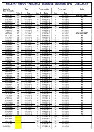
Charles Dalli
Charles Dalli
Charles Dalli

You also want an ePaper? Increase the reach of your titles
YUMPU automatically turns print PDFs into web optimized ePapers that Google loves.
<strong>Charles</strong> <strong>Dalli</strong><br />
Behind the walls, beyond the shores: the urbanization of Malta<br />
[A stampa in Il Mediterraneo delle città, a cura di Enrico Iachello, Paolo Militello, Milano, Franco Angeli,<br />
2011, pp. 75-88; anche in http://malta.academia.edu/<strong>Charles</strong><strong>Dalli</strong>/Papers © dell’autore - Distribuito in<br />
formato digitale da “Reti Medievali”, www.biblioteca.retimedievali.it].
Behind the walls, beyond the shores:<br />
the urbanization of Malta<br />
di <strong>Charles</strong> <strong>Dalli</strong><br />
The story of Malta’s pre-modern urban development is inextricably<br />
linked to the island’s gradual transformation from a Sicilian dependency in<br />
the Crown of Aragon with a mainly rural population of about 20.000<br />
around 1500, into an island principality with approximately half of its total<br />
population of about 100.000 in 1800 living in a heavily fortified and<br />
urbanized harbour area 1. Governed by the Hospitaller Grand Masters<br />
(1530-1798), the Maltese islands evolved into a Catholic theocratic principality<br />
enjoying de facto autonomy from the kingdom of Sicily 2. Malta’s<br />
location at the crossroads of the Mediterranean world defined the course of<br />
its history. Following the British blockade of the French forces left by<br />
Napoleon to hold the islands in 1798, Malta became a British possession.<br />
The fortress colony served strategic British interests in the Mediterranean,<br />
and enjoyed periods of prosperity in times of war. The centripetal<br />
movement which had developed under the Order was further encouraged<br />
by the harbour-centred economy under British rule. The population, which<br />
doubled in the nineteenth century despite substantial migration, was<br />
heavily concentrated in the harbour area, where the early modern<br />
metropolitan port-town formed by Valletta and its suburb Floriana,<br />
together with the Three Cities of Birgu (Vittoriosa), Bormla (Cospicua)<br />
and Isla (Senglea) expanded especially after the opening of Suez in 1869<br />
through suburban growth outside the lines of fortifications built by the<br />
Hospitallers. The Maltese harbour area came under substantial attack in<br />
the Second World War, causing a substantial population outflow. The<br />
modern urbanization of Malta since 1950 has taken place largely outside<br />
1. For population estimates for the medieval period: A. Luttrell (ed), Medieval Malta.<br />
Studies on Malta before the knights, London 1975. For population growth in the Hospitaller<br />
period: V. Mallia-Milanes (ed), Hospitaller Malta. Studies on Early Modern Malta and<br />
the Order of St John of Jerusalem, Malta 1993.<br />
2. V. Mallia-Milanes (ed), Hospitaller Malta…, cit.<br />
75
the walls of the eighteenth century Hospitaller metropolitan port town,<br />
which provided the original nucleus for the process. The independent<br />
island republic of 320 km 2, which today counts a population of approximately<br />
400.000, includes in its official emblem a golden mural crown with<br />
turrets, symbolizing its status as a fortress city state. More than 90% of the<br />
population is urbanized, somewhat supporting the concept of Malta, an EU<br />
member state, as an island city state.<br />
There was nothing in the ancient and medieval background to<br />
Hospitaller Malta to suggest the metropolitan development which would<br />
take place under Hospitaller and British rule. In Antiquity the population<br />
of the archipelago, which comprised the two inhabited islands of Malta<br />
and Gozo, was mainly concentrated in two walled settlements with their<br />
suburbs, supported by a network of anchorages which supplied the<br />
islanders with their needs, and exported their produce 3. The location of<br />
Malta and Gozo sixty miles south of Capo Passero in Sicily was one major<br />
factor conditioning their development for much of their history as a<br />
satellite of Sicily. The concentration of Gozo’s small population (about<br />
5.000 around 1500), organized into four parishes in the castle and suburb<br />
of the island (the madina or castle of Gozo and its Rabat, present day<br />
Victoria), remained a characteristic of that island until the seventeenth<br />
century 4. On Malta, the late medieval population geography was characterized<br />
by a network of villages organized into twelve parishes with the<br />
market town of Mdina 5. The town was the political and social centre of<br />
Malta down to 1530, and was home to the island’s principal families,<br />
including those fiefholders who were not absentees. The royal officials<br />
together with the councillors forming the municipal body or universitas<br />
based there administered the town as well as the island’s village<br />
communities, managed the upkeep of the fortifications and regulated the<br />
manning of the watch posts, ran a small public hospital, appointed the<br />
school master, supervised the markets, issued regulations and even<br />
appointed consuls to represent the Maltese in the chief Sicilian towns 6.<br />
The seat of a bishopric documented in the Byzantine period, later held<br />
from the mid-twelfth century to 1530 by mainly absentee bishops who also<br />
enjoyed estates near Lentini, Mdina was the ecclesiastical centre of the<br />
archipelago. In the 1400s Mdina and Rabat witnessed the establishment of<br />
3. For an overview of Phoenician to Roman Malta see A. Bonanno, Malta Phoenician<br />
Punic and Roman, Malta 2005.<br />
4. Essay by G. Wettinger in C. Cini (ed), Gozo The roots of an island, Malta 1990.<br />
5. For an overview of the medieval period see C. <strong>Dalli</strong>, Malta. The Medieval Millennium,<br />
Malta 2006.<br />
6. G. Wettinger (ed), Acta iuratorum et consilii civitatis et insulae Maltae, Palermo<br />
1993.<br />
76
Augustinian, Carmelite, Dominican, and Francescan friaries, as well as<br />
two Benedictine nunneries 7.<br />
«The Town and Island of Malta»<br />
The hill top had a long history of human settlement, according to recent<br />
archaeological excavations extending back to c.1000 BCE. Phoenicians<br />
colonized the islands from c.800 BCE, and their Carthaginian descendants<br />
held the towns and islands until the start of the Second Punic War 8. The<br />
ancient walled town of Melite where the island’s population resided in the<br />
Roman centuries (c.218 BCE- CE 440; Byzantine reconquest in 535) was<br />
succeeded possibly in the late Byzantine era (c.700-870) by a smaller<br />
walled town, the madina of the Arab period (870-1091) 9. Malita and<br />
Gawdi? were recorded laconically in Arab geographical compilations,<br />
while more detailed accounts of the Muslim conquest were entered in the<br />
later works of al-Qazwīnī and al-Himyarī. The latter author stated in his<br />
opus Kitāb ar-Rawd al-Mi‘tār [The book of the fragrant garden] that the<br />
island was depopulated by the Muslim conquerors in 870, and that the<br />
town of Malta was refounded around the year AH440 [1048-1049]. In<br />
1091 the town was forced to come to terms with the Norman leader Roger<br />
of Hauteville, entering into tributary obligations and surrendering to the<br />
ruler of Sicily a large number of Christian captives, as well as beasts,<br />
weapons and money 10. In an undated process which may stretch back to<br />
the twelfth century, the transformation of the islands into a dependency<br />
under Latin Christian lordship, and the subjection of the Muslim<br />
population, were reflected in the proliferation of more than one hundred<br />
rahl (Maltese rahal) type establishments across the Maltese countryside 11.<br />
By c.1400, the settlement pattern on Malta was predominantly rural, with<br />
c.three-quarters of the population dispersed in villages 12.<br />
The establishment of the Hospitaller Order of St John in Malta in 1530<br />
underlined the limitations of the island’s urban and defensive infrastructure,<br />
which proved to be largely inadequate to meet the logistical and<br />
material requirements in accommodating the religious and military organi-<br />
7. M. Buhagiar Mario & S. Fiorini, Mdina: the Cathedral City of Malta, 2 voll., Malta<br />
1996.<br />
8. The period is discussed in A. Bonanno, Malta Phoenician Punic and Roman…, cit.<br />
9. The medieval transition is studied in C. <strong>Dalli</strong>, Malta…, cit.<br />
10. The text of Geoffrey Malaterra is discussed in ivi.<br />
11. G. Wettinger, Place-names of the Maltese islands, c.1300-1800, Malta 2000, pp.<br />
271-292.<br />
12. See essay by G Wettinger in A. Luttrell (ed), Medieval Malta…, cit.<br />
77
zation. The ancient town of Malta, the civitas or medieval madina with its<br />
suburb (modern day Mdina and Rabat) could never satisfy the social,<br />
military and naval requirements of the Hospitaller administrators and their<br />
maritime squadron. Quite similarly to the castello which defended the terra<br />
of Gozo, with a settlement history extending back to the first millennium<br />
BCE, Mdina was a hilltop walled town commanding a strategic point in<br />
central Malta, located about six miles from the main harbour, which could<br />
respond to the challenges of sixteenth century warfare in a very limited<br />
way. Local militiamen patrolled the countryside and kept permanent watch<br />
posts to give sign of regular sightings of raiding ships and enemy landings.<br />
The defence of Malta hinged on the ability of much of the population to<br />
seek timely shelter behind the crumbling walls of Mdina, and in the<br />
castrum maris which stood at least from c1200. A garrison under the<br />
command of a castellan normally defended this stronghold. The sea castle<br />
offered protection to the small seafaring community residing in the Borgo<br />
(present day Birgu) which developed outside its walls, across one of the<br />
southern lateral promontories indenting the Maltese port. This anchorage<br />
was still called Marsachibir in the fifteenth century Chompasso de tuta la<br />
starea della marina (Vat. Lat. 5300) (Marsa Kabir, modern day Grand<br />
Harbour). In the fourteenth and fifteenth centuries, the islands were located<br />
perilously in frontiera de Barbaria, and Aragonese rulers were hardly<br />
inclined to invest sparse resources in their urban and defensive infrastructure<br />
13.<br />
Civitas and Terra: Archipelagic Diversity<br />
The urban landscape of the Maltese islands up to 1530 was limited to<br />
the terra of Gozo, the civitas of Malta – a walled town defended by a<br />
castrum civitatis until c.1450, together with the suburb of Rabat which<br />
survives to this day – and the castrum maris with its borgo, guarding the<br />
harbour. It was an arrangement which possibly came into being around<br />
1200, in an era of political transition between direct royal government, and<br />
feudal lordship under comital governors holding the archipelago. The three<br />
garrisoned castles, key fortifications of the archipelago were recorded<br />
under the administration of Frederick II’s financial governor in Malta,<br />
Giliberto Abate, around 1240. It is plausible that the defensive network<br />
guaranteeing the Latin Christian control in the islands, which still had a<br />
substantial Muslim community in 1240, had been established or at any rate<br />
consolidated under the Counts of Malta. The latter included admiral<br />
13. C. <strong>Dalli</strong>, Malta…, cit.<br />
78
Margaritus of Brindisi, and his Genoese successors in the Sicilian<br />
admiralty after 1194 – William Grasso and his son in law Henry Pescatore,<br />
an ambitious privateer who for some time lured Genoa into his ambitious<br />
project to take control of the island of Crete. The set up changed very little<br />
in the later Middle Ages. Fifteenth century attempts by the municipal<br />
authorities in town, frequently backed by Crown appointed officials, to<br />
force wealthier villagers to move to permanent residence within the walls<br />
Mdina generally failed. There seemed to be much villager resistance at<br />
these blatant attempts at compulsory urbanization. There must have been<br />
clear social and economic advantages attached to continued residence in<br />
the undefended open settlements of the Maltese countryside, despite the<br />
fact that the island bore its share of enemy attacks, as did Gozo. From a<br />
register of over 100 rahal toponyms across the Maltese countryside, a<br />
substantial number referred to uninhabited estates by 1400. Nevertheless, it<br />
is difficult to translate toponymic evidence into a broader geographic<br />
frame – for one thing, it remains unclear how many of the rahal<br />
placenames denoted anything beyond simple farmsteads, to start off with.<br />
A clear difference between the two islands remains evident. Somewhat<br />
enigmatically, contrary to the Maltese network of villages, on the sister<br />
island of Gozo, human settlement seems to have been agglomerated from<br />
the 1300s to the 1600s at the terra – the castle and its Rabat. The odd<br />
reference to rahl type toponyms on Gozo cannot be confirmed. It must be<br />
added that the island of Pantelleria too retained its villages in this period,<br />
despite its repeated targeting by raiders. There may have been other<br />
causes, besides the quotient of enemy attacks per island, guiding the<br />
emergence, survival or disappearance of open undefended villages,<br />
including social ones. At the risk of speculating on the back of an already<br />
hotly debated document, one might suggest that the large number of<br />
Christian serf families documented on Gozo in 1240 created a different set<br />
of conditions when compared to the much larger Muslim serf populations<br />
on Malta – and also perhaps Pantelleria. Villages in the islands were<br />
certainly targeted in a punitive attack carried out by James II’s admiral<br />
Bernat de Sarria against the insular subjects of Frederick III of Sicily.<br />
Evidence for parish organization outside the castrum maris and its borgo<br />
comes to light at the end of the fourteenth century. The survival of<br />
toponyms long after the transformation of social or cultural realities<br />
underpinning them is a proven trend. Around 1394, the pilgrim notary<br />
Nicola de Martoni reported the prosperity of Gozo and Malta under count<br />
Artale de Alagona. His figures of 400 houselholds on Gozo, and 4000 on<br />
Malta seem a bit inflated, but they do convey the general positive<br />
perception of the Italian vistor.<br />
Militia rosters and watch lists from 1417 and 1419 respectively studied<br />
by Godfrey Wettinger, suggest an adult male population on Malta of about<br />
79
2000 individuals, producing a plausible figure of 10.000. Considering the<br />
fact that the population of c.5000 people on Gozo was concentrated at the<br />
castle and Rabat, the Gozitan town was the largest urban centre in the<br />
Maltese islands up to 1530. By 1530 some of the major villages may have<br />
had a population over 1000, in a total population which perhaps had<br />
reached 20.000. Following open rebellion against the governor of the<br />
island Gonsalvo de Monroy in 1425-1428, the citizens were allowed by<br />
Alfonso the Magnanimous to pawn their islands for 30.000 Aragonese<br />
florins. Mdina was styled in a royal charter as «Notabile». The successful<br />
negotiations by town leaders with the Crown were to be the cornerstone of<br />
a century of municipal rule ending with the establishment of the Order of<br />
St John in Malta in 1530. Centuries later, in the quest for improving<br />
Malta’s constitutional status under British colonial rule, frequent reference<br />
would be made to a purported late medieval chapter of municipal<br />
autonomy under a «Consiglio Popolare». Mdina Notabile, or Città<br />
Vecchia, was to be after 1530 the antithesis of Hospitaller Malta, the<br />
cathedral city where the Order’s presence was relatively limited until 1700.<br />
The catastrophic earthquake of 1693 created the opportunity for the total<br />
rebuilding of the cathedral church, as well as the erection of a magistral<br />
palace in the Baroque style, adding new layers to the historic urban<br />
palimpsest of Mdina and Rabat.<br />
«The Jews of these islands»<br />
Mdina, Birgu and the citadel on Gozo were characterized by lively<br />
Jewish communities, which formed an instrinsic element in the social<br />
fabric of the islands until their expulsion in 1492 14. Jewish communities<br />
were a dominant characteristic of most towns in the kingdom of Sicily.<br />
Municipal plans in 1458 to enclose the Jewish community at Mdina in a<br />
ghetto were approved by the Crown, but did not materialize. The lack of<br />
reliable statistical records has not deterred historians from attempting to<br />
estimate the size of the Jewish population. It has been suggested that at the<br />
moment of expulsion, the Jewish community of Mdina may have<br />
numbered around 500 individuals, making it a substantial community in a<br />
town whose total population could have not exceeded 2.500 by far. In<br />
other words, a quarter of the townspeople in late medieval Malta may have<br />
been Jewish. To these one must add the small community at Birgu, which<br />
must have been much more modest, considering that Birgu’s total<br />
population is not estimated to have exceeded 250 in the late 1400s. A<br />
14. G. Wettinger, The Jews of Malta in the late Middle Ages, Malta 1985.<br />
80
separate Jewish community resided at the Gozo castle. In all, the Jewish<br />
communities may have totalled c.600 individuals. They were subjected<br />
respectively to the jurisdictional control of the chief royal officials in the<br />
islands, namely the Captains of Malta and Gozo and, in the case of the<br />
Jews at Birgu, the castellan. Needless to say, Jews had their own separate<br />
institutions, and conducted their own affairs, paying their taxes separately<br />
and dispatching envoys to the Crown on behalf of their communities.<br />
Considering the relatively large proportion of Jews to the total population<br />
of Mdina, the documented cases of religious tension or strife are<br />
remarkably few. The Jews of the islands included wealthy owners of real<br />
estate, as well as humble craftsmen, learned elders as well as numerous<br />
petty traders who were repeatedly forbidden from peddling their wares<br />
from village to village thus bypassing the control of the market supervisors<br />
at Mdina.<br />
«Bulwark of Christendom»<br />
The urban development to take place in Malta after 1530, including the<br />
building of a new capital city, was intrinsically related to the archipelago’s<br />
defence needs, and constituted a main element in the strategy adopted to<br />
deflect the Ottoman threat. The Hospitaller base earned the epithet of a<br />
regional propugnaculum Europae, immortalized in Megiser’s work 15. The<br />
Order’s bellicose vocation and Malta’s role on the foreground of the<br />
Habsburg-Ottoman conflict in the Mediterranean, especially in the period<br />
1551-1571, found their natural expression in the complex process of<br />
fortification building, which went on until the very last decade of<br />
Hospitaller government in the islands. Nevertheless, the strategies devised<br />
to respond to Malta’s defensive needs were also intertwined with the<br />
archipelago’s social and economic development 16. The waves of fortressand<br />
town-building were also linked to Malta’s changing social and<br />
economic texture, and represented substantial infrastuctural investment<br />
whilst drawing on local and foreign manpower 17. The defensive «stone<br />
curtain» encircling the harbour area was considered to be practically<br />
impregnable by late eighteenth century standards, and reflected the Order’s<br />
15. T. Freller & A. Friggieri, Malta The Bulwark of Europe: Hieronymus Megiser’s<br />
Propugnaculum Europae. The first comprehensive German description of sixteenth century<br />
Malta, Malta 1998.<br />
16. A. Hoppen Alison, The Fortification of Malta by the Order of St John, 1530-1798,<br />
Edinburgh 1979.<br />
17. Q. Hughes, The Building of Malta during the period of the Knights of St John of Jerusalem,<br />
1530-1795, Revised Edition, London 1967.<br />
81
successful strategy of deterrence as well as the essential anxiety of<br />
survival. Averting the pitfalls of historical hindsight, one should hasten to<br />
add that none of this was a foregone conclusion.<br />
The eight knights commissioned by the Order in 1524 to report on the<br />
proposed establishment of the Convent at Malta, were not oblivious to the<br />
strategic potential of the island’s fine natural harbour, noting the defensive<br />
value of the predominant tongue of land which divided the port into two<br />
halves – the promontory called Sceberras where, in the months which<br />
followed the Ottoman siege of Malta of 1565, the foundation stone of the<br />
new fortress capital city of Valletta would be laid. Notwithstanding the<br />
strategic value of the Maltese haven, which could provide the Catholic<br />
organization with a vital base from which to fulfil its mission as a frontier<br />
fighting force, the disadvantages in the Habsburg offer of Malta and Gozo<br />
with Tripoli seemed to outweigh decisively any perceivable benefit. The<br />
commissioners, who represented the Order’s eight different langues,<br />
presented the Master L’Isle Adam and his Convent with an overall<br />
negative report, underlining the archipelago’s severe material limitations<br />
and defensive vulnerability 18.<br />
The Castrum Maris (modern Fort St Angelo) and its medieval Borgo or<br />
suburbium maris (present day Birgu) became the new seat of the<br />
Hospitaller government. The establishment of the Convent at Birgu led to<br />
its rapid transformation as a «New Town». During their forty-year stay at<br />
Birgu, the Order rebuilt substantial parts of the suburb, adopting the parish<br />
church of St Lawrence as their main ecclesiastical centre, and delimiting<br />
exclusive quarters which were to serve the brethren as a collachium. The<br />
knights built a network of auberges along Birgu’s narrow streets, opened<br />
an Infirmary, and embarked on a series of works to defend their «New<br />
Town’ 19. In 1551, the Order lost Tripoli. Following a devastating Muslim<br />
attack led by Dragut on the Maltese islands in late July 1551, which led to<br />
the capture and deportation of thousands of inhabitants from the poorly<br />
defended smaller island of Gozo, the Muslim forces attacked Tripoli and<br />
took it on 14 August after a short siege. In the 1550s the Hospitaller<br />
government redoubled its efforts to fortify the Maltese base, strengthening<br />
the harbour defences – central Fort St Elmo, which would be incorporated<br />
from 1566 as the seaward bulwark of the new fortress capital, as well as<br />
the two fortresses protecting access to two main creeks in the lower part of<br />
the Maltese port, namely Fort St Angelo with Birgu, and Fort St Michael<br />
defending the new town of Senglea which emerged across the Isola di San<br />
18. G. Bosio, Dell’Istoria della sacra religione ed illustrissima militia di S.Giovanni<br />
Gierosolimitano, 3 voll., II ed., Roma e Napoli 1621 (vol. 3, pp. 30-31).<br />
19. On Birgu see the contributions in L. Bugeja, M. Buhagiar & S. Fiorini, Birgu A<br />
Maltese Maritime City, 2 voll., Malta 1993.<br />
82
Michele. It also took formal steps to embark on the project of a new<br />
Convent City. A decade after Cosimo I built Cosmopolis, present day<br />
Portoferraio, and fortied it on the island of Elba, Jean de Valette and his<br />
Council took the decision to give the Order and Malta a new<br />
Renaissance city.<br />
«Give me time and I will give you life» 20<br />
The Ottoman siege of Hospitaller Malta in May-September 1565<br />
underlined the shortcomings of the island’s defences, and dispelled any<br />
remaining doubts about the vital necessity of a new fortified city. Shelved<br />
because of the siege, the project would now consume the island’s depleted<br />
resources and energies for the next few years. Moreover the building of<br />
Valletta was the best sign the Order could give that it was determined to<br />
stay in Malta. With the help of Pius V, as well as France and Spain, the<br />
Order embraced the designs of Francesco Laparelli of Cortona for a new<br />
fortified Convent City laid out in the form of an orthogonal grid with the<br />
magistral palace and conventual church at its centre. «Give me time and I<br />
will give you life», reads an often-quoted verse in the Codex Laparelli.<br />
The foundation stone of the Humilissima Civitas Valettae was laid on 28<br />
March 1566, and within five years the knights were able to formally<br />
transfer the Convent from Birgu to the new city. Laparelli as well as the<br />
Maltese architect Gerolomo Cassar master-minded Valletta’s transformation<br />
into a habitable city with the auberges and other palaces which<br />
could accommodate the Order’s government and house the knights of each<br />
langue 21. Cassar drew the plans for the Order’s Conventual Church of St<br />
John, whose construction started in 1572, while the rectilinear streets of<br />
the new town were gradually populated thanks to a steady influx of people<br />
from Malta’s villages, as well as foreign settlers 22. The Holy Infirmary<br />
where the knights would continue to fulfil their vocation as Hospitallers,<br />
was also founded in 1574 23. Valletta stimulated a major demographic shift<br />
20. Q. Hughes, Give me time and I will give you life. Francesco Laparelli and the building<br />
of Valletta, Malta, 1565-1569, in «The Town Planning Review», vol. 49, n. 1, 1978,<br />
pp. 61-74.<br />
21. S. Paulin, Die Bauten des Malteser Architekten Gerolamo Cassar und deren architekturgeschichtliche<br />
Voraussetzungen, Unpublished dissertation, Institut für Kunstgeschichte<br />
der Westfälischen Wilhelms-Universität 1999; M. Ellul, In search of Girolamo Cassar:<br />
an unpublished manuscript at the State Archives of Lucca, in «Melita Historica», vol. 14 n.<br />
1, 2004, pp. 29-51.<br />
22. V. Denaro, The Houses of Valletta, Malta 1967.<br />
23. Q. Hughes, The Building of Malta during the period of the Knights of St John of Jerusalem…,<br />
cit.<br />
83
as people flocked to settle behind the ramparts of the new, state of the art<br />
capital. Two Roman Catholic parishes, as well as a Greek Catholic parish,<br />
were established, while the religious congregations took the necessary<br />
steps to open new houses there. The cathedral city of Malta remained<br />
Mdina, but by 1622 the bishop had also taken the necessary steps to<br />
construct an episcopal palace in the city of the knights, leading to a open<br />
political conflict with the Hospitallers and compelling Rome to intervene.<br />
With the migration of the Convent to the new city, the institutions of<br />
state soon started to function there 24. The Magistral Palace (1572) was<br />
built at the heart of Valletta, after planners reportedly rejected an earlier<br />
idea of a magistral stronghold which could be defended autonomously<br />
from the main town during a siege. The definite shift to Valletta as the<br />
archipelago’s chief governmental, economic and cultural centre became<br />
virtually inevitable given the substantial resources invested in the project.<br />
Plans for a walled collachio in the new city, having the effect of detaching<br />
the Hospitaller brethren from the lay population, as was developed at<br />
Birgu in 1532-39, were dropped 25. Valletta may have been famously<br />
described as «a city built by gentlemen for gentlemen», but it was also<br />
cosmopolitan city marked by its diversities. The Order and its people were<br />
contentrated there, but Valletta was not allowed to become a Hospitaller<br />
oasis. The success of the market town was soon reflected in numbers. In<br />
the late 1570s it was already reported, perhaps with some exaggeration,<br />
that the population of Valletta was close to 8.000 residents, half of whom<br />
were civilians, and the other half were professed members and the Order’s<br />
retinue. The town population distributed in 701 households was realistically<br />
numbered at 3.397 in 1590, again representing almost half the total<br />
population 26.<br />
Under the Hospitaller government Valletta would become the centrepiece<br />
of a metropolitan area defended by about twenty-seven kilometres of<br />
fortifications. The urbanization of Malta’s growing population was<br />
remarkable. In the last decade of the sixteenth century, about one-third of a<br />
population close to 30.000 lived in Valletta and the Three Cities. At the<br />
Order’s expulsion from Malta in 1798, the percentage had grown to<br />
encompass an even larger share of the total population of about 100.000<br />
24. Q. Hughes Quentin, Documents on the building of Valletta, in «Melita Historica»,<br />
vol. 7 n. 1, 1976, pp. 1-16.<br />
25. V. Mallia-Milanes, Valletta 1566-1798: An Epitome of Europe, in «Bank of Valletta<br />
Annual Report and Financial Statements», Malta 1988.<br />
26. C. Cassar, Society, Culture and Identity in Early Modern Malta, Malta 2000; G.<br />
Aquilina George & S. Fiorini (eds), Documentary Sources of Maltese History. Part IV Documents<br />
at the Vatican. No1 Archivio Segreto Vaticano Congregazione Vescovi e Regolari.<br />
Malta: Visita Apostolica no.51 Mgr Petrus Dusina 1575, Malta 2001.<br />
84
people. Around 1807 one estimate of the population of Valletta and its<br />
suburb of Floriana was 24.546, while Cospicua, Vittoriosa and Senglea<br />
(collectively known as the Cottonera from the defenceworks built under<br />
Grand Master Nicolas Cotoner) had an estimated combined population of<br />
13.676 (6.224, 3.300 and 4.152 respectively). The harbour population of<br />
38.222 therefore represented almost half total population for the island of<br />
Malta of 80.225 27.<br />
[Arcipelago maltese], in G.F. Abela, Malta illustrata. Della descrizione di Malta, isola<br />
nel Mare Siciliano, con le sue antichità, ed altre notizie, Malta 1647<br />
«An Epitome of All Europe»<br />
Patrick Brydone’s description of Hospitaller Malta as «an epitome of all<br />
Europe» and «one of the best academies for politeness in this part of the<br />
globe» echoed the cosmopolitan environment of the harbour metropolis<br />
built by the Order as experienced by numerous travellers 28. In his Giro del<br />
27. Figures compiled in R. Montgomery Martin, History of the Colonies of the British<br />
Empire, London 1843.<br />
28. P. Brydone, A Tour through Sicily and Malta, Dublin 1777.<br />
85
Mondo, Gio. Francesco Gemelli Careri made up for his misadventure with<br />
a Maltese tartana when entering the port of Malta and witnessing the<br />
transformation that human art had made to the barren rocky island 29.<br />
Riedesel expressed his particular astonishment at seeing the harbour and<br />
its fortifactions 30. The importance of the Hospitaller fortified harbour<br />
metropolis as Malta’s political, economic and social centre continued to<br />
grow under British rule. The walled conurbation formed by Valletta,<br />
Floriana, and the Cottonera was an extended memory theatre of palatial<br />
buildings, warehouses, marketplaces, public works and defence structures<br />
which functioned as a Hospitaller capital until 1798, and then was to<br />
provide the basic physical infrastructure for the British colonial presence<br />
until the twentieth century.<br />
The promontory which hosted St Elmo and Valletta was further<br />
developed in the early seventeenth century with the foundation of Floriana<br />
named after its designer, the engineer Pietro Paolo Floriani from Macerata.<br />
New fortifications for Cospicua, called the Santa Margherita lines, were<br />
designed by Vincenzo Maculano da Firenzuola, who was also responsible<br />
for Forte Urbano in Rome. Under the magistracy of Nicolas Cotoner in<br />
1670 a massive project was initiated to encircle Vittoriosa, Cospicua and<br />
Senglea with a new line of fortifications drawn up by Antonio Maurizio<br />
Valperga, later called the Cottonera lines, extending for mor ethan eight<br />
kilometres. Fortresses to defend the key points of the harbour area,<br />
including Fort Ricasoli designed by Valperga in 1670, and Fort Manoel<br />
founded by Grand Master Manoel de Vilhena on the small island in<br />
Marsamxett harbour, designed in 1723 by <strong>Charles</strong> François de Mondion 31.<br />
A major project was commenced on Gozo in 1749 with the construction of<br />
Fort Chambray overlooking the main port of that island. Shortly before the<br />
Order’s expulsion from Malta at the hands of Napoleon, the final fortification<br />
project was launched – Fort Tigne, designed by Stefano de Tousard<br />
in 1792 32.<br />
The Hospitaller «epitome of Europe» contrasted sharply with the<br />
dwellings resembling African huts reported at Birgu by Quintinus in 1533,<br />
and with the troglodytic practices which had survived among Maltese rural<br />
29. G.F. Gemelli Careri, Giro del Mondo, 6 voll., Napoli 1699-1700.<br />
30. T. Freller, A classical traveller in eighteenth-century Malta: Johann Hermann von<br />
Riedesel, Malta 1997.<br />
31. D. De Lucca, Mondion: The achievement of a French military engineer working in<br />
Malta in the early eighteenth century, Malta 2003.<br />
32. Q. Hughes, The Building of Malta during the period of the Knights of St John of Jerusalem…,<br />
cit.; Q. Hughes, Fortress: Architecture and Military History in Malta, Malta<br />
2001; S. Spiteri, Fortresses of the Knights, Malta 2001; S. Spiteri, The art of fortress building<br />
in Hospitaller Malta, Malta 2008.<br />
86
communities 33. There was also the polarity Valletta and Mdina, a<br />
dichotomy between the old capital city and the new, but also between the<br />
maritime convent city of the Hospitallers, and the ancient rural stronghold<br />
and cathedral city which represented Malta’s past. Nevertheless, the extent<br />
of enclavization of the Hospitaller harbour metropolis is difficult to<br />
measure, as Malta’s smallness placed a whole network of villages within<br />
walking distance of the bustling harbour communities and the commercial<br />
hubs of the port 34. Under the paternalistic and relatively benevolent<br />
government of the Order, there was a substantial degree of cultural assimilation<br />
35. The physical process of urbanization reflected in the harbour area<br />
was culturally embedded in official titles. Together with Valletta, the<br />
walled towns of Birgu (called Città Vittoriosa in commemoration of the<br />
victory against the Ottomans in 1565), Bormla (named Città Cospicua with<br />
reference to its strong walls in 1722) and Isla (Città Senglea, in honour of<br />
its found the Grand Master Claude La Sengle, formally Città Invicta),<br />
represented an «epitome» which other communities down the settlement<br />
hierarchy wanted to emulate. Several Grand Masters in the age of the<br />
Enlightenment 36 were willing to comply, no doubt perceiving the political<br />
benefits of this harmless type of populism. Floriana was formally designed<br />
as Borgo Vilhena. Under the magistracy of Antoine de Paule, a new nonfortified<br />
village was desgined called Casal Paola reproducing the street<br />
planimetry of Valletta, with a parish church dedicated to one of the Order’s<br />
female patrons, St Ubaldesca. Moreover, three eighteenth century Grand<br />
Masters (Pinto de Fonseca, Rohan Polduc, and Hompesch) extended their<br />
patronage to some of the principal villages, raising them to the status of<br />
towns: Qormi (Città Pinto, 1743), Zebbug (Città Rohan, 1777), Siggiewi<br />
(Città Ferdinand, 1797), Zabbar (Città Hompesch, 1797) and Zejtun (Città<br />
Beland, 1797). The urban promotion of these agrotowns may reflect<br />
deeper underlying symptoms of cultural assimilation. The process was<br />
resumed under British rule, when Rabat on Gozo was renamed Victoria in<br />
celebration of the Queen’s jubilee (1887), while a new port town at Marsa<br />
was founded named after Albert.<br />
The Order’s relative absence from ancient Melite was broken in 1619-<br />
1621 under Grand Master Alof de Wignacourt with the establishment at<br />
Rabat outside the cathedral city of Mdina, at the ancient shrine of St Paul’s<br />
Grotto, of a Hospitaller collegiate church and community of chaplains of<br />
33. H.J. Quintinus, Insulae Melitae descriptio, Lyons 1536.<br />
34. For a discussion of the regional relevance of Malta’s port see G. Simoncini Giorgio,<br />
a cura di, Sopra i porti di mare. Vol 3: Sicilia e Malta, Firenze 1997.<br />
35. V. Mallia-Milanes (ed), Hospitaller Malta…, cit.<br />
36. For a discussion of the effects of the Enlightenment in Hospitaller Malta see F.<br />
Ciappara, Enlightenment and reform in Malta 1740-1798, Malta 2006.<br />
87
obedience 37. The Order also participated in Mdina’s baroque transformation<br />
after 1693 38. As in the Val di Noto, the catastrophe at Mdina led to<br />
substantial rebuilding. This included the erection of a new episcopal<br />
complex which included the cathedral church designed by Lorenzo Gafà,<br />
as well as an episcopal palace and Malta’s first seminary. Grand Master<br />
Vilhena commissioned the building of a magistral palace, designed in 1725<br />
by Mondion, physically anchoring the Hospitaller presence next to the<br />
main entrance of the ancient town 39.<br />
Already in 1647 Gian Francesco Abela attempted the symbolic reconciliation<br />
between the two sides of the urban dichotomy, the old city of Malta<br />
and the new city of the Order 40:<br />
L’Insegna, e Arme della nostra Città Notabile, è un corpo di scudo dal sù all’in<br />
giù bipartito in color bianco, e vermiglio; presagio indubitato, e infallibile della<br />
futura Insegna, e Vessillo, che si doveva alberare, e campeggiare perpetuamente<br />
sovra le sue mura, e bastioni, poiche permise il Signore saggio e prudentissimo<br />
Governatore dell’Universo, che doppo la felicissima venuta dell’Apostolo S. Paolo<br />
in Malta, il quale vi piantò l’albero della fede Christiana, indi havesse per gloria<br />
de’nostri paesani à trasferirvisi l’Eminentissima Republica della Sagra Religione<br />
Gerosolimitana nostra Padrona, per piantarvi il gloriosissimo segno della Santa<br />
Croce bianca in campo vermiglio, acciò dovesse esser quest’Isola il Propugnacolo,<br />
e Baluardo di tutta la Christianità, la Corona del mare, la Reggia di Nettunno,<br />
l’Academia dell’armi, l’Hospitio de’naviganti, Terrore all’Africa, e Asia, Asilo, e<br />
sicurezza dell’Europa tutta.<br />
Behind the walls, beyond the shores: Hospitaller Malta’s urbanization<br />
placed a considerable part of the population behind the walls of a heavily<br />
fortified metropolis, but it was an urbanization which, whilst consuming<br />
the island’s preciously limited resources and energies, was mainly rooted<br />
in a regional role much larger than the island which was to play it, the role<br />
of a frontier bulwark of Catholic Christianity. It was a role which<br />
stimulated its growth and nourished its expansion into a fortified<br />
Hospitaller city-state.<br />
37. See essay by J. Azzopardi in J. Azzopardi, a cura di, Il culto di San Paolo nelle<br />
chiese cristiane e nella tradizione maltese, Malta 2006.<br />
38. See for instance D. De Lucca, Carapecchia: Master of baroque architecture in early<br />
eighteenth century Malta, Malta 1999, on the work of Romano Carapecchia.<br />
39. D. De Lucca, Mdina: A history of its urban space and architecture, Malta 1995; C.<br />
Thake, Mdina: Citadel of Memory, Malta 1995.<br />
40. G.F. Abela, Della Descrittione di Malta isola nel mare siciliano, Malta 1647, p. 56.<br />
88