

the-cathar-trail.pdf - Communauté de Communes du Chalabrais
the-cathar-trail.pdf - Communauté de Communes du Chalabrais
the-cathar-trail.pdf - Communauté de Communes du Chalabrais

You also want an ePaper? Increase the reach of your titles
YUMPU automatically turns print PDFs into web optimized ePapers that Google loves.
catalogue-anglais 9/10/08 18:04 Page 14<br />
12<br />
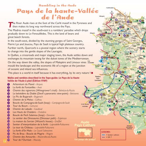
Rambling in <strong>the</strong> Au<strong>de</strong><br />
Pays <strong>de</strong> la haute-Vallée<br />
<strong>de</strong> l’Au<strong>de</strong><br />
The River Au<strong>de</strong> rises at <strong>the</strong> foot of <strong>the</strong> Carlit massif in <strong>the</strong> Pyrenees and<br />
<strong>the</strong>n makes its long way northward across <strong>the</strong> Pays.<br />
The Madres massif in <strong>the</strong> south-east is a ramblers' paradise which drops<br />
gra<strong>du</strong>ally down to Le Fenouillè<strong>de</strong>s. This is <strong>the</strong> land of bears and<br />
great beech forests.<br />
In <strong>the</strong> south-west, divi<strong>de</strong>d by <strong>the</strong> stunning gorges of Saint Georges,<br />
Pierre Lys and Joucou, Pays <strong>de</strong> Sault is typical high plateaux country.<br />
Fur<strong>the</strong>r north, Quercorb is a pivotal region where <strong>the</strong> scenery starts<br />
to change into <strong>the</strong> gentle slopes of <strong>the</strong> Lauragais.<br />
In Quillan, a crossroads and major staging town, <strong>the</strong> Au<strong>de</strong> settles down and<br />
exchanges its mountain twang for <strong>the</strong> <strong>du</strong>lcet tones of <strong>the</strong> Mediterranean.<br />
On <strong>the</strong> way down <strong>the</strong> valley, <strong>the</strong> slopes of Malepère and Limoux vines<br />
mould <strong>the</strong> landscape and <strong>the</strong> economic life of a region at <strong>the</strong> junction<br />
of oceanic and inland sea influences.<br />
This place is a world in itself because it has everything, by its very nature ! ■<br />
Walks and rambles <strong>de</strong>scribed in <strong>the</strong> Topo-gui<strong>de</strong>: Le Pays <strong>de</strong> la Haute<br />
Vallée <strong>de</strong> l’Au<strong>de</strong> à pied (Édition FFRP)<br />
1 Arboretum <strong>du</strong> Planel - Arques<br />
2 La forêt <strong>de</strong> Fontanilles - Axat<br />
3 Chemin <strong>de</strong>s vignerons (Winegrower’s <strong>trail</strong>) - Belvèze-<strong>du</strong>-Razès<br />
4 Le belvédère <strong>du</strong> Diable (Devil’s panoramic view-point) - Belvianes<br />
5 Le Pic <strong>de</strong> Bugarach - Bugarach<br />
6 Chemin <strong>de</strong> la Melso - Cailhau<br />
7 Boucle <strong>de</strong> Campagna-<strong>de</strong>-Sault (loop) - Campagna-<strong>de</strong>-Sault<br />
8 Tour <strong>du</strong> Boum - Camurac<br />
9 Chemin <strong>de</strong> Laba<strong>de</strong> - Cau<strong>de</strong>val<br />
10 Les Hauts <strong>de</strong> Chalabre - Chalabre<br />
11 Boucle <strong>de</strong> Pech Salamou (loop) - Donazac<br />
12 Le sentier <strong>de</strong>s Dinosaures (Dinosaur path) - Espéraza<br />
13 La maison <strong>du</strong> Sorcier (Wizard's house) - Greffeil<br />
14 Sentier d’interprétation <strong>de</strong> la forêt - Lapra<strong>de</strong>lle-Puilaurens<br />
15 Le tour <strong>du</strong> Château - Lapra<strong>de</strong>lle-Puilaurens<br />
16 La forêt d’En Malo - Le Caunil Salvezines<br />
17 Pic <strong>de</strong> Brau - Boucle <strong>de</strong> Magrie - Magrie<br />
18 Chemin <strong>de</strong>s Amouriès - Mazerolles-<strong>du</strong>-Razès<br />
19 Tour <strong>de</strong> l’Ourtiset - Mazuby<br />
Au<strong>de</strong><br />
Pays Cathare<br />
Un pays <strong>de</strong> pays!<br />
LEGEND:<br />
• Sentier <strong>cathar</strong>e<br />
• GR 7