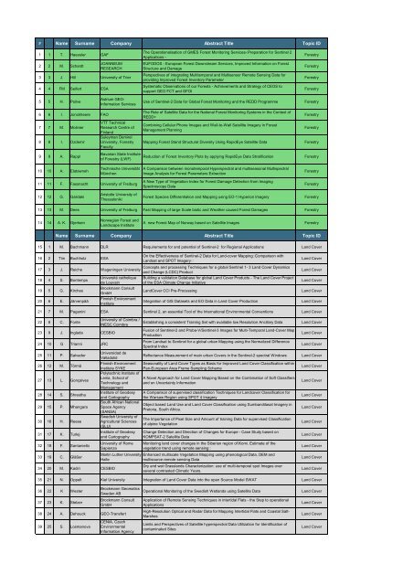
Name Surname Company Abstract Title Topic ID Name Surname ...
Name Surname Company Abstract Title Topic ID Name Surname ...
Name Surname Company Abstract Title Topic ID Name Surname ...

You also want an ePaper? Increase the reach of your titles
YUMPU automatically turns print PDFs into web optimized ePapers that Google loves.
# <strong>Name</strong> <strong>Surname</strong> <strong>Company</strong> <strong>Abstract</strong> <strong>Title</strong> <strong>Topic</strong> <strong>ID</strong><br />
1 1 T. Haeusler GAF<br />
2 2 M. Schardt<br />
JOANNEUM<br />
RESEARCH<br />
3 3 J. Hill University of Trier<br />
4 4 FM Seifert ESA<br />
5 5 H. Poilve<br />
6 6 I. Jonckheere FAO<br />
7 7 M. Molinier<br />
8 8 I. Ozdemir<br />
9 9 A. Rappl<br />
10 10 A. Elatawneh<br />
Astrium GEO-<br />
Information Services<br />
VTT Technical<br />
Research Centre of<br />
Finland<br />
Suleyman Demirel<br />
University, Forestry<br />
Faculty<br />
Bavarian State Institute<br />
of Forestry (LWF)<br />
Technische Universität<br />
München<br />
11 11 F. Fassnacht University of Freiburg<br />
12 12 G. Galidaki<br />
Aristotle University of<br />
Thessaloniki<br />
The Operationalisation of GMES Forest Monitoring Services- Preparation for Sentinel 2<br />
Applications -<br />
EUFODOS - European Forest Downstream Services, Improved Information on Forest<br />
Structure and Damage<br />
Perspectives of integrating Multitemporal and Multisensor Remote Sensing Data for<br />
providing Improved Forest Inventory Parameter<br />
Systematic Observations of our Forests - Achievements and Strategy of CEOS to<br />
support GEO FCT and GFOI<br />
Forestry<br />
Forestry<br />
Forestry<br />
Forestry<br />
Use of Sentinel-2 Data for Global Forest Monitoring and the REDD Programme Forestry<br />
The Role of Satellite Data for the National Forest Monitoring Systems in the Context of<br />
REDD+<br />
Combining Cellular Phone Images and Wall-to-Wall Satellite Imagery in Forest<br />
Management Planning<br />
Forestry<br />
Forestry<br />
Mapping Forest Stand Structural Diversity Using RapidEye Satellite Data Forestry<br />
Reduction of Forest Inventory Plots by applying RapidEye Data Stratification Forestry<br />
A Comparison between monotemporal Hyperspectral and multiseasonal Multispectral<br />
Image Analysis for Forest Parameters Extraction<br />
A New Type of Vegetation Index for Forest Damage Detection from Imaging<br />
Spectroscopy Data<br />
Forestry<br />
Forestry<br />
Forest Species Differentiation and Mapping using EO-1 Hyperion Imagery Forestry<br />
13 13 M. Dees University of Freiburg Fast Mapping of large Scale biotic and Weather caused Forest Damages Forestry<br />
14 14 A. K. Gjertsen<br />
Norwegian Forest and<br />
Landscape Institute<br />
A new Forest Map of Norway based on Satellite Images Forestry<br />
<strong>Name</strong> <strong>Surname</strong> <strong>Company</strong> <strong>Abstract</strong> <strong>Title</strong> <strong>Topic</strong> <strong>ID</strong><br />
15 1 M. Bachmann DLR Requirements for and potential of Sentinel-2 for Regional Applications Land Cover<br />
16 2 Tim Buchholz ESA<br />
17 3 J. Reiche Wageningen University<br />
18 4 S. Bontemps<br />
19 5 G. Kirches<br />
20 6 E. Järvenpää<br />
Université catholique<br />
de Louvain<br />
Brockmann Consult<br />
GmbH<br />
Finnish Environment<br />
Institute<br />
On the Effectiveness of Sentinel-2 Data for Land-cover Mapping: Comparison with<br />
Landsat and SPOT Imagery<br />
Concepts and processing Techniques for a global Sentinel 1- 3 Land Cover Dynamics<br />
and Change (LCDC) Product<br />
Building a validation Database for global Land Cover Products - The Land Cover Project<br />
of the ESA Climate Change Initiative<br />
Land Cover<br />
Land Cover<br />
Land Cover<br />
LandCover CCI Pre-Processing Land Cover<br />
Integration of GIS Datasets and EO Data in Land Cover Production Land Cover<br />
21 7 M. Paganini ESA Sentinel 2, an essential Tool of the International Environmental Conventions Land Cover<br />
22 8 C. Fonte<br />
23 9 J. Inglada CESBIO<br />
24 10 G Trianni JRC<br />
25 11 P. Salvador<br />
26 12 M. Törmä<br />
27 13 L. Gonçalves<br />
28 14 S. Shrestha<br />
29 15 P. Mhangara<br />
30 16 H. Reese<br />
31 17 K. Turlej<br />
32 18 F. Santaniello<br />
33 19 C. Gläßer<br />
34 20 M. Kadiri CESBIO<br />
University of Coimbra /<br />
INESC Coimbra<br />
Universidad de<br />
Valladolid<br />
Finnish Environment<br />
Institute SYKE<br />
Polytechnic Institute of<br />
Leiria, School of<br />
Technology and<br />
Management<br />
Institute of Geodesy<br />
and Cartography<br />
South African National<br />
Space Agency<br />
(SANSA)<br />
Swedish University of<br />
Agricultural Sciences<br />
(SLU)<br />
Institute of Geodesy<br />
and Cartography<br />
University of Rome<br />
Sapienza<br />
Martin Luther University<br />
Halle<br />
Establishing a consistent Training Set with available low Resolution Ancillary Data Land Cover<br />
Fusion of Sentinel-2 and Proba-V/Sentinel-3 Images for Multi-Temporal Land-Cover Map<br />
Production<br />
From Landsat to Sentinel for a global urban Mapping using the Normalized Difference<br />
Spectral Index<br />
Land Cover<br />
Land Cover<br />
Reflectance Measurement of main urban Covers in the Sentinel-2 spectral Windows Land Cover<br />
Seasonality of Land Cover Types as Basis for Improved Land Cover Classification within<br />
Pan-European Area Frame Sampling Scheme<br />
A Novel Approach for Land Cover Mapping Based on the Combination of Soft Classifiers<br />
and on Uncertainty Information<br />
A Comparison of supervised classification Techniques for Landcover Classification for<br />
the Warsaw Region using SPOT 4 Imagery<br />
Object based Land Use and Land Cover Classification using Sumbandilasat Imagery in<br />
Pretoria, South Africa.<br />
The Importance of Pixel Size and Amount of training Data for supervised Classification<br />
of alpine Vegetation<br />
Change Detection and Direction of Changes for Europe - Case Study based on<br />
KOMPSAT-2 Satellite Data<br />
Monitoring land cover changes in the Siberian region of Komi. Estimate of the<br />
vegetation trend using remote sensing<br />
Enhanced mulitscale Vegetation Mapping using phenological Data, DEM and<br />
multisource remote sensing Data<br />
Dry and wet Grasslands Characterization: use of multi-temporal spot Images over<br />
several contrasted Climatic Years.<br />
Land Cover<br />
Land Cover<br />
Land Cover<br />
Land Cover<br />
Land Cover<br />
Land Cover<br />
Land Cover<br />
Land Cover<br />
Land Cover<br />
35 21 N. Oppelt Kiel University Integration of Land Cover Data into the open Source Model SWAT Land Cover<br />
36 22 K Wester<br />
37 23 K. Stelzer<br />
Brockmann Geomatics<br />
Sweden AB<br />
Brockmann Consult<br />
GmbH<br />
38 24 A. Dehouck GEO-Transfert<br />
39 25 S. Losmanova<br />
CENIA, Czech<br />
Environmental<br />
Information Agency<br />
Operational Monitoring of the Swedish Wetlands using Satellite Data Land Cover<br />
Application of Remote Sensing Techniques in intertidal Flats - the Step to operational<br />
Applications<br />
High-Resolution Optical and Radar Data for Mapping Intertidal Flats and Coastal Salt-<br />
Marshes<br />
Limits and Perspectives of Satellite hyperspectral Data Utilization for Identification of<br />
contaminated Sites<br />
Land Cover<br />
Land Cover<br />
Land Cover
<strong>Name</strong> <strong>Surname</strong> <strong>Company</strong> <strong>Abstract</strong> <strong>Title</strong> <strong>Topic</strong> <strong>ID</strong><br />
40 1 W. Park Yonsei University<br />
41 2 C. Rogass<br />
42 3 C. Brockmann<br />
43 4 M. Huc CESBIO<br />
44 5 M. Eder DLR<br />
45 6 A Cristo<br />
Helmholtz Centre<br />
Potsdam GFZ German<br />
Research Centre for<br />
Geosciences<br />
Brockmann Consult<br />
GmbH<br />
Universidad de<br />
Extremadura<br />
Radiometric Cross-Calibration of polar orbital Sensors using Geostationary Ocean Color<br />
Imager (GOCI)<br />
Tools and Methods<br />
Striping Reduction for pushbroom Sensors - Applications to the SENTINEL-2 Mission Tools and Methods<br />
Cloud Screening and Pixel Characterisation at Level 1: IdePix Approach and Validation<br />
using PixBox<br />
Multi temporal Methods for Cloud and Shadow Detections for high resolution optical<br />
Images<br />
On-board Cloud Detection and as a Result on-board Rescheduling of the planned Tasks<br />
for optimization of the Satellite Efficiency<br />
Simulation of Sentinel-2 Data Acquisition and Fusion by using the Diffused Matrix<br />
Format.<br />
Tools and Methods<br />
Tools and Methods<br />
Tools and Methods<br />
Tools and Methods<br />
46 7 F. Thonfeld University of Bonn Simulation of Sentinel-2 images from hyperspectral airborne Data Tools and Methods<br />
47 8 A. Damm RSL<br />
48 9 P. D'Odorico RSL<br />
49 10 J Dash<br />
University of<br />
Southampton<br />
50 11 J Jackson ARGANS<br />
51 12 A. Alessandrini INRA<br />
52 13 M. Weiss INRA<br />
53 14 C. Brockmann<br />
54 15 S. Mantovani MEEO<br />
Brockmann Consult<br />
GmbH<br />
The APEX Vegetation Toolbox to assess Sentinel-2 biochemical and -physical Data<br />
Products<br />
The Dilemma of spectral Performance and Continuity:Comparability of Sentinel-2 SRFs<br />
with other Sensors for Vegetation Monitoring<br />
Evaluating the Performance of the S-2 MSI Sensor for the Estimation of biophysical<br />
Variables in Vegetation<br />
Preparation for Sentinel-2 through Landsat: Data Quality Control within the ESA <strong>ID</strong>EAS<br />
Framework<br />
DEMENAGE: A Meta-Analysis of VALERI Database for the Evaluation of retrieval<br />
Algorithms over a large Range of vegetation Types<br />
The On Line Validation Exercise (OLIVE) Tool: a CEOS/LPV Initiative for Validation of<br />
Land Products<br />
Calvalus - Supporting agile Algorithm Development and large scale Data Processing for<br />
Sentinel 2 and other EO Missions<br />
The Multi-sensor Evolution Analysis (MEA) System for Multi-temporal / Multi-field Data<br />
Exploitation<br />
Tools and Methods<br />
Tools and Methods<br />
Tools and Methods<br />
Tools and Methods<br />
Tools and Methods<br />
Tools and Methods<br />
Tools and Methods<br />
Tools and Methods<br />
55 16 R. Ruiloba C-S Using exogenous Data for image Analysis in the Orfeo ToolBox Framework Tools and Methods<br />
56 17 R. Ruiloba C-S<br />
The Orfeo Toolbox, an open source software for the development of the Venus ground<br />
segment L2 and L3 processors.<br />
Tools and Methods<br />
57 18 M. Grizonnet CNES Potential of Orfeo ToolBox for the Sentinel 2 Preparatory Program Tools and Methods<br />
58 19 S Cherchali CNES The National Land Thematic Centre and its Links with S2 Data Tools and Methods<br />
59 20 C. Tinel CNES<br />
60 21 G. Dedieu CESBIO<br />
61 22 O. Hagolle CESBIO<br />
The Kalideos Databases: a Framework for the scientific Analysis and Exploitation of<br />
Sentinel-2 Images<br />
The Potential of long term territorial Experiments and Living lab Approach to develop<br />
Research and Applications<br />
Production And Distribution Of LANDSAT Time Series To Prepare Sentinel-2<br />
Applications<br />
Tools and Methods<br />
Tools and Methods<br />
Tools and Methods<br />
62 24 C. Woodcock Boston University The Importance of Data Policy: Lessons from Landsat and Implications for Sentinel-2 Tools and Methods<br />
63 25 Z. Mitraka ESA<br />
Land Surface Emissivity Estimation from Synergistic Use of Sentinels 2 and 3 based on<br />
Spatial-Spectral Unmixing Techniques<br />
Tools and Methods