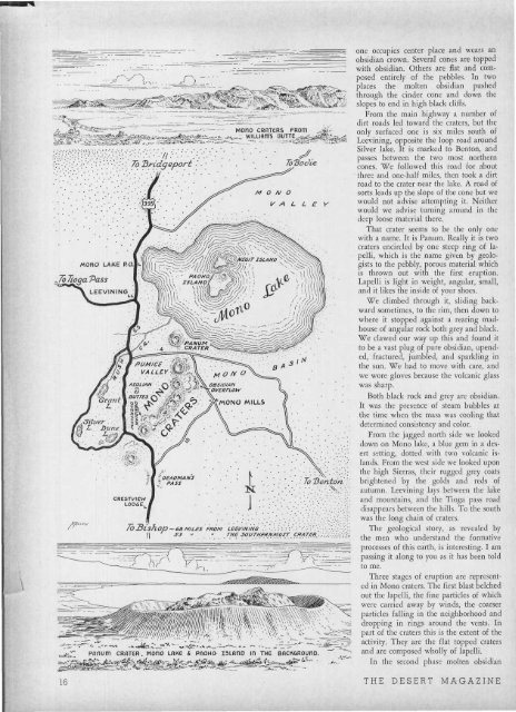
MOnO CROTER5 FROtTl •.•- :: ; v.' To Bridgeport • ' ToUodie 7qJ(oqa Pass MHit-M £ / PUMICE ig
High Sierras, as seen from <strong>the</strong> "hot rocks'' on Paoha island in Mono lake. Frasher photograph. was forced through <strong>the</strong> vent. In some craters it was forced up to a higher elevation than <strong>the</strong> ring <strong>of</strong> lapelli around it. The inner force, however, was not great enough to expel it far<strong>the</strong>r, and <strong>the</strong>re activity ceased. Panum belongs to this group. The third phase is represented by <strong>the</strong> two overflows which I mentioned before. Here <strong>the</strong> eruptive force was great enough to force <strong>the</strong> hot obsidian over <strong>the</strong> top, through <strong>the</strong> encircling cone, and down <strong>the</strong> slopes. But this hot mass was not like most <strong>of</strong> <strong>the</strong> lava overflow with which we are familiar. Most <strong>of</strong>ten <strong>the</strong> lava is extremely hot, and liquid, and flows rapidly and far, ending in low humps. But here it was not extremely hot, only semi-liquid, and it pushed along in a thick sticky mass, cooling so rapidly that it fractured even as it moved. It stopped abruptly in cliffs from 200 to 300 feet high. That is <strong>the</strong> story. From where we stood on Panum we noticed that one portion <strong>of</strong> <strong>the</strong> crater range contained an outcropping <strong>of</strong> black rock. That rock, we have since learned, is <strong>the</strong> oldest exposed rock in <strong>the</strong> group. It is <strong>the</strong> remnant <strong>of</strong> an ancient volcano; it is hornblende andesite, and differs from all <strong>the</strong> o<strong>the</strong>r outcropping in <strong>the</strong> range. Much far<strong>the</strong>r south, and set westward from <strong>the</strong> craters, we noticed two small hills. Isaac Russell named <strong>the</strong>m <strong>the</strong> Aeolian buttes. They are composed <strong>of</strong> pink rhyolite. From Panum we took specimens <strong>of</strong> <strong>the</strong> various types <strong>of</strong> obsidian, <strong>the</strong>n returned to <strong>the</strong> Benton road to see <strong>the</strong> overflow on <strong>the</strong> east side <strong>of</strong> <strong>the</strong> craters. Russell calls <strong>the</strong>se overflow coulees. I believe I'd call <strong>the</strong>m Hell's back yard. A huge jumble <strong>of</strong> obsidian all around us, a high fractured cliff <strong>of</strong> obsidian in front <strong>of</strong> us, pandemonium congealed. Here we could see how pressure, not Negit Island, also called <strong>the</strong> "black island!' This is <strong>the</strong> smaller <strong>of</strong> <strong>the</strong> two islands in Mono lake. Paoha island, <strong>the</strong> larger, is considered <strong>the</strong> ''youngest" crater in <strong>the</strong> Mono basin group and "hot rocks" are still found <strong>the</strong>re. Frasher photograph. gravity, had forced its progress, how it had oozed and folded and fractured as it went. Angular blocks <strong>of</strong> it had broken free and fallen into <strong>the</strong> s<strong>of</strong>ter mass. Splintered particles <strong>of</strong> it had hardened into conglomerate. There were layers <strong>of</strong> lapelli in <strong>the</strong> black, caused by <strong>the</strong> showering <strong>of</strong> lapelli while <strong>the</strong> mass still moved and coiled. We found banded obsidian here. We had seen chips <strong>of</strong> it in Nevada two days before. Now we knew where <strong>the</strong> hunting Piutes found it. The bands are narrow, semi-transparent, and are formed <strong>of</strong> layers <strong>of</strong> microscopic crystals <strong>of</strong> hornblende, feldspar and biotite. The curves <strong>of</strong> <strong>the</strong>se bands, both in small specimens and in huge rocks, showed <strong>the</strong> direction <strong>of</strong> <strong>the</strong> flow. Here we found, too, <strong>the</strong> froth <strong>of</strong> <strong>the</strong> volcano, obsidian which was so filled with minute steam bubbles that it formed pumice light enough to float. Indeed, before <strong>the</strong> pumice had completely cooled <strong>the</strong> bubbles were leng<strong>the</strong>ned by movement. This pumice is found on <strong>the</strong> surface <strong>of</strong> <strong>the</strong> flows. What we found had fallen down. Such are <strong>the</strong> rocks <strong>of</strong> Mono craters. Young rock. The obsidian has a fresh, unwea<strong>the</strong>red look, and it is plentiful. And <strong>the</strong>re it waits in its unique setting for your exploration, be you rockhound, geologist, or mountaineer. Should you climb <strong>the</strong> center crater, <strong>the</strong> highest, you would be 2750 feet above <strong>the</strong> lake, 9480 feet above <strong>the</strong> sea. Vesuvius volcano rises only 4000 feet above <strong>the</strong> sea, and it is famous. Stromboli rises a little more than 3000 feet, and it is famous. Mono craters average better than 9000 feet, and <strong>the</strong>y are scarcely known. Why? Is it quantity? Is it because <strong>the</strong>re is one Vesuvius, and one Stromboli? Does a single family <strong>of</strong> 20 volcanoes dwarf <strong>the</strong> imagination? Or is it that tourists, filled with expectations <strong>of</strong> <strong>the</strong> high Sierras, do not look to <strong>the</strong> east? Or, if <strong>the</strong>y do, perhaps <strong>the</strong>y do not appreciate what <strong>the</strong>y see because <strong>the</strong>y have been given nothing to expect. Of this I am sure: If Mono craters were in a place where <strong>the</strong>re were no 13,000 foot peaks to dwarf <strong>the</strong>m, <strong>the</strong>y would need only <strong>the</strong>mselves to make <strong>the</strong>m famous. Are <strong>the</strong>y extinct? Could <strong>the</strong>y repeat what <strong>the</strong>y have done? Possibly, say geologists. Their location, and <strong>the</strong> line <strong>the</strong>y follow, indicate that <strong>the</strong>y were formed along a fissure, probably a branch <strong>of</strong> <strong>the</strong> Sierra Nevada fault. Certainly <strong>the</strong>y exist on top <strong>of</strong> volcanoes <strong>of</strong> <strong>the</strong> ancient past. If, geologists tell us, <strong>the</strong>re were great earthquake activity again, if <strong>the</strong> old fault line should be disturbed enough to allow <strong>the</strong> escape <strong>of</strong> hot underground substances, <strong>the</strong>y could blast <strong>the</strong>ir song again. If <strong>the</strong>y should, I'd like to be on hand . . . but not in <strong>the</strong> front row. DECEMBER, 1941 17