How Location-Based Services Can Improve Policing - University of ...
How Location-Based Services Can Improve Policing - University of ...
How Location-Based Services Can Improve Policing - University of ...

Create successful ePaper yourself
Turn your PDF publications into a flip-book with our unique Google optimized e-Paper software.
<strong>How</strong> <strong>Location</strong>-<strong>Based</strong> <strong>Services</strong> <strong>Can</strong> <strong>Improve</strong> <strong>Policing</strong><br />
By Thomas K. Casady, Chief <strong>of</strong> Police<br />
Lincoln, Nebraska, Police Department<br />
apid advancements are under way today in the<br />
field <strong>of</strong> mobile computing in policing. The first<br />
generation <strong>of</strong> mobile data terminals has been<br />
replaced by successive generations <strong>of</strong> more capable<br />
mobile data computers. Today, mobile data are<br />
quickly moving toward handheld wireless devices<br />
such as tablet computers and smartphones, many <strong>of</strong><br />
which are more portable and functional than laptops<br />
for police <strong>of</strong>ficers in the field.<br />
Mobile applications for identifying pharmaceutical<br />
drugs, language translation, blood-alcohol<br />
calculators, and many others relevant to police<br />
<strong>of</strong>ficers are already available, with new applications<br />
emerging at a staggering pace. The potential to<br />
place these resources in the hands <strong>of</strong> police <strong>of</strong>ficers<br />
in the field is vastly increased by the emergence <strong>of</strong><br />
smartphones and tablets.<br />
A growing number <strong>of</strong> police <strong>of</strong>ficers—and a few<br />
departments—are beginning to realize these<br />
capabilities and deploy handheld personal mobile<br />
technology. The trend will almost certainly gather<br />
momentum, and it is likely that the major vendors <strong>of</strong><br />
police applications such as computeraided dispatch<br />
and records management will be recognizing this<br />
trend and adapting their <strong>of</strong>ferings to leverage this<br />
new reality in mobile computing.<br />
Implications for <strong>Policing</strong><br />
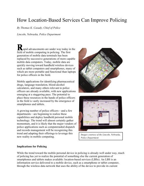
Images courtesy <strong>of</strong> the Lincoln, Nebraska,<br />
Police Department<br />
While the trend toward the mobile personal device in policing is already well under way, much<br />
<strong>of</strong> policing has yet to realize the potential <strong>of</strong> something else the current generation <strong>of</strong><br />
smartphones and tablets makes available: location-based services (LBSs). An LBS is an<br />
information service delivered to a mobile device, such as a smartphone or tablet computer,<br />
through the wireless data network that uses the ability <strong>of</strong> the device to provide its current
geographic position. The implications for policing are huge. To understand these implications,<br />
consider a common need: locating a restaurant for a good pizza.<br />
Think for a moment about how the task <strong>of</strong> finding a good pizza in an unfamiliar city has<br />
changed. Thirty years ago, a person might have checked phonebook listings and picked up a free<br />
road map at the gas station. Fifteen years ago, a person might have selected a restaurant after<br />
reading an online review. Ten years ago, a person might have used an online mapping site to<br />
print directions or might have used an expensive navigation system to lead the way.<br />
Today, individuals can simply type or speak ―pizza‖ into their mobile devices. In many cases, the<br />
keyword or voice search will launch a mobile map application and will populate the map with<br />
pushpins representing pizza restaurants in the vicinity. Individuals can click any pin for the<br />
business name, a hyperlink to its website, a link to restaurant reviews, and even a street-level<br />
photo <strong>of</strong> the business and its surroundings. Moreover, since the device is global positioning<br />
system (GPS)–enabled, the map updates and moves with users as they drive, ride, or walk, and<br />
more pushpins pop up as users near additional pizza places.<br />
This pizza search merges wireless data, the Internet, geocoded business data, the underlying<br />
mapping application, and the GPS receiver in the smartphone or the tablet. Although many<br />
implementations <strong>of</strong> LBSs use a map as the interface, this is not the case for every location-based<br />
application. For example, a weather application that delivers current conditions and forecasts<br />
based on the GPS coordinates <strong>of</strong> the device is an LBS with no map, as is an application that<br />
delivers the schedule at nearby movie theaters. LBSs have rapidly become ubiquitous. This is<br />
how hundreds <strong>of</strong> thousands <strong>of</strong> travelers will find bike shops, Thai food, ATMs, and<br />
brewpubs today.<br />
LBSs have tremendous potential in policing. Hundreds <strong>of</strong> police departments in the United States<br />
have already developed automated processes for geocoding crime and incident data in order to<br />
feed Internet and intranet mapping applications. These data are typically hosted ―in the cloud‖ on<br />
web servers rather than locally on individual personal computers. There is no reason these data<br />
cannot be provided as LBSs for the police. The technology is exactly the same as that used on<br />
tablets and on smartphones for locating shoe repair shops, wineries, and auto parts stores, among<br />
other locations.<br />
Case Study: Lincoln, Nebraska, Police Department<br />
It was this realization that caused the Lincoln, Nebraska, Police Department, in collaboration<br />
with the <strong>University</strong> <strong>of</strong> Nebraska, to develop its first LBS application. Proactive Police Patrol<br />
Information (P3i) is a location-based service that provides police points <strong>of</strong> interest (POI) to<br />
Lincoln police <strong>of</strong>ficers. Supported by funding from the National Institute <strong>of</strong> Justice, the police<br />
department and the <strong>University</strong> <strong>of</strong> Nebraska’s Public Policy Center and Department <strong>of</strong> Computer<br />
Science and Engineering are studying the impact <strong>of</strong> this technology on the work <strong>of</strong> Lincoln<br />
police <strong>of</strong>ficers.
This application delivers LBSs consisting <strong>of</strong> the addresses <strong>of</strong> wanted persons, recently issued<br />
arrest warrants, registered sex <strong>of</strong>fenders, parolees, gang members, and the locations <strong>of</strong> recent<br />
crimes to Lincoln police <strong>of</strong>ficers. The data appear on <strong>of</strong>ficers’ wireless devices without any<br />
effort on the <strong>of</strong>ficers’ part aside from starting the application—if it is not already running. The<br />
map moves as the <strong>of</strong>ficer moves, displaying the POIs in the immediate vicinity based on the<br />
coordinates provided by the GPS.<br />
The P3i application has been designed to operate on Apple’s iOS, the Google Android operating<br />
system, or as a basic web application for any GPS-equipped laptop computer, including the<br />
laptops the department presently uses as mobile data computers mounted in its marked patrol<br />
fleet. The application is currently deployed on all <strong>of</strong> these types <strong>of</strong> devices to an experimental<br />
group comprising 75 <strong>of</strong>ficers, with 15 each on 5 devices: Android tablets, Android smartphones,<br />
Apple iPads, Apple iPhones, and mobile data computers in patrol cars.<br />
Research is under way to study the relative merits <strong>of</strong> each, the technology uptake by the<br />
participating <strong>of</strong>ficers, and the ways in which this capability impacts the work <strong>of</strong> police <strong>of</strong>ficers.<br />
The research team hypothesizes that <strong>of</strong>ficers equipped with this technology will collect more<br />
information and intelligence in the field, arrest more wanted persons, and make more contacts<br />
with parolees and registered sex <strong>of</strong>fenders. This technology is also expected to reduce miles<br />
driven and fuel usage by <strong>of</strong>ficers equipped with P3i in comparison to a control group without this<br />
application. Qualitative data are also being gathered from surveys, focus groups, and web forms.<br />
Following data collection and analysis, the research team expects this technology will be<br />
deployed to a larger group <strong>of</strong> Lincoln police <strong>of</strong>ficers and incorporated into the<br />
department’s operations.<br />
While the current project focuses primarily on people—sex <strong>of</strong>fenders, parolees, and so forth—<br />
and delivers information about recent crimes near the user, there are many other types <strong>of</strong><br />
information that might be delivered to police <strong>of</strong>ficers as LBSs. Many data sets could be provided<br />
to <strong>of</strong>ficers as an LBS, such as premise history information and addresses flagged for known<br />
hazards. This technology has obvious applications in fire service and emergency medical<br />
services, such as by delivering information on the locations <strong>of</strong> stored hazardous materials, water<br />
mains, hydrants, and medically fragile patients. It has tremendous potential in community<br />
corrections for parole, probation, and other community supervision programs. Imagine an<br />
application that delivers the home, school, and work addresses <strong>of</strong> clients to probation <strong>of</strong>ficers as<br />
they move about the jurisdiction.<br />
Relevant to Users, Easy to Adopt<br />
<strong>Location</strong>-based services can take existing data and present them in a manner that is especially<br />
relevant to the user’s current spatial and temporal context. The information is delivered to users<br />
where they are located, while they are right there. Very little effort or interaction by the user is<br />
needed. The LBS pushes the relevant data to the user, rather than requiring that the user initiate<br />
the search and pull the information.
The technology <strong>of</strong> LBSs could be relatively easy to adopt for many agencies, particularly those<br />
that already maintain web services for Internet or intranet mapping applications. These agencies<br />
have already accomplished the most difficult aspects <strong>of</strong> creating a location-based service by<br />
developing processes to gather and geocode their data for use in desktop and web mapping<br />
s<strong>of</strong>tware. Web services and open application program interfaces make it easier than ever to<br />
deploy these data as an LBS, and bandwidth limitations that may have made applications like P3i<br />
impractical a few years ago are much less an issue today as more capable wireless<br />
networks proliferate.<br />
Tablet computers and smartphones have changed mobile computing almost overnight. As police<br />
<strong>of</strong>ficers and departments adapt these new capabilities to their needs, the leap forward will be<br />
game changing, just as the move from call box to mobile radio and from mobile radio to portable<br />
radio was for our predecessors. The deployment <strong>of</strong> LBSs for the police is likely to play a<br />
significant role in the future <strong>of</strong> mobile data in policing and may represent a watershed event in<br />
how information is delivered to <strong>of</strong>ficers in the field. ■<br />
Thomas K. Casady, "<strong>How</strong> <strong>Location</strong>-<strong>Based</strong> <strong>Services</strong> <strong>Can</strong> <strong>Improve</strong> <strong>Policing</strong>," The Police Chief 78<br />
(June 2011): 70–72.