Fugro-BKS: - University of Glasgow
Fugro-BKS: - University of Glasgow
Fugro-BKS: - University of Glasgow

Create successful ePaper yourself
Turn your PDF publications into a flip-book with our unique Google optimized e-Paper software.
Interview<br />
<strong>Fugro</strong>-<strong>BKS</strong>:<br />
The Dutch-based <strong>Fugro</strong> organisation with its numerous subsidiary<br />
companies is one <strong>of</strong> the leading service providers world-wide within the<br />
field <strong>of</strong> onshore and <strong>of</strong>fshore surveying and positioning. In 2007, a<br />
Geospatial Services business line was formed within its Survey Division,<br />
including acquisitions such as EarthData (U.S.A.), MAPS Geosystems (U.A.E.,<br />
Lebanon and Germany), and, more recently, <strong>BKS</strong>, one <strong>of</strong> the largest U.K.-based<br />
commercial surveying and mapping companies. Gordon Petrie asks Lynn Neill,<br />
Managing Director <strong>of</strong> <strong>Fugro</strong>-<strong>BKS</strong> and Regional Manager for <strong>Fugro</strong>'s aerial<br />
As most readers <strong>of</strong> GeoInformatics will be<br />
aware, the Dutch-based <strong>Fugro</strong> organisation with<br />
its numerous subsidiary companies is one <strong>of</strong><br />
the leading service providers world-wide within<br />
the field <strong>of</strong> onshore and <strong>of</strong>fshore surveying and<br />
positioning. In 2007, <strong>Fugro</strong> combined several<br />
<strong>of</strong> its existing onshore surveying and mapping<br />
companies to form a Geospatial Services business<br />
line within its Survey Division. Also included<br />
in the new business line were the EarthData<br />
(U.S.A.) and MAPS Geosystems (U.A.E.,<br />
Lebanon and Germany) companies that <strong>Fugro</strong><br />
had acquired during the same year. In April<br />
2008, in a further development, <strong>Fugro</strong> purchased<br />
<strong>BKS</strong>, one <strong>of</strong> the largest U.K.-based commercial<br />
surveying and mapping companies, and<br />
added it to the Geospatial Services group. A<br />
mapping business in Europe, all about this latest acquisition.<br />
Interview with Lynn Neill<br />
Part <strong>of</strong> <strong>Fugro</strong>’s Survey Division<br />
By Gordon Petrie<br />
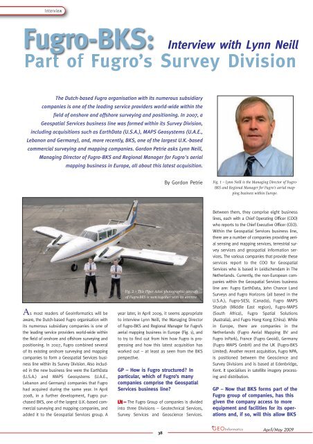
Fig. 2 – This Piper Aztec photographic aircraft<br />
<strong>of</strong> <strong>Fugro</strong>-<strong>BKS</strong> is seen together with its aircrew.<br />
year later, in April 2009, it seems appropriate<br />
to interview Lynn Neill, the Managing Director<br />
<strong>of</strong> <strong>Fugro</strong>-<strong>BKS</strong> and Regional Manager for <strong>Fugro</strong>’s<br />
aerial mapping business in Europe (Fig. 1), and<br />
to try to find out from him how <strong>Fugro</strong> is progressing<br />
and how this latest acquisition has<br />
worked out – at least as seen from the <strong>BKS</strong><br />
perspective.<br />
GP – How is <strong>Fugro</strong> structured? In<br />
particular, which <strong>of</strong> <strong>Fugro</strong>’s many<br />
companies comprise the Geospatial<br />
Services business line?<br />
The <strong>Fugro</strong> Group <strong>of</strong> companies is divided<br />
into three Divisions – Geotechnical Services,<br />
Survey Services and Geoscience Services.<br />
38<br />
Fig. 1 – Lynn Neill is the Managing Director <strong>of</strong> <strong>Fugro</strong>-<br />
<strong>BKS</strong> and Regional Manager for <strong>Fugro</strong>’s aerial mapping<br />
business within Europe.<br />
Between them, they comprise eight business<br />
lines, each with a Chief Operating Officer (COO)<br />
who reports to the Chief Executive Officer (CEO).<br />
Within the Geospatial Services business line,<br />
there are a number <strong>of</strong> companies providing aerial<br />
sensing and mapping services, terrestrial survey<br />
services and geospatial information services.<br />
The various companies that provide these<br />
services report to the COO for Geospatial<br />
Services who is based in Leidschendam in The<br />
Netherlands. Currently, the non-European companies<br />
within the Geospatial Services business<br />
line are: <strong>Fugro</strong> EarthData, John Chance Land<br />
Surveys and <strong>Fugro</strong> Horizons (all based in the<br />
U.S.A.), <strong>Fugro</strong>-SESL (Canada), <strong>Fugro</strong> MAPS<br />
Sharjah (Middle East region), <strong>Fugro</strong>-MAPS<br />
(South Africa), <strong>Fugro</strong> Spatial Solutions<br />
(Australia), and <strong>Fugro</strong> Hong Kong (China). While<br />
in Europe, there are companies in the<br />
Netherlands (<strong>Fugro</strong> Aerial Mapping BV and<br />
<strong>Fugro</strong> InPark), France (<strong>Fugro</strong> Geoid), Germany<br />
(<strong>Fugro</strong> MAPS GmbH) and the UK (<strong>Fugro</strong>-<strong>BKS</strong><br />
Limited). Another recent acquisition, <strong>Fugro</strong> NPA,<br />
is positioned between the Geoscience and<br />
Survey Divisions and is based at Edenbridge,<br />
Kent. It specialises in satellite imagery processing<br />
and distribution.<br />
GP – Now that <strong>BKS</strong> forms part <strong>of</strong> the<br />
<strong>Fugro</strong> group <strong>of</strong> companies, has this<br />
given the company access to more<br />
equipment and facilities for its operations<br />
and, if so, will this allow <strong>BKS</strong><br />
April/May 2009
to improve and expand the range <strong>of</strong><br />
products and services that it can<br />
<strong>of</strong>fer?<br />
Being part <strong>of</strong> the <strong>Fugro</strong> Group <strong>of</strong> companies<br />
has given <strong>Fugro</strong>-<strong>BKS</strong> (F-<strong>BKS</strong>) a muchimproved<br />
reach within the overall network <strong>of</strong><br />
<strong>Fugro</strong> companies. It also gives F-<strong>BKS</strong> access to<br />
the technology and equipment from the entire<br />
Geospatial group and from other business lines<br />
if necessary. For example, F-<strong>BKS</strong> now has direct<br />
access to two more aircraft for its operations<br />
within Europe (Fig. 2). In addition, there are a<br />
further 19 aerial mapping aircraft operating<br />
world-wide, not to mention those involved in<br />
Airborne Geophysics (within the Geoscience<br />
Division). Also, having access to technical support<br />
from experts in their relevant fields has<br />
given F-<strong>BKS</strong> a greater breadth <strong>of</strong> expertise<br />
when proposing solutions to clients.<br />
Furthermore, being able to <strong>of</strong>fer services from<br />
within other <strong>Fugro</strong> operating companies has<br />
given F-<strong>BKS</strong> another dimension. For example,<br />
if the survey has a hydrographic or <strong>of</strong>fshore<br />
survey component, then we can partner with a<br />
sister company from another business line to<br />
provide the complete services that the client<br />
may require.<br />
GP – Is there good potential for<br />
cooperation with the other Europeanbased<br />
mapping companies within<br />
the group – such as <strong>Fugro</strong> Aerial<br />
Mapping (NL), <strong>Fugro</strong>-MAPS<br />
Geosystems (D) and <strong>Fugro</strong>-Geoid (F)<br />
– and, if so, will this enable the<br />
group to bid for and undertake<br />
much larger mapping contracts than<br />
before?<br />
Latest News? Visit www.geoinformatics.com<br />
An objective <strong>of</strong> my role as Regional<br />
Manager for Europe Aerial Sensing and Mapping<br />
is to ensure the co-ordination <strong>of</strong> resources to<br />
realise the full potential that is available within<br />
the European-based companies. With this<br />
approach, the higher utilisation <strong>of</strong> expensive<br />
sensors and the possibilities <strong>of</strong> companies combining<br />
production personnel will enable the<br />
group to deliver more economic solutions to<br />
clients and also to deliver projects within programme<br />
for larger mapping contracts.<br />
GP – Besides <strong>BKS</strong>, <strong>Fugro</strong> has also<br />
acquired another U.K. company in<br />
the form <strong>of</strong> NPA, a specialist satellite<br />
mapping company. In the past, <strong>BKS</strong><br />
has utilized both airborne and satellite<br />
imagery extensively for work<br />
within the telecommunications field,<br />
39<br />
Interview<br />
Fig. 3 – This digital terrain model (DTM) <strong>of</strong> part<br />
<strong>of</strong> the island <strong>of</strong> Skellig Michael –<br />
which lies 12 km <strong>of</strong>f the south-west<br />
coast <strong>of</strong> Ireland – is based on the<br />
airborne laser scan data<br />
acquired by a FLI-MAP system.<br />
The model shows the beehive-shaped<br />
stone cells <strong>of</strong> the monks who<br />
inhabited this island monastery<br />
a thousand years ago.<br />
e.g. for RF Engineering & Network<br />
Design. Again is there scope for<br />
cooperation and expansion within<br />
the overall field <strong>of</strong> remote sensing<br />
image processing and applications<br />
using the combined resources <strong>of</strong> the<br />
two companies?<br />
The acquisition <strong>of</strong> NPA by <strong>Fugro</strong> brings to<br />
the <strong>Fugro</strong> Group a specialist satellite remote<br />
sensing company, with a broader capability than<br />
F-<strong>BKS</strong> in the sourcing and processing <strong>of</strong> satellite<br />
imagery. However, F-<strong>BKS</strong> does have extensively<br />
experienced technicians, familiar with the<br />
interpretation and creation <strong>of</strong> databases using<br />
high-resolution satellite imagery. Having <strong>Fugro</strong><br />
NPA to support the processing <strong>of</strong> satellite<br />
imagery from a varied range <strong>of</strong> sensors has<br />
been a great advantage and brings the knowl-<br />
Fig. 4 – This 3D model <strong>of</strong> part <strong>of</strong> the city <strong>of</strong> Belfast, Northern Ireland has been produced by<br />
stereo-photogrammetric measurement <strong>of</strong> aerial photography.<br />
April/May 2009
Interview<br />
Fig. 5 – The controller box and touch-screen based operator display <strong>of</strong> the Z/I In-Flight flight management system<br />
(at left) is interfaced to the Intergraph DMC digital frame camera with its solid-state disk that is mounted on a<br />
Z/I T-AS gyro-controlled mount (at right).<br />
edge <strong>of</strong> what is available more easily to the<br />
technical teams within all <strong>of</strong> <strong>Fugro</strong>‘s business<br />
lines.<br />
GP – Even before the acquisition <strong>of</strong><br />
<strong>BKS</strong> by <strong>Fugro</strong>, there was a close<br />
cooperation between the two organisations<br />
in the field <strong>of</strong> airborne laser<br />
scanning using the <strong>Fugro</strong> FLI-MAP<br />
systems. With the development <strong>of</strong><br />
the new FLI-MAP 1000 laser scanning<br />
system, will this lead to a further<br />
expansion <strong>of</strong> the services that<br />
can be <strong>of</strong>fered by <strong>Fugro</strong>-<strong>BKS</strong>?<br />
Since 2002, <strong>BKS</strong> has been the sole agent<br />
for the <strong>Fugro</strong> FLI-MAP system in the UK and<br />
Ireland and, over this period <strong>of</strong> time, a good<br />
working relationship has been developed<br />
between <strong>Fugro</strong> Aerial Mapping (FAM) in Holland<br />
and F-<strong>BKS</strong>. Most <strong>of</strong> the work undertaken since<br />
2002 has been executed using helicopters and<br />
the FLI-MAP system for the collection <strong>of</strong> high<br />
density point clouds for corridor mapping along<br />
linear features such as power lines, railways,<br />
highways, flood defences, etc. (Fig. 3). With the<br />
development <strong>of</strong> the new FLI-MAP 1000 laser<br />
scanning system, this system can be mounted<br />
in a fixed-wing aircraft and collect point clouds<br />
<strong>of</strong> up to 4 to 5 points per sq. m. along a corridor<br />
width <strong>of</strong> just over 1 km. This means that F-<br />
<strong>BKS</strong> can start to provide services over larger<br />
areas for a wider range <strong>of</strong> uses.<br />
GP – For quite a number <strong>of</strong> years,<br />
<strong>BKS</strong> undertook a great deal <strong>of</strong> photogrammetric<br />
work in the U.S.A. as a<br />
partner <strong>of</strong> or sub-contractor to<br />
EarthData Inc.. Since then, EarthData<br />
has developed a large low-cost data<br />
processing centre in China. Recently,<br />
as noted above, EarthData has also<br />
become part <strong>of</strong> the world-wide <strong>Fugro</strong><br />
group. Is the availability <strong>of</strong> this<br />
large data processing centre within<br />
the group likely to affect the size<br />
and scale <strong>of</strong> the existing <strong>BKS</strong> facility<br />
in Northern Ireland and the type <strong>of</strong><br />
work that it can or will undertake?<br />
The relationship between <strong>BKS</strong> and<br />
EarthData goes back to the mid-1980s, when<br />
the previous owner, Bryan Logan, who was a<br />
past managing director <strong>of</strong> <strong>BKS</strong>, established the<br />
EarthData company in Maryland, U.S.A. Over<br />
the years, EarthData and <strong>BKS</strong> did co-operate<br />
on many projects worldwide. So, when<br />
EarthData established a production centre in<br />
China, <strong>BKS</strong> was very much involved in training<br />
and in outsourcing work to that facility. Even<br />
though an increasing amount <strong>of</strong> work is outsourced<br />
by <strong>Fugro</strong>-<strong>BKS</strong> to China, the company<br />
has retained its full capability in all aspects <strong>of</strong><br />
photogrammetry, GIS and data processing within<br />
the production facility in Coleraine. Indeed<br />
some projects are executed entirely within the<br />
Coleraine facility, so no downsizing has taken<br />
place (Fig. 4). With the continuing development<br />
<strong>of</strong> new sensors and client demands, the existing<br />
resources are continually being challenged.<br />
If it means that we can deliver better value to<br />
a customer or a faster turn-around time, then<br />
we look to combine the resources in China with<br />
the expertise at F-<strong>BKS</strong> – or (with the client’s<br />
consent) other resources and expertise that are<br />
available anywhere else within the <strong>Fugro</strong> family.<br />
GP – A year ago, <strong>BKS</strong> acquired its<br />
first airborne digital imager in the<br />
40<br />
shape <strong>of</strong> an Intergraph DMC largeformat<br />
frame camera. What has been<br />
your experience with the new digital<br />
imaging technology?<br />
2008 was the first year that <strong>BKS</strong> used the<br />
DMC large-format camera (Fig. 5). Despite the<br />
inclement weather conditions throughout the<br />
summer period, we still had a very successful<br />
image acquisition programme with only two<br />
projects having to be carried over to 2009. The<br />
digital technology contributed to this success,<br />
since we were flying in conditions that normally<br />
would not have been acceptable using the<br />
analogue film camera. Some teething problems<br />
were encountered with the data storage units.<br />
Also <strong>BKS</strong> had to become accustomed to a new<br />
mission planning s<strong>of</strong>tware, which took some<br />
time to settle down. However the experience<br />
gained from flying with analogue film cameras<br />
over the years meant that the transition was<br />
very smooth.<br />
GP – While <strong>BKS</strong> has adopted airborne<br />
digital frame imaging, your US<br />
partner EarthData adopted the alternative<br />
pushbroom imaging technology.<br />
Was this difference in approach<br />
between the two companies due to<br />
the scale <strong>of</strong> investment that was<br />
needed or the need to change the<br />
subsequent photogrammetric processing<br />
or simply the fact that the<br />
two companies markets and requirements<br />
on each side <strong>of</strong> the Atlantic<br />
are very different?<br />
There were several factors taken into consideration<br />
before purchasing the DMC large-format<br />
frame camera, some <strong>of</strong> which I will expand<br />
on. Firstly the North American market is very<br />
different to that in the U.K. & Ireland due to the<br />
fact that, in the U.S.A., most state-wide mapping<br />
programmes are collected at an image resolution<br />
<strong>of</strong> 10 or 20 cm, which would be similar<br />
to the resolutions collected by the national<br />
mapping agencies in the U.K. & Ireland. Since<br />
this imagery is already catered for in the U.K.<br />
and Ireland, F-<strong>BKS</strong> therefore focuses mostly on<br />
higher resolution imagery in the 4 to 5 cm<br />
range, where the imagery is used more for engineering-type<br />
projects – i.e. for infrastructure<br />
design or utility mapping. When we started the<br />
process <strong>of</strong> evaluation, the frame cameras were<br />
more comfortable in achieving these resolutions.<br />
Secondly, having already established a<br />
digital flow line based on the scanning <strong>of</strong> analogue<br />
frame camera imagery, it would have<br />
meant changing the subsequent photogrammetric<br />
processing for aerial triangulation correlation,<br />
etc., so production processes could have<br />
been increasingly interrupted. F-<strong>BKS</strong> therefore<br />
April/May 2009
ecognised that it was necessary to select the<br />
technology that best meets the needs <strong>of</strong> the<br />
end client and also ensures smooth integration<br />
into existing production flow lines so that client<br />
programmes could be delivered on time. Within<br />
the <strong>Fugro</strong> Geospatial Services business line,<br />
there is a wealth <strong>of</strong> knowledge in both pushbroom<br />
and frame camera imaging systems, so<br />
expert advice is available on all operational<br />
aspects from within the group.<br />
GP – Besides the changeover to airborne<br />
digital imaging, your company<br />
has replaced the large battery <strong>of</strong><br />
analytical plotters that used to form<br />
the backbone <strong>of</strong> its photogrammetric<br />
capabilities with a number <strong>of</strong> digital<br />
photogrammetric workstations<br />
(DPWs). Has this been an easy conversion<br />
to implement and manage<br />
Latest News? Visit www.geoinformatics.com<br />
and has the large investment in the<br />
technology and in the re-training <strong>of</strong><br />
staff been worthwhile?<br />
<strong>BKS</strong> has had a good reputation in photogrammetry,<br />
going back to the 1970s and,<br />
indeed, as many as 14 analytical plotters, all<br />
working on a two-shift system, formed the<br />
backbone <strong>of</strong> the photogrammetric department.<br />
These analytical plotters have now all been<br />
replaced with DPWs, comprising three Z/I<br />
ImageStations, three Z/I SSKs and eight DAT/EM<br />
Summit Evolution workstations. These 14 DPWs<br />
now contribute to the complete data collection<br />
process within F-<strong>BKS</strong> (Fig. 6). Only two analytical<br />
plotters have been retained and they are<br />
only used occasionally. Initially the experienced<br />
photogrammetric operators, accustomed to<br />
working with hand-wheels on analytical plotters,<br />
felt that they did not have the same con-<br />
41<br />
Interview<br />
Fig. 6 – These digital photogrammetric<br />
workstations (DPWs) are shown in<br />
operational use in the mapping facility <strong>of</strong><br />
<strong>Fugro</strong>-<strong>BKS</strong> in Coleraine, Northern Ireland.<br />
trol <strong>of</strong> the floating mark using the 3D<br />
S<strong>of</strong>tMouse. However, after a short period <strong>of</strong><br />
time, they grew accustomed to the new system<br />
and could see the benefit <strong>of</strong> the more efficient<br />
digital technology, particularly with the set-up<br />
<strong>of</strong> stereo-pairs and in the semi-automatic processes<br />
used in data collection.<br />
<strong>BKS</strong> had identified the need for change and<br />
investment in order to remain competitive in<br />
the mapping industry, so the decision was<br />
made 10 years ago to start the investment process<br />
which has proved to be very successful.<br />
Those companies that have not embraced the<br />
digital technology have struggled to maintain<br />
market share in a changing and demanding<br />
marketplace.<br />
Gordon Petrie is Emeritus Pr<strong>of</strong>essor <strong>of</strong> Topographic<br />
Science in the Dept. <strong>of</strong> Geographical & Earth Sciences<br />
<strong>of</strong> the <strong>University</strong> <strong>of</strong> <strong>Glasgow</strong>, Scotland, U.K. E-mail -<br />
Gordon.Petrie@ges.gla.ac.uk<br />
April/May 2009