Site Allocations Assessment Criteria Site Reference - Amazon Web ...
Site Allocations Assessment Criteria Site Reference - Amazon Web ...
Site Allocations Assessment Criteria Site Reference - Amazon Web ...

You also want an ePaper? Increase the reach of your titles
YUMPU automatically turns print PDFs into web optimized ePapers that Google loves.
1. <strong>Site</strong><br />
2. Status<br />
3.<br />
Constraints<br />
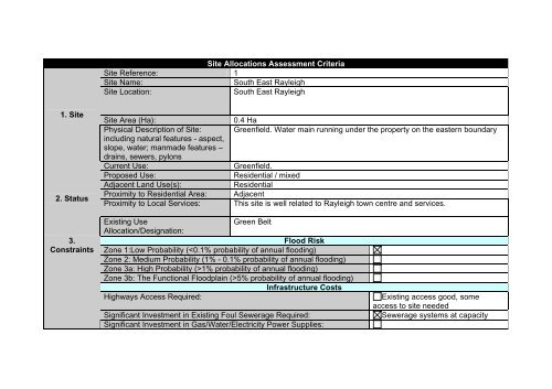
<strong>Site</strong> <strong>Allocations</strong> <strong>Assessment</strong> <strong>Criteria</strong><br />
<strong>Site</strong> <strong>Reference</strong>: 1<br />
<strong>Site</strong> Name: South East Rayleigh<br />
<strong>Site</strong> Location: South East Rayleigh<br />
<strong>Site</strong> Area (Ha): 0.4 Ha<br />
Physical Description of <strong>Site</strong>:<br />
including natural features - aspect,<br />
slope, water; manmade features –<br />
drains, sewers, pylons<br />
Greenfield. Water main running under the property on the eastern boundary<br />
Current Use: Greenfield.<br />
Proposed Use: Residential / mixed<br />
Adjacent Land Use(s): Residential<br />
Proximity to Residential Area: Adjacent<br />
Proximity to Local Services: This site is well related to Rayleigh town centre and services.<br />
Existing Use<br />
Green Belt<br />
Allocation/Designation:<br />
Flood Risk<br />
Zone 1:Low Probability (1% probability of annual flooding)<br />
Zone 3b: The Functional Floodplain (>5% probability of annual flooding)<br />
Infrastructure Costs<br />
Highways Access Required: Existing access good, some<br />
access to site needed<br />
Significant Investment in Existing Foul Sewerage Required: Sewerage systems at capacity<br />
Significant Investment in Gas/Water/Electricity Power Supplies:
4. Potential<br />
Impact<br />
5. Potential<br />
Uses<br />
Significant Investment in walking/public transport required:<br />
Flood Risk Mitigation Measures Required:<br />
Environmental<br />
Within/Proximity to SSSI:<br />
Within/Proximity Conservation Area:<br />
Within/Proximity Green Belt:<br />
Within/Proximity SPA:<br />
Within/Proximity SAC:<br />
Within/Proximity LNR:<br />
Within/Proximity LoWS:<br />
Within/Proximity SLA:<br />
Within/Proximity TPO:<br />
Within/Proximity MSA:<br />
Within/Proximity Listed Buildings:<br />
Pollution<br />
<strong>Site</strong> located within/in proximity to:<br />
AQMA:<br />
Pollution Source:<br />
Known contaminated area:<br />
Within/Proximity area Archaeological interest:<br />
Development will affect existing recreational use/right of way:<br />
Likely loss of character of site:<br />
Likely loss of significant views into/out of site:<br />
Development will have negative impacts on area:<br />
Residential:<br />
Retail:<br />
Employment:<br />
Industrial:
Leisure/Recreation:<br />
Mixed:<br />
Gypsy and Traveller <strong>Site</strong>:<br />
Potential Capacity<br />
Residential 12-14 dwellings<br />
Gypsy and Traveller <strong>Site</strong><br />
Sustainability Objectives<br />
To ensure the delivery of high quality sustainable communities where<br />
people will want to live and work<br />
To create safe environments where crime and disorder or fear of crime<br />
does not undermine the quality of life or community cohesion<br />
To provide everyone with the opportunity to live in a decent home<br />
To improve the health of residents and mitigate/reduce potential health<br />
inequalities arising from new development<br />
Dependent on use<br />
To promote town centre vitality and viability<br />
To achieve sustainable levels of prosperity and economic growth<br />
To conserve and enhance the biological and geological diversity of the<br />
environment as an integral part of social, environmental, and economic<br />
development<br />
To promote more sustainable transport choices both for people and<br />
moving freight<br />
To promote accessibility to jobs, shopping, leisure facilities and services by<br />
public transport, cycling and walking<br />
To improve the education and skills of the population Dependent on use<br />
To maintain and enhance cultural heritage and assets<br />
To reduce contributions to climate change<br />
To improve water quality<br />
To reduce the risk of flooding<br />
To improve air quality
6.<br />
Timescales<br />
Year in which first dwelling/use could be built on site:<br />
Number of dwellings/uses to be built per year:<br />
Year in which final dwellings/use will be completed:<br />
Automatic Exclusion (SSSI etc)<br />
Unknown<br />
Unknown<br />
Unknown<br />
Further Consideration: Development of this site would be Infill of existing development, which is<br />
currently against Council policy. Little investment would be needed other<br />
than in the sewerage system serving the site. Good access to local services<br />
7.<br />
Conclusion<br />
and shops, and public transport. However the contribution this site can make<br />
in terms of housing targets is minimal, and as such the community benefits<br />
would be negligible.
Source: Google Maps
1. <strong>Site</strong><br />
2. Status<br />
3.<br />
Constraints<br />
<strong>Site</strong> <strong>Allocations</strong> <strong>Assessment</strong> <strong>Criteria</strong><br />
<strong>Site</strong> <strong>Reference</strong>: 2<br />
<strong>Site</strong> Name: Land opposite Barling Magna primary school<br />
<strong>Site</strong> Location: Barling<br />
<strong>Site</strong> Area (Ha): 0.81Ha<br />
Physical Description of <strong>Site</strong>: No visible constraints. No visible pylons. Farmed arable land.<br />
including natural features - aspect,<br />
slope, water; manmade features –<br />
drains, sewers, pylons<br />
Current Use: Farmed arable Land.<br />
Proposed Use: Residential<br />
Adjacent Land Use(s): School and Arable farmland<br />
Proximity to Residential Area: Adjacent<br />
Proximity to Local Services: The site is adjacent to a primary school. However, limited public transport<br />
and services within proximity to site.<br />
Existing Use<br />
Green Belt<br />
Allocation/Designation:<br />
Flood Risk<br />
Zone 1:Low Probability (1% probability of annual flooding)<br />
Zone 3b: The Functional Floodplain (>5% probability of annual flooding)<br />
Infrastructure Costs<br />
Highways Access Required: Existing access good, some<br />
access to site needed<br />
Significant Investment in Existing Foul Sewerage Required:<br />
Significant Investment in Gas/Water/Electricity Power Supplies:
4. Potential<br />
Impact<br />
Significant Investment in walking/public transport required: More regular bus service, more<br />
footpaths<br />
Flood Risk Mitigation Measures Required: SFRA required as site is in Flood<br />
Risk Zone 3a<br />
Environmental<br />
Within/Proximity to SSSI:<br />
Within/Proximity Conservation Area:<br />
Within/Proximity Green Belt:<br />
Within/Proximity SPA:<br />
Within/Proximity SAC:<br />
Within/Proximity LNR:<br />
Within/Proximity LoWS:<br />
Within/Proximity SLA:<br />
Within/Proximity TPO:<br />
Within/Proximity MSA:<br />
Within/Proximity Listed Buildings:<br />
Pollution<br />
<strong>Site</strong> located within/in proximity to:<br />
AQMA:<br />
Pollution Source:<br />
Known contaminated area:<br />
Within/Proximity area Archaeological interest:<br />
Development will affect existing recreational use/right of way:<br />
Likely loss of character of site:<br />
Likely loss of significant views into/out of site:<br />
Development will have negative impacts on area: Potential negative environmental<br />
impacts<br />
5. Potential Residential:
Uses<br />
Retail:<br />
Employment:<br />
Industrial:<br />
Leisure/Recreation:<br />
Mixed:<br />
Gypsy and Traveller <strong>Site</strong>:<br />
Potential Capacity<br />
Residential 18 – 22 dwellings<br />
Gypsy and Traveller <strong>Site</strong><br />
Sustainability Objectives<br />
To ensure the delivery of high quality sustainable communities where<br />
people will want to live and work<br />
To create safe environments where crime and disorder or fear of crime subject to design and planning<br />
does not undermine the quality of life or community cohesion<br />
conditions<br />
To provide everyone with the opportunity to live in a decent home<br />
To improve the health of residents and mitigate/reduce potential health<br />
inequalities arising from new development<br />
To promote town centre vitality and viability<br />
To achieve sustainable levels of prosperity and economic growth<br />
To conserve and enhance the biological and geological diversity of the<br />
environment as an integral part of social, environmental, and economic<br />
development<br />
To promote more sustainable transport choices both for people and<br />
moving freight<br />
To promote accessibility to jobs, shopping, leisure facilities and services by<br />
public transport, cycling and walking<br />
To improve the education and skills of the population<br />
To maintain and enhance cultural heritage and assets<br />
To reduce contributions to climate change
6.<br />
Timescales<br />
To improve water quality<br />
To reduce the risk of flooding<br />
To improve air quality<br />
Year in which first dwelling/use could be built on site:<br />
Number of dwellings/uses to be built per year:<br />
Year in which final dwellings/use will be completed:<br />
Unknown<br />
Unknown<br />
Unknown<br />
7.<br />
Conclusion<br />
Automatic Exclusion (SSSI etc)<br />
Further Consideration: Flood Zone 3 indicating SFRA required. <strong>Site</strong> unlikely to pass PPS25<br />
sequential test in relation to flood risk, due to the availability of alternative<br />
potential greenfield sites in the District. The flood mitigation measures<br />
required may challenge the viability of development. This site is not situated<br />
in a proposed strategic location for housing as set out in the Core Strategy,<br />
as it is located in a lower tier settlement and in a location which is not in close<br />
proximity to services and facilities. The site would offer minimal contribution<br />
in terms of community benefit and housing targets.
Source: Google Maps
1. <strong>Site</strong><br />
2. Status<br />
3.<br />
Constraints<br />
<strong>Site</strong> <strong>Allocations</strong> <strong>Assessment</strong> <strong>Criteria</strong><br />
<strong>Site</strong> <strong>Reference</strong>: 3<br />
<strong>Site</strong> Name: Wallasea Marina/Intertidal defence/Wetland Habitat<br />
<strong>Site</strong> Location: Wallasea Island<br />
<strong>Site</strong> Area (Ha): 32 Ha (8Ha marina and 24Ha inter tidal defence and wetland habitat)<br />
Physical Description of <strong>Site</strong>:<br />
including natural features - aspect,<br />
slope, water; manmade features –<br />
drains, sewers, pylons<br />
Wetland habitat, arable farming. No visible pylons. Selection of buildings to<br />
the south of the site.<br />
Current Use: Arable land<br />
Proposed Use: Employment (Marina, Sea Defence and Inter Tidal Wetland Habitat)<br />
Adjacent Land Use(s): Marina, arable land<br />
Proximity to Residential Area: Nearest residential dwelling is in East Canewdon<br />
Proximity to Local Services: There are limited services within proximity to site.<br />
Existing Use<br />
Green Belt/SSSI<br />
Allocation/Designation:<br />
Flood Risk<br />
Zone 1:Low Probability (1% probability of annual flooding)<br />
Zone 3b: The Functional Floodplain (>5% probability of annual flooding)<br />
Infrastructure Costs<br />
Highways Access Required:<br />
Significant Investment in Existing Foul Sewerage Required:<br />
Significant Investment in Gas/Water/Electricity Power Supplies:<br />
Significant Investment in walking/public transport required:<br />
Flood Risk Mitigation Measures Required:
4. Potential<br />
Impact<br />
5. Potential<br />
Uses<br />
Within/Proximity to SSSI:<br />
Within/Proximity Conservation Area:<br />
Within/Proximity Green Belt:<br />
Within/Proximity SPA:<br />
Within/Proximity SAC:<br />
Within/Proximity LNR:<br />
Within/Proximity LoWS:<br />
Within/Proximity SLA:<br />
Within/Proximity TPO:<br />
Within/Proximity MSA:<br />
Within/Proximity Listed Buildings:<br />
Environmental<br />
Pollution<br />
<strong>Site</strong> located within/in proximity to:<br />
AQMA:<br />
Pollution Source:<br />
Known contaminated area:<br />
Within/Proximity area Archaeological interest:<br />
Development will affect existing recreational use/right of way:<br />
Likely loss of character of site:<br />
Likely loss of significant views into/out of site:<br />
Development will have negative impacts on area:<br />
Residential:<br />
Retail:<br />
Employment:<br />
Industrial:<br />
Leisure/Recreation:<br />
Mixed:
Gypsy and Traveller <strong>Site</strong>:<br />
Potential Capacity<br />
Residential<br />
Gypsy and Traveller <strong>Site</strong><br />
Sustainability Objectives<br />
To ensure the delivery of high quality sustainable communities where<br />
people will want to live and work<br />
To create safe environments where crime and disorder or fear of crime<br />
does not undermine the quality of life or community cohesion<br />
To provide everyone with the opportunity to live in a decent home<br />
To improve the health of residents and mitigate/reduce potential health<br />
inequalities arising from new development<br />
To promote town centre vitality and viability<br />
To achieve sustainable levels of prosperity and economic growth<br />
To conserve and enhance the biological and geological diversity of the<br />
environment as an integral part of social, environmental, and economic<br />
development<br />
Research needed on full impacts<br />
of marina<br />
To promote more sustainable transport choices both for people and<br />
moving freight<br />
To promote accessibility to jobs, shopping, leisure facilities and services by<br />
public transport, cycling and walking<br />
To improve the education and skills of the population<br />
To maintain and enhance cultural heritage and assets<br />
To reduce contributions to climate change Potential dependant on design and<br />
planning conditions<br />
To improve water quality<br />
To reduce the risk of flooding<br />
To improve air quality<br />
6. Year in which first dwelling/use could be built on site: Unknown
Timescales<br />
7.<br />
Conclusion<br />
Number of dwellings/uses to be built per year: Unknown<br />
Year in which final dwellings/use will be completed: Unknown<br />
Automatic Exclusion (SSSI etc)<br />
Further Consideration: The site is relatively isolated but situated within a general location identified in<br />
the Core Strategy as having potential for recreational opportunities, principally<br />
in respect of the Wallasea Island Wild Coast Project. Whilst the tidal wetland<br />
habitat proposed may compliment this use, it is unclear whether the proposed<br />
allocation for marina would have a detrimental effect on the ecological<br />
sensitive areas it abuts, particularly those that are part of the Natura 2000<br />
network. If such an allocation were to be pursued, a detailed Habitats<br />
Regulation <strong>Assessment</strong> would have to be undertaken at project level.
Source: Google Maps
1. <strong>Site</strong><br />
2. Status<br />
3.<br />
Constraints<br />
<strong>Site</strong> <strong>Allocations</strong> <strong>Assessment</strong> <strong>Criteria</strong><br />
<strong>Site</strong> <strong>Reference</strong>: 4<br />
<strong>Site</strong> Name: Three Acres and Birch Lodge<br />
<strong>Site</strong> Location: Canewdon<br />
<strong>Site</strong> Area (Ha): 1.4 Ha<br />
Physical Description of <strong>Site</strong>:<br />
including natural features - aspect,<br />
slope, water; manmade features –<br />
drains, sewers, pylons<br />
Consists of 2 dwellings and a disused riding school. Several man made<br />
features on the site although no visible pylons.<br />
Current Use: Dwellings/Riding School Building<br />
Proposed Use: Residential<br />
Adjacent Land Use(s): Residential (East) Agricultural (West)<br />
Proximity to Residential Area: Adjacent<br />
Proximity to Local Services: The site is located on the outskirts of the main settlement and as such has<br />
limited access to services. The site is not within proximity of leisure facilities<br />
or schools, and has fair access to the highway network.<br />
Existing Use<br />
Green Belt<br />
Allocation/Designation:<br />
Flood Risk<br />
Zone 1:Low Probability (1% probability of annual flooding)<br />
Zone 3b: The Functional Floodplain (>5% probability of annual flooding)<br />
Infrastructure Costs<br />
Highways Access Required:<br />
Significant Investment in Existing Foul Sewerage Required:<br />
Significant Investment in Gas/Water/Electricity Power Supplies:
4. Potential<br />
Impact<br />
5. Potential<br />
Uses<br />
Significant Investment in walking/public transport required:<br />
Flood Risk Mitigation Measures Required:<br />
Environmental<br />
Within/Proximity to SSSI:<br />
Within/Proximity Conservation Area:<br />
Within/Proximity Green Belt:<br />
Within/Proximity SPA:<br />
Within/Proximity SAC:<br />
Within/Proximity LNR:<br />
Within/Proximity LoWS:<br />
Within/Proximity SLA:<br />
Within/Proximity TPO:<br />
Within/Proximity MSA:<br />
Within/Proximity Listed Buildings:<br />
Pollution<br />
<strong>Site</strong> located within/in proximity to:<br />
AQMA:<br />
Pollution Source:<br />
Known contaminated area:<br />
Within/Proximity area Archaeological interest:<br />
Development will affect existing recreational use/right of way:<br />
Likely loss of character of site:<br />
Likely loss of significant views into/out of site:<br />
Development will have negative impacts on area:<br />
Residential:<br />
Retail:<br />
Employment:<br />
Industrial:
Leisure/Recreation:<br />
Mixed:<br />
Gypsy and Traveller <strong>Site</strong>:<br />
Potential Capacity<br />
Residential 42 – 53 dwellings<br />
Gypsy and Traveller <strong>Site</strong><br />
Sustainability Objectives<br />
To ensure the delivery of high quality sustainable communities where<br />
people will want to live and work<br />
To create safe environments where crime and disorder or fear of crime<br />
does not undermine the quality of life or community cohesion<br />
To provide everyone with the opportunity to live in a decent home<br />
To improve the health of residents and mitigate/reduce potential health<br />
inequalities arising from new development<br />
To promote town centre vitality and viability<br />
To achieve sustainable levels of prosperity and economic growth<br />
To conserve and enhance the biological and geological diversity of the<br />
environment as an integral part of social, environmental, and economic<br />
development<br />
To promote more sustainable transport choices both for people and<br />
moving freight<br />
To promote accessibility to jobs, shopping, leisure facilities and services by<br />
public transport, cycling and walking<br />
To improve the education and skills of the population<br />
To maintain and enhance cultural heritage and assets<br />
To reduce contributions to climate change<br />
To improve water quality<br />
To reduce the risk of flooding<br />
To improve air quality<br />
Subject to Design and Planning<br />
condition
6.<br />
Timescales<br />
Year in which first dwelling/use could be built on site:<br />
Number of dwellings/uses to be built per year:<br />
Year in which final dwellings/use will be completed:<br />
Automatic Exclusion (SSSI etc)<br />
2010<br />
50<br />
2011<br />
Further Consideration: The site is situated within the strategic location identified in the Core Strategy<br />
for residential development, and it has the potential to provide affordable<br />
housing for Canewdon. The capacity of the site is such that the housing<br />
7.<br />
Conclusion<br />
target as set in the Core Strategy can be met, and as such, suitable<br />
community benefits can also be obtained.
Source: Google Maps
1. <strong>Site</strong><br />
2. Status<br />
3.<br />
Constraints<br />
<strong>Site</strong> <strong>Allocations</strong> <strong>Assessment</strong> <strong>Criteria</strong><br />
<strong>Site</strong> <strong>Reference</strong>: Call for <strong>Site</strong>s <strong>Allocations</strong> 5<br />
<strong>Site</strong> Name: Daws Heath Road<br />
<strong>Site</strong> Location: North of Daws Heath Road<br />
<strong>Site</strong> Area (Ha): 0.81 Ha<br />
Physical Description of <strong>Site</strong>: Dwelling and Garden. Grazing land with buildings as stable.<br />
including natural features - aspect,<br />
slope, water; manmade features –<br />
drains, sewers, pylons<br />
Current Use: Residential / Grazing land<br />
Proposed Use: Residential<br />
Adjacent Land Use(s): Residential / grazing land<br />
Proximity to Residential Area: Adjacent<br />
Proximity to Local Services: This site is well related to Rayleigh town centre and services.<br />
Existing Use<br />
Green Belt<br />
Allocation/Designation:<br />
Flood Risk<br />
Zone 1:Low Probability (1% probability of annual flooding)<br />
Zone 3b: The Functional Floodplain (>5% probability of annual flooding)<br />
Infrastructure Costs<br />
Highways Access Required:<br />
Significant Investment in Existing Foul Sewerage Required:<br />
Significant Investment in Gas/Water/Electricity Power Supplies:<br />
Significant Investment in walking/public transport required:<br />
Flood Risk Mitigation Measures Required:
4. Potential<br />
Impact<br />
5. Potential<br />
Uses<br />
Within/Proximity to SSSI:<br />
Within/Proximity Conservation Area:<br />
Within/Proximity Green Belt:<br />
Within/Proximity SPA:<br />
Within/Proximity SAC:<br />
Within/Proximity LNR:<br />
Within/Proximity LoWS:<br />
Within/Proximity SLA:<br />
Within/Proximity TPO:<br />
Within/Proximity MSA:<br />
Within/Proximity Listed Buildings:<br />
Environmental<br />
Pollution<br />
<strong>Site</strong> located within/in proximity to:<br />
AQMA:<br />
Pollution Source:<br />
Known contaminated area:<br />
Within/Proximity area Archaeological interest:<br />
Development will affect existing recreational use/right of way:<br />
Likely loss of character of site:<br />
Likely loss of significant views into/out of site:<br />
Development will have negative impacts on area:<br />
Residential:<br />
Retail:<br />
Employment:<br />
Industrial:<br />
Leisure/Recreation:<br />
Mixed:
Gypsy and Traveller <strong>Site</strong>:<br />
Potential Capacity<br />
Residential 18 – 22 dwellings<br />
Gypsy and Traveller <strong>Site</strong><br />
Sustainability Objectives<br />
To ensure the delivery of high quality sustainable communities where<br />
people will want to live and work<br />
To create safe environments where crime and disorder or fear of crime<br />
does not undermine the quality of life or community cohesion<br />
To provide everyone with the opportunity to live in a decent home<br />
To improve the health of residents and mitigate/reduce potential health<br />
inequalities arising from new development<br />
To promote town centre vitality and viability<br />
To achieve sustainable levels of prosperity and economic growth<br />
To conserve and enhance the biological and geological diversity of the<br />
environment as an integral part of social, environmental, and economic<br />
development<br />
To promote more sustainable transport choices both for people and<br />
moving freight<br />
To promote accessibility to jobs, shopping, leisure facilities and services by<br />
public transport, cycling and walking<br />
To improve the education and skills of the population<br />
To maintain and enhance cultural heritage and assets<br />
To reduce contributions to climate change<br />
To improve water quality<br />
To reduce the risk of flooding<br />
To improve air quality<br />
6. Year in which first dwelling/use could be built on site: Unknown<br />
Timescales Number of dwellings/uses to be built per year: Unknown<br />
subject to design and planning<br />
conditions
7.<br />
Conclusion<br />
Year in which final dwellings/use will be completed: Unknown<br />
Automatic Exclusion (SSSI etc)<br />
Further Consideration: This site is not situated in a proposed strategic location for housing as set out<br />
in the emerging Core Strategy, as it would not contribute towards the<br />
balanced approach to housing distribution advocated in the emerging Core<br />
Strategy and there is a need to avoid the coalescence of Rayleigh with<br />
Southend. The site will also offer minimal contributions in terms of housing<br />
targets and community benefits.
Source: Google Maps
1. <strong>Site</strong><br />
2. Status<br />
3.<br />
Constraints<br />
<strong>Site</strong> <strong>Allocations</strong> <strong>Assessment</strong> <strong>Criteria</strong><br />
<strong>Site</strong> <strong>Reference</strong>: Call for <strong>Site</strong>s <strong>Allocations</strong> 6<br />
<strong>Site</strong> Name: Bull Lane<br />
<strong>Site</strong> Location: Bull Lane, Rayleigh<br />
<strong>Site</strong> Area (Ha): 0.132 Ha (site comprises two plots (630m 2 & 685m 2 )map below shows larger<br />
site in which these plots sit)<br />
Physical Description of <strong>Site</strong>: Fallow fields. Slight incline. Adjacent to residential development. No visible<br />
including natural features - aspect, pylons.<br />
slope, water; manmade features –<br />
drains, sewers, pylons<br />
Current Use: Greenfield<br />
Proposed Use: Residential<br />
Adjacent Land Use(s): Residential<br />
Proximity to Residential Area: Adjacent<br />
Proximity to Local Services: <strong>Site</strong> is well related to Rayleigh town centre and services.<br />
Existing Use<br />
Green Belt<br />
Allocation/Designation:<br />
Flood Risk<br />
Zone 1:Low Probability (1% probability of annual flooding)<br />
Zone 3b: The Functional Floodplain (>5% probability of annual flooding)<br />
Infrastructure Costs<br />
Highways Access Required:<br />
Significant Investment in Existing Foul Sewerage Required:<br />
Significant Investment in Gas/Water/Electricity Power Supplies:<br />
Significant Investment in walking/public transport required:
4. Potential<br />
Impact<br />
5. Potential<br />
Uses<br />
Flood Risk Mitigation Measures Required:<br />
Within/Proximity to SSSI:<br />
Within/Proximity Conservation Area:<br />
Within/Proximity Green Belt:<br />
Within/Proximity SPA:<br />
Within/Proximity SAC:<br />
Within/Proximity LNR:<br />
Within/Proximity LoWS:<br />
Within/Proximity SLA:<br />
Within/Proximity TPO:<br />
Within/Proximity MSA:<br />
Within/Proximity Listed Buildings:<br />
Environmental<br />
Pollution<br />
<strong>Site</strong> located within/in proximity to:<br />
AQMA:<br />
Pollution Source:<br />
Known contaminated area:<br />
Within/Proximity area Archaeological interest:<br />
Development will affect existing recreational use/right of way:<br />
Likely loss of character of site:<br />
Likely loss of significant views into/out of site:<br />
Development will have negative impacts on area:<br />
Residential:<br />
Retail:<br />
Employment:<br />
Industrial:<br />
Leisure/Recreation:
Mixed:<br />
Gypsy and Traveller <strong>Site</strong>:<br />
Potential Capacity<br />
Residential 2 dwellings<br />
Gypsy and Traveller <strong>Site</strong><br />
Sustainability Objectives<br />
To ensure the delivery of high quality sustainable communities where<br />
people will want to live and work<br />
To create safe environments where crime and disorder or fear of crime<br />
does not undermine the quality of life or community cohesion<br />
To provide everyone with the opportunity to live in a decent home<br />
To improve the health of residents and mitigate/reduce potential health<br />
inequalities arising from new development<br />
To promote town centre vitality and viability<br />
To achieve sustainable levels of prosperity and economic growth<br />
To conserve and enhance the biological and geological diversity of the<br />
environment as an integral part of social, environmental, and economic<br />
development<br />
To promote more sustainable transport choices both for people and<br />
moving freight<br />
To promote accessibility to jobs, shopping, leisure facilities and services by<br />
public transport, cycling and walking<br />
To improve the education and skills of the population<br />
To maintain and enhance cultural heritage and assets<br />
To reduce contributions to climate change<br />
To improve water quality<br />
To reduce the risk of flooding<br />
To improve air quality<br />
6. Year in which first dwelling/use could be built on site: Unknown<br />
subject to design and planning<br />
conditions
Timescales<br />
7.<br />
Conclusion<br />
Number of dwellings/uses to be built per year: Unknown<br />
Year in which final dwellings/use will be completed: Unknown<br />
Automatic Exclusion (SSSI etc)<br />
Further Consideration: The sites are not located within the broad locations as set out for housing<br />
development within the Core Strategy. The sites, as a result, would offer<br />
minimal community benefits and minimal contribution to housing targets.
Source: Google Maps
1. <strong>Site</strong><br />
2. Status<br />
3.<br />
Constraints<br />
<strong>Site</strong> <strong>Allocations</strong> <strong>Assessment</strong> <strong>Criteria</strong><br />
<strong>Site</strong> <strong>Reference</strong>: Call for <strong>Site</strong>s <strong>Allocations</strong> 8<br />
<strong>Site</strong> Name: Land off Folly Lane<br />
<strong>Site</strong> Location: Hockley<br />
<strong>Site</strong> Area (Ha): 0.2 Ha<br />
Physical Description of <strong>Site</strong>: Flat surface, garden<br />
including natural features - aspect,<br />
slope, water; manmade features –<br />
drains, sewers, pylons<br />
Current Use: Garden / Greenfield<br />
Proposed Use: Residential<br />
Adjacent Land Use(s): Residential and employment<br />
Proximity to Residential Area: adjacent<br />
Proximity to Local Services: The site is located in close proximity to Hockley centre and services.<br />
Existing Use<br />
Green Belt<br />
Allocation/Designation:<br />
Flood Risk<br />
Zone 1:Low Probability (1% probability of annual flooding)<br />
Zone 3b: The Functional Floodplain (>5% probability of annual flooding)<br />
Infrastructure Costs<br />
Highways Access Required:<br />
Significant Investment in Existing Foul Sewerage Required:<br />
Significant Investment in Gas/Water/Electricity Power Supplies:<br />
Significant Investment in walking/public transport required:<br />
Flood Risk Mitigation Measures Required:
4. Potential<br />
Impact<br />
5. Potential<br />
Uses<br />
Within/Proximity to SSSI:<br />
Within/Proximity Conservation Area:<br />
Within/Proximity Green Belt:<br />
Within/Proximity SPA:<br />
Within/Proximity SAC:<br />
Within/Proximity LNR:<br />
Within/Proximity LoWS:<br />
Within/Proximity SLA:<br />
Within/Proximity TPO:<br />
Within/Proximity MSA:<br />
Within/Proximity Listed Buildings:<br />
Environmental<br />
Pollution<br />
<strong>Site</strong> located within/in proximity to:<br />
AQMA:<br />
Pollution Source:<br />
Known contaminated area:<br />
Within/Proximity area Archaeological interest:<br />
Development will affect existing recreational use/right of way:<br />
Likely loss of character of site:<br />
Likely loss of significant views into/out of site:<br />
Development will have negative impacts on area:<br />
Residential:<br />
Retail:<br />
Employment:<br />
Industrial:<br />
Leisure/Recreation:<br />
Mixed:
Gypsy and Traveller <strong>Site</strong>:<br />
Potential Capacity<br />
Residential 8 dwellings<br />
Gypsy and Traveller <strong>Site</strong><br />
Sustainability Objectives<br />
To ensure the delivery of high quality sustainable communities where<br />
people will want to live and work<br />
To create safe environments where crime and disorder or fear of crime<br />
does not undermine the quality of life or community cohesion<br />
To provide everyone with the opportunity to live in a decent home<br />
To improve the health of residents and mitigate/reduce potential health<br />
inequalities arising from new development<br />
To promote town centre vitality and viability<br />
To achieve sustainable levels of prosperity and economic growth<br />
To conserve and enhance the biological and geological diversity of the<br />
environment as an integral part of social, environmental, and economic<br />
development<br />
To promote more sustainable transport choices both for people and<br />
moving freight<br />
To promote accessibility to jobs, shopping, leisure facilities and services by<br />
public transport, cycling and walking<br />
To improve the education and skills of the population<br />
To maintain and enhance cultural heritage and assets<br />
To reduce contributions to climate change<br />
To improve water quality<br />
To reduce the risk of flooding<br />
To improve air quality<br />
6. Year in which first dwelling/use could be built on site: Unknown<br />
Timescales Number of dwellings/uses to be built per year: Unknown<br />
subject to design and planning<br />
conditions
7.<br />
Conclusion<br />
Year in which final dwellings/use will be completed: Unknown<br />
Automatic Exclusion (SSSI etc)<br />
Further Consideration: The emerging Core Strategy does not advocate the allocation of land for any<br />
other uses within this area. The site would have to be developed as part of a<br />
larger site in order for the suitable contributions towards community benefits<br />
and housing targets to be made. The site has the capacity to contribute<br />
minimally towards housing targets.
Source: Google Maps
1. <strong>Site</strong><br />
2.Status<br />
3.<br />
Constraints<br />
<strong>Site</strong> <strong>Allocations</strong> <strong>Assessment</strong> <strong>Criteria</strong><br />
<strong>Site</strong> <strong>Reference</strong>: Call for <strong>Site</strong>s <strong>Allocations</strong> 9<br />
<strong>Site</strong> Name: Land south of Arundel Road between Lyndhurst Road and Hillsborough Road<br />
<strong>Site</strong> Location: Ashingdon<br />
<strong>Site</strong> Area (Ha): 3.64 Ha<br />
Physical Description of <strong>Site</strong>:<br />
including natural features - aspect,<br />
slope, water; manmade features –<br />
drains, sewers, pylons<br />
Disused fields. No visible pylons. Some fencing through the centre of the<br />
site, trees to the north of the site.<br />
Current Use: Garden/Fields<br />
Proposed Use: Residential<br />
Adjacent Land Use(s): Residential<br />
Proximity to Residential Area: Adjacent<br />
Proximity to Local Services: Close proximity to Ashingdon Primary School, but shops and services are not<br />
well located in relation to site.<br />
Existing Use<br />
Green Belt<br />
Allocation/Designation:<br />
Flood Risk<br />
Zone 1:Low Probability (1% probability of annual flooding)<br />
Zone 3b: The Functional Floodplain (>5% probability of annual flooding)<br />
Infrastructure Costs<br />
Highways Access Required:<br />
Significant Investment in Existing Foul Sewerage Required:<br />
Significant Investment in Gas/Water/Electricity Power Supplies:<br />
Significant Investment in walking/public transport required:
4. Potential<br />
Impact<br />
5. Potential<br />
Uses<br />
Flood Risk Mitigation Measures Required:<br />
Within/Proximity to SSSI:<br />
Within/Proximity Conservation Area:<br />
Within/Proximity Green Belt:<br />
Within/Proximity SPA:<br />
Within/Proximity SAC:<br />
Within/Proximity LNR:<br />
Within/Proximity LoWS:<br />
Within/Proximity SLA:<br />
Within/Proximity TPO:<br />
Within/Proximity MSA:<br />
Within/Proximity Listed Buildings:<br />
Environmental<br />
Pollution<br />
<strong>Site</strong> located within/in proximity to:<br />
AQMA:<br />
Pollution Source:<br />
Known contaminated area:<br />
Within/Proximity area Archaeological interest:<br />
Development will affect existing recreational use/right of way:<br />
Likely loss of character of site:<br />
Likely loss of significant views into/out of site:<br />
Development will have negative impacts on area:<br />
Residential:<br />
Retail:<br />
Employment:<br />
Industrial:<br />
Leisure/Recreation:
Mixed:<br />
Gypsy and Traveller <strong>Site</strong>:<br />
Potential Capacity<br />
Residential 73 – 109 dwellings<br />
Gypsy and Traveller <strong>Site</strong><br />
Sustainability Objectives<br />
To ensure the delivery of high quality sustainable communities where<br />
people will want to live and work<br />
To create safe environments where crime and disorder or fear of crime<br />
does not undermine the quality of life or community cohesion<br />
To provide everyone with the opportunity to live in a decent home<br />
To improve the health of residents and mitigate/reduce potential health<br />
inequalities arising from new development<br />
To promote town centre vitality and viability<br />
To achieve sustainable levels of prosperity and economic growth<br />
To conserve and enhance the biological and geological diversity of the<br />
environment as an integral part of social, environmental, and economic<br />
development<br />
To promote more sustainable transport choices both for people and<br />
moving freight<br />
To promote accessibility to jobs, shopping, leisure facilities and services by<br />
public transport, cycling and walking<br />
To improve the education and skills of the population<br />
To maintain and enhance cultural heritage and assets<br />
To reduce contributions to climate change<br />
To improve water quality<br />
To reduce the risk of flooding<br />
To improve air quality<br />
6. Year in which first dwelling/use could be built on site: Unknown<br />
subject to design and planning<br />
conditions
Timescales<br />
7.<br />
Conclusion<br />
Number of dwellings/uses to be built per year: Unknown<br />
Year in which final dwellings/use will be completed: Unknown<br />
Automatic Exclusion (SSSI etc)<br />
Further Consideration: This site is not situated in the proposed strategic location for housing<br />
identified in the emerging Core Strategy due to its distance from services and<br />
facilities rendering it an unsustainable location. The site could make a<br />
contribution to housing targets, but it would not constitute a sustainable form<br />
of development.
Source: Google Maps
1. <strong>Site</strong><br />
2 Status<br />
3.<br />
Constraints<br />
<strong>Site</strong> <strong>Allocations</strong> <strong>Assessment</strong> <strong>Criteria</strong><br />
<strong>Site</strong> <strong>Reference</strong>: Call for <strong>Site</strong>s <strong>Allocations</strong> 10<br />
<strong>Site</strong> Name: 35-39 Crouch Avenue<br />
<strong>Site</strong> Location: Hullbridge<br />
<strong>Site</strong> Area (Ha): 0.08 Ha<br />
Physical Description of <strong>Site</strong>:<br />
including natural features - aspect,<br />
slope, water; manmade features –<br />
drains, sewers, pylons<br />
Garden. No visible pylons. Some fencing and man made structures through<br />
the centre of the site, trees on the perimeter.<br />
Current Use: Garden<br />
Proposed Use: Residential<br />
Adjacent Land Use(s): Residential<br />
Proximity to Residential Area: adjacent<br />
Proximity to Local Services: The site is located in close proximity to village centre and services.<br />
Existing Use<br />
Current policy favour residential development.<br />
Allocation/Designation:<br />
Flood Risk<br />
Zone 1:Low Probability (1% probability of annual flooding)<br />
Zone 3b: The Functional Floodplain (>5% probability of annual flooding)<br />
Infrastructure Costs<br />
Highways Access Required:<br />
Significant Investment in Existing Foul Sewerage Required: limited existing capacity<br />
Significant Investment in Gas/Water/Electricity Power Supplies:<br />
Significant Investment in walking/public transport required:<br />
Flood Risk Mitigation Measures Required:
4. Potential<br />
Impact<br />
5. Potential<br />
Uses<br />
Environmental<br />
Within/Proximity to SSSI:<br />
Within/Proximity Conservation Area:<br />
Within/Proximity Green Belt:<br />
Within/Proximity SPA:<br />
Within/Proximity SAC:<br />
Within/Proximity LNR:<br />
Within/Proximity LoWS:<br />
Within/Proximity SLA:<br />
Within/Proximity TPO: : TPO point to the North west of<br />
the site, just outside the proposed<br />
area.<br />
Within/Proximity MSA:<br />
Within/Proximity Listed Buildings:<br />
Pollution<br />
<strong>Site</strong> located within/in proximity to:<br />
AQMA:<br />
Pollution Source:<br />
Known contaminated area:<br />
Within/Proximity area Archaeological interest:<br />
Development will affect existing recreational use/right of way:<br />
Likely loss of character of site:<br />
Likely loss of significant views into/out of site:<br />
Development will have negative impacts on area:<br />
Residential:<br />
Retail:<br />
Employment:<br />
Industrial:
Leisure/Recreation:<br />
Mixed:<br />
Gypsy and Traveller <strong>Site</strong>:<br />
Potential Capacity<br />
Residential 2 dwellings<br />
Gypsy and Traveller <strong>Site</strong><br />
Sustainability Objectives<br />
To ensure the delivery of high quality sustainable communities where<br />
people will want to live and work<br />
To create safe environments where crime and disorder or fear of crime<br />
does not undermine the quality of life or community cohesion<br />
To provide everyone with the opportunity to live in a decent home<br />
To improve the health of residents and mitigate/reduce potential health<br />
inequalities arising from new development<br />
To promote town centre vitality and viability<br />
To achieve sustainable levels of prosperity and economic growth<br />
To conserve and enhance the biological and geological diversity of the<br />
environment as an integral part of social, environmental, and economic<br />
development<br />
To promote more sustainable transport choices both for people and<br />
moving freight<br />
To promote accessibility to jobs, shopping, leisure facilities and services by<br />
public transport, cycling and walking<br />
To improve the education and skills of the population<br />
To maintain and enhance cultural heritage and assets<br />
To reduce contributions to climate change<br />
To improve water quality<br />
To reduce the risk of flooding<br />
To improve air quality<br />
subject to design and planning<br />
conditions
6.<br />
Timescales<br />
Year in which first dwelling/use could be built on site:<br />
Number of dwellings/uses to be built per year:<br />
Year in which final dwellings/use will be completed:<br />
Automatic Exclusion (SSSI etc)<br />
Unknown<br />
Unknown<br />
Unknown<br />
Further Consideration: This site is within the existing residential envelope and adjacent to existing<br />
dwellings. Development of this site would however be infill development.<br />
The site is not within the preferred location as set out within the Core<br />
7.<br />
Conclusion<br />
Strategy Submission Document, and has the capacity to contribute minimally<br />
towards housing figures..
Source: Google Maps
<strong>Site</strong> <strong>Allocations</strong> <strong>Assessment</strong> <strong>Criteria</strong><br />
<strong>Site</strong> <strong>Reference</strong>: Call for <strong>Site</strong>s <strong>Allocations</strong> 12<br />
<strong>Site</strong> Name: Magnolia Road<br />
<strong>Site</strong> Location: Ashingdon<br />
<strong>Site</strong> Area (Ha): 2.02 Ha<br />
1. <strong>Site</strong> Physical Description of <strong>Site</strong>:<br />
including natural features - aspect,<br />
slope, water; manmade features –<br />
drains, sewers, pylons<br />
2 Status<br />
3.<br />
Constraints<br />
The site is currently disused land in the form of plotlands. There are several<br />
small buildings to the south of the site with a line of trees across the centre of<br />
the site. The site is bounded to the south by the main train line in the District,<br />
running direct to London Liverpool Street. The site is slightly detached from<br />
the main residential settlement.<br />
Current Use: Plotlands, was previously industrial<br />
Proposed Use: Residential<br />
Adjacent Land Use(s): Residential<br />
Proximity to Residential Area: adjacent<br />
Proximity to Local Services: <strong>Site</strong> is reasonably well related to the two town centres and some services<br />
nearby.<br />
Existing Use<br />
Green Belt<br />
Allocation/Designation:<br />
Flood Risk<br />
Zone 1:Low Probability (1% probability of annual flooding)<br />
Zone 3b: The Functional Floodplain (>5% probability of annual flooding)<br />
Infrastructure Costs<br />
Highways Access Required:<br />
Significant Investment in Existing Foul Sewerage Required:<br />
Significant Investment in Gas/Water/Electricity Power Supplies:<br />
Significant Investment in walking/public transport required:<br />
Flood Risk Mitigation Measures Required:
4. Potential<br />
Impact<br />
5. Potential<br />
Uses<br />
Within/Proximity to SSSI:<br />
Within/Proximity Conservation Area:<br />
Within/Proximity Green Belt:<br />
Within/Proximity SPA:<br />
Within/Proximity SAC:<br />
Within/Proximity LNR:<br />
Within/Proximity LoWS:<br />
Within/Proximity SLA:<br />
Within/Proximity TPO:<br />
Within/Proximity MSA:<br />
Within/Proximity Listed Buildings:<br />
Environmental<br />
Pollution<br />
<strong>Site</strong> located within/in proximity to:<br />
AQMA:<br />
Pollution Source:<br />
Known contaminated area:<br />
Within/Proximity area Archaeological interest:<br />
Development will affect existing recreational use/right of way:<br />
Likely loss of character of site:<br />
Likely loss of significant views into/out of site:<br />
Development will have negative impacts on area:<br />
Residential:<br />
Retail:<br />
Employment:<br />
Industrial:<br />
Leisure/Recreation:<br />
Mixed:
Gypsy and Traveller <strong>Site</strong>:<br />
Potential Capacity<br />
Residential 30 – 45 dwellings<br />
Gypsy and Traveller <strong>Site</strong><br />
Sustainability Objectives<br />
To ensure the delivery of high quality sustainable communities where<br />
people will want to live and work<br />
To create safe environments where crime and disorder or fear of crime<br />
does not undermine the quality of life or community cohesion<br />
To provide everyone with the opportunity to live in a decent home<br />
To improve the health of residents and mitigate/reduce potential health<br />
inequalities arising from new development<br />
To promote town centre vitality and viability<br />
To achieve sustainable levels of prosperity and economic growth<br />
To conserve and enhance the biological and geological diversity of the<br />
environment as an integral part of social, environmental, and economic<br />
development<br />
To promote more sustainable transport choices both for people and<br />
moving freight<br />
To promote accessibility to jobs, shopping, leisure facilities and services by<br />
public transport, cycling and walking<br />
To improve the education and skills of the population<br />
To maintain and enhance cultural heritage and assets<br />
To reduce contributions to climate change<br />
To improve water quality<br />
To reduce the risk of flooding<br />
To improve air quality<br />
6. Year in which first dwelling/use could be built on site: 2010<br />
Timescales Number of dwellings/uses to be built per year: 12<br />
subject to design and planning<br />
conditions
7.<br />
Conclusion<br />
Year in which final dwellings/use will be completed: 2012<br />
Automatic Exclusion (SSSI etc)<br />
Further Consideration: This site is not situated within a proposed strategic location for housing in the<br />
emerging Core Strategy. There is a need to avoid the coalescence of<br />
Rochford / Ashingdon with Hockley and this site performs a valuable Green<br />
Belt function in this respect. The site is not part of the main residential<br />
settlement and would form a new community. The site would offer minimal<br />
community benefit as a result of the number of dwellings the site is able to<br />
support, which also offers a minimal contribution in terms of housing targets.
Source: Google Maps
1. <strong>Site</strong><br />
2 Status<br />
3.<br />
Constraints<br />
<strong>Site</strong> <strong>Allocations</strong> <strong>Assessment</strong> <strong>Criteria</strong><br />
<strong>Site</strong> <strong>Reference</strong>: Call for <strong>Site</strong>s <strong>Allocations</strong> 14<br />
<strong>Site</strong> Name: Creek View Beckney Avenue<br />
<strong>Site</strong> Location: Hockley<br />
<strong>Site</strong> Area (Ha): 0.13 Ha<br />
Physical Description of <strong>Site</strong>:<br />
including natural features - aspect,<br />
slope, water; manmade features –<br />
drains, sewers, pylons<br />
Wooded area off an unmade road. Residential development to the north and<br />
south of the site. Beckney woods located adjacent to the site (east)<br />
Current Use: Garden/disused<br />
Proposed Use: Residential<br />
Adjacent Land Use(s): Residential/wooded recreation area<br />
Proximity to Residential Area: adjacent<br />
Proximity to Local Services: <strong>Site</strong> is reasonably well related to Hockley centre and services.<br />
Existing Use<br />
Green Belt<br />
Allocation/Designation:<br />
Flood Risk<br />
Zone 1:Low Probability (1% probability of annual flooding)<br />
Zone 3b: The Functional Floodplain (>5% probability of annual flooding)<br />
Infrastructure Costs<br />
Highways Access Required:<br />
Significant Investment in Existing Foul Sewerage Required:<br />
Significant Investment in Gas/Water/Electricity Power Supplies:<br />
Significant Investment in walking/public transport required:<br />
Flood Risk Mitigation Measures Required:
4. Potential<br />
Impact<br />
5. Potential<br />
Uses<br />
Within/Proximity to SSSI:<br />
Within/Proximity Conservation Area:<br />
Within/Proximity Green Belt:<br />
Within/Proximity SPA:<br />
Within/Proximity SAC:<br />
Within/Proximity LNR:<br />
Within/Proximity LoWS:<br />
Within/Proximity SLA:<br />
Within/Proximity TPO:<br />
Within/Proximity MSA:<br />
Within/Proximity Listed Buildings:<br />
Environmental<br />
Pollution<br />
<strong>Site</strong> located within/in proximity to:<br />
AQMA:<br />
Pollution Source:<br />
Known contaminated area:<br />
Within/Proximity area Archaeological interest:<br />
Development will affect existing recreational use/right of way:<br />
Likely loss of character of site:<br />
Likely loss of significant views into/out of site:<br />
Development will have negative impacts on area:<br />
Residential:<br />
Retail:<br />
Employment:<br />
Industrial:<br />
Leisure/Recreation:<br />
Mixed:
Gypsy and Traveller <strong>Site</strong>:<br />
Potential Capacity<br />
Residential 4 dwellings<br />
Gypsy and Traveller <strong>Site</strong><br />
Sustainability Objectives<br />
To ensure the delivery of high quality sustainable communities where<br />
people will want to live and work<br />
To create safe environments where crime and disorder or fear of crime<br />
does not undermine the quality of life or community cohesion<br />
To provide everyone with the opportunity to live in a decent home<br />
To improve the health of residents and mitigate/reduce potential health<br />
inequalities arising from new development<br />
To promote town centre vitality and viability<br />
To achieve sustainable levels of prosperity and economic growth<br />
To conserve and enhance the biological and geological diversity of the<br />
environment as an integral part of social, environmental, and economic<br />
development<br />
To promote more sustainable transport choices both for people and<br />
moving freight<br />
To promote accessibility to jobs, shopping, leisure facilities and services by<br />
public transport, cycling and walking<br />
To improve the education and skills of the population<br />
To maintain and enhance cultural heritage and assets<br />
To reduce contributions to climate change<br />
To improve water quality<br />
To reduce the risk of flooding<br />
To improve air quality<br />
6. Year in which first dwelling/use could be built on site: Unknown<br />
Timescales Number of dwellings/uses to be built per year: Unknown<br />
subject to design and planning<br />
conditions
7.<br />
Conclusion<br />
Year in which final dwellings/use will be completed: Unknown<br />
Automatic Exclusion (SSSI etc)<br />
Further Consideration: This site is not situated in a proposed strategic location for housing as set out<br />
in the emerging Core Strategy. The site is within Green Belt land and<br />
detached from the main settlement. The use of such land to meet the<br />
District’s housing requirement would, cumulatively, erode the openness of the<br />
Green Belt and lead to an unsustainable distribution of housing. The site is<br />
able to offer minimal contribution towards housing targets and as such will<br />
offer minimal contribution in terms of community benefits also.
Source: Google Images
1. <strong>Site</strong><br />
2. Status<br />
3.<br />
Constraints<br />
<strong>Site</strong> <strong>Allocations</strong> <strong>Assessment</strong> <strong>Criteria</strong><br />
<strong>Site</strong> <strong>Reference</strong>: Call for <strong>Site</strong>s <strong>Allocations</strong> 15<br />
<strong>Site</strong> Name: Land West of Hullbridge<br />
<strong>Site</strong> Location: West of Hullbridge<br />
<strong>Site</strong> Area (Ha): 2.8 Ha<br />
Physical Description of <strong>Site</strong>:<br />
including natural features - aspect,<br />
slope, water; manmade features –<br />
drains, sewers, pylons<br />
Agricultural fields to the west of Hullbridge. South of the River Crouch.<br />
(SSSI) no man made features, hedgerows separating individual fields. The<br />
site is located to the existing residential settlement of Hullbridge to the east,<br />
and by agricultural fields to the west. The north of the site is bounded by the<br />
River Crouch.<br />
Current Use: Fallow Fields<br />
Proposed Use: Residential<br />
Adjacent Land Use(s): Residential/Agricultural<br />
Proximity to Residential Area: Adjacent (east)<br />
Proximity to Local Services: The site is located to the west of the settlement of Hullbridge and has access<br />
to the services there. The site is within proximity of leisure facilities and<br />
schools.<br />
Existing Use<br />
Green Belt<br />
Allocation/Designation:<br />
Flood Risk<br />
Zone 1:Low Probability (1% probability of annual flooding)<br />
Zone 3b: The Functional Floodplain (>5% probability of annual flooding)<br />
Infrastructure Costs<br />
Highways Access Required:<br />
Significant Investment in Existing Foul Sewerage Required:
4. Potential<br />
Impact<br />
5. Potential<br />
Uses Retail:<br />
Significant Investment in Gas/Water/Electricity Power Supplies:<br />
Significant Investment in walking/public transport required:<br />
Flood Risk Mitigation Measures Required:<br />
Environmental<br />
Within/Proximity to SSSI:<br />
Within/Proximity Conservation Area:<br />
Within/Proximity Green Belt:<br />
Within/Proximity SPA:<br />
Within/Proximity SAC:<br />
Within/Proximity LNR:<br />
Within/Proximity LoWS:<br />
Within/Proximity SLA:<br />
Within/Proximity TPO:<br />
Within/Proximity MSA:<br />
Within/Proximity Listed Buildings:<br />
Pollution<br />
<strong>Site</strong> located within/in proximity to:<br />
AQMA:<br />
Pollution Source:<br />
Known contaminated area:<br />
Within/Proximity area Archaeological interest:<br />
Development will affect existing recreational use/right of way:<br />
Likely loss of character of site:<br />
Likely loss of significant views into/out of site:<br />
Development will have negative impacts on area: Potential loss of biodiversity and<br />
increased flood risk<br />
Residential:
Employment:<br />
Industrial:<br />
Leisure/Recreation:<br />
Mixed:<br />
Gypsy and Traveller <strong>Site</strong>:<br />
Potential Capacity<br />
Residential Up to 84 dwellings<br />
Gypsy and Traveller <strong>Site</strong><br />
Sustainability Objectives<br />
To ensure the delivery of high quality sustainable communities where<br />
people will want to live and work<br />
To create safe environments where crime and disorder or fear of crime<br />
does not undermine the quality of life or community cohesion<br />
To provide everyone with the opportunity to live in a decent home<br />
To improve the health of residents and mitigate/reduce potential health<br />
inequalities arising from new development<br />
To promote town centre vitality and viability<br />
To achieve sustainable levels of prosperity and economic growth<br />
To conserve and enhance the biological and geological diversity of the<br />
environment as an integral part of social, environmental, and economic<br />
development<br />
To promote more sustainable transport choices both for people and<br />
moving freight<br />
To promote accessibility to jobs, shopping, leisure facilities and services by<br />
public transport, cycling and walking<br />
To improve the education and skills of the population<br />
To maintain and enhance cultural heritage and assets<br />
To reduce contributions to climate change<br />
To improve water quality<br />
subject to design and planning<br />
conditions
6.<br />
Timescales<br />
To reduce the risk of flooding<br />
To improve air quality<br />
Year in which first dwelling/use could be built on site:<br />
Number of dwellings/uses to be built per year:<br />
Year in which final dwellings/use will be completed:<br />
Unknown<br />
Unknown<br />
Unknown<br />
7.<br />
Conclusion<br />
Automatic Exclusion (SSSI etc)<br />
Further Consideration: This site is situated in the proposed strategic location for housing as set out<br />
in the Core Strategy and the site is within close proximity to local amenities.<br />
However, part of the site is close to/ situated on SSSI or Flood risk area,<br />
therefore not all of site is deliverable; the potential capacity has been<br />
calculated accordingly.
Source: Google Maps
<strong>Site</strong> <strong>Allocations</strong> <strong>Assessment</strong> <strong>Criteria</strong><br />
<strong>Site</strong> <strong>Reference</strong>: Call for <strong>Site</strong>s <strong>Allocations</strong> 16<br />
<strong>Site</strong> Name: 287 Daws Heath Road Rayleigh<br />
<strong>Site</strong> Location: South Rayleigh<br />
<strong>Site</strong> Area (Ha): 1.2 Ha<br />
1. <strong>Site</strong> Physical Description of <strong>Site</strong>:<br />
including natural features - aspect,<br />
slope, water; manmade features –<br />
drains, sewers, pylons<br />
2. Status<br />
3.<br />
Constraints<br />
Agricultural fields, domestic garden and outbuildings. The land is bounded to<br />
the south by Daws Heath Road, and to the north by residential dwellings and<br />
their associated gardens. The site is located very close to the main route<br />
A127. The site has some outbuildings to the west of the site and is bounded<br />
here by a wooded area.<br />
Current Use: Disused Apple Orchard<br />
Proposed Use: Residential<br />
Adjacent Land Use(s): School/Residential<br />
Proximity to Residential Area: Located to the East of the residential area<br />
Proximity to Local Services: This site is well related to Rayleigh town centre and services.<br />
Existing Use<br />
Green Belt<br />
Allocation/Designation:<br />
Flood Risk<br />
Zone 1:Low Probability (1% probability of annual flooding)<br />
Zone 3b: The Functional Floodplain (>5% probability of annual flooding)<br />
Infrastructure Costs<br />
Highways Access Required:<br />
Significant Investment in Existing Foul Sewerage Required:<br />
Significant Investment in Gas/Water/Electricity Power Supplies:<br />
Significant Investment in walking/public transport required:<br />
Flood Risk Mitigation Measures Required:
4. Potential<br />
Impact<br />
5. Potential<br />
Uses<br />
Within/Proximity to SSSI:<br />
Within/Proximity Conservation Area:<br />
Within/Proximity Green Belt:<br />
Within/Proximity SPA:<br />
Within/Proximity SAC:<br />
Within/Proximity LNR:<br />
Within/Proximity LoWS:<br />
Within/Proximity SLA:<br />
Within/Proximity TPO:<br />
Within/Proximity MSA:<br />
Within/Proximity Listed Buildings:<br />
Environmental<br />
Pollution<br />
<strong>Site</strong> located within/in proximity to:<br />
AQMA:<br />
Pollution Source:<br />
Known contaminated area:<br />
Within/Proximity area Archaeological interest:<br />
Development will affect existing recreational use/right of way:<br />
Likely loss of character of site:<br />
Likely loss of significant views into/out of site:<br />
Development will have negative impacts on area:<br />
Residential:<br />
Retail:<br />
Employment:<br />
Industrial:<br />
Leisure/Recreation:<br />
Mixed:
Gypsy and Traveller <strong>Site</strong>:<br />
Potential Capacity<br />
Residential 32 – 38 dwellings<br />
Gypsy and Traveller <strong>Site</strong><br />
Sustainability Objectives<br />
To ensure the delivery of high quality sustainable communities where<br />
people will want to live and work<br />
To create safe environments where crime and disorder or fear of crime<br />
does not undermine the quality of life or community cohesion<br />
To provide everyone with the opportunity to live in a decent home<br />
To improve the health of residents and mitigate/reduce potential health<br />
inequalities arising from new development<br />
To promote town centre vitality and viability<br />
To achieve sustainable levels of prosperity and economic growth<br />
To conserve and enhance the biological and geological diversity of the<br />
environment as an integral part of social, environmental, and economic<br />
development<br />
To promote more sustainable transport choices both for people and<br />
moving freight<br />
To promote accessibility to jobs, shopping, leisure facilities and services by<br />
public transport, cycling and walking<br />
To improve the education and skills of the population<br />
To maintain and enhance cultural heritage and assets<br />
To reduce contributions to climate change<br />
To improve water quality<br />
To reduce the risk of flooding<br />
To improve air quality<br />
6. Year in which first dwelling/use could be built on site: Unknown<br />
Timescales Number of dwellings/uses to be built per year: Unknown<br />
subject to design and planning<br />
conditions
7.<br />
Conclusion<br />
Year in which final dwellings/use will be completed: Unknown<br />
Automatic Exclusion (SSSI etc)<br />
Further Consideration: This site is not situated in a proposed strategic location for housing as set out<br />
in the emerging Core Strategy, as it would not contribute towards the<br />
balanced approach to housing distribution advocated in the emerging Core<br />
Strategy and there is a need to avoid the coalescence of Rayleigh with<br />
Eastwood. The site offers a minimal contribution towards housing targets<br />
and as such a minimal contribution in terms of community benefits..
Source: Google Maps
1. <strong>Site</strong><br />
2. Status<br />
3.<br />
Constraints<br />
<strong>Site</strong> <strong>Allocations</strong> <strong>Assessment</strong> <strong>Criteria</strong><br />
<strong>Site</strong> <strong>Reference</strong>: Call for <strong>Site</strong>s <strong>Allocations</strong> 17<br />
<strong>Site</strong> Name: Land to the south east of Hullbridge Road and Lower Road<br />
<strong>Site</strong> Location: Hullbridge<br />
<strong>Site</strong> Area (Ha): 2.2 Ha<br />
Physical Description of <strong>Site</strong>:<br />
including natural features - aspect,<br />
slope, water; manmade features –<br />
drains, sewers, pylons<br />
Fallow fields – used for short term grazing. Trees dotted throughout the site.<br />
Hedgerows bordering site. Western fringe of residential envelope of<br />
Hullbridge to the east.; predominantly fields to the West; Lords Golf Club to<br />
the South<br />
Current Use: Short Term Grazing<br />
Proposed Use: Residential Development<br />
Adjacent Land Use(s): Residential (east) golf course (south)<br />
Proximity to Residential Area: Adjacent<br />
Proximity to Local Services: The site is located in close proximity to Hullbridge centre and services.<br />
Existing Use<br />
Green Belt<br />
Allocation/Designation:<br />
Flood Risk<br />
Zone 1:Low Probability (1% probability of annual flooding)<br />
Zone 3b: The Functional Floodplain (>5% probability of annual flooding)<br />
Infrastructure Costs<br />
Highways Access Required:<br />
Significant Investment in Existing Foul Sewerage Required:<br />
Significant Investment in Gas/Water/Electricity Power Supplies:<br />
Significant Investment in walking/public transport required:<br />
Flood Risk Mitigation Measures Required:
4. Potential<br />
Impact<br />
5. Potential<br />
Uses<br />
Within/Proximity to SSSI:<br />
Within/Proximity Conservation Area:<br />
Within/Proximity Green Belt:<br />
Within/Proximity SPA:<br />
Within/Proximity SAC:<br />
Within/Proximity LNR:<br />
Within/Proximity LoWS:<br />
Within/Proximity SLA:<br />
Within/Proximity TPO:<br />
Within/Proximity MSA:<br />
Within/Proximity Listed Buildings:<br />
Environmental<br />
Pollution<br />
<strong>Site</strong> located within/in proximity to:<br />
AQMA:<br />
Pollution Source:<br />
Known contaminated area:<br />
Within/Proximity area Archaeological interest:<br />
Development will affect existing recreational use/right of way:<br />
Likely loss of character of site:<br />
Likely loss of significant views into/out of site:<br />
Development will have negative impacts on area:<br />
Residential:<br />
Retail:<br />
Employment:<br />
Industrial:<br />
Leisure/Recreation:<br />
Mixed:
Gypsy and Traveller <strong>Site</strong>:<br />
Potential Capacity<br />
Residential 50 – 75 dwellings<br />
Gypsy and Traveller <strong>Site</strong><br />
Sustainability Objectives<br />
To ensure the delivery of high quality sustainable communities where<br />
people will want to live and work<br />
To create safe environments where crime and disorder or fear of crime<br />
does not undermine the quality of life or community cohesion<br />
To provide everyone with the opportunity to live in a decent home<br />
To improve the health of residents and mitigate/reduce potential health<br />
inequalities arising from new development<br />
To promote town centre vitality and viability<br />
To achieve sustainable levels of prosperity and economic growth<br />
To conserve and enhance the biological and geological diversity of the<br />
environment as an integral part of social, environmental, and economic<br />
development<br />
To promote more sustainable transport choices both for people and<br />
moving freight<br />
To promote accessibility to jobs, shopping, leisure facilities and services by<br />
public transport, cycling and walking<br />
To improve the education and skills of the population<br />
To maintain and enhance cultural heritage and assets<br />
To reduce contributions to climate change<br />
To improve water quality<br />
To reduce the risk of flooding<br />
To improve air quality<br />
6. Year in which first dwelling/use could be built on site: Late 2010<br />
Timescales Number of dwellings/uses to be built per year: Circa 54<br />
subject to design and planning<br />
conditions
7.<br />
Conclusion<br />
Year in which final dwellings/use will be completed: 2012<br />
Automatic Exclusion (SSSI etc)<br />
Further Consideration: The site has the potential to make a contribution towards the provision of<br />
housing in accordance with the emerging Core Strategy. The emerging Core<br />
Strategy does not advocate the allocation of land for any other uses within<br />
this area. However this site would need to be developed in conjunction with<br />
other sites in this location in order to contribute fully to the housing targets as<br />
set out in the Core Strategy and also to provide the necessary community<br />
benefits as stated within the associated infrastructure requirements within the<br />
Core Strategy.
Source: Google Maps
1. <strong>Site</strong><br />
2. Status<br />
3.<br />
Constraints<br />
<strong>Site</strong> <strong>Allocations</strong> <strong>Assessment</strong> <strong>Criteria</strong><br />
<strong>Site</strong> <strong>Reference</strong>: Call for <strong>Site</strong>s <strong>Allocations</strong> 18<br />
<strong>Site</strong> Name: Land at Tower Farm, Lower Road<br />
<strong>Site</strong> Location: Hullbridge<br />
<strong>Site</strong> Area (Ha): 2.63 Ha<br />
Physical Description of <strong>Site</strong>:<br />
including natural features - aspect,<br />
slope, water; manmade features –<br />
drains, sewers, pylons<br />
Current Use: Greenfield<br />
Proposed Use: Residential Use<br />
Adjacent Land Use(s): Residential<br />
Proximity to Residential Area: adjacent<br />
Proximity to Local Services: <strong>Site</strong> is well related to some services.<br />
Existing Use<br />
Green Belt<br />
Allocation/Designation:<br />
Flood Risk<br />
Zone 1:Low Probability (1% probability of annual flooding)<br />
Zone 3b: The Functional Floodplain (>5% probability of annual flooding)<br />
Infrastructure Costs<br />
Highways Access Required:<br />
Significant Investment in Existing Foul Sewerage Required:<br />
Significant Investment in Gas/Water/Electricity Power Supplies:<br />
Significant Investment in walking/public transport required:<br />
Flood Risk Mitigation Measures Required:<br />
Flat surface land; Land laid to grass with some planted trees; Approximately<br />
200m away from the nearest SSSI site. The site is detached from the main<br />
residential settlement, and is south of Lower Road Hullbridge.
4. Potential<br />
Impact<br />
5. Potential<br />
Uses<br />
Within/Proximity to SSSI:<br />
Within/Proximity Conservation Area:<br />
Within/Proximity Green Belt:<br />
Within/Proximity SPA:<br />
Within/Proximity SAC:<br />
Within/Proximity LNR:<br />
Within/Proximity LoWS:<br />
Within/Proximity SLA:<br />
Within/Proximity TPO:<br />
Within/Proximity MSA:<br />
Within/Proximity Listed Buildings:<br />
Environmental<br />
Pollution<br />
<strong>Site</strong> located within/in proximity to:<br />
AQMA:<br />
Pollution Source:<br />
Known contaminated area:<br />
Within/Proximity area Archaeological interest:<br />
Development will affect existing recreational use/right of way:<br />
Likely loss of character of site:<br />
Likely loss of significant views into/out of site:<br />
Development will have negative impacts on area:<br />
Residential:<br />
Retail:<br />
Employment:<br />
Industrial:<br />
Leisure/Recreation:<br />
Mixed:
Gypsy and Traveller <strong>Site</strong>:<br />
Potential Capacity<br />
Residential 53 – 79 dwellings<br />
Gypsy and Traveller <strong>Site</strong><br />
Sustainability Objectives<br />
To ensure the delivery of high quality sustainable communities where<br />
people will want to live and work<br />
To create safe environments where crime and disorder or fear of crime<br />
does not undermine the quality of life or community cohesion<br />
To provide everyone with the opportunity to live in a decent home<br />
To improve the health of residents and mitigate/reduce potential health<br />
inequalities arising from new development<br />
To promote town centre vitality and viability<br />
To achieve sustainable levels of prosperity and economic growth<br />
To conserve and enhance the biological and geological diversity of the<br />
environment as an integral part of social, environmental, and economic<br />
development<br />
To promote more sustainable transport choices both for people and<br />
moving freight<br />
To promote accessibility to jobs, shopping, leisure facilities and services by<br />
public transport, cycling and walking<br />
To improve the education and skills of the population<br />
To maintain and enhance cultural heritage and assets<br />
To reduce contributions to climate change<br />
To improve water quality<br />
To reduce the risk of flooding<br />
To improve air quality<br />
6. Year in which first dwelling/use could be built on site: 2010<br />
Timescales Number of dwellings/uses to be built per year: TBA<br />
subject to design and planning<br />
conditions
7.<br />
Conclusion<br />
Year in which final dwellings/use will be completed: 2015<br />
Automatic Exclusion (SSSI etc)<br />
Further Consideration: This site is not situated in a proposed strategic location for housing as set out<br />
in the emerging Core Strategy. The site is within Green Belt land and<br />
detached from the main settlement. The site would contribute minimally to<br />
housing targets and offer little in the way of community benefits.
Source: Google Maps
1. <strong>Site</strong><br />
2. Status<br />
3.<br />
Constraints<br />
<strong>Site</strong> <strong>Allocations</strong> <strong>Assessment</strong> <strong>Criteria</strong><br />
<strong>Site</strong> <strong>Reference</strong>: Call for <strong>Site</strong>s <strong>Allocations</strong> 19<br />
<strong>Site</strong> Name: The Lords Golf Course and neighbouring land<br />
<strong>Site</strong> Location: South Hullbridge / North of Rayleigh<br />
<strong>Site</strong> Area (Ha): 90.9 Ha<br />
Physical Description of <strong>Site</strong>:<br />
including natural features - aspect,<br />
slope, water; manmade features –<br />
drains, sewers, pylons<br />
The Lords Golf Course site (formally the Hanover) and neighbouring land<br />
fronting Lower Road and Hullbridge Road. The site is sloping as associated<br />
with golf courses and is located north of the train line to London Liverpool<br />
Street. The site is south of the residential settlement of Hullbridge.<br />
Current Use: Golf Course<br />
Proposed Use: Residential / Mixed<br />
Adjacent Land Use(s): Residential<br />
Proximity to Residential Area: adjacent<br />
Proximity to Local Services: This site is reasonably well related to some services. Short car journey away<br />
from Hullbridge and Rayleigh town centre.<br />
Existing Use<br />
Green Belt<br />
Allocation/Designation:<br />
Flood Risk<br />
Zone 1:Low Probability (1% probability of annual flooding)<br />
Zone 3b: The Functional Floodplain (>5% probability of annual flooding)<br />
Infrastructure Costs<br />
Highways Access Required: Access required due to size of<br />
potential development.<br />
Significant Investment in Existing Foul Sewerage Required:<br />
Significant Investment in Gas/Water/Electricity Power Supplies:
4. Potential<br />
Impact<br />
5. Potential<br />
Uses<br />
Significant Investment in walking/public transport required:<br />
Flood Risk Mitigation Measures Required:<br />
Environmental<br />
Within/Proximity to SSSI:<br />
Within/Proximity Conservation Area:<br />
Within/Proximity Green Belt:<br />
Within/Proximity SPA:<br />
Within/Proximity SAC:<br />
Within/Proximity LNR:<br />
Within/Proximity LoWS:<br />
Within/Proximity SLA:<br />
Within/Proximity TPO:<br />
Within/Proximity MSA:<br />
Within/Proximity Listed Buildings:<br />
Pollution<br />
<strong>Site</strong> located within/in proximity to:<br />
AQMA:<br />
Pollution Source:<br />
Known contaminated area:<br />
Within/Proximity area Archaeological interest:<br />
Development will affect existing recreational use/right of way:<br />
Likely loss of character of site:<br />
Likely loss of significant views into/out of site:<br />
Development will have negative impacts on area:<br />
Residential:<br />
Retail:<br />
Employment:<br />
Industrial:
Leisure/Recreation:<br />
Mixed:<br />
Gypsy and Traveller <strong>Site</strong>:<br />
Potential Capacity<br />
Residential 1590 - 2386 dwellings<br />
Gypsy and Traveller <strong>Site</strong><br />
Sustainability Objectives<br />
To ensure the delivery of high quality sustainable communities where<br />
people will want to live and work<br />
To create safe environments where crime and disorder or fear of crime<br />
does not undermine the quality of life or community cohesion<br />
To provide everyone with the opportunity to live in a decent home<br />
To improve the health of residents and mitigate/reduce potential health<br />
inequalities arising from new development<br />
To promote town centre vitality and viability<br />
To achieve sustainable levels of prosperity and economic growth<br />
To conserve and enhance the biological and geological diversity of the<br />
environment as an integral part of social, environmental, and economic<br />
development<br />
To promote more sustainable transport choices both for people and<br />
moving freight<br />
To promote accessibility to jobs, shopping, leisure facilities and services by<br />
public transport, cycling and walking<br />
To improve the education and skills of the population<br />
To maintain and enhance cultural heritage and assets<br />
To reduce contributions to climate change<br />
To improve water quality<br />
To reduce the risk of flooding<br />
To improve air quality<br />
subject to design and planning<br />
conditions
6.<br />
Timescales<br />
Year in which first dwelling/use could be built on site:<br />
Number of dwellings/uses to be built per year:<br />
Year in which final dwellings/use will be completed:<br />
Automatic Exclusion (SSSI etc)<br />
Unknown<br />
Unknown<br />
Unknown<br />
Further Consideration: This site is not situated in a proposed strategic housing location within the<br />
emerging Core Strategy as there is a need to avoid the coalescence of<br />
Hullbridge with Rayleigh. The site would offer suitable contribution towards<br />
7.<br />
Conclusion<br />
housing targets and would be able to provide suitable community benefits as<br />
a result, but land here performs an important Green Belt function.
Source: Google Maps
1. <strong>Site</strong><br />
2. Status<br />
3.<br />
Constraints<br />
<strong>Site</strong> <strong>Allocations</strong> <strong>Assessment</strong> <strong>Criteria</strong><br />
<strong>Site</strong> <strong>Reference</strong>: Call for <strong>Site</strong>s <strong>Allocations</strong> 20<br />
<strong>Site</strong> Name: Rawreth Garage <strong>Site</strong> and associated properties<br />
<strong>Site</strong> Location: Chelmsford Road Rawreth<br />
<strong>Site</strong> Area (Ha): 1.01 Ha<br />
Physical Description of <strong>Site</strong>:<br />
including natural features - aspect,<br />
slope, water; manmade features –<br />
drains, sewers, pylons<br />
The site is currently of mixed land use - Car repair garage, vehicle storage,<br />
residential properties and garden curtilage. Several large man made<br />
buildings and hardstanding are present on site. The site is bounded to the<br />
east by Chelmsford Road, and to the north and south by agricultural fields.<br />
Current Use: Commercial garage / garden curtilage<br />
Proposed Use: Residential Use<br />
Adjacent Land Use(s): Residential / Agricultural<br />
Proximity to Residential Area: Adjacent<br />
Proximity to Local Services: There are limited services within proximity to site, although the site has good<br />
Existing Use<br />
Allocation/Designation:<br />
access to playing pitches nearby.<br />
Green Belt<br />
Flood Risk<br />
Zone 1:Low Probability (1% probability of annual flooding)<br />
Zone 3b: The Functional Floodplain (>5% probability of annual flooding)<br />
Infrastructure Costs<br />
Highways Access Required: .<br />
Significant Investment in Existing Foul Sewerage Required:
4. Potential<br />
Impact<br />
5. Potential<br />
Uses<br />
Significant Investment in Gas/Water/Electricity Power Supplies:<br />
Significant Investment in walking/public transport required:<br />
Flood Risk Mitigation Measures Required:<br />
Environmental<br />
Within/Proximity to SSSI:<br />
Within/Proximity Conservation Area:<br />
Within/Proximity Green Belt:<br />
Within/Proximity SPA:<br />
Within/Proximity SAC:<br />
Within/Proximity LNR:<br />
Within/Proximity LoWS:<br />
Within/Proximity SLA:<br />
Within/Proximity TPO:<br />
Within/Proximity MSA:<br />
Within/Proximity Listed Buildings:<br />
Pollution<br />
<strong>Site</strong> located within/in proximity to:<br />
AQMA:<br />
Pollution Source:<br />
Known contaminated area:<br />
Within/Proximity area Archaeological interest:<br />
Development will affect existing recreational use/right of way:<br />
Likely loss of character of site:<br />
Likely loss of significant views into/out of site:<br />
Development will have negative impacts on area:<br />
Residential:<br />
Retail:<br />
Employment:
Industrial:<br />
Leisure/Recreation:<br />
Mixed:<br />
Gypsy and Traveller <strong>Site</strong>:<br />
Potential Capacity<br />
Residential 23 – 27 dwellings<br />
Gypsy and Traveller <strong>Site</strong><br />
Sustainability Objectives<br />
To ensure the delivery of high quality sustainable communities where<br />
people will want to live and work<br />
To create safe environments where crime and disorder or fear of crime<br />
does not undermine the quality of life or community cohesion<br />
To provide everyone with the opportunity to live in a decent home<br />
To improve the health of residents and mitigate/reduce potential health<br />
inequalities arising from new development<br />
To promote town centre vitality and viability<br />
To achieve sustainable levels of prosperity and economic growth<br />
To conserve and enhance the biological and geological diversity of the<br />
environment as an integral part of social, environmental, and economic<br />
development<br />
To promote more sustainable transport choices both for people and<br />
moving freight<br />
To promote accessibility to jobs, shopping, leisure facilities and services by<br />
public transport, cycling and walking<br />
To improve the education and skills of the population<br />
To maintain and enhance cultural heritage and assets<br />
To reduce contributions to climate change<br />
To improve water quality<br />
To reduce the risk of flooding<br />
subject to design and planning<br />
conditions
6.<br />
Timescales<br />
To improve air quality<br />
Year in which first dwelling/use could be built on site:<br />
Number of dwellings/uses to be built per year:<br />
Year in which final dwellings/use will be completed:<br />
Unknown<br />
Unknown<br />
Unknown<br />
7.<br />
Conclusion<br />
Automatic Exclusion (SSSI etc)<br />
Further Consideration: This site is not situated in a proposed strategic location for housing as set out<br />
in the Core Strategy, as it is located in a lower tier settlement and in a<br />
location which is not in close proximity to services and facilities. The site is<br />
not greenfield, but is functionally separate from the settlements identified for<br />
housing development in the Core Strategy. As such, residential development<br />
here would not negate the need to identify land for housing to serve Rayleigh.<br />
The site offers minimal contributions to the housing targets and therefore will<br />
also offer minimal community benefits.
Source: Google Maps
1. <strong>Site</strong><br />
2. Status<br />
3.<br />
Constraints<br />
<strong>Site</strong> <strong>Allocations</strong> <strong>Assessment</strong> <strong>Criteria</strong><br />
<strong>Site</strong> <strong>Reference</strong>: Call for <strong>Site</strong>s <strong>Allocations</strong> 21<br />
<strong>Site</strong> Name: Land north of Wren Close<br />
<strong>Site</strong> Location: Rayleigh<br />
<strong>Site</strong> Area (Ha): 2.63 Ha<br />
Physical Description of <strong>Site</strong>:<br />
including natural features - aspect,<br />
slope, water; manmade features –<br />
drains, sewers, pylons<br />
Several man made structures on site. No visible pylons. Residential<br />
dwellings either side of the site. The site is currently used as grazing fields.<br />
Part of the proposed site is within the Local Wildlife <strong>Site</strong> and Special<br />
Landscape Area.<br />
Current Use: Garage<br />
Proposed Use: Residential<br />
Adjacent Land Use(s): Residential<br />
Proximity to Residential Area: adjacent<br />
Proximity to Local Services: The site is located in between two settlements where there are relatively<br />
limited services within proximity to site.<br />
Existing Use<br />
Green Belt<br />
Allocation/Designation:<br />
Flood Risk<br />
Zone 1:Low Probability (1% probability of annual flooding)<br />
Zone 3b: The Functional Floodplain (>5% probability of annual flooding)<br />
Infrastructure Costs<br />
Highways Access Required:<br />
Significant Investment in Existing Foul Sewerage Required:<br />
Significant Investment in Gas/Water/Electricity Power Supplies:<br />
Significant Investment in walking/public transport required:<br />
Flood Risk Mitigation Measures Required:
4. Potential<br />
Impact<br />
5. Potential<br />
Uses<br />
Environmental<br />
Within/Proximity to SSSI:<br />
Within/Proximity Conservation Area:<br />
Within/Proximity Green Belt:<br />
Within/Proximity SPA:<br />
Within/Proximity SAC:<br />
Within/Proximity LNR:<br />
Within/Proximity LoWS: LoWs designation; only<br />
approximately 1.68 ha could be built<br />
on if developed.<br />
Within/Proximity SLA:<br />
Within/Proximity TPO:<br />
Within/Proximity MSA:<br />
Within/Proximity Listed Buildings:<br />
Pollution<br />
<strong>Site</strong> located within/in proximity to:<br />
AQMA:<br />
Pollution Source:<br />
Known contaminated area:<br />
Within/Proximity area Archaeological interest:<br />
Development will affect existing recreational use/right of way:<br />
Likely loss of character of site:<br />
Likely loss of significant views into/out of site:<br />
Development will have negative impacts on area:<br />
Residential:<br />
Retail:<br />
Employment:<br />
Industrial:
Leisure/Recreation:<br />
Mixed:<br />
Gypsy and Traveller <strong>Site</strong>:<br />
Potential Capacity<br />
Residential 60 dwellings<br />
Gypsy and Traveller <strong>Site</strong><br />
Sustainability Objectives<br />
To ensure the delivery of high quality sustainable communities where<br />
people will want to live and work<br />
To create safe environments where crime and disorder or fear of crime<br />
does not undermine the quality of life or community cohesion<br />
To provide everyone with the opportunity to live in a decent home<br />
To improve the health of residents and mitigate/reduce potential health<br />
inequalities arising from new development<br />
To promote town centre vitality and viability<br />
To achieve sustainable levels of prosperity and economic growth<br />
To conserve and enhance the biological and geological diversity of the<br />
environment as an integral part of social, environmental, and economic<br />
development<br />
To promote more sustainable transport choices both for people and<br />
moving freight<br />
To promote accessibility to jobs, shopping, leisure facilities and services by<br />
public transport, cycling and walking<br />
To improve the education and skills of the population<br />
To maintain and enhance cultural heritage and assets<br />
To reduce contributions to climate change<br />
To improve water quality<br />
To reduce the risk of flooding<br />
To improve air quality<br />
subject to design and planning<br />
conditions
6.<br />
Timescales<br />
Year in which first dwelling/use could be built on site:<br />
Number of dwellings/uses to be built per year:<br />
Year in which final dwellings/use will be completed:<br />
Automatic Exclusion (SSSI etc)<br />
Unknown<br />
Unknown<br />
Unknown<br />
Further Consideration: This site is not situated in a proposed strategic location for housing as set out<br />
in the emerging Core Strategy, as it would not contribute towards the<br />
balanced approach to housing distribution advocated in the emerging Core<br />
7.<br />
Conclusion<br />
Strategy. The site is also in a Local Wildlife <strong>Site</strong> which must be maintained.
Source: Google Maps
1. <strong>Site</strong><br />
2. Status<br />
3.<br />
Constraints<br />
<strong>Site</strong> <strong>Allocations</strong> <strong>Assessment</strong> <strong>Criteria</strong><br />
<strong>Site</strong> <strong>Reference</strong>: Call for <strong>Site</strong>s <strong>Allocations</strong> 22<br />
<strong>Site</strong> Name: Land off Poyntens – Part of Great Wheatley Farm<br />
<strong>Site</strong> Location: West of Rayleigh<br />
<strong>Site</strong> Area (Ha): 78.02 Ha<br />
Physical Description of <strong>Site</strong>:<br />
including natural features - aspect,<br />
slope, water; manmade features –<br />
drains, sewers, pylons<br />
Trees and hedgerow along boundary between land not currently in use and<br />
land in current active agricultural use to the south; Large tree at end of<br />
Poyntens.; Trees/hedgerows along east, southern and northern boundaries<br />
of the site.<br />
Current Use: Green belt wooded area<br />
Proposed Use: Residential<br />
Adjacent Land Use(s): Residential<br />
Proximity to Residential Area: adjacent<br />
Proximity to Local Services: The site is located in close proximity to town centre. Good access to services<br />
and leisure facilities in Rayleigh.<br />
Existing Use<br />
Green Belt<br />
Allocation/Designation:<br />
Flood Risk<br />
Zone 1:Low Probability (1% probability of annual flooding)<br />
Zone 3b: The Functional Floodplain (>5% probability of annual flooding)<br />
Infrastructure Costs<br />
Highways Access Required:<br />
Significant Investment in Existing Foul Sewerage Required: at capacity<br />
Significant Investment in Gas/Water/Electricity Power Supplies:<br />
Significant Investment in walking/public transport required:<br />
Flood Risk Mitigation Measures Required:<br />
Environmental
4. Potential<br />
Impact<br />
5. Potential<br />
Uses<br />
Within/Proximity to SSSI:<br />
Within/Proximity Conservation Area:<br />
Within/Proximity Green Belt:<br />
Within/Proximity SPA:<br />
Within/Proximity SAC:<br />
Within/Proximity LNR:<br />
Within/Proximity LoWS:<br />
Within/Proximity SLA:<br />
Within/Proximity TPO:<br />
Within/Proximity MSA:<br />
Within/Proximity Listed Buildings:<br />
Pollution<br />
<strong>Site</strong> located within/in proximity to:<br />
AQMA:<br />
Pollution Source:<br />
Known contaminated area:<br />
Within/Proximity area Archaeological interest:<br />
Development will affect existing recreational use/right of way:<br />
Likely loss of character of site:<br />
Likely loss of significant views into/out of site:<br />
Development will have negative impacts on area:<br />
Residential:<br />
Retail:<br />
Employment:<br />
Industrial:<br />
Leisure/Recreation:<br />
Mixed:<br />
Gypsy and Traveller <strong>Site</strong>:
Potential Capacity<br />
Residential 1560 - 2341 dwellings<br />
Gypsy and Traveller <strong>Site</strong><br />
Sustainability Objectives<br />
To ensure the delivery of high quality sustainable communities where<br />
people will want to live and work<br />
To create safe environments where crime and disorder or fear of crime<br />
does not undermine the quality of life or community cohesion<br />
To provide everyone with the opportunity to live in a decent home<br />
To improve the health of residents and mitigate/reduce potential health<br />
inequalities arising from new development<br />
To promote town centre vitality and viability<br />
To achieve sustainable levels of prosperity and economic growth<br />
To conserve and enhance the biological and geological diversity of the<br />
environment as an integral part of social, environmental, and economic<br />
development<br />
To promote more sustainable transport choices both for people and<br />
moving freight<br />
To promote accessibility to jobs, shopping, leisure facilities and services by<br />
public transport, cycling and walking<br />
To improve the education and skills of the population<br />
To maintain and enhance cultural heritage and assets<br />
To reduce contributions to climate change<br />
To improve water quality<br />
To reduce the risk of flooding<br />
To improve air quality<br />
Year in which first dwelling/use could be built on site: Unknown<br />
6.<br />
Number of dwellings/uses to be built per year: Unknown<br />
Timescales<br />
Year in which final dwellings/use will be completed: Unknown<br />
subject to design and planning<br />
conditions
7.<br />
Conclusion<br />
Automatic Exclusion (SSSI etc)<br />
Further Consideration: Notwithstanding the proximity to the existing residential area and Rayleigh<br />
town centre, Green Belt reallocation for residential development is not<br />
proposed in the emerging Core Strategy in this location. This is due to other<br />
locations being available which would better contribute towards the Council’s<br />
balanced strategy for housing distribution, as advocated in the emerging<br />
Core Strategy.
Source: Google Maps
1. <strong>Site</strong><br />
2. Status<br />
3.<br />
Constraints<br />
<strong>Site</strong> <strong>Allocations</strong> <strong>Assessment</strong> <strong>Criteria</strong><br />
<strong>Site</strong> <strong>Reference</strong>: Call for <strong>Site</strong>s <strong>Allocations</strong> 23<br />
<strong>Site</strong> Name: <strong>Site</strong> at the Pear Tree, New Park Road<br />
<strong>Site</strong> Location: Hockley<br />
<strong>Site</strong> Area (Ha): 0.065 Ha<br />
Physical Description of <strong>Site</strong>:<br />
including natural features - aspect,<br />
slope, water; manmade features –<br />
drains, sewers, pylons<br />
The area is generally part of plotland and located within the Green Belt. The<br />
site is adjoined on both sides by existing dwellings set a good distance back<br />
from the road in generous frontages. The site is off an unmade road and<br />
opposite a meadow. Several physical structures on site; adjacent to several<br />
Green Belt dwellings divorced from established settlements; approximately<br />
250 m away from a Local Wildlife <strong>Site</strong>.<br />
Current Use: Two caravans parked on site<br />
Proposed Use: Gypsy and Traveller Accommodation<br />
Adjacent Land Use(s): Residential/light industrial<br />
Proximity to Residential Area: adjacent<br />
Proximity to Local Services: There are limited services within proximity to site.<br />
Existing Use<br />
Green Belt<br />
Allocation/Designation:<br />
Flood Risk<br />
Zone 1:Low Probability (1% probability of annual flooding)<br />
Zone 3b: The Functional Floodplain (>5% probability of annual flooding)<br />
Infrastructure Costs<br />
Highways Access Required:<br />
Significant Investment in Existing Foul Sewerage Required:<br />
Significant Investment in Gas/Water/Electricity Power Supplies:<br />
Significant Investment in walking/public transport required:<br />
Flood Risk Mitigation Measures Required:
4. Potential<br />
Impact<br />
5. Potential<br />
Uses<br />
Within/Proximity to SSSI:<br />
Within/Proximity Conservation Area:<br />
Within/Proximity Green Belt:<br />
Within/Proximity SPA:<br />
Within/Proximity SAC:<br />
Within/Proximity LNR:<br />
Within/Proximity LoWS:<br />
Within/Proximity SLA:<br />
Within/Proximity TPO:<br />
Within/Proximity MSA:<br />
Within/Proximity Listed Buildings:<br />
Environmental<br />
Pollution<br />
<strong>Site</strong> located within/in proximity to:<br />
AQMA:<br />
Pollution Source:<br />
Known contaminated area:<br />
Within/Proximity area Archaeological interest:<br />
Development will affect existing recreational use/right of way:<br />
Likely loss of character of site:<br />
Likely loss of significant views into/out of site:<br />
Development will have negative impacts on area:<br />
Residential:<br />
Retail:<br />
Employment:<br />
Industrial:<br />
Leisure/Recreation:<br />
Mixed:
Gypsy and Traveller <strong>Site</strong>:<br />
Potential Capacity<br />
Residential<br />
Gypsy and Traveller <strong>Site</strong> 1 pitch<br />
6.<br />
Sustainability Objectives<br />
To ensure the delivery of high quality sustainable communities where<br />
people will want to live and work<br />
To create safe environments where crime and disorder or fear of crime<br />
does not undermine the quality of life or community cohesion<br />
To provide everyone with the opportunity to live in a decent home<br />
To improve the health of residents and mitigate/reduce potential health<br />
inequalities arising from new development<br />
To promote town centre vitality and viability<br />
To achieve sustainable levels of prosperity and economic growth<br />
To conserve and enhance the biological and geological diversity of the<br />
environment as an integral part of social, environmental, and economic<br />
development<br />
To promote more sustainable transport choices both for people and<br />
moving freight<br />
To promote accessibility to jobs, shopping, leisure facilities and services by<br />
public transport, cycling and walking<br />
To improve the education and skills of the population<br />
To maintain and enhance cultural heritage and assets<br />
To reduce contributions to climate change<br />
To improve water quality<br />
To reduce the risk of flooding<br />
To improve air quality<br />
Year in which first dwelling/use could be built on site: Unknown<br />
Timescales Number of dwellings/uses to be built per year: Unknown
7.<br />
Conclusion<br />
Year in which final dwellings/use will be completed: Unknown<br />
Automatic Exclusion (SSSI etc)<br />
Further Consideration: <strong>Site</strong> is somewhat isolated and does not correspond well to the criteria for<br />
determining sites for Gypsy and Traveller accommodation, as set out in the<br />
emerging Core Strategy.
Source: Google Maps
1. <strong>Site</strong><br />
2. Status<br />
3.<br />
Constraints<br />
<strong>Site</strong> <strong>Allocations</strong> <strong>Assessment</strong> <strong>Criteria</strong><br />
<strong>Site</strong> <strong>Reference</strong>: Call for <strong>Site</strong>s <strong>Allocations</strong> 24<br />
<strong>Site</strong> Name: Land at Greensward Lane Hockley<br />
<strong>Site</strong> Location: Hockley<br />
<strong>Site</strong> Area (Ha): 3.2 Ha<br />
Physical Description of <strong>Site</strong>:<br />
including natural features - aspect,<br />
slope, water; manmade features –<br />
drains, sewers, pylons<br />
Current Use: Agriculture<br />
Proposed Use: Residential<br />
Adjacent Land Use(s): Residential<br />
Proximity to Residential Area: adjacent<br />
Mainly flat land with no notable landscape features with the exception of<br />
some mature trees to the north of the boundary. Small number of agricultural<br />
buildings and an area of hard standing. Direct access from Greensward<br />
Lane.<br />
Proximity to Local Services: <strong>Site</strong> is reasonably well related to Hockley centre and services.<br />
Existing Use<br />
Green Belt<br />
Allocation/Designation:<br />
Flood Risk<br />
Zone 1:Low Probability (1% probability of annual flooding)<br />
Zone 3b: The Functional Floodplain (>5% probability of annual flooding)<br />
Infrastructure Costs<br />
Highways Access Required:<br />
Significant Investment in Existing Foul Sewerage Required:<br />
Significant Investment in Gas/Water/Electricity Power Supplies:<br />
Significant Investment in walking/public transport required:<br />
Flood Risk Mitigation Measures Required:<br />
Environmental<br />
Within/Proximity to SSSI:
4. Potential<br />
Impact<br />
5. Potential<br />
Uses<br />
Within/Proximity Conservation Area:<br />
Within/Proximity Green Belt:<br />
Within/Proximity SPA:<br />
Within/Proximity SAC:<br />
Within/Proximity LNR:<br />
Within/Proximity LoWS:<br />
Within/Proximity SLA:<br />
Within/Proximity TPO: Approx 55m away from the<br />
nearest TPO<br />
Within/Proximity MSA:<br />
Within/Proximity Listed Buildings:<br />
Pollution<br />
<strong>Site</strong> located within/in proximity to:<br />
AQMA:<br />
Pollution Source:<br />
Known contaminated area:<br />
Within/Proximity area Archaeological interest:<br />
Development will affect existing recreational use/right of way:<br />
Likely loss of character of site:<br />
Likely loss of significant views into/out of site:<br />
Development will have negative impacts on area:<br />
Residential:<br />
Retail:<br />
Employment:<br />
Industrial:<br />
Leisure/Recreation:<br />
Mixed:<br />
Gypsy and Traveller <strong>Site</strong>:
Potential Capacity<br />
Residential<br />
Gypsy and Traveller <strong>Site</strong><br />
72 – 108 dwellings<br />
6.<br />
Timescales<br />
Sustainability Objectives<br />
To ensure the delivery of high quality sustainable communities where<br />
people will want to live and work<br />
To create safe environments where crime and disorder or fear of crime<br />
does not undermine the quality of life or community cohesion<br />
To provide everyone with the opportunity to live in a decent home<br />
To improve the health of residents and mitigate/reduce potential health<br />
inequalities arising from new development<br />
To promote town centre vitality and viability<br />
To achieve sustainable levels of prosperity and economic growth<br />
To conserve and enhance the biological and geological diversity of the<br />
environment as an integral part of social, environmental, and economic<br />
development<br />
To promote more sustainable transport choices both for people and<br />
moving freight<br />
To promote accessibility to jobs, shopping, leisure facilities and services by<br />
public transport, cycling and walking<br />
To improve the education and skills of the population<br />
To maintain and enhance cultural heritage and assets<br />
To reduce contributions to climate change<br />
To improve water quality<br />
To reduce the risk of flooding<br />
To improve air quality<br />
Year in which first dwelling/use could be built on site:<br />
Number of dwellings/uses to be built per year:<br />
Year in which final dwellings/use will be completed:<br />
Unknown<br />
Unknown<br />
Unknown
7.<br />
Conclusion<br />
Automatic Exclusion (SSSI etc)<br />
Further Consideration: This site is not situated in a proposed strategic location for housing as set out<br />
in the emerging Core Strategy, as it would not contribute towards the<br />
balanced approach to housing distribution advocated in the emerging Core<br />
Strategy and there is a need to avoid the coalescence of Hockley with<br />
Rochford/ Ashingdon
Source: Google Maps
1. <strong>Site</strong><br />
2.Status<br />
3.<br />
Constraints<br />
<strong>Site</strong> <strong>Allocations</strong> <strong>Assessment</strong> <strong>Criteria</strong><br />
<strong>Site</strong> <strong>Reference</strong>: Call for <strong>Site</strong>s <strong>Allocations</strong> 25<br />
<strong>Site</strong> Name: Land at Greensward Lane (at the junction of Trinity Wood Road)<br />
<strong>Site</strong> Location: Hockley<br />
<strong>Site</strong> Area (Ha): 0.3Ha<br />
Physical Description of <strong>Site</strong>:<br />
including natural features - aspect,<br />
slope, water; manmade features –<br />
drains, sewers, pylons<br />
Wooded land, bordering residential properties and Trinity Wood Road. No<br />
visible man made structures or pylons.<br />
Current Use: Residential<br />
Proposed Use: Residential<br />
Adjacent Land Use(s): Residential<br />
Proximity to Residential Area: Residential<br />
Proximity to Local Services: There are limited services within proximity to site.<br />
Existing Use<br />
Green Belt<br />
Allocation/Designation:<br />
Flood Risk<br />
Zone 1:Low Probability (1% probability of annual flooding)<br />
Zone 3b: The Functional Floodplain (>5% probability of annual flooding)<br />
Infrastructure Costs<br />
Highways Access Required:<br />
Significant Investment in Existing Foul Sewerage Required:<br />
Significant Investment in Gas/Water/Electricity Power Supplies:<br />
Significant Investment in walking/public transport required:<br />
Flood Risk Mitigation Measures Required:<br />
Environmental<br />
Within/Proximity to SSSI:
4. Potential<br />
Impact<br />
5. Potential<br />
Uses<br />
Within/Proximity Conservation Area:<br />
Within/Proximity Green Belt:<br />
Within/Proximity SPA:<br />
Within/Proximity SAC:<br />
Within/Proximity LNR:<br />
Within/Proximity LoWS:<br />
Within/Proximity SLA:<br />
Within/Proximity TPO:<br />
Within/Proximity MSA:<br />
Within/Proximity Listed Buildings:<br />
Pollution<br />
<strong>Site</strong> located within/in proximity to:<br />
AQMA:<br />
Pollution Source:<br />
Known contaminated area:<br />
Within/Proximity area Archaeological interest:<br />
Development will affect existing recreational use/right of way:<br />
Likely loss of character of site:<br />
Likely loss of significant views into/out of site:<br />
Development will have negative impacts on area:<br />
Residential:<br />
Retail:<br />
Employment:<br />
Industrial:<br />
Leisure/Recreation:<br />
Mixed:<br />
Gypsy and Traveller <strong>Site</strong>:<br />
Potential Capacity
Residential 12 dwellings<br />
Gypsy and Traveller <strong>Site</strong><br />
Sustainability Objectives<br />
To ensure the delivery of high quality sustainable communities where<br />
people will want to live and work<br />
To create safe environments where crime and disorder or fear of crime subject to design<br />
does not undermine the quality of life or community cohesion<br />
6.<br />
Timescales<br />
To provide everyone with the opportunity to live in a decent home<br />
To improve the health of residents and mitigate/reduce potential health<br />
inequalities arising from new development<br />
To promote town centre vitality and viability<br />
To achieve sustainable levels of prosperity and economic growth<br />
To conserve and enhance the biological and geological diversity of the<br />
environment as an integral part of social, environmental, and economic<br />
development<br />
To promote more sustainable transport choices both for people and<br />
moving freight<br />
To promote accessibility to jobs, shopping, leisure facilities and services by<br />
public transport, cycling and walking<br />
To improve the education and skills of the population<br />
To maintain and enhance cultural heritage and assets<br />
To reduce contributions to climate change<br />
To improve water quality<br />
To reduce the risk of flooding<br />
To improve air quality<br />
Year in which first dwelling/use could be built on site:<br />
Number of dwellings/uses to be built per year:<br />
Year in which final dwellings/use will be completed:<br />
Unknown<br />
Unknown<br />
Unknown<br />
7. Automatic Exclusion (SSSI etc)
Conclusion Further Consideration: This site is not situated in a proposed strategic location for housing as set out<br />
in the emerging Core Strategy. The site is within Green Belt land and on the<br />
outskirts of the main settlement.. The use of such land to meet the District’s<br />
housing requirement would, cumulatively, erode the openness of the Green<br />
Belt and lead to an unsustainable distribution. The site will not contribute<br />
fully to the housing targets and as such will offer minimal community<br />
contribution.
Source: Google Maps
1. <strong>Site</strong><br />
2 Status<br />
3.<br />
Constraints<br />
<strong>Site</strong> <strong>Allocations</strong> <strong>Assessment</strong> <strong>Criteria</strong><br />
<strong>Site</strong> <strong>Reference</strong>: Call for <strong>Site</strong>s <strong>Allocations</strong> 28<br />
<strong>Site</strong> Name: Land at the Yard, Trenders Avenue, Rayleigh<br />
<strong>Site</strong> Location: Rayleigh<br />
<strong>Site</strong> Area (Ha): 21 Ha<br />
Physical Description of <strong>Site</strong>:<br />
including natural features - aspect,<br />
slope, water; manmade features –<br />
drains, sewers, pylons<br />
The site is currently being used as a reclamation yard and is bounded to the<br />
south by Rawreth Lane. The site is bounded to the east, north and west by<br />
residential dwellings and associated gardens.<br />
Current Use: Reclamation yard<br />
Proposed Use: Residential<br />
Adjacent Land Use(s): Residential<br />
Proximity to Residential Area: Adjacent<br />
Proximity to Local Services: This site is located in close proximity to public transport, supermarket,<br />
schools and leisure centre. Short car journey away from Rayleigh Town<br />
Centre.<br />
Existing Use<br />
Green Belt<br />
Allocation/Designation:<br />
Flood Risk<br />
Zone 1:Low Probability (1% probability of annual flooding)<br />
Zone 3b: The Functional Floodplain (>5% probability of annual flooding)<br />
Infrastructure Costs<br />
Highways Access Required:<br />
Significant Investment in Existing Foul Sewerage Required:<br />
Significant Investment in Gas/Water/Electricity Power Supplies:<br />
Significant Investment in walking/public transport required:<br />
Flood Risk Mitigation Measures Required:
4. Potential<br />
Impact<br />
5. Potential<br />
Uses<br />
Within/Proximity to SSSI:<br />
Within/Proximity Conservation Area:<br />
Within/Proximity Green Belt:<br />
Within/Proximity SPA:<br />
Within/Proximity SAC:<br />
Within/Proximity LNR:<br />
Within/Proximity LoWS:<br />
Within/Proximity SLA:<br />
Within/Proximity TPO:<br />
Within/Proximity MSA:<br />
Within/Proximity Listed Buildings:<br />
Environmental<br />
Pollution<br />
<strong>Site</strong> located within/in proximity to:<br />
AQMA:<br />
Pollution Source:<br />
Known contaminated area:<br />
Within/Proximity area Archaeological interest:<br />
Development will affect existing recreational use/right of way:<br />
Likely loss of character of site:<br />
Likely loss of significant views into/out of site:<br />
Development will have negative impacts on area:<br />
Residential:<br />
Retail:<br />
Employment:<br />
Industrial:<br />
Leisure/Recreation:<br />
Mixed:
Gypsy and Traveller <strong>Site</strong>:<br />
Potential Capacity<br />
Residential 420 – 630 dwellings<br />
Gypsy and Traveller <strong>Site</strong><br />
Sustainability Objectives<br />
To ensure the delivery of high quality sustainable communities where<br />
people will want to live and work<br />
To create safe environments where crime and disorder or fear of crime subject to design<br />
does not undermine the quality of life or community cohesion<br />
6.<br />
To provide everyone with the opportunity to live in a decent home<br />
To improve the health of residents and mitigate/reduce potential health<br />
inequalities arising from new development<br />
To promote town centre vitality and viability<br />
To achieve sustainable levels of prosperity and economic growth<br />
To conserve and enhance the biological and geological diversity of the<br />
environment as an integral part of social, environmental, and economic<br />
development<br />
To promote more sustainable transport choices both for people and<br />
moving freight<br />
To promote accessibility to jobs, shopping, leisure facilities and services by<br />
public transport, cycling and walking<br />
To improve the education and skills of the population<br />
To maintain and enhance cultural heritage and assets<br />
To reduce contributions to climate change<br />
To improve water quality<br />
To reduce the risk of flooding<br />
To improve air quality<br />
Year in which first dwelling/use could be built on site: Unknown<br />
Timescales Number of dwellings/uses to be built per year: Unknown
7.<br />
Conclusion<br />
Year in which final dwellings/use will be completed: Unknown<br />
Automatic Exclusion (SSSI etc)<br />
Further Consideration: This site is not situated in a proposed strategic location for housing as set out<br />
in the emerging Core Strategy. The site is within Green Belt land and<br />
detached from the main settlement. The use of such land to meet the<br />
District’s housing requirement would, cumulatively, erode the openness of the<br />
Green Belt and lead to an unsustainable distribution of housing.
Source: Google Images
1. <strong>Site</strong><br />
2. Status<br />
3.<br />
Constraints<br />
<strong>Site</strong> <strong>Allocations</strong> <strong>Assessment</strong> <strong>Criteria</strong><br />
<strong>Site</strong> <strong>Reference</strong>: Call for <strong>Site</strong>s <strong>Allocations</strong> 29<br />
<strong>Site</strong> Name: Land at Great Wheatley adjoining Western Road<br />
<strong>Site</strong> Location: Rayleigh<br />
<strong>Site</strong> Area (Ha): 4.45 Ha<br />
Physical Description of <strong>Site</strong>:<br />
including natural features - aspect,<br />
slope, water; manmade features –<br />
drains, sewers, pylons<br />
The site is located to the south west of Rayleigh, and is bounded to the north<br />
east and south by residential development. The site consists of a number of<br />
grassland fields with hedgerows and trees along the boundaries. The site is<br />
slightly sloping.<br />
Current Use: Grassland Fields<br />
Proposed Use: Residential<br />
Adjacent Land Use(s): Residential<br />
Proximity to Residential Area: Adjacent<br />
Proximity to Local Services: The site is located in close proximity to town centre. Good access to services<br />
and leisure facilities in Rayleigh.<br />
Existing Use<br />
Green Belt<br />
Allocation/Designation:<br />
Flood Risk<br />
Zone 1:Low Probability (1% probability of annual flooding)<br />
Zone 3b: The Functional Floodplain (>5% probability of annual flooding)<br />
Infrastructure Costs<br />
Highways Access Required: Extension of existing highway<br />
Significant Investment in Existing Foul Sewerage Required: system currently at capacity<br />
Significant Investment in Gas/Water/Electricity Power Supplies:<br />
Significant Investment in walking/public transport required:<br />
Flood Risk Mitigation Measures Required:
4. Potential<br />
Impact<br />
5. Potential<br />
Uses<br />
Environmental<br />
Within/Proximity to SSSI:<br />
Within/Proximity Conservation Area:<br />
Within/Proximity Green Belt:<br />
Within/Proximity SPA:<br />
Within/Proximity SAC:<br />
Within/Proximity LNR:<br />
Within/Proximity LoWS:<br />
Within/Proximity SLA:<br />
Within/Proximity TPO: Nearest TPO is 10m away<br />
Within/Proximity MSA:<br />
Within/Proximity Listed Buildings: 90 m away<br />
Pollution<br />
<strong>Site</strong> located within/in proximity to:<br />
AQMA:<br />
Pollution Source:<br />
Known contaminated area:<br />
Within/Proximity area Archaeological interest:<br />
Development will affect existing recreational use/right of way:<br />
Likely loss of character of site:<br />
Likely loss of significant views into/out of site:<br />
Development will have negative impacts on area:<br />
Residential:<br />
Retail:<br />
Employment:<br />
Industrial:<br />
Leisure/Recreation:<br />
Mixed:
Gypsy and Traveller <strong>Site</strong>:<br />
Potential Capacity<br />
Residential 100 – 150 dwellings<br />
Gypsy and Traveller <strong>Site</strong><br />
Sustainability Objectives<br />
To ensure the delivery of high quality sustainable communities where<br />
people will want to live and work<br />
To create safe environments where crime and disorder or fear of crime subject to design<br />
does not undermine the quality of life or community cohesion<br />
6.<br />
To provide everyone with the opportunity to live in a decent home<br />
To improve the health of residents and mitigate/reduce potential health<br />
inequalities arising from new development<br />
To promote town centre vitality and viability<br />
To achieve sustainable levels of prosperity and economic growth<br />
To conserve and enhance the biological and geological diversity of the<br />
environment as an integral part of social, environmental, and economic<br />
development<br />
To promote more sustainable transport choices both for people and<br />
moving freight<br />
To promote accessibility to jobs, shopping, leisure facilities and services by<br />
public transport, cycling and walking<br />
To improve the education and skills of the population<br />
To maintain and enhance cultural heritage and assets<br />
To reduce contributions to climate change<br />
To improve water quality<br />
To reduce the risk of flooding<br />
To improve air quality<br />
Year in which first dwelling/use could be built on site: Unknown<br />
Timescales Number of dwellings/uses to be built per year: Unknown
7.<br />
Conclusion<br />
Year in which final dwellings/use will be completed: Unknown<br />
Automatic Exclusion (SSSI etc)<br />
Further Consideration: This site is not situated in a proposed strategic location for housing as set out<br />
in the emerging Core Strategy, as it would not contribute towards the<br />
balanced approach to housing distribution advocated in the emerging Core<br />
Strategy and there is a need to avoid the coalescence of Rayleigh with<br />
Southend.
Source: Google Maps
<strong>Site</strong> <strong>Allocations</strong> <strong>Assessment</strong> <strong>Criteria</strong><br />
<strong>Site</strong> <strong>Reference</strong>: Call for <strong>Site</strong>s <strong>Allocations</strong> 30<br />
<strong>Site</strong> Name: Land North of Merryfields Avenue<br />
<strong>Site</strong> Location: Hockley<br />
<strong>Site</strong> Area (Ha): 1.24Ha<br />
1. <strong>Site</strong> Physical Description of <strong>Site</strong>:<br />
including natural features - aspect,<br />
slope, water; manmade features –<br />
drains, sewers, pylons<br />
2. Status<br />
3.<br />
Constraints<br />
The site is a wooded are to the north of Merryfields Avenue in Hockley. The<br />
site is wooded, and is bounded to the north and east by agricultural fields and<br />
to the west and south by residential settlement. There are no visible man<br />
made dwellings on the site, and no visible pylons.<br />
Current Use: Grassland and wooded area<br />
Proposed Use: Residential<br />
Adjacent Land Use(s): Residential<br />
Proximity to Residential Area: Adjacent<br />
Proximity to Local Services: The site is located in close proximity to Hockley centre. Good access to bus<br />
and railway links.<br />
Existing Use<br />
Green Belt<br />
Allocation/Designation:<br />
Flood Risk<br />
Zone 1:Low Probability (1% probability of annual flooding)<br />
Zone 3b: The Functional Floodplain (>5% probability of annual flooding)<br />
Infrastructure Costs<br />
Highways Access Required: Extension of existing highway<br />
Significant Investment in Existing Foul Sewerage Required:<br />
Significant Investment in Gas/Water/Electricity Power Supplies:<br />
Significant Investment in walking/public transport required:
4. Potential<br />
Impact<br />
5. Potential<br />
Uses<br />
Flood Risk Mitigation Measures Required:<br />
Environmental<br />
Within/Proximity to SSSI:<br />
Within/Proximity Conservation Area:<br />
Within/Proximity Green Belt:<br />
Within/Proximity SPA:<br />
Within/Proximity SAC:<br />
Within/Proximity LNR:<br />
Within/Proximity LoWS:<br />
Within/Proximity SLA:<br />
Within/Proximity TPO: Approximately 88m away<br />
Within/Proximity MSA:<br />
Within/Proximity Listed Buildings:<br />
Pollution<br />
<strong>Site</strong> located within/in proximity to:<br />
AQMA:<br />
Pollution Source:<br />
Known contaminated area:<br />
Within/Proximity area Archaeological interest:<br />
Development will affect existing recreational use/right of way:<br />
Likely loss of character of site:<br />
Likely loss of significant views into/out of site:<br />
Development will have negative impacts on area:<br />
Residential:<br />
Retail:<br />
Employment:<br />
Industrial:<br />
Leisure/Recreation:
Mixed:<br />
Gypsy and Traveller <strong>Site</strong>:<br />
Potential Capacity<br />
Residential 42 – 50 dwellings<br />
Gypsy and Traveller <strong>Site</strong><br />
Sustainability Objectives<br />
To ensure the delivery of high quality sustainable communities where<br />
people will want to live and work<br />
To create safe environments where crime and disorder or fear of crime<br />
does not undermine the quality of life or community cohesion<br />
To provide everyone with the opportunity to live in a decent home<br />
To improve the health of residents and mitigate/reduce potential health<br />
inequalities arising from new development<br />
To promote town centre vitality and viability<br />
To achieve sustainable levels of prosperity and economic growth<br />
To conserve and enhance the biological and geological diversity of the<br />
environment as an integral part of social, environmental, and economic<br />
development<br />
To promote more sustainable transport choices both for people and<br />
moving freight<br />
To promote accessibility to jobs, shopping, leisure facilities and services by<br />
public transport, cycling and walking<br />
To improve the education and skills of the population<br />
To maintain and enhance cultural heritage and assets<br />
To reduce contributions to climate change<br />
To improve water quality<br />
To reduce the risk of flooding<br />
To improve air quality<br />
6. Year in which first dwelling/use could be built on site: 2010<br />
subject to design
Timescales<br />
7.<br />
Conclusion<br />
Number of dwellings/uses to be built per year: 30 or more<br />
Year in which final dwellings/use will be completed: 2011<br />
Automatic Exclusion (SSSI etc)<br />
Further Consideration: The emerging Core Strategy does not advocate the allocation of land for any<br />
other uses within this area. The site is not within the preferred locations for<br />
residential development as set out within the Core Strategy Submission<br />
Document. The site is on the outskirts of the main settlement.
Source Google Maps
1. <strong>Site</strong><br />
2. Status<br />
3.<br />
Constraints<br />
<strong>Site</strong> <strong>Allocations</strong> <strong>Assessment</strong> <strong>Criteria</strong><br />
<strong>Site</strong> <strong>Reference</strong>: Call for <strong>Site</strong>s <strong>Allocations</strong> 32<br />
<strong>Site</strong> Name: La Vallee Farm Hockley<br />
<strong>Site</strong> Location: Hockley<br />
<strong>Site</strong> Area (Ha): 3.307 Ha<br />
Physical Description of <strong>Site</strong>:<br />
including natural features - aspect,<br />
slope, water; manmade features –<br />
drains, sewers, pylons<br />
Currently agricultural land, minimal gradient, few trees and hedgerows to<br />
west of site<br />
Several outbuildings and man made features<br />
Current Use: Agricultural and residential<br />
Proposed Use: Residential<br />
Adjacent Land Use(s): Residential<br />
Proximity to Residential Area: Adjacent<br />
Proximity to Local Services: <strong>Site</strong> is well related to some services.<br />
Existing Use<br />
Green Belt<br />
Allocation/Designation:<br />
Flood Risk<br />
Zone 1:Low Probability (1% probability of annual flooding)<br />
Zone 3b: The Functional Floodplain (>5% probability of annual flooding)<br />
Infrastructure Costs<br />
Highways Access Required:<br />
Significant Investment in Existing Foul Sewerage Required:<br />
Significant Investment in Gas/Water/Electricity Power Supplies:<br />
Significant Investment in walking/public transport required:<br />
Flood Risk Mitigation Measures Required:
4. Potential<br />
Impact<br />
5. Potential<br />
Uses<br />
Within/Proximity to SSSI:<br />
Within/Proximity Conservation Area:<br />
Within/Proximity Green Belt:<br />
Within/Proximity SPA:<br />
Within/Proximity SAC:<br />
Within/Proximity LNR:<br />
Within/Proximity LoWS:<br />
Within/Proximity SLA:<br />
Within/Proximity TPO:<br />
Within/Proximity MSA:<br />
Within/Proximity Listed Buildings:<br />
Environmental<br />
Pollution<br />
<strong>Site</strong> located within/in proximity to:<br />
AQMA:<br />
Pollution Source:<br />
Known contaminated area:<br />
Within/Proximity area Archaeological interest:<br />
Development will affect existing recreational use/right of way:<br />
Likely loss of character of site:<br />
Likely loss of significant views into/out of site:<br />
Development will have negative impacts on area:<br />
Residential:<br />
Retail:<br />
Employment:<br />
Industrial:<br />
Leisure/Recreation:<br />
Mixed:
Gypsy and Traveller <strong>Site</strong>:<br />
Potential Capacity<br />
Residential 50 – 74 dwellings<br />
Gypsy and Traveller <strong>Site</strong><br />
Sustainability Objectives<br />
To ensure the delivery of high quality sustainable communities where<br />
people will want to live and work<br />
To create safe environments where crime and disorder or fear of crime subject to design<br />
does not undermine the quality of life or community cohesion<br />
6.<br />
To provide everyone with the opportunity to live in a decent home<br />
To improve the health of residents and mitigate/reduce potential health<br />
inequalities arising from new development<br />
To promote town centre vitality and viability<br />
To achieve sustainable levels of prosperity and economic growth<br />
To conserve and enhance the biological and geological diversity of the<br />
environment as an integral part of social, environmental, and economic<br />
development<br />
To promote more sustainable transport choices both for people and<br />
moving freight<br />
To promote accessibility to jobs, shopping, leisure facilities and services by<br />
public transport, cycling and walking<br />
To improve the education and skills of the population<br />
To maintain and enhance cultural heritage and assets<br />
To reduce contributions to climate change<br />
To improve water quality<br />
To reduce the risk of flooding<br />
To improve air quality<br />
Year in which first dwelling/use could be built on site: 2011<br />
Timescales Number of dwellings/uses to be built per year: Unknown
7.<br />
Conclusion<br />
Year in which final dwellings/use will be completed: Unknown<br />
Automatic Exclusion (SSSI etc)<br />
Further Consideration: This site is not situated in a proposed strategic location for housing as set out<br />
in the emerging Core Strategy. The site is within Green Belt land and<br />
detached from the main settlement and as such detached from the<br />
associated retail facilities and services. The use of such land to meet the<br />
District’s housing requirement would, cumulatively, erode the openness of the<br />
Green Belt and lead to an unsustainable distribution of housing
Source: Google Maps
1. <strong>Site</strong><br />
2. Status<br />
3.<br />
Constraints<br />
<strong>Site</strong> <strong>Allocations</strong> <strong>Assessment</strong> <strong>Criteria</strong><br />
<strong>Site</strong> <strong>Reference</strong>: Call for <strong>Site</strong>s <strong>Allocations</strong> 33<br />
<strong>Site</strong> Name: Peggle Meadow rear of 193 Southend Road Rochford<br />
<strong>Site</strong> Location: Rochford<br />
<strong>Site</strong> Area (Ha): 3.75 Ha<br />
Physical Description of <strong>Site</strong>:<br />
including natural features - aspect,<br />
slope, water; manmade features –<br />
drains, sewers, pylons<br />
This site is a grassed area located near to London Southend Airport and<br />
trainline. The site is bounded to the west and north by residential dwellings<br />
and to the east by agricultural fields and to the south by playing pitches.<br />
Current Use: Agricultural<br />
Proposed Use: Residential<br />
Adjacent Land Use(s): Residential<br />
Proximity to Residential Area: Adjacent<br />
Proximity to Local Services: This site is reasonably well related to Rochford centre and services, and is<br />
within close proximity to the new railway station and London Southend<br />
Airport.<br />
Existing Use<br />
Green Belt<br />
Allocation/Designation:<br />
Flood Risk<br />
Zone 1:Low Probability (1% probability of annual flooding)<br />
Zone 3b: The Functional Floodplain (>5% probability of annual flooding)<br />
Infrastructure Costs<br />
Highways Access Required:<br />
Significant Investment in Existing Foul Sewerage Required:<br />
Significant Investment in Gas/Water/Electricity Power Supplies:<br />
Significant Investment in walking/public transport required:<br />
Flood Risk Mitigation Measures Required:
4. Potential<br />
Impact<br />
5. Potential<br />
Uses<br />
Environmental<br />
Within/Proximity to SSSI:<br />
Within/Proximity Conservation Area:<br />
Within/Proximity Green Belt:<br />
Within/Proximity SPA:<br />
Within/Proximity SAC:<br />
Within/Proximity LNR:<br />
Within/Proximity LoWS:<br />
Within/Proximity SLA:<br />
Within/Proximity TPO:<br />
Within/Proximity MSA:<br />
Within/Proximity Listed Buildings: proximity<br />
Pollution<br />
<strong>Site</strong> located within/in proximity to:<br />
AQMA:<br />
Pollution Source:<br />
Known contaminated area:<br />
Within/Proximity area Archaeological interest:<br />
Development will affect existing recreational use/right of way:<br />
Likely loss of character of site:<br />
Likely loss of significant views into/out of site:<br />
Development will have negative impacts on area:<br />
Residential:<br />
Retail:<br />
Employment:<br />
Industrial:<br />
Leisure/Recreation:<br />
Mixed:
Gypsy and Traveller <strong>Site</strong>:<br />
Potential Capacity<br />
Residential 85 – 126 dwellings<br />
Gypsy and Traveller <strong>Site</strong><br />
Sustainability Objectives<br />
To ensure the delivery of high quality sustainable communities where<br />
people will want to live and work<br />
To create safe environments where crime and disorder or fear of crime subject to design<br />
does not undermine the quality of life or community cohesion<br />
6.<br />
To provide everyone with the opportunity to live in a decent home<br />
To improve the health of residents and mitigate/reduce potential health<br />
inequalities arising from new development<br />
To promote town centre vitality and viability<br />
To achieve sustainable levels of prosperity and economic growth<br />
To conserve and enhance the biological and geological diversity of the<br />
environment as an integral part of social, environmental, and economic<br />
development<br />
To promote more sustainable transport choices both for people and<br />
moving freight<br />
To promote accessibility to jobs, shopping, leisure facilities and services by<br />
public transport, cycling and walking<br />
To improve the education and skills of the population<br />
To maintain and enhance cultural heritage and assets<br />
To reduce contributions to climate change<br />
To improve water quality<br />
To reduce the risk of flooding<br />
To improve air quality<br />
Year in which first dwelling/use could be built on site: Year 1, subject to planning process<br />
Timescales Number of dwellings/uses to be built per year: 40 - 50
7.<br />
Conclusion<br />
Year in which final dwellings/use will be completed: Year 2-3, subject to planning process<br />
Automatic Exclusion (SSSI etc)<br />
Further Consideration: This site is not situated within a proposed strategic location for housing in the<br />
emerging Core Strategy, as there is a need to avoid the coalescence of<br />
Rochford / Ashingdon with Southend. The site would not contribute fully to<br />
the housing targets as specified within the Core Strategy Submission<br />
Document.
Source: Google Maps
1. <strong>Site</strong><br />
2. Status<br />
3.<br />
Constraints<br />
<strong>Site</strong> <strong>Allocations</strong> <strong>Assessment</strong> <strong>Criteria</strong><br />
<strong>Site</strong> <strong>Reference</strong>: Call for <strong>Site</strong>s <strong>Allocations</strong> 34<br />
<strong>Site</strong> Name: Wellington Road Rayleigh<br />
<strong>Site</strong> Location: Rayleigh<br />
<strong>Site</strong> Area (Ha): 6.48 Ha<br />
Physical Description of <strong>Site</strong>:<br />
including natural features - aspect,<br />
slope, water; manmade features –<br />
drains, sewers, pylons<br />
Grassed area, to the east of residential dwellings and the train line. Historic<br />
Landscape area to the east of the site. No visible man made structures on<br />
site. The site is bounded to the north south and west by residential dwellings<br />
and to the east by agricultural fields.<br />
Current Use: Agricultural<br />
Proposed Use: Residential<br />
Adjacent Land Use(s): Residential<br />
Proximity to Residential Area: Adjacent<br />
Proximity to Local Services: <strong>Site</strong> is well related to Rayleigh town centre and services.<br />
Existing Use<br />
Green Belt<br />
Allocation/Designation:<br />
Flood Risk<br />
Zone 1:Low Probability (1% probability of annual flooding)<br />
Zone 3b: The Functional Floodplain (>5% probability of annual flooding)<br />
Infrastructure Costs<br />
Highways Access Required:<br />
Significant Investment in Existing Foul Sewerage Required:<br />
Significant Investment in Gas/Water/Electricity Power Supplies:<br />
Significant Investment in walking/public transport required:<br />
Flood Risk Mitigation Measures Required:<br />
Environmental
4. Potential<br />
Impact<br />
5. Potential<br />
Uses<br />
Within/Proximity to SSSI:<br />
Within/Proximity Conservation Area:<br />
Within/Proximity Green Belt:<br />
Within/Proximity SPA:<br />
Within/Proximity SAC:<br />
Within/Proximity LNR:<br />
Within/Proximity LoWS:<br />
Within/Proximity SLA:<br />
Within/Proximity TPO:<br />
Within/Proximity MSA:<br />
Within/Proximity Listed Buildings: proximity<br />
Pollution<br />
<strong>Site</strong> located within/in proximity to:<br />
AQMA:<br />
Pollution Source:<br />
Known contaminated area:<br />
Within/Proximity area Archaeological interest:<br />
Development will affect existing recreational use/right of way:<br />
Likely loss of character of site:<br />
Likely loss of significant views into/out of site:<br />
Development will have negative impacts on area:<br />
Residential:<br />
Retail:<br />
Employment:<br />
Industrial:<br />
Leisure/Recreation:<br />
Mixed:<br />
Gypsy and Traveller <strong>Site</strong>:
Potential Capacity<br />
Residential 113 – 170 dwellings<br />
Gypsy and Traveller <strong>Site</strong><br />
Sustainability Objectives<br />
To ensure the delivery of high quality sustainable communities where<br />
people will want to live and work<br />
To create safe environments where crime and disorder or fear of crime subject to design<br />
does not undermine the quality of life or community cohesion<br />
6.<br />
Timescales<br />
To provide everyone with the opportunity to live in a decent home<br />
To improve the health of residents and mitigate/reduce potential health<br />
inequalities arising from new development<br />
To promote town centre vitality and viability<br />
To achieve sustainable levels of prosperity and economic growth<br />
To conserve and enhance the biological and geological diversity of the<br />
environment as an integral part of social, environmental, and economic<br />
development<br />
To promote more sustainable transport choices both for people and<br />
moving freight<br />
To promote accessibility to jobs, shopping, leisure facilities and services by<br />
public transport, cycling and walking<br />
To improve the education and skills of the population<br />
To maintain and enhance cultural heritage and assets<br />
To reduce contributions to climate change<br />
To improve water quality<br />
To reduce the risk of flooding<br />
To improve air quality<br />
Year in which first dwelling/use could be built on site:<br />
Number of dwellings/uses to be built per year:<br />
Year in which final dwellings/use will be completed:<br />
2011<br />
35-50<br />
2016
7.<br />
Conclusion<br />
Automatic Exclusion (SSSI etc)<br />
Further Consideration: This site is not situated in a proposed strategic location for housing as set out<br />
in the emerging Core Strategy, as it would not contribute towards the<br />
balanced approach to housing distribution advocated in the emerging Core<br />
Strategy and there is a need to avoid the coalescence of Rayleigh with<br />
Hockley. Green Belt development could weaken the openness of the Green<br />
Belt and should only be released if the benefits outweigh the disadvantages.
Source: Google Maps
1. <strong>Site</strong><br />
2. Status<br />
3.<br />
Constraints<br />
<strong>Site</strong> <strong>Allocations</strong> <strong>Assessment</strong> <strong>Criteria</strong><br />
<strong>Site</strong> <strong>Reference</strong>: Call for <strong>Site</strong>s <strong>Allocations</strong> 35<br />
<strong>Site</strong> Name: Land at Rawreth Lane<br />
<strong>Site</strong> Location: Rayleigh<br />
<strong>Site</strong> Area (Ha): 0.8 Ha<br />
Physical Description of <strong>Site</strong>:<br />
including natural features - aspect,<br />
slope, water; manmade features –<br />
drains, sewers, pylons<br />
Grassed area, adjacent to residential development and to the north of<br />
Rawreth Lane. Man made structures to the east and centre of the site. No<br />
visible pylons. The site is bounded to the south by residential development<br />
and to the north east and west by residential dwellings and fields.<br />
Current Use: Agricultural<br />
Proposed Use: Residential<br />
Adjacent Land Use(s): Residential<br />
Proximity to Residential Area: Adjacent<br />
Proximity to Local Services: This site is located in close proximity to public transport, supermarket,<br />
schools and leisure centre. Short car journey away from Rayleigh Town<br />
Centre.<br />
Existing Use<br />
Green Belt<br />
Allocation/Designation:<br />
Flood Risk<br />
Zone 1:Low Probability (1% probability of annual flooding)<br />
Zone 3b: The Functional Floodplain (>5% probability of annual flooding)<br />
Infrastructure Costs<br />
Highways Access Required:<br />
Significant Investment in Existing Foul Sewerage Required:<br />
Significant Investment in Gas/Water/Electricity Power Supplies:<br />
Significant Investment in walking/public transport required:<br />
Flood Risk Mitigation Measures Required:
4. Potential<br />
Impact<br />
5. Potential<br />
Uses<br />
Within/Proximity to SSSI:<br />
Within/Proximity Conservation Area:<br />
Within/Proximity Green Belt:<br />
Within/Proximity SPA:<br />
Within/Proximity SAC:<br />
Within/Proximity LNR:<br />
Within/Proximity LoWS:<br />
Within/Proximity SLA:<br />
Within/Proximity TPO:<br />
Within/Proximity MSA:<br />
Within/Proximity Listed Buildings:<br />
Environmental<br />
Pollution<br />
<strong>Site</strong> located within/in proximity to:<br />
AQMA:<br />
Pollution Source:<br />
Known contaminated area:<br />
Within/Proximity area Archaeological interest:<br />
Development will affect existing recreational use/right of way:<br />
Likely loss of character of site:<br />
Likely loss of significant views into/out of site:<br />
Development will have negative impacts on area:<br />
Residential:<br />
Retail:<br />
Employment:<br />
Industrial:<br />
Leisure/Recreation:<br />
Mixed:
Gypsy and Traveller <strong>Site</strong>:<br />
Potential Capacity<br />
Residential 24 dwellings<br />
Gypsy and Traveller <strong>Site</strong><br />
Sustainability Objectives<br />
To ensure the delivery of high quality sustainable communities where<br />
people will want to live and work<br />
To create safe environments where crime and disorder or fear of crime subject to design<br />
does not undermine the quality of life or community cohesion<br />
6.<br />
To provide everyone with the opportunity to live in a decent home<br />
To improve the health of residents and mitigate/reduce potential health<br />
inequalities arising from new development<br />
To promote town centre vitality and viability<br />
To achieve sustainable levels of prosperity and economic growth<br />
To conserve and enhance the biological and geological diversity of the<br />
environment as an integral part of social, environmental, and economic<br />
development<br />
To promote more sustainable transport choices both for people and<br />
moving freight<br />
To promote accessibility to jobs, shopping, leisure facilities and services by<br />
public transport, cycling and walking<br />
To improve the education and skills of the population<br />
To maintain and enhance cultural heritage and assets<br />
To reduce contributions to climate change<br />
To improve water quality<br />
To reduce the risk of flooding<br />
To improve air quality<br />
Year in which first dwelling/use could be built on site: Unknown<br />
Timescales Number of dwellings/uses to be built per year: Unknown
7.<br />
Conclusion<br />
Year in which final dwellings/use will be completed: Unknown<br />
Automatic Exclusion (SSSI etc)<br />
Further Consideration: This site is not situated in the proposed strategic location for housing as set<br />
out in the Core Strategy. Green Belt development could weaken the<br />
openness of the Green Belt and should only be released if the benefits<br />
outweigh the disadvantages.
Source: Google Maps
1. <strong>Site</strong><br />
2. Status<br />
3.<br />
Constraints<br />
<strong>Site</strong> <strong>Allocations</strong> <strong>Assessment</strong> <strong>Criteria</strong><br />
<strong>Site</strong> <strong>Reference</strong>: Call for <strong>Site</strong>s <strong>Allocations</strong> 36<br />
<strong>Site</strong> Name: Land off Hambro Hill/Hambro Close, Rayleigh<br />
<strong>Site</strong> Location: Rayleigh<br />
<strong>Site</strong> Area (Ha): 1.21 Ha<br />
Physical Description of <strong>Site</strong>:<br />
including natural features - aspect,<br />
slope, water; manmade features –<br />
drains, sewers, pylons<br />
The site is located north of Hockley Road and east of Hambro Hill, Rayleigh.<br />
The site is bounded to the south and west by residential development and to<br />
the north and east by agricultural fields and wooded areas. The site has no<br />
visible man made development or pylons.<br />
Current Use: Agricultural / Green belt<br />
Proposed Use: Residential<br />
Adjacent Land Use(s): Residential<br />
Proximity to Residential Area: Adjacent<br />
Proximity to Local Services: This site is well related to services. Good access to bus links and Rayleigh<br />
town centre.<br />
Existing Use<br />
Green Belt<br />
Allocation/Designation:<br />
Flood Risk<br />
Zone 1:Low Probability (1% probability of annual flooding)<br />
Zone 3b: The Functional Floodplain (>5% probability of annual flooding)<br />
Infrastructure Costs<br />
Highways Access Required:<br />
Significant Investment in Existing Foul Sewerage Required:<br />
Significant Investment in Gas/Water/Electricity Power Supplies:<br />
Significant Investment in walking/public transport required:<br />
Flood Risk Mitigation Measures Required:
4. Potential<br />
Impact<br />
5. Potential<br />
Uses<br />
Within/Proximity to SSSI:<br />
Within/Proximity Conservation Area:<br />
Within/Proximity Green Belt:<br />
Within/Proximity SPA:<br />
Within/Proximity SAC:<br />
Within/Proximity LNR:<br />
Within/Proximity LoWS:<br />
Within/Proximity SLA:<br />
Within/Proximity TPO:<br />
Within/Proximity MSA:<br />
Within/Proximity Listed Buildings:<br />
Environmental<br />
Pollution<br />
<strong>Site</strong> located within/in proximity to:<br />
AQMA:<br />
Pollution Source:<br />
Known contaminated area:<br />
Within/Proximity area Archaeological interest:<br />
Development will affect existing recreational use/right of way:<br />
Likely loss of character of site:<br />
Likely loss of significant views into/out of site:<br />
Development will have negative impacts on area:<br />
Residential:<br />
Retail:<br />
Employment:<br />
Industrial:<br />
Leisure/Recreation:<br />
Mixed:
Gypsy and Traveller <strong>Site</strong>:<br />
Potential Capacity<br />
Residential 36 dwellings<br />
Gypsy and Traveller <strong>Site</strong><br />
Sustainability Objectives<br />
To ensure the delivery of high quality sustainable communities where<br />
people will want to live and work<br />
To create safe environments where crime and disorder or fear of crime subject to design<br />
does not undermine the quality of life or community cohesion<br />
6.<br />
To provide everyone with the opportunity to live in a decent home<br />
To improve the health of residents and mitigate/reduce potential health<br />
inequalities arising from new development<br />
To promote town centre vitality and viability<br />
To achieve sustainable levels of prosperity and economic growth<br />
To conserve and enhance the biological and geological diversity of the<br />
environment as an integral part of social, environmental, and economic<br />
development<br />
To promote more sustainable transport choices both for people and<br />
moving freight<br />
To promote accessibility to jobs, shopping, leisure facilities and services by<br />
public transport, cycling and walking<br />
To improve the education and skills of the population<br />
To maintain and enhance cultural heritage and assets<br />
To reduce contributions to climate change<br />
To improve water quality<br />
To reduce the risk of flooding<br />
To improve air quality<br />
Year in which first dwelling/use could be built on site: Unknown<br />
Timescales Number of dwellings/uses to be built per year: Unknown
7.<br />
Conclusion<br />
Year in which final dwellings/use will be completed: Unknown<br />
Automatic Exclusion (SSSI etc)<br />
Further Consideration: This site is not situated in the proposed strategic location for housing as set<br />
out in the Core Strategy, and would not aid the balanced strategy to the<br />
distribution of housing. Due to past activities on parts of the site, land<br />
contamination is likely to be an issue, and any required remediation may<br />
impact upon the viability of development..
Source: Google Maps
1. <strong>Site</strong><br />
2. Status<br />
3.<br />
Constraints<br />
<strong>Site</strong> <strong>Allocations</strong> <strong>Assessment</strong> <strong>Criteria</strong><br />
<strong>Site</strong> <strong>Reference</strong>: Call for <strong>Site</strong>s <strong>Allocations</strong> 37<br />
<strong>Site</strong> Name: Land adjacent to Avoca Lodge South of the Chase<br />
<strong>Site</strong> Location: Ashingdon<br />
<strong>Site</strong> Area (Ha): 0.36 Ha<br />
Physical Description of <strong>Site</strong>:<br />
including natural features - aspect,<br />
slope, water; manmade features –<br />
drains, sewers, pylons<br />
The site is located south of The Chase in Ashingdon and north of Stanley<br />
Road. The site is surrounded by residential dwellings of varying densities.<br />
The site is wooded, and is located to the north of the settlement of<br />
Ashingdon.<br />
Current Use: Greenfield<br />
Proposed Use: Residential<br />
Adjacent Land Use(s): Residential<br />
Proximity to Residential Area: Adjacent<br />
Proximity to Local Services: This site is well related to services. Short car journey away from schools,<br />
shops, GPs and leisure facilities.<br />
Existing Use<br />
Green Belt<br />
Allocation/Designation:<br />
Flood Risk<br />
Zone 1:Low Probability (1% probability of annual flooding)<br />
Zone 3b: The Functional Floodplain (>5% probability of annual flooding)<br />
Infrastructure Costs<br />
Highways Access Required:<br />
Significant Investment in Existing Foul Sewerage Required:<br />
Significant Investment in Gas/Water/Electricity Power Supplies:<br />
Significant Investment in walking/public transport required:<br />
Flood Risk Mitigation Measures Required:
4. Potential<br />
Impact<br />
5. Potential<br />
Uses<br />
Within/Proximity to SSSI:<br />
Within/Proximity Conservation Area:<br />
Within/Proximity Green Belt:<br />
Within/Proximity SPA:<br />
Within/Proximity SAC:<br />
Within/Proximity LNR:<br />
Within/Proximity LoWS:<br />
Within/Proximity SLA:<br />
Within/Proximity TPO:<br />
Within/Proximity MSA:<br />
Within/Proximity Listed Buildings:<br />
Environmental<br />
Pollution<br />
<strong>Site</strong> located within/in proximity to:<br />
AQMA:<br />
Pollution Source:<br />
Known contaminated area:<br />
Within/Proximity area Archaeological interest:<br />
Development will affect existing recreational use/right of way:<br />
Likely loss of character of site:<br />
Likely loss of significant views into/out of site:<br />
Development will have negative impacts on area:<br />
Residential:<br />
Retail:<br />
Employment:<br />
Industrial:<br />
Leisure/Recreation:<br />
Mixed:
Gypsy and Traveller <strong>Site</strong>:<br />
Potential Capacity<br />
Residential Approx 14 dwellings<br />
Gypsy and Traveller <strong>Site</strong><br />
Sustainability Objectives<br />
To ensure the delivery of high quality sustainable communities where<br />
people will want to live and work<br />
To create safe environments where crime and disorder or fear of crime subject to design<br />
does not undermine the quality of life or community cohesion<br />
6.<br />
To provide everyone with the opportunity to live in a decent home<br />
To improve the health of residents and mitigate/reduce potential health<br />
inequalities arising from new development<br />
To promote town centre vitality and viability<br />
To achieve sustainable levels of prosperity and economic growth<br />
To conserve and enhance the biological and geological diversity of the<br />
environment as an integral part of social, environmental, and economic<br />
development<br />
To promote more sustainable transport choices both for people and<br />
moving freight<br />
To promote accessibility to jobs, shopping, leisure facilities and services by<br />
public transport, cycling and walking<br />
To improve the education and skills of the population<br />
To maintain and enhance cultural heritage and assets<br />
To reduce contributions to climate change<br />
To improve water quality<br />
To reduce the risk of flooding<br />
To improve air quality<br />
Year in which first dwelling/use could be built on site: Unknown<br />
Timescales Number of dwellings/uses to be built per year: Unknown
7.<br />
Conclusion<br />
Year in which final dwellings/use will be completed: Unknown<br />
Automatic Exclusion (SSSI etc)<br />
Further Consideration: This site is not situated in a proposed strategic location for housing identified<br />
in the emerging Core Strategy due to its distance from services and facilities<br />
rendering it an unsustainable location. The site will offer minimal<br />
contributions in terms of housing targets and as such will offer little in the way<br />
of community benefits.
Source: Google Images
1. <strong>Site</strong><br />
2. Status<br />
3.<br />
Constraints<br />
<strong>Site</strong> <strong>Allocations</strong> <strong>Assessment</strong> <strong>Criteria</strong><br />
<strong>Site</strong> <strong>Reference</strong>: Call for <strong>Site</strong>s <strong>Allocations</strong> 38<br />
<strong>Site</strong> Name: Land at Church Road Hockley<br />
<strong>Site</strong> Location: Hockley<br />
<strong>Site</strong> Area (Ha): 0.21 Ha<br />
Physical Description of <strong>Site</strong>:<br />
including natural features - aspect,<br />
slope, water; manmade features –<br />
drains, sewers, pylons<br />
Current Use: Greenfield (former garden curtilage)<br />
Proposed Use: Residential<br />
Adjacent Land Use(s): Residential<br />
Proximity to Residential Area: Adjacent<br />
Former garden land associated with former dwelling. The site is located<br />
north of Folly Lane and west of Church Road in Hockley. The site is<br />
surrounded by residential dwellings, however these are sparsely located with<br />
large gardens.<br />
Proximity to Local Services: The site is located in close proximity to Hockley centre and services.<br />
Existing Use<br />
Green Belt<br />
Allocation/Designation:<br />
Flood Risk<br />
Zone 1:Low Probability (1% probability of annual flooding)<br />
Zone 3b: The Functional Floodplain (>5% probability of annual flooding)<br />
Infrastructure Costs<br />
Highways Access Required:<br />
Significant Investment in Existing Foul Sewerage Required:<br />
Significant Investment in Gas/Water/Electricity Power Supplies:<br />
Significant Investment in walking/public transport required:<br />
Flood Risk Mitigation Measures Required:
4. Potential<br />
Impact<br />
5. Potential<br />
Uses<br />
Environmental<br />
Within/Proximity to SSSI:<br />
Within/Proximity Conservation Area:<br />
Within/Proximity Green Belt:<br />
Within/Proximity SPA:<br />
Within/Proximity SAC:<br />
Within/Proximity LNR:<br />
Within/Proximity LoWS:<br />
Within/Proximity SLA:<br />
Within/Proximity TPO: 5m away from the nearest TPO to<br />
the north-west of the site<br />
Within/Proximity MSA:<br />
Within/Proximity Listed Buildings:<br />
Pollution<br />
<strong>Site</strong> located within/in proximity to:<br />
AQMA:<br />
Pollution Source:<br />
Known contaminated area:<br />
Within/Proximity area Archaeological interest:<br />
Development will affect existing recreational use/right of way:<br />
Likely loss of character of site:<br />
Likely loss of significant views into/out of site:<br />
Development will have negative impacts on area:<br />
Residential:<br />
Retail:<br />
Employment:<br />
Industrial:<br />
Leisure/Recreation:
Mixed:<br />
Gypsy and Traveller <strong>Site</strong>:<br />
Potential Capacity<br />
Residential 7 dwellings<br />
Gypsy and Traveller <strong>Site</strong><br />
Sustainability Objectives<br />
To ensure the delivery of high quality sustainable communities where<br />
people will want to live and work<br />
To create safe environments where crime and disorder or fear of crime<br />
does not undermine the quality of life or community cohesion<br />
To provide everyone with the opportunity to live in a decent home<br />
To improve the health of residents and mitigate/reduce potential health<br />
inequalities arising from new development<br />
To promote town centre vitality and viability<br />
To achieve sustainable levels of prosperity and economic growth<br />
To conserve and enhance the biological and geological diversity of the<br />
environment as an integral part of social, environmental, and economic<br />
development<br />
To promote more sustainable transport choices both for people and<br />
moving freight<br />
To promote accessibility to jobs, shopping, leisure facilities and services by<br />
public transport, cycling and walking<br />
To improve the education and skills of the population<br />
To maintain and enhance cultural heritage and assets<br />
To reduce contributions to climate change<br />
To improve water quality<br />
To reduce the risk of flooding<br />
To improve air quality<br />
6. Year in which first dwelling/use could be built on site: 2011<br />
subject to design
Timescales<br />
7.<br />
Conclusion<br />
Number of dwellings/uses to be built per year: 7<br />
Year in which final dwellings/use will be completed: 2012<br />
Automatic Exclusion (SSSI etc)<br />
Further Consideration: The contribution towards the housing targets would be minimal, and as such<br />
the community benefits that could be obtained from the development would<br />
be negligible. The site would need to be developed in conjunction with other<br />
sites in the immediate location to be of benefit to the community and to<br />
deliver the requirements of the Core Strategy. The emerging Core Strategy<br />
does not advocate the allocation of land for any other uses within this area.
Source: Google Maps
1. <strong>Site</strong><br />
2. Status<br />
3.<br />
Constraints<br />
<strong>Site</strong> <strong>Allocations</strong> <strong>Assessment</strong> <strong>Criteria</strong><br />
<strong>Site</strong> <strong>Reference</strong>: Call for <strong>Site</strong>s <strong>Allocations</strong> 39<br />
<strong>Site</strong> Name: Off Rectory Avenue Ashingdon<br />
<strong>Site</strong> Location: Ashingdon<br />
<strong>Site</strong> Area (Ha): 4 Ha<br />
Physical Description of <strong>Site</strong>:<br />
including natural features - aspect,<br />
slope, water; manmade features –<br />
drains, sewers, pylons<br />
Currently designated as Proposed Public Open Space, and in Metropolitan<br />
Green Belt. Open fields and wooded areas. No visible pylons. Footpath to<br />
north of site.<br />
Current Use: Open fields wooded area to the north.<br />
Proposed Use: Residential and public open space<br />
Adjacent Land Use(s): Residential<br />
Proximity to Residential Area: Adjacent to East of site, open fields to west<br />
Proximity to Local Services: This site is well related to services. Short car journey away from schools,<br />
shops, GPs and leisure facilities.<br />
Existing Use<br />
Green Belt; Part of the site lies on the Local Wildlife <strong>Site</strong><br />
Allocation/Designation:<br />
Flood Risk<br />
Zone 1:Low Probability (1% probability of annual flooding)<br />
Zone 3b: The Functional Floodplain (>5% probability of annual flooding)<br />
Infrastructure Costs<br />
Highways Access Required:<br />
Significant Investment in Existing Foul Sewerage Required:<br />
Significant Investment in Gas/Water/Electricity Power Supplies:<br />
Significant Investment in walking/public transport required:<br />
Flood Risk Mitigation Measures Required:
4. Potential<br />
Impact<br />
5. Potential<br />
Uses<br />
Environmental<br />
Within/Proximity to SSSI:<br />
Within/Proximity Conservation Area:<br />
Within/Proximity Green Belt:<br />
Within/Proximity SPA:<br />
Within/Proximity SAC:<br />
Within/Proximity LNR:<br />
Within/Proximity LoWS: The site is within a Local Wildlife<br />
<strong>Site</strong><br />
Within/Proximity SLA:<br />
Within/Proximity TPO:<br />
Within/Proximity MSA:<br />
Within/Proximity Listed Buildings:<br />
Pollution<br />
<strong>Site</strong> located within/in proximity to:<br />
AQMA:<br />
Pollution Source:<br />
Known contaminated area:<br />
Within/Proximity area Archaeological interest:<br />
Development will affect existing recreational use/right of way: potential loss of footpaths<br />
Likely loss of character of site:<br />
Likely loss of significant views into/out of site:<br />
Development will have negative impacts on area:<br />
Residential:<br />
Retail:<br />
Employment:<br />
Industrial:<br />
Leisure/Recreation:
Mixed:<br />
Gypsy and Traveller <strong>Site</strong>:<br />
Potential Capacity<br />
Residential 75 dwellings<br />
Gypsy and Traveller <strong>Site</strong><br />
Sustainability Objectives<br />
To ensure the delivery of high quality sustainable communities where<br />
people will want to live and work<br />
To create safe environments where crime and disorder or fear of crime<br />
does not undermine the quality of life or community cohesion<br />
To provide everyone with the opportunity to live in a decent home<br />
To improve the health of residents and mitigate/reduce potential health<br />
inequalities arising from new development<br />
To promote town centre vitality and viability<br />
To achieve sustainable levels of prosperity and economic growth<br />
To conserve and enhance the biological and geological diversity of the<br />
environment as an integral part of social, environmental, and economic<br />
development<br />
To promote more sustainable transport choices both for people and<br />
moving freight<br />
To promote accessibility to jobs, shopping, leisure facilities and services by<br />
public transport, cycling and walking<br />
To improve the education and skills of the population<br />
To maintain and enhance cultural heritage and assets<br />
To reduce contributions to climate change<br />
To improve water quality<br />
To reduce the risk of flooding<br />
To improve air quality<br />
6. Year in which first dwelling/use could be built on site: 2012<br />
subject to design
Timescales<br />
7.<br />
Conclusion<br />
Number of dwellings/uses to be built per year: 15<br />
Year in which final dwellings/use will be completed: 2016<br />
Automatic Exclusion (SSSI etc)<br />
Further Consideration: This site is not situated within a proposed strategic location for housing in the<br />
emerging Core Strategy, as there is a need to avoid the coalescence of<br />
Rochford / Ashingdon with Hockley. Green Belt development could weaken<br />
the openness of the Green Belt and should only be released if the benefits<br />
outweigh the disadvantages
Source: Google Maps
1. <strong>Site</strong><br />
2. Status<br />
3.<br />
Constraints<br />
<strong>Site</strong> <strong>Allocations</strong> <strong>Assessment</strong> <strong>Criteria</strong><br />
<strong>Site</strong> <strong>Reference</strong>: Call for <strong>Site</strong>s <strong>Allocations</strong> 40<br />
<strong>Site</strong> Name: Land adjacent to Southend Airport<br />
<strong>Site</strong> Location: Land adjacent to Southend Airport, encompassing the Airport and stretching<br />
into Southend Borough<br />
<strong>Site</strong> Area (Ha): Approximately 37 Ha<br />
Physical Description of <strong>Site</strong>:<br />
including natural features - aspect,<br />
slope, water; manmade features –<br />
drains, sewers, pylons<br />
Small area at risk of flooding. The site is currently used as an airport and<br />
associated industrial land.<br />
Current Use: Designated as Proposed Public Open Space. Open fields wooded area to<br />
the north.<br />
Proposed Use: Employment<br />
Adjacent Land Use(s): Green Belt land and Airport. Adjoins industrial areas on the west side of<br />
Cherry Orchard Way and the south side of Aviation Way<br />
Proximity to Residential Area: Residential to the south of the site<br />
Proximity to Local Services: This site is reasonably well related to Rochford centre and services, and is<br />
within close proximity to the new railway station.<br />
Existing Use<br />
London Southend Airport<br />
Allocation/Designation:<br />
Flood Risk<br />
Zone 1:Low Probability (1% probability of annual flooding)<br />
Zone 3b: The Functional Floodplain (>5% probability of annual flooding)<br />
Infrastructure Costs<br />
Highways Access Required:<br />
Significant Investment in Existing Foul Sewerage Required:<br />
Significant Investment in Gas/Water/Electricity Power Supplies:
4. Potential<br />
Impact<br />
5. Potential<br />
Uses<br />
Significant Investment in walking/public transport required:<br />
Flood Risk Mitigation Measures Required:<br />
Environmental<br />
Within/Proximity to SSSI:<br />
Within/Proximity Conservation Area:<br />
Within/Proximity Green Belt:<br />
Within/Proximity SPA:<br />
Within/Proximity SAC:<br />
Within/Proximity LNR:<br />
Within/Proximity LoWS:<br />
Within/Proximity SLA:<br />
Within/Proximity TPO:<br />
Within/Proximity MSA:<br />
Within/Proximity Listed Buildings:<br />
Pollution<br />
<strong>Site</strong> located within/in proximity to:<br />
AQMA:<br />
Pollution Source:<br />
Known contaminated area:<br />
Within/Proximity area Archaeological interest:<br />
Development will affect existing recreational use/right of way:<br />
Likely loss of character of site:<br />
Likely loss of significant views into/out of site:<br />
Development will have negative impacts on area:<br />
Residential:<br />
Retail:<br />
Employment: 30,000 sqm Bq, 50,000 sqm B2 &<br />
B8
Industrial:<br />
Leisure/Recreation:<br />
Mixed:<br />
Gypsy and Traveller <strong>Site</strong>:<br />
Potential Capacity<br />
Residential<br />
Gypsy and Traveller <strong>Site</strong><br />
Sustainability Objectives<br />
To ensure the delivery of high quality sustainable communities where<br />
people will want to live and work<br />
To create safe environments where crime and disorder or fear of crime<br />
does not undermine the quality of life or community cohesion<br />
To provide everyone with the opportunity to live in a decent home<br />
To improve the health of residents and mitigate/reduce potential health<br />
inequalities arising from new development<br />
To promote town centre vitality and viability<br />
To achieve sustainable levels of prosperity and economic growth<br />
To conserve and enhance the biological and geological diversity of the<br />
environment as an integral part of social, environmental, and economic<br />
development<br />
To promote more sustainable transport choices both for people and<br />
moving freight<br />
To promote accessibility to jobs, shopping, leisure facilities and services by<br />
public transport, cycling and walking<br />
To improve the education and skills of the population<br />
To maintain and enhance cultural heritage and assets<br />
To reduce contributions to climate change<br />
To improve water quality<br />
To reduce the risk of flooding
6.<br />
Timescales<br />
To improve air quality<br />
Year in which first dwelling/use could be built on site:<br />
Number of dwellings/uses to be built per year:<br />
Year in which final dwellings/use will be completed:<br />
Unknown<br />
Unknown<br />
Unknown<br />
7.<br />
Conclusion<br />
Automatic Exclusion (SSSI etc)<br />
Further Consideration: This area and the uses within it will be covered within the Joint Area Action<br />
Plan being carried out by Southend Borough Council and Rochford District<br />
Council.
Source:Google Maps