
Create successful ePaper yourself
Turn your PDF publications into a flip-book with our unique Google optimized e-Paper software.
30 40 50<br />
So many nations have something keeping them apart. For the people of<br />
Sweden and Denmark, it’s the Øresund.<br />
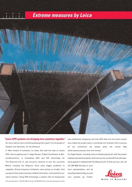
Extreme measures by Leica<br />
“Leica GPS systems are bringing two countries together.”<br />
A 16km stretch of turbulent, icy water. But with the help of Leica’s<br />
GPS, they’re getting over it. Aage Hansen, Project Coordinator at Øre-<br />
sundkonsortium, is overseeing GEO and GIS technology for<br />
The Øresund Link. A vast structure planned to join the countries.<br />
“ Before crossing the Øresund, there were bigger problems to<br />
negotiate. Strong frequency limitations were giving us trouble. And<br />
a project of this scale must have reliable information. Leica had the inno-<br />
vative solution. Using GPS technology, a system with six frequencies<br />
Call Leica Geosystems +1 800 367 9453 (Americas) +65 568 9845 (Asia) or www.leica-geosystems.com/ads<br />
was established. Supplying real time GPS data over the entire project<br />
area makes the project easy to coordinate and maintain And it ensures.<br />
all our contractors are always given the correct data ,<br />
which saves everyone time and money.”<br />
For Aage Hansen, choosing Leica is already paying off, with the project<br />
making impressive progress. And now you too can benefit from the expe-<br />
rience gained in helping build The Øresund Link. To find out how, call +44<br />
181 256 9030 (Europe) or your<br />
local representative, and let<br />
Leica Geosystems help you and<br />
your projects go further.<br />
M A D E T O M E A S U R E