


Create successful ePaper yourself
Turn your PDF publications into a flip-book with our unique Google optimized e-Paper software.
Porkkala, Finland<br />
be reached by arti llery from the base, which was also referred to<br />
as a pistol against Finland’s head.<br />
The Soviet army left the area 12 years later. The period is also<br />
known as the Porkkala Parenthesis.<br />
A military strategic location on the Gulf of Finland<br />
The main objecti ve of the occupati on of Porkkala was to block<br />
the Gulf of Finland at its narrowest point between Finland and<br />
Estonia, a distance of only 36 kilometers. There were naval bases<br />
and strong arti llery on both sides. A fort was also located south<br />
of Porkkala on the island Makilo (not accessible today).<br />
The plan to secure the Gulf of Finland and the entrance to<br />
Leningrad was an old one. Such a plan had already been decided<br />
following the Russian-Japanese <strong>war</strong> in 1905.<br />
The evacuation of Porkkala’s inhabitants in 1944<br />
The area of Porkkala covers 42.5 square kilometers of land. It<br />
was shocking for the 7,000 residents to be given just nine days<br />
to leave, along with all their belongings and 8,000 animals,<br />
the potato and wheat crop and as much hay for the winter<br />
as possible. 20,000 people assisted the inhabitants with the<br />
evacuati on.<br />
At least 30,000 people from the Soviet Union moved into the<br />
area during the period of the lease, including 10,000 civilians.<br />
Soviet society in Porkkala was totally cut off from the rest of<br />
Finnish society.<br />
Handed back to Finland in 1956<br />
By 1955, the military importance of Porkkala had lessened<br />
due to new weapons and a new, strong center for the Soviet<br />
Navy in Kaliningrad. Furthermore, bilateral relati ons between<br />
Finland and the Soviet Union were now improved. Porkkala<br />
was therefore handed back to Finland in 1956. Most of the<br />
former inhabitants returned to their old homes, but also to the<br />
reconstructi on of a completely dilapidated area.<br />
<br />
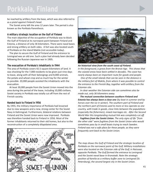
An historical view from the south coast of Finland.<br />
In the foreground, a grave from the Bronze Age. This shows that<br />
the coastal areas have been sett led in decades. The coast has<br />
nearly always been an important route for goods and people.<br />
One of the small islands that can be seen in the distance is<br />
the military fort of Makilo, from where it was possible to control<br />
the entrance to the Finnish Bay, together with arti llery from the<br />
Estonian site.<br />
In clear weather the Estonian side can someti mes also be<br />
made out, only 36 kilometers away.<br />
The mutual connecti on between southern Finland and<br />
Estonia has always been a close one (by boat in summer and by<br />
horses over the ice in winter). The southern part of Finland and<br />
the northern part of Estonia used to more or less operate as one<br />
country, with trade in goods, close links between the populati ons<br />
(especially the fi shermen), mixed marriages etc. Aft er the Second<br />
World War this longstanding mutual link was completely cut off .<br />
Fugiti ves from the Soviet Union. The only signs of life “from<br />
the other side” were fugiti ves from the Soviet Union who would<br />
someti mes pass by in small boats trying to reach Sweden.<br />
Finland was not a safe place for these people, as they were<br />
frequently sent back to the Soviet Union.<br />
The map shows the Gulf of Finland and the strategic locati on of<br />
Porkkala on the narrowest point of the Gulf. Military installati ons<br />
were also located on the Estonian side of the Gulf, in Naissaar,<br />
opposite Porkkala. The Gulf formed the entrance to Leningrad<br />
and the Soviet naval base in Kronstadt. Note the strategic<br />
positi on of Karelia as a military buff er zone to Leningrad (St.<br />
Petersburg), the second largest city in the Soviet Union.<br />
41