Cruel Summer? - National Weather Service Southern Region ...
Cruel Summer? - National Weather Service Southern Region ...
Cruel Summer? - National Weather Service Southern Region ...

You also want an ePaper? Increase the reach of your titles
YUMPU automatically turns print PDFs into web optimized ePapers that Google loves.
Blame it on NAO: Negative Phase the New <strong>Summer</strong> Normal?<br />
Past articles have described the puzzle pieces that define a summer season for the Rio Grande Valley. Many look to<br />
El Niño/<strong>Southern</strong> Oscillation (ENSO) to improve seasonal predictability, particularly in winter (rainy vs. dry, warm vs.<br />
cool) and summer (more tropical cyclones vs. fewer). The reality of impact goes well beyond ENSO in any summer<br />
but perhaps more this year, as the ENSO phase is squarely forecast to remain neutral. Neutral phase ENSO adds<br />
little information to the forecast season, other than not to impact the effectiveness of the very warm waters in the<br />
Main Development <strong>Region</strong>.<br />
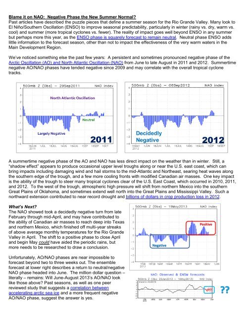
We’ve noticed something else the past few years: A persistent and sometimes pronounced negative phase of the<br />
Arctic Oscillation (AO) and North Atlantic Oscillation (NAO) from June to late August in 2011 and 2012. <strong>Summer</strong>time<br />
negative AO/NAO phases have tended negative since 2009 and may correlate with the overall tropical cyclone<br />
tracks.<br />
A summertime negative phase of the AO and NAO has less direct impact on the weather than in winter. Still, a<br />
“shadow effect” appears to produce occasional upper level troughs along or near the U.S. east coast, which can<br />
bring impacts including damaging wind and hail storms to the mid-Atlantic and Northeast, searing heat waves along<br />
the southern edge of the trough, and a few more cooling fronts with modified Canadian air masses. One key impact<br />
is the ability of the trough to steer many tropical cyclones clear of the U.S. East Coast, which occurred in 2010, 2011,<br />
and 2012. To the west of the trough, atmospheric high pressure will shift from northern Mexico into the southern<br />
Great Plains of Oklahoma, and sometimes extend well north into the Great Plains and Mississippi Valley. Such a<br />
northward extension contributed to near record drought and billions of dollars in crop production loss in 2012.<br />
What’s Next?<br />
The NAO showed took a decidedly negative turn from late<br />
February through mid-April, and may have contributed to<br />
the ability of Canadian air masses to reach deep into Texas<br />
and northern Mexico, which finished off multi-year streaks<br />
of above average monthly temperatures for the Rio Grande<br />
Valley in April. The shift to a positive phase to close April<br />
and begin May could have aided the periodic rains, but<br />
more needs to be researched to draw a conclusion.<br />
Unfortunately, AO/NAO phases are near impossible to<br />
forecast beyond two to three weeks out. The ensemble<br />
forecast at lower right describes a return to neutral/negative<br />
NAO phase headed into June. The million dollar question –<br />
literally – remains: Will June-August 2013’s AO/NAO look<br />
like those above? Past seasons, as well as one peer<br />
reviewed study that suggests a correlation between<br />
accelerating arctic sea ice and a more frequent negative<br />
AO/NAO phase, suggest the answer is yes.