Welcome to the summer edition of the CoCoRaHS newsletter ...
Welcome to the summer edition of the CoCoRaHS newsletter ...
Welcome to the summer edition of the CoCoRaHS newsletter ...

You also want an ePaper? Increase the reach of your titles
YUMPU automatically turns print PDFs into web optimized ePapers that Google loves.
<strong>Welcome</strong> <strong>to</strong> <strong>the</strong> <strong>summer</strong> <strong>edition</strong> <strong>of</strong> <strong>the</strong><br />
<strong>CoCoRaHS</strong> <strong>newsletter</strong>! by Christina Barron<br />
We’ve definitely had some noticeable<br />
changes over <strong>the</strong> past several months<br />
— going from bone dry wea<strong>the</strong>r in <strong>the</strong><br />
fall <strong>of</strong> 2011 <strong>to</strong> strong <strong>to</strong> severe thunders<strong>to</strong>rms,<br />
flooding and some improvements<br />
in <strong>the</strong> drought status in <strong>the</strong><br />
spring <strong>of</strong> 2012. We’ve also experienced<br />
late season cold frontal passages and<br />
abnormally high temperatures. Typical<br />
Texas wea<strong>the</strong>r, eh?<br />
With <strong>the</strong> exiting La Niña season, more<br />
changes are in s<strong>to</strong>re for <strong>the</strong> <strong>summer</strong><br />
in<strong>to</strong> fall seasons. In this article, we’ll<br />
explore what changes are typical with<br />
<strong>the</strong> entering ENSO (El Niño – Sou<strong>the</strong>rn<br />
The South Texas Regional<br />
<strong>CoCoRaHS</strong> Newsletter<br />
Climate Prediction Outlook:<br />
Normal Rainfall Possible?<br />
Drought Improvement? By Juan Alanis & Christina Barron<br />
While some areas <strong>of</strong> South Texas and <strong>the</strong><br />
coastal bend have been receiving plentiful<br />
rainfall, many o<strong>the</strong>rs have not. There is finally<br />
some good news in terms <strong>of</strong> rainfall — outlooks<br />
are calling for a return <strong>of</strong> near normal<br />
rainfall patterns over <strong>the</strong> <strong>summer</strong> and fall.<br />
The 3-Month outlook for June/July/ August<br />
shows an equal chance for above, below or near<br />
normal rainfall for most <strong>of</strong> <strong>the</strong> contiguous U.S.<br />
Oscillation)/ Neutral season from rainfall <strong>to</strong><br />
hurricanes <strong>to</strong> <strong>the</strong> current drought status.<br />
Rainfall amounts as depicted from <strong>the</strong> Advanced<br />
Hydrologic Prediction Service (AHPS) for <strong>the</strong><br />
period <strong>of</strong> Jan—May 2012. Localized rainfall<br />
amounts range from a trace <strong>to</strong> 25+ inches.<br />
E xi ti ng La Ni ña Pa tter n<br />
According <strong>to</strong> <strong>the</strong> Climate Prediction Center<br />
(CPC), <strong>the</strong> La Niña pattern that has<br />
devastated much <strong>of</strong> <strong>the</strong> state since late<br />
2010, has <strong>of</strong>ficially ended.<br />
During a La Niña year, drier and warmer<br />
than normal conditions are experienced.<br />
With <strong>the</strong> exit <strong>of</strong> La Niña and an entering<br />
ENSO (El Niño-Sou<strong>the</strong>rn Oscillation)/<br />
Neutral season, rainfall is clima<strong>to</strong>logically<br />
expected <strong>to</strong> increase with near normal<br />
rainfall possible.<br />
Observations <strong>of</strong> cooler sea surface temperatures<br />
in <strong>the</strong> eastern equa<strong>to</strong>rial Pacific<br />
waters can provide evidence <strong>to</strong><br />
whe<strong>the</strong>r or not a La Niña is occurring or<br />
showing trends <strong>of</strong> occurring.<br />
(continued on page 2)<br />
NWS<br />
Corpus<br />
Christi<br />
Summer 2012<br />
Edition<br />
Inside this issue:<br />
<strong>Welcome</strong> Message 1<br />
Climate Prediction<br />
Outlook<br />
2012 Hurricane<br />
Season<br />
South Texas<br />
Severe Wea<strong>the</strong>r Recap<br />
SKYWARN Classes<br />
<strong>Welcome</strong> New<br />
Observers!<br />
Observers Wanted:<br />
Measure<br />
Evapotranspiration<br />
1-2<br />
3<br />
3-4<br />
5<br />
5<br />
6<br />
<strong>CoCoRaHS</strong> Webinar 6<br />
National Wea<strong>the</strong>r Service<br />
Mission Statement<br />
and Brief His<strong>to</strong>ry<br />
<strong>CoCoRaHS</strong> Tips 7<br />
7
Page 2 The South Texas Regional <strong>CoCoRaHS</strong> Newsletter<br />
I mpac tin g <strong>the</strong> Dr ou gh t<br />
During <strong>the</strong> Spring <strong>of</strong> 2012, <strong>the</strong> La Niña wea<strong>the</strong>r pattern weakened<br />
which allowed for more generous rains <strong>to</strong> parts <strong>of</strong> North,<br />
Central and South Texas as frontal boundaries and upper level<br />
disturbances approached <strong>the</strong> area. Due <strong>to</strong> <strong>the</strong> abundant rainfall,<br />
<strong>the</strong>re has been improvement <strong>to</strong> <strong>the</strong> drought status over<br />
South Texas. As <strong>of</strong> April 2012, <strong>the</strong> status <strong>of</strong> Exceptional<br />
Drought has been removed from South Texas—however, Moderate<br />
<strong>to</strong> Severe <strong>to</strong> Extreme drought conditions continue <strong>to</strong> exist<br />
over portions <strong>of</strong> <strong>the</strong> area. Any additional (or lack <strong>the</strong>re<strong>of</strong>) will<br />
lead <strong>to</strong> improving (or deteriorating) conditions.<br />
C li ma te Pre dic ti on Center Ou tl ook<br />
As we enter <strong>the</strong> dog days <strong>of</strong> <strong>summer</strong> across South Texas, <strong>the</strong><br />
CPC expects ENSO/Neutral conditions <strong>to</strong> prevail in <strong>the</strong> tropical<br />
Pacific waters. For South Texas, this will mean areas may receive<br />
more frequent rains from daily sea breezes—a feature<br />
which La Nina prevents.<br />
Far<strong>the</strong>r down <strong>the</strong> line, some <strong>of</strong> <strong>the</strong> CPC forecast models show<br />
an El Niño pattern developing. This means <strong>the</strong> waters <strong>of</strong> <strong>the</strong><br />
tropical Pacific become warmer than normal. An El Niño pattern,<br />
if it develops, clima<strong>to</strong>logically leads <strong>to</strong> a wetter than normal<br />
fall and winter seasons across sou<strong>the</strong>rn Texas….which<br />
would be great news.<br />
The latest 3-Month Outlooks from <strong>the</strong> CPC show equal chances<br />
for Above, Below or near Normal rainfall through August. This<br />
means that normal rainfall is possible, but due <strong>to</strong> <strong>the</strong> transition<br />
period from a La Niña <strong>to</strong> an ENSO/Neutral Season, above or<br />
below normal rainfall remains possible as well. A good point <strong>to</strong><br />
take is that CPC does not see a more favorable chance for below<br />
normal rainfall. However, a downside <strong>to</strong> <strong>the</strong> outlooks is <strong>the</strong><br />
forecast for above normal temperatures through August.<br />
BELOW: Warming temperatures over <strong>the</strong> eastern Pacific is a transitioning sign <strong>of</strong> an exiting La Niña wea<strong>the</strong>r pattern in<strong>to</strong><br />
an ENSO (El Niño-Sou<strong>the</strong>rn Oscillation)/Neutral wea<strong>the</strong>r pattern. The pictures below were taken 7 months apart.<br />
The 7-day Average Sea Surface Temperatures across<br />
<strong>the</strong> equa<strong>to</strong>rial Pacific waters centering on<br />
May 16, 2012<br />
ABOVE: The U.S. Drought moni<strong>to</strong>r showing Abnormally<br />
Dry <strong>to</strong> Extreme Drought over South Texas.<br />
BELOW: There is a greater chance for Above Normal<br />
Temperatures for <strong>the</strong> 3-Month period <strong>of</strong><br />
June/July/August.<br />
The 7-day Average Sea Surface Temperatures across<br />
<strong>the</strong> equa<strong>to</strong>rial Pacific waters centering on<br />
Oc<strong>to</strong>ber 19, 2011
Page 3 The South Texas Regional <strong>CoCoRaHS</strong> Newsletter<br />
2012 Hurricane Season by Christina Barron<br />
June 1, 2012 marks <strong>the</strong> <strong>of</strong>ficial first day <strong>of</strong> <strong>the</strong> 6 month long<br />
2012 Atlantic hurricane season! NOAA announced that atmospheric<br />
and oceanic conditions will favor a near-normal hurricane<br />
season as we exit <strong>the</strong> La Niña season and enter <strong>the</strong> EN-<br />
SO/Neutral season.<br />
Hurricane Forecast<br />
� 9 – 15 named s<strong>to</strong>rms (with winds <strong>of</strong> 39 mph or greater)<br />
� 4 – 8 <strong>of</strong> <strong>the</strong> named s<strong>to</strong>rms becoming hurricanes (winds<br />
<strong>of</strong> 74 mph or greater)<br />
� 1 – 3 <strong>of</strong> those hurricanes becoming major hurricanes<br />
(winds <strong>of</strong> 111 mph or greater).<br />
If <strong>the</strong> development <strong>of</strong> an El Niño occurs by late <strong>summer</strong>, <strong>the</strong><br />
numbers may decrease, which is typical in an El Niño pattern,<br />
although, not always true.<br />
No matter what <strong>the</strong> chances are, everyone should always prepare<br />
as if this is <strong>the</strong> year a hurricane will hit <strong>the</strong> middle Texas<br />
coast.<br />
For more information on any approaching tropical cyclones,<br />
check out <strong>the</strong> following websites:<br />
National Hurricane Center: www.nhc.noaa.gov<br />
NWS Corpus Christi: www.wea<strong>the</strong>r.gov/corpuschristi<br />
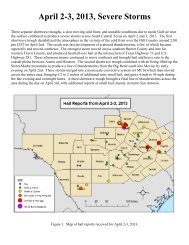
South Texas Severe Wea<strong>the</strong>r Recap by Christina Barron<br />
When forecasting for <strong>the</strong> area, meteorologist look for<br />
three main wea<strong>the</strong>r ingredients: moisture, instability and<br />
a type <strong>of</strong> lifting mechanism. Being near <strong>the</strong> Gulf <strong>of</strong> Mexico,<br />
bountiful moisture and instability is usual over South<br />
Texas. However, due <strong>to</strong> <strong>the</strong> proximity <strong>of</strong> <strong>the</strong> Sierra Madre<br />
located in Mexico, dry air frequently moves in over <strong>the</strong><br />
South Texas region, “capping” or limiting s<strong>to</strong>rm production.<br />
This is when a lifting mechanism in <strong>the</strong> form <strong>of</strong> an<br />
upper disturbance or frontal boundary aides in overcoming<br />
<strong>the</strong> “cap”.<br />
During <strong>the</strong> first few months <strong>of</strong> 2012, <strong>the</strong>re have already<br />
been multiple occasions where severe wea<strong>the</strong>r has occurred<br />
across South Texas bringing large hail, heavy rain,<br />
flooding and <strong>to</strong>rnados due <strong>to</strong> all <strong>of</strong> <strong>the</strong> three wea<strong>the</strong>r ingredients<br />
coming <strong>to</strong>ge<strong>the</strong>r and <strong>the</strong> “cap” being very weak<br />
or non-existent. The <strong>to</strong>rnados confirmed during <strong>the</strong> period<br />
were rated using <strong>the</strong> Enhanced Fujita – with ratings <strong>of</strong><br />
ei<strong>the</strong>r EF-0 (65 - 85 mph) or EF-1 (86 – 110 mph).<br />
Squall Line through South Texas, March 19/20<br />
In <strong>the</strong> late evening <strong>of</strong> March 19th, a squall line (a strong<br />
line <strong>of</strong> thunders<strong>to</strong>rms) moved through <strong>the</strong> South Texas.<br />
This long line <strong>of</strong> strong <strong>to</strong> severe thunders<strong>to</strong>rms brought<br />
strong winds <strong>to</strong> <strong>the</strong> area – with winds <strong>of</strong> 60 – 80 mph<br />
along <strong>the</strong> main line and winds <strong>of</strong> 40 – 50 mph reported<br />
behind <strong>the</strong> squall line. The strong winds caused damages<br />
<strong>to</strong> <strong>the</strong> George West area where ro<strong>of</strong>s and bay doors were<br />
blown down, as well as large tree limbs, utility poles,<br />
signs and fence posts. Rainfall amounts averaged 1-2<br />
inches.<br />
(continued on page 4)
The South Texas Regional <strong>CoCoRaHS</strong> Newsletter<br />
Strong winds in Port Lavaca, April 2<br />
Page 4<br />
Late on April 1st in<strong>to</strong> <strong>the</strong> early morning hours <strong>of</strong> April 2 nd , an upper disturbance aided in <strong>the</strong> development <strong>of</strong> strong<br />
thunders<strong>to</strong>rms that started over west Texas near Del Rio, that moved southward across <strong>the</strong> Brush country showing<br />
some weakening trends. However, as <strong>the</strong> s<strong>to</strong>rms reached <strong>the</strong> more unstable atmosphere near <strong>the</strong> coastal area, <strong>the</strong><br />
s<strong>to</strong>rms streng<strong>the</strong>ned bringing strong winds <strong>to</strong> areas along <strong>the</strong> nor<strong>the</strong>rn Coastal Bend – particularly over Port Lavaca.<br />
Estimated winds in excess <strong>of</strong> 70 mph were experienced in Port Lavaca which caused trees <strong>to</strong> be uprooted and large<br />
tree limbs <strong>to</strong> be scattered around in addition <strong>to</strong> ro<strong>of</strong> damages and telephone poles being snapped. Elsewhere across<br />
South Texas, winds <strong>of</strong> 45-55 mph with higher gusts were being reported.<br />
Heavy Rain/Flooding/Tornados, April 15/16<br />
LEFT:<br />
A large tree<br />
snapped in<br />
George West<br />
during <strong>the</strong><br />
March 19/20<br />
event.<br />
The combination <strong>of</strong> a stalled surface frontal boundary and<br />
an upper level disturbance became <strong>the</strong> focus for <strong>the</strong> heavy<br />
rain event that occurred April 15 th /16 th . In addition <strong>to</strong> <strong>the</strong><br />
heavy rain, s<strong>to</strong>rms streng<strong>the</strong>ned <strong>to</strong> produce large hail up <strong>to</strong><br />
1.75” in diameter reported in Goliad, along with 4 confirmed<br />
<strong>to</strong>rnados that developed over <strong>the</strong> sou<strong>the</strong>rn coastal bend – 3<br />
<strong>of</strong> <strong>the</strong> <strong>to</strong>rnados near <strong>the</strong> Portland/Gregory area. On <strong>the</strong><br />
16 th , s<strong>to</strong>rms developed over <strong>the</strong> same locations throughout<br />
<strong>the</strong> day leading <strong>to</strong> general rainfall amounts <strong>of</strong> 2 <strong>to</strong> 6 inches<br />
– with isolated amounts up <strong>to</strong> 15 inches near Bayside. This<br />
type <strong>of</strong> constant, heavy rainfall led <strong>to</strong> multiple reports <strong>of</strong><br />
flooding in eastern San Patricio, Nueces and Refugio counties.<br />
For a more detailed report on <strong>the</strong>se s<strong>to</strong>rms, check out<br />
<strong>the</strong> NWS Corpus Christi homepage: www.wea<strong>the</strong>r.gov/<br />
corpuschristi<br />
Under Additional Info—Major Events<br />
LEFT:<br />
Tornado<br />
damage <strong>to</strong> a<br />
grain eleva<strong>to</strong>r<br />
west <strong>of</strong> Taft<br />
on May 10.<br />
Tornados/Large Hail, May 10<br />
LEFT:<br />
A large tree<br />
uprooted in<br />
Port Lavaca<br />
during <strong>the</strong><br />
April 2nd<br />
event.<br />
ABOVE: The 2-day Rainfall amount for April<br />
15/16. Areas in San Patricio County received <strong>the</strong><br />
bulk <strong>of</strong> <strong>the</strong> heavy rainfall.<br />
A second <strong>to</strong>rnado outbreak occurred on May 10 th due <strong>to</strong> an<br />
approaching upper level disturbance that started <strong>the</strong> thunders<strong>to</strong>rm<br />
development early in <strong>the</strong> morning over areas<br />
across Brush Country, increasing in coverage far<strong>the</strong>r east<br />
through <strong>the</strong> day, with a squall line finally developing late<br />
that night. Strong winds developed within <strong>the</strong> strong s<strong>to</strong>rms<br />
– especially late within <strong>the</strong> squall line. S<strong>to</strong>rm surveys confirmed<br />
<strong>the</strong> development <strong>of</strong> 5 <strong>to</strong>rnados – with 4 <strong>of</strong> <strong>the</strong> <strong>to</strong>rnados<br />
over <strong>the</strong> coastal bend and one <strong>to</strong>rnado northwest <strong>of</strong><br />
Cotulla. The severe s<strong>to</strong>rms also produced large hail ranging<br />
from 1.00” across all <strong>of</strong> South Texas, with hail <strong>of</strong> 2.75” in<br />
diameter reported southwest <strong>of</strong> George West <strong>to</strong> 4.25” diameter<br />
hail reported sou<strong>the</strong>ast <strong>of</strong> Encinal.
Page 5 The South Texas Regional <strong>CoCoRaHS</strong> Newsletter<br />
<strong>Welcome</strong> New Observers! by Juan Alanis<br />
The National Wea<strong>the</strong>r Service in Corpus Christi would like <strong>to</strong> extend a big<br />
warm welcome <strong>to</strong> all new <strong>CoCoRaHS</strong> observers! We are looking forward<br />
<strong>to</strong> everyone’s rainfall data, as it greatly helps verify radar rainfall estimates<br />
and moni<strong>to</strong>r regional rainfall patterns over time.<br />
More observers are needed throughout South Texas and <strong>the</strong> coastal bend<br />
region. Observers are especially needed <strong>the</strong> following areas:<br />
McMullen County, sou<strong>the</strong>rn Goliad County and nor<strong>the</strong>rn half <strong>of</strong><br />
Refugio County.<br />
To become part <strong>of</strong> <strong>the</strong> <strong>CoCoRaHS</strong> observer network, all that is needed is<br />
a high interest in <strong>the</strong> wea<strong>the</strong>r and be willing <strong>to</strong> report rainfall <strong>to</strong>tals daily.<br />
To join <strong>CoCoRaHS</strong>, log on<strong>to</strong> www.cocorahs.org and click on “Join CoCo-<br />
RaHS”. For more information, call Christina Barron at 361-289-0959 or<br />
Juan Alanis, Jr. at 956-251-3996.<br />
NEW OBSERVERS<br />
SKYWARN Classes by Christina Barron<br />
What is SkyWarn? SkyWarn is a volunteer program comprised <strong>of</strong> nearly<br />
290,000 trained severe wea<strong>the</strong>r spotters. SkyWarn spotters provide timely<br />
and accurate reports <strong>of</strong> severe wea<strong>the</strong>r <strong>to</strong> <strong>the</strong>ir local National Wea<strong>the</strong>r<br />
Service <strong>of</strong>fice. You’ll learn what <strong>to</strong> look for when observing severe wea<strong>the</strong>r,<br />
as well as understand <strong>the</strong> development <strong>of</strong> severe thunders<strong>to</strong>rms, <strong>to</strong>rnadoes<br />
How do I get involved?<br />
and flash flooding.<br />
Your local National Wea<strong>the</strong>r Service Office in Corpus Christi is extending an invitation for all <strong>of</strong> those interested in taking<br />
part in FREE SkyWarn training course. Courses are held during <strong>the</strong> late winter/early spring months before <strong>the</strong><br />
peak <strong>of</strong> severe wea<strong>the</strong>r season.<br />
NEW ONLINE Skywarn Training Course<br />
Busy schedule? Take <strong>the</strong> new online courses <strong>to</strong> cover <strong>the</strong> basics <strong>of</strong> becoming a S<strong>to</strong>rm Spotter. Click on <strong>the</strong> link <strong>to</strong> <strong>the</strong><br />
main website (linked below), review <strong>the</strong> courses and email your certificate <strong>to</strong> John Metz (linked below). It’s that easy!<br />
Check out <strong>the</strong> following link for upcoming courses in your area: http://www.srh.noaa.gov/crp/?n=skywarn<br />
If <strong>the</strong>re are currently no classes being <strong>of</strong>fered in your area and you would like <strong>to</strong> see what SkyWarn is all about,<br />
please email Jason Runyen (Jason.Runyen@noaa.gov) or John Metz (John.Metz@noaa.gov) and we can try <strong>to</strong> organize<br />
a course for your community.<br />
TX-AR-8 Aransas Pass 6.1 NNW<br />
TX-AR-9 Rockport 2.3 NNE<br />
TX-BEE-16 Kenedy 13.5 SW<br />
TX-BEE-17 Normana 0.5 ENE<br />
TX-CLH 11 Port Lavaca 1.9 SW<br />
TX-GD-23 Goliad 10.3 NE<br />
TX-GD-24 Berclair 7.3 NW<br />
TX-JW-8 Pali<strong>to</strong> Blanco 1.0 ESE<br />
TX-LS-9 Cotulla 9.7 NNE<br />
TX-LO-16 George West 11.3 S<br />
TX-LO-17 Mathis 11.6 NW<br />
TX-NU-49 Port Aransas 1.5 ENE<br />
TX-NU-50 Robs<strong>to</strong>wn 14.5 WNW<br />
TX-RF-9 Woodsboro 0.3 W<br />
TX-SP-14 Odem 0.5 W<br />
TX-SP-15 Mathis 7.5 SSE<br />
TX-SP-16 Aransas Pass 2.9 WNW<br />
TX-SP-17 Portland 2.4 NE<br />
TX-VCT-24 Inez 1.8 WNW<br />
TX-VCT-25 Vic<strong>to</strong>ria 9.5 WSW<br />
TX-VCT-26 Vic<strong>to</strong>ria 3.8 NW<br />
TX-WB-41 Laredo 8.4 NNW<br />
TX-WB-42 Laredo 4.9 NNE<br />
TX-WB-43 El Cenizo 0.2 W
The South Texas Regional <strong>CoCoRaHS</strong> Newsletter<br />
Page 6<br />
Observers Wanted for Measuring<br />
Evapotranspiration by Juan Alanis<br />
The <strong>of</strong>ficial gauge for taking<br />
evapotranspiration observations.<br />
As <strong>CoCoRaHS</strong> continues <strong>to</strong> grow and expand across <strong>the</strong> nation and Canada, so do<br />
<strong>the</strong> opportunities for people <strong>to</strong> help ga<strong>the</strong>r valuable wea<strong>the</strong>r information.<br />
<strong>CoCoRaHS</strong> is now calling for very dedicated observers, those that have reported<br />
daily for a consistent amount <strong>of</strong> time, <strong>to</strong> help measure “evapotranspiration” or ET.<br />
ET is <strong>the</strong> water evaporated from <strong>the</strong> ground back <strong>to</strong> <strong>the</strong> atmosphere both as transpiration<br />
from <strong>the</strong> leaves <strong>of</strong> plants and also as direct evaporation from open water<br />
and soil.<br />
Knowing <strong>the</strong> amount <strong>of</strong> water leaving <strong>the</strong> soil and returning <strong>to</strong> <strong>the</strong> atmosphere is<br />
just as important as <strong>the</strong> amount that falls as rain. It matters for agriculture, lawn<br />
care, wea<strong>the</strong>r prediction, hydrology and much more, so we should try <strong>to</strong> measure<br />
it.<br />
Those interested should log on<strong>to</strong> www.cocorahs.org or contact Zach at:<br />
info@cocorahs.org for more information. Those interested should keep in mind that<br />
measuring ET is for <strong>the</strong> truly dedicated only, as an <strong>of</strong>ficial ET gauge will cost $212<br />
plus tax and shipping.<br />
<strong>CoCoRaHS</strong> Webinars by Juan Alanis<br />
Would you like <strong>to</strong> learn about <strong>the</strong> wea<strong>the</strong>r from <strong>the</strong> experts<br />
and talk <strong>to</strong> <strong>the</strong>m? <strong>CoCoRaHS</strong> has started a new series<br />
about <strong>the</strong> wea<strong>the</strong>r titled “<strong>CoCoRaHS</strong> Wea<strong>the</strong>r Talk”.<br />
The series consists <strong>of</strong> monthly web seminars (webinars)<br />
featuring engaging experts for <strong>the</strong> world <strong>of</strong> meteorology,<br />
clima<strong>to</strong>logy and related fields. These webinars are about<br />
60 minutes in length and allow audience members <strong>to</strong> ask<br />
questions <strong>to</strong> <strong>the</strong> experts.<br />
Webinar <strong>to</strong>pics include climate change, hurricanes, air pollution,<br />
radar meteorology among many o<strong>the</strong>rs. These Co-<br />
CoRaHS Wea<strong>the</strong>r Talk webinars are free <strong>to</strong> everyone, all<br />
you need <strong>to</strong> do is register through <strong>the</strong> <strong>CoCoRaHS</strong> web site<br />
<strong>to</strong> participate.<br />
Upcoming <strong>CoCoRaHS</strong> Webinar Schedule:<br />
Thursday June 14, , 2012, 6PM CDT<br />
Hurricane Analysis and Prediction at <strong>the</strong> National<br />
Hurricane Center<br />
Chris Landsea, NOAA/NWS/National Hurricane Center<br />
Miami, FL<br />
Thursday July 19, 2012, 12PM CDT<br />
Wind and Wildfire, A Dangerous Combination<br />
Liz Page, UCAR/COMET<br />
Boulder, Colorado<br />
Thursday August 23, 2012 12PM CDT<br />
Extreme Rainfall, How We Analyze It<br />
and How <strong>the</strong> Data is Used<br />
Bill Kappel, Applied Wea<strong>the</strong>r Associates<br />
Monument, Colorado<br />
September 2012, date <strong>to</strong> be announced<br />
So You want <strong>to</strong> be a meteorologist?<br />
Dave Changnon, Nor<strong>the</strong>rn Illinois University<br />
Future webinar <strong>to</strong>pics and dates will be announced in<br />
future issues <strong>of</strong> <strong>the</strong> South Texas <strong>CoCoRaHS</strong> <strong>newsletter</strong>.
Page 7 The South Texas Regional <strong>CoCoRaHS</strong> Newsletter<br />
National Wea<strong>the</strong>r Service<br />
426 Pinson Drive<br />
Corpus Christi, TX 78406<br />
Public Phone Line: (361) 289-0959 ext.1<br />
Recorded Forecasts: (361) 289-1861<br />
E-mail: christina.barron@noaa.gov<br />
National Wea<strong>the</strong>r Service Mission Statement:<br />
The National Wea<strong>the</strong>r Service (NWS) provides wea<strong>the</strong>r, hydrologic,<br />
and climate forecasts and warnings for <strong>the</strong> United States, its<br />
terri<strong>to</strong>ries, adjacent waters and ocean areas, for <strong>the</strong> protection <strong>of</strong><br />
life and property and <strong>the</strong> enhancement <strong>of</strong> <strong>the</strong> national economy.<br />
NWS data and products form a national information database and<br />
infrastructure which can be used by o<strong>the</strong>r governmental agencies,<br />
<strong>the</strong> private sec<strong>to</strong>r, <strong>the</strong> public, and <strong>the</strong> global community.<br />
Brief National Wea<strong>the</strong>r Service His<strong>to</strong>ry:<br />
The National Wea<strong>the</strong>r Service has its beginnings in <strong>the</strong> early his<strong>to</strong>ry<br />
<strong>of</strong> <strong>the</strong> United States. Wea<strong>the</strong>r has always been important <strong>to</strong> <strong>the</strong><br />
citizenry <strong>of</strong> this country, and this was especially true during <strong>the</strong><br />
17th and 18th centuries.<br />
The beginning <strong>of</strong> <strong>the</strong> National Wea<strong>the</strong>r Service we know <strong>to</strong>day<br />
started on February 9th, 1870, when President Ulysses S. Grant<br />
signed a joint resolution <strong>of</strong> Congress authorizing <strong>the</strong> Secretary <strong>of</strong><br />
War <strong>to</strong> establish a national wea<strong>the</strong>r service.<br />
ON THE WEB!<br />
http://www.wea<strong>the</strong>r.gov/corpuschristi<br />
<strong>CoCoRaHS</strong> Tips by Christina Barron<br />
Going on vacation for a couple <strong>of</strong> days and it rains?...<br />
...use “Multi-Day Accumulation” for your rainfall report when you<br />
come back. When you’re out and it rains, your rainfall report is still important<br />
<strong>to</strong> <strong>the</strong> NWS. By not knowing <strong>the</strong> exact day <strong>of</strong> when it rained, <strong>the</strong><br />
multi-day accumulation report comes in handy!<br />
Significant wea<strong>the</strong>r?...<br />
…use <strong>the</strong> “Significant wea<strong>the</strong>r” or “Hail” link under <strong>the</strong> “Enter New<br />
Reports” section. During severe wea<strong>the</strong>r events, things such as excessive<br />
rainfall, hail, flash flooding, wind damage, and, yes, even in South Texas,<br />
snowfall, are well appreciated in real-time. When you use one <strong>of</strong> <strong>the</strong><br />
mentioned links above, it alarms <strong>the</strong> computers at <strong>the</strong> NWS <strong>to</strong> let us<br />
know that you have just witnessed significant wea<strong>the</strong>r.<br />
Now remember, if wea<strong>the</strong>r conditions outside are <strong>to</strong>o dangerous for you<br />
<strong>to</strong> take measurements, please, wait out <strong>the</strong> s<strong>to</strong>rm and do not go outside.<br />
Your safety means more <strong>to</strong> us.<br />
Dirty rain gauge?...<br />
...using some dish soap and a bottle brush can do <strong>the</strong> trick!<br />
Wea<strong>the</strong>r Q&A<br />
Do you have any questions about<br />
<strong>the</strong> wea<strong>the</strong>r that you would like<br />
answered? Your questions could<br />
lead <strong>to</strong> articles in <strong>the</strong> next issuance<br />
<strong>of</strong> <strong>the</strong> <strong>CoCoRaHS</strong> <strong>newsletter</strong>!<br />
If you do, send an email <strong>to</strong><br />
christina.barron@noaa.gov.<br />
If you would like <strong>to</strong> be featured<br />
in <strong>the</strong> Fall 2012 <strong>edition</strong> <strong>of</strong> <strong>the</strong><br />
S o u t h T e x a s C o C o R a H S<br />
<strong>newsletter</strong>, pl ease emai l<br />
Christi na.Barron@noaa.gov .<br />
We would love <strong>to</strong> hear from<br />
observers <strong>of</strong> SouthTexas!