Welcome to the summer edition of the CoCoRaHS newsletter ...
Welcome to the summer edition of the CoCoRaHS newsletter ...
Welcome to the summer edition of the CoCoRaHS newsletter ...

Create successful ePaper yourself
Turn your PDF publications into a flip-book with our unique Google optimized e-Paper software.
The South Texas Regional <strong>CoCoRaHS</strong> Newsletter<br />
Strong winds in Port Lavaca, April 2<br />
Page 4<br />
Late on April 1st in<strong>to</strong> <strong>the</strong> early morning hours <strong>of</strong> April 2 nd , an upper disturbance aided in <strong>the</strong> development <strong>of</strong> strong<br />
thunders<strong>to</strong>rms that started over west Texas near Del Rio, that moved southward across <strong>the</strong> Brush country showing<br />
some weakening trends. However, as <strong>the</strong> s<strong>to</strong>rms reached <strong>the</strong> more unstable atmosphere near <strong>the</strong> coastal area, <strong>the</strong><br />
s<strong>to</strong>rms streng<strong>the</strong>ned bringing strong winds <strong>to</strong> areas along <strong>the</strong> nor<strong>the</strong>rn Coastal Bend – particularly over Port Lavaca.<br />
Estimated winds in excess <strong>of</strong> 70 mph were experienced in Port Lavaca which caused trees <strong>to</strong> be uprooted and large<br />
tree limbs <strong>to</strong> be scattered around in addition <strong>to</strong> ro<strong>of</strong> damages and telephone poles being snapped. Elsewhere across<br />
South Texas, winds <strong>of</strong> 45-55 mph with higher gusts were being reported.<br />
Heavy Rain/Flooding/Tornados, April 15/16<br />
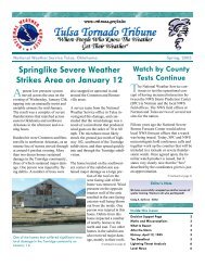
LEFT:<br />
A large tree<br />
snapped in<br />
George West<br />
during <strong>the</strong><br />
March 19/20<br />
event.<br />
The combination <strong>of</strong> a stalled surface frontal boundary and<br />
an upper level disturbance became <strong>the</strong> focus for <strong>the</strong> heavy<br />
rain event that occurred April 15 th /16 th . In addition <strong>to</strong> <strong>the</strong><br />
heavy rain, s<strong>to</strong>rms streng<strong>the</strong>ned <strong>to</strong> produce large hail up <strong>to</strong><br />
1.75” in diameter reported in Goliad, along with 4 confirmed<br />
<strong>to</strong>rnados that developed over <strong>the</strong> sou<strong>the</strong>rn coastal bend – 3<br />
<strong>of</strong> <strong>the</strong> <strong>to</strong>rnados near <strong>the</strong> Portland/Gregory area. On <strong>the</strong><br />
16 th , s<strong>to</strong>rms developed over <strong>the</strong> same locations throughout<br />
<strong>the</strong> day leading <strong>to</strong> general rainfall amounts <strong>of</strong> 2 <strong>to</strong> 6 inches<br />
– with isolated amounts up <strong>to</strong> 15 inches near Bayside. This<br />
type <strong>of</strong> constant, heavy rainfall led <strong>to</strong> multiple reports <strong>of</strong><br />
flooding in eastern San Patricio, Nueces and Refugio counties.<br />
For a more detailed report on <strong>the</strong>se s<strong>to</strong>rms, check out<br />
<strong>the</strong> NWS Corpus Christi homepage: www.wea<strong>the</strong>r.gov/<br />
corpuschristi<br />
Under Additional Info—Major Events<br />
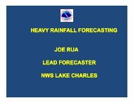
LEFT:<br />
Tornado<br />
damage <strong>to</strong> a<br />
grain eleva<strong>to</strong>r<br />
west <strong>of</strong> Taft<br />
on May 10.<br />
Tornados/Large Hail, May 10<br />
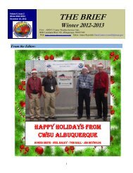
LEFT:<br />
A large tree<br />
uprooted in<br />
Port Lavaca<br />
during <strong>the</strong><br />
April 2nd<br />
event.<br />
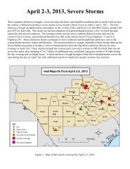
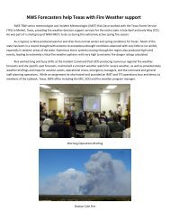
ABOVE: The 2-day Rainfall amount for April<br />
15/16. Areas in San Patricio County received <strong>the</strong><br />
bulk <strong>of</strong> <strong>the</strong> heavy rainfall.<br />
A second <strong>to</strong>rnado outbreak occurred on May 10 th due <strong>to</strong> an<br />
approaching upper level disturbance that started <strong>the</strong> thunders<strong>to</strong>rm<br />
development early in <strong>the</strong> morning over areas<br />
across Brush Country, increasing in coverage far<strong>the</strong>r east<br />
through <strong>the</strong> day, with a squall line finally developing late<br />
that night. Strong winds developed within <strong>the</strong> strong s<strong>to</strong>rms<br />
– especially late within <strong>the</strong> squall line. S<strong>to</strong>rm surveys confirmed<br />
<strong>the</strong> development <strong>of</strong> 5 <strong>to</strong>rnados – with 4 <strong>of</strong> <strong>the</strong> <strong>to</strong>rnados<br />
over <strong>the</strong> coastal bend and one <strong>to</strong>rnado northwest <strong>of</strong><br />
Cotulla. The severe s<strong>to</strong>rms also produced large hail ranging<br />
from 1.00” across all <strong>of</strong> South Texas, with hail <strong>of</strong> 2.75” in<br />
diameter reported southwest <strong>of</strong> George West <strong>to</strong> 4.25” diameter<br />
hail reported sou<strong>the</strong>ast <strong>of</strong> Encinal.