Cruel Summer? - National Weather Service Southern Region ...
Cruel Summer? - National Weather Service Southern Region ...
Cruel Summer? - National Weather Service Southern Region ...

You also want an ePaper? Increase the reach of your titles
YUMPU automatically turns print PDFs into web optimized ePapers that Google loves.
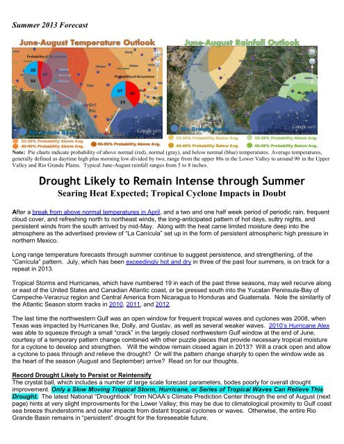
<strong>Summer</strong> 2013 Forecast<br />
Note: Pie charts indicate probability of above normal (red), normal (gray), and below normal (blue) temperatures. Average temperatures,<br />
generally defined as daytime high plus morning low divided by two, range from the upper 80s in the Lower Valley to around 90 in the Upper<br />
Valley and Rio Grande Plains. Typical June-August rainfall ranges from 5 to 8 inches.<br />
Drought Likely to Remain Intense through <strong>Summer</strong><br />
Searing Heat Expected; Tropical Cyclone Impacts in Doubt<br />
After a break from above normal temperatures in April, and a two and one half week period of periodic rain, frequent<br />
cloud cover, and refreshing north to northeast winds, the long-anticipated pattern of hot days, sultry nights, and<br />
persistent winds from the south arrived by mid-May. Along with the heat came limited moisture deep into the<br />
atmosphere as the advertised preview of “La Canícula” set up in the form of persistent atmospheric high pressure in<br />
northern Mexico.<br />
Long range temperature forecasts through summer continue to suggest persistence, and strengthening, of the<br />
“Canícula” pattern. July, which has been exceedingly hot and dry in three of the past four summers, is on track for a<br />
repeat in 2013.<br />
Tropical Storms and Hurricanes, which have numbered 19 in each of the past three seasons, may well recurve along<br />
or east of the United States and Canadian Atlantic coast, or be pressed south into the Yucatan Peninsula-Bay of<br />
Campeche-Veracruz region and Central America from Nicaragua to Honduras and Guatemala. Note the similarity of<br />
the Atlantic Season storm tracks in 2010, 2011, and 2012.<br />
The last time the northwestern Gulf was an open window for frequent tropical waves and cyclones was 2008, when<br />
Texas was impacted by Hurricanes Ike, Dolly, and Gustav, as well as several weaker waves. 2010’s Hurricane Alex<br />
was able to squeeze through a small “crack” in the largely closed northwestern Gulf window at the end of June,<br />
courtesy of a temporary pattern change combined with other puzzle pieces that provide necessary tropical moisture<br />
for a cyclone to develop and strengthen. Will the window remain closed again in 2013? Will a crack open and allow<br />
a cyclone to pass through and relieve the drought? Or will the pattern change sharply to open the window wide as<br />
the heart of the season (August and September) arrive? Read on for our thoughts.<br />
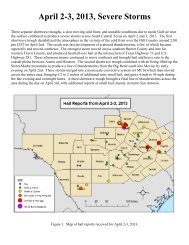
Record Drought Likely to Persist or Reintensify<br />
The crystal ball, which includes a number of large scale forecast parameters, bodes poorly for overall drought<br />
improvement. Only a Slow Moving Tropical Storm, Hurricane, or Series of Tropical Waves Can Relieve This<br />
Drought. The latest <strong>National</strong> “Droughtlook” from NOAA’s Climate Prediction Center through the end of August (next<br />
page) hints at very slight improvements for the Lower Valley; this may be due to climatological proximity to Gulf coast<br />
sea breeze thunderstorms and outer impacts from distant tropical cyclones or waves. Otherwise, the entire Rio<br />
Grande Basin remains in “persistent” drought for the foreseeable future.
If the forecast is successful, the Valley’s water supply will be in uncharted territory by summer’s end. Three reasons<br />
contribute to this dire prediction:<br />
Continued record low 24 to 30 month precipitation values for the Rio Grande Valley and Rio Grande Plains<br />
Highest population on record for both sides of the border (2.6 million+)<br />
An estimated potential crop and livestock economy surpassing $1 billion at the end of 2012<br />
Near-record low lake levels at Amistad International Reservoir before peak summer evaporation begins.<br />
Amistad often releases water to keep a viable level at Falcon International Reservoir.<br />
Above: Graphic showing steady, pronounced lake level drop at Amistad since winter 2012. Bottom chart shows current level (solid blue),<br />
below the prior 22 year low point. Double red arrow shows difference from 2012 levels to those in mid-May, 2013.
Falcon International Reservoir (right)<br />
fluctuated in late April and May for<br />
multiple reasons. Irrigation releases in<br />
late March and early April brought lake<br />
levels (Texas share) close to 15% of<br />
conservation. Releases from Amistad to<br />
replenish Falcon, combined with<br />
temporary relief from rainfall in the basin<br />
(Rio Salado area of Mexico) raised levels<br />
to 27% by mid-May. Unfortunately,<br />
Amistad has very little water to supply<br />
downstream, and heat, wind, and sun will<br />
begin to accelerate evaporation rates<br />
which will allow a steady fall to commence<br />
in late May and likely continue through<br />
August, barring a tropical cyclone or<br />
series of waves.<br />
The chart below shows just how intense,<br />
and persistent, the drought has been for virtually all of the Valley’s population (Cameron, Hidalgo, Willacy) since the<br />
spigot was turned off at the end of September, 2010 . The data also filter out periodic, welcome rain events through<br />
the period (seven Valley-wide events have been recorded between September 2010 and May 2013). Despite<br />
widespread 1 to 3 inches of rain to close April and push monthly totals above the 30-year average, the 30-month<br />
total since November, 2010, indicated only 32.77 inches had fallen! Based on the nearly 120 years of data, the<br />
chance for values this low is between 1 and 2 percent.
Blame it on NAO: Negative Phase the New <strong>Summer</strong> Normal?<br />
Past articles have described the puzzle pieces that define a summer season for the Rio Grande Valley. Many look to<br />
El Niño/<strong>Southern</strong> Oscillation (ENSO) to improve seasonal predictability, particularly in winter (rainy vs. dry, warm vs.<br />
cool) and summer (more tropical cyclones vs. fewer). The reality of impact goes well beyond ENSO in any summer<br />
but perhaps more this year, as the ENSO phase is squarely forecast to remain neutral. Neutral phase ENSO adds<br />
little information to the forecast season, other than not to impact the effectiveness of the very warm waters in the<br />
Main Development <strong>Region</strong>.<br />
We’ve noticed something else the past few years: A persistent and sometimes pronounced negative phase of the<br />
Arctic Oscillation (AO) and North Atlantic Oscillation (NAO) from June to late August in 2011 and 2012. <strong>Summer</strong>time<br />
negative AO/NAO phases have tended negative since 2009 and may correlate with the overall tropical cyclone<br />
tracks.<br />
A summertime negative phase of the AO and NAO has less direct impact on the weather than in winter. Still, a<br />
“shadow effect” appears to produce occasional upper level troughs along or near the U.S. east coast, which can<br />
bring impacts including damaging wind and hail storms to the mid-Atlantic and Northeast, searing heat waves along<br />
the southern edge of the trough, and a few more cooling fronts with modified Canadian air masses. One key impact<br />
is the ability of the trough to steer many tropical cyclones clear of the U.S. East Coast, which occurred in 2010, 2011,<br />
and 2012. To the west of the trough, atmospheric high pressure will shift from northern Mexico into the southern<br />
Great Plains of Oklahoma, and sometimes extend well north into the Great Plains and Mississippi Valley. Such a<br />
northward extension contributed to near record drought and billions of dollars in crop production loss in 2012.<br />
What’s Next?<br />
The NAO showed took a decidedly negative turn from late<br />
February through mid-April, and may have contributed to<br />
the ability of Canadian air masses to reach deep into Texas<br />
and northern Mexico, which finished off multi-year streaks<br />
of above average monthly temperatures for the Rio Grande<br />
Valley in April. The shift to a positive phase to close April<br />
and begin May could have aided the periodic rains, but<br />
more needs to be researched to draw a conclusion.<br />
Unfortunately, AO/NAO phases are near impossible to<br />
forecast beyond two to three weeks out. The ensemble<br />
forecast at lower right describes a return to neutral/negative<br />
NAO phase headed into June. The million dollar question –<br />
literally – remains: Will June-August 2013’s AO/NAO look<br />
like those above? Past seasons, as well as one peer<br />
reviewed study that suggests a correlation between<br />
accelerating arctic sea ice and a more frequent negative<br />
AO/NAO phase, suggest the answer is yes.
Time will tell. Should the negative phase win the summer, the weather pattern might have a general look to it, as<br />
shown below (based on a deterministic forecast for early June).<br />
One possible pattern outcome for summer 2013: “La Canícula” High pressure oscillates between the <strong>Southern</strong> Plains and Sonora, Mexico. A shadow east<br />
coast trough would tend to “pick up” and recurve tropical cyclone along or well east of the U.S.; Canícula would effectively lock the door for any northward<br />
progression of west moving cyclones at low latitudes.<br />
Comprehensive Water Management is Crucial<br />
This drought will end, in time. But long term climate models and continued rapid population growth across the Valley<br />
on both sides of the border urge the area to embark on long term water management plans. Such plans will be<br />
devised at higher levels of government. In real time, the water crisis will continue and could worsen in many<br />
communities. Water conservation is paramount, and doing your part can ensure that there’s enough water to make it<br />
through what could be a difficult summer. The following conservation tips can help your family and community this<br />
summer and beyond.<br />
Water Conservation<br />
o Take fewer and shorter showers.<br />
o Install low-flow toilets, faucets, and shower heads.<br />
o Recycle used household water for plant irrigation rather than turning on the spigot.<br />
o Repair leaky faucets, showers, or other plumbing.<br />
o Check appliances, such as dishwashers and clothes washers, for water efficiency.<br />
o Let your grass grow to better accept condensation from dew, and irrigate infrequently.<br />
o Wash cars seldom.<br />
o Consider rain barrels (cisterns) to collect whatever falls this spring. . Check out how on page 3 of the Winter 2013<br />
Coastal Breeze web letter.<br />
o You may also want to collect condensate water from air conditioning units. Consider becoming drought tolerant.<br />
Xeriscape or landscape with drought-hardy plants.<br />
o Read more Texas water conservation tips here.
Energy Conservation<br />
Hot, dry weather is typically a drain on electricity. We’re all in this together; the energy you save can save you and<br />
your community money – or more – during exceptional drought.<br />
o Check your walls, foundation, and roof for air leaks.<br />
o <strong>Service</strong> your heating, ventilation, and air conditioning (HVAC) units to ensure they are not using excessive energy.<br />
o Set your thermostat to a higher temperature when you’re not home<br />
o Install or use an attic fan to improve ventilation<br />
o Read more Texas energy conservation tips here.