The goal is - MODIS Atmosphere - NASA
The goal is - MODIS Atmosphere - NASA
The goal is - MODIS Atmosphere - NASA

You also want an ePaper? Increase the reach of your titles
YUMPU automatically turns print PDFs into web optimized ePapers that Google loves.
T<br />
hese days, we frequently hear or read news<br />
about global warming, ozone depletion, acid<br />
rain, desertification, and loss of biodiversity,<br />
and wonder what the quality of life on Earth<br />
will be like in the future. Unfortunately, too few data<br />
currently ex<strong>is</strong>t to provide an adequate description. We<br />
know that there have been warming and cooling trends<br />
throughout the Earth’s h<strong>is</strong>tory, and that global climate<br />
change has ar<strong>is</strong>en from natural causes. However, now<br />
there <strong>is</strong> compelling scientific evidence that global climate<br />
change <strong>is</strong> being accelerated by human activities.<br />
Through widespread activities related to increasing<br />
urbanization-such as deforestation and biomass<br />
burning, or industrial and automobile em<strong>is</strong>sionsmankind<br />
<strong>is</strong> conducting an uncontrolled experiment on<br />
the Earth’s environment without knowing what the<br />
consequences will be. Decades ago, scient<strong>is</strong>ts began<br />
ra<strong>is</strong>ing critical questions concerning global climate<br />
change in hopes of differentiating human-induced climate<br />
change from natural fluctuations. In 1988, scient<strong>is</strong>ts<br />
from the Intergovernmental Panel on Climate<br />
Change (IPCC) met in hopes of bringing their questions<br />
and concerns to the forefront of the Earth science<br />
agenda. Two years later, the U.S. Global Change<br />
Research Program (USGCRP) identified key areas of<br />
uncertainty in global climate change. In the early I98Os,<br />
<strong>NASA</strong> began planning the Earth Observing System<br />
(EOS), the primary initiative in its M<strong>is</strong>sion to Planet<br />
Earth to provide scient<strong>is</strong>ts with the tools needed to<br />
meet the <strong>goal</strong>s set forth by the USGCRP and IPCC-to<br />
develop a better understanding of our planet with<br />
which to ass<strong>is</strong>t policymakers worldwide to protect and<br />
manage our environment and natural resources more<br />
effectively and efficiently.<br />
EOS cons<strong>is</strong>ts of three components’s? a space-based<br />
observing system compr<strong>is</strong>ed of a series of satellite sen-<br />
sors by which scient<strong>is</strong>ts can monitor the Earth, a Data<br />
and Information System (EOSDIS) enabling re-<br />
searchers worldwide to access the satellite data, and an<br />
interd<strong>is</strong>ciplinary scientific research program to inter-<br />
pret the satellite data. <strong>The</strong> objectives of EOS’ are to:<br />
Establ<strong>is</strong>h an integrated, sustained, and comprehen-<br />
sive program to observe the Earth on a global scale;<br />
Conduct focused and exploratory studies to improve<br />
understanding of the physical, chemical, biological,<br />
and social processes that influence the Earth’s climate;<br />
Develop models of the Earth system to integrate and<br />
predict climate changes; and<br />
Assess impacts of natural<br />
ties on the Earths climate.<br />
events and human activi-<br />
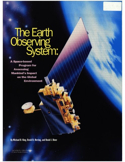
<strong>The</strong> first EOS spacecraft, EOS AM-l (Fig. l), will<br />
launch in 1998. “AM-l” means that the satellite will fly<br />
in a sun-synchronous polar orbit, descending southward<br />
across the equator at IO:30 a.m. In 2000, EOS PM-<br />
1 will be launched into a sun-synchronous polar orbit<br />
Figure 1 @OR). An art<strong>is</strong>t’s rendering of the EOS AM-l Platform.<br />
<strong>The</strong> first in a series of EOS satellites. AM-l will launch in 1998<br />
carrymg a payload of five umque, highly specialized Earth sensors.<br />
ascending northward across the equator at 1:30 p.m. Six<br />
years after AM-l, EOS AM-2 will launch, followed by<br />
EOS PM-2, and so on. Other EOS satellites include<br />
Radar Altimetry (launches in 1999), EOS Chem<strong>is</strong>try<br />
(launches in 2002), and Laser<br />
Altimetry (launches in 2003).<br />
Additionally, there are a number “<strong>The</strong> <strong>goal</strong> <strong>is</strong><br />
of EOS sensors on flights of<br />
opportunity, including interna-<br />
tional spacecraft; e.g., SeaWinds,<br />
which will fly aboard Japan’s<br />
to construct<br />
models of<br />
ADEOS II satellite in 1999.<br />
Overall. the EOS Program will IlEm<br />
provide’a 15-year global dataset<br />
of many atmospheric, terrestrial, global<br />
and oceanic properties.<br />
EOS AM-l will carry a payload<br />
of five unique,. highly<br />
dynamics”<br />
soph<strong>is</strong>ticated sensors for measuring Earth’s features and<br />
processes: the Moderate Resolution Imaging<br />
Spectroradiometer (<strong>MODIS</strong>), the Multi-angle Imaging<br />
SpectroRadiometer (MISR), the Advanced Spaceborne<br />
<strong>The</strong>rmal Em<strong>is</strong>sion and Reflection Radiometer (ASTER),<br />
the Clouds and the Earth’s Radiant Energy System<br />
(CERES), and the Measurement of Pollution in the<br />
Troposphere (MOPITT). <strong>The</strong> focus of th<strong>is</strong> article <strong>is</strong> on<br />
EOS AM-l, with particular emphas<strong>is</strong> on <strong>MODIS</strong> and<br />
MISR.<br />
Through observation and measurement, scient<strong>is</strong>ts have<br />
learned that atmospheric constituents-such as clouds,<br />
gases, and aerosols (stratified hazes and dust layers)profoundly<br />
affect the Earth’s land and oceans; and as<br />
changes occur on the land and in the oceans, they in<br />
turn profoundly affect the atmosphere.3 Scient<strong>is</strong>ts conclude<br />
that the relationship between land, oceans, and<br />
atmosphere <strong>is</strong> cyclical and tightly interwoven. So, to<br />
better understand natural global climate change, as well<br />
as mankind’s role in accelerating these changes, scient<strong>is</strong>ts<br />
must study the Earth as a whole integrated and<br />
interacting ecosystem. <strong>The</strong> <strong>goal</strong> <strong>is</strong> to construct models<br />
of the Earth’s global dynamics-atmospheric, oceanic,<br />
and terrestrial-and predict changes before they occur.<br />
Before scient<strong>is</strong>ts can begin to understand and accurately<br />
model global dynamics, they need information in<br />
the form of data. To differentiate short-term trends<br />
from long-term, as well as to d<strong>is</strong>tingu<strong>is</strong>h regional phenomena<br />
from global, these data must be collected every<br />
day for a long period of time (at least 15 years) and<br />
should represent every region of the Earth’s lands,<br />
oceans, and atmosphere. Satellite sensors serve as an<br />
effective means for collecting these needed data, primarily<br />
by remote sensing of certain key attributes of the<br />
electromagnetic<br />
Earth.<br />
radiation reflected and emitted by the<br />
Our planet <strong>is</strong> continually bathed in electromagnetic<br />
radiation from the Sun, which directly or indirectly<br />
Speclal Issue/Remote Sensing Optics & Photonics News/January 1995 35
drives most of the Earth’s surface dynamics. Solar radi-<br />
ation entering the atmosphere <strong>is</strong> either reflected back<br />
into space, absorbed by suspended particles (such as<br />
aerosols or clouds), or transmitted to the Earth’s sur-<br />
face, where again it <strong>is</strong> either reflected, absorbed, or<br />
transmitted. Depending on their chemical composition,<br />
all objects reflect, absorb, or transmit radiant energy<br />
character<strong>is</strong>tically in certain bands of the electromagnet-<br />
ic spectrum. For example, in the v<strong>is</strong>ible spectrum, the<br />
pigments in certain species of phytoplankton preferen-<br />
tially absorb red and blue light and reflect green, Using<br />
satellite-based measurements to infer the abundance of<br />
these organ<strong>is</strong>ms quantitatively <strong>is</strong> challenging because<br />
the intervening atmosphere influences the character<strong>is</strong>-<br />
tics of the observed signal. <strong>The</strong>refore, it will be neces-<br />
sary to measure character<strong>is</strong>tics of the atmosphere, in<br />
Solar ditTuser<br />
Spectroadiometric<br />
calibrator<br />
\ /<br />
<strong>The</strong>rmafblanket \<br />
Main electronics module<br />
Radiative cooler door and<br />
Earth shield<br />
Flgura 2. A cutaway view of the <strong>MODIS</strong> Instrument illustratmg<br />
some of Its essential components for calibration. <strong>MODIS</strong> will have<br />
unprecedented capabilltles to characterize instrument performance<br />
whale I” orbat.<br />
addition to those on the Earth’s surface, so that scien-<br />
t<strong>is</strong>ts may infer the conditions of both.4<br />
<strong>The</strong> instruments that will fly aboard EOS spacecraft<br />
are well-designed to take measurements in seven key<br />
areas of scientific uncertainty related to global<br />
change?<br />
1. Sources and sinks of greenhouse gases, which affect<br />
predictions of their future concentrations and global<br />
warming;<br />
2. Clouds and the Earth’s radiation balance, which<br />
strongly influence the magnitude of climate change;<br />
3. Oceans, which are the heat engine of global climate<br />
and influence the timing and patterns of climate<br />
change;<br />
4. Land surface hydrology, which affects regional cli-<br />
mate and water availability for agricultural and indus-<br />
trial development;<br />
5. Polar ice sheets, which affect predictions of global sea<br />
level;<br />
6. Ecological dynamics, such as vegetation patterns, bio-<br />
logical diversity, and carbon cycling, which are affected<br />
by and affect climate change; and<br />
7. Volcanoes, which can add materials to the atmos-<br />
phere that cause short-term climate change.<br />
Modederesolutionimagingspecbwadii<br />
Currently being developed by Hughes Santa Barbara<br />
Research Center, <strong>MODIS</strong> will be a key instrument on<br />
each of the EOS Ah1 and PM satellites (see Fig. 2).<br />
<strong>MODIS</strong>’ objective <strong>is</strong> to provide a comprehensive series<br />
of global observations of the Earth’s land, oceans, and<br />
atmosphere in the v<strong>is</strong>ible and infrared regions of the<br />
spectrum in 36 spectral bands ranging from 0.405 to<br />
14.385 urn. Here, the word “comprehensive” refers to<br />
the wide spectral range and spatial coverage, as well as<br />
the continuous coverage <strong>MODIS</strong> will provide over<br />
time. With its swath width of 2,330 km, <strong>MODIS</strong> will<br />
view the entire surface of the Earth every 1 to 2 days.<br />
Additionally, <strong>MODIS</strong> <strong>is</strong> “comprehensive” in that it<br />
will continue to take measurements in spectral regions<br />
that have been and are currently being measured by<br />
other satellite sensors, or “heritage instruments.”<br />
Subsequently, <strong>MODIS</strong> will extend data sets taken by<br />
such instruments as the Advanced Very High<br />
Resolution Radiometer (AVHRR), used for meteorolo-<br />
gy and monitoring sea surface temperature, sea ice, and<br />
vegetation; and the Coastal Zone Color Scanner<br />
(CZCS), used to monitor oceanic biomass and ocean<br />
circulation patterns. 4s However, it should be noted that<br />
<strong>MODIS</strong> will meet or exceed the capabilities of all of its<br />
heritage instruments. “Comprehensive” also refers to<br />
the unified nature of <strong>MODIS</strong>’ observations, necessary<br />
for multid<strong>is</strong>ciplinary studies of land, ocean, and atmos-<br />
pheric processes and their interactions. In short,<br />
<strong>MODIS</strong> will be a central tool on the EOS satellites for<br />
conducting global change research. <strong>MODIS</strong> data will be<br />
used by all other EOS AM- 1 instrument teams to com-<br />
plement their respective science data products.<br />
allboaldcallbration<br />
Technologically, <strong>MODIS</strong> will break new ground in<br />
onboard calibration. No other spectroradiometer has<br />
been able to measure the spectral location of its bands<br />
while in orbit. <strong>MODIS</strong> will have th<strong>is</strong> capability, as well<br />
as the unprecedented capability to measure band-to-<br />
band reg<strong>is</strong>tration while in orbit. Until now, scient<strong>is</strong>ts<br />
have had to assume that pre-launch, band-to-band reg-<br />
<strong>is</strong>tration remains the same after launch, and that the<br />
spectral purity of bands remains unchanged for the life<br />
of the m<strong>is</strong>sion. <strong>The</strong>re <strong>is</strong> some evidence that there have<br />
been in-orbit spectral changes in heritage satellite sen-<br />
sors. If an in-orbit spectral shift should occur in<br />
<strong>MODIS</strong>, it will be measured and characterized.6<br />
Moreover, in addition to using the sun and moon as<br />
shortwave calibration sources and an internal blackbody<br />
as a longwave calibration source, <strong>MODIS</strong> will continual-<br />
ly monitor any degradation of the solar diffuser that<br />
allows it to look directly at the sun (see Fig. 3).6<br />
Improved science capabilii<br />
Although <strong>MODIS</strong> will not contain revolutionary new<br />
optics technology, it does stretch current state-of-the-<br />
art to new limits for new scientific applications.<br />
<strong>MODIS</strong> contains a cross-track scanning mirror and a<br />
set of linear detector arrays with spectral interference<br />
filters located in four focal planes.6 <strong>The</strong> challenge has<br />
36 Optics & Photonlcs News/January I.995 Special Issue/Remote Sensing
j”<br />
‘.<br />
Optical benchbuss<br />
/ Vfor<br />
System electronics<br />
J<br />
CaliJmtion p<br />
pildaa A. Layout of the MISR instrument illustrating ti-<br />
strticture. base plate. and optvxl bench. which holds 1<br />
<strong>The</strong> primary support structure attaches to the EOS AN<br />
bese ptate maintains rigid support for the optkcal bent<br />
TEC hot junction<br />
thermal exchange<br />
H/W<br />
Camera head elec<br />
Adjustment Ranger<br />
rge coupled device<br />
camem contains a refractive f/5.5 telecentrlc lens ant<br />
supply and seral data interfaces<br />
as their optical properties at each scene.8 Clouds and<br />
aerosols both play a major role in climate. Over land,<br />
MISR’s multi-angle views will enable scient<strong>is</strong>ts to<br />
study the impact of land processes on climate. For<br />
vegetated terrain in particular, MISR data will enable<br />
scient<strong>is</strong>ts to study vegetation reflectance relative to<br />
canopy structure. Here, MISR will particularly com-<br />
plement <strong>MODIS</strong>-its multi-angle observations will<br />
help scient<strong>is</strong>ts interpret directional vegetation<br />
indices acquired by <strong>MODIS</strong> MISR’s multi-angle<br />
imagery will help scient<strong>is</strong>ts classify land vegetation<br />
worldwide, as well as derive photosynthes<strong>is</strong> and<br />
transpiration rates.<br />
38 OPTICS & Photonics News/January 1995<br />
MlSR uses detector-based calibration techniques, both<br />
pre-flight and in-flight to achieve a radiometric scale.<br />
Detector standards are more accurate than convention-<br />
al source standards, and are used at national standards<br />
labs such as NIST (U.S.) and NPL (U.K.). MISR <strong>is</strong> the<br />
first spaceborne instrument to introduce high quantum<br />
efficiency (HQE) diode technology as part of in-flight<br />
calibration, which <strong>is</strong> expected to reduce calibration<br />
uncertainties by a factor of two from conventional<br />
methods.<br />
<strong>The</strong> HQE diodes used as part of MISR’s on-board<br />
calibrator (OBC) are silicon detectors with high inter-<br />
nal quantum efficiency. Three of these diodes are pack-<br />
aged in a “light trapping” configuration, such that light<br />
that <strong>is</strong> reflected (i.e., undetected) by the first diode illu-<br />
minates the second diode, where it has another oppor-<br />
tunity for capture; light reflected there hits the third<br />
diode and <strong>is</strong> then reflected back to the second and first<br />
diodes for a total of five opportunities for capture. <strong>The</strong><br />
output from the three diodes <strong>is</strong> summed together, giv-<br />
ing the entire device a near-loo% quantum efficiency.<br />
MISR uses four such packages, each optimized for one<br />
of the MISR spectral bands. <strong>The</strong> diode filters have the<br />
same spectral character<strong>is</strong>tics as the filters used for the<br />
camera CCDs.<br />
In addition to the HQE devices, highly radiation-<br />
res<strong>is</strong>tant PIN photodiodes are used as part of the MISR<br />
OBC as a secondary detector standard. Th<strong>is</strong> standard<br />
typically exhibits higher environmental stability relative<br />
to the HQEs. However, environmental testing has<br />
demonstrated a higher level of charged particle radia-<br />
tion res<strong>is</strong>tance for the HQEs used for MISR Bands l-3<br />
than previously expected, which should enable full<br />
reliance on these devices throughout the m<strong>is</strong>sion.<br />
Several sets of PIN diodes are mounted on the MISR<br />
optical bench, and one set <strong>is</strong> mounted on a mechanized<br />
goniometer to obtain bidirectional reflectance measure-<br />
ments of the calibration panels.<br />
spe&abndiipanels<br />
MISR incorporates two deployable diffusely-reflecting<br />
panels for calibration of the cameras. In evaluating<br />
materials to be used for these panels, considerations<br />
including Lambertian reflectance (which <strong>is</strong> important<br />
because the cameras view each panel from different<br />
angles), spatial uniformity, high hem<strong>is</strong>pherical<br />
reflectance, low contamination, effects of static charge<br />
build-up, and mechanical robustness were taken into<br />
account. <strong>The</strong> material chosen for the panels <strong>is</strong><br />
Spectralon, a form of sintered polytetrafluoroethylene.<br />
MISR has provided for the flight qualification of th<strong>is</strong><br />
material. Because of MISR’s reliance on detector-based<br />
calibration as described above, it <strong>is</strong> not necessary for<br />
the panel reflectance to remain invariant throughout<br />
the EOS m<strong>is</strong>sion. Studies involving exposure of<br />
Spectralon to W radiation in vacuum, however, indi-<br />
cate that the material’s reflectance at the MISR wave-<br />
lengths <strong>is</strong> stable to better than 2% in the blue with even<br />
better performance at the longer wavelengths. To<br />
achieve th<strong>is</strong> stability, special cleaning and handling<br />
Speclal Issue/Remote SeansIng
methods have been developed to ensure against conta-<br />
mination by photoactive hydrocarbons.<br />
UlSdataandifdtmathSystem<br />
<strong>The</strong> EOS Data and Information System (EOSDIS) <strong>is</strong><br />
one of the most exciting features of the EOS Program-<br />
users will not need in-depth knowledge of remote sens-<br />
ing technology to use EOS data. Each instrument sci-<br />
ence team will be responsible for the quality of its data<br />
products. EOSDIS will receive, process, store, and ren-<br />
der these data available internationally to the Earth sci-<br />
ence community, as well as policymakers, resource<br />
planners, and commercial users.9 It <strong>is</strong> estimated that<br />
EOS AM- 1 alone will collect 1 to 2 terabytes of data per<br />
week. To make these data easily accessible to its diverse<br />
users, EOSDIS will use advanced technology for data<br />
management, compression, and d<strong>is</strong>tribution. Although<br />
EOSDIS will be geographically d<strong>is</strong>tributed throughout<br />
the U.S., users will access the system with a single com-<br />
puter interface, so it will appear to them as a single<br />
entity. Users will connect to EOSDIS using any one of<br />
several Internet networks, including the <strong>NASA</strong> Science<br />
Internet and the National Research and Education<br />
Network, currently under development.Lo <strong>The</strong> idea <strong>is</strong> to<br />
make accessible calibrated, validated global data prod-<br />
ucts and encourage the international Earth science<br />
community to perform the analyses.<br />
Anyone interested in learning more about EOS, or<br />
browsing sample remote sensing images, should refer to<br />
the EOS Project Science Office Home Page available via<br />
Mosaic on the World Wide Web. <strong>The</strong> URL (Uniform<br />
Resource Locator) <strong>is</strong> http://spso.gsfc.nasa.gov/<br />
spso-honepage.html<br />
lllebigpictwe<br />
In scope and complexity, EOS <strong>is</strong> an awesome endeavor.<br />
It involves the synerg<strong>is</strong>tic union of researchers from a<br />
broad range of scientific d<strong>is</strong>ciplines working together<br />
to, for the first time ever, understand the Earth as a<br />
whole, integrated system. EOS AM- 1 employs the inter-<br />
nationally d<strong>is</strong>tributed science and technical teams of<br />
five highly specialized instruments working together, in<br />
complementary fashion, to collect what will become the<br />
largest dataset in h<strong>is</strong>tory. <strong>The</strong> <strong>goal</strong> <strong>is</strong> to construct mod-<br />
els of the Earth’s global dynamics-atmospheric,<br />
oceanic, and land surface-enabling scient<strong>is</strong>ts to pre-<br />
dict climate changes before they occur. Scient<strong>is</strong>ts also<br />
hope to differentiate between natural and human-<br />
induced climate change. Ultimately, EOS will ass<strong>is</strong>t pol-<br />
icymakers worldwide in making sound dec<strong>is</strong>ions con-<br />
cerning the protection and management of our envi-<br />
ronment and resources.<br />
References<br />
1. “<strong>NASA</strong>’s M<strong>is</strong>sion to Planet Earth: Earth Observing System,” National<br />
Aeronautics and Space Admin<strong>is</strong>tration, Government Printing Office.<br />
Washington, DC, <strong>NASA</strong> PA??-552 (1994).<br />
2. G. Asrar and 1. Dozier. Science Strategy for the Earth Observing System,<br />
American Institute of Physics, AIP Press, Woodbury, N.Y. (1994).<br />
3. M.D. King et al., “Remote sensing of cloud, aerosol, and water vapor<br />
properties from the Moderate Resolution Imaging Spectrometer<br />
(<strong>MODIS</strong>),” IEEE Trans. Geosci. Remote Sens. 30.2-27 (1992).<br />
Special Iwe/Remote Sendng<br />
4.<br />
5.<br />
6.<br />
7.<br />
8.<br />
9.<br />
10<br />
M. D. King and M. K. Hob<strong>is</strong>h, “Sxellite instrumentation and imdgcry,”<br />
Encyclopedia of Climate and Weather, Oxford University Press, New<br />
York, 1995, in press.<br />
P.E. Ardanuy et al.. “<strong>The</strong> Moderate Resolution Imaging Spectrometer<br />
(<strong>MODIS</strong>) science and data system requirements.” IEEE Trans. Geosci.<br />
Remote Sens. 29,75-88 (1991).<br />
M. K. Hob<strong>is</strong>h ef nl.. “Surface imaging technologies for <strong>NASA</strong>’s Earth<br />
Observing System,” J. Imag. Sci. Tech. 38,301-310 (1994).<br />
I. Townshend et al., “Global land cover classification by remote sensing:<br />
Present capabilities and future possibilities,” Remote Sens. Environ. 35,<br />
243-255 (1991).<br />
D. J. Diner er al., “Bidirectional reflectance measurements from space<br />
with the EOS Multi-angle Imaging Spectroradiometer (Paper 694.0598):’<br />
AIM 32nd Aerospace Meeting, AIAA. Rena. Nev. (1994).<br />
R. D. Price et aL, “Earth science data for all: EOS and the EOS data and<br />
information system,” Photogramm. Eng. Remote Sens. 60, 277-286<br />
(1994).<br />
EOS Reference Handbook, G. Asrar and D. J. D&ken, eds.. National<br />
Aeronautics and Space Admin<strong>is</strong>tration, Government Printing Office,<br />
Washington, D.C., <strong>NASA</strong> NP-202 (1993).<br />
Michael D. King <strong>is</strong> senior project scienr<strong>is</strong>r of <strong>NASA</strong>’s Earth Observing System<br />
at <strong>NASA</strong> Goddard Space Flight Center, Greenbelt, Md., and <strong>is</strong> a member of<br />
the <strong>MODIS</strong> and CERES Science Teams. David D. Herring <strong>is</strong> P member of the<br />
<strong>MODIS</strong> Admin<strong>is</strong>~rativc Support Team at <strong>NASA</strong> Goddard Space Flight<br />
Center, working for Science Systems and Applications Inc. David J. Diner <strong>is</strong><br />
principal investigator of the MISR Science Team at the Jet Propulsion<br />
Laboratory, California Institute of Technology, Pasadena, Calif