

Lithostratigraphical framework for Carboniferous successions of ...
Lithostratigraphical framework for Carboniferous successions of ...
Lithostratigraphical framework for Carboniferous successions of ...

You also want an ePaper? Increase the reach of your titles
YUMPU automatically turns print PDFs into web optimized ePapers that Google loves.
Uplands<br />
60°N<br />
5°W 0°<br />
5°W 0°<br />
5°W<br />
0°<br />
a) Mid Tournaisian<br />
60°N b) Early Visean<br />
60°N c) Late Visean<br />
(Arundian)<br />
(Brigantian)<br />
Emergent areas<br />
Alluvial<br />
Alluvial<br />
‘Barren Measures’ facies<br />
‘Coal Measures’ facies<br />
Periodic marine<br />
influence<br />
V<br />
V<br />
SUH<br />
V<br />
MVS<br />
V V<br />
SUH<br />
V<br />
M-LD<br />
MVS<br />
Alluvial<br />
‘Millstone Grit’ facies<br />
G-MH<br />
CB<br />
DB<br />
NT<br />
AIB<br />
AsB<br />
CB<br />
CLH<br />
V<br />
55°N<br />
NT<br />
CH<br />
55°N<br />
55°N<br />
V<br />
G-MH<br />
Alluvial<br />
AIB<br />
G-MH<br />
‘Yoredale’ and coastal facies<br />
V<br />
AsB<br />
M-LD<br />
?<br />
V<br />
WT DH<br />
DB<br />
Alluvial<br />
plains<br />
CB<br />
?<br />
Hemi-pelagic facies<br />
V<br />
V<br />
Wales-Brabant<br />
High<br />
SB<br />
V<br />
SB<br />
Wales-Brabant High<br />
Plat<strong>for</strong>m and ramp carbonate facies<br />
Heterolithic clastic and nonmarine carbonate facies<br />
V<br />
V<br />
V<br />
Continental and peritidal facies<br />
50°N<br />
50°N<br />
50°N<br />
Principal direction <strong>of</strong> clastic input<br />
0°<br />
60°N<br />
5°W<br />
f) Late Westphalian<br />
(Westphalian D)<br />
0°<br />
60°N<br />
5°W<br />
e) Early Westphalian<br />
(Langsettian)<br />
0°<br />
60°N<br />
5°W<br />
d) Early Namurian<br />
(Arnsbergian)<br />
4<br />
Volcanicity<br />
V V V V V<br />
V<br />
V<br />
V<br />
V<br />
SUH<br />
55°N<br />
55°N<br />
55°N<br />
G-MH<br />
SUH<br />
Pennine<br />
Basin<br />
Pennine<br />
G-MH<br />
G-MH<br />
V<br />
Basin<br />
Wales - Brabant High<br />
Wales-Brabant High Wales - Brabant High<br />
LH<br />
V<br />
Pennant<br />
CuB<br />
50°N<br />
50°N<br />
50°N<br />
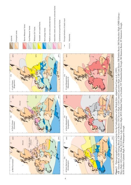
Figure 2 palaeogeographical reconstructions <strong>for</strong> the <strong>Carboniferous</strong> <strong>of</strong> the British isles, adapted from Cope et al. (1992).<br />
alB alston Block; asB askrigg Block; CB Craven Basin; CH Cheviot High; CLH Central Lancashire High; CuB Culm Basin; dB dublin Basin; dH derbyshire High; GmH Galway–<br />
mayo High; LH Leinster High; m-Ld manx–Lake district High; mvs midland valley <strong>of</strong> scotland; NT Northumberland Trough; sB shannon Basin; sT stainmore Trough;<br />
suH southern uplands High; wT widmerpool Trough


