Create successful ePaper yourself
Turn your PDF publications into a flip-book with our unique Google optimized e-Paper software.
110 MONTHLY WEATHER REVIEW MARCH 1935<br />
Several ships encountered gales in the waters southwest<br />
of Ireland on the 1st. The British steamship<br />
Jamaica Producer recorded force 11. Thereafter conditions<br />
were less stormy until the 8th, when the highpressure<br />
area over northwestern Europe showed increased<br />
strength and another strong anticyclone was nearing the<br />
lower Lakes in its southeastward movement toward the<br />
North Btlantic coast. Between these areas pressure<br />
was decidedly low south of Cape Farewell and rather low<br />
north of Bermuda. Several whole gales and a wind of<br />
force 11 were noted near mid-ocean on the 8th to 11th.<br />
The LOW from near Bermuda was by the 11th near the<br />
thirty-fifth meridian, while another LOW had begun to<br />
affect the west Gulf region.<br />
On the 12th (chart IX) low-pressure centers were near<br />
the Atlantic coast of the United States and near and to<br />
sou thward of southern Greenland, while high pressure<br />
extended from Bermuda to Madeira and thence northeastward<br />
to Norway. Strong winds were noted this day<br />
in many parts of the ocean where the gradient was steep;<br />
one instance of force 11 was reported by the Dutch<br />
motorship Tanimbar, close to 42' N., 40' W.<br />
Only a few gales were recorded on the 14th and 15th)<br />
but on the 16th the British motorship Irisbank noted<br />
force 11 east-northeast of Bermuda.<br />
Chart S shows the conditions of the 18th, when decidedly<br />
low pressure extended from Newfoundland eastward<br />
to within 400 miles of Ireland. Several instances<br />
of forces 9 to 11 were noted on or about this day, and the<br />
single instance of hurricane force (12) was recorded during<br />
the afternoon of the 17th) by the American steamship<br />
Quaker City which also reported the lowest pressure of<br />
the month, as noted above.<br />
After tbe 19th few gales of importance occurred east<br />
of the fortieth meridian and except during the 4-day<br />
period, 24th to 27th, not inany elsewhere. Decidedly<br />
low pressure was persistent during the latter period in the<br />
general region of Nova Scotia and Newfoundland, causing<br />
strong winds, alniost invariably from a southerly or<br />
westerly point, along the chief routes, mainly between the<br />
sixty-fifth and forty-fifth meridians. The French liner<br />
Paris recorded force 11 from the west at an early hour of<br />
the 25th, near 42' N., 51' W.<br />
. Vansel<br />
NORTH ATLANTIC<br />
OCEAN<br />
8. 8.<br />
Lustrous, Br. S. 5 _____ From-<br />
New York----<br />
London. - __ - __ Voyage<br />
Falmouth, Port Arthur.--. 42 ION.<br />
Eng.<br />
Steelmaker, Am. 5. 8-- CristobaL.-- London- - -. -. __ 39 34 N.<br />
Solana, Am. 8. S ._..__ New Orleans-. New York. - - ._ 30 30 N.<br />
London Corporation, Halifax _.______<br />
Liverpool - - - -. . 49 29N.<br />
Br. 8. 8.<br />
Leerdam, Du. 8. 8 Chester, Pa--- Rotterdam..-. . 48 32 N.<br />
Excelsior, Am. 8. 8 ____ Casablanca---- New York. - - __ 37 00 N.<br />
I February.<br />
TO-<br />
Copenhagen-.-.<br />
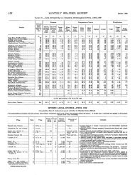
New York- - ___ OCEAN GALES AND STORMS, MARCH 1935<br />
Pastition at time of<br />
lowest barometer<br />
Latitudf<br />
0 ,<br />
City of Hamburg, Am. Norfolk. - __ ___ London- ___ - - -. 49 l2N.<br />
5. 8.<br />
Jamsles Producar, Br. Kingston. - - - -. Rotterdam.. - ._ 48 50 N.<br />
8. 8.<br />
Mercier Belg. 8. S---- Antwerp.---.. New York.. -. . 49 46 N.<br />
General' Qassouin, Fr. New York-.-. Antwerp.. - ._ _. 49 28 N.<br />
M. 8.<br />
Bodegraven. Du. 8. 5. CristobaL- - - - Liverpool- - __ -. 11 25N.<br />
Leerdam Du. 5. S---- Chester, Pa.-. Rotterdam.- - __ 39 33N.<br />
London ' Corporation, Halifax. ___ - __ . Liverpool.. ._ __ 43 00 N.<br />
Br. 8. 8.<br />
Frode, Dan. 5. S. _____ Emmingham, Halifax-.- - - - - -. 44 49 N.<br />
Eng.<br />
Maine Dan. 8. S ______ 55 30 N.<br />
Sandokn Castle, Br.<br />
49 15 N.<br />
Longitudf<br />
0 ,<br />
m 57 w .<br />
16 00 W.<br />
13 08 W.<br />
10 04 W.<br />
74 50 w .<br />
68 33 w .<br />
57 00 w.<br />
52 17 W.<br />
26 15 W.<br />
24 45 W.<br />
2520W.<br />
36 05 W.<br />
79 15 W.<br />
23 mw.<br />
28 00w.<br />
41 58 W.<br />
Qale<br />
mgan<br />
farct<br />
-<br />
~<br />
1<br />
' 26<br />
1<br />
1<br />
1<br />
3<br />
4<br />
4<br />
5<br />
6<br />
6<br />
5<br />
8<br />
8<br />
8<br />
0<br />
About the 8th and 9th) when pressure was notably<br />
high near Bermuda and Hatteras, there were several<br />
reports of gales from a northwesterly or northerly direc-<br />
t8ion, by vessels near the thirtieth parallel of latitude,<br />
between the Florida coast and the fifty-fifth meridian.<br />
The American stearnship Solam noted force 10 in this<br />
region.<br />
Trade winds of much greater force than usual were<br />
noted in the Caribbean Sea on the 2d and 12th.<br />
Fog.-There was more fog than there had been during<br />
February in some areas near the Gulf and Atlantic coasts<br />
of the United States, in parts of the Grand Banks region,<br />
and especially in and near the English Channel. In this<br />
last-named region fog was decidedly more prevalent than<br />
usual in March, as it was likewise near Delaware and<br />
Chesapeake Bays, and in the northwestern Gulf of<br />
Mesico.<br />
In other North Atlantic regions the fog situation was<br />
not far from normal, save from the waters adjacent to<br />
New England eastward nearly to the Grand Banks, where<br />
there was less fog than would be expected.<br />
The chief period of fog in waters bordering on England<br />
and northwestern France was the 18th to 21st; also the<br />
English Channel had considerable from the 26th to29th.<br />
The Grand Banks region noted widespread fog about the<br />
3d and for a period of fully a week near the middle of the<br />
month. The 5' square from 40' to 45' N., 45' to 50'<br />
W., reported fog altogether on nine different days of the<br />
nion t 11.<br />
Over the waters adjacent to Nova Scotia and New Eng-<br />
land there were scattered occurrences of fog during the<br />
first week and about the 12th. Near Delaware and<br />
Chesapeake Bays fog occurred chiefly about the 6th,<br />
12th, 20th, and 31st, and in the square 35' to 40' N.,<br />
70' to 75' W., there were 9 days during March on which<br />
fog was noted.<br />
From Cape Hatteras to southern Florida and in the<br />
northeastern Gulf of Mexico fog was very seldom met,<br />
but it was quite otherwise in the northwestern part of<br />
the Gulf. The waters in the square 25' to 30' N., 90'<br />
to 95' W., experienced fog from the 6th to 9th) and again<br />
from the 21st to 23d, ' days altogether.<br />
Low-<br />
ram-<br />
eter<br />
lnchea<br />
29.30<br />
29.33<br />
29.32<br />
29.06<br />
;&;i wind<br />
when<br />
gt:n<br />
--<br />
8W-.-.<br />
WNW.<br />
WSW-.<br />
w----.<br />
Direction<br />
and force<br />
offind<br />
attuneof<br />
lowest<br />
barometer<br />
29.71<br />
30.04<br />
29.51<br />
NE--..<br />
NNW.<br />
9<br />
29.29 w ___-_.<br />
29.62<br />
29.60<br />
ME--.<br />
5 ______.<br />
29.68 SSE ...<br />
29.54<br />
30.M<br />
29.47,<br />
29.16<br />
29.37<br />
wsw-.<br />
NE..-.<br />
SE-.--.<br />
8 _______<br />
88W-..<br />
Direc-<br />
tion or<br />
wind<br />
when<br />
gale<br />
ended<br />
Direotlon<br />
and high-<br />
eat force<br />
ofwlnd<br />
W,Q ______<br />
WNW, 11-<br />
WNW, 10<br />
W. 9 ______ NE, 8 _____ NW,10.-w,<br />
10 _____<br />
______<br />
8E.Q<br />
WNW,9--<br />
Shifts of wind<br />
near t he<br />
of lowest<br />
barometer<br />
8W-w.<br />
W-NNW.<br />
W-WSW-WNW.<br />
W-NW.<br />
None.<br />
SW-NW.<br />
8-w.<br />
w, 10 ___-_ W8W-w.<br />
8 10 ______ ________<br />
_---<br />
8: lo ____-_ 8-ssw-w.<br />
8.10 ______ S-WSW.<br />
NW 9---- 8W-W.<br />
NE 'lo-.-- W-NNW.<br />
SE,'ll---- Steady.<br />
88E-W-N.<br />
SSW-W.
MARCH 1935<br />
I<br />
Voyage<br />
MONTHLY WEATHER REVIEW<br />
OCEAN GALES AND STORMS, MARCH 1935-Continued<br />
1<br />
Position at time of<br />
lowest barometer<br />
sagaporack, Am. s. &-- Copenhagen.-- Portland. 5600N.<br />
, Maine.<br />
Tillie Lykes, Am. 8. 8.. Puetto Colom- Banto Domin- 11 39 N.<br />
bia.<br />
go.<br />
Tetela, Br. 8. 8 ________ Pto. Cortez, Rotterdam----- 44 50 N.<br />
Hond.<br />
Tanimbar, Du. M. 8--- Gibraltar<br />
Barbem, Am. 8. 8 ______ ______ Halifax _________ 41 44 N.<br />
San Juan _______ Philadelphia.-- 34 02 N.<br />
Oenerg Osssouin, Fr. Antwerp _______ New York..--. 42 07 N.<br />
Pres. Hsrding, Am. 8.<br />
8.<br />
Schoharie Am. 8. 8 __--<br />
Prea. Har'bg, Am. 8.<br />
8.<br />
NORTH PACIFIC<br />
OCEAN<br />
Nordbo, Dan. M. 8 _ ___<br />
I From- I TP I Latitude >ongitudt<br />
Is. -<br />
Cobh _ _________ New York..- -- 42 40N.<br />
38 40 N.<br />
Cobh ________._<br />
Bremen _ _______ Savannah ____--<br />
New Ynrk _ ____ 41 02 N.<br />
-<br />
Gale<br />
Time of Gale<br />
began<br />
lowest endec<br />
Marct Marc1 -<br />
March-<br />
-<br />
-<br />
11<br />
10<br />
11<br />
11<br />
12<br />
12<br />
12<br />
13<br />
15<br />
15<br />
17<br />
18<br />
18<br />
19<br />
18<br />
20<br />
20<br />
19<br />
21<br />
21<br />
23<br />
23<br />
22<br />
24<br />
24<br />
25<br />
26<br />
26<br />
27<br />
26<br />
29<br />
Inches<br />
28.94<br />
29.47<br />
28.32<br />
29.60<br />
29.61<br />
29.5s<br />
29.08<br />
29.66<br />
3.51<br />
30.15<br />
20.63<br />
29.21<br />
29.46<br />
29.49<br />
28.98<br />
a9-B<br />
29.15<br />
29.27<br />
29.14<br />
29.61<br />
29.64<br />
29.41<br />
I<br />
-<br />
Direction<br />
and force<br />
ofwind<br />
8 __-_--.<br />
8 __...-.<br />
SSE ___<br />
8 _ ______<br />
SW---.<br />
sw--..<br />
WNW<br />
1 SSW..:<br />
NE-.-.<br />
SW..-.<br />
NW--.<br />
8W ....<br />
sw..-.<br />
wsw-.<br />
w ______ wsw-.<br />
8SE.--.<br />
Direction<br />
of<br />
wind<br />
Vessel I I l- at time of when<br />
NORTH ATLANTIC<br />
OCEAN-Continued 0 ,<br />
8.<br />
Scanstates, Am. 8. S---<br />
Paris Fr. 8. S _.________<br />
Chey'enne. Br. M. 8 ____ Rotterdam..--. 146 56 N.<br />
Halifax _ ________ 41 18 N.<br />
Yorkmoar, Br. 8. S _____<br />
I Cam Verde I I<br />
34 30 W.<br />
33 59 w.<br />
24 30 W.<br />
74 37 w.<br />
40 38 W.<br />
40 18 w.<br />
73 4ow.<br />
28 15 W.<br />
23 15W.<br />
50 50 W.<br />
27 08 w.<br />
61 M)W.<br />
38 30 W.<br />
31 38 W.<br />
21 25 w.<br />
32 54 W.<br />
35 06 w.<br />
12 46 W.<br />
45 <strong>03</strong>w.<br />
40 61 W.<br />
40 08 w.<br />
8322W.<br />
30 00 W.<br />
58 20 w.<br />
67 00 W.<br />
50 42 W.<br />
58 68 W.<br />
61 40 W.<br />
44 35 w.<br />
48 00 W.<br />
83 40 W.<br />
2p, 10- - -<br />
68,11---<br />
2a, 12.--<br />
48, 12. -.<br />
loa, E.-<br />
Noon, 12<br />
?a, 13.--<br />
3p, 13---<br />
58. 15----<br />
48, 16---<br />
3p,17. -<br />
78, 1%-<br />
9s. 18. -<br />
108. 18lop,<br />
18.<br />
lop. 19loa,<br />
20.<br />
Noon,Z<br />
3p, 31. -<br />
6p. 2L 58, 23-..<br />
28, 24..-<br />
48. 24 ...<br />
3p, 2.. -<br />
Mdt, 24<br />
3a, 25. -<br />
lop, 26.<br />
4a, 27---<br />
Qa, 2iL.<br />
3p, zi. -<br />
3p, 29. -<br />
11<br />
11<br />
12<br />
13<br />
12<br />
12<br />
13<br />
13<br />
16<br />
16<br />
17<br />
18<br />
19<br />
22<br />
19<br />
21<br />
21<br />
3<br />
22<br />
22<br />
23<br />
24<br />
24<br />
25<br />
25<br />
35<br />
27<br />
n<br />
n<br />
27<br />
28<br />
-I-<br />
29.78 ENE..<br />
29.30 SSE.-.<br />
28.78<br />
29.35<br />
29.50<br />
29.43<br />
29.02<br />
29.54<br />
29.61<br />
lowest gale<br />
barometer ended<br />
Direction<br />
and high-<br />
est form<br />
ofwind<br />
111<br />
bhifts of wind<br />
near time<br />
of lowest<br />
barometer<br />
S 9 _____._<br />
wsw, 10.. ENE-S.<br />
sw-w.<br />
SE-8-W.<br />
SE, 10 _____ NE, 7 _____ E _____. ENE, 7- __ None.<br />
SE,8 ______ N ______ NNE, 9--- 88E-SE-WSW.<br />
sw, lL-- 8W-w.<br />
SW,9.--.- 8W-NW.<br />
SW, lo-.-- SW-WNW.<br />
w 9 ______ ssw-w.<br />
NW, 11..-1 WSW-NW.<br />
N, 12 ______ NE-N-NW.<br />
SW, lL-- SW-NW.<br />
W, 10 _____ W-NW.<br />
8.9 _._---<br />
sw, lo.--<br />
S,8 ---...<br />
w 11..--.<br />
Nb, lo..- SW-NW.<br />
w, lo..-.-<br />
NNW 9.- SW-W.<br />
W N ~ 9-- , WNW-NW.<br />
SSE 9---- SSE-WSW.<br />
sw 'IO---. 6-WSW.<br />
SS$ Q.--- SSE-WSW.<br />
ssw, lo--- ssw-sw.<br />
8 9 _______ 8-sw.<br />
sk,<br />
lo---- 8-sw-w.<br />
W 9.----- S-W-WNW.<br />
w: ll----. 8-wsw-w.<br />
SW, 10 .... SW-NW.<br />
WSW, 9-- SW-WNW.<br />
sw, lo---- sw-8-sw.<br />
SW, lo..-. SW-N.<br />
S,Q. _ _ ____ S-WNW.<br />
Osaka __._____..<br />
Vene_ouver, 4020N. 163 40 E. '28 4a, l---n.<br />
L'.<br />
Makawao Am. 8. 8.. _ _ Port Allen T.E San Francfseo.. 34 31 N. '33 39 w. 28 .--do----<br />
Athelchiei, Br. M. S .___ Yokohami. _ _ _ _ Los Angeles ____ 43 15 N. 70 00 E. 1 3p, l---<br />
Oeneral Sherman. Am. Portland, Orea. Yokohama ..... 4 i 42 N. 82 48 E. 1 6a, 3.---<br />
8. 8.<br />
Olympia, Am. 8:s _____I Yokohama.-.l.l Vencouver, I49 18N. 35 10 w. 1 6p. 3. - -<br />
l3. c;.<br />
Makura, Br. 8. 8 _____.. Papeate _______.<br />
San Francisco. - 35 N. 38 08 w. 3 4a, 4-.--<br />
Aorangi, Br. M. S ..____ Vict.oria.- ._ __ - -<br />
30 N. 54 00 w. 4 6p, 4-. -<br />
Tamaha, Br. 5. S ...__._ Yokohama. .___<br />
38 N. E8 45 E. 5 Noon, 5<br />
Pres. Hoover, Am. 9. S. Honolulu- - __<br />
24 N. 54 48 E. 7 loa, 6.-.<br />
Golden Horn, Am. S. 8. Dairen __.._ .___<br />
57 N. 50 32 E. 6 MdJ, 6.<br />
Emuress of Jauan. - . Br. Honolulu.---..<br />
38 N. .56 47 E. 7 88, I....<br />
s-s.<br />
Golden Dragon, Am. Manila .____ __. . San Francisco.. 38 ZN. 79 50 E. 7 lp, 7. -.<br />
8. 8.<br />
Hikawa Maru, Jap. Vancouver, Yokohama ..... 51 04 N. 73 30 W. 7 lop, i..<br />
M. 8.<br />
B. C.<br />
Sam Pedro Maru, Jap. Yokohama. ._ .. Los Angeles __-_ '37 36 N. 63 54 E. 9 3a, 8..--<br />
M. 6.<br />
Talthybius, Br. 9. S ____ ....- do .___..._.. Vancouver, 49 54 N. 39 12 w. 11 3p, 9...<br />
1 29.51<br />
1 29. i4<br />
1 29.39<br />
2 28.98<br />
3 29.46<br />
4 29.66<br />
4 29.87<br />
6 29.09<br />
7 29.43<br />
; 36.97<br />
29.66<br />
7 29.45<br />
a 25.38<br />
9 29.41<br />
11 29.44<br />
8, 8 _____._I SSW ... SSE, 9----1 SSE-S-SSW.<br />
NNW,S.. N _____. N, 9------. NNW-N,<br />
SE, 9 .._._. 8 _...___ SE, 9 ______ SE-6.<br />
E, 3 _______ WNW. SE, 9 ____.. SSE-E-NW.<br />
I WNW, 10.1 W-N-NNE.<br />
E, 9 .______<br />
E-ENE.<br />
9. 9 _______ 8E-8.<br />
ESE, 9---- ESE-SW.<br />
P\TW,Q---- SW-WNW.<br />
SW. 9 ___.. WNW-SW.<br />
WNW,9..<br />
S, 9 _____._<br />
None.<br />
W, 9 ______ SSE-SSW-8.<br />
w, 9 -_____ sw-wsw.<br />
SE. 9. .--.. S-W.<br />
Golden Star, Am. 5. 8.. San Francisco-.<br />
34 37 N. 41 NE. 9 2p, 10..<br />
Grays Harbor, Am. 6.6. Tacoma.. .- .___ 35 OON. 53 ofi E. 10 la, 11 ...<br />
Hikawa Maru, Jap. Vancouver,<br />
48 08N. 64 08 E. 11 ?p, 11..<br />
M. 8.<br />
B. C.<br />
Oregon, Am. 8. S ___._.. Dairen _________ 41 51 N. 55 00 E. 10 --do.-..<br />
Tercero, Nor. M. S-. .- ...-. do ____ .- __. . Los Angeles.. . 41 45 N. 7G 00 W. 11 6p, 12..<br />
City of Vancouver, Br. Muroran, Japan V R n c o u v e r . 44 28N. 51 41 E. 11 loa, 11 .<br />
9. 6.<br />
B. C.<br />
HakoIpan Maru, Jap. Yokohama- ___ Los Angeles-. . 46 36 N. 73 00 w. 13 la, 14 ...<br />
M. U.<br />
Gravs Harbor. Am. 8. S-I Tacoma-- .. .... I Yokohama .__-_ I 34 55 N. 46 45 E. 13 lp, 13..<br />
72 35 E. 11 lop. 13.<br />
78 54 w. 13 Aldt, 13<br />
6.5 00 E. 13 119. 14 ...<br />
94 33 w. 14 4y. 14..<br />
Hanover Am. 6. S ..-.- Honolulu .____. L<br />
46 05 W. 14 - do ....<br />
Nojima ' Maru. , J~D. . I Poliohama _._._ [.-.--do ._______<br />
.-I 45 47 N. i9 26 E. 12 Mdt. 14<br />
Sl. 9.<br />
Makuta, Am. 8. 9 _____.. Seattle _..______<br />
Kaanapali ____._<br />
25 M N. 49 48 W. 14 5s. 15L-<br />
Comeric, Br. 8. S _____.. Milke ________._<br />
New West- 40 27 N. 39 00 E. 17 Mdt, 16<br />
minster.<br />
Atlantic City, Br. 8.8.. Ban Diego __..<br />
__ Balboa __.______<br />
9 27 N. 88 25 w. 16 6a. 17---<br />
Emprass of Asia, Br. Vancouver, Yokohama ___._ 46 08N. 68 M E. 17 ?a, 15--.<br />
8. 8.<br />
B. C.<br />
Pennsylvania. Am. 8.8. Otaru, Japan.-. San Francisco-- 47 40 N. 64 OOE. 17 73, 1%-<br />
Pres. JeBerson, Am. Victoria, B. C-- Yokohama _..__ 50 U N. 31 22W. 19 a, 19..<br />
8.8.<br />
10<br />
11<br />
13<br />
13<br />
12<br />
13<br />
13<br />
13<br />
13<br />
14<br />
14<br />
14<br />
14<br />
14<br />
15<br />
17<br />
19<br />
1s<br />
18<br />
20<br />
29. fig<br />
29.73<br />
25.75<br />
29.31<br />
29.17<br />
28. i8<br />
29.00<br />
29. io<br />
2\, s3<br />
2Y. I4<br />
29.10<br />
YO. 06<br />
29.66<br />
29.19<br />
30.01<br />
28.73<br />
29.93<br />
38.60<br />
28. il<br />
29.51<br />
sw, lo--.. sw-w.<br />
ssw. 9-... SSW-W.<br />
WNW, 11 EYE-S-SW.<br />
WNW,9. WNW. WNW 11. None.<br />
SSW, lo-.. .w ...... SSW. io ... ssw-W.<br />
W,4.---.. WNW. WNW, 10. SW-NW<br />
W.8 ______ W ____.. WSW, 10 WSW-NNW.<br />
SW,6 ..... SW.... WNW, 10. SW-N.<br />
WNW. 7-- SW ____ WSW, 9.. WSJV-WNW.<br />
SSW, Y. \V .___.. s,10 .___.. 6-ssw-w.<br />
N. 6 __..__. NNW'. N. 4 .__.___ N-NNW.<br />
NNW, €I-- NNE.. NIV, IO.-. NW-N.<br />
SE. 6 ..___. W ..____ NN', 10 ... S-YE-E.<br />
NE. 9 .~.. NNE-. NE, Q----- N-NE-NNE.<br />
WNIV, t..<br />
NW, 8...-<br />
N.3 ....-.. N ...--. NE. 7-.-.-<br />
UINW, 10. NW ... NW, 11 ... SW-WNW-NW.<br />
WSW,9.. w-.... s,10 ___.__ SSW-w.<br />
WNW,R.. NNW. NNW, 9.. None.<br />
1 February. 1 Position approximate.<br />
Barometer nnmmcted.
112<br />
Vessel<br />
NORTH PACIFIC<br />
OCEAN-Continued<br />
SOUTH PACIFIC<br />
OCEAN<br />
From-<br />
Eclipse Br. 8. 8 _______. Dunedin, N. Z.<br />
Maungmui, Br. 8. S. Wellington..-..<br />
Voyage<br />
MONTHLY WEATIEER REVIEW<br />
OCEAN GALES AND STORMS, MARCH 1935-Continued<br />
To-<br />
Latitudc<br />
0 ,<br />
Los Angelas---- 2i 30 S.<br />
Rarotonga --... 26 57 9.<br />
Date<br />
Inches Inch Inchra<br />
Point Barrow ____....____<br />
30.25 +o. 10 30.94 26<br />
Dutch Harbor __._....___<br />
29.85 +. 18 30.68 18<br />
St. Paul ___________..._._<br />
29.74<br />
18<br />
Kodiak _____ __ ___ - - __ +. 01 30.50<br />
__._ 29.93 +. 33 30.46 19<br />
Juneau. - __...._. - ______.<br />
29.89 -. 05 30.47 29<br />
Tatoosh Island ______._._<br />
29.92 -. 04 30.37 15<br />
San Francisco _______._._<br />
30.06<br />
.OO 30.39 11<br />
Mazatlan-- __ __._<br />
__ - - - - - - ae. 92 .oo 30.00 14<br />
Honolulu. - - - - -. . - - - - - 29.98 -.OB 30.14 13<br />
Midway Island ___.....__ 30.07 .OO 33.26 17<br />
Guam __----_____ __--.-.- 29.85 -. 05 29.94 14.16<br />
Manila __________ __ ______ 29. 87 +. 01 29.94 6,9<br />
Hong gong _______.______<br />
29.94<br />
30.08 6<br />
Naha _________ __. . ..._ - - 30.01<br />
30.16 5.6<br />
Chichishima--. _____. 30.00<br />
30.24 15<br />
Nemuro _____ __ __. 29.85<br />
30.46 23<br />
Position at time of<br />
lowest b.wometer<br />
Lowest<br />
--<br />
Longitudc<br />
0 ,<br />
134 13 W.<br />
153 1.1 E.<br />
159 56 E.<br />
Niagara Br. 8. 8 _.____<br />
Honolulu..-.. Victoria, B. C-. 43 09 N.<br />
Tyndar&s, Br. 6. S--. Yokohama. - - - ___.do .__.._._.. 41 IS N.<br />
Jefferson Myers, Am. ._.__do .________<br />
Los AngeIes.--. 41 43 N.<br />
6. 8.<br />
Comeric, Br. 8. 8. Miike New West- 49 16 N. 167 33 E.<br />
minster.<br />
Oregon, Am. 8. 8. ___.. Dairen. ____ San Francisco.. 43 06 N. 135 48 W.<br />
Nitro, U. 8. N. Aux Pearl Harbor Bremert.on _._.. '48 14 N. 125 40 W.<br />
8m Diego Maru, Jap. Kobe _______._<br />
__ San Francisco. 35 07 N. 148 00 E.<br />
M. 8.<br />
Nichiyo Maru, Jap. Yokohama. __ -. ----do _______ __ 38 40 N. 1-17 20 E.<br />
M. 8.<br />
Pres. Jefferson, Am. Victoria, B. C.. Yokohama..-.- 45 54 N. 159 02 E.<br />
8. 8.<br />
Steel Traveler, Am. Los Angel as- . Honolulu ______ 27 28 N. 143 10 W.<br />
6. 8.<br />
Meigs, U. 8. A. Trans.. Manila ____ __ - _. San Francisco-- 37 06 N. 138 00 w.<br />
NORTH PACIFIC OCEAN, MARCH 1935<br />
By WILLIS E. HURD<br />
169 15 W.<br />
165 36 W.<br />
Inches<br />
29.73<br />
28.78<br />
28.38<br />
29.08<br />
28.96<br />
29.20<br />
29.67<br />
29.84<br />
29.i9<br />
29.SZ<br />
29.76<br />
29.80<br />
29.70<br />
29.68<br />
29.64<br />
29.18<br />
.-<br />
Gale<br />
legan<br />
darct<br />
-<br />
Atmospheric pressure.-The average atmospheric pres-<br />
sure over the North Pacific Ocean for March 1935 shows<br />
the center of the Aleutian LOW to have been over the<br />
Bering Sea, at a somewhat higher latitude thnn usual<br />
for the month. The pressure at the approx4mate center<br />
(29.74 at St. Paul Island) was close to normal. Along<br />
the Alaskan Peninsula and the Aleutians pressure was<br />
approximately 0.20 inch above the normal. This was<br />
due to two facts, viz, the unusual northward movement<br />
of many of the high-latitude centers of cyclonic action,<br />
and the passage of extensive high-pressure areas along<br />
the neighborhood of the forty-fifth to fifty-fifth parallels.<br />
The lowest recorded pressure of the month was 28.38<br />
inches, observed at St. Paul on the 14th) and on the 7t'h<br />
near 51° N., 173' W., as reported by the Japanese 34. S.<br />
Hikawa Maru. In the Aleutians the highest pressure<br />
was 30.68 inches at Dutch Harbor on the 1Sth.<br />
TABLE 1 .-Averages, departures, and extremes of atmospheric pressure<br />
atsea level, North Pacific Ocean, March 1935. a6 selected stations<br />
Stations<br />
_____ __<br />
.. __ I<br />
Average<br />
pressure<br />
Depar-<br />
.we frou<br />
normal<br />
Highest<br />
Data<br />
1s<br />
22<br />
22<br />
23<br />
23<br />
24<br />
25<br />
35<br />
26<br />
28<br />
29<br />
21<br />
22<br />
10,17<br />
8<br />
14<br />
9<br />
23<br />
24<br />
6<br />
26,n<br />
18<br />
9<br />
4<br />
2.3<br />
37<br />
21<br />
2,3,28,31<br />
35<br />
NOTE.-Data based on 1 daily observation only, except those for Juneau, Tatoosh<br />
Island, 8an Francisco, and Honolulu, which are based on 2 obserrations. Departures<br />
are computed from best available normals related to time of observation.<br />
A secondary LOW in the average pressure situation over<br />
the northeastern part of the Pacific reflected the frequent<br />
Time of<br />
lowest<br />
barom-<br />
eter<br />
March-<br />
-<br />
3p, 20.-.<br />
2a, 33..--<br />
88, 23-.-.<br />
8p, 23.-.<br />
33. 34 ....<br />
lip, 24..<br />
4p, 25 ...<br />
9s ,26- .<br />
Mdt, 27-<br />
-la, 28..--<br />
33, 30 ...-<br />
Gale<br />
endec<br />
Marc<br />
-<br />
--<br />
-<br />
___...<br />
'i~ tion of<br />
r&-<br />
eter<br />
-<br />
Direcwind<br />
when<br />
--<br />
30<br />
33<br />
33<br />
Inches<br />
30.<strong>03</strong><br />
29.33<br />
29.30<br />
E...-. NNW, 7..<br />
N NNW, 10.<br />
E --.-.. SSE, S---.<br />
24 29.43 SE..-.. ssm, 9....<br />
29. so<br />
24 29. 30<br />
35 '2S.92<br />
w sw . WSW, s.-<br />
WNW. sw, 6.....<br />
SE ..... sw, s.....<br />
2i 35.85 SE ..... ssw, 9....<br />
27 29.04 ESE ... E,3<br />
2S 39. E5 WSiV.. SSE, i....<br />
30 29.79 ESE ... ESE, E--.-<br />
~<br />
Direction<br />
and force<br />
of wind<br />
at time of<br />
lowest<br />
barometer<br />
Mdt. 21. 22 29.53 ESE..- E.E _..__._<br />
En, 32 .... 22 3.80 ESE ... SSE, E---<br />
~___<br />
I<br />
I<br />
: Barometer uncorrected.<br />
MARCH 1935<br />
!<br />
Direction Shifts of wind<br />
and high- near time<br />
est form of lowest<br />
of wind barometer<br />
NW, lo-.-<br />
NNW, 10. NNE-NW.<br />
SW, 10 .... SSE-SW.<br />
SW, 9.... SE-8-SW.<br />
ESE, 9...- SSW-SW.<br />
E, 9 .._.___ E-NNE.<br />
WYW, 9.. SSE-WSW.<br />
ESE, %--- None.<br />
I ESE. 9...- E-SSE.<br />
SSE, 12 ... ESE-SSE.<br />
cyclonic action of the month to southeastward of the<br />
Alaskan Peninsula.<br />
In middle latitudes pressure was practically normal<br />
and moderately high along the entire width of the ocean.<br />
In lower latitudes pressure w-ns normal or nearly so at<br />
the extreme eastern and western stations, as typified by<br />
hIanila and Mazatlan, but was below normal at Guam<br />
and Honolulu.<br />
Cyclones and gales.-March 1935 cannot be character-<br />
ized as an intensely stormy month on the North Pacific,<br />
yet gales were frequent along the western part of the<br />
northern steamship routes, particularly between the<br />
central Aleutians and the Japanese islands of Honshu<br />
and Hokushu. In some localities east of the Kurile<br />
Islands winds of force 8 to 10 occurred about 1 day in 4.<br />
Gales of force 11 have been reported on 4 dates only-<br />
the 11th) 12th) 18th) and 28th.<br />
Over northern mid-ocean, gales were less intense and<br />
much less frequent than to the westward, and from<br />
higher latitudes between 150' and 160' W. no winds of<br />
gale force have been reported. East of 150' W. there<br />
were two regions of some storminess: One north of the<br />
fortieth parallel, between 140' W. and the American<br />
coast; the other about midway between the easternmost<br />
Hawaiian Islands and the California coast.<br />
The Tropics were generally quiet, except for a few<br />
isolated gales.<br />
Three extra-tropical cyclones of some importance<br />
originated in the Far East. The first crossed northern<br />
Japan on the 4th and entered the Bering Sea by way of<br />
the central Aleutians on the Sth. This storm spread<br />
greatly in area after passing bo sea and was productive<br />
of fresh to strong gales over a considerable extent of<br />
ocean. On the 7th, St,h, and 9th, while the cyclone was<br />
central over extreme northern waters, the gale field gave<br />
scattered high wind velocit'ies from the Aleutians south-<br />
ward and southwestward as far as the thirty-fifth to<br />
thirtieth parallels. The lowest pressure of the month<br />
reported on shipboard, 35.38 inches, occurred in connec-<br />
tion with this storm late on the 7th) just south of Atka<br />
Island, in the cent'ral Aleutians.<br />
The second cyclone of notme appeared central over<br />
Holcushu and the southern Kuriles on the 9th and 10th.<br />
Gales of force 10 occurred in connection with it as far