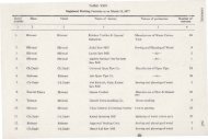
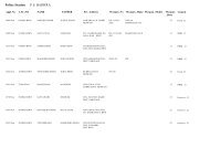
chapter-i - revenue and disaster management department, haryana
chapter-i - revenue and disaster management department, haryana
chapter-i - revenue and disaster management department, haryana

Create successful ePaper yourself
Turn your PDF publications into a flip-book with our unique Google optimized e-Paper software.
of theAravalli range st<strong>and</strong> out against the horizon. The highest ofthese is<br />
the Tosham hill, 800 feet(244 metreS)high. As<strong>and</strong>y tract stretches down the<br />
western portion ofthe district tillthe Bhiwani area is entered, wherethe district<br />
presents the appearance ofaseaof s<strong>and</strong>y billows ofamore or less fluctuating<br />
nature. The whole of the Bhiwani tahsil, leaving out a smallportion<br />
inthe east whichwasapart oftheso-called Haryana tract, was known as<br />
Bagar. Here the prevailing characteristic is a light s<strong>and</strong>y soil <strong>and</strong> shifting<br />
s<strong>and</strong>-hills interspersed in places with firmer<strong>and</strong> inpart loamy bottoms. The<br />
s<strong>and</strong>-hills are known astibbas<strong>and</strong> the firmer valleysbetween as tals. 1<br />
As regards the Loham tahsil, "The aspect ofthe country isuniform<br />
throughout the State. It presents a prospect, dreary <strong>and</strong> d~solate, a treeless<br />
waste dotted with s<strong>and</strong>-hills, <strong>and</strong> sparsely covered with vegetation. No<br />
natural divisions can be said to exista,ndthe hill system.ificomprised intWQ<br />
hills which rise in rocky isolation inthe centre ofthe State."2<br />
As regards the Dadri area, according to the Phulkian States Gazetteer<br />
(Patiala,find <strong>and</strong> Nabha), 1904,3 itlayin Haryana tract <strong>and</strong> Badhara in the<br />
Bagar which was acontinuation ofthe Bagar ofthe Bhiwani tahsil, though<br />
water was50to 54 feet(15to 16.5metres) belowthesurface.<br />
As regards the river system inthe Dadri tahsil the Phulkian States<br />
Gazetteer(Patiala,find <strong>and</strong> Nabha), 1904, records that "Tahsil Dadri, which<br />
has no canal irrigation, iswatered bythe Dohan, a stream which rises inthe<br />
l<strong>and</strong>s of Ghoghu <strong>and</strong> Bhagaur, two villages of the Jaipur State, whence it<br />
flows past the Patiala town ofKanaud <strong>and</strong> thereafter irrigates the Jind villages<br />
ofPalari, Badhwana, Jawa, Jhojhu Kalan, Balali, Abidpura, M<strong>and</strong>ola, Kaliana<br />
<strong>and</strong> Dadri for some 15 or 16miles (24 or 26 kilometres), disappearing inthe<br />
dakar l<strong>and</strong> of kalyawas (Kaliawas) in Rohtak. When in flood in the rainy<br />
season, itis used tofertilize thel<strong>and</strong>s belowitslevelfor two orthree years, but<br />
itwas apt inyears ofheavy rainfall tocause damage both to houses <strong>and</strong> crops,<br />
<strong>and</strong> is now controlled by three dams, of which the first, raised in 1874, lies<br />
between the roads leading from Dadri to Kaliana <strong>and</strong> Jhajjar, whilethe second<br />
isbetween those leading to the Dadri railway station <strong>and</strong> the Johawala tank<br />
near the town, <strong>and</strong> the third, made in 1886, adjoins Dadri station, lyingbetweenthe<br />
road leading from the town to Rawaldhi <strong>and</strong> that leading from<br />
the town to the Station. The worst floods occurred in 1862 <strong>and</strong> 1885. In<br />
the latter year considerable damage was done in the town of Dadri both to<br />
1. Ibid,pp.2,4.<br />
2. Hisar District <strong>and</strong> Loham State Gazetteer (Loharu Stq.te), 19{5. p..1.<br />
~. lhili, p. 214.