Raisby Way Railway Path and Local Nature Reserve
Raisby Way Railway Path and Local Nature Reserve
Raisby Way Railway Path and Local Nature Reserve

You also want an ePaper? Increase the reach of your titles
YUMPU automatically turns print PDFs into web optimized ePapers that Google loves.
<strong>Raisby</strong> <strong>Way</strong> <strong>Railway</strong> <strong>Path</strong><br />
<strong>and</strong> <strong>Local</strong> <strong>Nature</strong> <strong>Reserve</strong><br />
What is special?<br />
This <strong>Railway</strong> <strong>Path</strong> is bordered by mature hedgerow which provides a good habitat for birds <strong>and</strong><br />
butterflies. In total, 22 species of butterfly have been recorded along its length including the comma,<br />
clouded yellow, white letter hairstreak <strong>and</strong> dingy skipper.<br />
Scrub, an essential source of food <strong>and</strong> shelter for wildlife, borders the line but is cut back on a regular<br />
basis. This helps to maintain the balance between scrub <strong>and</strong> open areas of valuable flower-rich<br />
Magnesian Limestone grassl<strong>and</strong>. The alder <strong>and</strong> pine trees at the eastern end of the site provide food<br />
for numerous birds including siskin <strong>and</strong> red poll.<br />
A series of well-preserved lime kilns can be seen close to the western end of the line with a thick<br />
curtain of cotoneaster hanging from it. Kestrels have been sighted making their nests in the lime<br />
kilns. Peregrine falcons, sparrowhawks <strong>and</strong> stoat also hunt here.<br />
Adjacent to the <strong>Raisby</strong> <strong>Way</strong> is Trimdon Grange Quarry <strong>Local</strong> <strong>Nature</strong> <strong>Reserve</strong>. This is an ab<strong>and</strong>oned<br />
limestone quarry managed by Durham Wildlife Trust. The deserted mediaeval village of<br />
Garmondsway is to the southwest of the line. It can be accessed using Public Rights of <strong>Way</strong>.<br />
Contact the Countryside Service<br />
telephone: 03000 264 589<br />
email: countryside@durham.gov.uk<br />
www.durham.gov.uk/countryside<br />
more info...<br />
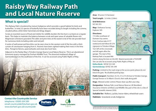
Area: 30 acres (12 hectares)<br />
Total Length: 1.6 miles (2.6km)<br />
Grid Reference:<br />
NZ 363 353<br />
Map: Ordnance Survey<br />
Explorer 305<br />
Directions:<br />
7.5 miles southeast of<br />
Durham City centre.<br />
From Coxhoe, take A177<br />
eastbound <strong>and</strong> follow B1278<br />
signposts to Trimdon Village.<br />
zoom<br />
Turn left at the crossroads<br />
in<br />
<strong>and</strong> left again after the<br />
© Crown Copyright <strong>and</strong> database right 2011 Ordnance Survey 100049055<br />
garage. The start of the<br />
<strong>Railway</strong> <strong>Path</strong> is located 900<br />
metres along the lane on the left. Nearest postcode is TS29 6NP<br />
Site can also be accessed using Public Rights of <strong>Way</strong> at:<br />
Kelloe Bank: GR NZ 353 349<br />
Garmondsway: GR NZ 345 349<br />
Parking: Limited to the road verge at the access point, please do not<br />
block the gate. No disabled parking bays<br />
Public transport: Numbers 33, 55, 213, 214 (Arriva) to Trimdon Grange,<br />
Grange Terrace or St Alban’s Church, then walk along path<br />
Dogs: Allowed under controt. Please clean up after your dog<br />
Designation: <strong>Railway</strong> <strong>Path</strong>, <strong>Local</strong> <strong>Nature</strong> <strong>Reserve</strong>, UK Woodl<strong>and</strong><br />
Assurance Scheme certified, <strong>Local</strong> Wildlife Site, part of the site is a Site of<br />
Special Scientific Interest (SSSI)<br />
Suitable for: Walkers, cyclists, horse-riders, wheelchair users<br />
Habitats: Grassl<strong>and</strong>, scrub, hedgerow<br />
Whilst every effort has been made by Durham County Council to ensure accuracy of information,<br />
the Council cannot accept any liability resulting from omissions or inaccuracies.
<strong>Raisby</strong> <strong>Way</strong> <strong>Railway</strong> <strong>Path</strong> <strong>and</strong> <strong>Local</strong> <strong>Nature</strong> <strong>Reserve</strong><br />
Accessibility Statement<br />
The path consists of bare earth with some large stones <strong>and</strong> loose materials.<br />
Some patches can get muddy <strong>and</strong> difficult to negotiate in wet conditions.<br />
The path width varies between 1.2 to 2.6 metres. Fencing at the western end<br />
restricts the path width to 55cm. The route is gently undulating <strong>and</strong> only<br />
those gradients which are particularly steep are marked.<br />
Clouded yellow<br />
Alder<br />
Stoat<br />
Comma<br />
Dingy skipper<br />
Sparrowhawk<br />
Photographs: M Murphy, S Priestley, www.wildstock.co.uk, www.northeastwildlife.co.uk<br />
Lesser redpoll<br />
Siskin<br />
back
<strong>Raisby</strong> <strong>Way</strong> <strong>Railway</strong> <strong>Path</strong> <strong>and</strong> <strong>Local</strong> <strong>Nature</strong> <strong>Reserve</strong><br />
ft<br />
500<br />
450<br />
400<br />
0 0.2 0.4 0.6 0.8 1 1.2 1.4 miles<br />
Trimdon Grange<br />
NZ 364353<br />
Cornforth<br />
Coxhoe<br />
Kelloe Bank<br />
NZ 353349<br />
Garmondsway<br />
© Crown Copyright <strong>and</strong> database right 2011. Ordnance Survey 100049055<br />
Cassop<br />
Quarrington Hill<br />
Kelloe<br />
Low <strong>Raisby</strong><br />
zoom<br />
in<br />
Garmondsway<br />
NZ 340351<br />
Trimdon<br />
Grange<br />
Trimdon<br />
Wheatley Hill<br />
Trimdon<br />
Colliery<br />
Wingate<br />
back
<strong>Raisby</strong> <strong>Way</strong> <strong>Railway</strong> <strong>Path</strong><br />
<strong>and</strong> <strong>Local</strong> <strong>Nature</strong> <strong>Reserve</strong><br />
Fence<br />
gap 65cm<br />
Site of the medieval<br />
village of<br />
Garmondsway<br />
<strong>Raisby</strong><br />
Quarries<br />
© Crown Copyright <strong>and</strong> database right 2011. Ordnance Survey 100049055<br />
Garmondsway<br />
Low <strong>Raisby</strong><br />
Kelloe Bank<br />
21m<br />
23m<br />
Trimdon Grange<br />
Quarry<br />
x2<br />
zoom<br />
out<br />
gap 1.2m<br />
N<br />
0 715m<br />
to<br />
Trimdon<br />
Grange<br />
B1278 to<br />
Trimdon<br />
KEY<br />
Seat<br />
Parking<br />
Gate<br />
Medium Slope Down1:20-1:10<br />
Steep Slope Down1:10-1:1<br />
Bus Stop<br />
Direction of Travel<br />
Hard Unsealed Surface<br />
back