RBI 02: Cordillera Azul - Espanol - The Field Museum
RBI 02: Cordillera Azul - Espanol - The Field Museum
RBI 02: Cordillera Azul - Espanol - The Field Museum

Create successful ePaper yourself
Turn your PDF publications into a flip-book with our unique Google optimized e-Paper software.
20<br />
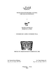
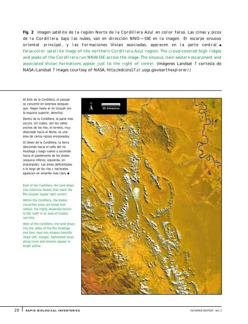
Fig. 2 Imagen satélite de la región Norte de la <strong>Cordillera</strong> <strong>Azul</strong> en color falso. Las cimas y picos<br />
de la <strong>Cordillera</strong>, bajo las nubes, van en dirección NNO—SSE en la imagen. El escarpe sinuoso<br />
oriental principal, y las formaciones Vivian asociadas, aparecen en la parte central. <br />
False-color satellite image of the northern <strong>Cordillera</strong> <strong>Azul</strong> region. <strong>The</strong> cloud-covered high ridges<br />
and peaks of the <strong>Cordillera</strong> run NNW-SSE across the image. <strong>The</strong> sinuous, main eastern escarpment and<br />
associated Vivian formations appear just to the right of center. (Imágenes Landsat 7 cortesía de<br />
NASA / Landsat 7 images courtesy of NASA, http://edcsns17.cr.usgs.gov/earthexplorer/.)<br />
Al Este de la <strong>Cordillera</strong>, el paisaje<br />
se convierte en extensos bosques<br />
que llegan hasta al río Ucayali (en<br />
la esquina superior, derecha).<br />
Dentro de la <strong>Cordillera</strong>, la parte más<br />
oscura, sin nubes, son los valles<br />
anchos de los ríos; el terreno, muy<br />
disectado hacia el Norte, es una<br />
área de cerros rojizos erosionados.<br />
Al Oeste de la <strong>Cordillera</strong>, la tierra<br />
desciende hacia el valle del río<br />
Huallaga y luego vuelve a ascender<br />
hacia el piedemonte de los Andes<br />
(esquina inferior, izquierda, en<br />
anaranjado). Las áreas deforestadas<br />
a lo largo de los ríos y riachuelos<br />
aparecen en amarillo más claro. <br />
East of the <strong>Cordillera</strong>, the land drops<br />
into extensive forests that reach the<br />
Río Ucayali (upper right corner).<br />
Within the <strong>Cordillera</strong>, the darker,<br />
cloud-free areas are broad river<br />
valleys; the highly dissected terrain<br />
to the north is an area of eroded,<br />
red hills.<br />
West of the <strong>Cordillera</strong>, the land drops<br />
into the valley of the Río Huallaga<br />
and then rises into Andean foothills<br />
(lower left, orange). Deforested areas<br />
along rivers and streams appear in<br />
bright yellow.<br />
<br />
20 kilómetros<br />
RAPID BIOLOGICAL INVENTORIES INFORME/REPORT NO.2