Shoreline Management Glossary - Center for Coastal Resources ...
Shoreline Management Glossary - Center for Coastal Resources ...
Shoreline Management Glossary - Center for Coastal Resources ...

Create successful ePaper yourself
Turn your PDF publications into a flip-book with our unique Google optimized e-Paper software.
Last revised: 10/2006 1<br />
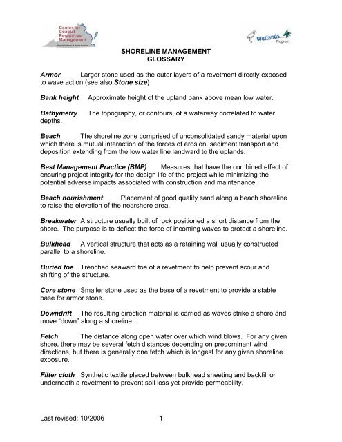
SHORELINE MANAGEMENT<br />
GLOSSARY<br />
Armor Larger stone used as the outer layers of a revetment directly exposed<br />
to wave action (see also Stone size)<br />
Bank height Approximate height of the upland bank above mean low water.<br />
Bathymetry The topography, or contours, of a waterway correlated to water<br />
depths.<br />
Beach The shoreline zone comprised of unconsolidated sandy material upon<br />
which there is mutual interaction of the <strong>for</strong>ces of erosion, sediment transport and<br />
deposition extending from the low water line landward to the uplands.<br />
Best <strong>Management</strong> Practice (BMP) Measures that have the combined effect of<br />
ensuring project integrity <strong>for</strong> the design life of the project while minimizing the<br />
potential adverse impacts associated with construction and maintenance.<br />
Beach nourishment Placement of good quality sand along a beach shoreline<br />
to raise the elevation of the nearshore area.<br />
Breakwater A structure usually built of rock positioned a short distance from the<br />
shore. The purpose is to deflect the <strong>for</strong>ce of incoming waves to protect a shoreline.<br />
Bulkhead A vertical structure that acts as a retaining wall usually constructed<br />
parallel to a shoreline.<br />
Buried toe Trenched seaward toe of a revetment to help prevent scour and<br />
shifting of the structure.<br />
Core stone Smaller stone used as the base of a revetment to provide a stable<br />
base <strong>for</strong> armor stone.<br />
Downdrift The resulting direction material is carried as waves strike a shore and<br />
move “down” along a shoreline.<br />
Fetch The distance along open water over which wind blows. For any given<br />
shore, there may be several fetch distances depending on predominant wind<br />
directions, but there is generally one fetch which is longest <strong>for</strong> any given shoreline<br />
exposure.<br />
Filter cloth Synthetic textile placed between bulkhead sheeting and backfill or<br />
underneath a revetment to prevent soil loss yet provide permeability.
Gabion A basket or cage filled with stone, brick or other material to give it a<br />
weight suitable <strong>for</strong> use in revetments or breakwaters. In the marine environment,<br />
usually made with galvanized steel wire mesh with a PVC coating.<br />
Groin A rigid, vertical structure extending perpendicular to shore to trap<br />
transporting sand or other material down a shoreline.<br />
Groin field A series of several groins built parallel to each other along a shoreline.<br />
Headland A point of land jutting out into a body of water or a shoreline section<br />
less resistant to erosion process than adjacent shorelines.<br />
Jetty A structure similar to a groin, but typically designed to prevent shoaling<br />
of a navigation channel.<br />
Joint Permit Application or JPA The standard Joint Permit Application <strong>for</strong><br />
shoreline stabilization structures and other activities conducted in wetlands and the<br />
marine environment. The applicant completes one <strong>for</strong>m and submits to either local<br />
agency or VMRC, which is responsible <strong>for</strong> distributing to local, state and federal<br />
permitting and advisory agencies (e.g. VIMS, Game & Inland Fisheries, Dept. of<br />
Conservation & Recreation, Dept. of Environmental Quality, US Army Corps of<br />
Engineers).<br />
Incidental effects Indirect impacts of an activity or structure, such as those<br />
resulting from redirected wave energy, trapped sand or sedimentation.<br />
Littoral transport The movement of sand and other materials along the shoreline<br />
in the littoral zone, or the area between high and low watermarks during non-storm<br />
periods.<br />
Living <strong>Shoreline</strong> Treatment A shoreline management practice that addresses<br />
erosion by providing <strong>for</strong> long-term protection, restoration or enhancement of<br />
vegetated shoreline habitats. This is accomplished through the strategic placement<br />
of plants, stone, sand fill and other structural and organic materials. Living <strong>Shoreline</strong><br />
treatments do not include structures that sever natural connections between riparian,<br />
intertidal and aquatic areas.<br />
Low profile The recommended design <strong>for</strong> groins with a channelward<br />
elevation no greater than mean low water to allow sand bypass to continue once the<br />
groin cell is filled, reducing the potential <strong>for</strong> adverse downdrift effects.<br />
Marsh fringe A band of marsh plants which runs parallel to a shoreline.<br />
Marsh toe revetment A low revetment built to protect an eroding marsh<br />
shoreline.<br />
<strong>Shoreline</strong> <strong>Management</strong> <strong>Glossary</strong> p. 2
Mean high water The average height of high waters over a nineteen year period.<br />
Mean low water The average height of low waters over a nineteen year period.<br />
Virginia is a low water state, meaning private property extends to the mean low<br />
water line.<br />
Mean tide range The vertical distance between mean high water and mean low<br />
water.<br />
Nearshore A term referring to the area close to the shore but still partly<br />
submerged. This area is where sand bars and shoals often <strong>for</strong>m.<br />
Pressure treated The process of preserving wood by impregnating it with<br />
chemicals to reduce or retard invasion by wood destroying organisms.<br />
Reach A discrete portion of a shoreline somewhat homogeneous in its<br />
physical characteristics and upon which there are mutual interaction of the <strong>for</strong>ces of<br />
erosion, sediment transport, and accretion.<br />
Return walls Bulkhead end sections perpendicular to the shoreline to tie the<br />
bulkhead into the upland and prevent the bulkhead from being flanked as the<br />
shoreline continues to retreat on either side of the structure.<br />
Revetment A sloped structure constructed with large, heavy stone, often in two<br />
layers, used to anchor the base of the upland bank. The size of a revetment is<br />
dictated by the energy of the shoreline environment where it is proposed.<br />
Riprap Stone that is hard and angular that will not disintegrate from<br />
exposure to water or weathering.<br />
Scarp A low steep slope caused by wave erosion.<br />
Seawall A vertical wall or embankment, usually taller and larger than a<br />
bulkhead.<br />
Shoal A shallow area in a waterway, often created by nearby sandbars or<br />
sandbanks.<br />
Shore orientation The compass direction the shoreline faces. Some directions are<br />
more prone than others to the erosive <strong>for</strong>ces of storm events.<br />
Sill An erosion protection measure that combines elements of both revetments<br />
and offshore breakwaters. Sills are usually built of stone, low in profile and built<br />
close to shore.<br />
<strong>Shoreline</strong> <strong>Management</strong> <strong>Glossary</strong> p. 3
Sediment barrier or Silt screen Structures placed at the toe of a slope or in a<br />
drainageway to intercept and detain sediment and decrease flow velocities. Barriers<br />
may be constructed of posts and filter fabric properly anchored at the base or hay<br />
bales staked in place end to end.<br />
Sheet pile A wooden plank or steel sheet used in the construction of bulkheads<br />
and groins.<br />
Slope Degree of deviation of a surface from the horizontal; measured as a<br />
numeric ratio, percent or in degrees. When expressed as ratio, the first number is<br />
the horizontal distance and the second is the vertical distance.<br />
Splash apron A structural component, often of rock, used to prevent <strong>for</strong>ceful<br />
waves from scouring out material from the top of a revetment or bulkhead.<br />
Spur A vertical structure normally used perpendicular to groins to redirect<br />
incoming waves to allow a sheltered area in the lee and promote the accumulation of<br />
sand.<br />
Stone size classes of riprap stone based on weight per VDOT specifications<br />
Class A1 25-75 pounds, < 10% weighing more than 75 lbs, “man-sized”<br />
Class 1 50-150 pounds, 60% weighing more than 100 lbs<br />
Class 2 150-500 pounds, 50% weighing more than 300 lbs<br />
Class 3 500-1,500 pounds, 50% weighing more than 900 lbs<br />
Type 1 1,500-4,000 pounds, average weight 2,000 lbs<br />
Type 2 6,000 – 20,000 pounds, average weight 8,000 lbs<br />
Storm surge The resulting temporary rise in sea level due to large waves and<br />
low atmospheric pressure created during storms.<br />
Subaqueous or Submerged lands The ungranted lands beneath the tidal<br />
waters of the Commonwealth extending seaward from the mean low water mark to<br />
the 3 mile limit.<br />
Submerged aquatic vegetation (SAV) Rooted plants found in shoal areas of<br />
Chesapeake Bay which provide important ecological roles, such as providing food,<br />
shelter and oxygen as well as trap sediment and dissipate wave energy.<br />
Time of year restrictions Restrictions that limit construction projects during periods<br />
of heightened sensitivity <strong>for</strong> species of concern, such as anadromous fish, nesting<br />
shorebirds, shellfish, submerged aquatic vegetation (SAV), and threatened and<br />
endangered species, such as the bald eagle and northeastern beach tiger beetle.<br />
Tombolo The area of accumulated beach material in the lee of a breakwater<br />
structure.<br />
<strong>Shoreline</strong> <strong>Management</strong> <strong>Glossary</strong> p. 4
Wave climate The average wave conditions as they impact a shoreline,<br />
including waves, fetch, dominant seasonal winds and bathymetry.<br />
Wave energy The <strong>for</strong>ce a wave is likely to have on a shoreline depending on<br />
environmental factors, such as shore orientation, wind, channel width, and<br />
bathymetry.<br />
Wave height The vertical measurement of a single wave from its base or<br />
trough to its top or crest.<br />
Sources:<br />
VMRC 1999. <strong>Shoreline</strong> Development BMP’s: Best <strong>Management</strong> Practices <strong>for</strong><br />
<strong>Shoreline</strong> Development Activities which encroach in, on, or over Virginia’s tidal<br />
wetlands, coastal primary sand dunes and beaches, and submerged lands. Virginia<br />
Marine <strong>Resources</strong> Commission, August 1999.<br />
Hardaway, C. S. and R. J. Byrne. 1999. <strong>Shoreline</strong> <strong>Management</strong> in Chesapeake<br />
Bay. Virginia Sea Grant Publication VSG-99-11.<br />
Virginia Wetlands <strong>Management</strong> Handbook -<br />
http://ccrm.vims.edu/wetlands/handbook<br />
Wetlands Self-Taught Education Units - http://ccrm.vims.edu/wetlands/selfeds<br />
Wetland Functions & Values<br />
<strong>Coastal</strong> <strong>Shoreline</strong> Defense Structures<br />
<strong>Shoreline</strong> <strong>Management</strong> <strong>Glossary</strong> p. 5