PLIENSBACHIAN (LOWER JURASSIC) BIOSTRATIGRAPHY AND ...
PLIENSBACHIAN (LOWER JURASSIC) BIOSTRATIGRAPHY AND ...
PLIENSBACHIAN (LOWER JURASSIC) BIOSTRATIGRAPHY AND ...

You also want an ePaper? Increase the reach of your titles
YUMPU automatically turns print PDFs into web optimized ePapers that Google loves.
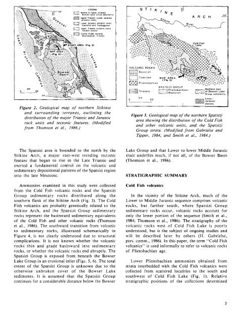
Figure 2. Geological m ap o f northern Stikinia<br />
a n d su rro u n d in g terra n es, o u tlin in g th e<br />
distribution o f the m ajor Triassic and Jurassic<br />
rock units and tectonic features. (M odified<br />
fro m Thom son et al., 1986.)<br />
The Spatsizi area is bounded to the north by the<br />
Stikine Arch, a major east-west trending tectonic<br />
feature that began to rise in the Late Triassic and<br />
exerted a fundamental control on the volcanic and<br />
sedimentary depositional patterns of the Spatsizi region<br />
into the late Mesozoic.<br />
Ammonites examined in this study were collected<br />
from the Cold Fish volcanic rocks and the Spatsizi<br />
Group sedimentary rocks distributed along the<br />
southern flank of the Stikine Arch (Fig. 3). The Cold<br />
Fish volcanics are probably genetically related to the<br />
Stikine Arch, and the Spatsizi Group sedimentary<br />
rocks represent the basinward sedimentary equivalents<br />
of the Cold Fish and other volcanic rocks (Thomson<br />
et al., 1986). The southward transition from volcanic<br />
to sedimentary rocks, illustrated schematically in<br />
Figure 4, is not clearly understood due to structural<br />
complications. It is not known whether the volcanic<br />
rocks thin and grade basinward into sedimentary<br />
rocks, or whether the volcanic rocks end abruptly. The<br />
Spatsizi Group is exposed from beneath the Bowser<br />
Lake Group in an erosional inlier (Figs. 5, 6). The total<br />
extent of the Spatsizi Group is unknown due to the<br />
otherwise unbroken cover of the Bowser Lake<br />
sediments. It is assumed that the Spatsizi Group<br />
continues for a considerable distance below the Bowser<br />
Figure 3. Geological m ap o f the northern Spatsizi<br />
area showing the distribution o f the Cold Fish<br />
a nd other volcanic units, and the Spatsizi<br />
G roup strata. (M odified fro m Gabrielse and<br />
Tipper, 1984, and Sm ith et al., 1984.)<br />
Lake Group and that Lower to lower Middle Jurassic<br />
shale underlies much, if not all, of the Bowser Basin<br />
(Thomson et al., 1986).<br />
STRATIGRAPHIC SUMMARY<br />
Cold Fish volcanics<br />
In the vicinity of the Stikine Arch, much of the<br />
Lower to Middle Jurassic sequence comprises volcanic<br />
rocks, but farther south, where Spatsizi Group<br />
sedimentary rocks occur, volcanic rocks account for<br />
only the lower portion of the sequence (Smith et al.,<br />
1984; Thomson et al., 1986). The stratigraphy of the<br />
volcanic rocks west of Cold Fish Lake is poorly<br />
understood, but is the subject of ongoing studies and<br />
will be described later by others (H. Gabrielse,<br />
pers. comm., 1986). In this paper, the term “ Cold Fish<br />
volcanics” is used informally to refer to volcanic rocks<br />
of Pliensbachian age.<br />
Lower Pliensbachian ammonites obtained from<br />
strata interbedded with the Cold Fish volcanics were<br />
collected from scattered localities to the south and<br />
southwest of Cold Fish Lake (Fig. 1). Relative<br />
stratigraphic positions of the collections determined