Arecibo Radar Mapping of the Lunar Poles: A Search for Ice Deposits
Arecibo Radar Mapping of the Lunar Poles: A Search for Ice Deposits
Arecibo Radar Mapping of the Lunar Poles: A Search for Ice Deposits

Create successful ePaper yourself
Turn your PDF publications into a flip-book with our unique Google optimized e-Paper software.
REPORTS<br />
<strong>Arecibo</strong> <strong>Radar</strong> <strong>Mapping</strong> <strong>of</strong> <strong>the</strong> <strong>Lunar</strong> <strong>Poles</strong>:<br />
A <strong>Search</strong> <strong>for</strong> <strong>Ice</strong> <strong>Deposits</strong><br />
N. J. S. Stacy, D. B. Campbell,* P. G. Ford<br />
The <strong>Arecibo</strong> 12.6-centimeter wavelength radar system was used to image <strong>the</strong> polar<br />
regions <strong>of</strong> <strong>the</strong> moon at a resolution <strong>of</strong> 125 meters in a search <strong>for</strong> ice deposits in areas<br />
<strong>of</strong> possible permanent shadow from <strong>the</strong> sun. No areas greater than 1 square kilometer<br />
were found with high radar backscatter cross sections and high circular polarization<br />
ratios, properties suggestive <strong>of</strong> <strong>the</strong> presence <strong>of</strong> ice. A number <strong>of</strong> areas smaller than 1<br />
square kilometer were found with <strong>the</strong>se properties, but optical images from spacecraft<br />
missions have shown some <strong>of</strong> <strong>the</strong>se features to be in sunlight. <strong>Arecibo</strong> radar images <strong>of</strong><br />
Sinus Iridum at latitude 47°N also showed a number <strong>of</strong> small features with similar<br />
properties. The coincidence <strong>of</strong> some <strong>of</strong> <strong>the</strong>se features with <strong>the</strong> radar-facing slopes <strong>of</strong><br />
craters and <strong>the</strong>ir presence in sunlit areas suggests that very rough surfaces ra<strong>the</strong>r than<br />
ice deposits are responsible <strong>for</strong> <strong>the</strong>ir unusual radar properties.<br />
Ground-based observations <strong>of</strong> <strong>the</strong> moon<br />
were conducted using <strong>the</strong> <strong>Arecibo</strong> Observatory,<br />
Puerto Rico, 2.38-GHz (12.6-cm<br />
wavelength) radar system to map regions <strong>of</strong><br />
lunar surface radio-wave backscatter in two<br />
polarizations at high spatial resolution (1).<br />
Observations <strong>of</strong> <strong>the</strong> polar regions were fur<strong>the</strong>r<br />
motivated by <strong>the</strong> ability <strong>of</strong> radar to<br />
image areas not illuminated by sunlight;<br />
such areas may provide an environment<br />
suitable <strong>for</strong> <strong>the</strong> preservation <strong>of</strong> ice deposits<br />
or o<strong>the</strong>r volatiles over geologic time scales<br />
(2). Here, we present ground-based radar<br />
images <strong>of</strong> <strong>the</strong> north and south lunar poles<br />
and analyze <strong>the</strong> polarization properties <strong>of</strong><br />
<strong>the</strong> reflected signal in <strong>the</strong> context <strong>of</strong> <strong>the</strong><br />
possible presence <strong>of</strong> ice.<br />
It has been suggested that permanently<br />
shadowed regions <strong>of</strong> <strong>the</strong> lunar poles would<br />
have relatively constant surface and subsurface<br />
temperatures, possibly as low as 40 K,<br />
providing an environment suitable <strong>for</strong> <strong>the</strong><br />
entrapment and storage <strong>of</strong> ices over geologic<br />
time scales (2). The discovery <strong>of</strong> anomalous<br />
radar backscatter from permanently<br />
shadowed crater floors near <strong>the</strong> poles <strong>of</strong><br />
Mercury and <strong>the</strong> interpretation <strong>of</strong> <strong>the</strong>se<br />
regions as areas <strong>of</strong> probable water ice deposits<br />
(3, 4) streng<strong>the</strong>ned <strong>the</strong> possibility <strong>of</strong><br />
finding similar deposits near <strong>the</strong> lunar<br />
poles. The interpretation that ice is responsible<br />
<strong>for</strong> <strong>the</strong> anomalous radar backscatter in<br />
<strong>the</strong> Mercury radar images rests primarily on<br />
<strong>the</strong> unusual radar backscatter characteristics<br />
<strong>of</strong> many icy surfaces in <strong>the</strong> solar system—that<br />
is, high backscatter cross section<br />
N. J. S. Stacy, Microwave <strong>Radar</strong> Division, Building 180L,<br />
Defence Science and Technology Organization, Post Office<br />
Box 1500, Salisbury, SA 5108, Australia.<br />
D. B. Campbell, National Astronomy and Ionosphere<br />
Center and Department <strong>of</strong> Astronomy, Space Sciences<br />
Building, Cornell University, Ithaca, NY 14853, USA.<br />
P. G. Ford, Center <strong>for</strong> Space Research, Massachusetts<br />
Institute <strong>of</strong> Technology, Cambridge, MA 02139, USA.<br />
*To whom correspondence should be addressed. E-mail:<br />
campbell@astrosun.tn.cornell.edu<br />
per unit surface area ( o ) with a circular<br />
polarization ratio (CPR) greater than unity<br />
(5). Although ice, with a dielectric constant<br />
<strong>of</strong> 3.15, does not have an intrinsically<br />
high reflectivity, it has low loss and thus<br />
may serve as a weakly absorbing material<br />
containing a matrix <strong>of</strong> embedded scatterers;<br />
such a material could support volume-scattering<br />
mechanisms such as <strong>the</strong> coherent<br />
backscatter opposition effect (6). Recent<br />
bistatic radar observations <strong>of</strong> <strong>the</strong> lunar<br />
south pole by <strong>the</strong> Clementine spacecraft are<br />
reported to show a backscatter enhancement<br />
consistent with, but not unique to,<br />
<strong>the</strong> presence <strong>of</strong> ice deposits (7). In comparison,<br />
<strong>the</strong> backscatter characteristics <strong>of</strong> rock<br />
surfaces that are rough on <strong>the</strong> scale <strong>of</strong> <strong>the</strong><br />
radar wavelength (such as lava flows) and<br />
are observed at high incidence angles generally<br />
include high backscatter cross sections<br />
and CPRs <strong>of</strong> 1 (8). However, CPRs<br />
greater than unity have been observed over<br />
rock surfaces. Areas <strong>of</strong> <strong>the</strong> blocky SP lava<br />
flow in nor<strong>the</strong>rn Arizona observed at incidence<br />
angles <strong>of</strong> 42° to 52° have CPRs between<br />
1 and 2.5 (9).<br />
As viewed from <strong>the</strong> lunar poles, <strong>the</strong><br />
<strong>Arecibo</strong> Observatory rises a maximum <strong>of</strong><br />
6° above <strong>the</strong> horizon [incidence angle <strong>of</strong><br />
84° (10)], but, given <strong>the</strong> 1.53° inclination<br />
<strong>of</strong> <strong>the</strong> moon’s equatorial plane to <strong>the</strong> ecliptic<br />
plane, <strong>the</strong> limb <strong>of</strong> <strong>the</strong> sun can be up to<br />
1.82° above <strong>the</strong> horizon. Because we lack<br />
detailed knowledge <strong>of</strong> <strong>the</strong> lunar topography,<br />
<strong>the</strong>se small angles mean that an unknown<br />
fraction <strong>of</strong> <strong>the</strong> area shadowed from <strong>the</strong> sun<br />
is also shadowed from <strong>Arecibo</strong> and, hence,<br />
is not observable (<strong>for</strong> example, <strong>the</strong> floors <strong>of</strong><br />
<strong>the</strong> large impact craters). At <strong>the</strong> lunar south<br />
pole, about 60% <strong>of</strong> <strong>the</strong> area below latitude<br />
85°S is observed in <strong>the</strong> radar image, including<br />
much <strong>of</strong> <strong>the</strong> south pole area shown to be<br />
in solar shadow in <strong>Lunar</strong> Orbiter IV (11)<br />
and Clementine optical images (7, 12).<br />
However, areas shadowed in <strong>the</strong>se space-<br />
www.sciencemag.org SCIENCE VOL. 276 <br />
craft optical images are not necessarily in<br />
permanent shadow because <strong>of</strong> <strong>the</strong> 18.6-year<br />
precessional period <strong>of</strong> <strong>the</strong> lunar spin axis.<br />
The lack <strong>of</strong> detailed topographic in<strong>for</strong>mation<br />
<strong>for</strong> <strong>the</strong> polar regions makes it impossible<br />
to determine which areas are in permanent<br />
shadow.<br />
<strong>Radar</strong> images <strong>of</strong> <strong>the</strong> north and south<br />
polar regions <strong>of</strong> <strong>the</strong> moon were acquired in<br />
May and August 1992, respectively (1). A<br />
circularly polarized wave was transmitted<br />
from <strong>the</strong> main <strong>Arecibo</strong> antenna, and both<br />
senses <strong>of</strong> circular polarization—opposite<br />
circular (OC) and same circular (SC)<br />
(13)—were received at a smaller auxiliary<br />
antenna located 11 km from <strong>the</strong> <strong>Arecibo</strong><br />
telescope. This bistatic radar arrangement<br />
permitted a pulsed radar experiment that<br />
avoided ambiguities in range (range aliasing)<br />
while maintaining an average data rate<br />
appropriate <strong>for</strong> <strong>the</strong> data acquisition hardware<br />
(14). The transmit signal was encoded<br />
with a pseudorandom code, and 16,384<br />
pulses acquired in 25 min were combined<br />
to <strong>for</strong>m a range-Doppler image with a resolution<br />
<strong>of</strong> 125 m and three or four looks<br />
(independent measurements <strong>of</strong> <strong>the</strong> backscatter<br />
from a given surface area). The final<br />
processing stage resampled <strong>the</strong> range-Doppler<br />
image into selenographic coordinates<br />
and applied small <strong>of</strong>fsets to align <strong>the</strong> position<br />
<strong>of</strong> <strong>the</strong> poles with published locations<br />
(11).<br />
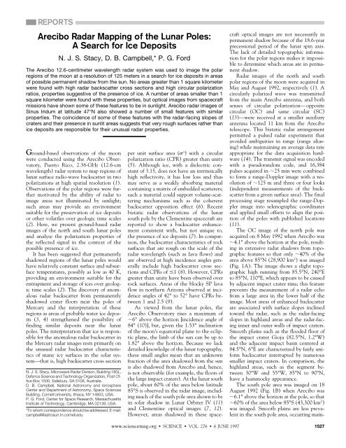
The OC image <strong>of</strong> <strong>the</strong> north pole was<br />
acquired on 8 May 1992 when <strong>Arecibo</strong> was<br />
4.1° above <strong>the</strong> horizon at <strong>the</strong> pole, resulting<br />
in extensive radar shadows from topographic<br />
features so that only 40% <strong>of</strong> <strong>the</strong><br />
area above 85°N (28,900 km 2 ) was imaged<br />
(Fig. 1A). The image shows a slight topographic<br />
high running from 85.5°N, 240°E<br />
to 85°N, 110°E, which appears to be caused<br />
by adjacent impact crater rims; this feature<br />
prevents <strong>the</strong> measurement <strong>of</strong> a radar echo<br />
from a large area in <strong>the</strong> lower half <strong>of</strong> <strong>the</strong><br />
image. Most areas <strong>of</strong> enhanced backscatter<br />
are associated with surface slopes inclined<br />
toward <strong>the</strong> radar, such as <strong>the</strong> radar-facing<br />
slopes in highland areas and <strong>the</strong> radar-facing<br />
inner and outer walls <strong>of</strong> impact craters.<br />
Smooth plains such as <strong>the</strong> flooded floor <strong>of</strong><br />
<strong>the</strong> impact crater Gioja (82.5°N, 1.2°W)<br />
and <strong>the</strong> adjacent impact basin centered at<br />
84.5°N, 6°E are characterized by fairly uni<strong>for</strong>m<br />
backscatter interrupted by numerous<br />
smaller impact craters. In comparison, <strong>the</strong><br />
highland areas, such as <strong>the</strong> segment between<br />
30°W and 55°W, 85°N to 90°N,<br />
have a hummocky appearance.<br />
The south pole area was imaged on 18<br />
August 1992 (Fig. 1B) when <strong>Arecibo</strong> was<br />
6.1° above <strong>the</strong> horizon at <strong>the</strong> pole, so that<br />
60% <strong>of</strong> <strong>the</strong> area below 85°S (43,300 km 2 )<br />
was imaged. Smooth plains are less prevalent<br />
in <strong>the</strong> south pole area, occurring main-<br />
6 JUNE 1997 1527
ly in <strong>the</strong> floor <strong>of</strong> <strong>the</strong> crater Amundsen at<br />
84.7°S, 82.2°E, in <strong>the</strong> area to <strong>the</strong> east <strong>of</strong><br />
Amundsen around 85.7°S, 127.7°E, and in<br />
<strong>the</strong> region around 86.5°S, 75°W, which<br />
appears to be <strong>the</strong> floor <strong>of</strong> an impact feature<br />
centered at 85.5°S, 90°W in <strong>the</strong> Clementine<br />
optical image (7, 12).<br />
The CPR images <strong>for</strong> <strong>the</strong> north and south<br />
pole regions have very similar characteristics.<br />
There are no extensive areas with<br />
CPRs approaching or greater than unity.<br />
The average CPRs <strong>for</strong> areas that appear to<br />
have little topographic expression (and are<br />
not in <strong>the</strong> radar shadow) are 0.45 <strong>for</strong> <strong>the</strong><br />
north pole and 0.37 <strong>for</strong> <strong>the</strong> south pole. If<br />
large craters and complex areas are included<br />
in <strong>the</strong>se measurements, <strong>the</strong>n <strong>the</strong> CPRs in-<br />
A<br />
90°<br />
0°<br />
180°<br />
80°N<br />
270°<br />
crease to 0.54 and 0.45, respectively. These<br />
latter values are comparable to <strong>the</strong> ratio <strong>of</strong><br />
0.54 estimated from previous scattering law<br />
measurements <strong>for</strong> <strong>the</strong> average lunar surface<br />
at high incidence angles at 23-cm wavelength<br />
(15). The images <strong>of</strong> both poles show<br />
areas <strong>of</strong> high CPR associated with <strong>the</strong> radar-bright<br />
inner walls <strong>of</strong> several craters with<br />
rim diameters <strong>of</strong> 30 km as well as smaller<br />
radar-bright features, most <strong>of</strong> which appear<br />
to be associated with small craters. For <strong>the</strong>se<br />
features, high SC backscatter cross sections<br />
correlate with <strong>the</strong> high CPRs, as shown in<br />
Fig. 2 <strong>for</strong> <strong>the</strong> south pole. For example, <strong>the</strong><br />
large impact craters labeled A and B have<br />
radar-bright, radar-facing rims with CPRs<br />
near unity, whereas craters C and D have<br />
-50 0 0 25 50 75 100<br />
σ km<br />
o Fig. 1. OC backscatter image <strong>of</strong> (A) north pole and (B) south<br />
pole regions in a stereographic map projection. The radar signal<br />
(dB)<br />
incidence angle (10) is 85.9° at <strong>the</strong> north pole and 83.9° at <strong>the</strong><br />
south pole (4.1° and 6.1° above <strong>the</strong> local horizon, respectively). The incidence angle varies in proportion<br />
to latitude along approximately <strong>the</strong> 0° to 180° longitude line in <strong>the</strong>se maps. The processed radar data<br />
were averaged to three looks with a resolution <strong>of</strong> 121 m in slant range (image top to bottom) <strong>for</strong> both<br />
images, 136 m in cross range (image left to right) <strong>for</strong> <strong>the</strong> north pole and 108 m in cross range <strong>for</strong> <strong>the</strong><br />
south pole, be<strong>for</strong>e resampling to selenographic coordinates. The radar backscatter is shown in units <strong>of</strong><br />
o , in a logarithmic scale with an absolute error <strong>of</strong> 3 dB (a factor <strong>of</strong> 2) (19). The sides <strong>of</strong> <strong>the</strong> south pole<br />
map show ghost images that were located at Doppler <strong>of</strong>fsets beyond <strong>the</strong> radar sampling frequency<br />
(pulse repetition frequency) and were aliased into <strong>the</strong> processed Doppler bandwidth.<br />
A<br />
0° 87.5°S<br />
180°<br />
40-50 - -30 -20<br />
σ<br />
-10 0 0 10 20 30<br />
km<br />
40 50<br />
o Fig. 2. Images <strong>of</strong> (A) <strong>the</strong> SC polarization<br />
backscatter and (B) <strong>the</strong><br />
CPR <strong>of</strong> <strong>the</strong> south pole region. The<br />
SC image has three looks, and<br />
B<br />
D<br />
<strong>the</strong> ratio image was calculated<br />
from data averaged to 1-km resolution<br />
and 230 looks using a<br />
boxcar filter, masked by <strong>the</strong> re- 270°<br />
C<br />
E<br />
A<br />
90°<br />
gions <strong>of</strong> radar shadow. Small radar-bright<br />
features with CPRs<br />
greater than unity are indicated<br />
by arrows. One <strong>of</strong> <strong>the</strong>se features<br />
F<br />
with extreme backscatter values<br />
is <strong>the</strong> 840-m-diameter impact<br />
crater at 88.4°N, 110°E, labeled<br />
F. The single-look image with a<br />
resolution <strong>of</strong> 121 m in range by<br />
36 m in cross range (inset in A)<br />
(dB)<br />
shows that <strong>the</strong> radar-bright area is associated with <strong>the</strong> crater rim.<br />
1528<br />
B<br />
90°<br />
0°<br />
180°<br />
80°S<br />
270°<br />
SCIENCE VOL. 276 6 JUNE 1997 www.sciencemag.org<br />
B<br />
less bright radar-facing rims with CPRs<br />
closer to <strong>the</strong> mean value. The relatively flat<br />
region around location E has a uni<strong>for</strong>m<br />
CPR <strong>of</strong> 0.4. Backscatter values <strong>for</strong> <strong>the</strong> middle<br />
area <strong>of</strong> <strong>the</strong> radar-facing inner rim <strong>of</strong> <strong>the</strong><br />
20.5-km-diameter crater A, <strong>the</strong> south pole<br />
o crater (oc 0.036, CPR 0.94 0.04),<br />
are greater than <strong>the</strong> values <strong>for</strong> <strong>the</strong> left side<br />
(in <strong>the</strong> image) <strong>of</strong> <strong>the</strong> radar-facing inner rim<br />
o <strong>of</strong> crater C (oc 0.001, CPR 0.38 <br />
0.02). The top <strong>of</strong> <strong>the</strong> rim <strong>of</strong> crater A is<br />
illuminated by sunlight in <strong>the</strong> <strong>Lunar</strong> Orbiter<br />
IV and Clementine images (7, 11, 12),<br />
indicating that it is not in permanent shadow,<br />
which suggests that <strong>the</strong> presence <strong>of</strong> ice<br />
is not a viable explanation <strong>for</strong> <strong>the</strong> enhanced<br />
backscatter. Geometric effects such as double<br />
bounce may be responsible but hi<strong>the</strong>rto<br />
have been clearly observed only when <strong>the</strong><br />
surface geometry supports <strong>for</strong>ward scatter<br />
into a second surface (1, 16). The most<br />
probable explanation is enhanced backscatter<br />
from increased wavelength-scale surface<br />
roughness in <strong>the</strong> rims <strong>of</strong> craters A and B.<br />
The enhanced backscatter areas are associated<br />
with steeper slopes; estimates <strong>of</strong> <strong>the</strong><br />
inner rim slopes from <strong>the</strong> crater radar shadow<br />
are 37° above <strong>the</strong> horizontal <strong>for</strong> crater A<br />
and 20° <strong>for</strong> crater C.<br />
Similar increases in <strong>the</strong> backscatter cross<br />
section and CPR <strong>for</strong> <strong>the</strong> radar-facing inner<br />
slopes <strong>of</strong> craters were measured in clearly<br />
sunlit areas <strong>of</strong> <strong>the</strong> moon away from <strong>the</strong><br />
poles. Figure 3 shows <strong>the</strong> SC and CPR<br />
images <strong>for</strong> Sinus Iridum and <strong>the</strong> hummocky<br />
terrain to <strong>the</strong> northwest (centered on<br />
47.2°N, 32.5°W). The two craters in <strong>the</strong><br />
lower left <strong>of</strong> <strong>the</strong> images, with diameters <strong>of</strong><br />
10 km, have CPRs in <strong>the</strong> range <strong>of</strong> 0.72 to<br />
0.94 <strong>for</strong> several areas on <strong>the</strong> radar-facing<br />
rims. Histograms <strong>of</strong> <strong>the</strong> entire CPR images<br />
in Figs. 2B and 3B have similar mean values<br />
<strong>of</strong> 0.48 and 0.49, respectively, and <strong>the</strong> high<br />
CPR tails <strong>of</strong> both distributions extend past<br />
a CPR <strong>of</strong> 1.<br />
A more puzzling problem than <strong>the</strong> near-<br />
0° 87.5°S<br />
270° 90°<br />
180°<br />
0 0.3 0.6 0.9 2 >1. 0 10 20 30 40 50<br />
CPR<br />
km
unity CPRs <strong>for</strong> <strong>the</strong> slopes <strong>of</strong> some <strong>of</strong> <strong>the</strong><br />
larger craters is <strong>the</strong> problem <strong>of</strong> CPRs greater<br />
than unity <strong>for</strong> (i) a number <strong>of</strong> craters with<br />
diameters <strong>of</strong> 1 km, (ii) small features that<br />
are probably craters with sizes near or below<br />
<strong>the</strong> image resolution, and (iii) regions <strong>of</strong> 1<br />
km 2 on <strong>the</strong> radar-facing slopes <strong>of</strong> some <strong>of</strong><br />
<strong>the</strong> larger craters. Twenty-six <strong>of</strong> <strong>the</strong> <strong>the</strong>se<br />
features were identified in <strong>the</strong> region <strong>of</strong> <strong>the</strong><br />
south pole shown in Fig. 2. The CPRs <strong>for</strong><br />
<strong>the</strong>se features varied from 1.2, a lower<br />
limit set by a selection requirement that <strong>the</strong><br />
average CPR be 2 standard deviations<br />
above unity, to 2.6 (17, 18). Their SC<br />
backscatter cross sections varied from 0.022<br />
to 0.002. If <strong>the</strong> same expression as in Harmon<br />
et al. (4) is used to correct <strong>for</strong> <strong>the</strong><br />
incidence angle, <strong>the</strong>se cross sections correspond<br />
to full-disk albedos in <strong>the</strong> range 0.7<br />
to 0.06, with half <strong>the</strong> features having a<br />
value close to 0.1. This range is similar to<br />
that obtained by Harmon et al. <strong>for</strong> <strong>the</strong><br />
possible polar ice deposits on Mercury, although<br />
<strong>the</strong> median value is somewhat lower<br />
and <strong>the</strong> sizes <strong>of</strong> <strong>the</strong> regions are much smaller<br />
than those found on Mercury. However,<br />
examination <strong>of</strong> a mosaic <strong>of</strong> <strong>the</strong> south pole<br />
region made from Clementine images (12)<br />
indicates that at least 9 <strong>of</strong> <strong>the</strong> 26 features,<br />
primarily those in <strong>the</strong> smooth plains area to<br />
<strong>the</strong> left <strong>of</strong> crater C in Fig. 2 (near 86.5°S,<br />
75°W), are in sunlit areas. This estimate is<br />
probably low because <strong>the</strong> Clementine images<br />
were obtained in <strong>the</strong> lunar sou<strong>the</strong>rn<br />
winter, when <strong>the</strong> lunar spin axis was tilted<br />
so that <strong>the</strong> south pole pointed away from<br />
<strong>the</strong> sun (7); more <strong>of</strong> <strong>the</strong>se features are likely<br />
to be in sunlight during <strong>the</strong> course <strong>of</strong> <strong>the</strong><br />
lunar year and during <strong>the</strong> 18.6-year precessional<br />
period <strong>of</strong> <strong>the</strong> lunar spin axis.<br />
An examination <strong>of</strong> <strong>the</strong> north pole and<br />
Sinus Iridum regions found a comparable<br />
number <strong>of</strong> small regions with high cross<br />
sections and CPRs <strong>of</strong> 1.2 to 2.2. Many <strong>of</strong><br />
<strong>the</strong> features in <strong>the</strong> Sinus Iridum area are<br />
associated with <strong>the</strong> steep impact basin<br />
walls, but some are also associated with<br />
small craters. Consequently, scattering<br />
mechanisms associated with a high degree<br />
<strong>of</strong> wavelength-scale surface roughness (9)<br />
seem <strong>the</strong> most probable explanation <strong>for</strong> <strong>the</strong><br />
high o ’s and CPRs <strong>of</strong> <strong>the</strong>se small features.<br />
These same properties may, <strong>of</strong> course, also<br />
be indicative <strong>of</strong> ice <strong>for</strong> those features in<br />
permanent shadow. Feature F in Fig. 2A has<br />
a CPR <strong>of</strong> 2.4 0.14 and an SC cross<br />
section <strong>of</strong> 0.022 <strong>for</strong> an area <strong>of</strong> 0.42 km 2 , and<br />
is <strong>the</strong> best candidate in <strong>the</strong> <strong>Arecibo</strong> data <strong>for</strong><br />
a reflection from ice. However, as can be<br />
seen from <strong>the</strong> subimage <strong>of</strong> feature F in Fig.<br />
2A, <strong>the</strong> high SC backscatter is from <strong>the</strong><br />
radar-facing outer and inner slopes <strong>of</strong> <strong>the</strong><br />
crater’s walls. It is not clear why this would<br />
be <strong>the</strong> case if <strong>the</strong> high radar return were <strong>the</strong><br />
result <strong>of</strong> volume scattering in ice on <strong>the</strong><br />
crater floor. This association <strong>of</strong> <strong>the</strong> enhanced<br />
scatter with <strong>the</strong> crater walls again<br />
suggests that a rough-surface scattering<br />
mechanism may be responsible.<br />
The similarities in <strong>the</strong> <strong>Arecibo</strong> and<br />
Clementine bistatic radar (7) experiments<br />
make <strong>the</strong>m suitable <strong>for</strong> comparison. Both<br />
used a 2.38-GHz radar system and measured<br />
<strong>the</strong> scattered circular polarization signal. Although<br />
<strong>the</strong> transmitter positions were different,<br />
both used a ground-based receiver, and<br />
thus <strong>the</strong> collected signal was constrained by<br />
<strong>the</strong> Earth-moon geometry. The <strong>Arecibo</strong> image<br />
<strong>of</strong> <strong>the</strong> south pole area, acquired with <strong>the</strong><br />
<strong>Arecibo</strong> telescope 6.1° above <strong>the</strong> horizon,<br />
imaged fractionally more features within <strong>the</strong><br />
south pole region than did Clementine,<br />
where <strong>the</strong> receiving antenna was 4.5° to 5.5°<br />
above <strong>the</strong> horizon. Shadows evident in Fig.<br />
2A clearly show that <strong>the</strong> geometry <strong>for</strong> both<br />
<strong>the</strong> <strong>Arecibo</strong> and Clementine experiments<br />
A B<br />
-50<br />
σ<br />
0<br />
o Fig. 3. Images <strong>of</strong> (A) <strong>the</strong> SC<br />
polarization backscatter and<br />
(B) <strong>the</strong> CPR <strong>of</strong> Sinus Iridum<br />
and <strong>the</strong> area to <strong>the</strong> northwest<br />
(centered on 47.2°N,<br />
32.5°W ) in <strong>the</strong> radar delay-<br />
Doppler projection. The images<br />
are 360 km high by<br />
340 km wide, are oriented<br />
with sou<strong>the</strong>ast to <strong>the</strong> top<br />
and northwest to <strong>the</strong> bottom,<br />
and have an incidence<br />
angle varying from 52.4° at<br />
<strong>the</strong> top to 64.0° at <strong>the</strong> bottom.<br />
The ratio image was<br />
calculated from data averaged<br />
to 1.5-km resolution<br />
with 256 looks. The inner<br />
slopes <strong>of</strong> <strong>the</strong> three craters at<br />
(dB)<br />
0<br />
CPR<br />
<strong>the</strong> lower left, <strong>the</strong> ejecta <strong>of</strong><br />
<strong>the</strong> medium-size crater at<br />
0<br />
km<br />
50<br />
<strong>the</strong> upper middle left, and many areas around <strong>the</strong> basin rim have CPRs around unity.<br />
>1.2<br />
www.sciencemag.org SCIENCE VOL. 276 <br />
Table 1. <strong>Arecibo</strong> and Clementine CPR<br />
measurements.<br />
Region<br />
Clementine<br />
footprint<br />
area (km 2 )<br />
REPORTS<br />
Clementine<br />
CPR<br />
precluded measurement <strong>of</strong> radar scatter from<br />
<strong>the</strong> floors <strong>of</strong> <strong>the</strong> craters at <strong>the</strong> south pole.<br />
Maps <strong>of</strong> <strong>the</strong> Clementine south pole footprints<br />
(7) and our best understanding <strong>of</strong> <strong>the</strong><br />
north pole footprint were used to crop <strong>the</strong><br />
<strong>Arecibo</strong> data and calculate CPRs <strong>for</strong> comparison<br />
with <strong>the</strong> Clementine measurements.<br />
The <strong>Arecibo</strong> results, which show similar<br />
CPRs <strong>for</strong> <strong>the</strong> two poles, do not agree with<br />
<strong>the</strong> Clementine measurement that showed a<br />
significantly enhanced CPR <strong>for</strong> <strong>the</strong> south<br />
pole relative to <strong>the</strong> north pole and to a<br />
reference area near <strong>the</strong> south pole (Table 1).<br />
The Clementine experiment measured <strong>the</strong><br />
radar cross sections as a function <strong>of</strong> <strong>the</strong> bistatic<br />
angle <strong>for</strong> a large area (per observation),<br />
whereas <strong>the</strong> <strong>Arecibo</strong> experiment measured<br />
<strong>the</strong> backscatter signal ( 0) at high<br />
spatial resolution. The Clementine data<br />
show a CPR enhancement near 0,<br />
whereas <strong>the</strong> <strong>Arecibo</strong> data show only small<br />
(1 km 2 ) areas with CPR 1. If <strong>the</strong> enhancement<br />
in <strong>the</strong> south pole CPR measured<br />
by Clementine around 0 is attributable<br />
to <strong>the</strong> high-CPR areas identified in <strong>the</strong><br />
much finer resolution <strong>Arecibo</strong> data set, <strong>the</strong>n,<br />
because <strong>the</strong>se areas are typically associated<br />
with impact craters and some appear to be in<br />
sunlit areas, <strong>the</strong> observed phenomena may<br />
be attributable to rough-surface scattering.<br />
Because <strong>of</strong> <strong>the</strong> association <strong>of</strong> <strong>the</strong> high<br />
CPR areas with impact features and <strong>the</strong><br />
location <strong>of</strong> many <strong>of</strong> <strong>the</strong>se areas in sunlit<br />
regions, <strong>the</strong>re is no clear evidence from <strong>the</strong><br />
<strong>Arecibo</strong> images <strong>for</strong> <strong>the</strong> presence <strong>of</strong> ice.<br />
Most high CPR areas appear to be <strong>the</strong> result<br />
<strong>of</strong> increased surface roughness or blocky<br />
areas associated with <strong>the</strong> steep inner rim<br />
slopes <strong>of</strong> impact craters.<br />
REFERENCES AND NOTES<br />
___________________________<br />
<strong>Arecibo</strong><br />
CPR<br />
South pole 45,000 0.45 0.51<br />
Near south pole 170,000 0.29 0.43*<br />
North pole 45,000 0.35 0.50<br />
*The <strong>Arecibo</strong> measurement is <strong>the</strong> central 87,000 km 2 <strong>of</strong><br />
<strong>the</strong> Clementine footprint.<br />
1. N. J. S. Stacy, <strong>the</strong>sis, Cornell University (1993).<br />
2. K. Watson, B. C. Murray, H. Brown, J. Geophys. Res.<br />
66, 3033 (1961); J. R. Arnold, ibid. 84, 5659 (1979); J.<br />
D. Burke, in <strong>Lunar</strong> Bases and Space Activities <strong>of</strong> <strong>the</strong><br />
21st Century, W. W. Mendell, Ed. (<strong>Lunar</strong> and Planetary<br />
Institute, Houston, TX, 1985), pp. 77–84.<br />
3. M. A. Slade, B. J. Butler, D. O. Muhleman, Science<br />
258, 635 (1992); J. K. Harmon and M. A. Slade, ibid.,<br />
p. 640.<br />
4. J. K. Harmon et al., Nature 369, 213 (1994).<br />
5. D. B. Campbell, J. F. Chandler, S. J. Ostro, G. H.<br />
Pettengill, I. I. Shapiro, Icarus 34, 254 (1978); D. O.<br />
Muhleman, B. J. Butler, A. W. Grossman, M. A.<br />
6 JUNE 1997 1529
Slade, Science 253, 1508 (1991).<br />
6. B. Hapke, Icarus 88, 407 (1990).<br />
7. S. Nozette et al., Science 274, 1495 (1996);<br />
8. B. A. Campbell and D. B. Campbell, J. Geophys.<br />
Res. 97, 16293 (1992), figure 9 and table 6; J. K.<br />
Harmon and S. J. Ostro, Icarus 62, 110 (1985).<br />
9. B. A. Campbell, R. E. Arvidson, M. K. Shepard, J.<br />
Geophys. Res. 98, 17099 (1993), figure 11.<br />
10. The incidence angle is <strong>the</strong> angle between <strong>the</strong> incident<br />
radiation and <strong>the</strong> local vertical (mean surface<br />
normal). Near <strong>the</strong> lunar poles, <strong>the</strong> incidence angle <strong>for</strong><br />
Earth-based observations approaches 90°. An imaging<br />
radar system <strong>for</strong>ms a map <strong>of</strong> <strong>the</strong> surface backscatter<br />
from range-Doppler measurements <strong>of</strong> backscatter.<br />
The projection <strong>of</strong> range-Doppler coordinates<br />
onto a surface at high incidence angles is similar to a<br />
regular grid in surface coordinates, resulting in a<br />
“plan view” <strong>of</strong> <strong>the</strong> surface backscatter.<br />
11. G. L. Gutschewski, D. C. Kinsler, E. Whitaker, Atlas<br />
and Gazetteer <strong>of</strong> <strong>the</strong> Near Side <strong>of</strong> <strong>the</strong> Moon (NASA,<br />
Washington, DC, 1971).<br />
12. E. M. Shoemaker, M. S. Robinson, E. M. Eliason,<br />
Science 266, 1851 (1994).<br />
13. The two senses <strong>of</strong> circular received polarizations<br />
contain <strong>the</strong> OC and SC components <strong>of</strong> <strong>the</strong> backscatter<br />
signal. The OC component is <strong>the</strong> circular<br />
polarization sense expected from a single reflection<br />
with a plane interface, and <strong>the</strong> SC component is <strong>the</strong><br />
orthogonal circular polarization. The main contributions<br />
to <strong>the</strong> backscatter signal are from single quasispecular<br />
reflections (caused by mirrorlike reflection<br />
from smooth facets possibly many wavelengths in<br />
size) and diffuse scattering mechanisms (arising from<br />
wavelength-size surface and near-surface structures).<br />
These effects contribute to <strong>the</strong> OC signal and<br />
to both received polarizations, respectively. Backscatter<br />
from two successive quasi-specular reflections<br />
is not expected to contribute appreciably to <strong>the</strong><br />
SC signal because <strong>of</strong> <strong>the</strong> low intrinsic reflectivity <strong>of</strong><br />
<strong>the</strong> lunar surface.<br />
14. In a pulsed-radar experiment, a short burst <strong>of</strong> energy<br />
is transmitted and <strong>the</strong> echo is received during <strong>the</strong><br />
transmitter <strong>of</strong>f time. The fraction <strong>of</strong> <strong>the</strong> time spent<br />
transmitting (<strong>the</strong> duty cycle) varied from 2% to 15%<br />
<strong>for</strong> our lunar observations.<br />
15. T. Hag<strong>for</strong>s, Radio Sci. 5, 189 (1970).<br />
16. Double-bounce scattering has been identified in radar<br />
observations <strong>of</strong> <strong>the</strong> crater Carlini (33.7°N,<br />
24.0°W ) in Mare Imbrium where <strong>for</strong>ward scatter<br />
from <strong>the</strong> front inner rim is reflected a second time<br />
from <strong>the</strong> radar-facing inner rim (1), and in observations<br />
<strong>of</strong> terrace structures in <strong>the</strong> rim <strong>of</strong> <strong>the</strong> crater<br />
Copernicus.<br />
17. The multi-look OC and SC image pixel values are<br />
random variables with 2 distributions and 2N degrees<br />
<strong>of</strong> freedom, where N is <strong>the</strong> number <strong>of</strong> independent<br />
looks. Assuming that <strong>the</strong> OC and SC random<br />
variables are independent and <strong>the</strong> local surface is<br />
homogeneous (so measurements from adjacent pixels<br />
used in <strong>the</strong> averaging are from <strong>the</strong> same distribution),<br />
<strong>the</strong> CPR follows an F distribution with 2N degrees<br />
<strong>of</strong> freedom. For large N (<strong>for</strong> example, 25), <strong>the</strong><br />
fractional SD <strong>of</strong> <strong>the</strong> F distribution is given by approximately<br />
(2/N) 1/2 .<br />
18. Small features with high CPRs were identified as<br />
regions <strong>of</strong> adjacent pixels (in <strong>the</strong> up-down and leftright<br />
directions, not at 45°) with CPRs 1.2 from <strong>the</strong><br />
four-look data. If such a region was found to contain<br />
10 or more pixels, <strong>the</strong>n it was encompassed by a<br />
rectangle and <strong>the</strong> mean OC and SC backscatter <strong>of</strong><br />
all <strong>the</strong> pixels within <strong>the</strong> rectangle and above a signalto-noise<br />
ratio threshold were calculated (a threshold<br />
<strong>of</strong> 15 dB <strong>for</strong> <strong>the</strong> OC polarization was used <strong>for</strong> <strong>the</strong><br />
south pole data analysis). The CPR <strong>for</strong> <strong>the</strong> region<br />
was calculated from <strong>the</strong> ratio <strong>of</strong> <strong>the</strong> rectangle mean<br />
SC and OC backscatter values. If <strong>the</strong> cumulative F<br />
distribution <strong>for</strong> <strong>the</strong> region polarization ratio had a<br />
value greater than 0.9773, <strong>the</strong>n <strong>the</strong> region was accepted<br />
as a candidate high-CPR feature. ( The cumulative<br />
F distribution was used here to test whe<strong>the</strong>r<br />
a CPR was significantly different from a value <strong>of</strong> 1.)<br />
19. Most <strong>of</strong> <strong>the</strong> absolute backscatter uncertainty is<br />
attributable to systematic errors, which apply equally<br />
to both <strong>the</strong> SC and OC cross-section measurements.<br />
Consequently, <strong>the</strong> uncertainty in <strong>the</strong> CPR ( SC/OC)<br />
1530<br />
is almost entirely attributable to <strong>the</strong> statistical uncertainties<br />
in <strong>the</strong> SC and OC cross sections.<br />
20. We thank P. Perillat, A. Crespo, A. Hine, and o<strong>the</strong>r<br />
support staff at <strong>the</strong> <strong>Arecibo</strong> Observatory who helped<br />
to make <strong>the</strong>se lunar observations possible. Supported<br />
in part by NASA grant NAGW 3985 from <strong>the</strong> Plan-<br />
etary Geology and Geophysics program. The National<br />
Astronomy and Ionosphere Center is operated by<br />
Cornell University under a cooperative agreement<br />
with NSF, and is also supported by NASA.<br />
6 February 1997; accepted 23 April 1997<br />
The Source <strong>of</strong> Green Light Emission<br />
Determined from a Heavy-Ion<br />
Storage Ring Experiment<br />
D. Kella, L. Vejby-Christensen, P. J. Johnson, H. B. Pedersen,<br />
L. H. Andersen*<br />
The final electronic states <strong>of</strong> oxygen atoms <strong>for</strong>med by dissociative recombination <strong>of</strong> O 2 <br />
with cold electrons have been measured by an imaging technique at a heavy-ion storage<br />
ring. The 3P, 1D, and 1 S quantum yield <strong>for</strong> O2 in <strong>the</strong> vibrational ground level was found<br />
to be 0.86, 1.09, and 0.05, respectively. The yield <strong>of</strong> <strong>the</strong> 1S state, which is responsible<br />
<strong>for</strong> <strong>the</strong> 5577 angstrom green light from upper planetary atmospheres, was more than an<br />
order <strong>of</strong> magnitude larger than <strong>the</strong> <strong>the</strong>oretical value used in atmospheric models. The<br />
results may help refine <strong>the</strong> models <strong>of</strong> <strong>the</strong> chemistry and dynamics <strong>of</strong> <strong>the</strong> ionosphere and<br />
provide guidance <strong>for</strong> fur<strong>the</strong>r quantum-chemistry calculations.<br />
During <strong>the</strong> daytime, <strong>the</strong> atmosphere is exposed<br />
to ultraviolet sunlight that creates ionized<br />
molecules like O 2 . At nighttime, <strong>the</strong><br />
molecular ions may recombine with electrons<br />
and dissociate into atomic fragments<br />
with electronic excitation. The subsequent<br />
emission <strong>of</strong> light from excited atoms in <strong>the</strong><br />
atmosphere gives rise to several characteristic<br />
lines in <strong>the</strong> emission spectrum. The green<br />
line at 5577 Å, which is a prominent feature<br />
<strong>of</strong> <strong>the</strong> spectrum <strong>of</strong> <strong>the</strong> night sky, was detected<br />
more than 100 years ago by Campbell (1).<br />
In 1927 McLennan and co-workers suggested<br />
that <strong>the</strong> origin <strong>of</strong> this line is <strong>the</strong> <strong>for</strong>bidden<br />
transition in atomic oxygen 1 S 3 1 D (2). A<br />
few years later Kaplan (3) suggested that <strong>the</strong><br />
excited O( 1 S) atoms might be a product <strong>of</strong><br />
dissociative recombination (DR), and in<br />
1947 Bates and Massey (4) pointed out that<br />
DR <strong>of</strong> O 2 was indeed <strong>the</strong> only process that<br />
could explain <strong>the</strong> observed electron recombination<br />
rates in <strong>the</strong> ionosphere <strong>of</strong> Earth<br />
(100-km altitude).<br />
Knowledge <strong>of</strong> <strong>the</strong> rate <strong>of</strong> production <strong>of</strong><br />
O atoms in different electronic states is<br />
important <strong>for</strong> aeronomers who extensively<br />
use <strong>the</strong> 5577 Å O( 1 S) green line emission as<br />
a source <strong>of</strong> in<strong>for</strong>mation about <strong>the</strong> chemistry<br />
and dynamics <strong>of</strong> <strong>the</strong> ionosphere (5, 6). Despite<br />
many years <strong>of</strong> experimental and <strong>the</strong>oretical<br />
research, <strong>the</strong> distribution <strong>of</strong> specific<br />
excited states <strong>of</strong> atomic oxygen as a result <strong>of</strong><br />
DR is still uncertain. The interpretation <strong>of</strong><br />
laboratory as well as observational data has<br />
Institute <strong>of</strong> Physics and Astronomy, University <strong>of</strong> Aarhus,<br />
DK 8000, Aarhus C, Denmark.<br />
*To whom correspondence should be addressed. E-mail:<br />
lha@dfi.aau.dk<br />
SCIENCE VOL. 276 6 JUNE 1997 www.sciencemag.org<br />
been difficult and controversial due to <strong>the</strong><br />
lack <strong>of</strong> such knowledge. For example, <strong>the</strong><br />
expectation <strong>of</strong> a very low fraction <strong>of</strong> oxygen<br />
atoms in <strong>the</strong> 1 S excited state has led to<br />
speculation that an unknown source <strong>of</strong><br />
O( 1 S) might exist in <strong>the</strong> atmosphere, or <strong>the</strong><br />
O 2 ions might have an unusually high<br />
degree <strong>of</strong> vibrational excitation that causes<br />
an enhanced 1 S yield (7, 8). Molecular oxygen<br />
ions are abundant in <strong>the</strong> atmosphere<br />
<strong>of</strong> Earth as well as in <strong>the</strong> atmospheres <strong>of</strong><br />
o<strong>the</strong>r planets like Mars and Venus. Because<br />
DR provides neutral oxygen atoms with a<br />
kinetic energy that depends on <strong>the</strong>ir final<br />
electronic states, <strong>the</strong> branching ratios <strong>for</strong><br />
<strong>for</strong>mation <strong>of</strong> oxygen in <strong>the</strong> various electronic<br />
states are needed to model <strong>the</strong> heating<br />
<strong>of</strong> such atmospheres as well as <strong>for</strong> determining<br />
<strong>the</strong> continuous escape <strong>of</strong> atoms<br />
from <strong>the</strong> atmospheres (9, 10).<br />
The DR <strong>of</strong> O 2 with low-energy electrons<br />
(E 0) may be written as<br />
e <br />
E0 O2 3 O O kinetic energy<br />
(1)<br />
It involves trans<strong>for</strong>mation <strong>of</strong> potential and<br />
kinetic energy from <strong>the</strong> incoming electron,<br />
e , into electronic excitation and kinetic<br />
energy <strong>of</strong> <strong>the</strong> atoms after dissociation <strong>of</strong> <strong>the</strong><br />
molecule. To understand <strong>the</strong> direct DR process,<br />
in which <strong>the</strong> electron is captured into<br />
a doubly excited repulsive electronic state,<br />
knowledge about <strong>the</strong> initial potential-energy<br />
curve <strong>of</strong> <strong>the</strong> molecular ion, <strong>the</strong> repulsive<br />
curves <strong>of</strong> <strong>the</strong> excited, neutral molecule, and<br />
<strong>the</strong> capture probability <strong>of</strong> <strong>the</strong> relevant<br />
curves is required. In addition, <strong>the</strong> progression<br />
along <strong>the</strong> repulsive curves, <strong>of</strong>ten with