

Download - Coordinates
Download - Coordinates
Download - Coordinates

Create successful ePaper yourself
Turn your PDF publications into a flip-book with our unique Google optimized e-Paper software.
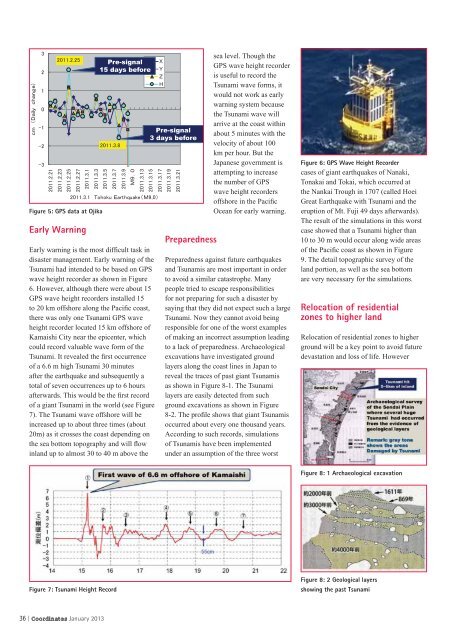
Figure 5: GPS data at Ojika<br />
Early Warning<br />
Pre-signal<br />
15 days before<br />
<br />
<br />
<br />
<br />
<br />
<br />
<br />
<br />
Early warning is the most diffi cult task in<br />
disaster management. Early warning of the<br />
Tsunami had intended to be based on GPS<br />
wave height recorder as shown in Figure<br />
6. However, although there were about 15<br />
GPS wave height recorders installed 15<br />
to 20 km offshore along the Pacifi c coast,<br />
there was only one Tsunami GPS wave<br />
height recorder located 15 km offshore of<br />
Kamaishi City near the epicenter, which<br />
could record valuable wave form of the<br />
Tsunami. It revealed the fi rst occurrence<br />
of a 6.6 m high Tsunami 30 minutes<br />
after the earthquake and subsequently a<br />
total of seven occurrences up to 6 hours<br />
afterwards. This would be the fi rst record<br />
of a giant Tsunami in the world (see Figure<br />
7). The Tsunami wave offshore will be<br />
increased up to about three times (about<br />
20m) as it crosses the coast depending on<br />
the sea bottom topography and will fl ow<br />
inland up to almost 30 to 40 m above the<br />
Figure 7: Tsunami Height Record<br />
36 | <strong>Coordinates</strong> January 2013<br />
<br />
<br />
<br />
<br />
Pre-signal<br />
3 days before<br />
<br />
<br />
<br />
Preparedness<br />
sea level. Though the<br />
GPS wave height recorder<br />
is useful to record the<br />
Tsunami wave forms, it<br />
would not work as early<br />
warning system because<br />
the Tsunami wave will<br />
arrive at the coast within<br />
about 5 minutes with the<br />
velocity of about 100<br />
km per hour. But the<br />
Japanese government is<br />
attempting to increase<br />
the number of GPS<br />
wave height recorders<br />
offshore in the Pacifi c<br />
Ocean for early warning.<br />
Preparedness against future earthquakes<br />
and Tsunamis are most important in order<br />
to avoid a similar catastrophe. Many<br />
people tried to escape responsibilities<br />
for not preparing for such a disaster by<br />
saying that they did not expect such a large<br />
Tsunami. Now they cannot avoid being<br />
responsible for one of the worst examples<br />
of making an incorrect assumption leading<br />
to a lack of preparedness. Archaeological<br />
excavations have investigated ground<br />
layers along the coast lines in Japan to<br />
reveal the traces of past giant Tsunamis<br />
as shown in Figure 8-1. The Tsunami<br />
layers are easily detected from such<br />
ground excavations as shown in Figure<br />
8-2. The profi le shows that giant Tsunamis<br />
occurred about every one thousand years.<br />
According to such records, simulations<br />
of Tsunamis have been implemented<br />
under an assumption of the three worst<br />
Figure 6: GPS Wave Height Recorder<br />
cases of giant earthquakes of Nanaki,<br />
Tonakai and Tokai, which occurred at<br />
the Nankai Trough in 1707 (called Hoei<br />
Great Earthquake with Tsunami and the<br />
eruption of Mt. Fuji 49 days afterwards).<br />
The result of the simulations in this worst<br />
case showed that a Tsunami higher than<br />
10 to 30 m would occur along wide areas<br />
of the Pacifi c coast as shown in Figure<br />
9. The detail topographic survey of the<br />
land portion, as well as the sea bottom<br />
are very necessary for the simulations.<br />
Relocation of residential<br />
zones to higher land<br />
Relocation of residential zones to higher<br />
ground will be a key point to avoid future<br />
devastation and loss of life. However<br />
Figure 8: 1 Archaeological excavation<br />
Figure 8: 2 Geological layers<br />
showing the past Tsunami


