

Inside - Coordinates
Inside - Coordinates
Inside - Coordinates

You also want an ePaper? Increase the reach of your titles
YUMPU automatically turns print PDFs into web optimized ePapers that Google loves.
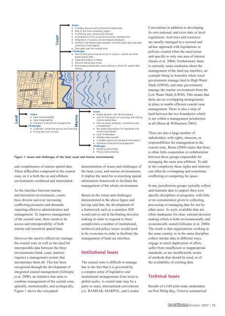
Land<br />
MANOR<br />
STREET<br />
WELLINGTONSTREET<br />
Coast<br />
Issues<br />
• Data interoperability<br />
• Data integratability<br />
• Immature institutional arrangements<br />
Challenges<br />
• Copyright, ownership privacy and licensing<br />
• Pricing and cost recovery<br />
and completeness of marine spatial data.<br />
These difficulties compound in the coastal<br />
zone, as it is both the on and offshore<br />
environments combined and interrelated.<br />
As the interface between marine<br />
and terrestrial environments, coasts<br />
have diverse and ever increasing<br />
conflicting pressures and demands<br />
requiring effective administration and<br />
management. To improve management<br />
of the coastal zone, there needs to be<br />
access and interoperability of both<br />
marine and terrestrial spatial data.<br />
ASTREET<br />
KEITHCOURT<br />
However the need to effectively manage<br />
the coastal zone as well as the need for<br />
interoperable data between the three<br />
environments (land, coast, marine)<br />
requires a management system that<br />
incorporates them all. This has been<br />
recognised through the development of<br />
integrated coastal management (Gillespie<br />
et al. 2000), an initiative that aims to<br />
combine management of the coastal zone,<br />
spatially, institutionally, and ecologically.<br />
Figure 1 shows the conceptual<br />
Issues<br />
• Complex physical and institutional relationship<br />
• One of the more hazardous region<br />
• Conflicting uses, activity and interests<br />
• Contribution to the social and economic development<br />
• Integration of oceanic and land-based databases<br />
• Inherent interrelationships between marine/coastal data and data<br />
covering in-land regions<br />
• Data gaps over the coastal zone<br />
Challenges<br />
• Harmonised and universal access to oceanic, coastal and landbased<br />
spatial data<br />
• Capacity building, funding<br />
• Security and privacy issues<br />
• Encouraging cooperation and creating a culture for spatial data<br />
sharing<br />
Marine<br />
Figure 1: Issues and challenges of the land, coast and marine environments<br />
Issues<br />
• Highly dynamic with 4D boundaries<br />
• Lack of framework for accessing and sharing<br />
marine spatial data<br />
• Poor accuracy, precision, consistency and<br />
completeness<br />
• No spatial descriptions for legislation and<br />
various boundaries<br />
• Lack of Metadata<br />
• Wireless data transfer<br />
• Complex spatial and temporal interactions<br />
• Immature institutional arrangements<br />
Challenges<br />
• Building partnerships<br />
• Privacy and sensitivity<br />
demonstration of issues and challenges of<br />
the land, coast, and marine environments.<br />
It implies the need for overarching spatial<br />
information framework to facilitate the<br />
management of the whole environment.<br />
Based on the issues and challenges<br />
demonstrated in the above figure and<br />
having said that, the development of<br />
a framework such as a seamless SDI<br />
would aim to aid in facilitating decision<br />
making in order to respond to these<br />
complexities a number of institutional,<br />
technical and policy issues would need<br />
to be overcome in order to facilitate the<br />
management of land sea interface.<br />
Institutional Issues<br />
The coastal zone is difficult to manage<br />
due to the fact that it is governed by<br />
a complex array of legislative and<br />
institutional arrangements from local to<br />
global scales. A coastal state may be a<br />
party to many international conventions<br />
(i.e. RAMSAR, MARPOL, and London<br />
Convention) in addition to developing<br />
its own national, and even state or local<br />
regulations. Activities and resources<br />
are usually managed in a sectoral and<br />
ad-hoc approach with legislations or<br />
policies created when the need arises<br />
and specific to only one area of interest<br />
(Strain et al. 2004). Furthermore, there<br />
is currently some confusion about the<br />
management of the land-sea interface, an<br />
example being in Australia where local<br />
governments manage land to High Water<br />
Mark (HWM), and state governments<br />
manage the marine environment from the<br />
Low Water Mark (LWM). This means that<br />
there are no overlapping arrangements<br />
in place to enable efficient coastal zone<br />
management. There is also a strip of<br />
land between the two boundaries which<br />
is not within a management jurisdiction<br />
at all (Binns & Williamson 2003).<br />
There are also a large number of<br />
stakeholders with rights, interests, or<br />
responsibilities for management in the<br />
coastal zone. Binns (2004) states that there<br />
is often little cooperation or collaboration<br />
between these groups responsible for<br />
managing the same area offshore. To add<br />
to the complexity these rights and interests<br />
can often be overlapping and sometimes<br />
conflicting or competing for space.<br />
In any jurisdictions groups typically collect<br />
and maintain data to support their own<br />
specific disciplines or programs, with little<br />
or no consideration given to collecting,<br />
processing or managing data for use by<br />
other users. As such, available data are<br />
often inadequate for clear, rational decision<br />
making which is both environmentally and<br />
economically sound (Gillespie et al. 2000).<br />
The result is that organisations working in<br />
the same country or in the same discipline<br />
collect similar data in different ways,<br />
engage in much duplication of effort,<br />
suffer from insufficient or inappropriate<br />
standards, or are insufficiently aware<br />
of methods that should be used, or of<br />
the availability of existing data.<br />
Technical Issues<br />
Results of a GIS pilot study undertaken<br />
on Port Philip Bay, Victoria summarised<br />
<strong>Coordinates</strong> October 2007 | 15


