

Inside - Coordinates
Inside - Coordinates
Inside - Coordinates

You also want an ePaper? Increase the reach of your titles
YUMPU automatically turns print PDFs into web optimized ePapers that Google loves.
government, and re-engineer the manner<br />
in which services are provided to common<br />
citizens. Under its ‘one-stop non-stop’<br />
approach, a pilot project called TWINS<br />
(Cities Integrated Network Services)<br />
integrated 18 services of six departments<br />
over one counter. It provides fast and easy<br />
access to government services, makes<br />
the government appear much simpler,<br />
and also cuts down on corruption.<br />
The government is able to keep database<br />
of citizens, which helps in better targeting<br />
of welfare programmes and minimise<br />
misuse of funds; Virtual town hall<br />
meetings allow citizens to watch the<br />
proceedings of municipal meetings, and<br />
also enable them to participate in decisionmaking,<br />
which otherwise is not subject<br />
to public debate. This participation in the<br />
form of interactive sessions, panels and<br />
discussion groups, planning consultations,<br />
chat lines, and electronic online voting<br />
is becoming commonplace. Expanding<br />
cable television networks have made<br />
it possible to deliver the electronic<br />
information into the homes of the people.<br />
The Government of Andhra Pradesh has<br />
come up with citizen utility centres called<br />
e-Sewa Centres, which are one-stop shops<br />
for various services such as payment of<br />
electricity, water and phone bills, property<br />
tax, sales tax and getting birth and death<br />
certificates. More than 20 centres are<br />
operating in Hyderabad. These centres are<br />
being opened in other parts of the State.<br />
HARIS in Haryana<br />
The HARIS (Haryana Registration<br />
Information System) provides a<br />
facilitates the registration of property<br />
documents. It functions very much<br />
like the SARITA of Maharashtra. The<br />
experience shows that e-Governance<br />
has improved public service, which has<br />
huge potential of its applications.<br />
Land Management Information<br />
System of the DDA<br />
The LMIS project was started in 2001<br />
to computerize the village wise land<br />
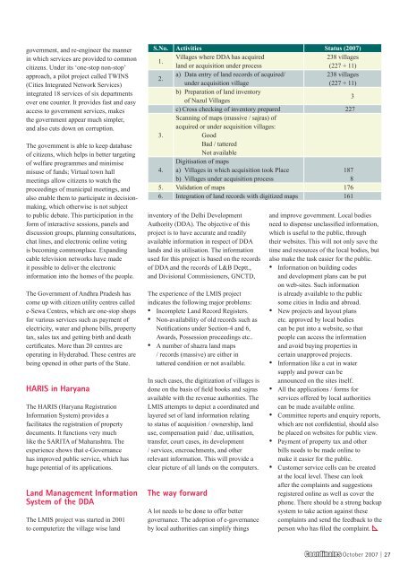
S.No. Activities Status (2007)<br />
1.<br />
Villages where DDA has acquired<br />
land or acquisition under process<br />
238 villages<br />
(227 + 11)<br />
2.<br />
a) Data entry of land records of acquired/<br />
under acquisition village<br />
238 villages<br />
(227 + 11)<br />
b) Preparation of land inventory<br />
of Nazul Villages<br />
3<br />
c) Cross checking of inventory prepared<br />
Scanning of maps (massive / sajras) of<br />
acquired or under acquisition villages:<br />
227<br />
3.<br />
Good<br />
Bad / tattered<br />
Not available<br />
Digitisation of maps<br />
4. a) Villages in which acquisition took Place<br />
187<br />
b) Villages under acquisition process<br />
8<br />
5. Validation of maps 176<br />
6. Integration of land records with digitized maps 161<br />
inventory of the Delhi Development<br />
Authority (DDA). The objective of this<br />
project is to have accurate and readily<br />
available information in respect of DDA<br />
lands and its utilisation. The information<br />
used for this project is based on the records<br />
of DDA and the records of L&B Deptt.,<br />
and Divisional Commissioners, GNCTD,<br />
The experience of the LMIS project<br />
indicates the following major problems:<br />
• Incomplete Land Record Registers.<br />
• Non-availability of old records such as<br />
Notifications under Section-4 and 6,<br />
Awards, Possession proceedings etc..<br />
• A number of shazra land maps<br />
/ records (massive) are either in<br />
tattered condition or not available.<br />
In such cases, the digitization of villages is<br />
done on the basis of field books and sajras<br />
available with the revenue authorities. The<br />
LMIS attempts to depict a coordinated and<br />
layered set of land information relating<br />
to status of acquisition / ownership, land<br />
use, compensation paid / due, utilisation,<br />
transfer, court cases, its development<br />
/ services, encroachments, and other<br />
relevant information. This will provide a<br />
clear picture of all lands on the computers.<br />
The way forward<br />
A lot needs to be done to offer better<br />
governance. The adoption of e-governance<br />
by local authorities can simplify things<br />
and improve government. Local bodies<br />
need to dispense unclassified information,<br />
which is useful to the public, through<br />
their websites. This will not only save the<br />
time and resources of the local bodies, but<br />
also make the task easier for the public.<br />
• Information on building codes<br />
and development plans can be put<br />
on web-sites. Such information<br />
is already available to the public<br />
some cities in India and abroad.<br />
• New projects and layout plans<br />
etc. approved by local bodies<br />
can be put into a website, so that<br />
people can access the information<br />
and avoid buying properties in<br />
certain unapproved projects.<br />
• Information like a cut in water<br />
supply and power can be<br />
announced on the sites itself.<br />
• All the applications / forms for<br />
services offered by local authorities<br />
can be made available online.<br />
• Committee reports and enquiry reports,<br />
which are not confidential, should also<br />
be placed on websites for public view.<br />
• Payment of property tax and other<br />
bills needs to be made online to<br />
make it easier for the public.<br />
• Customer service cells can be created<br />
at the local level. These can look<br />
after the complaints and suggestions<br />
registered online as well as cover the<br />
phone. There should be a strong backup<br />
system to take action against these<br />
complaints and send the feedback to the<br />
person who has filed the complaint.<br />
<strong>Coordinates</strong> October 2007 | 27


