

Inside - Coordinates
Inside - Coordinates
Inside - Coordinates

You also want an ePaper? Increase the reach of your titles
YUMPU automatically turns print PDFs into web optimized ePapers that Google loves.
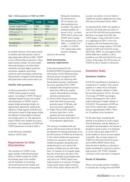
Table 1 Orbital parameters of VSOP and VSOP2<br />
Satellite<br />
Orbital parameters<br />
VSOP VSOP2<br />
Apogee height ha km 21400 25000<br />
Perigee height hp km 560 1000<br />
Orbit period T h 6.3 7.45<br />
Inclinatio i ° 46.4 or 31 31<br />
Arg.of perigee ω °<br />
285 315 or<br />
alterable<br />
Eccentricity ε 0.379 0.7<br />
RAAN Ω alterable -0.46<br />
be clarified. Because of the improvement<br />
of satellite orbit and structure, such as<br />
large deployable reflector (LDR), VSOP2<br />
is more efficient than its precursor. These<br />
improvements include: ten times higher<br />
observing frequency; ten times better<br />
resolution; ten times higher sensitivity;<br />
astrometric capability and further<br />
sensitivity gains from phase referencing;<br />
Measurement of magnetic fields through<br />
dual polarization observations and so on.<br />
Satellite orbit parameters<br />
As the next generation of VSOP,<br />
VSOP2 makes progress in many<br />
aspects. According to VSOP-2 Proposal<br />
Abridged English Version, the satellite<br />
orbit parameters of VSOP2, such as<br />
apogee height and perigee height, are<br />
appropriately adjusted by studying the<br />
influence of high angular resolution and<br />
orbit period caused by high apogee height,<br />
the influence of atmospheric resistance<br />
near perigee and so on. The adjustment<br />
makes VSOP2 more suitable for science<br />
researches. The comparison of VSOP and<br />
VSOP2 parameters is listed in Table 1.<br />
In the following, simulation<br />
analyses will be made.<br />
Requirements for Orbit<br />
Determination<br />
The simulation of VSOP2 in this<br />
paper includes: Orbit Determination<br />
(OD) of VSOP2 satellite by GNSS,<br />
the tracking status of the satellite<br />
and the feasibility of connecting<br />
observation between the satellite and<br />
the observation stations on the ground.<br />
During the stimulation,<br />
the orbit period is<br />
447.43 minutes and<br />
other parameters are<br />
invariable. The orbits of<br />
simulant satellites are<br />
shown in Fig 1, in which<br />
VSOP orbit is yellow and<br />
questionably VSOP2 orbit is purple.<br />
The simulant time is from<br />
2008 1 1 12:00:00 UTC<br />
to 2008 1 2 12:00:00<br />
UTC (almost three orbit<br />
periods). Sampling<br />
interval is 60 seconds.<br />
Orbit determination<br />
accuracy requirements<br />
In the report prepared by the<br />
RADIOASTRON Navigation Astrometry<br />
and Geodesy (NAG) Working Group<br />
about the precise navigation of the<br />
SVLBI satellite, the following orbit<br />
determination accuracy requirements<br />
have been specified (NAG, 1989):<br />
1) Standard Orbit: Required accuracy<br />
better than 1000 m for satellite<br />
control, orbit prediction, tracking<br />
and data communication.<br />
2) Precise Orbit: Required accuracy<br />
better than 50m for processing<br />
ground-to-space VLBI data, and<br />
most astrometric applications.<br />
3) Highly Precise Orbit: Required<br />
accuracy better than 1 m for<br />
geodetic and some astrometric.<br />
4) Required accuracy better than 0.1m<br />
for geodynamic applications.<br />
The accuracy of standard orbit and<br />
precise orbit has been achieved with the<br />
development of tracking technology. Even<br />
the OD accuracy of VSOP can be achieved<br />
3-10 m which satisfies the requirement<br />
of above two accuracies. But It is not<br />
suitable for geodetic and geodynamic<br />
studies because it can’t achieve the<br />
accuracy of highly precise orbit, better<br />
than 1 m, because of its irregular shape,<br />
big ratio of area/mass, the limit of the<br />
accuracy obtainable using Doppler data<br />
only and so on. VSOP2 makes some<br />
improvements in its structure. Its higher<br />
science goals request higher accuracy<br />
of OD. Some studies indicate that OD<br />
accuracy can achieve cm level which is<br />
suitable for geodetic applications by using<br />
GPS and accelerometer (ISAS, 2003).<br />
As reported (ISAS, 2003), the satellite in<br />
relatively low Earth orbit can achieve 5<br />
cm level OD with GPS and accelerometer.<br />
But there is no signal from GPS near<br />
VSOP apogee. Using GALILEO system<br />
as a supplement of GPS is a best way<br />
to improve OD. Pre-literature has been<br />
discussed the coverage instance of SVLBI<br />
satellite by GPS and GALILEO system<br />
(WEI Erhu, 2006). As some papers (IAIN/<br />
GNSS 2006) have studied, it will be<br />
possible to use GPS and GALILEO as one<br />
system. In this paper, the OD accuracy of<br />
VSOP2 by above situation is discussed.<br />
Simulation Study<br />
Simulation Condition<br />
GALILEO constellation in simulation is<br />
composed of 27 satellites. They spread<br />
equably in 3 orbits whose inclination<br />
is 56°. The satellite’s altitude is 23062<br />
km and orbit period is 14.0 hs. The ratio<br />
of coverage of VSOP2 near apogee,<br />
which is advantaged for OD, will be<br />
improved because of higher altitude of<br />
GALILEO. The parameters of GPS are<br />
from NASA website (ftp://cddis.gsfc.<br />
nasa.gov/gps/data/daily/2005/). There<br />
are 24 satellites in the simulation.<br />
On the other hand, considering the<br />
antenna is not globose to receive signal<br />
from all directions, and the influence of<br />
ionosphere and troposphere, the antenna is<br />
designed to point to space. It is designed<br />
as a cone with an apex angle of 80° to<br />
let the satellite to receive as more signals<br />
as possible. The coverage instance of<br />
VSOP2 by GPS and GALILEO system<br />
and its DOPs (PDOP which will be<br />
chose the best 6 satellites to calculate is<br />
mainly considered) is analyzed to achieve<br />
high accuracy OD. VSOP’s Simulant<br />
conclusion in the same time is compared.<br />
Results of Simulation<br />
There is not enough number of satellites<br />
to calculate the coverage time and PDOP<br />
<strong>Coordinates</strong> October 2007 | 21


