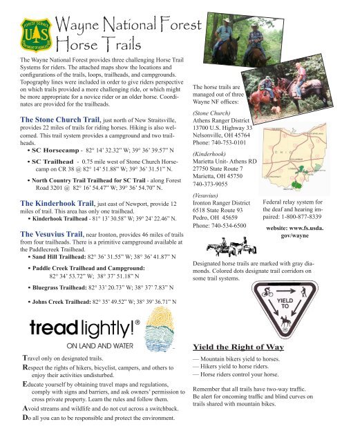
Wayne National Forest Horse Trails - USDA Forest Service
Wayne National Forest Horse Trails - USDA Forest Service
Wayne National Forest Horse Trails - USDA Forest Service

You also want an ePaper? Increase the reach of your titles
YUMPU automatically turns print PDFs into web optimized ePapers that Google loves.
<strong>Wayne</strong> <strong>National</strong> <strong>Forest</strong><br />
<strong>Horse</strong> <strong>Trails</strong><br />
The <strong>Wayne</strong> <strong>National</strong> <strong>Forest</strong> provides three challenging <strong>Horse</strong> Trail<br />
Systems for riders. The attached maps show the locations and<br />
configurations of the trails, loops, trailheads, and campgrounds.<br />
Topography lines were included in order to give riders perspective<br />
on which trails provided a more challenging ride, or which might<br />
be more appropriate for a novice rider or an older horse. Coordinates<br />
are provided for the trailheads.<br />
The Stone Church Trail, just north of New Straitsville,<br />
provides 22 miles of trails for riding horses. Hiking is also welcomed.<br />
This trail system provides a campground and two trailheads.<br />
• SC <strong>Horse</strong>camp - 82° 14’ 32.32” W; 39° 36’ 39.57” N<br />
• SC Trailhead - 0.75 mile west of Stone Church <strong>Horse</strong>-<br />
camp on CR 38 @ 82° 14’ 51.88” W; 39° 36’ 31.51” N.<br />
• North Country Trail Trailhead for SC Trail - along <strong>Forest</strong><br />
Road 3201 @ 82° 16’ 54.47” W; 39° 36’ 54.70” N.<br />
The Kinderhook Trail, just east of Newport, provide 12<br />
miles of trail. This area has only one trailhead.<br />
• Kinderhook Trailhead - 81° 13’ 30.58” W; 39° 24’ 22.46” N.<br />
The Vesuvius Trail, near Ironton, provides 46 miles of trails<br />
from four trailheads. There is a primitive campground available at<br />
the Paddlecreek Trailhead.<br />
• Sand Hill Trailhead: 82° 36’ 31.55” W; 38° 36’ 41.87” N<br />
• Paddle Creek Trailhead and Campground:<br />
82° 34’ 53.72” W; 38° 37’ 51.18” N<br />
• Bluegrass Trailhead: 82° 33’ 20.73” W; 38° 37’ 7.83” N<br />
• Johns Creek Trailhead: 82° 35’ 49.52” W; 38° 39’ 36.71” N<br />
Travel only on designated trails.<br />
Respect the rights of hikers, bicyclist, campers, and others to<br />
enjoy their activities undisturbed.<br />
Educate yourself by obtaining travel maps and regulations,<br />
comply with signs and barriers, and ask owners’ permission to<br />
cross private property. Learn the rules and follow them.<br />
Avoid streams and wildlife and do not cut across a switchback.<br />
Do all you can to be responsible and protect the environment.<br />
The horse trails are<br />
managed out of three<br />
<strong>Wayne</strong> NF offices:<br />
(Stone Church)<br />
Athens Ranger District<br />
13700 U.S. Highway 33<br />
Nelsonville, OH 45764<br />
Phone: 740-753-0101<br />
(Kinderhook)<br />
Marietta Unit- Athens RD<br />
27750 State Route 7<br />
Marietta, OH 45750<br />
740-373-9055<br />
(Vesuvius)<br />
Ironton Ranger District<br />
6518 State Route 93<br />
Pedro, OH 45659<br />
Phone: 740-534-6500<br />
Designated horse trails are marked with gray diamonds.<br />
Colored dots designate trail corridors on<br />
some trail systems.<br />
Yield the Right of Way<br />
— Mountain bikers yield to horses.<br />
— Hikers yield to horse riders.<br />
— <strong>Horse</strong> riders control your horse.<br />
Federal relay system for<br />
the deaf and hearing impaired:<br />
1-800-877-8339<br />
website: www.fs.usda.<br />
gov/wayne<br />
Remember that all trails have two-way traffic.<br />
Be alert for oncoming traffic and blind curves on<br />
trails shared with mountain bikes.
We Need Your Help!<br />
Adopt the Leave No Trace and Tread Lightly ethics.<br />
For more information on these programs, contact our office.<br />
Encourage others to also practice these land ethics.<br />
Report vandalism - missing signs, unsafe<br />
conditions, suspicious vehicles, etc.<br />
Pick up after yourself and others, leave the area<br />
cleaner than you found it.<br />
Respect closed areas. Stay on the trail, cutting switchbacks<br />
damages trails and causes erosion.<br />
Consider volunteering for a work project.<br />
Several organized groups regularly volunteer and help<br />
maintain these trails and would welcome your help.<br />
Contact a Ranger District office if you wish to volunteer.<br />
For Your Information<br />
Riders must obey all state traffic laws when<br />
riding on public roads.<br />
√ Private land surrounds trail routes. Please<br />
stay on marked trails to avoid riding on private land.<br />
Respect other landowner’s rights.<br />
√ <strong>Horse</strong>s are permitted on designated horse trails or<br />
open public roads. A designated horse trail is a trail<br />
marked by gray diamond blazes.<br />
√ <strong>National</strong> <strong>Forest</strong> lands are open to public hunting.<br />
Please be aware of the various hunting seasons and plan<br />
your trail ride accordingly.<br />
√ Sections of the horse trail cross or follow township<br />
and county roads. Please use caution when traveling on<br />
these motorized routes.<br />
√ Camping may be done in small openings along the<br />
trail but no vegetation should be cut and all fires must be<br />
extinquished before leaving camp.<br />
√ Bring your own water.. Water in ponds and streams<br />
may be used for horses, but is unsafe for human consumption.<br />
√ Be alert for ticks, snakes, and poison ivy.<br />
√ Pack out everything you pack in.<br />
√ For safety, please don’t ride alone. Let someone<br />
know where you’ll be riding and when to expect you<br />
back.<br />
√ Please<br />
notify our<br />
offices of any<br />
down trees<br />
across the<br />
trail.<br />
In case of accidents:<br />
If another rider is critically injured,<br />
call 911. When calling for help,<br />
note the closest landmark or intersection<br />
to the victim’s location. If<br />
you suspect a back or neck injury,<br />
do NOT move the rider. Medical<br />
assistance will be there as soon as<br />
possible.<br />
Trail Permits<br />
Plan Ahead and Prepare<br />
Travel and Camp on Durable Surfaces<br />
Dispose of Waste Properly<br />
Leave What You Find<br />
Minimize Campfire Impacts<br />
Respect Wildlife<br />
Be Considerate of other Visitors<br />
<strong>Horse</strong>back riders age 16 and older are required to have a<br />
permit when riding trails on the <strong>Wayne</strong> N.F. Riders 15 and<br />
younger should be accompanied by an adult.<br />
Seasonal ($45/season), 3-day ($24), and daily ($12/day).<br />
Printable trail permits may be purchased online and printed<br />
from home or any location with access to the internet and a<br />
color printer. Traditional permits are also available from any<br />
<strong>Wayne</strong> NF office or participating vendor locations. Click on<br />
the <strong>Wayne</strong> NF homepage at www.fs.usda.gov/wayne and then<br />
click on “Purchase Trail Permits Online” under Quick Links<br />
in the right hand column. Permits must<br />
be visually displayed while on the trails.<br />
Funds collected from the<br />
sale of permits goes toward<br />
maintaining trails to standard<br />
and rerouting trails to make<br />
them safer.<br />
<strong>USDA</strong> is an equal opportunity<br />
provider and employer.