
You also want an ePaper? Increase the reach of your titles
YUMPU automatically turns print PDFs into web optimized ePapers that Google loves.
<strong>23.3</strong> <strong>Water</strong> <strong>Shapes</strong> <strong>the</strong> <strong>Land</strong><br />
Key Concepts<br />
What is <strong>the</strong> most important<br />
factor influencing <strong>the</strong><br />
ability of a stream to<br />
cause erosion?<br />
What features are formed<br />
by surface water erosion?<br />
What features are deposited<br />
by running water?<br />
What causes groundwater<br />
erosion?<br />
Vocabulary<br />
◆ deposition<br />
◆ saltation<br />
◆ flood plain<br />
◆ meander<br />
◆ oxbow lake<br />
◆ alluvial fan<br />
◆ delta<br />
◆ stalactite<br />
◆ stalagmite<br />
◆ sinkhole<br />
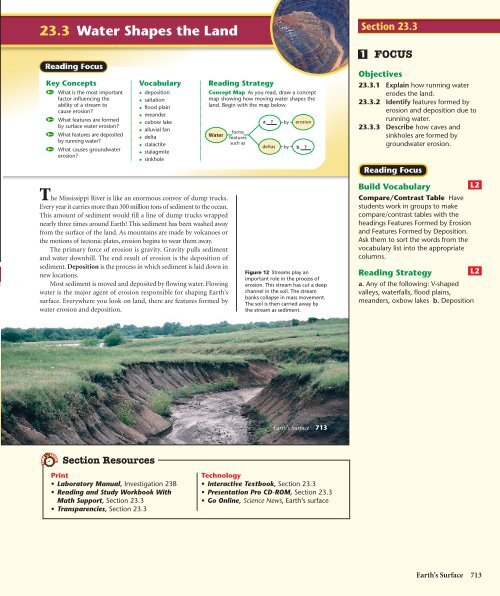
The Mississippi River is like an enormous convoy of dump trucks.<br />
Every year it carries more than 300 million tons of sediment to <strong>the</strong> ocean.<br />
This amount of sediment would fill a line of dump trucks wrapped<br />
nearly three times around Earth! This sediment has been washed away<br />
from <strong>the</strong> surface of <strong>the</strong> land. As mountains are made by volcanoes or<br />
<strong>the</strong> motions of tectonic plates, erosion begins to wear <strong>the</strong>m away.<br />
The primary force of erosion is gravity. Gravity pulls sediment<br />
and water downhill. The end result of erosion is <strong>the</strong> deposition of<br />
sediment. Deposition is <strong>the</strong> process in which sediment is laid down in<br />
new locations.<br />
Most sediment is moved and deposited by flowing water. Flowing<br />
water is <strong>the</strong> major agent of erosion responsible for shaping Earth’s<br />
surface. Everywhere you look on land, <strong>the</strong>re are features formed by<br />
water erosion and deposition.<br />
Section Resources<br />
Print<br />
• Laboratory Manual, Investigation 23B<br />
• Reading and Study Workbook With<br />
Math Support, Section <strong>23.3</strong><br />
• Transparencies, Section <strong>23.3</strong><br />
Reading Strategy<br />
Concept Map As you read, draw a concept<br />
map showing how moving water shapes <strong>the</strong><br />
land. Begin with <strong>the</strong> map below.<br />
<strong>Water</strong><br />
forms<br />
features<br />
such as<br />
a. ?<br />
by<br />
erosion<br />
deltas by b. ?<br />
Figure 12 Streams play an<br />
important role in <strong>the</strong> process of<br />
erosion. This stream has cut a deep<br />
channel in <strong>the</strong> soil. The stream<br />
banks collapse in mass movement.<br />
The soil is <strong>the</strong>n carried away by<br />
<strong>the</strong> stream as sediment.<br />
Earth’s Surface 713<br />
Technology<br />
• Interactive Textbook, Section <strong>23.3</strong><br />
• Presentation Pro CD-ROM, Section <strong>23.3</strong><br />
• Go Online, Science News, Earth’s surface<br />
Section <strong>23.3</strong><br />
1<br />
FOCUS<br />
Objectives<br />
<strong>23.3</strong>.1 Explain how running water<br />
erodes <strong>the</strong> land.<br />
<strong>23.3</strong>.2 Identify features formed by<br />
erosion and deposition due to<br />
running water.<br />
<strong>23.3</strong>.3 Describe how caves and<br />
sinkholes are formed by<br />
groundwater erosion.<br />
Reading Focus<br />
Build Vocabulary<br />
Compare/Contrast Table Have<br />
students work in groups to make<br />
compare/contrast tables with <strong>the</strong><br />
headings Features Formed by Erosion<br />
and Features Formed by Deposition.<br />
Ask <strong>the</strong>m to sort <strong>the</strong> words from <strong>the</strong><br />
vocabulary list into <strong>the</strong> appropriate<br />
columns.<br />
Reading Strategy<br />
a. Any of <strong>the</strong> following: V-shaped<br />
valleys, waterfalls, flood plains,<br />
meanders, oxbow lakes b. Deposition<br />
L2<br />
L2<br />
Earth’s Surface 713
Section <strong>23.3</strong> (continued)<br />
2<br />
INSTRUCT<br />
Running <strong>Water</strong><br />
Erodes <strong>the</strong> <strong>Land</strong><br />
Forming Sedimentary<br />
Layers<br />
Objective<br />
After completing this activity, students<br />
will be able to<br />
• describe <strong>the</strong> formation of sedimentary<br />
layers under water.<br />
Skills Focus Using Models<br />
Prep Time 15 minutes<br />
Advance Prep Sand, clay, and gravel<br />
can be obtained from a landscaper,<br />
garden supply shop, or home repair<br />
store. Olive jars are ideal for this lab.<br />
Graduated cylinders with rubber<br />
stoppers can be used if <strong>the</strong> stoppers<br />
make a watertight seal.<br />
Class Time 20 minutes<br />
Expected Outcome Gravel settles<br />
first, <strong>the</strong>n sand, and finally clay. Some<br />
clay remains suspended in <strong>the</strong> water,<br />
making <strong>the</strong> water cloudy.<br />
Analyze and Conclude<br />
1. Gravel, sand, and clay<br />
2. Some clay remained suspended in <strong>the</strong><br />
water, making <strong>the</strong> water cloudy.<br />
3. <strong>Water</strong> in a lake. It was not moving<br />
quickly and it contained suspended<br />
particles.<br />
4. The separation of sand and clay<br />
would have been less distinct. This<br />
would occur in a turbulent, fast-moving<br />
river such as one with rapids.<br />
Kines<strong>the</strong>tic<br />
For Enrichment<br />
714 Chapter 23<br />
L2<br />
L3<br />
Use a soil-sampling tube or a section of<br />
pipe to collect a core sample of<br />
sediment from a riverbed or <strong>the</strong> bottom<br />
of a lake. Students can use a hand lens<br />
or microscope to examine <strong>the</strong> particle<br />
sizes in each layer and determine <strong>the</strong>ir<br />
distribution. Variation in particle size in<br />
<strong>the</strong>se layers may reflect seasonal or<br />
historical changes in <strong>the</strong> speed or<br />
volume of <strong>the</strong> water from which <strong>the</strong><br />
sediment was deposited. Students<br />
should wear safety goggles, lab aprons,<br />
and plastic gloves during this activity.<br />
Kines<strong>the</strong>tic<br />
Forming Sedimentary Layers<br />
Materials<br />
clay; gravel; sand; small dish; tall, narrow jar with<br />
cover; tablespoon; clock or watch<br />
Procedure<br />
1. Crumble <strong>the</strong> clay into a fine powder over a<br />
small dish.<br />
2. Fill <strong>the</strong> jar three quarters full of water. Add one<br />
spoonful each of gravel, sand, and clay.<br />
3. Put <strong>the</strong> cover on <strong>the</strong> jar tightly and invert <strong>the</strong><br />
jar several times. Then, place <strong>the</strong> jar on a flat<br />
surface and record <strong>the</strong> time.<br />
4. For 5 minutes, observe <strong>the</strong> layers of sediment<br />
as <strong>the</strong>y pile up on <strong>the</strong> bottom of <strong>the</strong> jar.<br />
Record what you observe.<br />
Figure 13 Small grains of<br />
sediment are carried in<br />
suspension by a stream. Large<br />
grains move by sliding or rolling,<br />
and medium-sized grains move by<br />
saltation. Material is also carried<br />
in dissolved form. Predicting<br />
How might <strong>the</strong> speed of <strong>the</strong><br />
stream affect <strong>the</strong> amount and<br />
size of particles it can carry?<br />
Suspended sediment is<br />
carried by flowing water.<br />
714 Chapter 23<br />
Running <strong>Water</strong> Erodes <strong>the</strong> <strong>Land</strong><br />
<strong>Water</strong> from rain or melted snow may soak into <strong>the</strong> ground, evaporate,<br />
or flow over <strong>the</strong> surface as runoff. Erosion begins when runoff carries<br />
small particles of soil downhill. Runoff gradually forms small channels<br />
in <strong>the</strong> soil. These channels join toge<strong>the</strong>r to form larger channels<br />
called gullies. As water flows down a hillside through gullies, <strong>the</strong> water<br />
can erode large quantities of soil. Gullies, in turn, flow toge<strong>the</strong>r to form<br />
streams. Unlike gullies, streams flow year-round, except in dry areas<br />
or during droughts.<br />
Streams continue <strong>the</strong> process of erosion by transporting sediment,<br />
as shown in Figure 13. Most of <strong>the</strong> sediment in streams is carried in<br />
suspension, in which tiny sediment grains move along with <strong>the</strong> water.<br />
Larger particles of sediment slide, roll, or bounce along <strong>the</strong> bottom of<br />
a stream. The process of particles bouncing along a stream bottom is<br />
called saltation. During floods, a fast-moving river can move boulders<br />
<strong>the</strong> size of a small car. A large amount of sediment is also carried in<br />
solution. Faster streams carry more sediment, which increases abrasion.<br />
Dissolved sediment<br />
moves with flowing water.<br />
5. Observe <strong>the</strong> appearance of <strong>the</strong> water in <strong>the</strong> jar.<br />
Record your observations.<br />
Analyze and Conclude<br />
1. Observing In what order did <strong>the</strong> sediment<br />
layers form?<br />
2. Inferring Why did <strong>the</strong> water look <strong>the</strong> way it<br />
did after <strong>the</strong> sediment layers formed?<br />
3. Using Models Was <strong>the</strong> water in <strong>the</strong> jar<br />
similar to <strong>the</strong> water in a lake or <strong>the</strong> water in a<br />
fast-moving river? Explain your answer.<br />
4. Predicting Would <strong>the</strong> order of <strong>the</strong> sediment<br />
layers be different if you had stirred <strong>the</strong> water<br />
as <strong>the</strong> layers accumulated? Under what<br />
circumstances would this happen in nature?<br />
Direction of flow<br />
Large particles are pushed<br />
or rolled along <strong>the</strong> streambed.<br />
Customize for English Language Learners<br />
Use Flowcharts<br />
Have students work in groups to create flowcharts<br />
describing <strong>the</strong> formation of alluvial fans<br />
and deltas. As an extension, students could also<br />
Medium-sized particles<br />
move by saltation.<br />
create flowcharts for some or all of <strong>the</strong> features<br />
formed by water erosion, wind erosion, and<br />
wind deposition. Students should use <strong>the</strong>ir own<br />
words and/or drawings in <strong>the</strong> flowcharts.
Sediment<br />
Meander<br />
A stream’s ability to erode depends mainly on its speed. The<br />
water in a mountain stream moves quickly because it is flowing down a<br />
steep slope. Fast streams carry more sediment than slow streams of equal<br />
size. Fast streams can also carry large sediment grains. As a stream flows<br />
toward <strong>the</strong> sea, its slope decreases. This can make <strong>the</strong> stream move more<br />
slowly, causing larger sediments to settle on <strong>the</strong> stream bottom.<br />
Features Formed by <strong>Water</strong> Erosion<br />
Erosion by flowing water reshapes entire watersheds—all <strong>the</strong> land<br />
along and between streams and rivers. <strong>Water</strong> erosion forms<br />
V-shaped valleys, waterfalls, meanders, and oxbow lakes. Figure 14<br />
shows <strong>the</strong> features formed along <strong>the</strong> course of a river.<br />
V-Shaped Valleys Near a stream’s source, <strong>the</strong> stream flows fast as<br />
it plunges down steep slopes. As a stream erodes <strong>the</strong> rock of its<br />
streambed, it causes <strong>the</strong> valley’s sides to become steeper. Mass movement<br />
on <strong>the</strong> stream slopes causes a V-shaped valley with sharply angled<br />
sides to form.<br />
V-shaped valleys often contain rapids and waterfalls. A waterfall<br />
may develop where a stream crosses rock layers that differ in hardness.<br />
The harder layers resist erosion, forming <strong>the</strong> top of <strong>the</strong> waterfall. The<br />
softer rock layers downstream are worn away, leaving <strong>the</strong> cliff over<br />
which <strong>the</strong> waterfall tumbles.<br />
How do waterfalls form?<br />
Facts and Figures<br />
Great <strong>Water</strong>falls The world’s tallest<br />
waterfall is Angel Falls, Venezuela, at an<br />
amazing height of 979 m, almost a kilometer!<br />
Yosemite Falls is <strong>the</strong> tallest waterfall in <strong>the</strong><br />
United States, falling an impressive 739 m.<br />
<strong>Water</strong>fall<br />
River mouth<br />
V-shaped valley<br />
Oxbow lake<br />
Figure 14 As a river winds its<br />
way from <strong>the</strong> mountains to <strong>the</strong><br />
ocean, it changes <strong>the</strong> surrounding<br />
landscape through erosion<br />
and deposition.<br />
Comparing and Contrasting<br />
Which features formed by river<br />
erosion typically form near a<br />
river’s source?<br />
For: Articles on Earth’s surface:<br />
wea<strong>the</strong>ring, erosion, and<br />
deposition<br />
Visit: PHSchool.com<br />
Web Code: cce-3233<br />
Earth’s Surface 715<br />
Science News provides students<br />
with current information on<br />
Earth’s surface: wea<strong>the</strong>ring,<br />
erosion, and deposition.<br />
FYI<br />
Though sediment is continuously moved<br />
by flowing streams, <strong>the</strong> occasional<br />
floods can increase sediment transport<br />
by more than 100 times. During <strong>the</strong><br />
huge Mississippi River flood of 1993, <strong>the</strong><br />
river level was more than 50 feet above<br />
normal in places, and both <strong>the</strong> stream<br />
velocity and sediment load increased<br />
dramatically. Floods are also extremely<br />
dangerous. More than 5 million people<br />
have died from flooding in China in <strong>the</strong><br />
past 100 years.<br />
Features Formed by<br />
<strong>Water</strong> Erosion<br />
Use Visuals<br />
L1<br />
Figure 14 Explain that, as <strong>the</strong> streams<br />
cut down into <strong>the</strong> rock, <strong>the</strong> V-shaped<br />
valley slopes become steeper. When <strong>the</strong><br />
valleys become very steep, waterfalls<br />
form or mass movement can occur, and<br />
rock and soil falls into <strong>the</strong> stream in <strong>the</strong><br />
form of landslides or slumps. Once <strong>the</strong><br />
rock and soil falls into <strong>the</strong> water, it is<br />
quickly washed downstream. When<br />
a river flows across a flat area, <strong>the</strong><br />
V-shaped valley may be very broad<br />
and hard to recognize. The floor of <strong>the</strong><br />
valley is called <strong>the</strong> floodplain. At what<br />
location is <strong>the</strong> river most able to carry<br />
large rocks? (In <strong>the</strong> mountains) What<br />
is <strong>the</strong> source of much of <strong>the</strong> sediment<br />
being deposited on <strong>the</strong> flood plain?<br />
(The mountains shown in <strong>the</strong> background)<br />
What feature will result from <strong>the</strong><br />
buildup of sediment where <strong>the</strong> river<br />
flows into <strong>the</strong> ocean? (A delta)<br />
Visual<br />
Answer to . . .<br />
Figure 13 The greater <strong>the</strong> speed of a<br />
stream, <strong>the</strong> more kinetic energy it<br />
possesses and <strong>the</strong> larger <strong>the</strong> amount<br />
and size of particles it can carry.<br />
Figure 14 V-shaped valleys and<br />
waterfalls<br />
<strong>Water</strong>falls may form<br />
where a river crosses<br />
rock layers of different hardnesses. The<br />
harder layers of rock resist erosion,<br />
forming <strong>the</strong> top of <strong>the</strong> waterfall. The<br />
softer layers of rock downstream are<br />
eroded, creating a cliff over which <strong>the</strong><br />
waterfall tumbles.<br />
Earth’s Surface 715
Section <strong>23.3</strong> (continued)<br />
Build Reading Literacy L1<br />
Visualize Refer to page 354D in<br />
Chapter 12, which provides <strong>the</strong><br />
guidelines for visualizing.<br />
Instruct students to close <strong>the</strong>ir eyes and<br />
form mental pictures as you read Flood<br />
Plains. Read aloud to <strong>the</strong> students,<br />
going slowly so that <strong>the</strong>y have time to<br />
form mental images of <strong>the</strong> processes<br />
you are describing. Then, tell <strong>the</strong><br />
students to read <strong>the</strong> passage again by<br />
<strong>the</strong>mselves and recreate <strong>the</strong> mental<br />
images as <strong>the</strong>y read. Explain that<br />
visualizing <strong>the</strong> text as <strong>the</strong>y read will be<br />
particularly useful throughout <strong>the</strong> next<br />
few pages, which detail <strong>the</strong> processes by<br />
which landforms are created by erosion<br />
and deposition.<br />
Intrapersonal, Visual<br />
A common misconception among<br />
students is that Earth’s features, such as<br />
mountains, do not change. A related<br />
misconception is that any changes that<br />
occur are sudden and catastrophic,<br />
resulting in <strong>the</strong> complete destruction of<br />
an old feature or <strong>the</strong> sudden creation of<br />
a new feature. The erosion of mountain<br />
valleys by running water is an ideal<br />
context in which to address this<br />
misconception. Explain that erosion is a<br />
slow, constant process that wears down<br />
old landforms. New landforms are<br />
created through erosion and deposition,<br />
often over thousands to millions of years.<br />
Verbal<br />
Features Formed by<br />
<strong>Water</strong> Deposition<br />
Build Science Skills<br />
716 Chapter 23<br />
L2<br />
L2<br />
Inferring Bring a variety of river rocks<br />
into class. Have students work in groups<br />
to make inferences about <strong>the</strong> geologic<br />
history of <strong>the</strong> rocks. Explain that <strong>the</strong>y<br />
should use what <strong>the</strong>y have learned<br />
about <strong>the</strong> formation of rocks and <strong>the</strong><br />
rock cycle to describe <strong>the</strong> history of each<br />
rock from its formation to its erosion<br />
and deposition. Have students create a<br />
flowchart for each rock’s history.<br />
Logical, Kines<strong>the</strong>tic<br />
Figure 15 Rivers often form<br />
winding meanders across <strong>the</strong>ir<br />
flood plain. An oxbow lake<br />
formed by <strong>the</strong> Big Sioux River<br />
near Westfield, Iowa, is shown.<br />
A<br />
B<br />
Figure 16 Alluvial fans and<br />
deltas form from sediment<br />
deposited by moving water.<br />
A This alluvial fan in Death Valley,<br />
California, formed from sediment<br />
deposited when a mountain<br />
stream reached flat land. B When<br />
a large river empties into <strong>the</strong><br />
ocean, <strong>the</strong> deposited sediment<br />
often forms a delta.<br />
716 Chapter 23<br />
Facts and Figures<br />
Deltas The word delta comes from <strong>the</strong> Greek<br />
letter delta (). The river feature received this<br />
name from <strong>the</strong> Greek historian Herodotus,<br />
who noticed that <strong>the</strong> Nile River delta had a<br />
shape similar to that of <strong>the</strong> triangular symbol<br />
for <strong>the</strong> Greek letter.<br />
Flood Plains Where a river or stream crosses gently sloping land,<br />
a flood plain forms. A flood plain is <strong>the</strong> flat area along a stream that is<br />
entirely covered only during times of flood. As a river flows across its<br />
flood plain, it deposits sediment, making <strong>the</strong> flood plain flat. Over<br />
time, this sediment builds up into long, low ridges called natural levees.<br />
These natural levees help prevent a river from spilling over its banks.<br />
During very large floods, however, a river may overflow its levees and<br />
erosion may fur<strong>the</strong>r widen <strong>the</strong> valley.<br />
Where a river curves slightly, <strong>the</strong> water on <strong>the</strong> outside of <strong>the</strong> curve<br />
moves more rapidly than <strong>the</strong> water on <strong>the</strong> inside. Fast-moving water<br />
causes more erosion. Therefore, <strong>the</strong> river tends to remove soil from <strong>the</strong><br />
outside of <strong>the</strong> curve. Sediment is deposited on <strong>the</strong> inside of <strong>the</strong> curve,<br />
where water moves more slowly. Over time, this process forms a looplike<br />
bend in <strong>the</strong> river called a meander.<br />
Sometimes during a flood, <strong>the</strong> river erodes through a narrow neck<br />
of land at <strong>the</strong> base of a meander and forms a new path. Sediments build<br />
up along <strong>the</strong> new channel, cutting <strong>the</strong> old meander off from <strong>the</strong> rest of<br />
<strong>the</strong> river. The result is a separate, curved lake, called an oxbow lake.<br />
Figure 15 shows an oxbow lake formed by <strong>the</strong> Big Sioux River.<br />
Features Formed by <strong>Water</strong> Deposition<br />
As a stream or river slows down, it begins to deposit sediment. The<br />
slower water cannot carry larger particles of sediment, so <strong>the</strong>se particles<br />
fall to <strong>the</strong> bottom first. As <strong>the</strong> water slows down even more, smaller<br />
particles of sediment are deposited. Features deposited by flowing<br />
water include alluvial fans and deltas.<br />
As a stream flows out of <strong>the</strong> mountains and onto <strong>the</strong> plains, it slows<br />
down and sediment settles out. The result is a fan-shaped deposit of<br />
sediment on land called an alluvial fan. As shown in Figure 16, alluvial<br />
fans often grow into thick deposits of sediment.<br />
When a stream flows into a lake or an ocean, <strong>the</strong> water slows down.<br />
The sediment that <strong>the</strong> stream was carrying is deposited in <strong>the</strong> form of<br />
a delta. A delta is a mass of sediment deposited where a river enters a<br />
large body of water. Some deltas have a roughly triangular shape.<br />
However, not all deltas have a triangular<br />
shape. The Mississippi River, for example, has<br />
a birdfoot-shaped delta that extends far out<br />
into <strong>the</strong> Gulf of Mexico.
Groundwater Erosion<br />
Erosion and deposition occur below ground as well as at <strong>the</strong><br />
surface. The processes of chemical wea<strong>the</strong>ring causes<br />
much groundwater erosion, including <strong>the</strong> formation of caves<br />
and sinkholes. Recall that carbon dioxide in <strong>the</strong> air combines<br />
with rainwater to form carbonic acid. As <strong>the</strong> acidic rainwater<br />
moves down through <strong>the</strong> ground, it reacts with some rocks and<br />
may become more acidic.<br />
Limestone easily erodes away through this process, forming<br />
caves, or caverns. Most caves are small, narrow passages,<br />
but some are hundreds of feet high and wide. Caves usually<br />
form when <strong>the</strong>y are in <strong>the</strong> saturated zone, below <strong>the</strong> water<br />
table. When <strong>the</strong> water table drops, <strong>the</strong> water flows downward,<br />
leaving dry caves like <strong>the</strong> one in Figure 17.<br />
Sometimes water drips into <strong>the</strong> cavern from <strong>the</strong> rock layers<br />
above, carrying dissolved minerals. When this mineral-laden<br />
water reaches <strong>the</strong> air of <strong>the</strong> cave, some of <strong>the</strong> dissolved carbon<br />
dioxide escapes and <strong>the</strong> minerals are left behind. If <strong>the</strong> water drips<br />
from <strong>the</strong> cavern ceiling, an icicle-like formation called a stalactite<br />
(stuh LAK tyt) grows. If <strong>the</strong> water drips down to <strong>the</strong> floor, a pillar<br />
of minerals called a stalagmite (stuh LAG myt) forms.<br />
If erosion weakens a layer of limestone, entire portions of<br />
<strong>the</strong> ground can suddenly collapse. The resulting hole is called<br />
a sinkhole. Areas of <strong>the</strong> sou<strong>the</strong>rn and central United States have<br />
many sinkholes. Sinkholes can appear suddenly, swallowing<br />
buildings and roads.<br />
Section <strong>23.3</strong> Assessment<br />
Reviewing Concepts<br />
1. What is <strong>the</strong> major factor that affects <strong>the</strong><br />
ability of a stream to erode land?<br />
2. As a stream erodes <strong>the</strong> land, what<br />
features are likely to form in steep areas?<br />
What features form in more level areas?<br />
3. Compare and contrast deltas and<br />
alluvial fans.<br />
4. What process forms caves and sinkholes?<br />
5. What force provides <strong>the</strong> energy for <strong>the</strong> erosion<br />
caused by running water?<br />
Critical Thinking<br />
6. Applying Concepts What determines how<br />
much sediment flowing water can carry?<br />
Section <strong>23.3</strong> Assessment<br />
1. The stream’s speed<br />
2. V-shaped valleys and waterfalls; a flood<br />
plain, oxbow lakes, and meanders<br />
3. Deltas and alluvial fans both form when a<br />
river slows down or ends, depositing<br />
sediment. However, deltas form in water and<br />
alluvial fans form on land.<br />
4. Caves and sinkholes form by <strong>the</strong> chemical<br />
dissolution of underground rock by <strong>the</strong> flow of<br />
acidic water. If erosion weakens a layer of<br />
Figure 17 Carlsbad Caverns in New Mexico<br />
contain spectacular formations, such as <strong>the</strong><br />
stalactites and stalagmites shown here.<br />
7. Relating Cause and Effect How does an<br />
oxbow lake form?<br />
8. Comparing and Contrasting What<br />
is <strong>the</strong> difference between a stalactite and<br />
a stalagmite?<br />
Describing a Process Imagine that you are<br />
a particle of sediment on a mountaintop. Write<br />
a paragraph describing your journey to <strong>the</strong><br />
ocean. (Hint: Be sure to mention at least three<br />
steps in <strong>the</strong> transportation of sediment.)<br />
Earth’s Surface 717<br />
limestone below <strong>the</strong> ground, it may collapse<br />
and form a sinkhole.<br />
5. Gravity provides <strong>the</strong> energy for erosion<br />
caused by <strong>the</strong> downward flow of rivers and<br />
streams to <strong>the</strong> ocean.<br />
6. The speed that <strong>the</strong> water flows. <strong>Water</strong> can<br />
carry more sediment when it flows faster.<br />
7. An oxbow lake forms when a river erodes<br />
through a narrow neck of land and a meander<br />
gets cut off.<br />
8. A stalactite hangs from <strong>the</strong> ceiling of a<br />
cave, while a stalagmite sticks up from <strong>the</strong><br />
floor of a cave.<br />
Groundwater Erosion<br />
Use Community<br />
Resources<br />
L2<br />
Most states have caves. Contact your<br />
regional USGS office or State Park<br />
Service to find out about caves in your<br />
area. Ask a park ranger or geologist to<br />
present a slide show to your class that<br />
includes pictures of caves in your region.<br />
If possible, arrange a field trip to a<br />
nearby cave.<br />
Visual, Kines<strong>the</strong>tic<br />
3<br />
ASSESS<br />
Evaluate<br />
Understanding<br />
Have students create a flowchart that<br />
explains how an oxbow lake like <strong>the</strong> one<br />
in Figure 15 formed.<br />
Reteach<br />
Use Figure 14 to explain <strong>the</strong> features<br />
formed by water erosion.<br />
Students’ paragraphs should describe<br />
how a particle could be transported<br />
downhill by runoff from a storm. They<br />
should describe how <strong>the</strong> particle continues<br />
to be carried downhill through small<br />
channels of water into a gully, <strong>the</strong>n into<br />
a small stream, a large stream, or a river.<br />
Depending on <strong>the</strong> size of <strong>the</strong> particle,<br />
<strong>the</strong>y should fur<strong>the</strong>r describe how it is<br />
carried in suspension, by saltation, or is<br />
rolled along <strong>the</strong> bottom of <strong>the</strong> riverbed<br />
until it reaches <strong>the</strong> ocean, where it may<br />
be deposited in a delta or carried out to<br />
<strong>the</strong> deep ocean floor.<br />
If your class subscribes<br />
to <strong>the</strong> Interactive Textbook, use it to<br />
review key concepts in Section <strong>23.3</strong>.<br />
L2<br />
L1<br />
Earth’s Surface 717
Section <strong>23.3</strong> (continued)<br />
Should Cave Access<br />
Be Restricted?<br />
Background<br />
While investigating a small cave in <strong>the</strong><br />
side of a limestone sinkhole, Randy Tufts<br />
and Gary Tenen noticed a breeze coming<br />
out of a crack in <strong>the</strong> rock. This indicated<br />
<strong>the</strong> presence of a larger cave.<br />
Answers<br />
1. Students should explain <strong>the</strong> major<br />
issues outlined in <strong>the</strong> text. These issues<br />
include: Should living caves be developed<br />
at all? What is <strong>the</strong> scientific value of preserving<br />
such caves? What are <strong>the</strong> risks<br />
and rewards of developing living caves?<br />
If such caves are developed, how can this<br />
best be done?<br />
2. Those in favor of opening living caves<br />
to <strong>the</strong> public argue that development<br />
will educate <strong>the</strong> public, create new jobs<br />
in <strong>the</strong> region, and protect <strong>the</strong> caves<br />
from potential damage by vandals. They<br />
assert that with proper equipment and<br />
safeguards, <strong>the</strong> risk of visitor damage to<br />
<strong>the</strong> caves is small. Those opposed to<br />
opening such caves to <strong>the</strong> public argue<br />
that each is a unique geological and<br />
biological laboratory. They believe that<br />
opening such caves would be too risky.<br />
Even under <strong>the</strong> best circumstances,<br />
<strong>the</strong>y argue, <strong>the</strong> living caves would be<br />
damaged and will “die.”<br />
3. Students should clearly express <strong>the</strong>ir<br />
opinion about <strong>the</strong> possible development<br />
of living caves and provide supporting<br />
arguments for <strong>the</strong>ir opinion.<br />
4. Students should prepare a letter to<br />
<strong>the</strong>ir governor containing a series of<br />
specific recommendations. Sample<br />
recommendations might include: “Limit<br />
<strong>the</strong> number of people that can visit <strong>the</strong><br />
cave, and use <strong>the</strong> proceeds from<br />
admissions to establish a scientific<br />
research program for <strong>the</strong> cave.” or “The<br />
cave should not be developed. It should<br />
be preserved for scientific research.”<br />
Have students fur<strong>the</strong>r research<br />
<strong>the</strong> issues related to this topic.<br />
718 Chapter 23<br />
L2<br />
Let <strong>the</strong> Caverns Be<br />
A living cave undisturbed by public access provides<br />
scientists with a unique laboratory. Because of<br />
caverns’ isolation from <strong>the</strong> surface world, organisms<br />
found nowhere else sometimes evolve. Caverns also<br />
hold evidence of climate change and fossils of<br />
extinct animals.<br />
Proponents of cave preservation argue that even<br />
under <strong>the</strong> best circumstances, human visitors<br />
change a cave’s environment for <strong>the</strong> worse. They<br />
cite Carlsbad Caverns as a case in point. Each year,<br />
about 600,000 people visit Carlsbad Caverns. The<br />
visitors have taken bits and pieces of rock as<br />
souvenirs. They have disrupted <strong>the</strong> narrow range of<br />
temperature and humidity needed for limestone<br />
deposits to form.<br />
1. Defining <strong>the</strong> Issue In your own words, explain<br />
<strong>the</strong> major issues involved in preservation versus<br />
development of limestone caverns.<br />
2. Analyzing <strong>the</strong> Viewpoints What are <strong>the</strong> risks<br />
and benefits of opening caverns to <strong>the</strong> public?<br />
What is <strong>the</strong> value of preserving <strong>the</strong>m solely for<br />
scientific research?<br />
3. Forming Your Opinion Should caverns like<br />
Kartchner Caverns be open to <strong>the</strong> public? Give<br />
reasons for your opinion.<br />
718 Chapter 23<br />
Facts and Figures<br />
Cave Life Lechuguilla Cave, inside Carlsbad<br />
Caverns National Park in New Mexico, has<br />
been kept closed to all but scientific<br />
researchers since its discovery in 1986. Even<br />
scientific access has been limited. Only six<br />
expeditions are allowed per year with no more<br />
Should Cave Access Be Restricted?<br />
In a limestone cavern, it can take 300 years to add one centimeter of rock to<br />
a stalactite! These and o<strong>the</strong>r formations build up drop by drop. In a “living”<br />
cave, deposits form under conditions of constant temperature and high<br />
humidity. If <strong>the</strong>se conditions change, <strong>the</strong> formation of new deposits stops,<br />
and <strong>the</strong> cave “dies.”<br />
In 1974, two explorers discovered a cavern outside Tucson, Arizona. The<br />
two cavers had to wriggle through a narrow, hidden tunnel to reach a<br />
network of magnificent caverns that stretched for several kilometers.<br />
Eventually, <strong>the</strong> state of Arizona decided to develop <strong>the</strong> caverns as Kartchner<br />
Caverns State Park. Cave experts designed special systems that allow access<br />
to <strong>the</strong> cave, but minimize <strong>the</strong> impact of visitors on <strong>the</strong> caverns’ fragile<br />
environment. Some scientists, however, are concerned that even <strong>the</strong>se<br />
special systems will not be enough to maintain Kartchner Caverns as a<br />
“living” cave. Should all caverns be opened to <strong>the</strong> public?<br />
The Viewpoints<br />
Research and Decide<br />
Let <strong>the</strong> People See<br />
Proponents of opening living caves to <strong>the</strong> public<br />
maintain that <strong>the</strong> beauty of such caverns simply<br />
demands to be seen. Caverns provide an important<br />
recreational and educational resource. They bring<br />
jobs to <strong>the</strong> region where <strong>the</strong>y are located. In<br />
addition, development may help protect caves that<br />
would o<strong>the</strong>rwise be vulnerable to vandals.<br />
At Kartchner Caverns, an air lock at <strong>the</strong> entrance<br />
maintains <strong>the</strong> caverns’ environmental conditions.<br />
Blowers remove lint and dust from <strong>the</strong> visitors’<br />
clothing. Walkways are designed to keep visitors<br />
hands away from cavern walls—skin oils disrupt <strong>the</strong><br />
process by which limestone is deposited. With <strong>the</strong>se<br />
safeguards, human impact on <strong>the</strong> cave should<br />
be minimal.<br />
4. Persuasive Writing Suppose that you have<br />
discovered a cavern. Write a letter to your<br />
governor presenting your position regarding<br />
whe<strong>the</strong>r <strong>the</strong> cavern should be opened to <strong>the</strong><br />
public or preserved for research.<br />
For: More on this issue<br />
Visit: PHSchool.com<br />
Web code: cch-3233<br />
than 12 researchers on each expedition.<br />
Scientists have been studying microorganisms<br />
in Lechuguilla Cave to get an idea of what life<br />
on Mars might be like. Opening <strong>the</strong> cave to<br />
tourists would probably destroy <strong>the</strong>se<br />
microorganisms.