Yarra State Forest - Department of Sustainability and Environment
Yarra State Forest - Department of Sustainability and Environment
Yarra State Forest - Department of Sustainability and Environment

Create successful ePaper yourself
Turn your PDF publications into a flip-book with our unique Google optimized e-Paper software.
<strong>Yarra</strong> <strong>State</strong> <strong>Forest</strong><br />
Paul Pearson-Powelltown<br />
<strong>Yarra</strong> <strong>State</strong> <strong>Forest</strong><br />
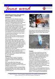
Situated only 80 km east <strong>of</strong> Melbourne, the <strong>Yarra</strong> <strong>State</strong><br />
<strong>Forest</strong> (managed by the <strong>Department</strong> <strong>of</strong> <strong>Sustainability</strong> <strong>and</strong><br />
<strong>Environment</strong> - DSE) provides some <strong>of</strong> the best forest<br />
walks <strong>and</strong> drives in close proximity to Melbourne. Choose<br />
from a range <strong>of</strong> short or long walks, picnic or camping<br />
areas <strong>and</strong> lookouts in the mighty mountain ash forests <strong>of</strong><br />
the region.<br />
Getting there<br />
From Melbourne, head out along the Maroondah Highway<br />
to Lilydale. Past Lilydale, turn right onto the Warburton<br />
Highway. At the township <strong>of</strong> <strong>Yarra</strong> Junction, turn right at<br />
the traffic lights <strong>and</strong> travel onto Powelltown in the heart <strong>of</strong><br />
the <strong>Yarra</strong> <strong>State</strong> forest to the orientation <strong>and</strong> information<br />
board in the town centre or continue through the traffic<br />
lights to Warburton <strong>and</strong> visit the Water Wheel Tourist<br />
Information Centre.<br />
Flora <strong>and</strong> fauna<br />
Powelltown <strong>and</strong> the surrounding area is renown for its<br />
mighty forests: the mountain ash forests being one <strong>of</strong> the<br />
most productive ecosystems in the world. However, on<br />
closer inspection, the <strong>Yarra</strong> forests support a much broader<br />
diversity <strong>of</strong> native vegetation than might first seem<br />
apparant. They include:<br />
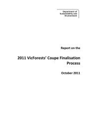
• Wet sclerophyll forests dominated by the majestic<br />
Mountain Ash (E. regnans). Regnans means reigning,<br />
accurately describing the world’s tallest hardwood.<br />
Typically straight <strong>and</strong> tall, some grow to over 100m in<br />
height.<br />
• Damp sclerophyll forest<br />
occuring at slightly lower<br />
altitudes, <strong>of</strong> Mountain<br />
Grey Gum (E.<br />
cypellocarpa) <strong>and</strong><br />
Messmate (E. obliqua).<br />
• Cool temperate rainforest<br />
dominated by Mrytle<br />
Beech (Noth<strong>of</strong>agus<br />
cunninghamii) <strong>and</strong>/or<br />
Southern Sassafras (Atherosperma moschatum)<br />
occuring in moist sheltered gullies.<br />
The forests surrounding Powelltown support a variety <strong>of</strong><br />
native fauna species. These include; swamp wallabies,<br />
wombats, platypus, echidnas <strong>and</strong> several species <strong>of</strong><br />
possums <strong>and</strong> gliders. One bird <strong>of</strong> note is the Superb<br />
Lyrebird, unique to Australia.<br />
March 2004<br />
FS0033<br />
ISSN 1440-2262<br />
The Lyrebird is a great mimic <strong>and</strong> is able to imitate the<br />
calls <strong>of</strong> many other birds including the kookaburra, pied<br />
currawong <strong>and</strong> crimson rosella.<br />
Walking tracks<br />
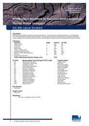
1. Ada Tree<br />
Skill Level 1 : Basic Fitness Level: Low<br />
3.2km, 1.5 hrs return<br />
Journey through Myrtle Beech Rainforest to visit the Ada<br />
Tree, one <strong>of</strong> the largest known flowering trees in the<br />
world. Estimated at over 300 years old, the Ada Tree<br />
st<strong>and</strong>s about 76m tall with a circumference <strong>of</strong> 15m<br />
measured at 1.5 m above ground level. The walk begins at<br />
the picnic area on<br />
Ada River Rd,<br />
following Isl<strong>and</strong><br />
Creek to the Ada<br />
Tree. Return to the<br />
picnic area along the<br />
same route. If you<br />
have time, allow an<br />
extra 45 minutes to<br />
visit the New Federal<br />
Mill. Just continue<br />
1.4km along the walking track at the Ada Tree.<br />
2. Seven Acre Rock<br />
Skill Level: Moderate Fitness Level: Average<br />
1.2km, 30 mins return.<br />
This short easy walk leads to Seven Acre Rock, a granite<br />
rock outcrop which provides comm<strong>and</strong>ing views <strong>of</strong> the<br />
Bunyip <strong>State</strong> Park, Western Port Bay <strong>and</strong> Port Phillip Bay<br />
on a clear day. The walk starts from the picnic area, 500<br />
metres east <strong>of</strong> the junction <strong>of</strong> Learmonth Creek Road <strong>and</strong><br />
Bunyip Road.<br />
3. Reids Tramline<br />
Skill Level: Basic Fitness Level: Average<br />
6km, 2.5 hr return.<br />
This walk follows the route <strong>of</strong> the historic tramline along<br />
which horses, <strong>and</strong> later, steam locomotives once hauled<br />
logs out <strong>of</strong> the forest. Begin at the picnic area opposite the<br />
DSE <strong>of</strong>fice <strong>and</strong> head east through the town. Pass the<br />
present day mill (look out for the original workers cottages<br />
above the mill) before picking up the original tramline at<br />
1 To assist visitors in choosing walks, the walks are classified by skill<br />
level <strong>and</strong> fitness level. For a description <strong>of</strong> these classifications, refer to<br />
the <strong>Forest</strong>s Note ‘FS0020 - Bushwalking in <strong>State</strong> <strong>Forest</strong>’<br />
© <strong>State</strong> <strong>of</strong> Victoria, <strong>Department</strong> <strong>of</strong> <strong>Sustainability</strong> <strong>and</strong> <strong>Environment</strong> Page 1
<strong>Yarra</strong> <strong>State</strong> <strong>Forest</strong> FS0033<br />
the eastern end <strong>of</strong> the town. Relics <strong>of</strong> the former mill <strong>and</strong><br />
tramline can still be seen on this walk. Return along the<br />
same route or for a more challenging walk return via Big<br />
Bertha Track.<br />
4. Spion Kopje<br />
Skill Level: Moderate Fitness Level: Average<br />
1km; 45 mins return.<br />
A short, but slightly challenging walk to Spion Kopje<br />
lookout for views across the Tarago forest <strong>and</strong> Latrobe<br />
Valley. Approximately 15 km further on from Seven Acre<br />
Rock. The walk is signposted <strong>of</strong>f Limberlost Road.<br />
5. La La Falls<br />
Skill Level: Moderate Fitness Level: Average<br />
3.2km, 1.5 hrs return.<br />
An enjoyable walk through tall Mountain Ash <strong>and</strong> lush tree<br />
ferns, before reaching the picturesque falls. Follow the<br />
signs from Park Road along Old Warburton Road to the<br />
start <strong>of</strong> the track on Irruka Road. The falls are said to be<br />
named after past l<strong>and</strong>owner Leila Ward, whose guest<br />
house “La La” (meaning Welcome Welcome) was located<br />
in the area.<br />
6. Walk into History<br />
Skill Level: Fitness Level:<br />
33km, 2 days (one way)<br />
The Walk into History follows<br />
some well preserved sections<br />
<strong>of</strong> the historic timber<br />
tramlines, past old mills <strong>and</strong><br />
other relics <strong>of</strong> the early timber<br />
industry. Several creek<br />
crossings are required <strong>and</strong> a<br />
map <strong>of</strong> the area is essential.<br />
Due to the steepness <strong>of</strong> the<br />
High Lead section, the easiest<br />
way to do the walk is from<br />
Warburton or Big Pats Creek<br />
down to Powelltown.<br />
The walk can be done in sections as detailed below.<br />
6a. Warburton to Big Pats picnic area<br />
Skill Level: Fitness Level:<br />
6.5km, 2 hrs<br />
Follow the Centenary Trail <strong>and</strong> Big Pat’s Creek Rd to Big<br />
Pat’s Creek Recreation Area.<br />
6b. Big Pats picnic area to Starlings Gap<br />
Skill Level: Fitness Level:<br />
9km, 3.5 hrs<br />
This section <strong>of</strong> the walk follows the Federal tramway <strong>and</strong><br />
was constructed in 1933. Bush workers used to walk this<br />
section on a Sunday evening to be ready to begin work<br />
early Monday morning. On a Saturday afternoon however,<br />
some workers were known to have run the 9 km distance<br />
back to Big Pats Creek in time to make the weekly football<br />
match. Two sawdust heaps are all that remains to indicate<br />
the sites <strong>of</strong> the bush mills along this section. The first<br />
marks the site <strong>of</strong> Ezards sawmill, the second near Starlings<br />
Gap operated here until 1942. Starlings Gap provides a<br />
good place to rest, explore or even camp overnight before<br />
beginning the next section. When at Starlings Gap take a<br />
few minutes to visit the old winch <strong>and</strong> boiler located on a<br />
level track 200m past the toilet block.<br />
6c. Starlings Gap to Ada No.2 Mill<br />
Skill Level: Fitness Level:<br />
8km, 3 hrs.<br />
The journey to the Ada No2 Mill takes walkers through the<br />
Ada River Valley. In the first 2 km <strong>of</strong> this walk alone,<br />
nine trestle bridges were required to move timber from the<br />
mill to Starlings Gap. 7.5km into this section visitors<br />
reach the tramway junction known as the ‘crossroads’.<br />
From this intersection you can head north to the New Ada<br />
Mill (2.8km return), or east to the Federal Mill (4.3km<br />
return) <strong>and</strong> Ada Tree (5.7km return) or continue the walk<br />
south to the Ada No.2 Mill.<br />
6d. Ada No.2 Mill to Highlead Carpark<br />
Skill Level: Fitness Level:<br />
5.5km, 2.5 hrs.<br />
This section leads visitors through forest that has seen the<br />
effects <strong>of</strong> both the Black Friday fires <strong>of</strong> 1939 <strong>and</strong> more<br />
recently the Ash Wednesday fires <strong>of</strong> 1983. The high lead<br />
marks the start <strong>of</strong> the most difficult section <strong>of</strong> the walk.<br />
The track drops 415 metres in 1600 metres, a grade <strong>of</strong><br />
almost 1 in 4.<br />
6e. Highlead Carpark to Powelltown picnic area<br />
Skill Level: Fitness Level:<br />
10.5km, 3 hrs.<br />
The track follows the Latrobe River, crossing it numerous<br />
times before arriving at ‘The Bump’, the divide between<br />
the Little <strong>Yarra</strong> <strong>and</strong> Latrobe Rivers. This site is also<br />
known for ‘The Bump Tunnel’, an historic railway tunnel<br />
constructed in 1925. Spanning 313 metres in length, the<br />
tunnel was constructed to avoid winching up the existing<br />
steep inclines. Evidence <strong>of</strong> the tunnel can be seen along<br />
the walk. Here the track leaves the Latrobe <strong>and</strong> joins the<br />
Little <strong>Yarra</strong> River, where it makes its way back to<br />
Powelltown.<br />
The number <strong>of</strong> sections per day depends on experience <strong>and</strong><br />
fitness. Please obtain further information from DSE <strong>of</strong>fice.<br />
Map: The Ada River, Spion Kopje <strong>and</strong> Gladysdale sheets<br />
in the 1:25 000 VICMAP series cover this walk.<br />
7.Richards Tramline<br />
Skill Level: Fitness Level:<br />
9km one way, 3 hrs<br />
This walk, which follows an old logging tramline, winds<br />
it’s way up the Mississippi Valley towards Starvation<br />
Creek. The track starts opposite the Big Pats Creek Picnic<br />
Area (800m along Smyth Creek Road from the bridge over<br />
© <strong>State</strong> <strong>of</strong> Victoria, <strong>Department</strong> <strong>of</strong> <strong>Sustainability</strong> <strong>and</strong> <strong>Environment</strong> Page 2
<strong>Yarra</strong> <strong>State</strong> <strong>Forest</strong> FS0033<br />
Big Pats Creek) <strong>and</strong> finishes on Brahams Road. The first<br />
2km <strong>of</strong> track, known as ‘The Curves’, gets its name from<br />
the series <strong>of</strong> bends constructed along the tramline to allow<br />
for a steady descent from Mississippi Fireline towards Big<br />
Pats Creek.<br />
For keen walkers who wish to explore the area further,<br />
DSE <strong>of</strong>ficers in Powelltown will be more than happy to<br />
give you information on other walks in the area.<br />
Camping<br />
Latrobe River Camping Area <strong>and</strong> Starlings Gap are the<br />
main campgrounds in the <strong>Yarra</strong> <strong>State</strong> <strong>Forest</strong>. Both<br />
campgrounds have toilet facilities, picnic tables <strong>and</strong><br />
fireplaces. Camping is on a first-come first-served basis<br />
<strong>and</strong> no bookings are required, but early arrival may be<br />
advisable during peak periods.<br />
Picnic sites<br />
Picnic facilities are available at the Powelltown, Starlings<br />
Gap, Seven Acre Rock, Big Pats Creek, Latrobe River <strong>and</strong><br />
Ada Tree picnic areas.<br />
Driving in the forest<br />
All <strong>of</strong> the camping sites, picnic sites <strong>and</strong> walking tracks in<br />
the <strong>Yarra</strong> <strong>State</strong> forest are accessible from well formed<br />
gravel roads. These roads are suitable for vehicles for<br />
most <strong>of</strong> the year, but care should be taken after rain.<br />
Snowfalls can occur at higher altitudes such as Starlings<br />
Gap <strong>and</strong> the Ada Tree.<br />
Take care on forest roads, they are generally narrow <strong>and</strong><br />
winding <strong>and</strong> remember that the roads are used by many<br />
vehicles, including log trucks, so please adjust your<br />
driving accordingly.<br />
Looking after our forests<br />
• Dogs are allowed in <strong>State</strong> forest but must be under<br />
direct control at all times <strong>and</strong> are expected to be kept<br />
on a leash in picnic <strong>and</strong> camping areas or when near<br />
other visitors.<br />
• Bikes <strong>and</strong> horses are generally not permitted on<br />
walking tracks. Please observe access signs <strong>and</strong> help<br />
protect the forest.<br />
• Don't disturb native plants or animals.<br />
• There is no rubbish collection service, so please take<br />
your rubbish home. If you have the misfortune to come<br />
across other people’s rubbish, do the bush a favour <strong>and</strong><br />
take it out with you too.<br />
• Take care with fire – observe all fire regulations <strong>and</strong><br />
Total Fire Ban days. Use existing fireplaces rather<br />
than create your own. Never leave fires unattended.<br />
Ensure fires are safe <strong>and</strong> that they are completely<br />
extinguished when you leave.<br />
• Only light fires in fireplaces or 30 cm deep trenches.<br />
Fires must be less than 1 metre square <strong>and</strong> at least 3 m<br />
clear <strong>of</strong> burnable material.<br />
• Keep the size <strong>of</strong> your group small, ideally, less than<br />
eight people <strong>and</strong> go <strong>of</strong>f peak.<br />
• Vehicles <strong>and</strong> trail bikes must be registered <strong>and</strong><br />
roadworthy <strong>and</strong> may only be driven on designated<br />
public roads <strong>and</strong> tracks.<br />
• Make sure you tell someone where you are going <strong>and</strong><br />
when you expect to return, <strong>and</strong> don't forget to let them<br />
know when you are back.<br />
For more information<br />
The <strong>Department</strong> <strong>of</strong> <strong>Sustainability</strong> <strong>and</strong> <strong>Environment</strong> (DSE)<br />
is responsible for managing Victoria's <strong>State</strong> <strong>Forest</strong>. For<br />
further information contact the <strong>Department</strong> <strong>of</strong><br />
<strong>Sustainability</strong> <strong>and</strong> <strong>Environment</strong> <strong>of</strong>fice at Powelltown (<br />
5966 7203) or the DSE Customer Service Centre on 136<br />
186.<br />
Visit DSE’s website<br />
http://www.dse.vic.gov.au<br />
then select “<strong>Forest</strong>ry”.<br />
The <strong>Yarra</strong> <strong>State</strong> <strong>Forest</strong> is managed for a wide range <strong>of</strong> uses<br />
including catchment protection, timber production,<br />
recreation <strong>and</strong> conservation. If you are interested in how<br />
<strong>State</strong> <strong>Forest</strong>s are managed, the current Central Highl<strong>and</strong>s<br />
<strong>Forest</strong> Management Plan can be viewed on the<br />
<strong>Department</strong>'s website on the Internet at<br />
http://www.dse.vic.gov.au<br />
then select “<strong>Forest</strong>ry”, then select “Publications”.<br />
This publication may be <strong>of</strong> assistance to you but the <strong>State</strong> <strong>of</strong> Victoria<br />
<strong>and</strong> its <strong>of</strong>ficers do not guarantee that the publication is without flaw<br />
<strong>of</strong> any kind or is wholly appropriate for your particular purposes<br />
<strong>and</strong> therefore disclaims all liability for any error, loss or other<br />
consequence which may arise from you relying on any information<br />
in this publication.<br />
© <strong>State</strong> <strong>of</strong> Victoria, <strong>Department</strong> <strong>of</strong> <strong>Sustainability</strong> <strong>and</strong> <strong>Environment</strong> Page 3
<strong>Yarra</strong> <strong>State</strong> <strong>Forest</strong> FS0033<br />
To<br />
Healesville<br />
To Lilydale<br />
LAUNCHING PLACE<br />
McCrae<br />
To Gembrook<br />
C505<br />
Don River<br />
DON<br />
GEMBROOK<br />
ROAD<br />
C506<br />
HAINING<br />
PARK<br />
BEN<br />
WARBURTON<br />
Launching<br />
Place<br />
C424<br />
ROAD<br />
C424<br />
Hoddles<br />
CAIRN<br />
<strong>Yarra</strong><br />
<strong>Yarra</strong><br />
Junction<br />
PARKINSON<br />
WEST<br />
l<br />
Ben Cairn<br />
B380<br />
YARRA RANGES NATIONAL PARK<br />
Creek<br />
BEENAK<br />
ROAD<br />
C425<br />
ROAD<br />
Dee<br />
Britannia<br />
Creek<br />
EAST<br />
Millgrove<br />
OLD<br />
TARRANGO<br />
LITTLE<br />
HIGHWAY<br />
Wesburn<br />
Little<br />
Gladysdale<br />
ROAD<br />
River<br />
BEENAK<br />
BEENAK<br />
River<br />
WARBURTON<br />
KURTH KILN REGIONAL PARK<br />
ROAD<br />
BRITANNIA<br />
MOUNT<br />
l Mt Donna Buang<br />
<strong>Yarra</strong><br />
YARRA<br />
ROAD<br />
DONNA<br />
ROAD<br />
Basan Corner<br />
lTomahawk<br />
Gap<br />
C505<br />
BUANG<br />
Warburton<br />
ROAD<br />
CREEK<br />
YARRA STATE FOREST<br />
Mt Beenak<br />
l<br />
Bunyip<br />
MOUNT<br />
Creek<br />
PORTAS<br />
BUNYIP STATE PARK<br />
WAY<br />
ROAD<br />
5<br />
lLa<br />
La<br />
Falls<br />
ROAD<br />
ROAD<br />
BLACK<br />
ACHERON<br />
BRIDE<br />
Lake Lake<br />
Mautore Mautore<br />
TORBET<br />
C507<br />
ROAD<br />
River<br />
ROAD<br />
BUNYIP<br />
YARRA STATE FOREST<br />
l Mt Bride<br />
Mt Myrtalial<br />
WARBURTON<br />
WARBURTON<br />
SANDS<br />
Powelltown<br />
Picnic Area<br />
River<br />
Warburton<br />
East<br />
Big Pats<br />
Recreation<br />
Area<br />
ROAD<br />
Powelltown<br />
LEARMONTH<br />
Seven Acre Rock<br />
6a<br />
2<br />
ROAD<br />
l<br />
CREEK<br />
Seven<br />
Acre<br />
Rock<br />
ROAD<br />
LYREBIRD<br />
lReids<br />
Mill<br />
3<br />
YARRA RANGES NATIONAL P<br />
MONETT<br />
TURNER<br />
ROAD<br />
6b<br />
ROAD<br />
MISSISSIPPI<br />
SMYTH<br />
Starlings<br />
Gap<br />
ROAD<br />
ROAD<br />
KOBIOLKE<br />
FITZPATRICK<br />
C425<br />
WOODS<br />
BRAHAM<br />
CREEK<br />
ROAD<br />
ROAD<br />
<strong>Yarra</strong><br />
O’SHANNASSY ROAD<br />
STARVATION<br />
7<br />
ROAD<br />
6e<br />
ROAD<br />
BIG<br />
POWELLTOWN<br />
ROAD<br />
CREEK<br />
PIONEER
OAD<br />
TIONAL PARK<br />
SY ROAD<br />
<strong>Yarra</strong><br />
TARVATION<br />
7<br />
OAD<br />
6e<br />
ROAD<br />
BIG<br />
TOWN<br />
ROAD<br />
CREEK<br />
PIONEER<br />
POINT<br />
Ada<br />
CREEK<br />
BIG<br />
LaTrobe<br />
CREEK<br />
ROAD<br />
River<br />
CREEK<br />
DOWEY<br />
ROAD<br />
ROAD<br />
McMahons<br />
Creek<br />
MUDDY<br />
ROAD<br />
YARRA STATE FOREST<br />
6c<br />
C511<br />
New Ada Milll<br />
Ada No2 Mill l<br />
6d<br />
High Lead<br />
Carpark<br />
SPUR<br />
NOOJEE<br />
4<br />
Spion Kopjel<br />
To Upper<br />
<strong>Yarra</strong><br />
Reservoir<br />
Little<br />
Ada<br />
River<br />
ROAD<br />
River<br />
Ada<br />
Tree<br />
l<br />
l<br />
Federal Mill<br />
River<br />
1<br />
ROAD<br />
McMAHONS<br />
LIMBERLOST<br />
BOUNDARY<br />
CREEK<br />
RIVER<br />
Latrobe River<br />
Camping Area<br />
NEW<br />
ROAD<br />
TURKEY<br />
ROAD<br />
McMahons<br />
ROAD<br />
SPUR<br />
ROAD<br />
ROAD<br />
Creek<br />
McCARTHY<br />
ROAD<br />
LOWER<br />
ROAD<br />
LaTrobe<br />
BOUNDARY<br />
BENNIES<br />
ROAD<br />
ROAD<br />
SPUR<br />
Whites Corner<br />
Upper<br />
<strong>Yarra</strong><br />
Reservoir<br />
YARRA RANGES NATIONAL PARK<br />
LATROBE STATE FOREST<br />
Nayook<br />
River<br />
ROAD<br />
C425<br />
To Noojee<br />
To Neerim<br />
South<br />
l<br />
ston<br />
MELBA<br />
1<br />
ã<br />
N<br />
HWY<br />
MAROONDAH<br />
D<strong>and</strong>enong<br />
l<br />
MELBOURNE<br />
lH<br />
Marysville<br />
l<br />
YARRA<br />
Matl<br />
l<br />
lHealesville<br />
STATE FOREST<br />
PRINCES<br />
HWY<br />
WARBURTON<br />
HWY<br />
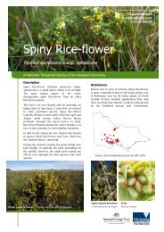
<strong>Yarra</strong> <strong>State</strong> <strong>Forest</strong><br />
Highway<br />
Sealed road<br />
Minor unsealed road<br />
Walking track<br />
Gate<br />
<strong>State</strong> <strong>Forest</strong><br />
Parks & Reserves<br />
Water body<br />
Walk number<br />
Recreational<br />
Facilities<br />
Camping<br />
Fireplace<br />
Lookout<br />
<strong>Forest</strong> information<br />
Picnic table<br />
Toilets<br />
0 1 2<br />
KILOMETRES<br />
Cartography by Spatial Vision 2003<br />
M/7403<br />
l<br />
Warburton<br />
l<br />
Powelltown<br />
HWY<br />
l Neerim<br />
South<br />
Warragul<br />
l<br />
This publication may be <strong>of</strong> assistance to you but the <strong>State</strong> <strong>of</strong> Victoria <strong>and</strong> its <strong>of</strong>ficers do not guarantee that the publication is without flaw <strong>of</strong> any kind or is<br />
wholly appropriate for your particular purposes <strong>and</strong> therefore disclaims all liability for any error, loss or other consequence which may arise from you<br />
relying on any information in this publication.<br />
© <strong>State</strong> <strong>of</strong> Victoria, <strong>Department</strong> <strong>of</strong> <strong>Sustainability</strong> <strong>and</strong> <strong>Environment</strong><br />
Jamies<br />
l<br />
Moe

![Metcalfe State Forest Fauna Species List [PDF File - 16.9 KB]](https://img.yumpu.com/22024301/1/184x260/metcalfe-state-forest-fauna-species-list-pdf-file-169-kb.jpg?quality=85)
![PPE Price List for Wildlife Volunteers [PDF File - 20.3 KB]](https://img.yumpu.com/15321634/1/190x135/ppe-price-list-for-wildlife-volunteers-pdf-file-203-kb.jpg?quality=85)