Grading Plan Check - City of Escondido
Grading Plan Check - City of Escondido
Grading Plan Check - City of Escondido

Create successful ePaper yourself
Turn your PDF publications into a flip-book with our unique Google optimized e-Paper software.
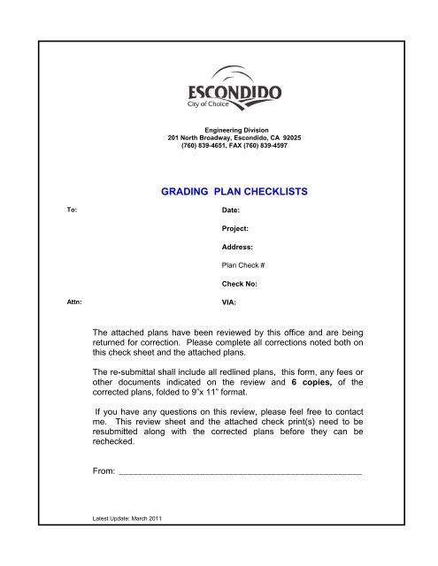
Latest Update: March 2011<br />
Engineering Division<br />
201 North Broadway, <strong>Escondido</strong>, CA 92025<br />
(760) 839-4651, FAX (760) 839-4597<br />
GRADING PLAN CHECKLISTS<br />
To: Date:<br />
Project:<br />
Attn: VIA:<br />
Address:<br />
<strong>Plan</strong> <strong>Check</strong> #<br />
<strong>Check</strong> No:<br />
The attached plans have been reviewed by this <strong>of</strong>fice and are being<br />
returned for correction. Please complete all corrections noted both on<br />
this check sheet and the attached plans.<br />
The re-submittal shall include all redlined plans, this form, any fees or<br />
other documents indicated on the review and 6 copies, <strong>of</strong> the<br />
corrected plans, folded to 9”x 11” format.<br />
If you have any questions on this review, please feel free to contact<br />
me. This review sheet and the attached check print(s) need to be<br />
resubmitted along with the corrected plans before they can be<br />
rechecked.<br />
From: ___________________________________________________
GENERAL REQUIREMENTS<br />
1. This plan shall be approved by the Fire Department for fire safety related issues prior<br />
to Engineering Department approval. Copies <strong>of</strong> this plan were sent to the Fire<br />
Department during the first plan check. Any significant plan revisions should be resubmitted<br />
to the Fire Department. Contact the Fire Department at (760) 839-5400 for<br />
any additional questions.<br />
2. This plan shall be approved by the <strong>Plan</strong>ning Department for planning related issues<br />
prior to Engineering Services Division approval. Copies <strong>of</strong> this plan were sent to the<br />
<strong>Plan</strong>ning Department during the first plan check. Any significant plan revisions should<br />
be re-submitted to the <strong>Plan</strong>ning Department. Contact the <strong>Plan</strong>ning Department at<br />
(760) 839-4671 for any additional questions.<br />
3. Two copies <strong>of</strong> revised complete hydrology and hydraulics study along with two welldefined<br />
drainage area maps shall be submitted for all drainage facilities shown or<br />
required on the plan. The study shall be signed and sealed by an R.C.E. (See <strong>City</strong><br />
Design Standards - Drainage, for additional information)<br />
4. A General Construction Activity Storm Water Pollution Prevention <strong>Plan</strong> and Permit is<br />
required from the State Water Resources Control Board for all storm water<br />
discharges associated with a construction activity where clearing, grading and<br />
excavation results in a land disturbance <strong>of</strong> one acre or more. (Contact the Water<br />
Quality Control Board Web Site at www.swrcb.ca.gov for more information.) Submit<br />
two copies <strong>of</strong> the Storm Water Pollution Prevention <strong>Plan</strong> to the <strong>City</strong>.<br />
5. Three copies <strong>of</strong> a Geotechnical Report prepared by a Geotechnical Engineer will be<br />
required prior to plan approval.<br />
6. The Geotechnical Engineer shall sign and seal the grading plan indicating he has<br />
reviewed the grading and retaining wall design and that it conforms to the<br />
recommendations <strong>of</strong> his geotechnical report.<br />
7. An erosion control plan and program shall be prepared for the site in accordance with<br />
the <strong>Grading</strong> Ordinance.<br />
8. Two copies <strong>of</strong> Engineer's revised estimate <strong>of</strong> grading and drainage costs shall be<br />
submitted to determine bond and fee amounts. (use current <strong>City</strong> <strong>of</strong> <strong>Escondido</strong><br />
“Engineer’s Estimate <strong>of</strong> Cost Form”)<br />
9. Two Copies <strong>of</strong> the earthworks calculations as back-up to show how quanties were<br />
determined by the civil Engineer on a separate 8-1/2”x 11” sheet <strong>of</strong> paper, attached to<br />
the engineer’s estimate. Earthwork calculation may be computer generated or hand<br />
written with corresponding cross sections.<br />
10. A cash bond <strong>of</strong> $___________________ shall be posted for cleanup and/or damage<br />
due to construction prior to approval <strong>of</strong> this plan.<br />
-1-
11. Fees:<br />
a. <strong>Plan</strong> check and inspection fee balance $____________________.<br />
b. Imaging Fee $___________________<br />
12. A surety bond, letter <strong>of</strong> credit or cash bond for $______________________.<br />
Note: “Record Drawings” shall be prepared by the Engineer and a mylar copy along with a<br />
digital drawing shall be provided to the <strong>City</strong> prior to release <strong>of</strong> any grading security.<br />
13. Letter <strong>of</strong> Permission from adjacent owner for <strong>of</strong>fsite grading.<br />
14. A copy <strong>of</strong> the County Health Department approval is required for any site developing<br />
with a private septic system.<br />
15. Submit original mylar for <strong>City</strong> Engineer signature approval.<br />
16. Prior to issuance <strong>of</strong> a construction permit, the property owner shall provide the <strong>City</strong> <strong>of</strong><br />
<strong>Escondido</strong> with the completed STORMWATER MANAGEMENT PLAN form.<br />
GRADING PLAN REQUIREMENTS<br />
1. All <strong>Grading</strong> <strong>Plan</strong>s shall be prepared on 24” x 36” size sheets.<br />
2. Include the legal description, site address and assessor's parcel number <strong>of</strong> the<br />
property on the plan.<br />
3. Label all property lines on the plan or in the legend.<br />
4. Show all property line distances and bearings.<br />
5. Plot, label and dimension all existing and proposed easements on the plan. Also<br />
show any existing or proposed utilities located within these easements or near the<br />
site.<br />
6. Include a vicinity map showing the site location.<br />
7. Include the Bench Mark used as basis <strong>of</strong> elevations. A <strong>City</strong> Bench Mark is required.<br />
<strong>City</strong> Bench Marks are available at the Engineering Department.<br />
8. Include a legend on the plan.<br />
9. Show a north arrow on the plan which should point toward the top <strong>of</strong> the sheet<br />
whenever possible.<br />
10. Show cut and fills private drainage system, brow ditch, gutter, slope landscaping, and<br />
other related quantities on the plan.<br />
11. Show the scale <strong>of</strong> the plan. The scale shall be a graphic bar-type, 1/4" wide and 4"<br />
long to accommodate future plan reduction.<br />
-2-
12. Include <strong>Grading</strong> <strong>Plan</strong> No. GP__________ on the lower right hand corner <strong>of</strong> the plan<br />
and the Project No. ENG__________ in the same general location on the plans.<br />
13. All grading and erosion control plans must be reviewed, signed and sealed by a<br />
Registered Civil Engineer. The Engineer's Seal should show the expiration date.<br />
14. <strong>Plan</strong>s shall include the name, address and phone number <strong>of</strong> the owner, engineer,<br />
and geotechnical engineer.<br />
15. Show sufficient existing contours and/or spot elevations, all existing structures and<br />
complete existing topography both on site and for a minimum distance <strong>of</strong> 25 feet<br />
beyond all property lines.<br />
16. Show the building footprint(s) on plan. Include finished floor and pad elevations.<br />
Finished floor should be high enough to sewer site.<br />
17. All grading must show drainage being directed to an approved drainage treatment<br />
facility before discharging into the street or to an approved drainage course.<br />
18. As part <strong>of</strong> the design, the engineer should consider the impacts if the drainage<br />
system is clogged or a larger than design storm occurs.<br />
19. If a downstream drainage problem exists, on-site detention should be used to limit the<br />
peak flow to pre-development levels.<br />
20. Show sufficient finished elevations on plan to show drainage patterns. Indicate the<br />
percentage <strong>of</strong> slope.<br />
21. Show all daylight lines on plan.<br />
22. Revise all finished grades to provide 1% minimum slope. A minimum slope <strong>of</strong> 0.5%<br />
may be used on P.C.C. A slope <strong>of</strong> 2% is required from building pads to unpaved<br />
drainage swales adjacent to buildings. A maximum slope <strong>of</strong> 2% is permitted in<br />
handicapped parking spaces and the adjacent loading area. A maximum slope <strong>of</strong> 6%<br />
is allowed in other parking spaces. A maximum slope <strong>of</strong> 8.3% is permitted on<br />
handicapped ramps.<br />
23. Access routes conforming to the American Disabilities Act shall be provided into the<br />
project from the public sidewalk, to the satisfaction <strong>of</strong> the <strong>City</strong> Engineer.<br />
24. Show details and elevations <strong>of</strong> all private drainage facilities including inlets, connector<br />
pipes, cleanouts at all bends, riprap pads at outlets, etc. Minimum sizes for small<br />
projects are as follows: Inlets: 12"x12" flat grate or 6" diameter atrium grate inlets.<br />
Connector pipes: 4" minimum diameter and <strong>of</strong> rigid construction.<br />
25. Riprap pads: minimum size <strong>of</strong> 5’ wide by 10’ long by 2’ thick, with 12" minimum<br />
diameter rock for velocities under 12 fps. Higher velocities require ¼ ton or larger<br />
rock.<br />
26. Gutters shall be Type "G", per Std. Dwg. No. G-2 or valley gutters - 3 feet wide, 5 1/2"<br />
thick with a 0.05' dip in the center.<br />
-3-
27. Show a typical section where required for additional clarity <strong>of</strong> the plan.<br />
28. Show all setbacks from buildings to slopes per <strong>Grading</strong> Ordinance (see Figure 33-<br />
1060).<br />
29. All cut and fill slopes must be set back from the property line per the <strong>Grading</strong><br />
Ordinance, or a letter <strong>of</strong> permission from adjacent owners shall be submitted to waive<br />
setbacks. Show all setbacks on plan (minimum <strong>of</strong> 1', see Figure 33-1060).<br />
30. Any septic leach lines within 100 feet <strong>of</strong> the property lines should be shown. A<br />
setback <strong>of</strong> 5 times the cut slope height with a maximum <strong>of</strong> 100 feet shall be<br />
maintained from the top <strong>of</strong> cut slopes to the existing leach lines.<br />
31. Show sufficient grades <strong>of</strong> existing or proposed street improvements and note all right<strong>of</strong>-way<br />
dimensions.<br />
32. All public right-<strong>of</strong>-way shall be indicated to be graded to the ultimate width both on the<br />
plan and on a typical section.<br />
33. Show existing or proposed sewer lateral and note invert elevations at both the main<br />
and sewer cleanout. Show existing or proposed water service and meter box. Meter<br />
box shall be located behind or outside the sidewalk and within the right-<strong>of</strong>-way or<br />
easement area.<br />
34. Indicate all retaining wall heights on plan (wall height is included in overall slope<br />
height).<br />
35. Maximum permitted slope heights (including retaining wall height): Peripheral fill<br />
within 50' <strong>of</strong> property line - 5' or 10' with <strong>City</strong> Staff approval; fill adjacent to public or<br />
private street - 10'; interior fill or any cut - 20'. A <strong>Plan</strong>ning Commission approved<br />
<strong>Grading</strong> exemption is required for any slopes exceeding these heights.<br />
36. Cut and fill slopes should be at an inclination <strong>of</strong> 2 to 1 and so noted on the plan. Cut<br />
slopes <strong>of</strong> 1.5 to 1 may be allowed by the <strong>City</strong> Engineer for heights <strong>of</strong> less than five<br />
feet upon recommendation <strong>of</strong> the Geotechnical Engineer and approval <strong>of</strong> the<br />
<strong>Plan</strong>ning Department.<br />
37. A P.C.C. brow ditch shall be constructed at the top <strong>of</strong> all cut slopes per Standard<br />
Drawing No. D-75 when a width <strong>of</strong> more than 40 feet <strong>of</strong> tributary drainage flows<br />
toward the cut slope. A 4-foot wide minimum setback is required from property line<br />
for the brow ditch.<br />
38. Potential areas as recommended by the Geotechnical Engineer for removal and<br />
recompaction, rock disposal and ground water control shall be shown on the plan.<br />
(Policy on rock disposal is available at the Engineering Department)<br />
39. All driveway pr<strong>of</strong>iles shall conform to Figure 12 <strong>of</strong> the <strong>Escondido</strong> Design Standards.<br />
Longer driveways and those with slopes exceeding 15% and lying below the street<br />
shall include an on site turnaround. Minimum driveway apron width at the street is<br />
-4-
16'. A 2-foot-wide shoulder shall be provided between the edge <strong>of</strong> driveway and top<br />
<strong>of</strong> fill slopes.<br />
40. Note on the plan that all private driveways and parking areas shall be paved with a<br />
minimum <strong>of</strong> 3" AC over 6" <strong>of</strong> AB or 5 1/2" PCC. over 6” AB. All paved areas<br />
exceeding 15% or less than 1.0% slope shall be paved with PCC. (This requirement<br />
may be reduced to 2” AC over 4” AB or 5 ½” PCC over native for single family<br />
residential only)<br />
41. Pr<strong>of</strong>iles shall be included on the grading plan for all proposed retaining walls 3 feet<br />
and higher (measured top <strong>of</strong> footing to top <strong>of</strong> wall). The retaining wall pr<strong>of</strong>ile(s) shall<br />
include top <strong>of</strong> footing, top <strong>of</strong> wall, face <strong>of</strong> wall grade, and back <strong>of</strong> wall grade lines and<br />
any proposed or existing utility crossings.<br />
42. Each section (height, backfill case, footing type, etc) <strong>of</strong> the proposed retaining walls<br />
shall either have an applicable San Diego County Regional Standard Drawing called<br />
out or equivalent structural details for each section shall be included on the plans and<br />
structural calculations for same shall be submitted to the Engineering Dept. for review<br />
and approval. Some retaining wall designs and calculations will require review by<br />
Consulting Structural Engineers for which additional plan check fees will be required.<br />
Include the notes circled below on the plan:<br />
GRADING NOTES<br />
1. FOLLOWING THE APPROVAL OF THE GRADING PLAN, BUT NO LATER THAN 48<br />
HOURS BEFORE STARTING GRADING, THE CONTRACTOR SHALL OBTAIN A<br />
GRADING PERMIT FROM THE ENGINEERING FIELD OFFICE AT 201 NORTH<br />
BROADWAY, (760) 839-4664.<br />
2. GRADE AREAS SHOWN ON THESE PLANS IN ACCORDANCE WITH ARTICLE 55,<br />
EXCAVATION AND GRADING, OF THE ESCONDIDO ZONING CODE.<br />
3. THE SOILS REPORT PREPARED BY_____________________________________<br />
DATED______________________ AND ALL SUPPLEMENTS THEREOF ARE<br />
INCORPORATED AND MADE A PART OF THE PLAN.<br />
4. ALL FILLS SHALL BE COMPACTED TO 90% OF THE MAXIMUM DENSITY. A<br />
COMPACTION REPORT, ACCOMPANIED BY A PAD CERTIFICATION REPORT,<br />
SHALL BE SUBMITTED TO THE FIELD ENGINEER PRIOR TO THE ROUGH<br />
GRADING INSPECTION FOR ALL FILLS EXCEEDING ONE-FOOT IN DEPTH, FOR<br />
EACH GRADED PAD. THE COMPACTION REPORT SHALL INCLUDE A<br />
STATEMENT THAT THE GEOTECHNICAL ENGINEERING AND ENGINEERING<br />
GEOLOGIC ASPECTS OF THE GRADING HAVE BEEN INSPECTED AND ARE IN<br />
COMPLIANCE WITH THE APPLICABLE CONDITIONS OF THE GRADING PERMIT,<br />
THE GEOTECHNICAL ENGINEER’S AND ENGINEERING GEOLOGIST’S<br />
RECOMMENDATIONS. THE COMPACTION REPORT AND PAD CERTIFICATION<br />
LETTER SHALL BE REVIEWED AND APPROVED BY THE FIELD INSPECTOR<br />
PRIOR TO THE ROUGH GRADING.<br />
-5-
5. ALL SLOPES SHALL BE CONTOUR-GRADED SO AS TO ROUND CORNERS AND<br />
TO BLEND MANUFACTURED SLOPES INTO ADJACENT NATURAL SLOPES. SEE<br />
SECTION 33-1066-C OF THE GRADING ORDINANCE FOR SPECIFIC<br />
REQUIREMENTS.<br />
6. ALL SLOPES OVER THREE FEET IN HEIGHT SHALL BE LANDSCAPED. FOR<br />
SLOPES OVER FIVE FEET IN HEIGHT, THE CONTRACTOR SHALL PROVIDE<br />
PERMANENT SPRINKLER SYSTEMS INSTALLED ON EACH LOT.<br />
7. PAD ELEVATION CERTIFICATES MUST BE SUBMITTED FOR EACH PAD A<br />
MINIMUM OF 3 DAYS PRIOR TO REQUESTING FINAL ROUGH GRADING<br />
INSPECTION. THE CERTIFICATE MUST BE AN ORIGINAL SIGNED AND<br />
SEALED BY A CALIFORNIA LICENSED LAND SURVEYOR OR REGISTERED<br />
CIVIL ENGINEER WITH AN RCE NO. OF 33965 OR LESS, AND MUST CONTAIN<br />
AN ELEVATION TO THE NEAREST TENTH OF A FOOT. THE STATEMENT<br />
“SUBSTANTIAL CONFORMANCE” WILL NOT BE ALLOWED.<br />
8. NO BLASTING SHALL BE DONE UNTIL A BLASTING PERMIT IS OBTAINED<br />
FROM THE ESCONDIDO FIRE DEPARTMENT AT 201 NORTH BROADWAY AT<br />
(760) 839-5400.<br />
RETAINING WALL NOTES<br />
1. ALL RETAINING WALLS SHALL COMPLY WITH THE LATEST EDITION OF THE<br />
CALIFORNIA BUILDING CODES WHICH TYPICALLY ADOPTS THE LATEST<br />
UNIFORM BUILDING CODES (UBC).<br />
2. THE PROJECT ENGINEER SHALL PROVIDE THE FOLLOWING INSPECTION<br />
REPORTS AND/OR CERTIFICATIONS TO THE FIELD ENGINEERING<br />
INSPECTOR DURING RETAINING WALL CONSTUCTION:<br />
AFTER RETAINING WALL FOUNDATION EXCAVATION AND PRIOR TO STEEL<br />
PLACEMENT, THE SOILS ENGINEER SHALL CERTIFY IN WRITING THAT THE<br />
FOUNDATION EXCAVATIONS COMPLY WITH THE INTENT OF THE SOILS<br />
REPORT.<br />
ALL SPECIAL INSPECTION CERTIFICATIONS AS CALLED FOR ON THESE<br />
PLANS.<br />
3. Two (2) COPIES OF A RETAINING WALL CERTIFICATION REPORT SIGNED AND<br />
SEALED BY A CALIFORNIA REGISTERED CIVIL ENGINEER SHALL BE<br />
SUBMITTED TO THE FIELD ENGINEERING INSPECTOR PRIOR TO ROUGH<br />
GRADING SIGN-OFF. THE REPORT SHALL CERTIFY THAT ALL<br />
CONSTRUCTION MATERIALS (SIZE, SPACING, STRENGTH, ETC) ARE IN<br />
ACCORDANCE WITH THESE APPROVED PLANS.<br />
EROSION CONTROL NOTES<br />
1. THE PROPERY OWNER SHALL IMPLEMENT BEST MANAGEMENT PRACTICES<br />
DURING ALL PHASES OF CONSTRUCTION IN CONFORMANCE WITH THE CITY<br />
OF ESCONDIDO’S Stormwater Management Requirements And Local<br />
-6-
Standard Urban Storm Water Mitigation <strong>Plan</strong> adopted by Resolution 2002-<br />
268 AND AS RECOMMENDED BY THE ENGINEER.<br />
2. PRIOR TO ISSUANCE OF A CONSTRUCTION PERMIT, THE PROPERTY OWNER<br />
SHALL PROVIDE THE CITY OF ESCONDIDO WITH THE COMPLETED<br />
STORMWATER MANAGEMENT PLAN FORM.<br />
3. THE EROSION CONTROL SYSTEMS REQUIRE CERTIFICATION BY THE<br />
ENGINEER. SUCH CERTIFIED SYSTEMS SHALL BE COMPLETED, INSPECTED,<br />
AND IN PLACE AT THE BEGINNING OF CONSTRUCTION. ALL EROSION<br />
CONTROL SYSTEMS SHALL REMAIN IN PLACE AT ALL TIMES TO THE<br />
SATISFACTION OF THE ENGINEER.<br />
4. ALL EROSION CONTROL PLANS MUST PROVIDE A 24-HOUR TELEPHONE<br />
NUMBER AND THE NAME(S) OF THE PERSON(S) RESPONSIBLE FOR<br />
EMERGENCY WORK. A TELEPHONE ANSWERING MACHINE OR ANSWERING<br />
SERVICE IS UNACCEPTABLE.<br />
NAME: _________________________________________<br />
PHONE NO.:____________________________________<br />
5. THE CONTRACTOR, PERMITTEE OR OWNER SHALL BE RESPONSIBLE FOR<br />
INSPECTION, MODIFICATION AND PROPER MAINTENANCE OF THE EROSION<br />
CONTROL DEVICES AS NECESSARY. IN THE EVENT OF FAILURE OR REFUSAL<br />
TO PROPERLY MAINTAIN SAID DEVICES, THE CITY ENGINEER MAY CAUSE<br />
EMERGENCY MAINTENANCE WORK TO BE DONE TO PROTECT ADJACENT<br />
PRIVATE AND PUBLIC PROPERTY. THE COST (INCLUDING AN INITIAL<br />
MOBILIZATION AMOUNT) AND ANY FINES ASSESSED TO THE CITY OF THIS<br />
WORK SHALL BE CHARGED TO THE OWNER.<br />
6. THE CONSTRUCTION AND MAINTENANCE OF ALL EROSION CONTROL<br />
SYSTEMS SHALL BE IN WITH THE APPROVED EROSION CONTROL PLAN TO<br />
THE SATISFACTION OF THE ENGINEER.<br />
7. STAND-BY CREWS SHALL BE ALERTED BY THE CONTRACTOR, PERMITTEE<br />
OR OWNER FOR EMERGENCY WORK DURING RAINSTORMS.<br />
8. PAVED STREETS, SIDEWALKS AND OTHER IMPROVEMENTS SHALL BE<br />
MAINTAINED IN A NEAT AND CLEAN CONDITION, FREE OF LOOSE SOIL,<br />
CONSTRUCTION DEBRIS, AND TRASH. STREET SWEEPING VEHICLES<br />
WITHOUT VACCUMS SHALL NOT BE USED TO CLEAN STREETS EXCEPT FOR<br />
THE REMOVAL OF FINE MATERIAL NOT OTHERWISE REMOVED BY<br />
SWEEPING OR OTHER MECHANICAL MEANS.<br />
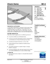
9. ALL BUILDING PADS SLOPED TOWARD THE DRIVEWAY SHALL HAVE<br />
VELOCITY CHECK DAMS PROVIDED AT THE BASE OF DRIVEWAYS DRAINING<br />
INTO THE STREET.<br />
10. GRAVEL BAGS AND NECESSARY MATERIALS IN ACCORDANCE WITH THE<br />
APPROVED PLANS, SHALL BE AVAILABLE ON SITE AND STOCKPILED AT<br />
CONVENIENT LOCATIONS TO FACILITATE RAPID CONSTRUCTION OF<br />
-7-
TEMPORARY DEVICES OR TO REPAIR ANY DAMAGED EROSION CONTROL<br />
MEASURES.<br />
11. STORM DRAIN INLET PROTECTION SHALL BE PROVIDED AT EVERY STORM<br />
DRAIN INLET TO PREVENT SEDIMENT FROM ENTERING THE STORM DRAIN<br />
SYSTEM. DESILTING BASINS SHALL ALSO BE PROVIDED AT DRAINAGE<br />
OUTLETS FROM THE GRADED SITE.<br />
12. VELOCITY CHECK DAMS MADE OF GRAVEL BAGS, STRAW BALES, ETC.,<br />
SHALL BE PROVIDED AT REGULAR INTERVALS IN UNPAVED STREETS, AT<br />
RIGHT ANGLES TO THE CENTERLINE.<br />
13. ALL UNPAVED GRADED CHANNELS SHALL BE PROVIDED WITH VELOCITY<br />
CHECK DAMS AT REGULAR INTERVALS, UNLESS CHANNELS ARE LINED WITH<br />
TEMPORARY MATERIALS SUCH AS PLASTIC SHEETING.<br />
14. ALL REMOVABLE PROTECTION DEVICES SHALL BE IN PLACE, ALL UTILITY<br />
TRENCHES BACKFILLED AND GRAVEL BAGS SHALL BE STOCKPILED ON SITE.<br />
AFTER EACH RAINSTORM, SILT AND DEBRIS SHALL BE REMOVED FROM THE<br />
CHECK DAMS AND DESILTING BASINS. ALL EROSION CONTROL DEVICES<br />
SHALL BE RESTORED TO GOOD WORKING ORDER.<br />
15. PERIMETER EROSION CONTROL MEASURES SHALL BE IN PLACE PRIOR TO<br />
ISSUANCE OF THE GRADING PERMIT.<br />
COMMENTS:<br />
1. ____________________________________________________________________________<br />
____________________________________________________________________________<br />
____________________________________________________________________________<br />
2. ____________________________________________________________________________<br />
____________________________________________________________________________<br />
____________________________________________________________________________<br />
____________________________________________________________________________<br />
3. ____________________________________________________________________________<br />
____________________________________________________________________________<br />
____________________________________________________________________________<br />
-8-
Engineering Department<br />
GRADING & EROSION CONTROL PLAN<br />
Transmittal ~ Re-Submittal Requirements<br />
Date: <strong>City</strong> <strong>Plan</strong> <strong>Check</strong>er: <strong>Check</strong> #:<br />
Project #: Project Name:<br />
THE FOLLOWING INDICATED ITEMS MUST BE INCLUDED IN EACH RE-SUBMITTAL:<br />
Transmittal letter from the Engineer or Surveyor <strong>of</strong> Work listing all the items being submitted.<br />
Copy <strong>of</strong> this <strong>City</strong> Transmittal.<br />
Six (6) bond sets <strong>of</strong> the corrected grading and erosion control plans, folded to 9” x 12”.<br />
Two (2) sets <strong>of</strong> bound (not notebook) corrected Drainage Report, sealed & signed by Eng. or Surveyor <strong>of</strong> Work.<br />
Two (2) sets <strong>of</strong> bound (not notebook) corrected Soils Report, sealed & signed by Engineer or Surveyor <strong>of</strong> Work.<br />
Two (2) sets <strong>of</strong> corrected Engineer’s Cost Estimate, sealed & signed by Engineer or Surveyor <strong>of</strong> Work.<br />
Two (2) sets <strong>of</strong> Stormwater Pollution Prevention <strong>Plan</strong> (SWPPP), corrected as necessary.<br />
All previous checkprints <strong>of</strong> plans, correction list, reports, calculations and estimates.<br />
Concurrent re-submittal: Tract/Parcel Map, Improvement <strong>Plan</strong>s.<br />
Additional Items/Information Required:<br />
Comments:<br />
THE FOLLOWING INDICATED ITEMS MUST BE INCLUDED BEFORE CITY APPROVAL:<br />
Transmittal letter from the Engineer or Surveyor <strong>of</strong> Work listing all the items being submitted.<br />
Copy <strong>of</strong> this <strong>City</strong> Transmittal.<br />
Digital copy <strong>of</strong> plans on CD.<br />
All previous checkprints <strong>of</strong> plans, correction list, reports, calculations and estimates.<br />
Six (6) bond sets <strong>of</strong> the corrected grading and erosion control plan folded to 9”x12”.<br />
Original mylars <strong>of</strong> the plans with all required signatures.<br />
Mylars must also be sealed & signed by the Engineer <strong>of</strong> Work.<br />
Pro<strong>of</strong> <strong>of</strong> approval <strong>of</strong> securities and agreements, and verification <strong>of</strong> payment <strong>of</strong> balance <strong>of</strong> fees.<br />
Additional Items/Information Required:<br />
Comments:<br />
-9-