App G (VIA)part2 - Eskom
App G (VIA)part2 - Eskom
App G (VIA)part2 - Eskom

You also want an ePaper? Increase the reach of your titles
YUMPU automatically turns print PDFs into web optimized ePapers that Google loves.
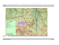
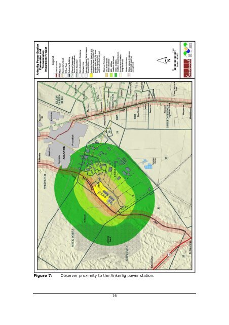
Figure 7: Observer proximity to the Ankerlig power station.<br />
16
Figure 8: Observer proximity to the proposed Ankerlig - Omega transmission<br />
power line.<br />
4.4. Viewer incidence and viewer perception<br />
17
The number of observers and their perception of a structure determine the concept<br />
of visual impact. If there are no observers or if the visual perception of the structure<br />
is favourable to all the observers, there would be no visual impact.<br />
It is necessary to identify areas of high viewer incidence and to classify certain areas<br />
according to the observer's visual sensitivity towards the proposed infrastructure. It<br />
would be impossible not to generalise the viewer incidence and sensitivity to some<br />
degree, as there are many variables when trying to determine the perception of the<br />
observer (i.e. regularity of sighting, cultural background, state of mind, purpose of<br />
sighting, etc.) that would create a myriad of options.<br />
For the purpose of the power station conversion, five areas were classified as having<br />
differing observer incidences and perceptions.<br />
The first area of viewer incidence and perception is indicated as a 200m buffer zone<br />
around the major roads in the area (see Figure 7). The rationale is that this area is<br />
likely to contain the most observers, being the main roads between Cape Town and<br />
the West Coast National Park and Cape Town and Atlantis/Mamre. The purpose of<br />
observers travelling along the R27 would be predominantly tourism related, whilst<br />
observers using the R307 or R304 would more than likely be local residents<br />
commuting between Cape Town and Atlantis/Mamre. If the proposed converted<br />
power station and additional infrastructure were sighted from this area it would more<br />
than likely have a negative impact on the viewer.<br />
The second area of high viewer incidence and negative viewer perception is the<br />
Atlantis residential area. This area has, through its relatively close proximity to the<br />
power station, and through its relatively high population density, the potential to be<br />
visually affected by the proposed OCGT to CCGT conversion. Please refer to Figure<br />
2.<br />
The less populated agricultural areas (agricultural holdings and small holdings west<br />
of the R304) to the east of the study area constitute the third zone. These areas<br />
are sparsely populated but would still evoke a predominantly negative viewer<br />
perception.<br />
The fourth zone is the Atlantis industrial area itself. Employees of the various<br />
industries found within this area predominantly frequent this zone. It is assumed<br />
that their perception of the proposed CCGT plant would be neutral as they go about<br />
their daily business, or even positive for the employees of the facility.<br />
The fifth area is the remainder of the study area (excluding the first four zones).<br />
This area is predominantly devoid of observers, as it covers great tracts of vacant<br />
farming land and unpopulated areas. This zone is seen as having a neutral viewer<br />
perception and therefore a low effect on the visual impact of the proposed facility.<br />
The transmission power line alternatives largely traverse areas with land-uses as<br />
described above (fifth area of viewer incidence or viewer perception). They also<br />
share the characteristics of the first area as discussed above (i.e. a 200m buffer<br />
zone around the major roads) as well as the inclusion of additional sensitive visual<br />
receptors in the form of individual homesteads along the length of the alignments.<br />
These sensitive visual receptors include the farm settlements of Witdam, Vaatjie, Die<br />
Anker, Donkergat, Kleine Zoute Rivier and Brakfontein as indicated on Figure 8.<br />
18
5. RESULTS<br />
5.1. Visual impact index<br />
The combined results of the visual exposure, viewer incidence/perception and visual<br />
distance of the proposed infrastructure are displayed on Figures 9 (power station<br />
conversion) and Figure 10 (transmission power line). Here the weighted impact and<br />
the likely areas of impact are indicated as a visual impact index. Values were<br />
assigned for each potential visual impact per data category (as mentioned above)<br />
and merged in order to calculate the visual impact index. An area with short<br />
distance visual exposure of the project infrastructure, a high viewer incidence and a<br />
predominantly negative perception of the structures would therefore have a higher<br />
value (greater impact) on the index.<br />
Ankerlig Power Station conversion<br />
The proposed OCGT to CCGT conversion and additional infrastructure have the<br />
greatest potential to visually impact on road users travelling along the Dassenberg<br />
Road (R307). This is due to the observer's short distance (and high frequency)<br />
experience of the power station infrastructure. The facility is highly unlikely to be<br />
visible from the Atlantis residential area, but its residents travelling along the R307<br />
would be able to view this infrastructure as they commute to and from Cape Town<br />
and other areas on a daily basis. Existing infrastructure, associated with the OCGT<br />
power station, is already visible from this road (mitigating the potential future visual<br />
impact to some degree) but is set back from the road at a distance of approximately<br />
300m. The additional infrastructure will be placed adjacent to this road at distances<br />
closer than 150m from observers travelling along this road.<br />
The other areas, further removed from the power station, that will experience a<br />
diminishing visual impact of the facility, are virtually all restricted to the industrial<br />
area itself or to predominantly vacant land north-west of the facility. Some of the<br />
smallholdings west of the R304 appear on the lower end of the index where these<br />
sightings will occur at an average distance of approximately 5km.<br />
Transmission power line<br />
The visual impact index for the transmission power line alternatives is shown on<br />
Figure 10. Here the area of potentially high visual impact is indicated within a 500m<br />
buffer zone from the transmission power line. This area (predominantly vacant<br />
farmland) is however greatly devoid of random observers upon whom the<br />
transmission power line could have a visual impact.<br />
Other areas with a very high visual impact value occur along the R27, near Koeberg,<br />
and the R303 near the Omega substation. The sightings of the proposed Ankerlig -<br />
Omega transmission power line along the R27 will be influenced/obstructed by the<br />
existing transmission power line infrastructure (Atlantis-Koeberg 1 and 2, and<br />
Koeberg-Stikland 1), virtually negating the potential visual impact. This is also true<br />
for the proposed sub-alternative section near Koeberg where a great number of<br />
existing power lines exit the power station and cross over the R27. The section<br />
where the proposed transmission power line crosses the R303, approximately 500m<br />
from where the Koeberg-Stikland 1 lines cross the road, will experience the highest<br />
visual impact. The visual impact will be compounded by the additional line crossing<br />
over the road.<br />
19
Most of the farm settlements (as identified from the 1:50 000 topo-cadastral maps)<br />
are not expected to experience high visual impacts. The sensitive visual receptor<br />
indicated as Vaatjie on the map, may experience a medium visual impact (from<br />
approximately 1.5km from the alignment) while most of the other identified<br />
farmsteads (Witdam, Die Anker, Donkergat and Brakfontein) are located beyond two<br />
kilometres from the proposed power line.<br />
The Kleine Zoute Rivier settlement area is expected to experience the highest<br />
potential visual impact as the proposed transmission power line alternatives<br />
effectively traverse these properties. This is especially true for the proposed subalternative<br />
that will span across a number of residences and slightly less so for the<br />
preferred alternative that will cross between the residential dwellings. The<br />
proposed sub-alternative is not considered a viable option to the preferred<br />
alternative due to this potentially critical flaw.<br />
20
Figure 9: Visual impact index - Ankerlig power station conversion.<br />
21
Figure 10: Visual impact index - transmission power line.<br />
22
Figure 11: Koeberg-Stikland 1 transmission power lines crossing the R303 near<br />
the Omega substation. (The proposed Ankerlig - Omega transmission<br />
power line will cross approximately 500m from this point.)<br />
5.2. Visual impact severity rating<br />
The previous section of the report identified specific areas where likely visual impacts<br />
could occur. This section quantifies these potential visual impacts in their respective<br />
geographical locations and in terms of the identified issues related to visual impact.<br />
The methodology for the assessment of potential visual impacts states the nature of<br />
the potential visual impact (e.g. the potential visual impact of the power station<br />
conversion on users of the Dassenberg Road) and includes a table quantifying the<br />
potential visual impact according to the following criteria:<br />
• Extent (E) - local (high = 4), regional (medium = 3), national (low = 2) or<br />
international (very low = 1)<br />
• Duration (D) - very short (0-1 yrs = 1), short (2-5 yrs = 2), medium (5-15<br />
yrs = 3), long (>15 yrs = 4), and permanent (= 5)<br />
• Magnitude (M) - low (= 0-4), medium/moderate (= 4-6), high (= 6-8) and<br />
very high (= 8-10)<br />
• Probability (P) - very improbable (= 1), improbable (= 2), probable (= 3),<br />
highly probable (= 4) and definite (= 5)<br />
• Status (positive, negative or neutral)<br />
• Significance (S) - low, medium or high, where the significance is<br />
determined by combining the above criteria in the following formula: S =<br />
(E+D+M) P<br />
The significance weighting for each potential visual impact (as calculated above) is as<br />
follows:<br />
•
• 31-60 points: Medium (where the impact could influence the decision to<br />
develop in the area)<br />
• >60: High (where the impact must have an influence on the decision to<br />
develop in the area)<br />
The potential visual impact of the power station conversion on users of<br />
Dassenberg Road<br />
As indicated above, the primary area of potential visual impact would occur along<br />
this section of road within a 200m radius of the power station conversion and<br />
additionally constructed infrastructure. It must however be borne in mind that the<br />
visual impact associated with the power station conversion will be an additional<br />
impact and that the initial visual impact has already occurred during the construction<br />
of the original OCGT power plant and its associated infrastructure. This initial visual<br />
impact was further compounded by the capacity increase (i.e. the construction of<br />
additional OCGT units) as addressed by a previous visual impact assessment report<br />
(MetroGIS (Pty) Ltd, 2007).<br />
The envisaged visual impact of the power station conversion and the construction of<br />
additional fuel storage tanks, as well as the proposed water reservoir are therefore<br />
not as significant as would be the case if this had been a "green fields" development<br />
site. The increase in power generating developments along the Dassenberg Road is<br />
however still expected to increase the cumulative visual impact on observers<br />
travelling past the facility, as more structures would be visible along a longer stretch<br />
of road due to the increased height of the structures (i.e. the 60 m high stacks<br />
associated with the CCGT units) and the additional fuel tanks.<br />
The table below quantifies the potential visual impact of the proposed power station<br />
conversion and construction of ancillary infrastructure.<br />
Table 1: Impact table summarising the significance of visual impacts - power<br />
station conversion.<br />
Nature of Impact:<br />
Potential visual impact on users of Dassenberg road.<br />
Without mitigation With mitigation<br />
Extent Local (4) Local (4)<br />
Duration Long term (4) Long term (4)<br />
Magnitude High (7) High (6)<br />
Probability Highly probable (4) Highly probable (4)<br />
Significance High (60) Medium (56)<br />
Status (positive or<br />
negative)<br />
Negative Negative<br />
Reversibility None None<br />
Irreplaceable loss of<br />
resources?<br />
No No<br />
Can impacts be<br />
mitigated?<br />
Mitigation:<br />
Yes (partially) NA<br />
• Additional infrastructure (such as the water reservoir and fuel storage tanks)<br />
should be set back (further away) from the road as far as possible.<br />
• The viability of the construction of a five to ten metre tall vegetated screening<br />
berm between the Dassenberg Road and the power station site (as proposed in the<br />
OCGT capacity increase <strong>VIA</strong> report) should be investigated.<br />
24
Cumulative impacts:<br />
Each new development, expansion or increase in dimensions of the power station<br />
infrastructure attributes to the accumulation of the visual impact of the facility along the<br />
Dassenberg Road.<br />
Residual impacts:<br />
N.A.<br />
The potential visual impact of the transmission power line<br />
The potential visual impact of the construction of the Ankerlig - Omega transmission<br />
power line is generally envisaged to be relatively low. This is due to the transmission<br />
alignment adjacent to the existing power lines within the study area. The already<br />
visible power lines (existing vertical disturbance) are expected to absorb the visual<br />
exposure of an additional power line to a large degree. To this end the proposed<br />
sub-alternative, near the Koeberg power station would have been preferred in order<br />
to confine the exposure of the transmission power line within an already disturbed<br />
development corridor. The originally preferred alternative would spread the visual<br />
exposure and would effectively sterilise (encapsulate) this triangular section created<br />
between the power lines from a visual point of view. The location of the Kleine Zoute<br />
Rivier settlement immediately in the path of this alignment however excludes the<br />
sub-alternative as a viable option.<br />
The areas with the highest envisaged visual impact along the transmission line<br />
alignment are expected to occur near the Omega substation, where the power line<br />
would cross the R303, and at the Kleine Zoute Rivier settlement. Observers<br />
travelling north along the R303 will pass underneath existing transmission power<br />
lines (Koeberg-Stikland 1) and after approximately 500m will encounter the Ankerlig<br />
-Omega power line. The repetitive observation of power lines along this section of<br />
road is therefore spread out over a longer distance thereby increasing the visual<br />
impact. The proposed transmission power line should ideally have crossed the R303<br />
adjacent to the existing power lines.<br />
This realignment of the power line is virtually the only mitigation measure offered for<br />
the construction of the proposed Ankerlig - Omega transmission power line and is<br />
reflected in the table below under the "with mitigation" column.<br />
Table 2: Impact table summarising the significance of visual impacts - Ankerlig<br />
- Omega transmission power line.<br />
Nature of Impact:<br />
Potential visual impact on users of the R303<br />
Without mitigation With mitigation<br />
Extent Local (4) Local (4)<br />
Duration Long term (4) Long term (4)<br />
Magnitude Moderate (5) Moderate (5)<br />
Probability Highly probable (4) Probable (3)<br />
Significance Medium (52) Medium (39)<br />
Status (positive or<br />
negative)<br />
Negative Negative<br />
Reversibility None None<br />
Irreplaceable loss of<br />
resources?<br />
No No<br />
Can impacts be<br />
mitigated?<br />
Yes (partially) NA<br />
25
Mitigation:<br />
The realignment of the preferred alignment to facilitate the crossing of the R303 adjacent<br />
to (in closer proximity to) the existing power lines, should this be technically feasible.<br />
Cumulative impacts:<br />
The construction of each new power line across this road contributes to the potential<br />
cumulative visual impact experienced by road users. Setting the new power lines further<br />
apart spreads the visual impact over a larger distance.<br />
Residual impacts:<br />
N.A.<br />
Table 3: Impact table summarising the significance of visual impacts - Ankerlig<br />
- Omega transmission power line.<br />
Nature of Impact:<br />
Potential visual impact on residents of the Kleine Zoute Rivier settlement associated with<br />
the preferred alternative.<br />
Without mitigation With mitigation<br />
Extent Local (4) NA<br />
Duration Long term (4) NA<br />
Magnitude Very high (8) NA<br />
Probability Highly probable (4) NA<br />
Significance High (64) NA<br />
Status (positive or<br />
negative)<br />
Negative NA<br />
Reversibility None NA<br />
Irreplaceable loss of<br />
resources?<br />
No NA<br />
Can impacts be<br />
mitigated?<br />
Mitigation:<br />
None.<br />
Cumulative impacts:<br />
No NA<br />
The construction of each new power line in close proximity of this settlement contributes to<br />
the potential cumulative visual impact experienced by its residents.<br />
Residual impacts:<br />
NA<br />
Table 4: Impact table summarising the significance of visual impacts - Ankerlig<br />
- Omega transmission power line.<br />
Nature of Impact:<br />
Potential visual impact on residents of the Kleine Zoute Rivier settlement associated with<br />
the sub-alternative.<br />
Without mitigation With mitigation<br />
Extent Local (4) NA<br />
Duration Long term (4) NA<br />
Magnitude Very high (10) NA<br />
Probability Definite (5) NA<br />
Significance Very High (90) NA<br />
Status (positive or<br />
negative)<br />
Negative NA<br />
Reversibility None NA<br />
Irreplaceable loss of<br />
resources?<br />
No NA<br />
26
Can impacts be<br />
mitigated?<br />
Mitigation:<br />
None.<br />
Cumulative impacts:<br />
No NA<br />
The construction of each new power line in close proximity of this settlement contributes to<br />
the potential cumulative visual impact experienced by its residents.<br />
Residual impacts:<br />
NA<br />
5.3. Additional issues related to the visual impact<br />
Landscape character/land use character<br />
The proposed site for the power station conversion is located on the existing Ankerlig<br />
Power Station site within an established industrial area relatively far removed from<br />
residential developments or other conflicting land uses. The general land use is<br />
conducive to the conversion to, and operation of the CCGT plant and no significant<br />
impact on the general land use character of the greater area is envisaged.<br />
The construction of the Ankerlig - Omega transmission power line adjacent to<br />
existing power lines (i.e. an existing vertically disturbed landscape) is similarly not in<br />
conflict with the landscape character.<br />
Visually sensitive features (scenic features or attractions)<br />
The area in close proximity of the proposed power station conversion project and the<br />
transmission power line does not contain any identified visually sensitive features or<br />
scenic attractions. Long distance views of Table Mountain may however be<br />
influenced by the project structures, depending on the location of the viewer in<br />
relation to the power station.<br />
Potential impact of the project infrastructure on tourism and eco-tourism<br />
The specific area surrounding Atlantis and the proposed project infrastructure is not<br />
currently viewed as a major tourist destination. Tourism predominantly consists of<br />
visitors travelling to the West Coast National Park and Saldanha Bay along the R27.<br />
This road passes south-west of the Atlantis industrial area at a distance of about 4km<br />
(at the closest) from the power station.<br />
The conversion of the OCGT plant and the proposed transmission line are not<br />
expected to significantly influence the tourism potential within the region.<br />
Visual absorption capacity (VAC) of the natural vegetation<br />
The visual absorption capacity of the natural vegetation in this region is not<br />
considered as an element that could successfully negate or mitigate the visual<br />
impact of the proposed OCGT to CCGT conversion due to the relatively low growth<br />
form and the height of the proposed conversion infrastructure (i.e. 60m stacks).<br />
Potential visual impact of lighting<br />
27
The effects of lighting are especially problematic in rural or sparsely populated areas<br />
where there is an absence of the lighting generally present in urban areas. The<br />
increase in the number of operational and security lighting fixtures, associated with<br />
the power station conversion project (and the aircraft warning lights required by the<br />
Civil Aviation Authority on the 60m high smoke stacks) may potentially impact on<br />
adjacent landowners north of the Dassenberg Road (i.e. Melkpost). This area north<br />
of the power station site is however not densely populated, with the exception of<br />
Melkpost (which is situated almost 1.5km from the site) and is not expected to<br />
experience significant lighting impacts.<br />
Glare from floodlights has the potential to visually impact, or at the very least<br />
irritate, observers travelling along Dassenberg Road at night if not fitted properly.<br />
The impacts associated with light pollution can be lessened through the careful<br />
planning and sensitive placement of light fixtures and the fitment of covers and<br />
shields designed to contain, rather than spread the light. A qualified lighting<br />
engineer should be consulted during the design and construction phases of the OCGT<br />
to CCGT technology conversion, to plan and fit new lighting fixtures effectively from<br />
the outset.<br />
Potential mitigation measures<br />
The above recommendation (regarding lighting) is an example of a potential<br />
mitigation measure that could diminish the visual impact of the proposed OCGT to<br />
CCGT conversion.<br />
Other potential mitigation measures for the proposed CCGT plant include the<br />
maintenance and general appearance of the facility. These measures focus on the<br />
fact that if/when the facility is seen by outsiders; the general impression should be<br />
favourable. Timely maintenance of the CCGT units, ancillary infrastructure and the<br />
general surrounds of the property (gardens, access roads, etc.) can prevent the<br />
visual impact of degradation and perceived poor management. The most notable<br />
aspect of maintenance on this type of structure is the painting of the CCGT units. In<br />
this regard and as a further mitigation to the visual impact, overtly contrasting and<br />
bright colours should be avoided. Natural hues that compliment the natural<br />
environment can soften the general appearance of the power plant. The colour<br />
schemes currently utilised for the OCGT units is deemed appropriate and should be<br />
continued for the CCGT units and associated infrastructure.<br />
It was also previously noted that the ancillary project infrastructure (i.e. the water<br />
reservoir and fuel storage tanks) should be removed from the Dassenberg Road as<br />
far as possible. The technical feasibility of this suggestion should be investigated<br />
when the detailed site layout plans are compiled for the Ankerlig conversion project.<br />
This will assist in minimising the cumulative visual impact associated with the<br />
additional infrastructure proposed for the power station site.<br />
Mention was also made of the vegetated screening berm that was proposed during<br />
the visual impact assessment for the Ankerlig capacity increase project. The<br />
effectiveness of this screening berm along the northern perimeter of the power<br />
station site was illustrated for the OCGT stacks at an offset of 30m above ground<br />
level. The increase in the stack heights to 60m above ground level will reduce the<br />
effectiveness of the berm to some extent in shielding observers travelling along<br />
28
Dassenberg Road from viewing them. The proposed berm would however still be<br />
effective in hiding the ancillary infrastructure.<br />
Mitigation measures for the proposed Ankerlig - Omega power line include avoiding<br />
the unnecessary removal of vegetation for the transmission power line servitude and<br />
limiting access to the servitude (during both construction and operational phases)<br />
along existing access roads.<br />
6. CONCLUSION<br />
In both the conversion of the power station and construction of the Ankerlig - Omega<br />
transmission power line, the visual impacts will be additional to existing visual<br />
impacts. The operation of the Ankerlig OCGT power station and the number of<br />
transmission power lines already present within the study area mitigates the visual<br />
impacts that would be associated with "green fields" projects. The establishment of<br />
the Atlantis industrial area in the mid-1970s and the presence of the Koeberg<br />
Nuclear Power Station have set the trend for industrial style developments within the<br />
region. It is unlikely that this trend would be reversed in the foreseeable future and<br />
it is envisaged that the region will come under increasing development pressure,<br />
further impacting on the visual quality of the area.<br />
7. MANAGEMENT PLAN<br />
The management plan tables aim to summarise the key findings of the visual impact<br />
report and to suggest possible management actions in order to mitigate the potential<br />
visual impacts.<br />
Table 4: Management plan - Ankerlig power station conversion and associated<br />
infrastructure.<br />
OBJECTIVE: The mitigation and possible negation of the potential visual impact of the OCGT to<br />
CCGT conversion of the Ankerlig power station and ancillary infrastructure with specific<br />
reference to the potential exposure of the project structures to the Dassenberg Road.<br />
Project<br />
component/s<br />
CCGT gas turbine units, water reservoir, fuel storage tanks and lighting<br />
structures.<br />
Potential Impact The potential exposure to and visual impact on observers travelling along<br />
the Dassenberg Road.<br />
Activity/risk source The viewing of the abovementioned project infrastructure from this road.<br />
Mitigation:<br />
Target/Objective<br />
The shielding of the project infrastructure by means of the creation of a 5-<br />
10m high vegetated berm and the sensitive placement of project<br />
infrastructure in order to not visually impose on road users.<br />
Mitigation: Action/control Responsibility Timeframe<br />
Undertake proper pre-construction <strong>Eskom</strong>/landscape Pre-construction.<br />
planning, including a master plan indicating<br />
site layout, infrastructure placement (away<br />
architect/engineer.<br />
from the Dassenberg Road) and the<br />
potential vegetated berm.<br />
Ensure that proper planning is undertaken<br />
regarding the placement of lighting<br />
structures and that light fixtures only<br />
illuminate areas inside the power station<br />
<strong>Eskom</strong>/lighting<br />
engineer.<br />
29<br />
Construction/Operation.
facility. Undertake regular maintenance of<br />
light fixtures.<br />
Maintain the general appearance of the<br />
facility in an aesthetically pleasing way.<br />
Performance<br />
Indicator<br />
<strong>Eskom</strong><br />
30<br />
Operation.<br />
The effective concealment of the majority of the project infrastructure<br />
from observers travelling along the Dassenberg Road.<br />
Monitoring The monitoring of the condition of the site and infrastructure during the<br />
operational phase of the project.<br />
Table 5: Management plan - Ankerlig - Omega transmission power line.<br />
OBJECTIVE: The mitigation of potential visual impacts caused by the unnecessary removal<br />
(clearing) of vegetation cover for the power line servitude or the creation of new access roads<br />
during the construction phase.<br />
Project<br />
Transmission power line servitude.<br />
component/s<br />
Potential Impact The potential scarring of the landscape due to the creation of cleared cutlines<br />
and new roads/tracks.<br />
Activity/risk source The viewing of the abovementioned cutlines/roads by observers.<br />
Mitigation:<br />
Target/Objective<br />
Minimal disturbance to vegetation cover in close vicinity to the proposed<br />
transmission power line.<br />
Mitigation: Action/control Responsibility Timeframe<br />
Avoid the unnecessary removal of <strong>Eskom</strong>.<br />
Construction/Operation.<br />
vegetation for the transmission power<br />
line servitude and limit access to the<br />
servitude (during both construction and<br />
operational phases) along existing<br />
access roads.<br />
Performance<br />
Indicator<br />
Vegetation cover that remains intact with no visible cutlines, access roads<br />
or erosion scarring in and around the power line servitude.<br />
Monitoring The monitoring of vegetation clearing during the construction and<br />
operational phases of the project.<br />
8. REFERENCES<br />
Chief Director of Surveys and Mapping, varying dates. 1:50 000 Topo-cadastral maps<br />
City of Cape Town, varying dates. 5 m interval contours<br />
MetroGIS (Pty) Ltd, 2005. Atlantis Open Cycle Gas Turbine (OCGT) Plant Visual<br />
Impact Assessment and Site Selection<br />
MetroGIS (Pty) Ltd, 2007. Atlantis Open Cycle Gas Turbine (OCGT) Plant - Proposed<br />
OCGT Capacity Increase Visual Impact Assessment