App G (VIA)part2 - Eskom
App G (VIA)part2 - Eskom
App G (VIA)part2 - Eskom

You also want an ePaper? Increase the reach of your titles
YUMPU automatically turns print PDFs into web optimized ePapers that Google loves.
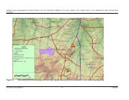
5. RESULTS<br />
5.1. Visual impact index<br />
The combined results of the visual exposure, viewer incidence/perception and visual<br />
distance of the proposed infrastructure are displayed on Figures 9 (power station<br />
conversion) and Figure 10 (transmission power line). Here the weighted impact and<br />
the likely areas of impact are indicated as a visual impact index. Values were<br />
assigned for each potential visual impact per data category (as mentioned above)<br />
and merged in order to calculate the visual impact index. An area with short<br />
distance visual exposure of the project infrastructure, a high viewer incidence and a<br />
predominantly negative perception of the structures would therefore have a higher<br />
value (greater impact) on the index.<br />
Ankerlig Power Station conversion<br />
The proposed OCGT to CCGT conversion and additional infrastructure have the<br />
greatest potential to visually impact on road users travelling along the Dassenberg<br />
Road (R307). This is due to the observer's short distance (and high frequency)<br />
experience of the power station infrastructure. The facility is highly unlikely to be<br />
visible from the Atlantis residential area, but its residents travelling along the R307<br />
would be able to view this infrastructure as they commute to and from Cape Town<br />
and other areas on a daily basis. Existing infrastructure, associated with the OCGT<br />
power station, is already visible from this road (mitigating the potential future visual<br />
impact to some degree) but is set back from the road at a distance of approximately<br />
300m. The additional infrastructure will be placed adjacent to this road at distances<br />
closer than 150m from observers travelling along this road.<br />
The other areas, further removed from the power station, that will experience a<br />
diminishing visual impact of the facility, are virtually all restricted to the industrial<br />
area itself or to predominantly vacant land north-west of the facility. Some of the<br />
smallholdings west of the R304 appear on the lower end of the index where these<br />
sightings will occur at an average distance of approximately 5km.<br />
Transmission power line<br />
The visual impact index for the transmission power line alternatives is shown on<br />
Figure 10. Here the area of potentially high visual impact is indicated within a 500m<br />
buffer zone from the transmission power line. This area (predominantly vacant<br />
farmland) is however greatly devoid of random observers upon whom the<br />
transmission power line could have a visual impact.<br />
Other areas with a very high visual impact value occur along the R27, near Koeberg,<br />
and the R303 near the Omega substation. The sightings of the proposed Ankerlig -<br />
Omega transmission power line along the R27 will be influenced/obstructed by the<br />
existing transmission power line infrastructure (Atlantis-Koeberg 1 and 2, and<br />
Koeberg-Stikland 1), virtually negating the potential visual impact. This is also true<br />
for the proposed sub-alternative section near Koeberg where a great number of<br />
existing power lines exit the power station and cross over the R27. The section<br />
where the proposed transmission power line crosses the R303, approximately 500m<br />
from where the Koeberg-Stikland 1 lines cross the road, will experience the highest<br />
visual impact. The visual impact will be compounded by the additional line crossing<br />
over the road.<br />
19