App G (VIA)part2 - Eskom
App G (VIA)part2 - Eskom
App G (VIA)part2 - Eskom

You also want an ePaper? Increase the reach of your titles
YUMPU automatically turns print PDFs into web optimized ePapers that Google loves.
The number of observers and their perception of a structure determine the concept<br />
of visual impact. If there are no observers or if the visual perception of the structure<br />
is favourable to all the observers, there would be no visual impact.<br />
It is necessary to identify areas of high viewer incidence and to classify certain areas<br />
according to the observer's visual sensitivity towards the proposed infrastructure. It<br />
would be impossible not to generalise the viewer incidence and sensitivity to some<br />
degree, as there are many variables when trying to determine the perception of the<br />
observer (i.e. regularity of sighting, cultural background, state of mind, purpose of<br />
sighting, etc.) that would create a myriad of options.<br />
For the purpose of the power station conversion, five areas were classified as having<br />
differing observer incidences and perceptions.<br />
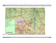
The first area of viewer incidence and perception is indicated as a 200m buffer zone<br />
around the major roads in the area (see Figure 7). The rationale is that this area is<br />
likely to contain the most observers, being the main roads between Cape Town and<br />
the West Coast National Park and Cape Town and Atlantis/Mamre. The purpose of<br />
observers travelling along the R27 would be predominantly tourism related, whilst<br />
observers using the R307 or R304 would more than likely be local residents<br />
commuting between Cape Town and Atlantis/Mamre. If the proposed converted<br />
power station and additional infrastructure were sighted from this area it would more<br />
than likely have a negative impact on the viewer.<br />
The second area of high viewer incidence and negative viewer perception is the<br />
Atlantis residential area. This area has, through its relatively close proximity to the<br />
power station, and through its relatively high population density, the potential to be<br />
visually affected by the proposed OCGT to CCGT conversion. Please refer to Figure<br />
2.<br />
The less populated agricultural areas (agricultural holdings and small holdings west<br />
of the R304) to the east of the study area constitute the third zone. These areas<br />
are sparsely populated but would still evoke a predominantly negative viewer<br />
perception.<br />
The fourth zone is the Atlantis industrial area itself. Employees of the various<br />
industries found within this area predominantly frequent this zone. It is assumed<br />
that their perception of the proposed CCGT plant would be neutral as they go about<br />
their daily business, or even positive for the employees of the facility.<br />
The fifth area is the remainder of the study area (excluding the first four zones).<br />
This area is predominantly devoid of observers, as it covers great tracts of vacant<br />
farming land and unpopulated areas. This zone is seen as having a neutral viewer<br />
perception and therefore a low effect on the visual impact of the proposed facility.<br />
The transmission power line alternatives largely traverse areas with land-uses as<br />
described above (fifth area of viewer incidence or viewer perception). They also<br />
share the characteristics of the first area as discussed above (i.e. a 200m buffer<br />
zone around the major roads) as well as the inclusion of additional sensitive visual<br />
receptors in the form of individual homesteads along the length of the alignments.<br />
These sensitive visual receptors include the farm settlements of Witdam, Vaatjie, Die<br />
Anker, Donkergat, Kleine Zoute Rivier and Brakfontein as indicated on Figure 8.<br />
18