LIDAR - Wikipedia, the free encyclopedia.pdf - Ex-ch.com
LIDAR - Wikipedia, the free encyclopedia.pdf - Ex-ch.com
LIDAR - Wikipedia, the free encyclopedia.pdf - Ex-ch.com

You also want an ePaper? Increase the reach of your titles
YUMPU automatically turns print PDFs into web optimized ePapers that Google loves.
<strong>LIDAR</strong> 1<br />
<strong>LIDAR</strong><br />
<strong>LIDAR</strong> (Light Detection And Ranging) is an optical remote<br />
sensing te<strong>ch</strong>nology that measures properties of scattered light to<br />
find range and/or o<strong>the</strong>r information of a distant target. The<br />
prevalent method to determine distance to an object or surface is to<br />
use laser pulses. Like <strong>the</strong> similar radar te<strong>ch</strong>nology, whi<strong>ch</strong> uses<br />
radio waves, <strong>the</strong> range to an object is determined by measuring <strong>the</strong><br />
time delay between transmission of a pulse and detection of <strong>the</strong><br />
reflected signal. <strong>LIDAR</strong> te<strong>ch</strong>nology has application in Geomatics,<br />
ar<strong>ch</strong>aeology, geography, geology, geomorphology, seismology,<br />
forestry, remote sensing and atmospheric physics. [1] Applications<br />
of <strong>LIDAR</strong> include ALSM (Airborne Laser Swath Mapping), laser<br />
altimetry or <strong>LIDAR</strong> Contour Mapping. The acronym LADAR<br />
(Laser Detection and Ranging) is often used in military contexts.<br />
The term "laser radar" is also in use even though <strong>LIDAR</strong> does<br />
not employ microwaves or radio waves, whi<strong>ch</strong> is definitional to<br />
radar.<br />
General description<br />
The primary difference between <strong>LIDAR</strong> and radar is that <strong>LIDAR</strong><br />
uses mu<strong>ch</strong> shorter wavelengths of <strong>the</strong> electromagnetic spectrum,<br />
typically in <strong>the</strong> ultraviolet, visible, or near infrared range. In<br />
general it is possible to image a feature or object only about <strong>the</strong><br />
same size as <strong>the</strong> wavelength, or larger. Thus lidar is highly<br />
sensitive to aerosols and cloud particles and has many applications<br />
in atmospheric resear<strong>ch</strong> and meteorology [1] .<br />
An object needs to produce a dielectric discontinuity to reflect <strong>the</strong><br />
transmitted wave. At radar (microwave or radio) frequencies, a<br />
metallic object produces a significant reflection. However<br />
non-metallic objects, su<strong>ch</strong> as rain and rocks produce weaker<br />
reflections and some materials may produce no detectable<br />
reflection at all, meaning some objects or features are effectively<br />
invisible at radar frequencies. This is especially true for very small<br />
objects (su<strong>ch</strong> as single molecules and aerosols) [1] .<br />
Lasers provide one solution to <strong>the</strong>se problems. The beam densities<br />
and coherency are excellent. Moreover <strong>the</strong> wavelengths are mu<strong>ch</strong><br />
smaller than can be a<strong>ch</strong>ieved with radio systems, and range from<br />
about 10 micrometers to <strong>the</strong> UV (ca. 250 nm). At su<strong>ch</strong><br />
wavelengths, <strong>the</strong> waves are "reflected" very well from small<br />
objects. This type of reflection is called backscattering. Different<br />
types of scattering are used for different lidar applications, most<br />
<strong>com</strong>mon are Rayleigh scattering, Mie scattering and Raman<br />
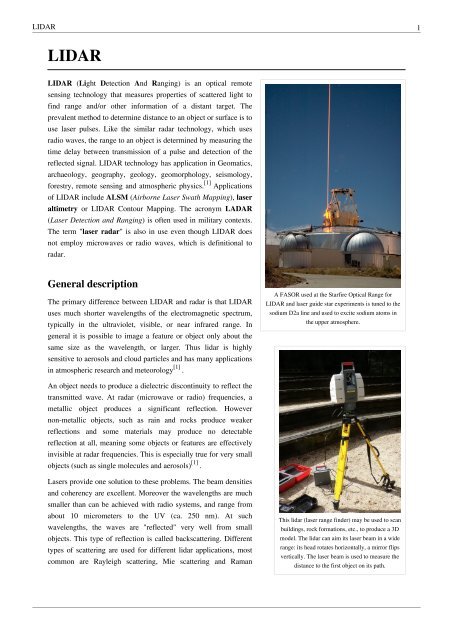
A FASOR used at <strong>the</strong> Starfire Optical Range for<br />
<strong>LIDAR</strong> and laser guide star experiments is tuned to <strong>the</strong><br />
sodium D2a line and used to excite sodium atoms in<br />
<strong>the</strong> upper atmosphere.<br />
This lidar (laser range finder) may be used to scan<br />
buildings, rock formations, etc., to produce a 3D<br />
model. The lidar can aim its laser beam in a wide<br />
range: its head rotates horizontally, a mirror flips<br />
vertically. The laser beam is used to measure <strong>the</strong><br />
distance to <strong>the</strong> first object on its path.
<strong>LIDAR</strong> 2<br />
scattering as well as fluorescence. Based on different kinds of backscattering, <strong>the</strong> <strong>LIDAR</strong> can be accordingly called<br />
Rayleigh LiDAR, Mie LiDAR, Raman LiDAR and Na/Fe/K Fluorescence <strong>LIDAR</strong> and so on. The wavelengths are<br />
ideal for making measurements of smoke and o<strong>the</strong>r airborne particles (aerosols), clouds, and air molecules [1] .<br />
A laser typically has a very narrow beam whi<strong>ch</strong> allows <strong>the</strong> mapping of physical features with very high resolution<br />
<strong>com</strong>pared with radar. In addition, many <strong>ch</strong>emical <strong>com</strong>pounds interact more strongly at visible wavelengths than at<br />
microwaves, resulting in a stronger image of <strong>the</strong>se materials. Suitable <strong>com</strong>binations of lasers can allow for remote<br />
mapping of atmospheric contents by looking for wavelength-dependent <strong>ch</strong>anges in <strong>the</strong> intensity of <strong>the</strong> returned<br />
signal.<br />
<strong>LIDAR</strong> has been used extensively for atmospheric resear<strong>ch</strong> and meteorology. With <strong>the</strong> deployment of <strong>the</strong> GPS in <strong>the</strong><br />
1980s precision positioning of aircraft became possible. GPS based surveying te<strong>ch</strong>nology has made airborne<br />
surveying and mapping applications possible and practical. Many have been developed, using downward-looking<br />
<strong>LIDAR</strong> instruments mounted in aircraft or satellites. A recent example is <strong>the</strong> NASA <strong>Ex</strong>perimental Advanced<br />
Resear<strong>ch</strong> Lidar. [2]<br />
Design<br />
In general <strong>the</strong>re are two kinds of lidar detection s<strong>ch</strong>ema: "incoherent" or direct energy detection (whi<strong>ch</strong> is principally<br />
an amplitude measurement) and Coherent detection (whi<strong>ch</strong> is best for doppler, or phase sensitive measurements).<br />
Coherent systems generally use Optical heterodyne detection whi<strong>ch</strong> being more sensitive than direct detection allows<br />
<strong>the</strong>m to operate a mu<strong>ch</strong> lower power but at <strong>the</strong> expense of more <strong>com</strong>plex transceiver requirements.<br />
In both coherent and incoherent <strong>LIDAR</strong>, <strong>the</strong>re are two types of pulse models: micropulse lidar systems and high<br />
energy systems. Micropulse systems have developed as a result of <strong>the</strong> ever increasing amount of <strong>com</strong>puter power<br />
available <strong>com</strong>bined with advances in laser te<strong>ch</strong>nology. They use considerably less energy in <strong>the</strong> laser, typically on<br />
<strong>the</strong> order of one microjoule, and are often "eye-safe," meaning <strong>the</strong>y can be used without safety precautions.<br />
High-power systems are <strong>com</strong>mon in atmospheric resear<strong>ch</strong>, where <strong>the</strong>y are widely used for measuring many<br />
atmospheric parameters: <strong>the</strong> height, layering and densities of clouds, cloud particle properties (extinction coefficient,<br />
backscatter coefficient, depolarization), temperature, pressure, wind, humidity, trace gas concentration (ozone,<br />
methane, nitrous oxide, etc.) [1] .<br />
There are several major <strong>com</strong>ponents to a <strong>LIDAR</strong> system:<br />
1. Laser — 600-1000 nm lasers are most <strong>com</strong>mon for non-scientific applications. They are inexpensive but since<br />
<strong>the</strong>y can be focused and easily absorbed by <strong>the</strong> eye <strong>the</strong> maximum power is limited by <strong>the</strong> need to make <strong>the</strong>m<br />
eye-safe. Eye-safety is often a requirement for most applications. A <strong>com</strong>mon alternative 1550 nm lasers are<br />
eye-safe at mu<strong>ch</strong> higher power levels since this wavelength is not focused by <strong>the</strong> eye, but <strong>the</strong> detector te<strong>ch</strong>nology<br />
is less advanced and so <strong>the</strong>se wavelengths are generally used at longer ranges and lower accuracies. They are also<br />
used for military applications as 1550 nm is not visible in night vision goggles unlike <strong>the</strong> shorter 1000 nm<br />
infrared laser. Airborne topographic mapping lidars generally use 1064 nm diode pumped YAG lasers, while<br />
bathymetric systems generally use 532 nm frequency doubled diode pumped YAG lasers because 532 nm<br />
penetrates water with mu<strong>ch</strong> less attenuation than does 1064 nm. Laser settings include <strong>the</strong> laser repetition rate<br />
(whi<strong>ch</strong> controls <strong>the</strong> data collection speed). Pulse length is generally an attribute of <strong>the</strong> laser cavity length, <strong>the</strong><br />
number of passes required through <strong>the</strong> gain material (YAG, YLF, etc.), and Q-swit<strong>ch</strong> speed. Better target<br />
resolution is a<strong>ch</strong>ieved with shorter pulses, provided <strong>the</strong> <strong>LIDAR</strong> receiver detectors and electronics have sufficient<br />
bandwidth [1] .<br />
2. Scanner and optics — How fast images can be developed is also affected by <strong>the</strong> speed at whi<strong>ch</strong> it can be<br />
scanned into <strong>the</strong> system. There are several options to scan <strong>the</strong> azimuth and elevation, including dual oscillating<br />
plane mirrors, a <strong>com</strong>bination with a polygon mirror, a dual axis scanner. Optic <strong>ch</strong>oices affect <strong>the</strong> angular<br />
resolution and range that can be detected. A hole mirror or a beam splitter are options to collect a return signal.
<strong>LIDAR</strong> 3<br />
3. Photodetector and receiver electronics — Two main photodetector te<strong>ch</strong>nologies are used in lidars: solid state<br />
photodetectors, su<strong>ch</strong> as silicon avalan<strong>ch</strong>e photodiodes, or photomultipliers. The sensitivity of <strong>the</strong> receiver is<br />
ano<strong>the</strong>r parameter that has to be balanced in a <strong>LIDAR</strong> design.<br />
4. Position and navigation systems — <strong>LIDAR</strong> sensors that are mounted on mobile platforms su<strong>ch</strong> as airplanes or<br />
satellites require instrumentation to determine <strong>the</strong> absolute position and orientation of <strong>the</strong> sensor. Su<strong>ch</strong> devices<br />
generally include a Global Positioning System receiver and an Inertial Measurement Unit (IMU).<br />
Applications<br />
O<strong>the</strong>r than those applications listed above, <strong>the</strong>re are a wide variety of<br />
applications of <strong>LIDAR</strong>, as often mentioned in National <strong>LIDAR</strong> Dataset<br />
programs.<br />
Ar<strong>ch</strong>aeology<br />
<strong>LIDAR</strong> has many applications in <strong>the</strong> field of ar<strong>ch</strong>aeology including<br />
aiding in <strong>the</strong> planning of field campaigns, mapping features beneath<br />
forest canopy [3] , and providing an overview of broad, continuous<br />
features that may be indistinguishable on <strong>the</strong> ground. <strong>LIDAR</strong> can also<br />
provide ar<strong>ch</strong>aeologists with <strong>the</strong> ability to create high-resolution digital<br />
elevation models (DEMs) of ar<strong>ch</strong>aeological sites that can reveal<br />
This <strong>LIDAR</strong>-equipped mobile robot uses its<br />
<strong>LIDAR</strong> to construct a map and avoid obstacles.<br />
micro-topography that are o<strong>the</strong>rwise hidden by vegetation. LiDAR-derived products can be easily integrated into a<br />
Geographic Information System (GIS) for analysis and interpretation. For example at Fort Beausejour - Fort<br />
Cumberland National Historic Site, Canada, previously undiscovered ar<strong>ch</strong>aeological features have been mapped that<br />
are related to <strong>the</strong> siege of <strong>the</strong> Fort in 1755. Features that could not be distinguished on <strong>the</strong> ground or through aerial<br />
photography were identified by overlaying hillshades of <strong>the</strong> DEM created with artificial illumination from various<br />
angles. With LiDAR <strong>the</strong> ability to produce high-resolution datasets quickly and relatively <strong>ch</strong>eaply can be an<br />
advantage. Beyond efficiency, its ability to penetrate forest canopy has led to <strong>the</strong> discovery of features that were not<br />
distinguishable through traditional geo-spatial methods and are difficult to rea<strong>ch</strong> through field surveys. [4]<br />
Meteorology and Atmospheric Environment<br />
The first <strong>LIDAR</strong> systems were used for studies of atmospheric <strong>com</strong>position, structure, clouds, and aerosols. Initially<br />
based on ruby lasers, <strong>LIDAR</strong> for meteorological applications was constructed shortly after <strong>the</strong> invention of <strong>the</strong> laser<br />
and represent one of <strong>the</strong> first applications of laser te<strong>ch</strong>nology.<br />
Elastic backscatter <strong>LIDAR</strong> is <strong>the</strong> simplest type of lidar and is typically used for studies of aerosols and clouds. The<br />
backscattered wavelength is identical to <strong>the</strong> transmitted wavelength, and <strong>the</strong> magnitude of <strong>the</strong> received signal at a<br />
given range depends on <strong>the</strong> backscatter coefficient of scatterers at that range and <strong>the</strong> extinction coefficients of <strong>the</strong><br />
scatterers along <strong>the</strong> path to that range. The extinction coefficient is typically <strong>the</strong> quantity of interest.<br />
Differential Absorption <strong>LIDAR</strong> (DIAL) is used for range-resolved measurements of a particular gas in <strong>the</strong><br />
atmosphere, su<strong>ch</strong> as ozone, carbon dioxide, or water vapor. The <strong>LIDAR</strong> transmits two wavelengths: an "on-line"<br />
wavelength that is absorbed by <strong>the</strong> gas of interest and an off-line wavelength that is not absorbed. The differential<br />
absorption between <strong>the</strong> two wavelengths is a measure of <strong>the</strong> concentration of <strong>the</strong> gas as a function of range. DIAL<br />
<strong>LIDAR</strong>s are essentially dual-wavelength elastic backscatter <strong>LIDAR</strong>S.<br />
Raman <strong>LIDAR</strong> is also used for measuring <strong>the</strong> concentration of atmospheric gases, but can also be used to retrieve<br />
aerosol parameters as well. Raman <strong>LIDAR</strong> exploits inelastic scattering to single out <strong>the</strong> gas of interest from all o<strong>the</strong>r<br />
atmospheric constituents. A small portion of <strong>the</strong> energy of <strong>the</strong> transmitted light is deposited in <strong>the</strong> gas during <strong>the</strong><br />
scattering process, whi<strong>ch</strong> shifts <strong>the</strong> scattered light to a longer wavelength by an amount that is unique to <strong>the</strong> species
<strong>LIDAR</strong> 4<br />
of interest. The higher <strong>the</strong> concentration of <strong>the</strong> gas, <strong>the</strong> stronger <strong>the</strong> magnitude of <strong>the</strong> backscattered signal.<br />
Doppler <strong>LIDAR</strong> is used to measure wind speed along <strong>the</strong> beam by measuring <strong>the</strong> frequency shift of <strong>the</strong> backscattered<br />
light. Scanning <strong>LIDAR</strong>s, su<strong>ch</strong> as NASA's HARLIE <strong>LIDAR</strong>, have been used to measure atmospheric wind velocity<br />
in a large three dimensional cone. [5] ESA's wind mission ADM-Aeolus will be equipped with a Doppler <strong>LIDAR</strong><br />
system in order to provide global measurements of vertical wind profiles. [6] A doppler <strong>LIDAR</strong> system was used in<br />
<strong>the</strong> 2008 Summer Olympics to measure wind fields during <strong>the</strong> ya<strong>ch</strong>t <strong>com</strong>petition. [7] Doppler <strong>LIDAR</strong> systems are<br />
also now beginning to be successfully applied in <strong>the</strong> renewable energy sector to acquire wind speed, turbulence,<br />
wind veer and wind shear data. Both pulsed and continuous wave systems [8] are being used. Pulsed systems using<br />
signal timing to obtain vertical distance resolution, whereas continuous wave systems rely on detector focusing.<br />
Syn<strong>the</strong>tic Array <strong>LIDAR</strong> allows imaging <strong>LIDAR</strong> without <strong>the</strong> need for an array detector. It can be used for imaging<br />
Doppler velocimetry, ultra-fast frame rate (MHz) imaging, as well as for speckle reduction in coherent <strong>LIDAR</strong>. [9]<br />
Wind power<br />
Lidar is sometimes used on wind farms [10] to more accurately measure wind speeds and wind turbulence, and an<br />
experimental [11] lidar is mounted on a wind turbine rotor [12] to measure on<strong>com</strong>ing horizontal winds, and proactively<br />
adjust blades to protect <strong>com</strong>ponents and increase power.<br />
Geology and Soil Science<br />
High-resolution digital elevation maps generated by airborne and stationary <strong>LIDAR</strong> have led to significant advances<br />
in geomorphology, <strong>the</strong> bran<strong>ch</strong> of geoscience concerned with <strong>the</strong> origin and evolution of Earth's surface topography.<br />
<strong>LIDAR</strong>'s abilities to detect subtle topographic features su<strong>ch</strong> as river terraces and river <strong>ch</strong>annel banks, measure <strong>the</strong><br />
land surface elevation beneath <strong>the</strong> vegetation canopy, better resolve spatial derivatives of elevation, and detect<br />
elevation <strong>ch</strong>anges between repeat surveys have enabled many novel studies of <strong>the</strong> physical and <strong>ch</strong>emical processes<br />
that shape landscapes. In addition to <strong>LIDAR</strong> data collected by private <strong>com</strong>panies, academic consortia have been<br />
created to support <strong>the</strong> collection, processing and ar<strong>ch</strong>iving of resear<strong>ch</strong>-grade, publicly available <strong>LIDAR</strong> datasets. The<br />
National Center for Airborne Laser Mapping (NCALM) [13] , supported by <strong>the</strong> National Science Foundation, collects<br />
and distributes <strong>LIDAR</strong> data in support of scientific resear<strong>ch</strong> and education in a variety of fields, particularly<br />
geoscience and ecology.<br />
In geophysics and tectonics, a <strong>com</strong>bination of aircraft-based <strong>LIDAR</strong> and GPS have evolved into an important tool<br />
for detecting faults and measuring uplift. The output of <strong>the</strong> two te<strong>ch</strong>nologies can produce extremely accurate<br />
elevation models for terrain that can even measure ground elevation through trees. This <strong>com</strong>bination was used most<br />
famously to find <strong>the</strong> location of <strong>the</strong> Seattle Fault in Washington, USA. [14] This <strong>com</strong>bination is also being used to<br />
measure uplift at Mt. St. Helens by using data from before and after <strong>the</strong> 2004 uplift. [15] Airborne <strong>LIDAR</strong> systems<br />
monitor glaciers and have <strong>the</strong> ability to detect subtle amounts of growth or decline. A satellite based system is<br />
NASA's ICESat whi<strong>ch</strong> includes a <strong>LIDAR</strong> system for this purpose. NASA's Airborne Topographic Mapper [16] is also<br />
used extensively to monitor glaciers and perform coastal <strong>ch</strong>ange analysis. The <strong>com</strong>bination is also used by soil<br />
scientists while creating a soil survey. The detailed terrain modeling allows soil scientists to see slope <strong>ch</strong>anges and<br />
landform breaks whi<strong>ch</strong> indicate patterns in soil spatial relationships.
<strong>LIDAR</strong> 5<br />
Agriculture<br />
<strong>LIDAR</strong> also can be used to help farmers determine whi<strong>ch</strong> areas of <strong>the</strong>ir<br />
fields to apply costly fertilizer. <strong>LIDAR</strong> can create a topological map of<br />
<strong>the</strong> fields and reveals <strong>the</strong> slopes and sun exposure of <strong>the</strong> farm land.<br />
Resear<strong>ch</strong>ers at <strong>the</strong> Agricultural Resear<strong>ch</strong> Service blended this<br />
topological information with <strong>the</strong> farm land’s yield results from<br />
previous years. From this information, resear<strong>ch</strong>ers categorized <strong>the</strong> farm<br />
land into high-, medium-, or low-yield zones. [17] This te<strong>ch</strong>nology is<br />
valuable to farmers because it indicates whi<strong>ch</strong> areas to apply <strong>the</strong><br />
expensive fertilizers to a<strong>ch</strong>ieve <strong>the</strong> highest crop yield.<br />
Physics and astronomy<br />
A worldwide network of observatories uses lidars to measure <strong>the</strong><br />
Agricultural Resear<strong>ch</strong> Service scientists have<br />
developed a way to incorporate <strong>LIDAR</strong> with<br />
yield rates on agricultural fields. This te<strong>ch</strong>nology<br />
will help farmers direct <strong>the</strong>ir resources toward <strong>the</strong><br />
high-yield sections of <strong>the</strong>ir land.<br />
distance to reflectors placed on <strong>the</strong> moon, allowing <strong>the</strong> moon's position to be measured with mm precision and tests<br />
of general relativity to be done. MOLA, <strong>the</strong> Mars Orbiting Laser Altimeter, used a <strong>LIDAR</strong> instrument in a<br />
Mars-orbiting satellite (<strong>the</strong> NASA Mars Global Surveyor) to produce a spectacularly precise global topographic<br />
survey of <strong>the</strong> red planet.<br />
In September, 2008, NASA's Phoenix Lander used <strong>LIDAR</strong> to detect snow in <strong>the</strong> atmosphere of Mars. [18]<br />
In atmospheric physics, <strong>LIDAR</strong> is used as a remote detection instrument to measure densities of certain constituents<br />
of <strong>the</strong> middle and upper atmosphere, su<strong>ch</strong> as potassium, sodium, or molecular nitrogen and oxygen. These<br />
measurements can be used to calculate temperatures. <strong>LIDAR</strong> can also be used to measure wind speed and to provide<br />
information about vertical distribution of <strong>the</strong> aerosol particles.<br />
At <strong>the</strong> JET nuclear fusion resear<strong>ch</strong> facility, in <strong>the</strong> UK near Abingdon, Oxfordshire, <strong>LIDAR</strong> Thomson Scattering is<br />
used to determine Electron Density and Temperature profiles of <strong>the</strong> plasma. [19]<br />
Biology and conservation<br />
<strong>LIDAR</strong> has also found many applications in forestry. Canopy heights, biomass measurements, and leaf area can all<br />
be studied using airborne <strong>LIDAR</strong> systems. Similarly, <strong>LIDAR</strong> is also used by many industries, including Energy and<br />
Railroad, and <strong>the</strong> Department of Transportation as a faster way of surveying. Topographic maps can also be<br />
generated readily from <strong>LIDAR</strong>, including for recreational use su<strong>ch</strong> as in <strong>the</strong> production of orienteering maps.[20]<br />
In oceanography, LiDAR is used for estimation of phytoplankton fluorescence and generally biomass in <strong>the</strong> surface<br />
layers of <strong>the</strong> ocean. Ano<strong>the</strong>r application is airborne lidar bathymetry of sea areas too shallow for hydrographic<br />
vessels.<br />
In addition, <strong>the</strong> Save-<strong>the</strong>-Redwoods League is undertaking a project to map <strong>the</strong> tall redwoods on California's<br />
nor<strong>the</strong>rn coast. <strong>LIDAR</strong> allows resear<strong>ch</strong> scientists to not only measure <strong>the</strong> height of previously unmapped trees but to<br />
determine <strong>the</strong> biodiversity of <strong>the</strong> redwood forest. Stephen Sillett who is working with <strong>the</strong> League on <strong>the</strong> North Coast<br />
<strong>LIDAR</strong> project claims this te<strong>ch</strong>nology will be useful in directing future efforts to preserve and protect ancient<br />
redwood trees. [21]
<strong>LIDAR</strong> 6<br />
Military and law enforcement<br />
One situation where <strong>LIDAR</strong> has notable non-scientific application is in<br />
traffic speed enforcement, for vehicle speed measurement, as a<br />
te<strong>ch</strong>nology alternative to radar guns. The te<strong>ch</strong>nology for this<br />
application is small enough to be mounted in a hand held camera "gun"<br />
and permits a particular vehicle's speed to be determined from a stream<br />
of traffic. Unlike RADAR whi<strong>ch</strong> relies on doppler shifts to directly<br />
measure speed, police lidar relies on <strong>the</strong> principle of time-of-flight to<br />
calculate speed. The equivalent radar based systems are often not able<br />
to isolate particular vehicles from <strong>the</strong> traffic stream. <strong>LIDAR</strong> has <strong>the</strong><br />
distinct advantage of being able to pick out one vehicle in a cluttered<br />
traffic situation as long as <strong>the</strong> operator is aware of <strong>the</strong> limitations<br />
imposed by <strong>the</strong> range and beam divergence.<br />
Police officer using a hand-held <strong>LIDAR</strong> speed<br />
<strong>LIDAR</strong> does not suffer from “sweep” error when <strong>the</strong> operator uses <strong>the</strong> equipment correctly and when <strong>the</strong> <strong>LIDAR</strong> unit<br />
is equipped with algorithms that are able to detect when this has occurred. A <strong>com</strong>bination of signal strength<br />
monitoring, receive gate timing, target position prediction and pre-filtering of <strong>the</strong> received signal wavelength<br />
prevents this from occurring. Should <strong>the</strong> beam illuminate sections of <strong>the</strong> vehicle with different reflectivity or <strong>the</strong><br />
aspect of <strong>the</strong> vehicle <strong>ch</strong>anges during measurement that causes <strong>the</strong> received signal strength to be <strong>ch</strong>anged <strong>the</strong>n <strong>the</strong><br />
<strong>LIDAR</strong> unit will reject <strong>the</strong> measurement <strong>the</strong>reby producing speed readings of high integrity. For <strong>LIDAR</strong> units to be<br />
used in law enforcement applications a rigorous approval procedure is usually <strong>com</strong>pleted before deployment. The<br />
use of many reflections and an averaging te<strong>ch</strong>nique in <strong>the</strong> speed measurement process increase <strong>the</strong> integrity of <strong>the</strong><br />
speed reading. Vehicles are usually equipped with a horizontally oriented registration plate that, when illuminated,<br />
causes a high integrity reflection to be returned to <strong>the</strong> <strong>LIDAR</strong> - despite <strong>the</strong> shape of <strong>the</strong> vehicle. In locations that do<br />
not require that a front or rear registration plate is fitted, headlamps and rear-reflectors provide almost ideal<br />
retro-reflective surfaces over<strong>com</strong>ing <strong>the</strong> reflections from uneven or non-<strong>com</strong>pliant reflective surfaces <strong>the</strong>reby<br />
eliminating “sweep” error. It is <strong>the</strong>se me<strong>ch</strong>anisms whi<strong>ch</strong> cause concern that <strong>LIDAR</strong> is somehow unreliable.<br />
Most traffic <strong>LIDAR</strong> systems send out a stream of approximately 100 pulses over <strong>the</strong> span of three-tenths of a<br />
second. A "black box" proprietary statistical algorithm picks and <strong>ch</strong>ooses whi<strong>ch</strong> progressively shorter reflections to<br />
retain from <strong>the</strong> pulses over <strong>the</strong> short fraction of a second.<br />
Few military applications are known to be in place and are possibly classified, but a considerable amount of resear<strong>ch</strong><br />
is underway in <strong>the</strong>ir use for imaging. Higher resolution systems collect enough detail to identify targets, su<strong>ch</strong> as<br />
tanks. Here <strong>the</strong> name LADAR is more <strong>com</strong>mon. <strong>Ex</strong>amples of military applications of <strong>LIDAR</strong> include <strong>the</strong> Airborne<br />
Laser Mine Detection System (ALMDS) for counter-mine warfare by Arete Associates [22] .<br />
Utilizing <strong>LIDAR</strong> and THz interferometry wide area raman spectroscopy, it is possible to detect <strong>ch</strong>emical, nuclear, or<br />
biological threats at a great distance. Fur<strong>the</strong>r investigations regarding long distance and wide area spectroscopy are<br />
currently conducted by Sandia National Laboratories.<br />
Five <strong>LIDAR</strong> units produced by <strong>the</strong> German <strong>com</strong>pany Sick AG were used for short range detection on Stanley, <strong>the</strong><br />
autonomous car that won <strong>the</strong> 2005 DARPA Grand Challenge.<br />
A robotic Boeing AH-6 performed a fully autonomous flight in June 2010, including avoiding obstacles using<br />
[23] [24]<br />
<strong>LIDAR</strong>.<br />
gun
<strong>LIDAR</strong> 7<br />
Vehicles<br />
<strong>LIDAR</strong> has been used in Adaptive Cruise Control (ACC) systems for automobiles. Systems su<strong>ch</strong> as those by<br />
Siemens and Hella use a lidar device mounted on <strong>the</strong> front of <strong>the</strong> vehicle, su<strong>ch</strong> as <strong>the</strong> bumper, to monitor <strong>the</strong> distance<br />
between <strong>the</strong> vehicle and any vehicle in front of it. [25] In <strong>the</strong> event <strong>the</strong> vehicle in front slows down or is too close, <strong>the</strong><br />
ACC applies <strong>the</strong> brakes to slow <strong>the</strong> vehicle. When <strong>the</strong> road ahead is clear, <strong>the</strong> ACC allows <strong>the</strong> vehicle to accelerate<br />
to a speed preset by <strong>the</strong> driver.<br />
Imaging<br />
3-D imaging is done with both scanning and non-scanning systems. "3-D gated viewing laser radar" is a<br />
non-scanning laser radar system that applies <strong>the</strong> so-called gated viewing te<strong>ch</strong>nique. The gated viewing te<strong>ch</strong>nique<br />
applies a pulsed laser and a fast gated camera. There are ongoing military resear<strong>ch</strong> programmes in Sweden,<br />
Denmark, <strong>the</strong> USA and <strong>the</strong> UK with 3-D gated viewing imaging at several kilometers range with a range resolution<br />
and accuracy better than ten centimeters.<br />
Coherent Imaging <strong>LIDAR</strong> is possible using Syn<strong>the</strong>tic array heterodyne detection whi<strong>ch</strong> is a form of Optical<br />
heterodyne detection that enables a staring single element receiver to act as though it were an imaging array. [9] This<br />
avoids <strong>the</strong> need for a gated camera and all ranges from all pixels are simultaneously available in <strong>the</strong> image.<br />
Imaging <strong>LIDAR</strong> can also be performed using arrays of high speed detectors and modulation sensitive detectors<br />
arrays typically built on single <strong>ch</strong>ips using CMOS and hybrid CMOS/CCD fabrication te<strong>ch</strong>niques. In <strong>the</strong>se devices<br />
ea<strong>ch</strong> pixel performs some local processing su<strong>ch</strong> as demodulation or gating at high speed down converting <strong>the</strong> signals<br />
to video rate so that <strong>the</strong> array may be read like a camera. Using this te<strong>ch</strong>nique many thousands of pixels / <strong>ch</strong>annels<br />
may be acquired simultaneously. In practical systems <strong>the</strong> limitation is light budget ra<strong>the</strong>r than parallel acquisition.<br />
<strong>LIDAR</strong> has been used in <strong>the</strong> recording of a music video without cameras. The video for <strong>the</strong> song "House of Cards"<br />
by Radiohead is believed to be <strong>the</strong> first use of real-time 3D laser scanning to record a music video. [26]<br />
Aerial Surveying - 3D mapping<br />
Airborne <strong>LIDAR</strong> sensors are used by <strong>com</strong>panies in <strong>the</strong> Remote<br />
Sensing field to create point clouds of <strong>the</strong> earth ground for fur<strong>the</strong>r<br />
processing (e.g. used in forestry). A <strong>com</strong>mon format for saving <strong>the</strong>se<br />
points (with parameters like x, y, return, intensity, elevation) is <strong>the</strong><br />
LAS file format (see libLAS).<br />
.<br />
See also<br />
• Atomic line filter<br />
• CLidar<br />
• Laser rangefinder<br />
• libLAS, a BSD-licensed C++ library for reading/writing ASPRS LAS LiDAR data<br />
• <strong>LIDAR</strong> detector<br />
• National <strong>LIDAR</strong> Dataset<br />
• National <strong>LIDAR</strong> Dataset - USA<br />
• Opte<strong>ch</strong> Incorporated, a <strong>com</strong>pany focusing on lidars<br />
• Optical heterodyne detection<br />
• Optical time domain reflectometer<br />
• Radar<br />
Aerial LiDAR surveying from a paraplane<br />
operated by Scandinavian Laser Surveying
<strong>LIDAR</strong> 8<br />
• Satellite laser ranging<br />
• Sonar<br />
• Time domain reflectometry<br />
• TopoFlight<br />
References<br />
[1] Cracknell, Arthur P.; Hayes, Ladson (2007) [1991]. Introduction to Remote Sensing (2 ed.). London: Taylor and Francis. ISBN 0849392551.<br />
OCLC 70765252<br />
[2] '<strong>Ex</strong>perimental Advanced Resear<strong>ch</strong> Lidar', NASA.org (http:/ / inst. wff. nasa. gov/ eaarl/ ). Retrieved 8 August 2007.<br />
[3] EID; crater beneath canopy (http:/ / www. unb. ca/ passc/ ImpactDatabase/ images/ whitecourt. htm)<br />
[4] John Nobel Wilford (2010-05-10). "Mapping Ancient Civilization, in a Matter of Days" (http:/ / www. nytimes. <strong>com</strong>/ 2010/ 05/ 11/ science/<br />
11maya. html?pagewanted=all). New York Times. . Retrieved 2010-05-11.<br />
[5] Thomas D. Wilkerson, Geary K. S<strong>ch</strong>wemmer, and Bruce M. Gentry. <strong>LIDAR</strong> Profiling of Aerosols, Clouds, and Winds by Doppler and<br />
Non-Doppler Methods, NASA International H2O Project (2002) (http:/ / harlie. gsfc. nasa. gov/ IHOP2002/ Pub& Pats/ AMOS 2002 final.<br />
<strong>pdf</strong>).<br />
[6] 'Earth <strong>Ex</strong>plorers: ADM-Aeolus', ESA.org (European Space Agency, 6 June 2007) (http:/ / www. esa. int/ esaLP/<br />
ESAES62VMOC_LPadmaeolus_0. html). Retrieved 8 August 2007.<br />
[7] 'Doppler lidar gives Olympic sailors <strong>the</strong> edge', Optics.org (3 July, 2008) (http:/ / optics. org/ cws/ article/ resear<strong>ch</strong>/ 34878). Retrieved 8 July<br />
2008.<br />
[8] http:/ / www. naturalpower. <strong>com</strong>/ zephir<br />
[9] Strauss C. E. M., " Syn<strong>the</strong>tic-array heterodyne detection: a single-element detector acts as an array (http:/ / www. opticsinfobase. org/ ol/<br />
abstract. cfm?id=12612)", Opt. Lett. 19, 1609-1611 (1994)<br />
[10] Mikkelsen, Torben et al. 12MW Horns Rev <strong>Ex</strong>periment (http:/ / 130. 226. 56. 153/ rispubl/ reports/ ris-r-1506. <strong>pdf</strong>) Risoe, October 2007.<br />
Retrieved: 25 April 2010.<br />
[11] Smarting from <strong>the</strong> wind (http:/ / www. economist. <strong>com</strong>/ science-te<strong>ch</strong>nology/ te<strong>ch</strong>nology-quarterly/ displaystory. cfm?story_id=15582251)<br />
Economist, 4 Mar<strong>ch</strong> 2010. Retrieved: 25 April 2010.<br />
[12] Mikkelsen, Torben & Hansen, Kasper Hjorth et al. Lidar wind speed measurements from a rotating spinner (http:/ / orbit. dtu. dk/<br />
getResource?recordId=259451& objectId=1& versionId=1) Danish Resear<strong>ch</strong> Database & Danish Te<strong>ch</strong>nical University, 20 April 2010.<br />
Retrieved: 25 April 2010.<br />
[13] http:/ / www. ncalm. org<br />
[14] Tom Paulson. '<strong>LIDAR</strong> shows where earthquake risks are highest, Seattle Post (Wednesday, April 18, 2001) (http:/ / seattlepi. nwsource.<br />
<strong>com</strong>/ local/ 19144_quake18. shtml).<br />
[15] 'Mount Saint Helens <strong>LIDAR</strong> Data', Washington State Geospatial Data Ar<strong>ch</strong>ive (September 13, 2006) (http:/ / wagda. lib. washington. edu/<br />
data/ type/ elevation/ lidar/ st_helens/ ). Retrieved 8 August 2007.<br />
[16] 'Airborne Topographic Mapper', NASA.gov (http:/ / atm. wff. nasa. gov/ ). Retrieved 8 August 2007.<br />
[17] "ARS Study Helps Farmers Make Best Use of Fertilizers" (http:/ / www. ars. usda. gov/ is/ pr/ 2010/ 100609. htm). USDA Agricultural<br />
Resear<strong>ch</strong> Service. June 9, 2010. .<br />
[18] NASA. 'NASA Mars Lander Sees Falling Snow, Soil Data Suggest Liquid Past' NASA.gov (29 September 2008) (http:/ / www. nasa. gov/<br />
mission_pages/ phoenix/ news/ phoenix-20080929. html). Retrieved 9 November 2008.<br />
[19] CW Gowers. ' Focus On : Lidar-Thomson Scattering Diagnostic on JET' JET.EFDA.org (undated) (http:/ / www. jet. efda. org/ pages/ focus/<br />
lidar/ index. html). Retrieved 8 August 2007. Ar<strong>ch</strong>ived (http:/ / web. ar<strong>ch</strong>ive. org/ web/ 20070918224524/ http:/ / www. jet. efda. org/ pages/<br />
focus/ lidar/ index. html) September 18, 2007 at <strong>the</strong> Wayback Ma<strong>ch</strong>ine.<br />
[20] http:/ / www. lidarbasemaps. org<br />
[21] Councillor Quarterly, Summer 2007 Volume 6 Issue 3<br />
[22] http:/ / www. arete. <strong>com</strong>/ index. php?view=stil_mcm<br />
[23] Spice, Byron. Resear<strong>ch</strong>ers Help Develop Full-Size Autonomous Helicopter (http:/ / www. cmu. edu/ news/ blog/ 2010/ Summer/<br />
unprecedented-robo<strong>ch</strong>opper. shtml) Carnegie Mellon, 6 July 2010. Retrieved: 19 July 2010.<br />
[24] Koski, Olivia. In a First, Full-Sized Robo-Copter Flies With No Human Help (http:/ / www. wired. <strong>com</strong>/ dangerroom/ 2010/ 07/<br />
in-a-first-full-sized-robo-copter-flies-with-no-human-help/ ?utm_source=feedburner& utm_medium=feed& utm_campaign=Feed:+ wired/<br />
index+ (Wired:+ Index+ 3+ (Top+ Stories+ 2))#ixzz0tk2hAfAQ) Wired, 14 July 2010. Retrieved: 19 July 2010.<br />
[25] Bumper-mounted lasers (http:/ / www. sciencedaily. <strong>com</strong>/ releases/ 2007/ 02/ 070218131830. htm)<br />
[26] Nick Parish, From OK Computer to Roll <strong>com</strong>puter: Radiohead and director James Frost make a video without cameras, CREATIVITY<br />
(July 13, 2008) (http:/ / creativity-online. <strong>com</strong>/ ?action=news:article& newsId=129514& sectionId=behind_<strong>the</strong>_work).<br />
http:/ / www. sciencegl. <strong>com</strong>/ gis_dem/ index. html de
<strong>LIDAR</strong> 9<br />
<strong>Ex</strong>ternal links<br />
• An Airborne Altimetric LiDAR tutorial (http:/ / home. iitk. ac. in/ ~blohani/ LiDAR_Tutorial/<br />
Airborne_AltimetricLidar_Tutorial. htm). A tutorial on altimetric LiDAR.<br />
• NASA <strong>Ex</strong>perimental Advanced Airborne Resear<strong>ch</strong> Lidar (http:/ / inst. wff. nasa. gov/ eaarl/ ). NASA's EAARL is<br />
an airborne Lidar designed to map <strong>com</strong>plex coastal environments above and below <strong>the</strong> water, within vegetated<br />
areas. It is also being used to map <strong>the</strong> bottom topography is shallow braided rivers and streams.<br />
• CALIPSO (http:/ / www-calipso. larc. nasa. gov/ ): The Cloud-Aerosol Lidar and Infrared Pathfinder Satellite<br />
Observation satellite—space-based laser remote sensing of clouds and aerosols for a better understanding of<br />
climate <strong>ch</strong>ange issues<br />
• NCAR REAL (http:/ / www. eol. ucar. edu/ lidar): NCAR's Earth Observing Laboratory (EOL) created <strong>the</strong><br />
Raman-shifted Eyesafe Aerosol Lidar. This eyesafe high energy lidar with scanning capability expands <strong>the</strong><br />
applications to include mapping urban atmospheric pollutants and studies of dispersion very near <strong>the</strong> surface of<br />
<strong>the</strong> earth.<br />
• NOAA Oceanographic (Fish) Lidar (http:/ / www. etl. noaa. gov/ te<strong>ch</strong>nology/ instruments/ floe/ )<br />
• Joint Airborne Lidar Bathymetry Te<strong>ch</strong>nical Center of <strong>Ex</strong>pertise (JALBTCX) (http:/ / shoals. sam. usace. army.<br />
mil/ )<br />
• EOSL (http:/ / eosl. gtri. gate<strong>ch</strong>. edu/ index. jsp) - The Electro-Optical Systems Laboratory at GTRI has a<br />
nationally known program in lidar resear<strong>ch</strong> and development.<br />
• The NASA Goddard Space Flight Center's Raman Lidar Laboratory (http:/ / ramanlidar. gsfc. nasa. gov) - This<br />
laboratory has a ground and an up<strong>com</strong>ing airborne Raman lidar measuring water vapor, aerosols and o<strong>the</strong>r<br />
atmospheric species<br />
• The USGS Center for <strong>LIDAR</strong> Information Coordination and Knowledge (CLICK) (http:/ / lidar. cr. usgs. gov/ ) -<br />
A website intended to "facilitate data access, user coordination and education of lidar remote sensing for scientific<br />
needs."<br />
• Tutorial slides on <strong>LIDAR</strong> (aerial laser scanning) (http:/ / www. ikg. uni-hannover. de/ fileadmin/ ikg/ staff/<br />
publications/ sonstige_Beitraege/ Brenner_tutorialSommerS<strong>ch</strong>ool2006. <strong>pdf</strong>)<br />
• Weier, John. 2004. Conservation in 3D (http:/ / www. conbio. org/ cip/ article53C3D. cfm). Conservation in<br />
Practice 5(3):39-41. On <strong>the</strong> conservation applications of <strong>LIDAR</strong>.
Article Sources and Contributors 10<br />
Article Sources and Contributors<br />
<strong>LIDAR</strong> Source: http://en.wikipedia.org/w/index.php?oldid=398904114 Contributors: Adraeus, Ams80, AndLang, Andux, Antandrus, ArnoldReinhold, Authalic, Awickert, Ballista, Billylewins,<br />
Bred, Bumbulski, Calrosfing, Cameron Dewe, Cap.fwiffo, CastAStone, Cdc, CharlesC, Clut<strong>ch</strong>world, CommonsDelinker, Craigrosa, DaGizza, Daniel C, David Streutker, David.Monniaux,<br />
Deglr6328, Derek Ross, DiamondDave, Disavian, Doctorlidar, Dougstiff, Dreadstar, Dynaflow, Ehn, Ender8282, Epolk, Esrever, Evolauxia, <strong>Ex</strong>eunt, Femto, Fmeng, Friendly Neighbour, Gene<br />
Nygaard, GenericBob, Gfarrand, Gh5046, Gjs238, Glogger, Gollor, Gracefool, GregorB, Hairy Dude, Hankwang, Heron, Hstyri, Huntster, IanBushfield, J.delanoy, J04n, JamesAM, JamieNettles,<br />
Jaraalbe, Jtgeo, Jthiegs, JuJube, KVDP, Kamocat, Karl-Henner, Kate, Keithh, Koavf, Kozu<strong>ch</strong>, Krash, Kummi, Kvng, Laser.scientist, Lidar532, Loadmaster, Lsauvage, Maniraptor, Margareta,<br />
MarixD, Mattisse, Maunaloaobservatory, Maury Markowitz, Max-B, Maye, Mcgowan30, Mgb wiki, Mi<strong>ch</strong>ael Daly, Midgley, Mikael666, Mike1024, Miskaton, Mm40, MrBell, MrOllie,<br />
Mtownene, Mwtoews, NHSavage, Nahum Reduta, NerdyNSK, Nono64, Novasource, Op. Deo, OrgasGirl, PWdiamond, Pearle, Pedrose, Pflatau, Plrk, Postdlf, Prolog, Pruthvi.Vallabh,<br />
QuantumEleven, Radmap, RisingStick, RiverBed, Rknopman, Rmrfstar, Rwestafer, SD6-Agent, Sam<strong>free</strong>d, Sanders muc, Sardanaphalus, Shaddack, Silivrenion, Slicky, Smack, Socrates2008,<br />
Srleffler, Su-no-G, Systemf, TGCP, Tantalate, Tedernst, The Anome, The Original Wildbear, TheoClarke, Togr, Tom, Tom Greaves, Twang, Verminaard510, Versus22, Volnturista, WakingLili,<br />
Wikiproject1400, Wswaterlily, Wyman2712, Xavier onnasis, Yuriybrisk, 226 anonymous edits<br />
Image Sources, Licenses and Contributors<br />
Image:Starfire Optical Range - sodium laser.jpg Source: http://en.wikipedia.org/w/index.php?title=File:Starfire_Optical_Range_-_sodium_laser.jpg License: unknown Contributors:<br />
Fastfission, HHahn, Herbythyme, Huntster, Mattes, Mike1024, Phillman5, Pieter Kuiper, Siebrand, Tony Wills, <strong>Wikipedia</strong>Master, 13 anonymous edits<br />
Image:Lidar P1270901.jpg Source: http://en.wikipedia.org/w/index.php?title=File:Lidar_P1270901.jpg License: GNU Free Documentation License Contributors: User:David.Monniaux<br />
Image:<strong>LIDAR</strong> equipped mobile robot.jpg Source: http://en.wikipedia.org/w/index.php?title=File:<strong>LIDAR</strong>_equipped_mobile_robot.jpg License: Public Domain Contributors: S. Winkvist<br />
Image:<strong>LIDAR</strong> field yield.jpg Source: http://en.wikipedia.org/w/index.php?title=File:<strong>LIDAR</strong>_field_yield.jpg License: Public Domain Contributors: Huntster, Wikiproject1400<br />
File:Police-<strong>LIDAR</strong>-Gun-0946.jpg Source: http://en.wikipedia.org/w/index.php?title=File:Police-<strong>LIDAR</strong>-Gun-0946.jpg License: Creative Commons Attribution-Sharealike 3.0 Contributors:<br />
User:Loadmaster<br />
File:Paraplane_in_air.png Source: http://en.wikipedia.org/w/index.php?title=File:Paraplane_in_air.png License: Creative Commons Attribution-Sharealike 3.0 Contributors: User:Mikael666<br />
License<br />
Creative Commons Attribution-Share Alike 3.0 Unported<br />
http:/ / creative<strong>com</strong>mons. org/ licenses/ by-sa/ 3. 0/