Baroque Nationalism: Dutch Seascapes, Landscapes and Maps
Baroque Nationalism: Dutch Seascapes, Landscapes and Maps
Baroque Nationalism: Dutch Seascapes, Landscapes and Maps

Create successful ePaper yourself
Turn your PDF publications into a flip-book with our unique Google optimized e-Paper software.
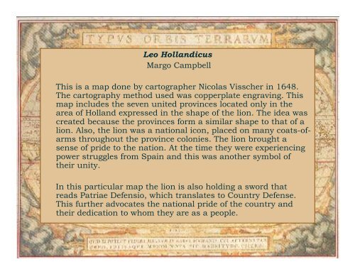
Leo Holl<strong>and</strong>icus<br />
Margo Campbell<br />
This is a map done by cartographer Nicolas Visscher in 1648.<br />
The cartography method used was copperplate engraving. This<br />
map includes the seven united provinces located only in the<br />
area of Holl<strong>and</strong> expressed in the shape of the lion. The idea was<br />
created because the provinces form a similar shape to that of a<br />
lion. Also, the lion was a national icon, placed on many coats-ofarms<br />
throughout the province colonies. The lion brought a<br />
sense of pride to the nation. At the time they were experiencing<br />
power struggles from Spain <strong>and</strong> this was another symbol of<br />
their unity.<br />
In this particular map the lion is also holding a sword that<br />
reads Patriae Defensio, which translates to Country Defense.<br />
This further advocates the national pride of the country <strong>and</strong><br />
their dedication to whom they are as a people.