BIOPHYSICAL REGIONS - Maine.gov
BIOPHYSICAL REGIONS - Maine.gov
BIOPHYSICAL REGIONS - Maine.gov

You also want an ePaper? Increase the reach of your titles
YUMPU automatically turns print PDFs into web optimized ePapers that Google loves.
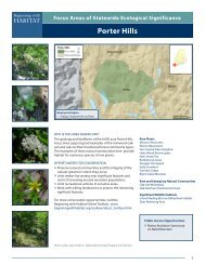
Appendix 7 Biophysical Regions of <strong>Maine</strong><br />
Bay’s east shore and the Muscongus Bay area is predominantly granite. The west shore of<br />
Penobscot Bay and Pemaquid Point are composed of metamorphosed pelites and sandstones.<br />
Metavolcanic rocks are restricted to the Cape Rosier area.<br />
Climate: In most respects, the climate is intermediate between that of the East Coastal and<br />
Midcoast Regions. Although there is a distinct maritime influence, with high annual precipitation<br />
and frequent fog, higher summer temperatures result in a lower moisture surplus than in the<br />
East Coastal Region. Mean maximum temperature in July is 77° F, which is approximately 4°<br />
warmer than the East Coastal Region and slightly cooler than the midcoast. Mean minimum<br />
temperature in January is 11° F, approximately 2° cooler than the East Coastal Region.<br />
Although average annual precipitation (49”) is higher than in any other region, average annual<br />
snowfall (63”) is less than that of the East and Midcoast Regions. This region also has a shorter<br />
growing season (140 days) than abutting coastal regions.<br />
Surficial Geology and Soils: East of Penobscot Bay, higher elevations are generally covered<br />
with thin drift, which provides the parent material for shallow, coarse loamy Lyman soils. West of<br />
Penobscot Bay, upland areas are dominated by deep (> 60”), coarse loamy Tunbridge and<br />
deep, coarse loamy Dixfield soils. Lyman soils, which tend to be somewhat excessively drained,<br />
generally occur on ridge tops, while well and moderately well drained Tunbridge and Dixfield<br />
soils occur on ridge slopes. Coarse-grained, but poorly drained Colonel and Brayton soils are<br />
characteristic of lower ridges and toe slopes. Valleys and lowlands throughout the region are<br />
filled with deep, poorly drained glaciomarine clays and silts.<br />
Vegetation and Flora: The Penobscot Bay Region supports vegetation that is transitional<br />
between the coastal spruce-fir ecosystems of the east and a forest dominated by Pinus strobus<br />
and Quercus rubra to the southwest. Species of northern affinity, such as the distinctive<br />
subarctic maritime flora of the East Coastal Region are present only on offshore islands here.<br />
The coastal spruce-fir forest is no longer continuous; it occurs in small stands on islands and<br />
exposed headlands. Twenty woody species that reach their northern limits in <strong>Maine</strong> or New<br />
Brunswick reach a coastal limit in the eastern portion of the Penobscot Bay Region. These<br />
include Acer saccharinum, Alnus serrulata, Aralia racemosa, Carpinus caroliniana, Carya ovata,<br />
Castanea dentata, Ceanothus americanus, Chamaecyparis thyoides, Fraxinus pennsylvanica,<br />
Juniperus virginiana, Platanus occidentalis, Quercus macrocarpa, Quercus alba, Salix coactilis,<br />
Salix nigra, Salix planifolia, Viburnum lentago, Vitis labrusca, Vitis novae-angliae, and Vitis<br />
riparia. Most of these species are characteristic of warm temperate regions. This represents the<br />
highest concentration of northern range limits along the coast. Along with the southwestern<br />
portion of the East Coastal Region, this portion of the Penobscot Bay Region marks the eastern<br />
end of the transition zone.<br />
East Coastal Region<br />
Physiography: The East Coastal Region parallels the Gulf of <strong>Maine</strong> in a 20 mile wide band that<br />
extends from Mount Desert Island and Isle au Haut east to Passamaquoddy Bay (in the vicinity<br />
of Perry). The region is characterized by low ridges surrounded by poorly drained, relatively flat<br />
terrain. Elevations are generally less than 100’ with the exceptions of the mountains of Mount<br />
Desert Island and the Tunk Lake area, which rise to elevations of 1000’ or more. Topographic<br />
highs occur on plutons of course-grained granitic rocks, while the more easily eroded finergrained<br />
intrusive and metamorphic rocks from Roque Bluffs to East Quoddy Head have been<br />
worn to lower elevations. Bedrock is predominantly igneous, except for outcrops of<br />
metavolcanic rocks near Columbia Falls and in the Cobscook Bay area. Most of the headlands<br />
13