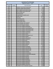
BIOPHYSICAL REGIONS - Maine.gov
BIOPHYSICAL REGIONS - Maine.gov
BIOPHYSICAL REGIONS - Maine.gov

You also want an ePaper? Increase the reach of your titles
YUMPU automatically turns print PDFs into web optimized ePapers that Google loves.
Appendix 7 Biophysical Regions of <strong>Maine</strong><br />
Aroostook Hills Region<br />
Physiography: The Aroostook Hills Region extends from the Saint John River near Madawaska<br />
south to the Patten area. The western boundary is delineated by the 1000’ contour line and the<br />
eastern boundary is defined by the calcareous bedrock and tills that underlie the Aroostook<br />
Lowlands. The region is characterized by gently rolling terrain with elevations averaging<br />
between 800’ and 1000’. Scattered mountains occur in the Winterville area and on a small<br />
pluton north of Shin Pond. Topographic highs include Pennington Mountain (1578’), Green<br />
Mountain (1687’), and Mount Chase (2440’). Unlike the Saint John Uplands and Aroostook<br />
Lowlands, lakes and peatlands are abundant.<br />
Bedrock of the region is almost entirely composed of weakly metamorphosed interbedded<br />
pelites, sandstones, and some limestone. Intrusives include a belt of metavolcanic rock that cuts<br />
across the central portion of the region and the quartz diorite pluton that underlies Mount Chase.<br />
Climate: Except for maximum July temperature, which averages 78° F throughout the region,<br />
climate varies considerably from north to south. Winter temperatures, annual precipitation, and<br />
snowfall are lower in the north. On average, the length of the frost-free season is 20 days<br />
shorter in the central portion of the region than either the north or the south. The average<br />
minimum January temperature ranges from 4° F near Patten to -5° F near Squa Pan. Average<br />
annual precipitation ranges from 43” in Patten to 35” in Squa Pan and average snowfall ranges<br />
from 120” in Patten to 100” in the north. The climate is intermediate between the Saint John<br />
Uplands and the Aroostook Lowlands.<br />
Surficial Geology and Soils: The eastern portion of the region has extensive but scattered<br />
deposits of glaciolacustrine sediments on which cedar swamps and peatlands have developed.<br />
The western portion is covered with thin drift and pockets of deeper till. Shallow (10”-20”)<br />
excessively drained Thorndike silt loams occur on ridge tops, well to moderately well-drained<br />
Plaisted silt loams and Chesuncook loams occur on upper slopes, and finer poorly drained<br />
Aurelie and somewhat poorly drained Daigle soils are typical of valleys in the northern portion of<br />
the region. In the south, shallow course-grained Lyman or fine-grained Monson soils are<br />
characteristic of higher elevations, with somewhat poorly drained Colonel fine sandy loams and<br />
Telos loams below. Deep poorly drained Monarda loams are widespread in the valleys.<br />
Vegetation and Flora: The western boundary of the region coincides with a vegetation transition<br />
zone where species characteristic of temperate regions are replaced by those of more boreal<br />
affinity. In addition to this transition zone, two peatland types, eccentric bogs and concentrically<br />
patterned raised bogs, reach their western limit in <strong>Maine</strong> here. This is apparently a topographic<br />
rather than a climatic limit – the total number and area of peat lands are generally less in<br />
mountainous well-drained terrain. Raised bogs are confined to the limited number of flat basins<br />
that are scattered among the hills and mountains, while eccentric bogs occur on the gentle<br />
slopes rising from these basins. Forest ecosystems are more diverse in the Aroostook Hills<br />
Region than in western portions of Aroostook County.<br />
Aroostook Lowlands Region<br />
Physiography: The Aroostook Lowlands extend from the Saint John River west of Van Buren<br />
south to Linneus. The western boundary coincides with the westward extent of calcareous tills<br />
and bedrock. Elevations are relatively low (approximately 600’ to 800’) except for a few<br />
3