The Eucalypts of the Greater Blue Mountains World Heritage Area ...
The Eucalypts of the Greater Blue Mountains World Heritage Area ...
The Eucalypts of the Greater Blue Mountains World Heritage Area ...

Create successful ePaper yourself
Turn your PDF publications into a flip-book with our unique Google optimized e-Paper software.
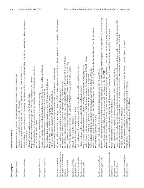
436 Cunninghamia 11(4): 2010 Hager & Benson, <strong>Eucalypts</strong> <strong>of</strong> <strong>the</strong> <strong>Greater</strong> <strong>Blue</strong> <strong>Mountains</strong> <strong>World</strong> <strong>Heritage</strong> <strong>Area</strong><br />
Eucalypt species Habitat/distribution<br />
Eucalyptus blakelyi • shallow sandy soils in sheltered situations in <strong>the</strong> low rainfall areas <strong>of</strong> north west Wollemi<br />
• diatremes in low rainfall areas north <strong>of</strong> Nullo Mountain<br />
• undulating topography on <strong>the</strong> floor <strong>of</strong> <strong>the</strong> Capertee & Wolgan Valleys, eg Crown & Barton Creeks<br />
Eucalyptus blaxlandii • sheltered slopes & ridges on Ordovician, Silurian and Devonian metasediments between 800 and 1000m, Black Range, Jenolan Caves, Gangerang Range to<br />
Limeburners trail;<br />
• Bindook Highlands and <strong>the</strong> steep slopes <strong>of</strong> <strong>the</strong> Wollondilly Valley<br />
• high altitude >900 m basalt caps in high rainfall areas, eg Budthingeroo, Mt Cameron<br />
• gullies among rocky pagoda complexes; sheltered slopes and ridges with deeper soils on sandstone<br />
• on trachyte at Mt Jellore (limited)<br />
Eucalyptus bosistoana • Bindook Highlands and <strong>the</strong> steep slopes <strong>of</strong> <strong>the</strong> Wollondilly Valley<br />
• occasional on sheltered aspects along <strong>the</strong> Jenolan, Coxs and Kowmung Rivers and larger tributaries<br />
Eucalyptus bridgesiana • rocky slopes around Wombeyan Caves (currently outside GBMWHA),<br />
• higher altitude diatremes in high rainfall areas above 500 m, eg Box Hole Clearing<br />
• sandy soils along creeks around <strong>the</strong> Cudgegong River (limited)<br />
• slopes along Murruin Creek, Jocks Creek and <strong>the</strong> Wollondilly River<br />
• cold air drainage hollows and alluvial bogs at high elevations, Limeburners Flat, Murruin Range<br />
Eucalyptus burgessiana • rock plates with skeletal soils below 900 m, eg Kedumba Walls, Axehead Mountain, Lacys Tableland, Golden Moon Bluff ridge, <strong>the</strong> Lower <strong>Blue</strong> <strong>Mountains</strong><br />
Eucalyptus caleyi subsp. caleyi • ridges and slopes in low rainfall areas in <strong>the</strong> Goulburn River catchment<br />
Eucalyptus camphora subsp. • waterlogged soils on <strong>the</strong> footslopes <strong>of</strong> <strong>the</strong> Megalong Valley below Narrow Neck<br />
camphora<br />
• poorly drained alluvial sands possibly associated with impermeable clays in Never Never & Ganguddy Creeks<br />
Eucalyptus cannonii • talus slopes below <strong>the</strong> escarpment and protected gullies between Growee Gulph and <strong>the</strong> Capertee valley<br />
• undulating topography on <strong>the</strong> floor <strong>of</strong> <strong>the</strong> Capertee & Wolgan Valleys, eg Crown & Barton Creeks<br />
Eucalyptus capitellata • Near <strong>the</strong> Macdonald River (localised)<br />
Eucalyptus conica • Fertile soils in north western Wollemi (localised)<br />
Eucalyptus consideniana • ridges and exposed slopes in Wollemi south <strong>of</strong> <strong>the</strong> Hunter Range below 800 m, and <strong>Blue</strong> Labyrinth<br />
Eucalyptus corticosa • shallow sandstone soils on ridges around <strong>the</strong> Cudgegong River (localised)<br />
Eucalyptus crebra • dry & sheltered slopes through <strong>the</strong> Coxs, Jenolan, Kowmung, Nattai, Little and Burragorang valleys<br />
• colluvial slopes below <strong>the</strong> escarpment along Lake Burragorang between <strong>the</strong> Kedumba and Wollondilly Valleys<br />
• upper slopes and undulating ridges along Scotts Main Range and <strong>the</strong> Bindook Highlands<br />
• ridges and protected slopes on sandstone with interbedded layers <strong>of</strong> shale in Yengo and Wollemi<br />
• shale caps and volcanic diatremes <strong>of</strong> <strong>the</strong> Lower <strong>Blue</strong> <strong>Mountains</strong> and eastern Wollemi, eg <strong>The</strong> Ironbarks, Euroka, Machins Crater, St Helena Crater<br />
• Capertee Valley on Permian sediments<br />
Eucalyptus cunninghamii • rock plates with skeletal soils on Kings Tableland, plateaus near Jamison valley & upper Grose<br />
Eucalyptus cypellocarpa • sheltered slopes and gullies at high elevations from Black Range and Jenolan Caves to Murruin Range, Bindook Highlands and steep slopes <strong>of</strong> <strong>the</strong> Wollondilly Valley<br />
• protected sandstone gullies, sheltered slopes and among rocky pagodas across <strong>the</strong> GBMWHA<br />
• slopes beneath <strong>the</strong> escarpment in <strong>the</strong> Megalong, Jamison and Kedumba Valleys, High Gangerangs, Coxs River arm <strong>of</strong> Lake Burragorang and Newnes Plateau<br />
Eucalyptus dalrympleana subsp. • moist, sheltered situations at high elevations from Black Range, Jenolan Caves and Boyd Plateau to Murruin Range and <strong>the</strong> Bindook Highlands<br />
dalrympleana<br />
• ridges and sheltered slopes on and around Newnes Plateau<br />
Eucalyptus dawsonii • talus slopes below <strong>the</strong> escarpment in low rainfall areas between Growee Gulph and Jerrys Plains<br />
Eucalyptus deanei • deeper colluvial soils on Permian sediments on protected escarpment midslopes and benches from <strong>the</strong> Kedumba & Jamison Valleys to <strong>the</strong> Nattai & Burragorang Valleys<br />
• deep, protected gullies and sheltered slopes on sandstone and Silurian and Devonian metasediments in higher rainfall areas <strong>of</strong> GBMWHA<br />
• volcanic diatremes <strong>of</strong> <strong>the</strong> lower <strong>Blue</strong> <strong>Mountains</strong><br />
Eucalyptus dendromorpha • localised on higher elevation sandstone plateaus e.g., Kings tableland, Wentworth Falls, Narrowneck, Govetts Leap and Mt Banks<br />
Eucalyptus dives • exposed sites above 900m at Jenolan Caves, undulating terrain <strong>the</strong> Boyd Plateau<br />
• poorly drained headwaters <strong>of</strong> creeks on <strong>the</strong> Newnes Plateau