The Eucalypts of the Greater Blue Mountains World Heritage Area ...
The Eucalypts of the Greater Blue Mountains World Heritage Area ...
The Eucalypts of the Greater Blue Mountains World Heritage Area ...

You also want an ePaper? Increase the reach of your titles
YUMPU automatically turns print PDFs into web optimized ePapers that Google loves.
440 Cunninghamia 11(4): 2010 Hager & Benson, <strong>Eucalypts</strong> <strong>of</strong> <strong>the</strong> <strong>Greater</strong> <strong>Blue</strong> <strong>Mountains</strong> <strong>World</strong> <strong>Heritage</strong> <strong>Area</strong><br />
300 m elevation. <strong>The</strong> remainder <strong>of</strong> <strong>the</strong> GBMWHA is usually<br />
higher than 400 m elevation, o<strong>the</strong>r than <strong>the</strong> larger incised<br />
valleys such as <strong>the</strong> Coxs and Grose Rivers. Only a relatively<br />
small part <strong>of</strong> <strong>the</strong> GBMWHA is above 1 000 m elevation,<br />
mainly around Mount Werong, <strong>the</strong> Boyd Plateau and Narrow<br />
Neck Peninsula. A notable feature <strong>of</strong> <strong>the</strong> GBMWHA is <strong>the</strong><br />
high level <strong>of</strong> vertical relief between <strong>the</strong> plateaus and incised<br />
valleys, which reaches a peak <strong>of</strong> about 900 m in <strong>the</strong> south<br />
west <strong>of</strong> <strong>the</strong> area.<br />
As <strong>the</strong> altitude increases, <strong>the</strong> climate becomes colder and<br />
wetter. Frost, fog and some snow can occur in <strong>the</strong> Upper<br />
<strong>Mountains</strong>, where conditions are generally colder and<br />
harsher. Species restricted to <strong>the</strong> coldest areas include<br />
Eucalyptus pauciflora and Eucalyptus laevopinea on <strong>the</strong><br />
high peaks, and Eucalyptus rubida, Eucalyptus stellulata and<br />
Eucalyptus aggregata on flats subject to cold air drainage.<br />
<strong>The</strong> climate is much warmer in <strong>the</strong> lower eastern and nor<strong>the</strong>rn<br />
areas; those species typically found at lower elevations such<br />
as Angophora costata and Corymbia eximia usually have a<br />
widespread distribution within <strong>the</strong> GBMWHA.<br />
Rainfall<br />
Annual rainfall over most <strong>of</strong> <strong>the</strong> GBMWHA is moderate<br />
(800–1200 mm pa) but increases with elevation to 1400<br />
mm in <strong>the</strong> central <strong>Blue</strong> <strong>Mountains</strong> (Katoomba to Newnes<br />
Plateau) and in Kanangra – Boyd NP. Rainfall progressively<br />
decreases north <strong>of</strong> Newnes Plateau and is lowest in <strong>the</strong><br />
northwest <strong>of</strong> <strong>the</strong> GBMWHA, in nor<strong>the</strong>rn Wollemi. Jerrys<br />
Plains near <strong>the</strong> nor<strong>the</strong>rn boundary <strong>of</strong> Wollemi NP has an<br />
annual rainfall 640 mm, which is probably representative<br />
<strong>of</strong> this part <strong>of</strong> <strong>the</strong> <strong>World</strong> <strong>Heritage</strong> area. Taxa that are more<br />
widespread on <strong>the</strong> NSW Western Slopes such as Corymbia<br />
trachyphloia subsp. amphistomatica, Eucalyptus dawsonii<br />
and Eucalyptus beyeriana only occur in this part <strong>of</strong> <strong>the</strong><br />
GBMWHA.<br />
Rock types<br />
<strong>The</strong> oldest rocks <strong>of</strong> <strong>the</strong> GBMWHA are <strong>of</strong> Siluro-Devonian<br />
age and are mainly found in <strong>the</strong> sou<strong>the</strong>rn <strong>Blue</strong> <strong>Mountains</strong>.<br />
Tectonic plate movements and volcanic intrusions have<br />
caused considerable deformation to <strong>the</strong>m. Deposition <strong>of</strong> <strong>the</strong><br />
Sydney Basin sediments commenced in <strong>the</strong> early Permian<br />
with marine sediments and coal deposits which outcrop<br />
below <strong>the</strong> major escarpments. <strong>The</strong> sandstones that are so<br />
extensive across <strong>the</strong> region were deposited next, as river<br />
sediments in late Permian to mid Triassic. More fertile<br />
shales were occasionally deposited above <strong>the</strong>se sandstones.<br />
<strong>The</strong> most recent phase were <strong>the</strong> basalt flows <strong>of</strong> <strong>the</strong> Miocene,<br />
which remain as caps on a number <strong>of</strong> mountains.<br />
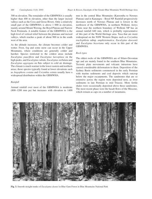
Fig. 3. Smooth straight trunks <strong>of</strong> Eucalyptus deanei in <strong>Blue</strong> Gum Forest in <strong>Blue</strong> <strong>Mountains</strong> National Park