The Eucalypts of the Greater Blue Mountains World Heritage Area ...
The Eucalypts of the Greater Blue Mountains World Heritage Area ...
The Eucalypts of the Greater Blue Mountains World Heritage Area ...

You also want an ePaper? Increase the reach of your titles
YUMPU automatically turns print PDFs into web optimized ePapers that Google loves.
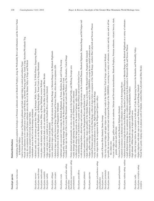
438 Cunninghamia 11(4): 2010 Hager & Benson, <strong>Eucalypts</strong> <strong>of</strong> <strong>the</strong> <strong>Greater</strong> <strong>Blue</strong> <strong>Mountains</strong> <strong>World</strong> <strong>Heritage</strong> <strong>Area</strong><br />
Eucalypt species Habitat/distribution<br />
Eucalyptus moluccana • undulating hills and escarpment footslopes on Permian sediments and on Bindook Porphyry along <strong>the</strong> Wollondilly River and tributatries and <strong>the</strong> lower Nattai<br />
& Kedumba Valleys<br />
• mid to lower protected slopes on Narrabeen sediments and shale capped ridges in central and nor<strong>the</strong>rn Yengo<br />
• basalt caps diatremes in low rainfall areas <strong>of</strong> Yengo and Wollemi, eg Mounts Wareng and Yengo, Sandy Camp, Kerrabee/Woodlands Trig<br />
• steep, dry escarpment slopes on Permian sediments above <strong>the</strong> floor <strong>of</strong> <strong>the</strong> Hunter Valley in Yengo and Wollemi<br />
• on limestone around Crown Creek, Capertee Valley<br />
• rainshadow areas in <strong>the</strong> Coxs & Kowmung catchments<br />
Eucalyptus moorei • skeletal sandy soils at elevations greater than 700m, eg Kanangra Walls, Narrow Neck, Ti Willa Plateau, Gangerang Plateau<br />
Eucalyptus muelleriana • moderately deep soils on <strong>the</strong> Bindook Highlands, eg Bullnigang Heights, Tomat Creek to Nyanga Mountain<br />
Eucalyptus multicaulis • rock plates with skeletal sandy soils below 900m, eg Kings Tableland, western Wollemi<br />
Eucalyptus notabilis • interbanded and residual shale soils on sandstone ridges <strong>of</strong> <strong>the</strong> <strong>Blue</strong> Labyrinth and <strong>Blue</strong> Breaks<br />
Eucalyptus nubila • ridges and slopes in low rainfall areas in <strong>the</strong> Goulburn River catchment (limited)<br />
• hills near Watch House Creek (limited)<br />
Eucalyptus obliqua • moist, sheltered slopes and gullies <strong>of</strong> <strong>the</strong> high elevations from Black Range, to Murruin Range to <strong>the</strong> Bindook Highlands<br />
Eucalyptus oreades • sheltered slopes and gullies between Kings Tableland and Newnes Plateau, <strong>of</strong>ten above escarpment cliffs<br />
• sheltered positions on <strong>the</strong> Nattai and Wanganderry Tablelands<br />
Eucalyptus ovata • tableland soaks associated with swamps <strong>the</strong> Bindook Highlands, eg Tomat, Random, Back and Colong Swamp<br />
• along gently sloping drainage lines on <strong>the</strong> <strong>of</strong> <strong>the</strong> Boyd Plateau and at upper Martins Creek<br />
Eucalyptus paniculata subsp. • residual shale caps on ridges <strong>of</strong> <strong>the</strong> Lower <strong>Blue</strong> <strong>Mountains</strong> and south east Wollemi, eg <strong>The</strong> Ironbarks, Culoul Range<br />
paniculata<br />
Eucalyptus parramattensis subsp. • better-drained and permanently wet sites on deep sands in <strong>the</strong> Garland Valley and Mellong Swamps area<br />
parramattensis<br />
• sandy drainage flats adjoining <strong>the</strong> eastern side <strong>of</strong> Thirlmere Lakes (limited)<br />
• colluvial soils along <strong>the</strong> larger creeks <strong>of</strong> <strong>the</strong> western Capertee valley (limited)<br />
Eucalyptus pauciflora • on undulating terrain or in cold hollows on granite on <strong>the</strong> Boyd Plateau and around Jenolan Caves<br />
• cold air drainage hollows, alluvial bogs and rock plates at high elevations on <strong>the</strong> Loombah Plateau, Bindook Highlands, Murruin Range and Mt Fatigue trail<br />
Eucalyptus pilularis • enriched sandstones between <strong>the</strong> Warragamba River and Erskine Creek<br />
• shale influenced ridges, slopes and gullies <strong>of</strong> <strong>the</strong> Oakdale Plateau, eg Green Hill, Waterfall Creek, Pumpkin Hill (limited)<br />
Eucalyptus piperita • slopes, gullies and ridges with deeper soils on sandstones across much <strong>of</strong> <strong>the</strong> GBMWHA, except <strong>the</strong> low rainfall nor<strong>the</strong>rn areas<br />
• residual Permian outcrops on Scotts Main Range; colluvial slopes below escarpment <strong>of</strong> <strong>the</strong> Tonalli Range, sou<strong>the</strong>rn <strong>Blue</strong> Labyrinth and Newnes Plateau<br />
• rocky soil on residual plateaus or ridges, High Gangerangs to Black Range<br />
Eucalyptus polyan<strong>the</strong>mos subsp. • talus slopes below <strong>the</strong> escarpment in <strong>the</strong> Wolgan and Capertee valleys<br />
polyan<strong>the</strong>mos<br />
Eucalyptus praecox • north <strong>of</strong> Rowans Hole (limited), Dunns Swamp<br />
Eucalyptus prominula • dry rocky exposed ridges and upper slopes on sandstone south <strong>of</strong> <strong>the</strong> Old Settlers Trail in Yengo, and eastern Wollemi<br />
Eucalyptus punctata • possibly <strong>the</strong> most frequently recorded and widespread Eucalypt <strong>of</strong> <strong>the</strong> GBMWHA, occurring on a variety <strong>of</strong> substrates, in wetter and dry areas and in all but<br />
<strong>the</strong> coldest sites<br />
• occurs on ridges, slopes, gullies and talus on sandstone, Silurian and Devonian metasediments, Bindook Porphyry, Permian sediments, volcanic breccia, shale,<br />
granite, alluvium and colluvium.<br />
Eucalyptus quadrangulata • between Yerranderie and <strong>the</strong> Bindook Highlands (limited)<br />
• scattered occurrences on sheltered sites in tributaries <strong>of</strong> <strong>the</strong> Coxs & Kowmung Rivers<br />
Eucalyptus radiata subsp. radiata • sheltered situations at high elevations from Black Range, Jenolan Caves and Boyd Plateau to Murruin Range to <strong>the</strong> Bindook Highlands on a variety <strong>of</strong> substrates<br />
• small sheltered drainage lines on sandstone above sou<strong>the</strong>rn escarpment from Katoomba to Wentworth Falls and Newnes Plateau<br />
• sheltered slopes beneath <strong>the</strong> escarpments in <strong>the</strong> Megalong and Kedumba Valleys<br />
• high altitude >900m basalt caps in high rainfall areas<br />
Eucalyptus ralla • dry colluvial slopes below <strong>the</strong> escarpment on both sides <strong>of</strong> Lake Burragorang betweeen <strong>the</strong> Kedumba and Wollondilly Valley<br />
Eucalyptus resinifera subsp. • higher ridgelines with shale caps in south east Wollemi, eg Culoul Range (limited)<br />
resinifera<br />
• broad flat to gently sloping sites on plateaus north <strong>of</strong> Oakdale, sou<strong>the</strong>rn <strong>Blue</strong> Labyrinth and <strong>Blue</strong> Breaks