

The Use of Wetlands for Flood Attenuation FINAL REPORT - An Taisce
The Use of Wetlands for Flood Attenuation FINAL REPORT - An Taisce
The Use of Wetlands for Flood Attenuation FINAL REPORT - An Taisce

Create successful ePaper yourself
Turn your PDF publications into a flip-book with our unique Google optimized e-Paper software.
<strong>The</strong> <strong>Use</strong> <strong>of</strong> <strong>Wetlands</strong> <strong>for</strong> <strong>Flood</strong> <strong>Attenuation</strong> Aquatic Services Unit, UCC<br />
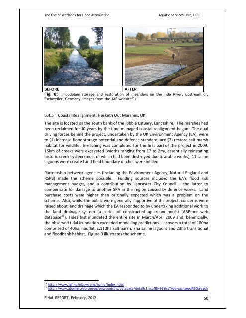
BEFORE AFTER<br />
Fig. 8: <strong>Flood</strong>plain storage and restoration <strong>of</strong> meanders on the Inde River, upstream <strong>of</strong>,<br />
Eschweiler, Germany (images from the JAF website 24 )<br />
6.4.5 Coastal Realignment: Hesketh Out Marshes, UK.<br />
<strong>The</strong> site is located on the south bank <strong>of</strong> the Ribble Estuary, Lancashire. <strong>The</strong> marshes had<br />
been reclaimed <strong>for</strong> 30 years by the time managed coastal realignment began. <strong>The</strong> dual<br />
driving <strong>for</strong>ces behind the project, undertaken by the UK Environment Agency (EA), were<br />
to (1) increase flood storage potential and defence standard, and (2) restore salt marsh<br />
habitat <strong>for</strong> wildlife. Breaching was completed <strong>for</strong> the first part <strong>of</strong> the project in 2009.<br />
15km <strong>of</strong> creeks were excavated (widths ranging from 17 to 2m), essentially reinstating<br />
historic creek system (most <strong>of</strong> which had been destroyed due to arable works); 11 saline<br />
lagoons were created and field boundary ditches were infilled.<br />
Partnership between agencies (including the Environment Agency, Natural England and<br />
RSPB) made the scheme possible. Funding sources included the EA’s flood risk<br />
management budget, and a contribution by Lancaster City Council – the latter to<br />
compensate <strong>for</strong> damage to another SPA in the region caused by defence works. Land<br />
purchase costs were higher than originally expected which was a problem on the<br />
scheme. Also, whilst the public were generally supportive <strong>of</strong> the project, concerns were<br />
raised about land drainage which the EA responded to by undertaking additional work to<br />
the land drainage system (a series <strong>of</strong> constructed upstream pools) (ABPmer web<br />
database 25 ). Tides first inundated the entire site in March/April 2009 and, beneficially,<br />
the observed tidal inundation exceeded modelling predictions. It covers a total <strong>of</strong> 180ha<br />
comprised <strong>of</strong> 40ha mudflat, c.110ha saltmarsh, 7ha saline lagoons and 23ha transitional<br />
and floodbank habitat. Figure 9 illustrates the scheme.<br />
24 http://www.jaf.nu/nieuw/eng/home/index.html<br />
25 http://www.abpmer.net/omreg/easycontrols/database/details1.asp?ID=93&lstType=Managed%20breach<br />
<strong>FINAL</strong> <strong>REPORT</strong>, February, 2012 50