Full Text (PDF)
Full Text (PDF)
Full Text (PDF)

Create successful ePaper yourself
Turn your PDF publications into a flip-book with our unique Google optimized e-Paper software.
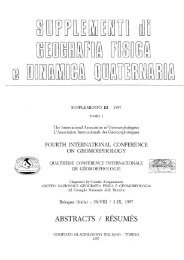
most the entire region from north to south and is still evident<br />
today. To the east, a very high ridge (Mt. Nerone, Mt.<br />
Catria and Mt. Brunette), prevented the water outflow towards<br />
the Adriatic Sea. To the west, the Mts. Martani, the<br />
Mts. Amerini and Perugini ridges prevented the runoff to<br />
the Tyrrhenian Sea. Thus the Umbrian depression began<br />
to flood and became a lake basin, known in geological literature<br />
as the «Grande Lago Tiberino» or more properly<br />
as the «Tiberino Basin», which was at times a lake, at<br />
times a marsh and at other times a swamp (fig. 1).<br />
Close to Perugia, the basin splits in two arms, the western<br />
one is the Valle Amerina and the eastern one the Valle<br />
Umbra. The latter has been the theatre of successive waves<br />
of human settlement since the 1st millennium BC.<br />
The purpose of the present paper is to attempt to correlate<br />
and reveal the mutual influences between historical<br />
events in the Valle Umbra and the environment changes<br />
induced by climate variations, during three millennia, from<br />
1000 BC up until the present day. The Valle Umbra has<br />
been selected because it is a confined zone, flat, highly<br />
conditioned by climate change and the site of great many<br />
historical events.<br />
The morphological situation of the valley was, and<br />
still is, peculiar: it is a SSE-NNW trending depression<br />
with a flat bottom and steep sides due to fault. Mt. Suba-<br />
108<br />
sio and a ridge with Mt. Brunette and Mt. Serano are on<br />
the east, and the Mts. Martani chain on the west. To the<br />
south the valley rises close to Spoleto in a kind of shell.<br />
Here the drainage is operated by a number of torrents<br />
(Tatarena, Marroggia, Tessino etc.) which converge towards<br />
the centre of the depression and progressively<br />
merge to form the main streams (Timia and Topino)<br />
draining the Valley northward. The hydrographical basin<br />
is around 170 km 2 (excluding the part pertaining to the<br />
Chiascio river). The only water outflow is towards the<br />
Chiascio river and the Tiber confluence at the Torgiano<br />
threshold. The declivity of the plain is very weak: from<br />
the Clitumno springs, to the Tiber confluence, the rise<br />
is 45 meters and the distance is 40 km, so the mean is<br />
around 1,2‰. Furthermore, the dip is not continuous,<br />
there are entirely flat or basin shaped zones, as well as<br />
slightly raised ridges due to the sand settling tributaries<br />
(fig. 2).<br />
On the valley bottom the lacustrine and fluvial deposits,<br />
made of clay interbedded with sandy levels, lignite<br />
beds, scattered conglomerates and palaeosoils, are<br />
some hundreds of meters thick, and are evidence of tectonic<br />
subsidence as well as lacustrine environment with<br />
lateral tributaries carrying sediments, alternating with<br />
swampy phases with peat and lignite deposition, and<br />
FIG. 1 - Central Italy structural<br />
scheme during Pliocene. The NW-<br />
SE trending ridges and the interposed<br />
basins are evident.<br />
Scale 1:1.400.000