Full Text (PDF)
Full Text (PDF)
Full Text (PDF)

Create successful ePaper yourself
Turn your PDF publications into a flip-book with our unique Google optimized e-Paper software.
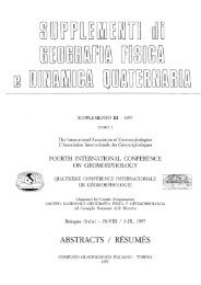
FIG. 5 - Hypothetical reconstruction of the Valle Umbra at the beginning of Roman domination. Towns and villages are on more or less elevated zones.<br />
Wide lakes prevail in the valley, and the ancient Via Flaminia (vetus) winds along the hills. The new Via Flaminia (recens) was built later, as were the<br />
towns of Bastia and Cannara on sites B and C (after Pietrangeli 1953; modified).<br />
sions with different orientations, obviously made in later<br />
periods in the Valle Umbra (Camerieri, 2006, 2007; Feruglio<br />
& alii, 1991; Manconi & alii, 1991) (fig. 7). The reconstruction<br />
of centuriated zones, has indicted that the wide<br />
lacustrine and swampy zones, which existed in the preceding<br />
century, were greatly reduced. It is realistic to imagine<br />
that as well as the change of climate, several drainage works<br />
112<br />
had been carried out in the valley in order to reclaim land<br />
for cultivation and stabilize its hydrography.<br />
b) Roads: the system of road in the valley plain was<br />
increased. The old Via Flaminia, which was an essential<br />
communication route from Rome to the northern provinces,<br />
mainly followed the hills and had several side lanes, but<br />
around the 2nd Century BC the section which led straight<br />
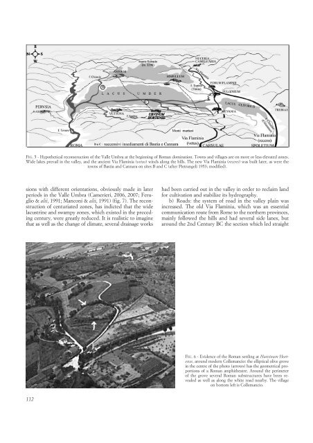
FIG. 6 - Evidence of the Roman settling at Hurvinum Hortense,<br />
around modern Collemancio: the elliptical olive grove<br />
in the centre of the photo (arrows) has the geometrical proportions<br />
of a Roman amphitheatre. Around the perimeter<br />
of the grove several Roman substructures have been revealed<br />
as well as along the white road nearby. The village<br />
on bottom left is Collemancio.